1854 Treaty Lands at Apostle Islands National Lakeshore
March 20, 2026
Collected & edited by Amorin Mello
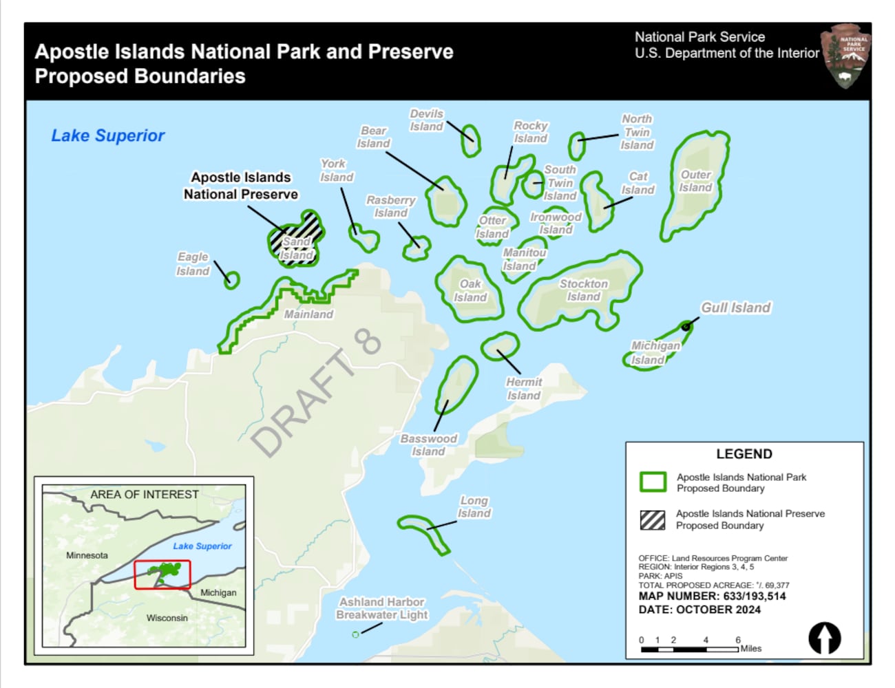 The Chequamegon area’s Apostle Islands National Lakeshore has been in the news lately due to the reintroduction of Congressman Tom Tiffany’s proposed Apostle Islands National Park and [Sand Island] Preserve Act. This proposed Act has been controversial due to strong opposition from local governments citing lack of consultation and insufficient infrastructure, among other concerns.
The goal of this post is to raise awareness about how the current Apostle Islands National Lakeshore contains roughly 3,000 acres of tribal lands reserved by the 1854 Treaty of La Pointe, and should consider returning these tribal lands back to the Lake Superior Chippewa before making any changes to become the proposed Apostle Islands National Park and Sand Island Preserve.
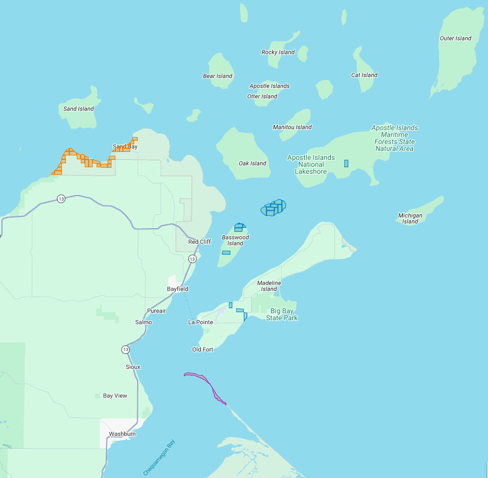
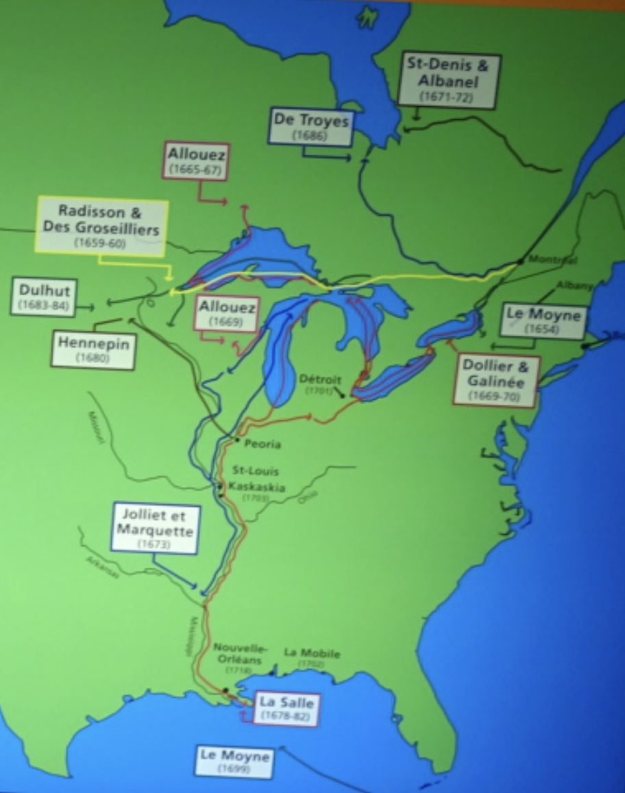
The current Apostle Islands National Lakeshore contains 3 types of lands reserved by the 1854 Chippewa Treaty of La Pointe:
29 Allotments (red) within the Red Cliff Reservation,
14 Allotments (blue) on Stockton, Hermit, & Basswood Islands,
and the disputed Bad River Reservation (purple) on Long Island.
All of the Apostle Islands are part of the ceded territory from the 1842 Treaty of La Pointe covering roughly 22,000 square miles in northern Wisconsin and Michigan. The historical context of this 1842 ceded territory was to allow Americans to move into copper-rich areas while still retaining hunting, fishing and gathering rights for the Lake Superior Chippewa on those same lands. In modern context, this 1842 ceded territory has natural resource managed jointly between the States of Michigan and Wisconsin, the Lake Superior Chippewa, and Great Lakes Indian Fish & Wildlife Commission (GLIFWC).
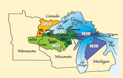
Map of 1836, 1837, 1842, and 1854 ceded territories jointly managed by the Great Lakes Indian Fish & Wildlife Commission (GLIFWC).
The 1854 Treaty of La Pointe reclaimed certain lands within the 1842 ceded territory to be reserved as permanent homelands for the Lake Superior Chippewa Bands in the form of Reservations and Allotments. For more information, we have covered the debates and circumstances leading up to the creation of these Reservations and Allotments in great detail on this blog, such as the Sandy Lake Tragedy and Ojibwe Removal events. Unfortunately much of those Reservations and Allotments have become “checkerboarded” or alienated from the Lake Superior Chippewa despite the original intention of being permanent homelands.
In this post we will examine roughly 3,000 acres of those Reservations and Allotments from the 1854 Treaty of La Pointe that are contained within the Apostle Islands National Lakeshore today. For clarification, there is a Reservation and several Allotments on Madeline Island, which are outside of the Apostle Islands National Lakeshore and will be discussed at a later date instead of in this post. Nor are we including any of the 1887 Dawes Act Allotments on the Apostle Islands in this post, because they are not from the 1854 Treaty.
Without further ado…
Zaagawaamikong-neyaashi
(roughly translated as “long soft beaver dam point”)
a.k.a. Chequamegon Point and Long Island
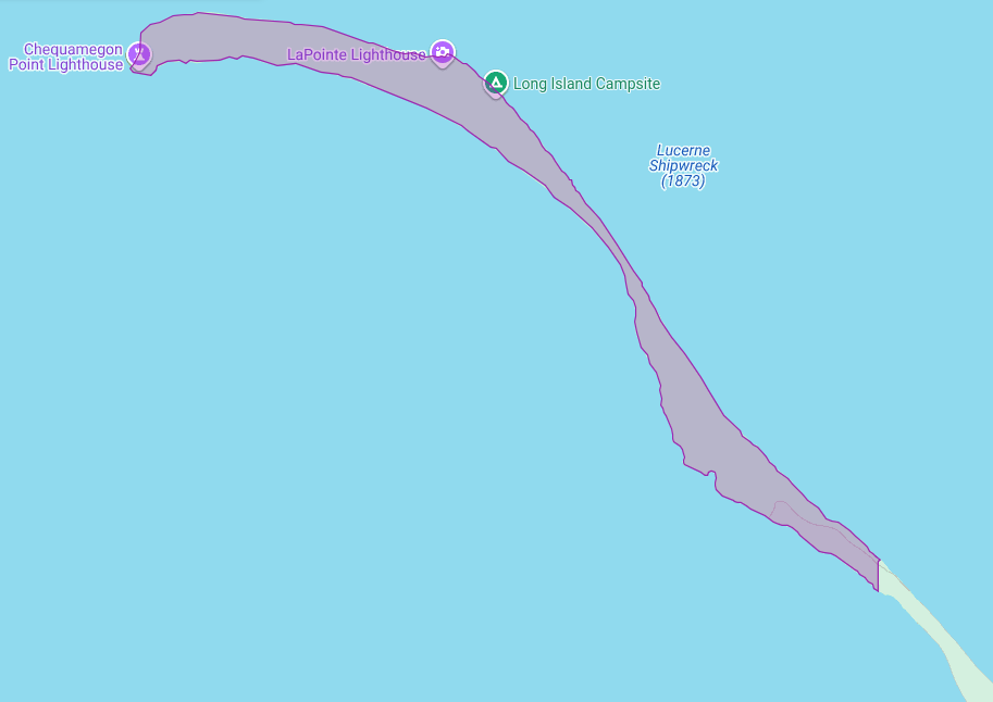
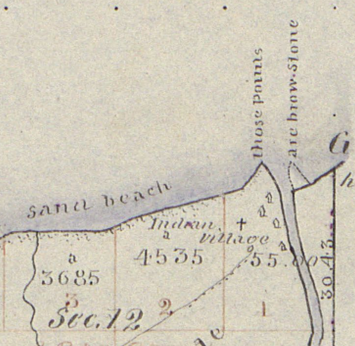
The Apostle Islands National Lakeshore contains Chequamegon Point (roughly 300 acres) on Long Island located at the Bad River Reservation (a.k.a. Mashkiiziibii).
Currently, federal maps of Long Island depict Chequamegon Point to lie outside the Bad River Reservation boundaries. Ownership of Chequamegon Point has been disputed between Bad River and the Federal Government for many generations since the 1854 Treaty.
This dispute is based on how the Second Clause of the Second Article of the 1854 Treaty of La Pointe defined the boundaries of the Bad River Reservation to follow “along the lake shore, crossing Shag-waw-me-quon [Chequamegon] Point, to the place of beginning“. In recent years, Bad River has been conducting a Historical Background Study about the 1854 Treaty of La Pointe and the Chippewa understanding of how they negotiated with Federal negotiators to include Chequamegon Point in Bad River’s lakeshore reservation boundaries.
We have mentioned this ongoing dispute in past posts, and will continue to examine historic records in support of Bad River’s efforts to repatriate tribal ownership of Chequamegon Point.
Gaa-giishkidaawangaa-wiikwedong
(roughly translated as “sand bay”)
a.k.a. Sand Point, Sand Bay, and Little Sand Bay
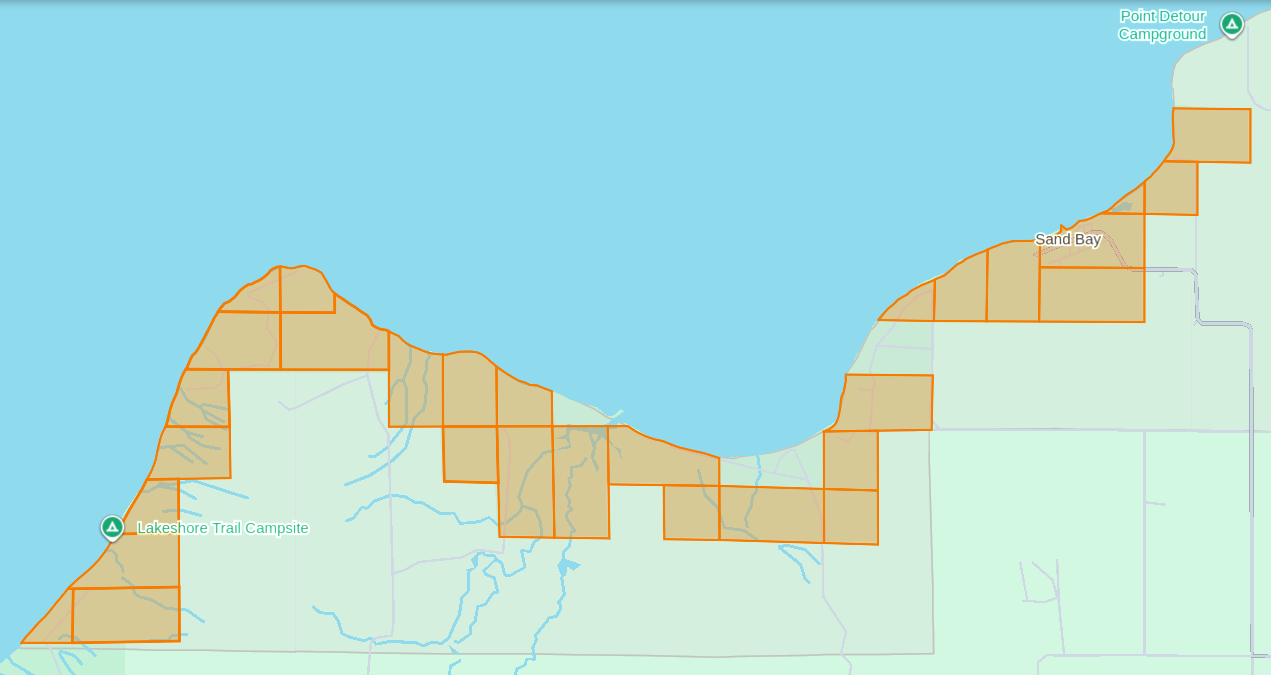
The Apostle Islands National Lakeshore’s Mainland Unit contains 29 Allotments (roughly 1,550 acres) located at the Red Cliff Reservation (a.k.a. Gaa-miskwaabikaang). The Sand Bay shoreline contains three Allotments (uncolored) that are owned by Red Cliff.
The media often cites the 1887 Dawes Act when describing how Allotments on the Lake Superior Chippewa Reservations became alienated from tribal ownership. That is factually incorrect, because these Allotments came from the 1854 Treaty of La Pointe, which precedes the 1887 Dawes Act by several decades. The key difference here is how these 1854 Chippewa Treaty Allotments were designed to reserve tribal land that would never be taken away later, while the later 1887 Dawes Act Allotments were designed to be alienated/sold after a period of 25 years. Unfortunately the 1854 Treaty Allotments were mismanaged by non-tribal governments as being temporary instead of permanent.
This mismanagement has caused much damage over time in the form of “checkerboarded” tribal land bases, which explains the legacy of how these 29 Allotments inside the Red Cliff Reservation fell out of tribal ownership and became part of the original boundaries of the Apostle Islands National Lakeshore.
In 1970, two additional Allotments along the Sand Bay shoreline were targeted to become part of the original boundaries of Apostle Islands National Lakeshore, but ultimately never became alienated from tribal ownership. Today these two Allotments still remain excluded from the boundaries of the current Apostle Islands National Lakeshore and proposed National Park.
In 2018, a third Allotment along Sand Bay that had fallen out of tribal ownership due to “checkerboarding” was repatriated from Town of Russell ownership back to tribal ownership, and is now a Tribal Management Unit of the Apostle Islands National Lakeshore.
The proposed boundaries of the Apostle Islands National Park and [Sand Island] Preserve Act contain this repatriated Allotment, but not the two Allotments that were never alienated from tribal ownership.
Wiisaakodewan-minis
(roughly translated as “half-burnt wood island”)
a.k.a. Stockton Island or Presque Isle
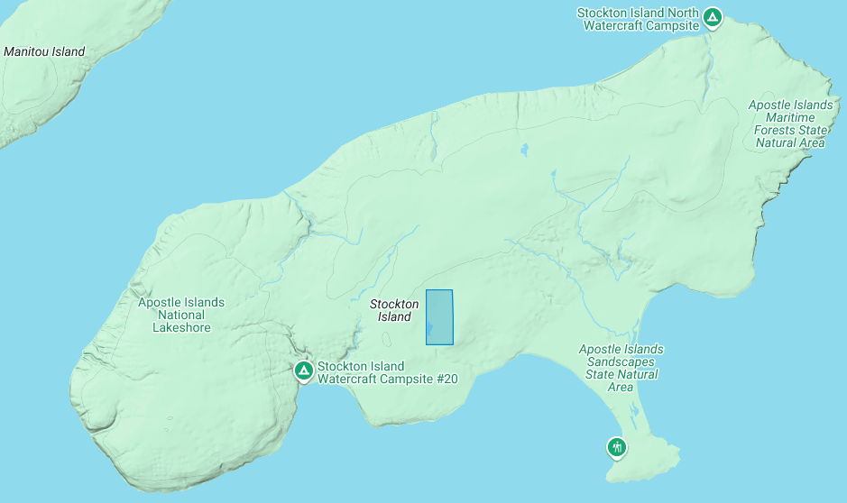
The Apostle Islands National Lakeshore contains one allotment (roughly 80 acres) on Stockton Island:
1) Joseph Gauthier (a.k.a. Gokee) Senior
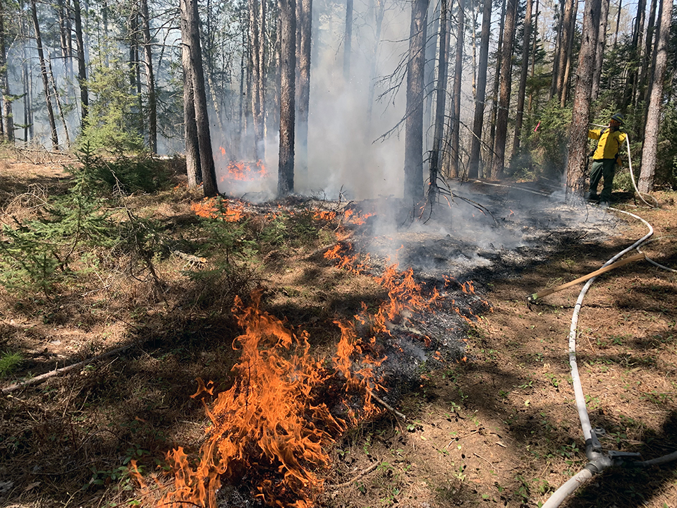
A prescribed fire on Stockton Island conducted by National Park Service and Tribal partners.
~ Photo by Dave Cooper at NPS
The root word of island’s traditional name, Wiisaakodewan (half-burnt wood), refers to Stockton Island’s historic appearance of being partially burnt. In recent years, the Apostle Islands National Lakeshore and the Lake Superior Chippewa have jointly reintroduced the practice of using prescribed fire management to promote the growth of blueberries and other traditional ecological resources on the cultural landscape of Stockton Island.
Wiisaakodewan also happens to be the root word of a pejorative slang term describing the Mixed Blood people of Lake Superior Chippewa. At the time of the Treaty Era, the Mixed Bloods of the Lake Superior Chippewa held a strong connection to this island via the tribal fishing industry. For example, the surveyor Joel Allen Barber described how “the bays on Presque Isle [Stockton Island] are a favorite resort of fishermen” in connection to the tribal fishing grounds of the La Pointe Indian Reservation on Madeline Island’s north end.
Wiigobiish-minis
(roughly translated as “basswood island”)
a.k.a. Basswood Island
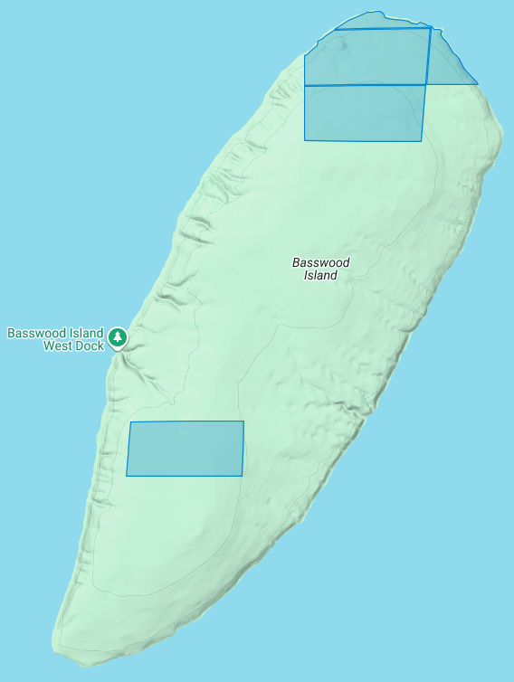
The Apostle Islands National Lakeshore contains four allotments (roughly 290 acres) on Basswood Island:
1) John Baptist Berriot
2) Henry Bresette (a.k.a. Brisette)
3) John Baptist Lemieux
4) Louis Neveaux
In a previous post we briefly mentioned that the infamous John Breckenridge made national news with his land speculation on Basswood Island immediately following the 1854 Treaty of La Pointe. In a few short years Breckinridge would become Vice President of the United States, and also a Confederate States Army brigadier general during the Civil War.
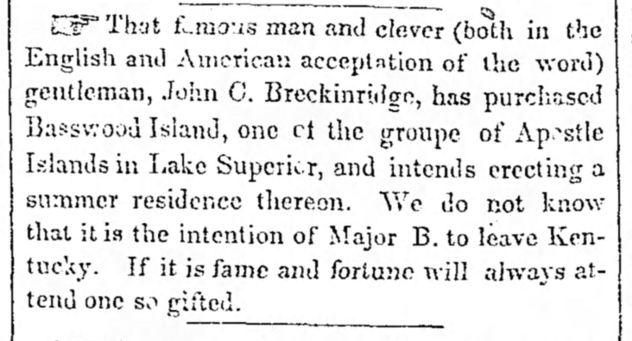
The Louisville Daily Courier [Kentucky], August 14th 1855, Page 4.
Eshkwegwindeg-minis
(roughly translated as “floating at the end or behind island”)
a.k.a. Hermit Island
f.k.a. Austrian Island
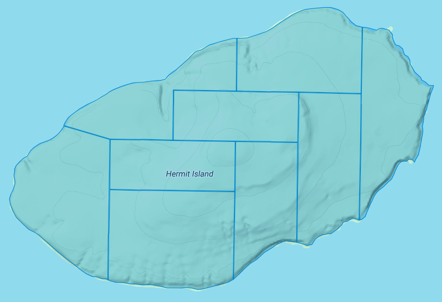
The Apostle Islands National Lakeshore contains nine allotments (roughly 780 acres) covering all of Hermit Island:
1) Josette Deefoe (a.k.a. Defoe)
2) Michael Defoe
3) Francois Dejadin (a.k.a. Artishon) Junior
4) Charles Dingley
5) Mary Dingley
6) Mary DuBay
7) Louis Gaudin (a.k.a. Gordon)
8) John Baptist Goslin (a.k.a. Gauslin)
9) Elizabeth (a.k.a. Isabella) Tremble
The traditional name of Eshkwegwindeg appears to be referencing this island’s location between the mainland and several other Apostle Islands. Today it still remains a central hub between the Red Cliff Reservation, the La Pointe Reservation on the north end of Madeline Island, and the other Apostle Islands with Allotments. It is noteworthy how the entirety of this Island is covered by Allotments, unlike the other aforementioned Islands.
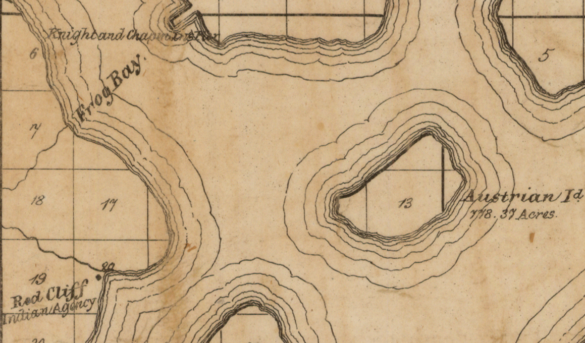
Austrian Island on Asaph Whittlesey’s 1871 map of Apostle Islands and Harbor of Bayfield and Its Surroundings.
~ Wisconsin Historical Society
Modern maps call this Hermit Island in reference to the colorful story of how William Wilson was ostracized from La Pointe and relocated to this Island to live out a solitary life during the Treaty Era. The famous “brownstone king” Frederick Prentice‘s connection to this Island in later decades is also a popular story being told by tour guides in modern times. However, I personally am more interested in exploring the history of how this Island was know as “Austrian Island” between the Wilson and Prentice eras, because it illustrates Julius Austrian’s abuse of Allotments to take private ownership of what should be tribal lands for personal profit.
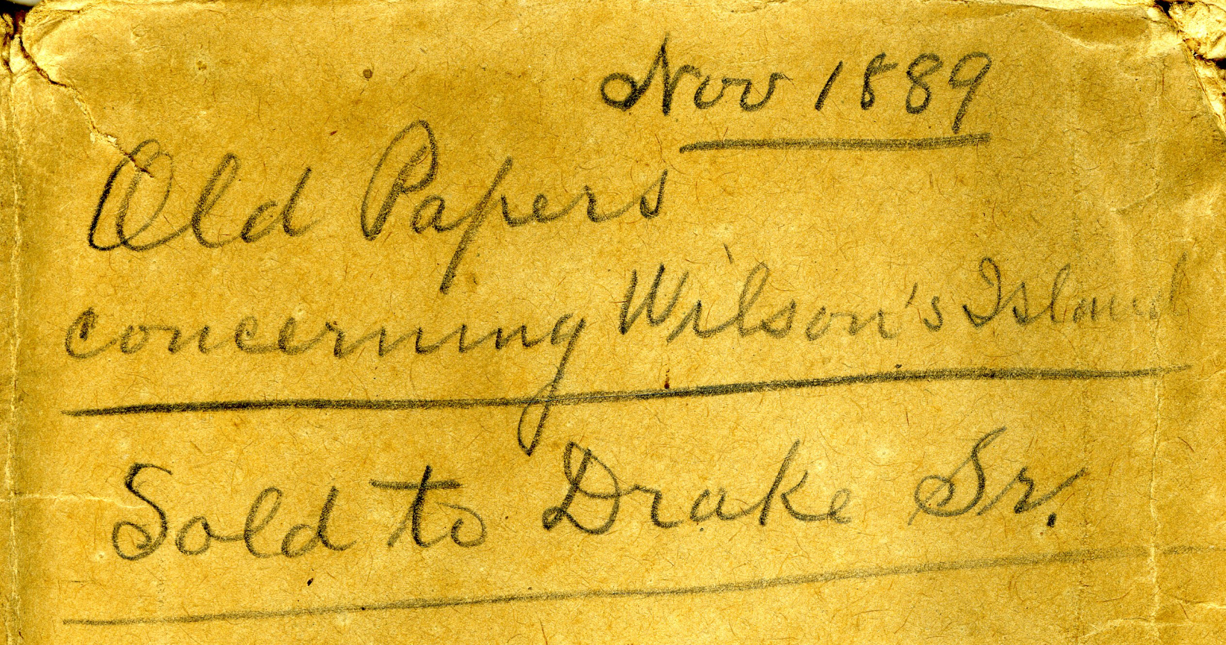
Madeline Island Museum
JULIUS AUSTRIAN PAPERS (2011.158.A) Folder 5:
PAPERS RELATING TO WILSON’S ISLAND (HERMIT ISLAND IN THE APOSTLE ISLANDS ARCHIPELAGO), WISCONSIN (1870-1888)
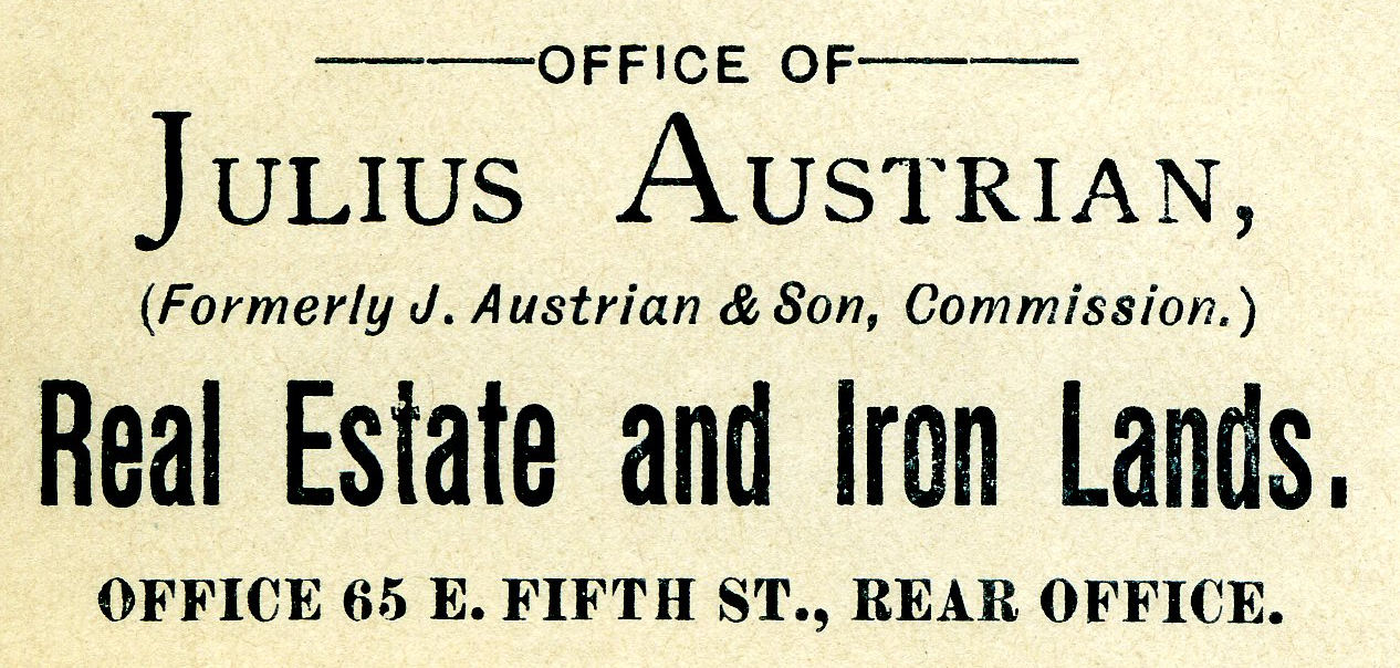
Julius Austrian’s corporate letterhead circa 1888 advertising Allotments for sale.
I personally became very interested in Chequamegon history specifically because of Julius Austrian and his abuse of Allotments to take private ownership of what should be tribal lands in the Penokee Mountains for personal profit, and how that legacy evolved to become what is still known as the La Pointe Iron Company today.
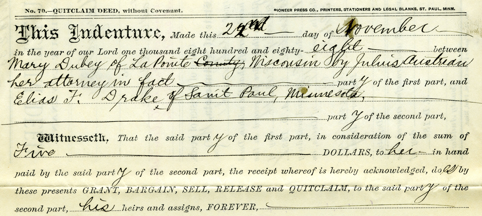
Example of Julius Austrian using Power Of Attorney to buy Mary DuBay’s Allotment for $5 so he could later flip it for profit as private property.
Austrian’s land speculation on Hermit Island follows the same trend of using Allotments via power of attorney over Mixed Blood tribal members of the Lake Superior Chippewa to grab ownership of prime real estate before other land speculators. In the Penokees example, Austrian gave each Mixed Blood $100 to sell their Allotments via Power of Attorney, but here we see how Austrian gave Mary DuBay only $5 for her Allotment on Hermit Island.
My research has been the foundation of academic research in Larry Nesper’s book Our Relations…the Mixed Bloods, and I will continue to post more on this topic in the Austrian Papers on this website.
So what?
Regular readers of Chequamegon History know that my writing style is to post historic documents enhanced with multimedia and sidebars, but omit my own interpretations and and just let readers reach their own conclusions. Leo, on the other hand, is more inclined to speak out about the implications, such as in his posts 19th Century Deer in the Headlights and Slavery, Debt Default, and the Sandy Lake Tragedy. However, in this case, due to Congressman Tom Tiffany’s ongoing efforts despite strong opposition from local governments, I felt it was important to expound on this issue a bit more than I usually do.
Righting a Wrong: Restoring Lands to the Leech Lake Band of Ojibwe
In 2020, the Leech Lake Band of Ojibwe Reservation Restoration Act (Public Law 116-255) returned approximately 11,760 acres of allotted lands wrongfully taken by the Chippewa National Forest back to Tribal ownership and management. The same concept should be applied to repatriate tribal lands in the Apostle Islands National Lakeshore before moving forward with the proposed Apostle Islands National Park and Preserve Act.
Lac Court Oreilles Band of Lake Superior Chippewa v. Walker, Evers
Tribes of the 1854 Chippewa Treaty in Michigan and Wisconsin have won two important lawsuits in recent years due to the fact that their tribal lands should have been reserved under the 1854 Treaty of La Pointe instead of becoming “checkerboarded” from illegal taxation/foreclosures.
Red Cliff Band of Lake Superior Chippewa Indians v. Bayfield County
What started off as a dispute about zoning authority over tribal lands has developed into a constructive partnership. Bayfield County and Red Cliff have developed a Memorandum of Understanding that has led to repatriation of tribal lands within the Red Cliff Reservation. This has led to 2,500 acres being returned by the County to Red Cliff in recent years, with the last 900 acres being completed in 2022.
While returning all County-owned surface rights within the Reservation back to the Tribe has been a tremendous achievement, the County still owns mineral rights within the Red Cliff Reservation. Mineral rights supersede land rights under Wisconsin law, so more work still remains to be done in these land repatriation efforts between Bayfield County and Red Cliff.
Bayfield County should promote their efforts in recent years to help Red Cliff repatriate 2,500 acres of County-owned lands back to tribal ownership, and encourage the Apostle Islands National Lakeshore to return their 3,000 acres of Reservation/Allotments back to tribal ownership.
Frog Bay Tribal National Park
Congressman Tom Tiffany claims that his proposed Apostle Islands National Park and Preserve Act would create the first National Park in Wisconsin. However, Red Cliff already earned that claim to fame in 2012 by establishing the Frog Bay Tribal National Park through an innovative partnership to repatriate Allotments on their Reservation from non-native landowners.
We would much rather see the establishment of a Sand Bay Tribal National Park in Red Cliff, a Chequamegon Point Tribal National Park in Bad River, and Tribal National Parks for the Apostle Islands Allotments, before the proposed Apostle Islands National Park and Preserve. Ultimately these Tribal Lands should be returned to the Lake Superior Chippewa and let them decide whether to manage them as Tribal National Parks or not.
Ruelle Chagouamigon du Vieux-Montréal
October 25, 2025
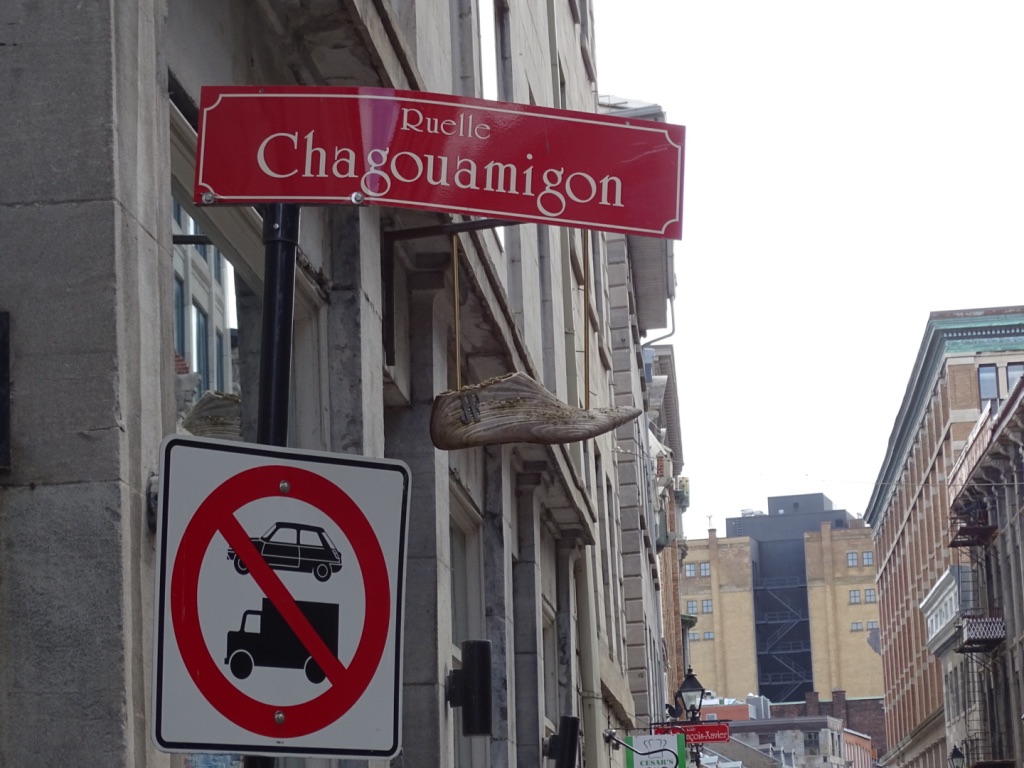
Photo taken by David Trudeau at Ruelle Chagouamigon, 2019.
A Street named for Chequamegon in Montreal.
Guest post by David Trudeau
French North America at the dawn of the 18th century was a vast network of French and Indigenous trading outposts spanning the entire Mississippi and St. Lawrence-Great Lakes watersheds with Montreal as its main hub. Chequamegon was a part of that network, and so notable, that a street in old Montreal was called “Rue Chagouamigon.”
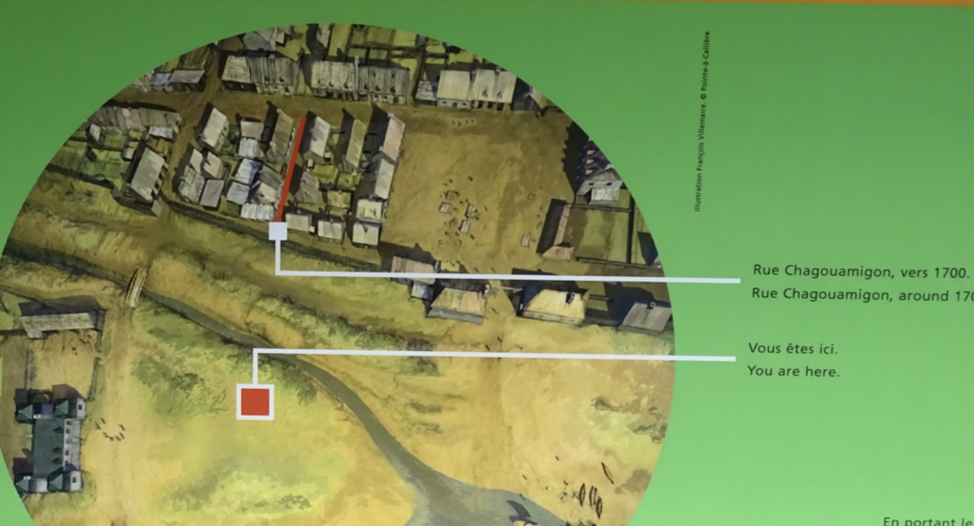
Model of Rue Chagouamigon circa 1700. Photo taken by David Trudeau at the Pointe-à-Callière Museum, 2019.
Madeline Island is approximately 1200 miles from Montreal, a journey of about 6 hours by plane — or one of up to two months by canoe and portage across Superior and Huron and down the Ottawa river. In the days of the voyageurs, the trip of trade goods to Lapointe and the return trip to Montreal of bundled beaver pelts was typically a once a season event. Circa 1700 “Chagouamigon” was a well enough known place in old Montreal to merit a street name.
Map of Montreal’s fur trade routes circa late 1600s. Photo taken by David Trudeau at the Pointe-à-Callière Museum, 2019.
The place name is French spelling of the Ojibwe term for “soft beaver dam”1 and a reference to Chequamegon point, so named by a local Ojibwe legend about a giant beaver dam (Long Island) and how the Apostle Islands archipelago was created. Was the name of the street whimsically chosen because of its beaver reference or was it more likely a reference to a place becoming well known to the fur trade. Today the street still exists in the in Vieux-Montreal, the old town. Time has changed its route to a mere one block, and it is now known as a “Ruelle,” a little street. There is a special mention of Ruelle Chagouamigon in the Pointe-à-Callière Museum, built on and incorporating the archaeologic remains of Ville-Marie, the beginnings of Montreal started in 1642.
Model of Ville Marie circa 1643. Photo taken by David Trudeau at the Pointe-à-Callière Museum, 2019.

Photo of wife taken by David Trudeau at Ruelle Chagouamigon, 2019.
As I visited the Pointe-à-Callière in May of 2019, researching and learning about my French colonial ancestors who were among Montreal’s founders, I was thrilled to find the exhibit showing the street. I was equally thrilled to walk right up to it as it exists today, and take a photo of my wife Karen on the street. Karen is not a big person, but the tiny narrow street makes her look enormous.

Excavated timbers beneath the Pointe-à-Callière Museum. Photo taken by Amorin Mello, 2023.
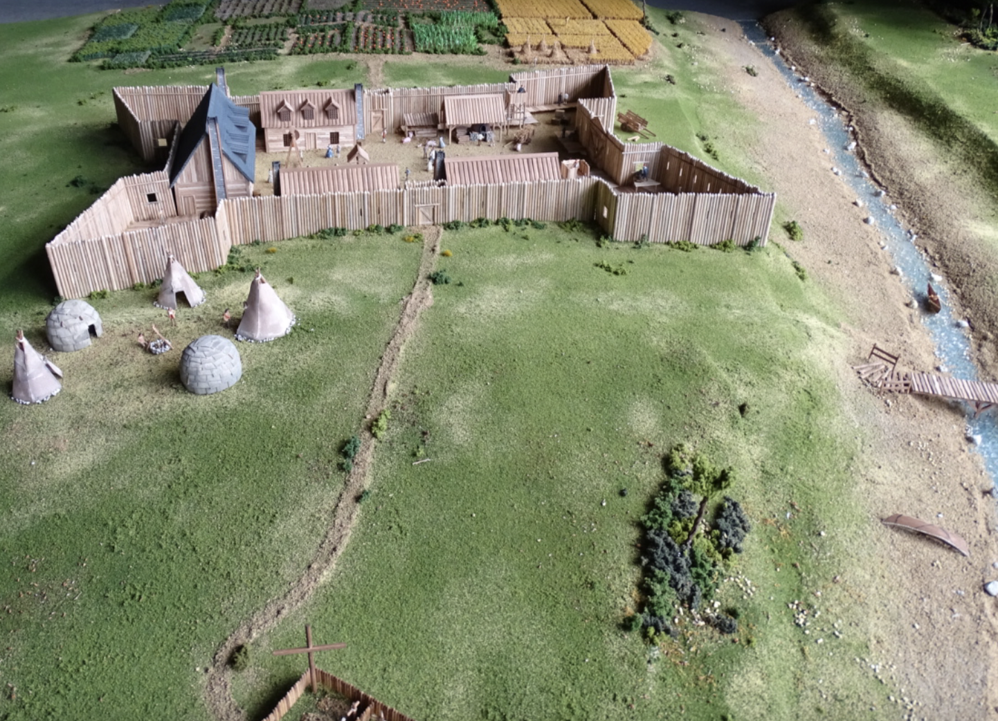
Montreal began as a mission outpost, Ville-Marie, founded in 1642 by a lay missionary society, with the objective of building a hospital to care for Indigenous people, and establishing a mission. Many of the missions early contacts and converts were Algonquin speakers. The excavations inside the museum show original posts and timbers of Ville-Marie likely laid out by carpenter Gilbert Barbier, my 8x great grandfather.2
Ville-Marie’s existence was touch and go because of constant predation by Mohawk Haudenosaunee. By 1685, Ville-Marie was home to some 600 colonists, most of them living in modest wooden houses. Ville-Marie became a centre for the fur trade and a base for further exploration3. Etienne Truteau, my 7x great grandfather, arrived in 1659, and had 13 sons with his wife Adrianne Barbier. Many of their boys worked the fur trade routes when they were younger – usually from age 15 to 25. They saved up and bought land and married about age 25.
~ Quebec Commission de Toponymie
~ Montreal.ca
~ WalkMontreal.com
Their son, my 6x great grandfather Pierre, spent 10 years contracted between Montreal, Mackinac and Green Bay. On July 31, 16884, Pierre Truteau dit Barbier (1669-1740), the second son of Etienne, joined Nicolas Perrot for the Outaouais (Ottawa), which probably led him to Baie des Puants (Green Bay, Wisconsin)5. Alone or with other companions, over the next decade, Pierre contracted no less than seven times to equip himself for trading, going to the Maskutins (Sac) of western Lake Michigan, the Huron of Lake Huron and the Ottawa at Michilimackinac. He abandoned the fur trade in 1698 to marry and cultivate the land of his grandfather Gilbert Barbier at Côte Saint-François (Longue-Pointe).6 His nephew Toussaint (1716-1782), a blacksmith and cutter by trade, committed for a period of three years in 17367 to Messrs De la Ronde and Guillory, to go to the post of “Chagouamigon” and help paddle a canoe of trade goods up to the De la Ronde post on Madeline Island and bring it down again loaded with furs. He traveled again in 17488 for the society of Sieurs De Clignancourt, L’Échelle and Monière, on Lake Michigan, namely to the post at Baie des Puants, as part of a group of thirty-eight men in six canoes.9
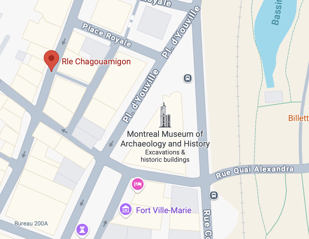
Google Map of Ruelle Chagouamigon and the Pointe-à-Callière Museum in Vieux-Montréal.

La ruelle Chagouamigon (Ebook)
Histoire de Montréal: édition 375e anniversaire de la fondation de Montréal by Yvon Codère, 2016.
Today Montreal is a huge metro area, but in its oldest part there is a tiny street, a block long and so narrow that it is restricted from cars and trucks. The street commemorates Montreal’s historic connections to Chequamegon Bay. And as a personal note, there are also traces there of my French ancestors who arrived almost 400 years ago, some of whom made the long paddle with many portages up the Ottawa and across the great lakes to Madeline Island. They were able to do so only because their friends and trading partners, the Algonkian peoples, showed them the way to survive on the journey, and provided them with food and canoes. I find it amazing that I live in the Chequamegon Bay area and share a surname with long ago Montreal ancestors who are connected to a tiny street there named for the area I call home.
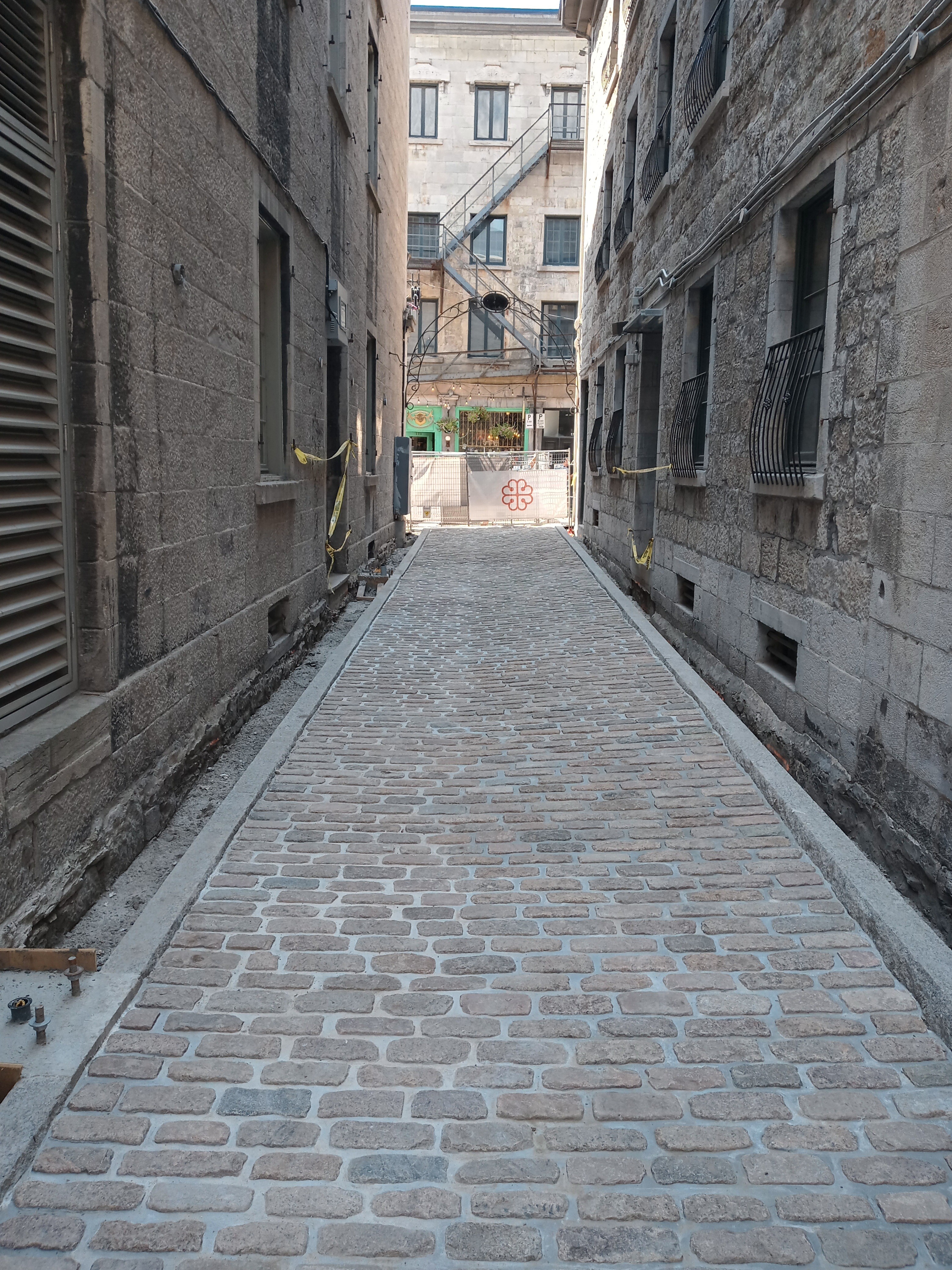
Ruelle Chagouamigon after being completely excavated for archaeological research and rebuilt. Photo taken by Francis Hervieux of the Pointe-à-Callière Museum in 2025.
—————
1 https://chequamegonhistory.com/about/.
2 Dollier de Casson, François (1636-1702) A History of Montreal 1640—1672 from the French of Dollier de Casson, translated and edited with a Life of the Author by Ralph Flenly, 1928. London & Toronto, J. M. Dent & sons, Ltd.; New York, E. P. Dutton & co. p. 103.
3 Miquelon, Dale. “Ville-Marie (Colony)“. The Canadian Encyclopedia. Archived from the original on December 3, 2013. Retrieved 22 October 2025.
4 Notary Antoine Adhémar, Library and Archives nationales du Québec (BANQ).
5 Claude Perrault “PERROT, NICOLAS”, in Dictionary of Canadian Biography, vol. 2, Laval University / University of Toronto, 2003.
6 Louise Trudeau “The History Page” Voyageur Sons Le Charpente December Volume 10 No 3, 2017.
7 Notary François Le Pallieur, Minute # 1022, Library and Archives nationales du Québec (BANQ).
8 Notary Louis-Claude Danré of Blanzy, BANQ.
9 Notary Louis-Claude Danré of Blanzy, BANQ.
Bishop Baraga Crosses Lake Superior
February 18, 2025
Collected & edited by Amorin Mello

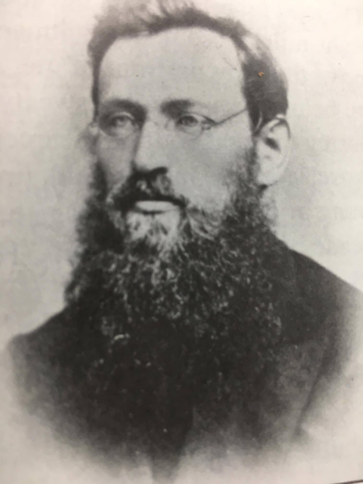
Bishop Irenaeus Frederic Baraga
~ Madeline Island Museum
This post features oral legends recorded about two of Bishop Irenaeus Frederick Baraga’s traverses from La Pointe across Lake Superior:
A) to Minnesota’s Cross River by canoe.
B) to Michigan’s Ontonagon River by ice.
In chronological order of publication, the first record was from a German traveloguer, the next two were from Catholic missionaries, and the last two were from Bad River tribal members.
- Kitchi-Gami, by Johann Georg Kohl, 1859/1860.
- Life and Labors of Bishop Baraga, by Rev. Chrysostom Verwyst, 1896.
- Life and Labors of Rt. Rev. Frederick Baraga, by Rev. Verwyst, 1900.
- Chippewa Indian Historical Project, by United States WPA, 1936-1942.
- Chippewa Indian Historical Project, by United States WPA, 1936-1942.

Originally published in German as
Kitschi-Gami; Oder, Erzählungen Vom Obern See
by Johann Georg Kohl, 1859.
Translated and republished in English as
Kitch-Gami: Wanderings Round Lake Superior,
By Johann Georg Kohl, 1860,
Pages 180-183.

German traveloguer
Johann Georg Kohl
Du Roy: “Do you known the summer voyage our most reverend friend, your companion, once made in a birch-bark canoe right across Lake Superior? Ah! that is a celebrated voyage, which everybody round the lake is acquainted with. Indeed, there is hardly a locality on the lake which is not connected with the history of his life, either because he built a chapel there, or wrote a pious book, or founded an Indian parish, or else underwent danger and adventures there, in which he felt that Heaven was protecting him.
“The aforesaid summer voyage, which I will tell you here as companion to his winter journey, was as follows:
“He was staying at that time on one of the Islands of the Apostles, and heard that his immediate presence was required at one of the little Indian missions or stations on the northern shore of the lake. As he is always ready to start at a moment, he walked with his breviary in his hand, dressed in his black robe, and with his gold cross fastened on his breast – he always travels in this solemn garb, on foot or on horseback, on show-shoes or in a canoe – he walked, I say, with his breviary in his hand and his three-corned hat on his head, into the hut of my cousin a well-known Voyageur, and said to him: ‘Dubois, I must cross the lake, direct from here to the northern shore. Hast thou a boat ready?’
” ‘My boat is here,’ said my cousin, ‘but how can I venture to go with you straight across the lake? It is seventy miles, and the weather does not look very promising. No one ever yet attempted this “traverse” in small boats. Our passage to the north shore is made along the coast, and we usually employ eight days in it.’
” ‘Dubois, that is too long; it cannot be. I repeat it to thee. I am called. I must go straight across the lake. Take thy paddle and “couverte,” and come!’ And our reverend friend took his seat in the canoe, and waited patiently till my obedient cousin (who, I grant, opened his eyes very wide, and shook his head at times) packed up his traps, sprang after him and pushed the canoe on the lake.
“Now you are aware, monsieur, that we Indians and Voyageurs rarely make greater traverses across the lake than fifteen miles from cape to cape, so that we may be easily able to pull our boats ashore in the annoying caprices of our weather and water. A passage of twenty-five or thirty miles we call a ‘grand traverse,’ and one of seventy miles is a impossibility. Such a traverse was never made before, and only performed this once. My cousin, however, worked away obediently and cheerfully, and they were soon floating in their nutshell in the middle of the lake like a loon, without compass and out of sight of land. Very soon, too, they had bad weather.
“It began to grow stormy, and the water rose in high waves. My cousin remarked that he had prophesied this, but his pious, earnest passenger read on in his breviary quietly, and only now and then addressed a kind word of encouragement to my cousin, saying that he had not doubted his prophecy about the weather, but he replied to it that he was called across the lake, and God would guide them both to land.
“They toiled all night through the storm and waves, and, as the wind was fortunately with them, they moved along very rapidly, although their little bark danced like a feather on the waters. The next morning they sighted the opposite shore. But how? With a threatening front. Long rows of dark rocks on either side, and at their base a white stripe, the dashing surf of the terribly excited waves. There was no opening in there, no haven, no salvation.
” ‘We are lost, your reverence,’ my cousin said, ‘for it is impossible for me to keep the canoe balanced in those double and triple breakers; and a return is equally impossible, owing to the wind blowing so stiffly against us.’
” ‘Paddle on, dear Dubois – straight on. We must get through, and a way will offer itself.’
“My cousin shrugged his shoulder, made his last prayers, and paddled straight on, he hardly knew how. Already they heard the surf dashing near them; they could no longer understand what they said to each other, owing to the deafening noise, and my cousin slipped his couverte from his shoulders, so as to be ready for a swim, when, all at once, a dark spot opened out in the white edge of the surf, which soon widened. At the same time the violent heaving of the canoe relaxed, it glided on more tranquilly, and entered in perfect safety the broad mouth of a stream, which they had not seen in the distance, owing to the rocks that concealed it.
” ‘Did I not say, Dubois, that I was called across, that I must go, and that thou wouldst be saved with me? Let us pray!’ So the man of God spoke to the Voyageur after they had stepped ashore, and drawn their canoe comfortably on the beach. They then went into the forest, cut down a couple of trees, and erected a cross on the spot where they landed, as a sign of their gratitude.
“Then they went on their way to perform their other duties. Later, however, a rich merchant, a fur trader, came along the same road, and hearing of this traverse, which had become celebrated, he set his men to work, and erected at his own expense, on the same spot, but on a higher rock, a larger and more substantial cross, which now can be seen a long distance on the lake, and which the people call ‘the Cross of —–‘s Traverse.’”

Historical Collections and Researches of Michigan Pioneer and Historical Society: Vol. XXVI,
by Michigan State Historical Society, 1896,
pages 541-542.
LIFE AND LABORS OF BISHOP BARAGA
A short sketch of the life and labors of Bishop Baraga
The Great Indian Apostle of the Northwest.
By Rev. Chrysostom Verwyst O.S.F. of Ashland, Wis.
Father John Chebul arrived on Lake Superior at the Sault in October 1859 to assist his fellow Slovanian Bishop Baraga. Chebul spent the winter at Ontonagon with miners before arriving at La Pointe in May 1860.
On another occasion Father Baraga went to Ontonagon from La Pointe. We will relate the incident as told to the writer by Rev. John Cebul, of Newberry, Mich. He was well acquainted with Bishop Baraga, being a fellow countryman who had been sent to La Pointe in 1860, where he labored amongst the Chippewas of that island and Bayfield, Bad River Reserve, Superior and other places, for about thirteen years, being universally loved and esteemed by all. He says:
Bishop Baraga was intending to go on the ice to Ontonagon. He was accompanied by a man from the island. The reason they took to the ice was because it was much nearer and the walking a great deal better than on the main land. During March and April the ice on Lake Superior becomes honey-combed and rotten. If a strong wind blows, it cracks and moves from the shore if the wind blows from the land. Such fields of ice does not notice that he is in danger till he comes to the edge of the ice and then to his horror discovers a large expanse of open water between him and the mainland. Should the ice float out towards the middle of the lake or break up, he is lost. Father Baraga and his companion had traveled on the ice for some time, thinking all was right. All at once they came to the edge of the ice and saw it was impossible to reach land, as the wind had driven the ice from the shore out into the Lake. His companion became greatly alarmed. Father Baraga remained calm, praying, no doubt, fervently to Him who alone could save them. Finally the wind changed and drove the cake of ice on which they were floating to the shore. They landed at Cadotte point, about 20 or 30 miles from Ontonagon, having been carried by the wind on their ice raft about sixty miles. “See,” said the good priest to his companion, “we have traveled a great distance and yet have not labored.” It seems the good God wanted to save the saintly missionary a long and painful walk, by giving him a ride of sixty miles on a cake of ice.

Life and labors of Rt. Rev. Frederic Baraga
by P. Chrysostomus Verwyst, 1900,
pages 219-222.
“Louis Gaudin“ was one of several legendary children born to Jean Baptiste Gaudin, Sr. and Awenishen (a sister of Hole-in-the-day):
– Antoine Gordon
– Elizabeth (Gordon) Belanger
– Louison Gordon, Sr.
– Harriet (Gordon) Lemon
– John Baptiste Gordon, Jr.
– Angelique Gordon
– Joseph GordonLouison Gordon, Sr. (1814-1899) married Julia Brebant, whose sisters were married to Henry Bresette and Judge John W. Bell.Wizon is an objibwecized form of the francophone name Louison.
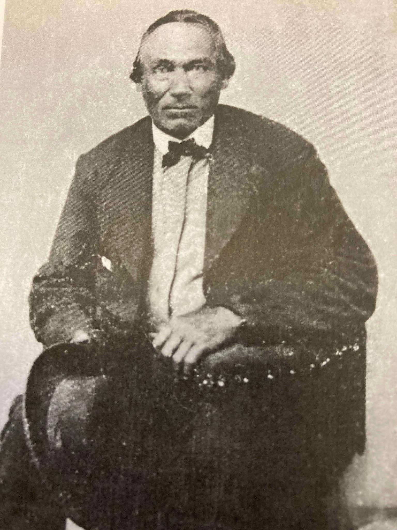
Undated photo from the Gordon Museum thought to be a brother of Antoine Gordon:
possibly Louis Gordon?

Chippewa Entrepreneur
Antoine Gordon
~ Noble Lives of a Noble Race (pg. 207) published by the St. Mary’s Industrial School in Odanah, 1909.
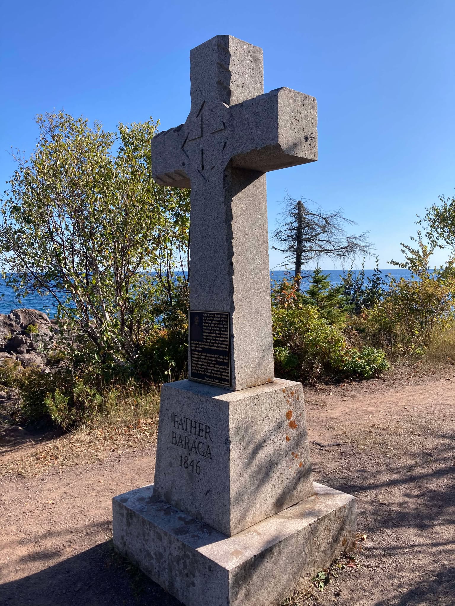
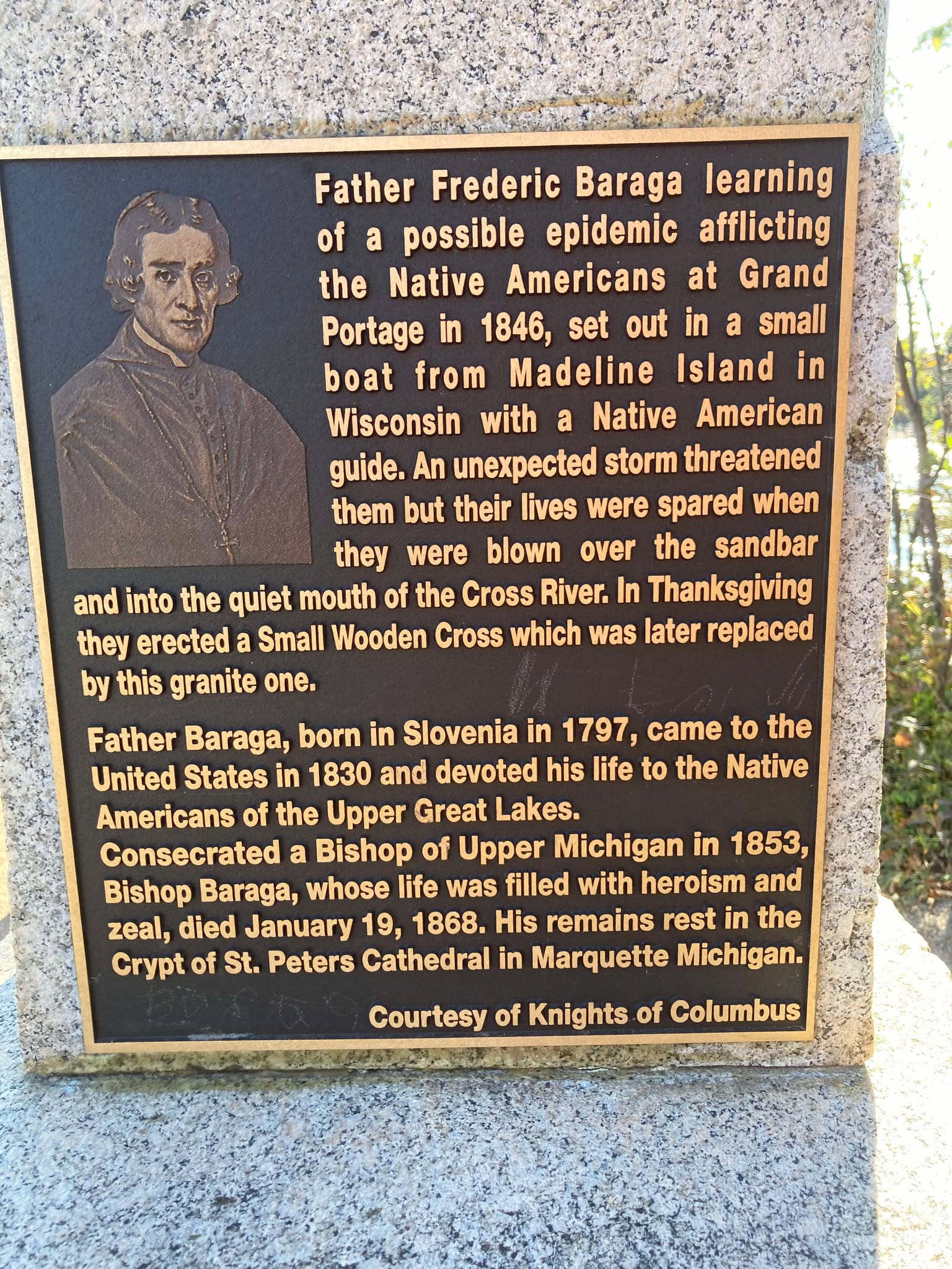
We learn from F. Baraga’s letter, written in October, 1845, that he intended to go to Grand Portage, Minn., the next fall to build a church there. It is, therefore, highly probable that he made that trip in the fall of 1846. He first went to La Pointe, where, no doubt, he spent some time attending to the spiritual wants of the good people. He then engaged a half-breed Indian, named Louis Gaudin, to go with him to Grand Portage. They had but a small fishing boat with a mast and sail, without keel or centre-board. Such a boat might do on a river or small lake, but would be very unsafe on a large lake, where it would easily founder or be driven lake a cork before the wind. The boat was but eighteen feet long. When they started from La Pointe, the people laughed at them for attempting to make the journey. They said it would take them a month to make the voyage, as they would have to keep close to the shore all the way, going first west some seventy miles to the end of the lake and then, doubling, turn northward, coasting along the northern shore of Lake Superior. this would make the distance about two hundred miles, perhaps even more.
However, Father Baraga and his guide set out on their perilous journey. At Sand Island they awaited a favorable wind to cross the lake, which is about forty miles wide at that place. By so doing they would save from eight to one hundred miles, but would expose themselves to great danger, as a high wind might arise, whilst they were out on the open lake, and engulf their frail bark.
They set sail on an unusually calm day. Father Baraga steered and Louis rowed the boat. Before they got midway a heavy west wind arose and the lake grew very rough. They were constantly driven leeward and when they finally reached the north shore they were at least thirty miles east of their intended landing place, having made a very perilous sail of seventy miles during that day.
While in the height of the storm, in mid-ocean, it might be said, Louis became frightened and exclaimed in Chippewa to the Father, who was lying on his back in the boat, reciting his office in an unconcerned manner: “Nosse, ki ga-nibomin, gananbatch” – Father, perhaps we are going to perish!” The Father answered quietly: “Kego segisiken, Wizon” (Chippewa for Louis) – “Don’t be afraid, Wizon; the priest will not die in the water. If he died here in the water the people on the other shore, whither we are going, would be unfortunate.”
When nearing the north shore the danger was even greater than out on the open water, for there were huge breakers ahead. Louis asked the Father whither to steer, and, as if following a certain inspiration, F. Baraga told him to steer straight ahead for the land. Through a special disposition of Divine Providence watching over the precious life of the saintly missionary, they passed through the breakers unharmed and ran their boat into the mouth of a small river, heretofore unnamed, but now called Cross River.
1859 PLSS detail of trees at the mouth of “Cross River”.
Full of gratitude for their miraculous escape, they at once proceeded to erect a cross. Hewing a tree in a rough manner, they cut off the top as far up as they could reach, and taking a shorter piece, they nailed it cross-wise to the tree. “Wizon,” said the Father, “let us make a cross here that the Christian Indians may know that the priest coming from La Pointe landed here.” The cross was, it is true, unartistic, but it was emblem of their holy faith and it gave the name, Tchibaiatigo-Sibi, “Cross River,” to the little stream where they landed.
They arrived none too soon. Ascending an eminence and looking out on the immense lake they saw that the storm was increasing every moment; high waves with white caps, which would surely have engulfed their little bark. They landed about six o’clock in the evening. Having spent the night there, they continued their journey next day, and in two days arrived at Grand Portage, having made the whole journey in three days. May we not think with Louis Gaudin that their safe passage across the stormy lake, and their deliverance from a watery grave, was due to a special intervention of Divine Providence in favor of the saintly missionary?

Missionary Labors of Fathers Marquette, Menard and Allouez, in the Lake Superior Region by Rev. Chrysostom Verwyst of Bayfield, 1886.
In 1667 Father Claude Allouez, S. J., then stationed at the mission of the Holy Ghost at the head of Chequamegon Bay, made the voyage across the lake from Sand Island. He made the voyage in a birch-canoe with three Indians. He remarks that they paddled their canoe all day as hard as they could without intermission, for fear of losing any of the beautiful calm weather they had. It took them twelve hours to make the trip across. The Father was then on his way to visit some Christian Indians residing at Lake Nipigon – “Animibigong” in Chippewa. For the particulars of this journey we refer the reader to “Missionary Labors of Fathers Marquette, Allouez, and Menard in the Lake Superior Region.”
The following narrative is not to be found in any of Baraga’s published letters, but the writers has it from the mouth of trustworthy persons, among whom is Father Chebul, a countryman of F. Baraga, who was stationed at Bayfield for many years. We will give the account, as we have it from Rev. F. Chebul.
Francois Newago, Sr. is the “man named Newagon” from Madeline Island, as his children were still young teenagers then.One time F. Baraga was going to Ontonagon in company with an Indian half-breed in the month of March or April. At that season of the year the ice, though thick, becomes honey-combed and rotten. Some say that Baraga’s companion was a man named Newagon. They went on the ice at La Pointe Island. As the walking on the sandy beach would have been very fatiguing and long, they determined to make straight for Ontonagon over the ice. By so doing they would not only have better walking, but also shorten their way a great deal.
A strong southwest wind was blowing at the time, and the ice, becoming detached from the shore, began drifting lakeward. After they had traveled for some time, they became aware of what hat happened, for they could see the blue waters between them and the shore. Newagon became greatly alarmed, for almost certain death stared them in the face. Had the wind continued blowing in the same direction, the ice would have been driven far out into the lake and broken up into small fragments. They would surely have perished.
To encourage the drooping spirit of his companion, F. Baraga kept telling him that they would escape all right and that they must trust in God, their loving Father and Protector. He also sang Chippewa hymns to divert Newagon’s attention and calm his excitement. Finally the wind shifted and blew the field of ice back towards the shore.
1847 PLSS detail of brownstone points, village, cross, and trailhead at the mouth of Iron River.
“Cadotte Point, near Union Bay“
appears to be located at what is now Silver City at the mouth of Iron River and eastern trailhead to the Porcupine Mountains.Michel Cadotte, Sr. ran a trading post by the Old French Fort on Madeline Island around 1800 and smaller stations scattered along the Wisconsin / Michigan shoreline of Lake Superior. Cadotte first worked for the British North West Company and later the American Fur Company after The War of 1812.They landed near Cadotte Point, near Union Bay, a short distance from Ontonagon, which they reached that same day. “See,” said the missionary to his companion, “we have traveled a great distance and have worked little.” The distance from La Pointe to Ontonagon is about sixty or seventy miles by an air line. Had they been obliged to walk the whole distance around the bend of the lake, it would probably have taken them two or three days of very hard and fatiguing traveling. So what at first seemed to threaten certain death was used by God’s fatherly providence to shorten and facilitate the saintly priest’s journey.
United States. Works Progress Administration:
Chippewa Indian Historical Project Records 1936-1942
(Northland Micro 5; Micro 532)
Reel 1, Envelop 3, Item 5
BISHOP BARAGA’S TRIP TO ONTONAGON
As related by William Obern to John Teeple.
Francois Belanger, Sr.
and Elizabeth (Gordon) Belanger. The Belanger Settlement was founded by their son Frank Belanger, Jr. and Elizabeth (Morrow) Belanger.
The journey I am about to describe is taken from the many experiences of Bishop Baraga, which were related to me by my grandfather. It deals with a journey made at an almost impossible time for ice travel on any of the Great Lakes, and portrays the important part the elements can play in a man’s life, for good or bad, for weal or for woe, as well as Bishop Baraga’s unfaltering confidence in Divine Providence.
The season of the year in which this incident took place was in the spring – along in April. Bishop Baraga and his faithful guide, Louis Gordon, started from LaPointe enroute to Ontonagon, Michigan, a distance of some eighty or ninety miles from LaPointe, straight across as the crow flies over the frozen water of Lake Superior. Dogs were used to a very large extent in those days for the purpose of transportation.
On account of the prevailing soft weather, the ice on the lake was not very solid, and with the right kind of wind, a general break-up was apt to occur at any time. In this instance, when the Bishop and his guide were about ten miles from LaPointe a south-west wind began to blow, increasing in velocity with each passing hour. The ice broke away from the shore, and began drifting outward into the open waters of Lake Superior, carrying its passengers with it. The guide, seeing the danger, suggested to the Bishop that they land on one of the islands, but the Bishop told him not to worry and to keep going in the direction of Ontonagon; that with the help of God they would reach their destination in safety.
With the coming of night the wind increased, and the two travelers were drifting out into the open waters with considerable speed. Soon the mainland was lost to view, and the guide knew that to remain on the ice mean ultimate death by freezing or drowning, but it was too late to do anything now. They had passed up the opportunity of getting off.
The missionary told Louis to look out for the dogs, and after taking a lunch, he wrapped himself up and went to sleep. He advised the guide to do likewise. The guide wrapped himself up, but he did not sleep. He kept constant vigil; about midnight the wind changed, coming from the opposite direction.

Detail of Porcupine Mountains, Iron River and Ontonagon River on the Map of the Mineral Lands Upon Lake Superior Ceded to the United States by the Treaty of 1842 With the Chippeway Indians, 1845.
The guide woke Bishop Baraga, telling him that the wind had changed. The priest asked his guide from what direction it was blowing, and upon being told that it was coming from the north-east remarked, “It is just what I hoped for and suspected.” He again told his guide to lie down and go to sleep, but the guide fearing that the plate of ice they were on might break up, would not sleep. They began to drift back almost in the same direction they had come, and when daylight came the outline of the Porcupine Mountains could be plainly seen in the distance. They were traveling at a very high rate of speed, and about mid afternoon they landed on the south shore of Lake Superior, one mile from Ontonagon, their destination.
“There,” said the bishop after they got off the ice and stepped on to the mainland, “this is just what I expected.”
At the time of this narrative, Ontonagon was a small settlement of Indians with but a few white men, who were engaged in the fur trade with the Indians and represented the American Fur Company.
* According to the description furnished by the guide, the piece of ice they were on was about one hundred by two hundred feet.
United States. Works Progress Administration:
Chippewa Indian Historical Project Records 1936-1942
(Northland Micro 5; Micro 532)
Reel 1, Envelop 3, Item 6
Cross River
ORIGIN OF THE NAME
Related by William Obern
To John Teeple.

Ojibwe, Activist, Priest
The Life of Father Philip Bergin Gordon, Tibishkogijik
by Tadeusz Lewandowski, 2019.
The story I am about to relate deals with an incident of one of the many experiences of Bishop Baraga. The narrative was related to me by my grandmother, Elizabeth Bellanger, who before her marriage was Elizabeth Gordon. She was a blood relative of Father Philip Gordon. The Gordon family consisted of the parents; sons, John, Louis and Antoine, and daughters My grandmother (Elizabeth) and Angelique.
Louis Gordon acted as the guide and all-around servant of Bishop Baraga, the missionary priest. The latter had a very large territory to cover; the northern and southern shores of Lake Superior, thence to the Dakotas and down to the waters known as Chippewa River, which emptied into the Mississippi below St. Paul.
Louis Gordon, the guide, (my grand-uncle) told of many of the experiences he had on these trips with Bishop Baraga. In speaking of my grand-uncle, Louis Gordon, I wish to state first, upon my honor as a gentleman, that he was a Christian in every sense of the word; he never took a drink of intoxicating liquor in his life; and never used profane language.
The stories related to me by my grandmother I well remember, and coming from a man like my grand-uncle, I believe them.
One day Bishop Baraga and his guide, Louis Gordon, started from LaPointe, on the western end of Lake Superior, near the place now known as Bayfield, on the shore of the lake, and about twenty-five miles from the present city of Ashland. At the time of this incident there were no white settlements to speak of at the western end of Lake Superior and the “head of the lakes” region. Bayfield, Washburn, Ashland, Superior and Duluth did not exist in those days. There were few white men among the Indians, and those few represented the American Fur Company. A few, mostly Frenchmen, had in former years settled in Minnesota and Wisconsin.
As formerly stated the trip started from LaPointe. It was to be made by water, and the boat used by the missionary and his guide, from the description given, could not have been more than 16 or 18 feet long. It was just large enough to accommodate the Bishop and his guide and to take care of their camping equipment, and although small, it came out the victor in many storms, proving itself quite seaworthy. These voyagers had a make-shift sail, which furnished them power when the wind was fair, probably a blanket which was raised on a pole; but in calm weather, or when the seas became too rough, the craft was usually propelled with oars. Wind and weather conditions in those days controlled lake travel largely, and when the lake became too rough and the seas too choppy, the voyageurs usually made a landing in some bay or stream outlet.
In this instance, the missionary and his guide were headed for Grand Marias, on the north shore of Lake Superior, a distance of fifty or fifty-five miles from the group of islands known as “Apostle Islands.” Leaving LaPointe, it was necessary for them to cross Lake Superior, traveling directly North. In the event of a severe storm, there is, of course, no place for shelter in the open waters of Lake Superior, and when once started it was necessary for them to continue their voyage until they reached Grand Marias, the point of their destination.
When the Bishop and his guide were about to leave the Apostle Islands, Louis Gordon, the guide, said to Bishop Baraga: “No-say,” (meaning father in Chippewa), “it would not be safe for us to cross the lake in this small boat today. The wind is from the south-west, and it is getting stronger. The lake will become very rough, the seas high, and I am afraid we may perish if we venture out in this wind. We had better not leave this island today, or else follow the south shore around to the end of the lake, so we can find a place to land should the seas become too rough.”
Bishop Baraga replied, “My son, have faith in God. Across that lake my Indians are waiting they must be expecting me, and it is my duty to get there as soon as possible. It would be a waste of time for us to go along the south shore, then along the north shore from the St. Louis River to Grand Marias, when we can cross here and save many miles of hard rowing and precious time. We will trust in God and make the crossing in safety.”
So, Louis Gordon, having unbounded faith in the Bishop, obeyed him, and they began their voyage across the lake, notwithstanding the fact that the wind was increasing in fury and the seas becoming higher and rougher with each passing moment. After they got into the open waters, the guide had considerable difficulty in manning the boat and keeping it from being swamped by the breaking seas. He stood up, and turning to Bishop Baraga said, “No-say, we will never reach the shore.” The Bishop was sitting at the stern of the boat, reciting his breviary. “Louis,” he said, “do not lose faith in God; fear not, He is with us.” The guide was kept busy in keeping the boat in its course, and bailing it out, to prevent it from being filled as the white caps would break over it. He headed it to a point west of Grand Marias in order that he might be better able to ride the crest of the seas, praying and hoping that when they reached the shore, which he hoped would be before dark, they would find a place to land in safety.
I wish to state here that I have seen the north shore of Lake Superior. After leaving Duluth, going east along the north shore, one will find a very rugged shore, ledges of rock from 20 to 200 feet in height standing perpendicularly along the shore line. In these rock ledges are great caves that have been fashioned by angry waves of Lake Superior during centuries. To fully appreciate this story it is well for the reader to know a little concerning the dangers of Lake Superior. Salt-water sailors who have been on the five oceans prefer to be on the ocean in a storm rather than on Lake Superior. The fact that Lake Superior is more dangerous than the oceans is conceded by sailors generally, particularly in the fall of the year. In the ocean, the billows are longer with great spaces between them; while on Lake Superior they are short, choppy, and heavy; and create much more hazard.
Night overtook the missionary and the guide before they reached the north shore; the wind became stronger and the billows higher. The only light they had to guide them was the distant glimmer of the stars, and the guide was able to keep his course by keeping his craft nosed in the direction of the North Star.
After many hours of hard pulling on the oars, the guide knew that they were reaching the shore because he was familiar with the shoreline, and knew that the noise which was all but deafening was created by the breakers dashing against the rock-bound shore.
The guide said to his companion, “No-say, we are nearing the shore, but I am sure we are many miles from Grand Marias. There is no river known in this region and on account of the precipitous formation of the shore line, we have no place to land in safety in this storm.” Bishop Baraga answered, “My son, do as I say, and we will make a landing in safety.” The guide obeyed. His hand were blistered; his strength was leaving his body, but he managed to keep up his struggle against the angry seas. The back-wash created by the billows dashing against the perpendicular rocks of the shore-line made conditions more perilous. The guide said, “Father, there is nothing but certain death ahead of us. We cannot survive this storm.” The noise was so great that it was impossible for the two voyagers to hear each other without shouting, though they were only fifteen or sixteen feet apart; but the Bishop simply said, “Louis, keep going straight ahead.”
Much water had entered their little boat, and it was coming in faster now that they were nearing the ledges of rocks, and the seas, augmented by the back-wash, were becoming rougher, so that destruction seemed imminent. Then amid the tumult and tossing of the boat upon the choppy seas, the boat was suddenly driven from the rough sea into tranquil waters, seemingly guided by some supernatural power. The guide knew that the craft was not being directed by his efforts, and that they were nearing the shore with each sweep of the waves. To his amazement, the boat grounded, and by feeling the depth of the water with his oar he knew that they were in shallow water, but he was unable to determine whether they were in a cave or at the mouth of some stream.
“Father,” Louis cried delightedly, “it seems to me that we are in a cave or at the mouth of some stream, because by feeling around with my oar I can feel a current coming from the land direction.” The missionary then told him to take out their bundle, and light the lantern so that they could see where they were and explore their surroundings.
After lighting the lantern, they made a survey of their surroundings and found that they were at the mouth of a large stream. They climbed out of the river and to higher ground, and there made their camp for the night.
Cross River Historical Marker
Photo by Brian Finstad, 2024.
The following morning, Bishop Baraga told his guide that they would stay there that day, that they would construct and erect a cross in token of thanksgiving to God for his help and guidance to safety. So, all that day they worked. They cut down some large cedar trees and erected a large cedar cross, which they set up on the shore at the mouth of the stream. The next morning Bishop Baraga and his guide went down to the site of the cross they had erected, and again offered thanks to God for their safe deliverance. The missionary told his guide: “Hereafter this stream shall be known as “Cross River”. It has been thus known from that time on.
About twenty or twenty-five years ago, a large number of people from Duluth, Superior, and other towns and cities in the Lake Superior region, regardless of creed, made a trip to Cross River and erected a substantial cross there in place of the old cedar cross set up by Bishop Baraga and his guide, Louis Gordon, in thanksgiving to God for the wonderful guidance and loving care of his servants who landed safely at the mouth of this stream after such a perilous voyage.
Bishop Baraga stopped at Superior on their way back from the North Shore. They did not venture another lake-crossing. This zealous Lake Superior Chippewa Indian Missionary died at Marquette, Michigan, on January 19, 1868.
Cross River Historical Marker
Photo by Brian Finstad, 2024.
Wisconsin Territory Delegation: Saint Croix Falls
April 28, 2016
By Amorin Mello
A curious series of correspondences from “Morgan”
… continued from La Pointe.

The Daily Union (Washington D.C.)
“Liberty, The Union, And The Constitution.”
August 27, 1845.
EDITOR’S CORRESPONDENCE.
—
(From our regular correspondent.)
FALLS, ST. CROIX, W. T., Aug. 7, 1845.
We left La Pointe on the afternoon of the day on which my last letter was dated. We had about 70 miles (English,) or 63 of French voyageur’s miles, to travel westward on the lake, before reaching the Brulé river, which we were to ascend for 75 miles, to make the portage to the St. Croix; the latter river being, from its source to the Mississippi river, including the Lake St. Croix at its mouth, about 300 miles long – thus making a journey before us of about 445 miles to reach the Mississippi. To La Pointe we had already coasted from Sault St. Marie, including the curves, bends, bays, &c , with the entire circuit of Keweena point, the distance of at least 500 miles. The two added together, give 945 miles of travel, in open boats by day, and under tents by night, with the exception of the three miles portage between the two rivers. We left the Sault on the 4th July, and reached this place within 50 miles of the Mississippi, making the whole time consumed one month and about three or four days, by the time we will have reached the “father of waters.”

Detail of the shoreline between La Pointe and the Bois Brulé River from Map of the Mineral Lands Upon Lake Superior Ceded to the United States by the Treaty of 1842 With the Chippeway Indians.
~ Wisconsin Historical Society
The distance, in a direct line, from the head of the bay opposite La Pointe, to the portage at the head of the Brulé, by land, is only 80 miles; while by the lake and river, it is about 145. The whole distance, in a direct line, by land, from La Pointe to the falls of St. Anthony, or to the mouth of the St. Peter’s, does not exceed, by the Indian trail alluded to, over 200 miles.
The first day we left La Pointe we were only enabled to reach Raspberry river, a small stream emptying into the lake 15 miles west of La Pointe, inside the group of islands.
We first encountered a prodigious thick fog, with a head wind. We had no sooner landed and raised our tent, than a thunder-storm, with a heavy rain, burst upon us. The voyageurs, as is their custom, had puled the bark canoes out of the water, and turned them over, placing provisions and other articles under them for shelter. The Indians, in travelling with their canoes, invariably pull them out of the water at night, turn them bottom upwards, and in bad weather, sleep under them; as our voyageurs (especially Jocko, our Indian voyageur) did on the night in question. In such cases, they turn water like the roof of a house. We had, late in the afternoon, doubled some frowning sandstone cliffs alluded to in my other letter, with the grottoes, caves, and excavations wrought out near the water’s edge, by the combined action of the waves and frost. Another high sandstone promontory still lay just ahead of us, which Ribedoux, our head man, said extended for six miles without affording a landing-place for a boat.
Next morning we found a severe gale blowing from the north-northeast, accompanied with rain. This compelled us to remain where we were till about 3 or 4 o’clock in the afternoon, when we set out. The wind had died away, but the sea was running very high, over which our canoes danced along at a great rate – riding them, however, like swans. The heaviest rolls would be mounted and slid over with as much ease as though the canoes were feathers, as they were propelled forward by the oars and paddles of our skillful voyageurs.
One canoe being small, only admitted of the use of paddles. The larger craft allowed a pair of oars to be used in front, while a paddle was employed in the stern. The usual plan of working canoes is to have only two persons to attend to one canoe. They are always steered with a paddle. One voyageur seats himself in the bow; while another does the same thing in the stern – the baggage, provisions, passengers, &c., being stored amidships, low in the hull. Thus arranged, the men apply their paddles with great skill, driving the canoe forward at a pretty rapid speed.
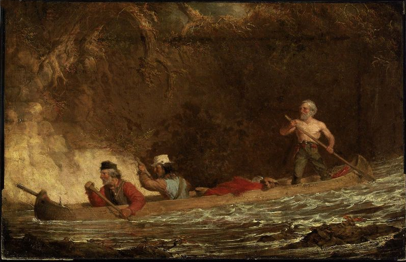
The Voyageurs by Charles Deas, 1846.
~ Commons.Wikimedia.org
The Indians display a deal of skill in the construction of their bark canoes. Their hulls have great symmetry of form; and, under careful handling, which the Indians perfectly understand and practise, they are very light and very strong.
The birch bark, from which they are principally made, is found of excellent quality on the shores and tributaries of Lake Superior, and is extensively used by the Indians for building their lodges, &c., as well as for canoes. In the latter application, the inside of the bark is exposed to the water and weather; while, in the former case, the outside of the bark is turned to the weather. Their lodges are of a hemispherical shape, with an opening at the top for the escape of smoke, with a door opening on one side of them, before which a blanket is usually suspended. The floor of the lodge, with the wealthier class, is usually covered with fine large richly-colored rush mats, on which the Indians recline or sit like Turks on them. The men, when at home, do little else than recline on the mats and smoke, while the squaws and half-grown children perform all the necessary manual labor. If an Indian brings in game or fish, he throws it down near his lodge, and troubles himself no more about it; or, if it be troublesome to carry, he leaves it in the woods, returns to the lodge, and sends his squaw for it.
The females among the Indians invariable exhibit the most modest and retiring deportment – equally as much so, I have thought, as is seen or met with among the most civilized whites. Neither males nor females, when you enter their villages or lodges, ever fix upon you that rude glare, or gaze, which white people often do upon the sudden appearance of a stranger. The usual salutation of the Chippewa, on meeting you, is “Bojour, bojour, bojour,” at the same time extending his hand to you in friendship. And if there are fifty men in company, they will all do the same thing. The exclamations they use is a corruption of the French salutation of “bon jour,” “good day;” or, in English parlance, “how d’ye do.”
The Indians are very fond of bathing and swimming, and they do not consider it the least indelicate for all sexes to bathe at the same time in the immediate vicinity of each other. I am told, on such occasions, the females wear dresses prepared for the purpose. The men also are partly clad.
“There are indications that Granville served as a teacher in a school unrelated to ABCFM on or near the Mackinaw Island from the fall of 1834 to the fall of 1835. His first connection with ABCFM dates from September 1835, and he was officially appointed by ABCFM as a missionary assistant some time in 1836. Granville took a leave between July 1837 and June 1838, then returned to La Pointe with his newly wed wife, Florantha nee Thompson. After one unsuccessful pregnancy, Florantha had two healthy daughters, in October 1842, and March 1844. Granville and Florantha retired from the mission in the summer of 1846.”
~ The Sproats at La Pointe: From pages of the Missionary Herald, Boston
I was told by Mr. Grote, who has resided at the Presbyterian mission at La Pointe for some 10 or 12 years, that the Indians, during long peace, and when little surrounds them of a nature to arouse or excite their energies, become, in general, very lethargic, and sink apparently (from ennui) into premature old age, few of them attaining to the years of advanced life. Among the chiefs I saw at La Pointe, was an old man of sixty. His hair was quite gray. He was introduced to me by a friend, at his own request. He wanted to know where I was from, and whether I had been sent to carry off the Indians. He was told that I had come on no such errand, but merely to visit and see the country, and that I was a “medicine man,” a “mushkiwinini:” this announcement put me on a very friendly footing with him. He bore a strong resemblance to Robert Dale Owen, the lecturer.
I was told by Mr. Grote that this old chief retained very strong predilections in favor of the British; that he frequently spoke of the good old times when they received fine presents and cheap goods from their great father, the King over the water; and that he annually paid a visit to the Hudson Bay Company’s trading-post at Fort William, or at the Sault, and received presents to some small amount. he nevertheless professed much friendship for the Americans.

“Mainland sea caves from the water.”
~ Apostle Islands National Lakeshore
We left Raspberry river between 3 and 4 p.m., and passed one among the most picturesque cliffs of sand-stone it was our lot to see during the voyage. It spread along the shore for 6 or 7 miles, varying in height from 50 to 100 feet. Its base was carved into holes and grottoes of every variety of form, into which the heavy rolls of the waves were pitching with a rumbling and heavy sound; while the white spray flew in foaming whiteness about the outward rocks. Making a beach near dark at the bottom of the bay, beyond the cliffs, we landed and camped. Early next morning we were again under way. In the afternoon we passed four Indian canoes loaded with Indians bound for La Pointe. They were from Fond-du-Lac.
Making Cranberry river, we found Capt. Stanard and his party of voyageurs, who had preceded us from La Pointe, and were bound for Fond-du-Lac, had stopped for dinner. We concluded to land at the same place for the same purpose.
We were told by Capt. S that he had, on his way, visited an encampment of Indians from Fond-du-Lac, who stated that the Chippewas at that place were laboring under a good deal of excitement. It seemed that two Indians of that place had been on a visit to the falls of St. Croix, where liquor was freely sold to the Indians; that one of the Indians and a white man quarrelled about a dog; that the latter mauled and beat the former most unmercifully, when the other Indian attempted to interfere, whom the white man attacked and commenced beating also. The last Indian thereupon stabbed the white man in the breast with a knife, the point of which struck a bone and glanced. The white man then drew a pistol, and fired it at the Indian, wounded him severely in the thigh. The Indians then left the falls, and returned to Fond-du-Lac highly incensed, and swearing vengeance against the whites; saying their relations numbered thirty warriors, who would aid them, if necessary, in seeing justice done. They also said that, some time ago, a Sioux Indian had killed a Chippewa, and that the whites did nothing with him for it. When the brother of the deceased Chippewa went over to St. Peter’s, and killed the Sioux, the whites had taken up two Chippewas, and had them in jail, which they thought very hard of. It was also said that sometimes, when the Chippewas left their homes to go to the payment, the Sioux followed them, with a view of annoying and harassing them in the rear.
Captain S. said that he had intended to visit the falls of the Brulé, to fish for trout; but that, owing to these reported difficulties, he should proceed directly to Fond-du-Lac. It seems that the whole foundation of the troubles on the St. Croix, with the Chippewas, has grown out of the circumstance of grog-shops having been opened at different places along that stream – say one at the falls, another at Wolf river, eighteen or twenty miles above, and a third at the Rising Sun, twenty-five miles above the falls – by low and villanous white men, or half-breeds engaged in their service. It seems that, some years since, the Chippewas made a treaty, ceding all their lands to the United States, south of a line running due south some fifty miles from the extreme west end of Lake Superior, and from that southern point due west to the mouth of Crow-wing river, on the Upper Mississippi, cutting nearly through the centre of Mille Lake in its course. There is a proviso in the treaty of cession, which authorizes the Indians to remain in the occupancy of the ceded territory till it is wanted by the government. I understood Mr. Hays (the Indian agent at La Pointe) to say that he had no power to stop the sale of ardent spirits to the Indians, by the white squatters in the ceded country. These drunken outrages, if not put a stop to on the St. Croix, will, ere long, lead to serious and disastrous consequences. The Indians and whites will soon become embroiled in a border “guerrilla” war, and the poor savages, in the end, be butchered and driven out of the country – all, too, growing out of the cupidity of a few rascally men, who aim to cheat and rob the Indians of their last blanket, by selling them the hellish poison of whiskey. What is the massacre of innocent whites, with the ruin and degradation of Indians, to them, provided they can turn a penny by dealing out rum!! Mr. Hays lives almost too remote from the St. Croix to prevent these outrages, even if he had the power. But it does seem to me, that the Indian agent at St. Peter’s, who resides within a day or two’s journey of these outrages, might do something to prevent them.
With due vigilance and firmness on his part, it would appear probable, at least, that Indian murders would not transpire within gun-shot of his agency at St. Peter’s.
The War Department should adopt immediate measures to break up the sale of whiskey to the Indians on the St. Croix, and other parts of that ceded territory, or very serious consequences will follow. One poor Indian from Fond-du-Lac, on a visit to one of the grogeries on the St. Croix, was made beastly drunk, who, in his helplessness, fell with his face on the fire; having his cheek, with one eye, awfully disfigured and burnt; leaving his whole visage an object of loathing and disgust for life.
As our course to the Mississippi lay along the St. Croix, directly through the whiskey district, the reports of present and prospective difficulties were not very pleasant. We nevertheless made up our minds to persevere, and meet whatever might happen.
Negwanebi (Quill)
Wazhashkokon (Muskrat’s Liver, aka Pítad in Dakota);
Noodin (Wind).
Towards sunset, we made the mouth of the Brulé, where we found about thirty Chippewa Indians with two or three chiefs encamped, who were on their way to La Pointe; from Leech Lake and Mille Lake. They belonged to the band denominated “pillageurs,” so nicknamed from their alleged propensity to steal small matters. We landed on the opposite side of the river to their camp, on a flat – the stream being about twice as wide as the Tiber in good water at Washington. We were soon joined by Captain Stanard, whose men pitched his tent near ours, and cooked supper by the same fire. We had scarcely kindled our camp fire, before the chiefs of the “pillageurs” manned their canoes, and came over, crying out, as they came up; “Bojour,” “bojour,” and giving us their hands, which we accepted. They looked poor and dirty, some of whom were nearly naked. They said they had nothing to eat, and were very hungry, and wished us to give them some flour, which we complied with. No sooner did the rest find out we were dispensing “farine,” as the French voyageurs term it, than the whole [posse?] kept coming over in instalments, till we had the whole camp upon our hands – women, children, and all.
We gave them all round about a pint of flour, from Captain S.’s and our own supply, and then gave them to understand we wished them to retire to their own side of the river; they all left us, except some old chiefs, who were privileged to remain, and appeared desirous of smoking their pipes before our fire, and talking over news with Jocko, our Indian voyageur, and one of Captain S.’s half-breeds.
In their camp opposite – out of joy, I suppose, over the flour we had given them – they commenced beating a drum, and singing in a most wild and monotonous manner, which they kept up till near ten p.m., when all became silent. We all fell fast asleep; and when I awoke next morning, calling the hands for an early start, all was quiet in the Indian camp. Captain Stanard prepared to depart at the same time, and before sunrise he was off to Fond-du-Lac, and we to the Mississippi. Whatever the “pillageurs” may have done elsewhere, we will do them the justice to say that they stole nothing from us; for next morning, on packing up, we missed nothing whatever. Many of them had pleasing and honest countenances, whatever else may be said about them.

Detail of the Bois Brulé River (aka “Wissakude [Wisakoda] or Burnt Wood”) and the portage over the Great Divide (a continential divide between the Lake Superior Basin and Missisippi River Basin) to the Saint Croix River from Hydrographical Basin of the Upper Mississippi River from Astronomical and Barometrical Observations Surveys and Information by Joseph Nicolas Nicollet, 1843.
~ David Rumsey Map Collection
At many places the rapids were so powerful, and the channel so crooked and narrow, that the voyageurs had to wade in the water frequently to their waist, and push the canoes forward with their hands. Sometimes their feet would slip from the spurs of trap-rock boulders, and they would go into holes of deep water, nearly to their arm-pits or chins.
We worked forward in this way over rapids, for about thirty miles; and having passed three portages, around which we had to walk and carry our baggage, with still the fourth and last severe one before us, we finally struck up a camp near the head of the third portage, where all were sufficiently fatigued to sleep most soundly. At this last portage rapid, there appeared in the bottom of the river a mass of trap crossing it, over which the water fell two or three feet nearly perpendicular.
We were off next morning early, after having examined the bottoms of our canoes, and patched and gummed the leaky places with birch bark and Canada balsam-tree rosin. The small canoe had to be patched and pitched two or three times, having been punched with holes by the rocks.
“In consideration of the cession aforesaid, the United States agree to make to the Chippewa nation, annually, for the term of twenty years, from the date of the ratification of this treaty, the following payments.
1. Nine thousand five hundred dollars, to be paid in money.
2. Nineteen thousand dollars, to be delivered in goods.
3. Three thousand dollars for establishing three blacksmiths shops, supporting the blacksmiths, and furnishing them with iron and steel.
4. One thousand dollars for farmers, and for supplying them and the Indians, with implements of labor, with grain or seed; and whatever else may be necessary to enable them to carry on their agricultural pursuits.
5. Two thousand dollars in provisions.
6. Five hundred dollars in tobacco.
The provisions and tobacco to be delivered at the same time with the goods, and the money to be paid; which time or times, as well as the place or places where they are to be delivered, shall be fixed upon under the direction of the President of the United States.
The blacksmiths shops to be placed at such points in the Chippewa country as shall be designated by the Superintendent of Indian Affairs, or under his direction.
If at the expiration of one or more years the Indians should prefer to receive goods, instead of the nine thousand dollars agreed to be paid to them in money, they shall be at liberty to do so. Or, should they conclude to appropriate a portion of that annuity to the establishment and support of a school or schools among them, this shall be granted them.”
“Whereas the whole country between Lake Superior and the Mississippi, has always been understood as belonging in common to the Chippewas, party to this treaty; and whereas the bands bordering on Lake Superior, have not been allowed to participate in the annuity payments of the treaty made with the Chippewas of the Mississippi, at St. Peters July 29th 1837, and whereas all the unceded lands belonging to the aforesaid Indians, are hereafter to be held in common, therefore, to remove all occasion for jealousy and discontent, it is agreed that all the annuity due by the said treaty, as also the annuity due by the present treaty, shall henceforth be equally divided among the Chippewas of the Mississippi and Lake Superior, party to this treaty, so that every person shall receive an equal share.”
Towards noon, we began to find the rapids less frequent and difficult, till we finally came into a beautiful low bottom, or meadow land, of elm trees, which lasted us for many miles; when, towards night, we again passed some severe rapids, and then entered a long lake of irregular width, formed by the expansion of the river at this point – in no case being more than from seventy-five to one hundred yards wide, with generally a swamp on one side, and considerable sloping pine hills or bluffs on the other. We found this river, and especially the lake part of it, to be very full of brook trout, some of which we caught, and found them not only beautiful in color, but most excellent to eat; they were continually jumping above the water. During this day and yesterday, we met several parties of half-breeds and Indians on their way to La Pointe. On inquiring of them about the fight at the falls, and the difficulties at St. Peter’s, they gave us the most favorable accounts of the quiet and peaceful disposition of the Indians, and said that we might travel just where we pleased, without the least danger whatever. At any rate, there was one guarantee of their good conduct for a few weeks to come – and that was the forthcoming payment at La Pointe, to which they go up with as much eagerness as the Jews of old did to the Passover. Any serious disturbance at the present time, or probably at any time, would jeopard the receipt of their annuity, and likely lead to their expulsion from the country. Besides, at the payment they have an opportunity of laying their numerous grievances before the father, who has to promise them to speak for them in the ear of the great father at Washington. So matters progress from one year to another, till many grievances of a minor or trivial nature are forgotten.
We camped on a sloping pine ridge, on the east side of the lake part of the river, about 7 p.m. We found all the nights on the Brulé cool and pleasant. The water throughout we found as cold as the best mountain spring-water.
We continued our ascent at an early hour next morning, and by noon found our little stream very much diminished in size and volume of water, dwindling first into a small creek, and afterwards into a mere meadow-brook, nearly choked up by the hanging and interlocked alder bushes, the limbs of which we had to push out of our way to enable us to pass. The little river on this swampy meadow-land also became very crooked. In going a mile, we very often had to traverse the meadow nearly a dozen times.

“Recreation of a voyageur carrying two 90 lb packs of fur across a portage to avoid rapids or move to another river.”
~ Saint Croix National Scenic Riverway
About half-past 2 p.m., however, we arrived at the portage, or the place where we were to take our canoes out, transport them, and afterwards their contents, on our backs, across hill-sides, and over the summit of one or two pine, sand, and pebble hills, about one hundred and fifty feet above the level of the swamp in which the St. Croix and Brulé head. The two rivers are said to have a common origin in one spring. But the swamp, in which they both head, is no doubt full of springs – some running one way and some running another. This swamp is wide, extending from one river to the other, nearly north and south. On the east side of this swamp, and parallel with it, are found the range of pine hills by the sides, and over the summits of which the portage path crosses. Still to the east of this short range of hills, is a small lake, which empties into the river Brulé at some distance below the portage, called by the voyageurs White-fish lake. Near the head of streams of the St. Croix river is Upper St. Croix lake, to which our portage path descended at the northeast corner, descending to it down the southern side of the hills spoken of, being three miles from the place of debarkation on the Brulé. The sources of these rivers are laid down in Mr. Nicollet’s map as being nine hundred feet above the Atlantic. They are also said to be two hundred and seventy-five feet above the level of the lake; but I am inclined to believe that they are higher than stated – especially so above the level of the lake, if the high land we crossed be included in the estimate. Most of the maps are in error about the geography of this part of the country, both with regard to the heading of the rivers; as well as to their size and course.
The course of the Brulé is from south-southeast to north-northwest from the portage to the lake, being comparatively a small river. The course of the St. Croix, from its head to the Mississippi is south-southwest, and is by no means so crooked low down as represented. It is so large, for fifty or seventy-five miles above the falls, as to compare very favorably with the Ohio; which, at some points, it much resembles. It, and its tributaries, have a deal of fine pine timber growing along its banks; a good deal of which has been cut, to supply the mills below. Mr. Nicollet’s map, which is generally very correct, lays down hills between the waters of the Brulé and St. Croix, where none exist. I believe he did not visit the portage in person, but relied on the information of voyageurs.
It was an agreeable reflection to know, when standing on the highest point of hills on the portage, that we could overlook the course of one river sweeping away to the north, on its vast journey to the Gulf of the St. Lawrence; while to the south were seen the waters of the St. Croix, just gathered into a pretty, quiet lake, from its conglomerate of springs near by about to speed its waters to the Mississippi, and down it to the Gulf of Mexico! and when once there, perchance, gathered in the Gulf stream, and be again wafted by it to the banks of Newfoundland, where it may again unite with the water of its kindred Brulé!
What a wonderful continent is this of ours! What cast rivers and lakes intersect it! To appreciate their lengths, magnitude, scenery, &c., they must be travelled over to be understood. In June, I was at the Falls of Niagara; in a few days I shall probably be at the Falls of St. Anthony – passing from one to the other by water, with the exception of three miles!
Having, on August the 2d, succeeded in getting everything over the portage, including canoes, luggage, &c.; and it being towards sundown; we concluded to camp, and get ready for an early start next morning. Sunday morning, the 3d of August, found us descending the beautiful upper lake St. Croix, bordered in the distance with rolling pine-hills.
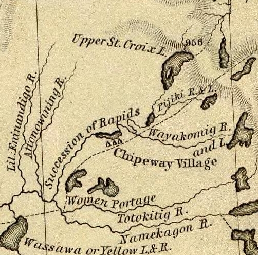
Detail of the upper Saint Croix River, Brule Bog portage, and “Chipeway Village” from Hydrographical Basin of the Upper Mississippi River From Astronomical and Barometrical Observations Surveys and Information by J.N. Nicollet, 1843. Also shown is the Grand Footpath (long dotted line) between Chequamegon Bay and Saint Anthony Falls.
~ David Rumsey Map Collection
We soon began to meet large parties of Indians in their canoes, bound to La Pointe, to be present at the payment. As Mr. Hays (the Indian agent at La Pointe) had told us that he expected the Rev. Mr. Ely, who had charge of a Presbyterian missionary station on the Percagaman, or Snake river, to be over at the payment, and thought it probable that we might meet him; and learning that some of the Indians we met were from Snake river, I asked them if they knew whether Mr. Ely had left. They told me he had, and that he was at his camp down the river, which we would soon reach.
We continued on, amidst fields of wild rice in full bloom, which covered the lake for acres upon acres on each side of the channel. This wild rice (rizania aquatica) is of great importance to the Indians, who gather large quantities of it when ripe, in autumn, for their winter food. Its soft stem and watery roots are immersed about 2 to 2½ feet under water, while the blades, head, and stalk reach about a foot to a foot and a half above water. In flowering, its heads present a singular appearance. Its pistils, or grain part of the flower, are clustered on a long, sharp-pointed spicular, terminating in a sharp cone at the very head of the stalk; while the pollen appears attached to the stalk below the head.
Why could not this rice be sown and cultivated in the lakes of western New York and in New England? Besides the value of the grain for poultry and various other purposes, its tops or blades would make the richest and sweetest fodder for cattle. I chewed the blades, and found them tender, and as sweet as the tender blades of green corn. The experiment might be worth the trial.

Reverend Edmund Franklin Ely.
~ Duluth Public Library
About the middle of the afternoon we reached the first rapids in descending the St. Croix, now contracted from a lake into a narrow river, strewed here and there with black boulders of trap. We here had the pleasure of finding Mr. Ely encamped on the west bank of the river, who had remained still all day, as it was Sunday. He had in company with him the Rev. Mr. Rosselle, a young clergyman from Ogdensburg, New York, to whom he introduced me. Mr. Rosselle informed me that he had been to the falls of St. Anthony, from whence he had gone on a steamboat “Still-water,” at the head of the lower Lake St. Croix, and from thence to the missionary station on the Pergacaman, or Snake river, where he concluded to accompany the Rev. Mr. Ely to La Pointe, and be present at the Indian payment. From La pointe he expected to make his way home by the Sault St. Marie, Mackinac, &c. Mr. Ely had some Indians along with him, who were evidently attached to the mission. He said the success of the mission had been interfered with, to some extend, by the dread in which the Chippewas held the Sioux in that part of the country; that in constant fear of their natural enemy, they disliked making permanent settlements and to improve them. After some other general conversation, we continued our journey over rapids, till near night, when we camped (as was often the case) on an old Indian camping-ground, and saw lying about us dog bones, on the meat of which the Indians had feasted. An innumerable swarm of horseflies surrounded our tent and camp-fire, which the voyageurs at first mistook for bumble bees, whose nest, they conceived, they had disturbed, and, for fear of being stung, they fled; but, on ascertaining they were merely noisy flies, they came back again.
We made an early start next morning, to resume our descent over rapids dashing over trap and granite boulders. We met a half-breed and his wife, who had a keg of whiskey in his canoe. They were going to La Pointe, where Mr. Hays suffers no liquor to land. The man offered to treat my voyageurs, one of whom was known to him. I consented that they might take one dram each, but no more. This being given them, we thanked him, and proceeded on our journey. About noon, we passed the last severe rapids, and the mouth of a large tributary from the east, called the Macagon, about 100 miles above the falls, and within 50 miles of Snake river.

Detail of the Saint Croix River with tributaries Snake River and Kettle River from Hydrographical Basin of the Upper Mississippi River From Astronomical and Barometrical Observations Surveys and Information by J.N. Nicollet, 1843. Also shown is the Grand Footpath (long dotted line) between Chequamegon Bay and Saint Anthony Falls.
~ David Rumsey Map Collection
The St. Croix, from this point down, became a larger, more beautiful, and more interesting stream. The bottoms, too, became wide and rich, but subject to inundation at very high water. The stratified red sandstone was seen to skirt the margins of the river, all along the rapids; while boulders of trap and granite were strewn over the centre of the channel. But, as we approached Kettle and Snake rivers, we began to notice the appearance of white sandstone on the shores of the river, which continued to appear till near the falls, and again rose in high cliffs below them, and continued to the Mississippi. At night, we camped on a high pine bluff on the right bank of the river, a large swamp being on the opposite side. Here we were nearly devoured by mosquitoes, and were glad to make our escape next morning without breakfast – intending to stop and cook at a place, if possible, less infested by them; which we did, on the pebbly beach of an island.
We had a showery forenoon, but continued our journey. We met with several long rapids, and, passing Kettle river, reached the mouth of Snake river, about 10 a.m. – where we found a body of Indians encamped, going to La Pointe. We exchanged some meal for some fish, and gave an old woman some sugar for a sick child. Then, wishing them a “bon voyage,” we put off. About 25 miles above the falls, we passed Sunrise river, with splendid and extensive bottom-land opposite to it on the left bank, lying high and dry above high-water mark.
The next place we made was Wolf river, about 18 or 20 miles above the falls. Here we found a rude village, on a rich piece of land, settled by half-breeds, Indians, and a Frenchman or two. They had lots of liquor, and offered to sell me some; but I declined to purchase, or to let my voyageurs buy any; and, though late in the afternoon, moved for some 8 or 10 miles further, and camped just within the first rapid or two, at the commencement of the falls. From the head of the rapids to the falls is 9 miles.

Detail of Saint Croix Falls with tributaries Sunrise River (“Memokage”) and Wolf Creek (“Attanwa”) from Hydrographical Basin of the Upper Mississippi River From Astronomical and Barometrical Observations Surveys and Information by J.N. Nicollet, 1843. Also shown is the Grand Footpath (long dotted line) between Chequamegon Bay and Saint Anthony Falls.
~ David Rumsey Map Collection
~ Fifty Years in the Northwest by William H. C. Folsom, 1888, page 87.
We reached the falls next morning to breakfast, where I made the acquaintance of Mr. Purinton, to whom I bore a letter of introduction, and found him a very clever and enterprising man. He has done more to develop this part of the country, and to enhance its value and settlement, than any other man in it. The falls afford a splendid water-power, fully equal to that yielded by the falls of the Merrimac at Lowell. Mr. Purinton is the proprietor, and has a saw-mill running with five saws, in separate frames. His logs come down the St. Croix.
There is a trap formation in place, crossing the river at the falls, obliquely from northwest to southeast. It is lost a short distance to the northwest of the river, but runs off in a range of 20 miles to the southeast of the falls. It differs a good deal from the trap-formation on Lake Superior. It is of a bluish and lighter color than the trap on the lake in the high perpendicular cliffs of this stone, which faces the river at, and for some little distance below the falls, may be seen strong indications of a columnar structure in its form; while in the trap on Lake Superior, the same rock is uniformly amorphous in its form.
Besides, the trap on Lake Superior appears uniformly to have had an upheaval through red sandstone; while that at the falls has been borne up through white sandstone, very distinct in its character from the red sandstone of the lake. It is probable, therefore, that there is no continuous connexion or homogeneousness of character between the trap-rock of the falls, and that on Lake Superior; and that they may have been raised at far different and distinct periods. Be this as it may, however, I found the trap at the falls of St. Croix to give very favorable indications of the existence of copper ore. Mr. Purinton gave me some very interesting specimens of the ore found in the vicinity of his mill.
While rambling about the falls, I discovered, also, one or two very fine mineral chalybeate springs.

Detail of the Saint Croix River from the Falls to the head of Saint Croix Lake (Stillwater, Minnesota) from Hydrographical Basin of the Upper Mississippi River From Astronomical and Barometrical Observations Surveys and Information by J.N. Nicollet, 1843. Also shown is the Grand Footpath (long dotted line) between Chequamegon Bay and Saint Anthony Falls (Minneapolis, Minnesota.
~ David Rumsey Map Collection
Having paid off my voyageurs at the falls, and sent them back in one of the canoes, I prepared to descend the river to the head of the lake, or to Stillwater, in the other; which I reached next day. There is a saw-mill at this place, and two others between it and the falls – all being turned by streams which enter the river on one side or the other. At Stillwater, a town not quite a year old, there is a tavern, two stores, a blacksmith-shop, one lawyer, one doctor, no preacher, no schoolmaster, no justice of the peace or mayor, one saw-mill, no school, a large cool spring, and a very pretty place for the town to grow on. We here met the steamboat Lynx, on which we took passage, after disposing of my canoe.
The land on the west side of Lake St. Croix is beautiful all the way to the Mississippi, and is fast settling up. This beautiful sheet of water is 22 miles long, and from one and a half to two miles wide.
I am, very respectfully and sincerely, yours,
MORGAN.
To be continued in Copper Harbor Redux…
Wisconsin Territory Delegation: La Pointe
April 23, 2016
By Amorin Mello
A curious series of correspondences from “Morgan”
… continued from The Copper Region.
The Daily Union (Washington D.C.)
“Liberty, The Union, And The Constitution.”
August 9, 1845.
La Pointe, Lake Superior
July 26, 1845
To the Editor of the Union:

View of La Pointe, circa 1843.
“American Fur Company with both Mission churches. Sketch purportedly by a Native American youth. Probably an overpainted photographic copy enlargement. Paper on a canvas stretcher.”
~ Wisconsin Historical Society
I have just time to state that, having spent five days at Copper Harbor, examining the copper mine, &c. at that place, and having got everything in readiness, we set off for this place, along the coast, in an open Mackinac boat, travelling by day, and camping out at night. We reached this post on yesterday, the 25th instant. We have now been under tents 21 nights. In coming up the shore of the lake, we on one occasion experienced a tremendous rain accompanied with thunder, which wetted our things to a considerable extent, and partly filled the boat with water.
On our way we spent a good part of a day at Eagle river, and examined the mine in the process of being worked at that place, but found it did not equal our expectations.
We also stopped at the Ontonagon, the mineral region bordering which, some fifteen miles from the lake, promises to be as good as any other portion of the mineral region, if not better.
I have not time at present to enter fully into the results of observations I have made, or to describe the incidents and adventures of the long journey I have performed along the lake shore for the distance of about 500 miles, from Sault Ste. Marie to La Pointe. There are many things I wish to say, and to describe, &c.; but as the schooner “Uncle Tom,” by which I write, is just about leaving, I have not time at present. I must reserve these things for a future opportunity.
I am, very respectfully,
Your obedient servant,
MORGAN.
P.S. – I set off in a day or two for the Mississippi and Falls of St. Anthony, via the Brulé and St. Croix rivers.
Yours, &c., M.
The Daily Union (Washington D.C.)
“Liberty, The Union, And The Constitution.”
August 25, 1845
EDITOR’S CORRESPONDENCE
—
[From our regular Northern correspondant.]
La Pointe, Lake Superior,
July 28, 1845.

Map of the Mineral Lands Upon Lake Superior Ceded to the United States by the Treaty of 1842 With the Chippeway Indians.
~ Wisconsin Historical Society
In what I said in my last letter of this date, in relation to the extent, value, and prospects of the copper-mines opened on Lake Superior, I had no wish to dampen the ardor, would the feelings or injure the interest of any one concerned. My only wish is to state facts. This, in all cases, I feel it my duty to do; although, in so doing, as in the present case, my individual interest suffers thereby. Could I have yielded to the impulses and influences prevailing in the copper region, I might have been greatly benefited in a pecuniary point of view by pursuing a different course ; but, knowing those whom I represented, as well as the public and the press for which I write, wanted the truth, the whole truth, and nothing but the truth, I could do nothing less than make the statement I did. Previous to visiting the country, I could, of course, know nothing of its real character. I had to judge, like others, from published reports of its mineral wealth, accompanied with specimens, &c., which appeared very flattering; but which, I am now convinced, have been rather overdrawn, and the mineral region set out larger and richer than it really is. The authors of the reports were, doubtlessly, actuated by pure motives. They, no doubt, had a wish, in laying down the boundaries of the mineral region, so to extend it as to leave out no knoll or range of trap-rock, or other formation, if any indicative of mineral deposites, which usually appear in connexion with them, occurred.
I consider, in conclusion, that the result thus far is this: that the mines opened may possibly, in their prosecution, lead to rich and permanent veins; and probably pay or yield something, in some cases, while exploring them. But, however rich the specimens of one raised, at present there is nothing in them, geologically speaking, that indicates, conclusively, that they have reached a vein, or that the mines will continue permanently as rich as they are at present. This would be my testimony, according to the best of “my knowledge and belief,” on the witness’s stand, under oath.
“The remarkable copper-silver ‘halfbreed’ specimen shown above comes from northern Michigan’s Portage Lake Volcanic Series, an extremely thick, Precambrian-aged, flood-basalt deposit that fills up an ancient continental rift valley.”
~ Creative Commons from James St. John
That the region, as before said, is rich in copper and silver ores, cannot be denied. And I think the indications that veins may or do exist somewhere in great richness, are sufficiently evident to justify continued explorations in search of them, by those who have the means and leisure to follow them up for several years. To find the veins, and most permanent deposites, must be the work of time; and as the season is short, on Lake Superior, for such operations, several years may be necessary before a proper and practical examination can be made of the country.
The general features of Lake Superior are very striking, and differ very much in appearance from what I have ever met with in any other part of the continent. The vastness and depth of such a body of pure fresh cold water so far within the continent, is an interesting characteristic. When we consider it is over 900 feet deep, with an area of over 30,000 square miles, and yet that, throughout its whole extent, it presents as pure and as fresh-tasted water as though it were taken from a mountain brook, the question naturally arises, Where can such a vast supply of pure water come from? It is true, it has great many streams flowing into it, but they are nearly all quite small, and would seem to be wholly inadequate to supply such a vast mass of water, and preserve it in such a state of purity. The water supplied by most of the rivers is far less pure than that in the lake itself. East of Keweena point, we found the water of the rivers discolored, being tinged by pine and other roots, clay, &c., often resembling the hue of New England rum. Such rivers, or all combined, would seem to be inadequate to supply such a vast quantity of pure clear water as fills this inland ocean!
~ United States Geological Survey
It is possible that this great lake is freely supplied with water from subterranean springs opening into it from below. The river St. Mary’s also seems inadequate, from its size, to discharge as much water as comes into the lake from the rivers which it receives. In this case, evaporation may be so great as to diminish the water that would otherwise pass out at it.
As relates to tides in the other lakes, we have nothing to say; but, as far as Lake Superior is concerned, we feel assured, from observation, as well as from the reports of others upon whom we can rely, that there are tides in it – variously estimated at from 8 to 12 inches; influenced, we imagine, by the point of observation, and the season of the year at which such tides are noticed.
The Voyageurs (1846) by Charles Deas.
~ Commons.Wikimedia.org
What strikes the voyageur with the most interest, in the way of scenery, is the wild, high, bold, and precipitous coast of the southern shore, for such much of the whole distance between Grand Sable and La Pointe, and, indeed, for some distance beyond La Pointe ; the picturesque appearance of which often seemed heightened to us, as on a clear morning, or late afternoon, or voyageurs would conduct our boat for miles near their bases. Above us, the cliffs would rise in towering heights, while the bald eagle would be soaring in grand circular flights above their summits; our voyageurs, at the same time, chanting in chorus many of their wildest boat songs, as we glided along on the smooth and silent bosom of the lake. I have heard songs among various nations, and in various parts of the world; but, whether it was the wild scenery resting in solemn grandeur before me, with the ocean-like waste of water around us, which lent wilderness to the song, I never listened to any which appeared to sing a verse in solo, and then repeat a chorus, in which the whole crew would join. This would often be continued for several miles at a time, as the boat glided forward over smooth water, or danced along over the gentle swells of a moderate sea; the voyageurs, at the same moment, keeping time with their oars.
Jean Baptiste, our pilot, had an excellent voice, full, loud, and strong. He generally led off, in singing; the others falling in at the choruses. All their songs were in French, sometimes sentimental or pathetic, sometimes comic, and occasionally extempore, made, as sung, from the occurrences of the preceding day, or suggested by passing scenes.
The Chippewa Indians are poor singers; yet they have songs (such as they are) among them; one of which is a monotonous air repeated at their moccasin games.
Stereographic view of a moccasin game, by J. H. Hamilton, 1880.
~ University of Minnesota Duluth
Next to the love of liquor, many of the Indians have a most unconquerable passion for gambling. While at La Pointe, I had an opportunity of seeing them play their celebrated moccasin game. They were to the number of two, or three aside, seated on the ground opposite to each other, which a blanket spread out between them, on which were placed four or five moccasins. The had two lead bullets, one of which was made rough, while the other remained smooth. Two f the gamesters were quite young men, with their faces painted with broad horizontal red and blue stripes, their eyelashes at the same time being dyed of a dark color. They played the game, won and lost, with as much sang froid as old and experienced gamblers. Those who sat opposite, especially one of them, was much older, but no means a match, at the time of my visit, for the young rascals, his antagonists. One takes the balls in his hands, keeps his eye directly on the countenance of the opposite party, at the same time tossing the balls in his hands, and singing, in a changing voice, words which sound somewhat like “He-he-hy-er-he-he-hy-er-haw-haw-haw-yer. He-he-hy-er,” &c. During which he keeps raising, shifting, and putting down the moccasins, till, finally, he raises his hands, having succeeded in concealing the balls under two of the moccasins, for which the other proceeds to search; and if he succeeds, on the first trial, in finding the rough ball, he wins. Then he takes the balls to hide, and commences singing himself. If he fails, he loses; and the first party repeats the song and the secretion of the balls. They hold in their hands small bundles of splinters of wood. When one loses, he gives to the winner so many sticks of wood. A certain number of them gained by any one of the party, wins the game. When I saw them, they had staked up their beads, belts, garters, knife-cases, &c. Their love of gaming is so strong, as to cause them to bet and lose everything they possess in the world – often stripping the last blanket from their naked backs, to stake on the game. It is said that some Indians acquire so much dexterity at this game, that others addicted to it refuse to play with them. In playing the game, they keep up a close watch on each other’s eyes, as being the best index to the movement of the hands. The song is repeated, no doubt, to diver the attention of the antagonists.
Among other peculiarities of Lake Superior, and one of its greatest recommendations, is the abundance and superiority of its fish, consisting of trout of large size, white fish, siskomit, ( a species of salmon,) and bass. The trout and siskomit are the finest and noblest fresh-water fish I ever saw. Almost every day we could catch trout by trailing a hook and line in the water behind out boat. In this way we caught one fine siskomit. Its meat, when fresh-cooked, we found about the color of salmon. The fish itself is about as heavy as a common-sized salmon, but less flat, being more round in form.

Detail of “The 12 Apostles” from Captain Jonathan Carver’s journal of his travels with maps and drawings, 1766.
~ Boston Public Library
If you will look at a map of Lake Superior, you will find, near its upper end, a labyrinth of islands, called by the early French voyageurs, of whom P. Charlevoix was one, (a Jesuit,) “the Madelaine islands.” They are sometimes called “the Twelve Apostles.” The largest island is now generally known as “the Madelaine island” – being the largest of the group. Just inside, and near its southern extremity, at the head of a large, regular bay, with a sandy beach, with an open and gently-rising scattered pine and spruce land in the rear of the beach, stands La Pointe – one of the most pleasant, beautiful, and desirable places for a residence on Lake Superior, and the very place where Fort Wilkins should have been placed, instead of its present location, which must be conceded, by every impartial person, to be among the very worst that could have been selected on the whole lake.
The garrison at Copper harbor, located, as it is, upon the rocky surface of trap conglomerate, affording a surface so scantily supplied with soil amidst masses of pebbly rock and trap fragments as to be wholly unfit for any sort of cultivation whatever, is altogether out of place. It is wholly inaccessible by land, and can only be reached by water in summer. It is at a spot where Indians usually never passed within forty miles of it, till since its occupation.
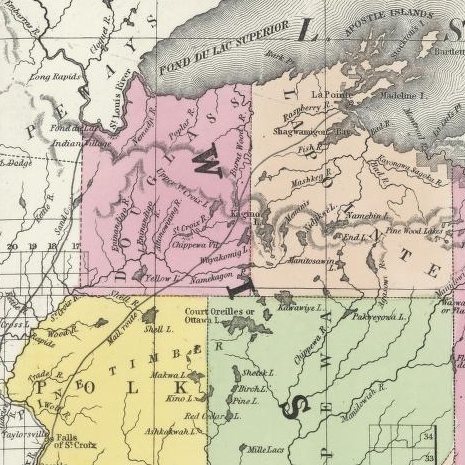
Detail of the Indian trail or “mail route” between La Pointe and St. Anthony Falls.
~ A new map of the State of Wisconsin, by Thomas, Cowperthwait & Co., 1850
The very next Congress should direct its prompt removal to La Pointe. Here, from the foot of the bay in front of the Madelaine island, there is an Indian trail, connecting La Pointe with St. Anthony’s Falls, and over which the mail is carried in winter by voyageurs on foot. La Pointe is the favorite resort of the Indians. Their lodges, in villages, bark canoes, &c. are found here the year round.
They delight to paddle and sail their canoes about the beautiful bays, harbors, &c. of these islands, employing their time in canoe building, hunting, fishing, &c. At every annual payment of their annuities, they flock to La Pointe in great numbers. Not only is that section of the great Chippewa nation sharing in the annuities brought together, but large parties of the same tribe, who receive no annuity, come at the same time from the British possessions to the north of Pigeon river. The Chippewas, called the “Pillageurs,” (so called from their thievish propensities,) inhabiting the country about Mille and Leech lakes, also attend – to meet relations, to traffic , and, perhaps, to steal a little. The great advantage of a government outpost is felt in the moral effect it exercises over the Indians. I know of no place where this influence would be more decidedly and beneficially exerted than at La Pointe. here should be daily unfurled the “stars and stripes,” and the sound of the evening gun be heard over the beautiful bays, and along the shores of the Twelve Apostles, which the Indians would learn to reverence with little less respect than they do the voice of the Manitou – the guardian spirit of the mines, embowelled in the dark trap hills of the lake.
Here, too, is an exceedingly healthy place, a good soil, and every convenience for raising the finest potatoes, turnips, and every kind of garden stuff.

1856 oil painting of Doctor Charles William Wulff Borup, a native of Copenhagen, Denmark. Borup married Elizabeth Beaulieu, a Lake Superior Chippewa daughter of Bazil Hudon Beaulieu and Ogimaagizzhigokwe. Borup and his brothers-in-law Charles Henry Oakes and Clement Hudon Beaulieu were co-signers of the 1842 Treaty with the Chippewa at La Pointe. Borup and Oakes became the first bankers of Minnesota.
Dr. Borup, the agent for the American Fur Company, (who have an extensive trading-post at this place,) has a superb garden. In walking through it with him, I saw very fine crops of the usual garden vegetables growing in it. His red currant bushes were literally bent down beneath their weight of ripe fruit. His cherry-trees had also borne well. Gooseberries also succeed well. The doctor also had some young apple-trees, that were in a thriving condition. Poultry, likewise, does well. Mrs. B. had her yard well stocked with turkeys, geese, ducks, and chickens. There was also a good garden at the mission-house of the American board.
However infinitely better is such a place for a United States garrison than Copper harbor, located, as it were, on a barren rock, where no Indians are seen, unless induced to go there by the whites – where there is nothing to protect – where intercourse is cut off in winter, and food can only reach it in summer – where there is no soil on which to raise a potato or a cabbage. I can only say that a greater blunder, in the location of a military post, was probably never committed. And if made (of which I am assured it was not) by a military man, he ought to be court-martialed and cashiered.
The mouth of the Ontonagon river is a far better spot for the fort than Copper harbor. It has a good soil, and a beautiful site for a fort. Furthermore, the country between it and Fort Winnebago, on the Wisconsin river, is favorable to the construction of a military road, which ought, at no distant day, to be opened. Another road should be cut from Fort Snelling, near the falls of St. Anthony, to La Pointe. In cutting these roads, it would seem to me as if the United States soldiers themselves might be usefully employed.
~ FortWiki.com
While at Copper harbor, I frequently visited Fort Wilkins, in command of Captain Cleary, whom I consider in every way an ornament and an honor to the service. In the brief space of time he has been at this post, and with the slender materials at command afforded by the country, he has nevertheless succeeded in making an “oasis” in a wilderness. He has erected one of the neatest, most comfortable, and best-planned garrisons it has been my lot to enter on the western frontier. He keeps all in excellent condition. His men look clean, healthy, and active. He drills them daily, and keeps them under most excellent discipline. He seems to take both pleasure and ride in the service. He says he never has any difficulty with is soldiers while he can exclude ardent spirits from them, as he succeeds in doing here, notwithstanding the great number of visitors to Copper harbor this summer.
To all travellers who are interested in objects of leading curiosity, the character of the Indians they fall in with cannot fail to arrest a share of attention.
The Chippewas are the only Indians now met with from the Sault Ste. Marie and Mackinac, extending from thence west along the southern shore of Lake Superior, to Fond du Lac, and from thence, in the same direction, to the Mississippi river. Within the United States they extend over the country south from the British boundary, to the country low down on the St. Croix and Chippewa rivers. The same tribe extends from our boundary northwest of the lake, entirely around its northern shore on British territory, till they reach the Sault Ste. Marie, opposite the American shore. It is said this tribe, spread over such a vast tract of country, is a branch of the powerful race of the Algonquins. They are sometimes called O-jib-was. They do not exist as a consolidated nation, or strictly as a confederation of bands. The entire nation on both sides of the line is divided into a great number of bands, with a chief at the head of each, which not uncommonly go by his name, such as “Old Martin’s band,” “Hole in the Day’s band,” &c.
The chief’s son, especially if he exhibits the right qualities, is expected to succeed his father at the head of the band; but very frequently the honor is reached by usurpation. The whole nation, which widely differ in circumstances, according to the part of the country they inhabit, nevertheless all speak the Chippewa language, and have extensive connexion by marriage, &c. The bands inhabiting the southern shore of Lake Superior are by far the best of any others. Though polygamy still prevails among them, and especially among their chiefs, it is nevertheless said to be becoming less common, especially where they are much influenced by Catholic and other missions. While at La Pointe, an Indian wedding was consummated, being conducted according to the ceremonies of the Catholic church, and performed by the missionary priest of that persuasion stationed at the Pointe.
There is one trait of character possessed by the Chippewas, (if we except, perhaps, the band of “pillageurs,” who have a kind of “Bedouin Arab” reputation among their countrymen,) which, I am sorry to say, the whites do not possess in an equal degree – that is, “very great honesty.”
White men can travel among them with the most perfect safety as to life and property. I will venture to say, that a man may carry baskets filled with gold and silver, and set them down in Indian villages, or leave them lying where he likes, or go to sleep by them, with Indians encamped all around him, and not one cent will be touched. Such a thing as a house being broken open and robbed at a Chippewa Indian trading-post was never heard of – within between two and three years’ intercourse with them – in time of peace. Dr. Borup said he would not be afraid, if concealed to look on, to leave his store door open all night; and the fact alone of its being left open, might be made known to the Indians at the Pointe. He would expect to see no Indian enter the store, nor would he expect to lose anything; such was his confidence in their honesty!!
Last winter, flour at the Pointe rose to $40 per barrel. The poor Indians were nearly famished for bread, but were unable to purchase it at such a price. They knew the American Fur Company had a considerable lot in store, guarded by nothing stronger than a padlock, yet they never offered the least violence towards the company’s agents or store! Would white people have acted as honestly? The poor Indians, by nature honest, have too often known the whites by the wrongs inflicted upon them, which God can forgive, but time can never blot out! They are very superstitious, but not as basely and insanely so, but a great deal, as the Mormons, Millerites, and other moon-stricken sects among the whites. They believe in one Great and Good Spirit, or a Being who can at will inflict good or evil on mankind; and there’s an end of it. They often denominate the mysterious spirit of evil import the Manitou, making him to dwell in the wild hills, islands, grottoes, and caves of Lake Superior.
From these huge birds the Indians obtained their first knowledge of fire, which they kindled with fire-sticks. These mythical birds were the most powerful of the animal deities of the Indians of the woodlands and of the plains. When the weather was stormy they flew about high in the heavens. When they flapped their great wings, one heard the crashes of thunder, when they opened and closed their eyes flashes of lightning were seen. Some carried lakes of water on their backs, these slopped over and caused downpours of rain. Their arrows, or thunderbolts, were the eggs which they dropped in their flight. These shattered the rocks and set fire to the forests and prairies.
A Chippewa Indian hunter, who was carried away to his nest by a Thunderer, saved his life by killing one of the young birds and flying back to earth in its feathered hide.
In the Smoky Mountains, a wild and rugged region in the southwestern part of Bayfield County, was the home of Winneboujou (Nenebozho), the fabled hero of the Ojibwa Indians. This all-powerful manitou was a blacksmith, and had his forge on the flat top of the highest mountain. Here he shaped the native copper of the Lake Superior region into useful implements for his Indian children. Much of his work at his forge was done at night, and the ringing blows of his great hammer could be heard throughout the Brule Valley and Lake Superior region. The fire of his forge reddened the sky. When he was not busy at his forge he was away hunting or seeking other adventures. Many stories of the exploits of this giant manitou have been told by the Chippewa and other Wisconsin Algonquian tribes.”
~ Legends of the Hills of Wisconsin by Dorothy Moulding Brown; The Wisconsin Archaeologist, Volume 18, Number 1, 1937, pages 20-21.
At times, it is said, a peculiar noise issues from the Porcupine mountains, and from the high hills on the main land, both east and west of La Pointe, some distance off. It is said to resemble the distant discharge of ordnance, or thunder. At one time, they said it was so loud and frequent, that they mistook it for signal guns fired from the brig Astor, which they thought might be in distress, and actually sent out a boat in search of her.
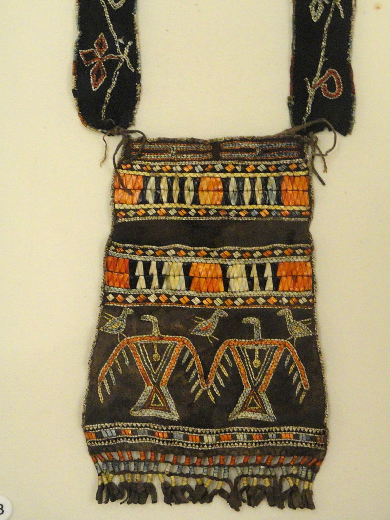
“Ojibwe shoulder pouch depicting two thunderbirds in quillwork, Peabody Museum, Harvard University.”
~ Commons.Wikimedia.org
These sounds the Indians believe to be the voice of the spirit “Manitou,” who guards the deposites of mineral wealth embowelled beneath the hills, and to whom any attempt made to dig them up, and carry them off, would be highly offensive, and followed by some kind of punishment. I have never yet heard of an Indian’s leading a white man to a locality of copper, or telling where he has found a piece when picked up!
Some have supposed that the noise in question arises from volcanic action; but, as no vibration is felt in the earth, and no other proof exists of such being the case, we are led to believe that the noise is produced by the lashing of the waves of the lake after a storm, as they are driven forward into the grottoes, caves, &c. of the tall sandstone cliffs, formed at their bases by the disintegrating effects of water and ice. Some distance east of La Pointe, about the Little Girl’s Point and Montreal river, as well as west of the same place, some fifteen or twenty miles, high red sandstone cliffs occur. At their bases, near the water’s edge, a great many curiously-shaped caves and grottoes appeared. In places, the sandstone had been so cut away, that only pillars remained standing at some ten or fifteen feet in the lake, from the top of which a high rude arch would extend to the main shore, and beneath which boats could easily pass. This was particularly the case near where the islands are parted with going west up the southern shore of the lake. Some caves, with small openings for mouths, run for a long distance back beneath the hills, expanding, likely, into large halls with high vaulted roofs, &c. After a storm, a heavy sea continues to roll into these grottoes and caverns, the waves lashing themselves against their sides and roofs – thus producing sounds resembling those heard at La Pointe, &c.
As the weather is generally calm after a storm, before the sea goes down, it is likely at such times these sounds are heard.
We had occasion to pass these places when a considerable sea would be on, close to the cliffs, and could hear the hollow heavy sounds of the waves as they broke into the caverns within the cliffs and hills. Every day, while we remained, parties of Indians continued to arrive, to be present at the payment.
We finally became prepared to leave for the Mississippi, having bought two bark canoes, and hired four new voyageurs – two for each canoe – one Indian, one half-breed, and two descendants of Canadian French; and, with a stock of provisions, we were ready to be off. From this place, I sent back three voyageurs to the Sault Ste. Marie, all that I hired to come as far as La Pointe. So, after paying our respects to Mr. Hays, our worthy Indian agent, and to Dr. Borup, (to both of whom I had borne letters of introduction,) and having many “bon voyages” heaped upon us by our friends and the friends of the voyageurs, we bade adieu to La Pointe.
You will not hear from me again till I reach the Falls of St. Croix.
I am yours, very truly, &c.
MORGAN.
To be continued in Saint Croix Falls…
Wisconsin Territory Delegation: The Copper Region
April 17, 2016
By Amorin Mello
A curious series of correspondences from “Morgan”
… continued from Copper Harbor.

The Daily Union (Washington D.C.)
“Liberty, The Union, And The Constitution.”
August 21, 1845.
EDITOR’S CORRESPONDENCE.
—
[From our Regular Correspondent.]
THE COPPER REGION.
La Pointe, Lake Superior
July 28, 1845.
Map of the Mineral Lands Upon Lake Superior Ceded to the United States by the Treaty of 1842 With the Chippeway Indians.
~ Wisconsin Historical Society
In my last brief letter from this place, I had not time to notice many things which I desired to describe. I have now examined the whole coast of the southern shore of Lake Superior, extending from the Sault Ste. Marie to La Pointe, including a visit to the Anse, and the doubling of Keweena point. During the trip, as stated previously, we had camped out twenty-one nights. I examined the mines worked by the Pittsburg company at Copper harbor, and those worked by the Boston company at Eagle river, as well as picked up all the information I could about other portions of the mineral district, both off and on shore. The object I had in view when visiting it, was to find out, as near as I could, the naked facts in relation to it. The distance of the lake-shore traversed by my part to La Pointe was about five hundred miles – consuming near four weeks’ time to traverse it. I have still before me a journey of three or four hundred miles before I reach the Mississippi river, by the way of the Brulé and St. Croix rivers. I know the public mind has been recently much excited in relation to the mineral region of country of Lake Superior, and that a great many stories are in circulation about it. I know, also, that what is said and published about it, will be read with more or less interest, especially by parties who have embarked in any of the speculations which have been got up about it. It is due to truth and candor, however, for me to declare it as my opinion, that the whole country has been overrated. That copper is found scattered over the country equal in extent to the trap-rock hills and conglomerate ledges, either in its native state, or in the form of a black oxide, as a green silicate, and, perhaps, in some other forms, cannot be denied;- but the difficulty, so far, seems to be that the copper ores are too much diffused, and that no veins such as geologist would term permanent have yet positively been discovered.

Detail of a Survey of Location No. 4 for the Pittsburgh & Boston Copper Harbor Mining Co. Image digitized by the Detroit Public Library Burton Historical Collection for The Cliff Mine Archeology Project Blog.
The richest copper ore yet found is that raised from a vein of black oxide, at Copper harbor, worked by the Pittsburg company, which yields about seventy per cent. of pure copper. But this conglomerate cementation of trap-rock, flint, pebbles, &c., and sand, brought together in a fused black mass, (as is supposed, by the overflowings of the trap, of which the hills are composed near this place,) is exceedingly hard and difficult to blast. An opinion seems to prevail among many respectable geologist, that metallic veins found in conglomerate are never thought to be very permanent. Doctor Pettit, however, informed me that he had traced the vein for near a mile through the conglomerate, and into the hill of trap, across a small lake in the rear of Fort Wilkins. The direction of the vein is from northwest to southeast through the conglomerate, while the course of the lake-shore and hills at this place varies little from north and south. Should the doctor succeed in opening a permanent vein in the hill of trap opposite, of which he is sanguine, it is probable this mine will turn out to be exceedingly valuable. As to these matters, however, time alone, with further explorations, must determine. The doctor assured me that he was at present paying his way, in merely sinking shafts over the vein preparatory to mining operations; which he considered a circumstance favorable to the mine, as this is not of common occurrence.
The mines at Copper harbor and Eagle river are the only two as yet sufficiently broached to enable one to form any tolerably accurate opinion as to their value or prospects.
~ Encyclopedia of the Earth
Other companies are about commencing operations, or talk of doing so – such as a New York, or rather Albany company, calling themselves “The New York and Lake Superior Mining Company,” under the direction of Mr. Larned, of Albany, in whose service Dr. Euhts has been employed as geologist. They have made locations at various points – at Dead river, Agate harbor, and at Montreal river. I believe they have commenced mining to some extent at Agate harbor.
One or two other Boston companies, besides that operating at Eagle river, have been formed with the design of operating at other points. Mr. Bernard, formerly of St. Louis, is at the head of one of them. Besides these, there is a kind of Detroit company, organized, it is said, for operating on the Ontonagon river. It has its head, I believe, in Detroit, and its tail almost everywhere. I have not heard of their success in digging, thus far; though they say they have found some valuable mines. Time must determine that. I wish it may be so.

Boston Mining Company stock issued by Joab Bernard in 1846.
~ Copper Country Reflections
From Copper harbor, I paid a visit to Eagle river – a small stream inaccessible to any craft larger than a moderate-sized Mackinac boat. There is only the open lake for a roadstead off its mouth, and no harbor nearer than Eagle harbor, some few miles to the east of it. In passing west from Copper harbor along the northern shore of Keweena point, the coast, almost from the extremity of Keweena point, to near Eagle river, is an iron-bound coast, presenting huge, longitudinal, black, irregular-shaped masses of trap-conglomerate, often rising up ten or fifteen feet high above water, at some distance from the main shore, leaving small sounds behind them, with bays, to which there are entrances through broken continuities of the advanced breakwater-like ledges. Copper harbor is thus formed by Porter’s island, on which the agency has been so injudiciously placed, and which is nothing but a conglomerate island of this character; with its sides next the lake raised by Nature, so as to afford a barrier against the waves that beat against it from without. The surface of the island over the conglomerate is made up of a mass of pebbles and fragmentary rock, mixed with a small portion of earth, wholly or quite incapable of cultivation. Fort Wilkins is located about two miles from the agency, on the main land, between which and the fort communication in winter is difficult, if not impossible. Of the inexcusable blunder made in putting this garrison on its present badly-selected site, I shall have occasion to speak hereafter.
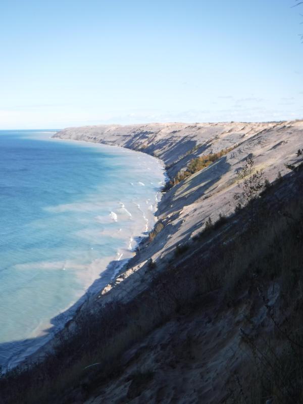
“Grand Sable Dunes”
~ National Park Service
In travelling up the coast from Sault Ste. Marie, the first 50 or 100 miles, the shore of Lake Superior exhibits, for much of the distance, a white sandy beach, with a growth of pines, silver fir, birch, &c., in the rear. This beach is strewed in places with much whitened and abraded drift-wood, thrown high on the banks by heavy waves in storms, and the action of ice in winter. This drift-wood is met with, at places, from one end of the lake to the other, which we found very convenient for firewood at our encampments. The sand on the southern shore terminates, in a measure, at Grand Sables, which are immense naked pure sand-hills, rising in an almost perpendicular form next to the lake, of from 200 to 300 feet high. Passing this section, we come to white sand-stone in the Pictured Rocks. Leaving these, we make the red sand-stone promontories and shore, at various points from this section, to the extreme end of the lake. It never afterwards wholly disappears. Between promontories of red stone are headlands, &c., standing out often in long, high irregular cliffs, with traverses of from 6, 7, to 8 miles from one to the other, while a kind of rounded bay stretches away inland, having often a sandy beach at its base, with pines growing in the forest in the rear. Into these bays, small rivers, nearly or quite shut in summer with sand, enter the lake.
The first trap-rock we met with, was near Dead river, and at some few points west of it. We then saw no more of it immediately on the coast, till we made the southern shore of Keweena point. All around the coast by the Anse, around Keweena bay, we found nothing but alternations of sand beaches and sand-stone cliffs and points. The inland, distant, and high hills about Huron river, no doubt, are mainly composed of trap-rock.

Detail from Map of the Mineral Lands Upon Lake Superior Ceded to the United States by the Treaty of 1842 With the Chippeway Indians.
~ Wisconsin Historical Society
Going west from Eagle river, we soon after lost both conglomerate and trap-rock, and found, in their stead, our old companions – red sand-stone shores, cliffs, and promontories, alternating with sandy or gravelly beaches.
Detail of the Ontonagon River, “Paul’s Cabin,” the Ontonagon Boulder, and the Porcupine Mountains from Map of the Mineral Lands Upon Lake Superior Ceded to the United States by the Treaty of 1842 With the Chippeway Indians.
~ Wisconsin Historical Society
The trap-rock east and west of the Portage river rises with, and follows, the range of high hills running, at most points irregularly, from northeast to southwest, parallel with the lake shore. It is said to appear in the Porcupine mountain, which runs parallel with Iron river, and at right angles to the lake shore. This mountain is so named by the Indians, who conceived its principal ridge bore a likeness to a porcupine; but, to my fancy, it bears a better resemblance to a huge hog, with its snout stuck down at the lake-shore, and its back and tail running into the interior. This river and mountain are found about twenty miles west of the Ontonagon river, which is said to be the largest stream that empties into the lake. The site for a farm, or the location of an agency, at its mouth, is very beautiful, and admirably suited for either purpose. The soil is good; the river safe for the entrance and secure anchorage of schooners, and navigable to large barges and keel-boats for twelve miles above its mouth. The trap range, believed to be as rich in copper ores as any part of Lake Superior, crosses this river near its forks, about fifteen miles above its mouth. The government have organized a mineral agency at its mouth, and appointed Major Campbell as agent to reside at it; than whom, a better selection could not have been made.
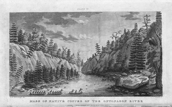
“Engraving depicting the Schoolcraft expedition crossing the Ontonagon River to investigate a copper boulder.”
~ Wisconsin Historical Society
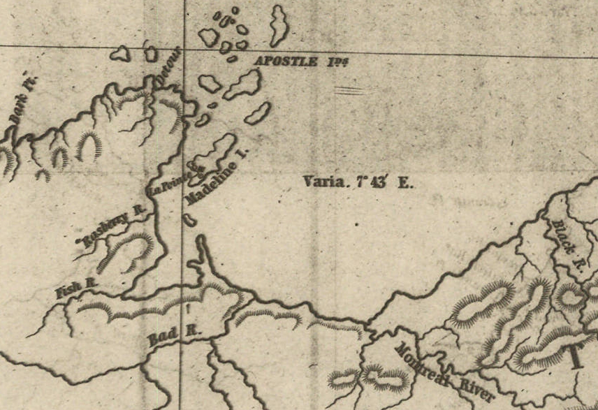
Detail of the Montreal River, La Pointe, and Chequamegon bay from from Map of the Mineral Lands Upon Lake Superior Ceded to the United States by the Treaty of 1842 With the Chippeway Indians.
~ Wisconsin Historical Society
The nearest approach the trap-rock hills make to the lake-shore, beyond the Porcupine mountain, is on the Montreal river, a short distance above the falls. Beyond Montreal river, to La Pointe, we found red-clay cliffs, based on red sand-stone, to occur. Indeed, this combination frequently occurred at various sections of the coast – beginning, first, some miles west of the Portage.
From Copper harbor to Agate harbor is called 7 miles; to Eagle river, 20 miles; to the Portage, 40 miles; to the Ontonagon, 80 miles; to La Pointe, from Copper harbor, 170 miles. From the latter place to the river Brulé is about 70 miles; up which we expect to ascend for 75 miles, make a portage of three miles to the St. Croix river, and descend that for 300 miles to the Mississippi river.

Painting of Professor Douglass Houghton by Robert Thom. Houghton first explored the south shore of Lake Superior in 1840, and died on Lake Superior during a storm on October 13, 1845. Chequamegon Bay’s City of Houghton was named in his honor, and is now known as Houghton Falls State Natural Area.
Going back to Eagle river, at the time of our visit, we found at the mine Mr. Henshaw, Mr. Williams, and Dr. Jackson of Boston, and Dr. Houghton of Michigan, who was passing from Copper harbor to meet his men at his principal camp on Portage river, which he expected to reach that night. The doctor is making a rapid and thorough survey of the country. This work he is conducting in a duplicate manner, under the authority of the United States government. It is both a topographical and geological survey. All his surveyors carry sacks, into which they put pieces of rock broken from every prominent mass they see, and carry into camp at night, for the doctor’s examination, from which he selects specimens for future use. The doctor, from possessing extraordinary strength of constitution, can undergo exposure and fatigue sufficient to break down some of the hardiest men that can be found in the West. He wears his beard as long as a Dunkard’s; has a coat and patched pants made of bed ticking; wears a flat-browned ash-colored, wool hat, and a piece of small hemp cord off a guard chain; and, with two half-breed Indians and a small dog as companions, embarks in a small bark, moving and travelling along the lake shore with great celerity.
Probably no company on Lake Superior has had a longer and harder struggle against adversity than the Phœnix. The original concern, the Lake Superior Copper Company, was among the first which operated at Lake Superior after the relinquishment of the Indian rights to this country in 1843. The trustees of this early organization were David Henshaw and Samuel Williams of Boston, and D. G. Jones and Col. Chas. H. Gratiot, of Detroit; Dr. Charles T. Jackson examined the veins on the property, and work was begun in the latter part of the year 1844. The company met with bad luck from the start, and, the capital stock having become exhausted, it has been reorganized several times in the course of its history.”
~ The Lake Superior Copper Properties: A Guide to Investors and Speculators in in Lake Superior Copper Shares Giving History, Products, Dividend Record and Future Outlook for Each Property, by Henry M. Pinkham, 1888, page 9.
We all sat down to dinner together, by invitation of Mr. Williams, and ate heartily of good, wholesome fare.
After dinner we paid a visit to the shafts at the mine, sunk to a considerable depth in two or three places. Only a few men were at work on one of the shafts; the others seemed to be employed on the saw-mill erecting near the mouth of the river. Others were at work in cutting timbers, &c.
They had also a crushing-mill in a state of forwardness, near the mine.
It is what has been said, and put forth about the value of this mineral deposite, which has done more to incite and feed the copper fever than all other things put together.
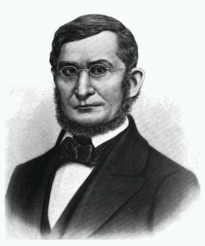
Professor Charles Thomas Jackson.
~ Contributions to the History of American Geology, plate 11, opposite page 290.
Dr. Jackson was up here last year, and has this year come up again in the service of the company. Without going very far to explore the country elsewhere, he has certainly been heard to make some very extravagant declarations about this mine,- such as that he “considered it worth a million of dollars;” that some of the ore raised was “worth $2,000 or $3,000 per ton!” So extravagant have been the talk and calculations about this mine, that shares (in its brief lease) have been sold, it is said, for $500 per share! – or more, perhaps!! No doubt, many members of the company are sincere, and actually believe the mine to be immensely valuable. Mr. Williams and General Wilson, both stockholders, strike a trade between themselves. One agrees or offers to give the other $36,000 for his interest, which the other consents to take. This transaction, under some mysterious arrangement, appears in the newspapers, and is widely copied.
Without wishing to give an opinion as to the value and permanency of this mine, (in which many persons have become, probably, seriously involved,) even were I as well qualified to do so as some others, I can only state what are the views of some scientific and practical gentlemen with whom I fell in while in the country, who were from the eastern cities, and carefully examined the famous Eagle river silver and copper mine. I do not allude to Dr. Houghton; for he declines to give an opinion to any one about any part of the country.
“The remarkable copper-silver ‘halfbreed’ specimen shown above comes from northern Michigan’s Portage Lake Volcanic Series, an extremely thick, Precambrian-aged, flood-basalt deposit that fills up an ancient continental rift valley.”
~ Shared with a Creative Commons license from James St. John
They say this mine is a deposite mine of native silver and copper in pure trap-rock, and no vein at all; that it presents the appearance of these metals being mingled broadcast in the mass of trap-rock; that, in sinking a shaft, the constant danger is, that while a few successive blasts may bring up very rich specimens of the metals, the succeeding blast or stroke of the pick-axe may bring up nothing but plain rock. In other words, that, in all such deposite mines, including deposition of diffused particles of native meteals, there is no certainly their PERMANENT character. How far this mine will extend through the trap, or how long it will hold out, is a matter of uncertainty. Indeed, time alone will show.
It is said metallic veins are most apt to be found in a permanent form where the mountain limestone and trap come in contact.
I have no prejudice against the country, or any parties whatever. I sincerely wish the whole mineral district, and the Eagle mine in particular, were as rich as it has been represented to be. I should like to see such vast mineral wealth as it has been held forth to be, added to the resources of the country.
Unless Dr. Pettit has succeeded in fixing the vein of black oxide in the side of the mountain or hill, it is believed by good judges that no permanent vein has yet been discovered, as far as has come to their knowledge, in the country!! That much of the conglomerate and trap-rock sections of the country, however, presents strong indications and widely diffused appearances of silver and copper ores, cannot be denied; and from the great number of active persons engaged in making explorations, it is possible, if not probable, that valuable veins may be discovered in some portions of the country.
To find such out, however, if they exist, unless by accident, must be the work of time and labor – perhaps of years – as the interior is exceedingly difficult, or rather almost impossible, to examine, on account of the impenetrable nature of the woods.
During our long and tedious journey, we were favored with a good deal of fine weather. We however experienced, first and last, five or six thunderstorms, and some tolerably severe gales.
Coasting for such a great length, and camping out at night, was not without some trials and odd incidents – mixed with some considerable hardships.
On the night before we reached La Pointe, we camped on a rough pebbly beach, some six or eight miles east of Montreal river, under the lea of some high clay cliffs. We kindled our fire on what appeared to be a clear bed of rather large and rounded stones, at the mouth of a gorge in the cliffs.

Topographic map of the gorge in the cliffs at Little Girl’s Point County Park.
~ United States Geological Survey
Next morning early, the fire was rekindled at the same spot, although some rain had falled in the night it being still cloudy, and heavy thunder rolling, indicating an approaching storm. I had placed some potatoes in the fire to roast, while some of the voyageurs were getting other things ready for breakfast; but before we could get anything done, the rain down upon us in torrents. We soon discovered that we had kindled our fire in the bed of a wet weather creek. The water rapidly rose, put out the fire, and washed away my potatoes.
We had then to kindle a new fire at a higher place, which was commenced at the end of a small crooked log. One of the voyageurs had set the frying-pan on the fire with an Indian pone or cake an inch thick, and large enough to cover the bottom it. The under side had begun to bake; another hand had mixed the coffee, and set the coffee-pot on to boil; while a third had been nursing a pot boiling with pork and potatoes, which, as we were detained by rain, the voyageurs thought best to prepare for two meals. One of the part, unfortunately, not observing the connexion between the crooked pole, and the fire at the end of it, jumped with his whole weight on it, which caused it suddenly to turn. In its movement, it turned the frying-pan completely over on the sand, with its contents, which became plastered to the dirt. The coffee-pot was also trounced bottom upwards, and emptied its contents on the sand. The pot of potatoes and pork, not to be outdone, turned over directly into the fire, and very nearly extinguished it. We had, in a measure, to commence operations anew, it being nearly 10 o’clock before we could get breakfast. When near the Madelaine islands, (on the largest of which La Pointe is situated,) the following night, our pilot, amidst the darkness of the evening, got bewildered for a time, when we thought best to land and camp; which, luckily for us, was at a spot within sight of La Pointe. Many trifling incidents of this character befell us in our long journey.
Lake Bands:
“Ki ji ua be she shi, 1st [Chief].
Ke kon o tum, 2nd [Chief].”
Pelican Lakes:
“Kee-che-waub-ish-ash, 1st chief, his x mark.
Nig-gig, 2d chief, his x mark.“
Lac Courte Oreilles Band:
At the mouth of the Montreal river, we fell in with a party of seventeen Indians, composed of old Martin and his band, on their way to La Pointe, to be present at the payment expected to take place about the 15th of August.
They had their faces gaudily painted with red and blue stripes, with the exception of one or two, who had theirs painted quite black, and were said to be in mourning on account of deceased friends. They had come from Pelican lake (or, as the French named it, Lac du Flambeau,) being near the headwaters of the Wisconsin river, and one hundred and fifty miles distant. They had with them their wives; children, dogs, and all, walked the whole way. They told our pilot, Jean Baptiste, himself three parts Indian, that they were hungry, and had no canoe with which to get on to La Pointe. We gave them some corn meal, and received some fish from them for a second supply. For the Indians, if they have anything they think you want, never offer generally to sell it to you, till they have first begged all they can; then they will produce their fish, &c., offering to trade; for which they expect an additional supply of the article you have been giving them. Baptiste distributed among them a few twists of tobacco, which seemed very acceptable. Old Martin presented Baptiste with a fine specimen of native copper which he had picked up somewhere on his way – probably on the headwaters of the Montreal river. He desired us to take one of his men with us to La Pointe, in order that he might carry a canoe back to the party, to enable them to reach La Pointe the next day, which we accordingly complied with. We dropped him, however, at his own request, on the point of land some miles south of La Pointe, where he said he had an Indian acquaintance, who hailed him from shore.
Having reached La Pointe, we were prepared to rest a few days, before commencing our voyage to the Mississippi river.
Of things hereabouts, and in general, I will discourse in my next.
In great haste I am,
Very respectfully,
Your obedient servant,
MORGAN.
To be continued in La Pointe…
Baash-ki-taa-go-zi, the Firecracker
March 5, 2016
By Amorin Mello

Original sketch of Detroit’s flag, by David Emil Heineman, 1907.
~ Detroit Historical Society
This is a reproduction of biographical sketches from “Jewish Beginnings in Michigan Before 1850,” by Hon. David Emil Heineman. It was transcribed from Publications of the American Jewish Historical Society: Number 13, 1905, pages 57-63. The author’s father, E. S. Heineman, and Kanter were business partners. For more information about Kanter while working for the Leopolds and Austrians families, see the Edward Kanter Papers, 1847-1848.

——-
Jewish Beginnings in Michigan Before 1850
——-
Beginnings Of The Immigration Preceding The Year 1850.
An account of the Jews who came to Michigan in the years immediately succeeding 1850 would be of secondary interest to a society such as this. Such an account would be more proper for a local than a national society; it would deal with the extensive immigration, principally German, of that period, and be made up of long lists of names, birthplaces, and dates of arrival. It would be a recital common at a somewhat earlier date to most of the then Western States telling of the humble beginnings of prosperous merchants, successful professional men, and communal leaders, in largest measure, valuable and valued citizens. The beginnings of congregations would be accurately set down and the memory of man would still suffice to amend the errors due to a neglect of local history. Inasmuch as there has hitherto been a woeful neglect of proper investigation, the writer does not hesitate to enlarge upon the commencement of this immigration and upon a few pioneers therein, all prior to 1850.
The Leopold And Austrian Families.

1843 Drawing of Mission Point Beach at Mackinac Island, Michigan ~ Wikimedia.org
We again recur to Mackinac, and in 1845 find at this point members of the Leopold and Austrian families1 which afterwards became prominent as owners of Lake Michigan vessels and merchants in the ports of the Great Lakes. Lewis F. Leopold, his wife, who was a Miss Babette Austrian,and their son of less than a year old, together with his sister Hannah and his brother Samuel, were located at the island in the year mentioned. Samuel F. Leopold soon after his arrival at Mackinac purchased a one-mast sloop, the “Agate,” with which he gathered up the product of the different fishing points, becoming the first pioneer at this locality in the fishery business, which since that time has grown to such a great industry. The brothers sent down to Cleveland a thousand barrels of salted fish each season, no insignificant industry for those days. This venture, together with the sale of supplies to fishermen, Indian trading, and the purchase of furs, laid the foundations for an extensive business. Samuel F. Leopold left Mackinac in 1853, joining his brothers, Henry and Aaron, and Julius Austrian, who had married Miss Hannah Leopold in 1849, in their recently undertaken business ventures at La Pointe and Fond du Lac, Wisconsin, where they were among the first white settlers.
Detail of the “Austrian’s Saw Mill” (formerly the American Fur Company’s sawmill) on Pike’s Creek in the Town of Bayfield, La Pointe County, circa 1852. ~ Wisconsin Public Land Survey Records
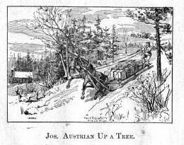
Stories about the Austrians’ sawmill and home in Bayfield are shared in Joseph Austrian’s Memoir, and in Benjamin Armstrong’s Memoir.
The town of Bayfield, Wisconsin, was platted shortly thereafter, Marks and Julius Austrian being the preemptors, and Mrs. Julius Austrian the first white woman resident at that place. The history of these enterprising and prominent families, it will thus be seen, falls properly to Wisconsin, but in addition to what has been mentioned, it should be stated that within a few years after 1850 they had established leading stores in Michigan, at Eagle River, Eagle Harbor, the Cliff Mine, Calumet, and at Hancock, Mr. Joseph Austrian having selected at the latter place the site for its first store and warehouse. The Leopolds came from Baden where their name was Freudenthaler; the Austrians, whose name originally was Oesterreicher, came from Wittelshofen, Bavaria. As is obvious, the name in each instance was changed purely for convenience.

Map of the City of Bayfield, La Pointe Co., Wisconsin : Showing the Situation of Lands of Lyman C. Dayton of St. Paul, Minnesota, in and Adjoining the Same, drawn by Wellman and Johnson, surveyors, circa 1856. ~ Wisconsin Historical Society
Sketch Of Edward Kanter.2
There was a young man at Mackinac who in 1846 worked for the parties just mentioned and whose name was Edward Kanter. He had come to Detroit in the fall of 1844 and remained a citizen of Michigan until his death, 52 years later. Always a modest man, he never, in spite of his prominence as a citizen, permitted the publication of his biography and the interesting facts of his career certainly deserve such preservation as the records of this Society afford. They are here set forth for the first time.
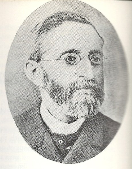
Edward Kanter “Photo published in Katz, Irving I. The Jewish Soldier from Michigan in the Civil War. Detroit, Mich.: Wayne State University Press, 1962. Page 8. Kanter served as vice-president of a Detroit soldier recruitment organization and was the first Jewish member of the Michigan Legislature. Added by: Hebrew Heritage Foundation”
~ Findagrave.com

Edward Kanter was related to German Parliamentarian Eduard Lasker (originally Jizchak Lasker).
~ Wikipedia.org
Edward Kanter was born in Breslau in 1824. His father was Louis Kanter, a prosperous linen merchant and a member of the Linen Merchants’ Guild. His mother was Helena Lasker, a near kinswoman of Edward Lasker, the German Parliamentarian, of whose birthplace she was also a native. Young Kanter graduated from the Breslau Gymnasium, equipped among other things with a knowledge of Greek, Latin, German, English, French, and Hebrew. In later years he was often heard to remark that it was his education above all things which helped him out in emergencies. A wild spirit of adventure seized him early in life with the result that he ran away from home and made his way to Paris where his knowledge of the language obtained him employment in a lawyer’s office. Six months later saw him at Havre where, as he was strolling about the wharves, a sudden impulse prompted him to go aboard a vessel bound for New Orleans. He hid behind a coil of rope until well out at sea when he was discovered and at once given a further taste of the rope accompanied by an assortment of curses in several languages. As he was able to turn away wrath with soft answers in all of the respective tongues, it instantly dawned upon the mate at the other end of the rope that he had found a much-needed interpreter for the immigrants of various nations with whom the ship was crowded. The rest of the trip was pleasant sailing for the young stowaway.
The Occident and American Jewish Advocate, Vol. IX. No. 8: Elul 5611, September 1851
——-
“Isaac Hart, Esq., of New Orleans.—We lately intimated that Mr. Hart would be presented with a token of regard from the congregation over which he had been president for several years. The presentation took place on Sunday, the 21st of September, and the following extract from the New Orleans Bee will give our readers all the particulars which have reached us:
Presentation of a Silver Pitcher.— On Sunday last, we were witness of a highly-interesting ceremony. Everybody knows Mr. Isaac Hart, of Canip Street, and most persons are aware that he is an active, zealous, and intelligent member of the German Hebrew Congregation of this city. To his unwearied exertions, his liberality, and his unflagging energy, that Congregation is indebted, in a great degree, for its present prosperity, and for the possession of a spacious and beautiful Temple for the worship of the GOD of Israel. Mr. HART retained the honorable post of President of the Congregation, devoting himself to its welfare, until its leading objects were secured. He then resigned his office, leaving to his successors a noble example of the successful fruits of diligence, religious faith, and indefatigable perseverance.
The members of the congregation, desirous of testifying their grateful appreciation of the efforts of their ex-president, subscribed toward the construction of a massive silver pitcher of exquisite workmanship, having on one side an appropriate inscription, and on the other a beautiful representation of the German Synagogue, and enriched all over with tasteful devices. On Sunday, the officers of the Congregation assembled at Mr. Hart’s residence, and Mr. George G. Levi, on behalf of that body, tendered the pitcher to that gentleman, accompanying the gift with some feeling and eloquent remarks, in which he set forth the valuable services of Mr. Hart, and the high sense of his merits entertained by the association of which he had been selected the interpreter. The donee, in accepting the splendid token, responded warmly and sincerely. He sketched the history and progress of the Congregation, from the days when, obscure and almost nameless, it first struggled into existence, up to the present time, when its members assemble weekly in a noble edifice, consecrated to the Almighty, to solemnize their Sabbath and offer up devotion and prayer to the Most High. He claimed little merit for himself, but said, that like a general in battle, he only led his soldiers, while they had won the victory by their courage and resolution. At the conclusion of the ceremony, the gentlemen and ladies present were conducted by Mr. Hart into another room, where they were entertained with cordial and profuse hospitality.”
On arriving at New Orleans, he found himself with but a single shilling which he gave to be changed to one of the sailors on the ship. The sailor did not return and so the lad landed on the soil of America with literally not a single penny in his pocket. Hardly ashore, he was laid low with yellow fever. He was taken care of by a relief committee of Jewish citizens of New Orleans, among them Mr. Isaac Hart, afterwards a resident of Detroit, a gentleman most kindly remembered by Detroiters. Upon his recovery, the same committee set him to peddling cigars until a congenial place was found for him in a drug store. The place was too congenial; he was much given to chemical experiments, reminiscences perhaps of the Breslau Gymnasium. Presently one of the experiments resulted in a bad explosion of the drug store, from the wreck of which the young scientist rushed terrified to the levee. He went aboard the first boat which happened to need a waiter. Because of his excellent penmanship he was soon promoted to the position of clerk and as such he continued to sail up and down the Red River until one day the boat happened to blow up opposite Helena. He swam ashore, worked his way to St. Louis, took a steamer to Pekin, Illinois, and walked thence to Chicago, where he shipped on the steamer Wisconsin until the close of navigation, 1844. He was now only twenty years of age, but had certainly obtained a few lessons in the larger university of life.
Jewish Virtual Library: Detroit
——-
“German Jews arrived in Detroit in significant numbers in the 1840s. Charles E. Bresler, a settler of the Ann Arbor-Ypsilanti area in the 1830s, moved to Detroit in 1844. He dealt in horses, furs, and wool, and made a fortune importing steel pens. He was one of the incorporators of Detroit’s first Jewish congregation, Temple Beth El. Edward Kanter arrived in Detroit that same year, moving to Mackinac the following year where he was employed by the American Fur Company. Later he worked for the Leopold Brothers, pioneers on the island of Mackinac in the fishery business, and fur traders. Kanter returned to Detroit in 1852 and became Detroit’s first Jewish banker and the first Michigan Jew to serve in the state legislature. Kanter Street is named after him.”
He spent the winter of 1844 in Detroit. The English he had learned at Breslau had always given him trouble, or more properly speaking, had always given trouble to those to whom he spoke, and so he profited by his stay in Detroit to take some lessons from Chas. E. Bresler, a Jewish resident of Michigan, originally from the same part of Europe as Kanter. The ensuing spring saw him again on the lakes, this time as clerk of the steamer Illinois. He left this position, however, taking employment the same year at Mackinac as clerk and interpreter for the American Fur Company, the successor to John Jacob Aster’s venture. Here again his French and English stood him in good stead. His remarkable faculty for languages revealed itself in the rapidity with which he picked up the Indian tongues. In a short time he had mastered the Huron, Chippewa, and Pottawatomie languages and even in later life could on occasion unconcernedly carry on a fluent conversation in any of them. He visited at this time Duluth and the Apostle Islands and was a passenger on the first trip of the “Julia Palmer,” the second boat to be carried on rollers around the Falls at Sault Ste. Marie.
In 1846, as has been stated, he worked for the Leopolds and Austrians. The following year he had been placed in charge of a stock of goods at the island by some eastern parties who suddenly decamped without notice to their creditors. When the latter arrived, they were so impressed by the honesty and zeal wherewith young Kanter had guarded their interests that they voluntarily turned the entire stock and store over to him on easy terms of payment, and so in July, 1847, he opened his books with a cash capital of $200. On these prospects he married a month later the daughter of former State Senator Lyman Granger of the neighboring Bois Blanc Island. He remained at Mackinac until 1852. In that year the late Mr. E. S. Heineman,3 father of the writer, recently arrived at Detroit, was sent to Mackinac to be present at the Indian payment. Mr. Kanter and he immediately became warm friends. The Indians had given Mr. Kanter, because of his bustling activity, the name of “Bosh-bish-gay-bish-gon-sen,” meaning “Fire Cracker,” and Mr. Heineman being somewhat shorter in stature than Mr. Kanter, but of equal activity, was immediately dubbed “Little Firecracker.”

Edward Kanter’s father-in-law was Senator Lyman Granger.
~ Findagrave.com
The red men always had a great liking for Mr. Kanter; they never missed an opportunity to call on him in Detroit or to send greetings to him. The merchants of Detroit in the early 60’s were at a loss one day to account for a circle of Indians gravely squatted in front of Mr. Kanter’s store on the chief business street, Mr. Kanter making one of the circle, the whole company smoking and maintaining a dense silence, until they were informed that a delegation of chiefs on their way to see the Great Father at Washington would not pass through Detroit without smoking a pipe of peace with “Firecracker.”
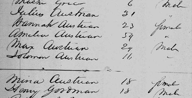
Julius Austrian also went to Germany during 1853 to liquidate his recently deceased father’s estate, and to bring the rest of his family back to settle upon the Great Lakes. Did Edward Kanter travel with the Austrian family?

German-American Bank, possibly Detroit, circa 1900-1920.
~ Library of Congress
In 1853 Mr. Kanter visited his parents in Europe. On his return he continued his successful business career. He became the founder of the German-American Bank, of which one of his sons continues at present to be a principal officer. He entered actively into political life at about this time. He was elected to the legislature of 1857, and though not a member of the prevailing party, presented and so persistently drove home a minority report on certain wrongdoings in the State treasury that the matter ended with the guilty party’s being sent to prison. He was twice made a candidate for the office of State Treasurer, but being a Democrat, the nomination was against hopeless odds. Mr. Kanter was long and conspicuously connected with the Democratic party organization. In the sixties he was Secretary of the Democratic State Central Committee; he was a delegate to the National Convention that nominated Tilden, for eight years was the member from Michigan of the Democratic National Committee. He was Commissioner from Michigan to the New Orleans Exposition, a member of the Board of the House of Correction of Detroit, and in general a constant and valuable participator in public affairs. He was Vice-President and Treasurer of Congregation Beth El in Detroit in 1855 and an unfailing contributor towards its needs. He died in June, 1896. Respected by all who knew him, he left a name synonymous with strict integrity.

“German American Bank, Detroit. Organized February 3, 1883.”
~ Annual Report of the Commissioner of the Banking Dept
By Michigan. Banking Dept, 1891, page 56.
Detail from Congregation Beth El
by Temple Beth El (Detroit, Mich.), 1900, page 54.
1 Data obtained through the kindness of our fellow-member, Rev. Dr. Jos. Stolz, from Mrs. Julius Austrian (Hannah Leopold), and other members of the Austrian family.
2 Data supplied mainly by Hon. Henry L. Kanter of Detroit, son of Edward Kanter.
3 Farmer’s History of Detroit, Vol. II, p. 1155. The friendship of these two young men, thus meeting on this distant and savage island, was a most natural one. Both had been born in the same year, both had received a superior education in Europe, and both had left homes of comfort and luxury, having been equally unfitted by temperament to endure the political and other conditions then prevailing abroad. Their friendship endured until 1896, being terminated by death, Mr. Kanter surviving his friend only a few days.
Barber Papers: “Apostle Islands” Summer of 1857
February 13, 2016
By Amorin Mello
Selected letters of the Joel Allen Barber Papers
… continued from the Spring of 1857.
This season (Summer of 1857) of the Barber Papers begins with this editorial commentary from Chequamegon History because the Barber Papers do not contain much information about events that occurred during this time period. Fortunately, letters from Giles Addison Barber preceding this season indicate that he had planned to take his second trip west from Vermont to Lake Superior in order to rejoin his son Joel Allen Barber during the Summer of 1857.
Giles’ first trip in the Spring of 1856 was tragically disrupted by the death of his first son Augustus Hamilton Barber, and was unprepared to reconcile Augustus’ unfinished copper claims, land speculations, and U.S. General Land Office survey contracts during that trip. The vocabulary Giles used to describe employees and politics at the U.S. General Land Office in Superior City were not admirable. Giles sought reconciliation by applying pressure upon national politicians in his social network (particularly Alvah Sabin; U.S. Representative from Vermont), and began preparations for this second trip.
Augustus Hamilton Barber had begun to work closely with George Riley Stuntz earlier in 1852 to survey the far northwestern region of the Wisconsin Territory; their most recent survey together before the Summer of 1857 had been at the Gardens in Odanah of the LaPointe Indian Reservation during the Fall of 1856. Stuntz’s nephew Albert Conrad Stuntz began surveying the Gogebic Iron Range of La Pointe County during the Summer of 1857. Lysander “Gray Devil” Cutler moved to Ironton during the Summer of 1857 as the new managing agent on the Gogebic Iron Range for the Wisconsin & Lake Superior Mining & Smelting Company to operate in collusion with Stuntz’s survey of the Gogebic Iron Range for the U.S. General Land Office.
“Mr. Cutler was appointed the managing agent of this prospective Wisconsin bonanza, at a fair salary, to which was added a liberal amount of the stock of the company. His first task was to perfect the title to the property, and the first step toward it was to take a personal view of the situation and the property. It was a somewhat arduous undertaking, not unfraught with danger. Excepting two or three traders and surveyors, who had stock in the company, the population, which consisted mostly of Indians and half-breeds, viewed this incursion of wealth-hunters from the lower lakes with suspicion and distrust. To add to the difficulties of the situation, other parties owning Sioux script were endeavoring to acquire a title to the mineral range. One man working in the interest of the company the year before, had been discovered, after being missed for some weeks, dead in the forest, near the range. Bruises and other indications of violence on the body gave strong ground for the belief that he had been murdered. Altogether it was a position, the applications for which were not numerous. His [Cutler’s] first trip was made in the Summer of 1857.”
~ History of Milwaukee, Wisconsin:
From Prehistoric Times to the Present Date
Milwaukee Genealogical Society, 1881, page 790.

“IN MEMORY OF
AUGUSTUS H. BARBER
of Cambridge, Vt. U.S. Deputy Surveyor
who was drowned in
Montreal River
Apr. 22. A.D. 1856
Aged 24 yrs. & 8 ms.”
~ FindAGrave.com
The death of this unnamed managing agent that Cutler replaced corresponds with the timing of Augustus’ death in the Spring of 1856. Augustus’ last letters reveal that he had gotten into “A Little Trouble“ and decided to “Let ‘Em Rip“ shortly before his death. Augustus was reported to have drowned below Superior Falls near Ironton and the Mouth of the Montreal River. However, a confidential letter written by Giles to Allen on the first year anniversary of Augustus’ death reveals that the location actually occurred further inland under secret circumstances:
“It must remain a sealed book to us, how Augustus was hurried out of the woods, and why it was so ordained if there, was any ordination about it, till we meet him in another world, which I devoutly hope we may do though I am sorry to say more hoping than expecting.”
Augustus is suspected to have been the unnamed managing agent found dead near the Gogebic Iron Range that Cutler replaced. There was a footpath between the Gogebic Iron Range and Ironton, which supports this speculation. James Smith Buck was an elected official of La Pointe County during the Summer of 1857, and wrote memoirs about working in the Penokee Survey Incidents with Cutler and Stuntz. Buck’s memoirs glorified another traumatic event at Ironton which involved Cutler and his management approach to disciplining the mining company’s Lake Superior Chippewa employees at these locations. Buck did not make any references to the Barbers in his memoirs; however, Asaph Whittlesey published a public retort to Buck’s memoirs with a cryptic allusion to “the Siege of Barlisle“. Whittlesey’s reference is suspected to have been about the murder of Augustus Hamilton Barber.
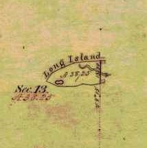
Detail of Chequamegon Point included in the Barber brother’s survey of T47N R4W during the Summer of 1855.
Without further speculation about how the Barber family may have been involved with the 1857 Stuntz/Cutler survey of the Gogebic Iron Range, the rest of this will be dedicated to the 1857 Barber survey of we can focus on the Barber brothers’ survey of what is now the Apostle Islands National Lakeshore.
Joel Allen Barber and his brother Augustus Hamilton Barber began their work to survey the Apostle Islands at Chequamegon Point on Long Island during the Summer of 1855. Augustus and Allen continued their survey of the Apostle Islands during the Winter of 1856:
“We shall go back in a few days and commence surveying around the islands. Now don’t fancy that we cannot survey in the winter, for we have tried it and know better.”
After Augustus’ death, Allen rewrote their original field notes of the Apostle Islands survey during the Winter of 1857, per instructions from their father:
“Keep a strict acct of all the expense of resurveying on the last winters contract, if you get a new one & undertake it, as I am informed that I can get relief from Congress by a special act, paying me all that it will cost to do the work over again, which will be as much for you interest as anybody’s of this please say nothing to any one.”
Allen then renewed their contract for this survey during the Spring of 1857, causing much anxiety for their father despite giving instructions to do this:
“I am surprised to learn that you are going to survey islands so late in the season. Nothing that I can now say will avail any thing else I would caution against trusting too long to the treacherous covering over the dark blue waters. I hope you will have good success and get through without any fatal accidents to your self or to any one of your party.”
The Barbers’ survey field notes were finally accepted as complete by the U.S. General Land Office during this season; the Summer of 1857.
“… the survey of the Apostle Islands, in Lake Superior. The survey of those islands was executed by J. Allen Barber, deputy surveyor, with unusual care and trouble.”
~ Message of the President of the Untied States to the Two Houses of Congress at the Commencement of the Second Session of the Thirty-Fifth Congress, 1858, page 119.
The following documents are the original surveys notes of the Apostle Islands as submitted by Deputy Surveyor Joel Allen Barber during the Summer of 1857. Augustus Hamilton Barber’s former role in these surveys during 1855 and 1856 was not mentioned anywhere in his brother’s survey notes. In lieu, Joel Allen Barber identified three assistants during these surveys:
- William W Ward
- Alexander Aiken
- Louis Nevioux
Aiken and Neveau are familiar surnames in Lake Superior Chippewa communities.
Our transcriptions of selected letters from the Joel Allen Barber Papers are continued below without further editorial commentary:
Exterior Field Notes
Township 51 North, Range 2 West
Township 52 North, Range 1 West
Township 52 North, Range 2 West
Township 53 North, Range 1 East
Township 53 North, Range 1 West
Township 53 North, Range 2 West
April 1857
Notebook ID: EXT27501
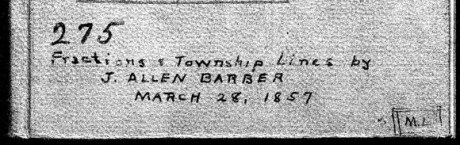
Joel Allen Barber received this survey contract on March 28th, 1857, from Warner Lewis at the General Land Office in Dubuque, Iowa.
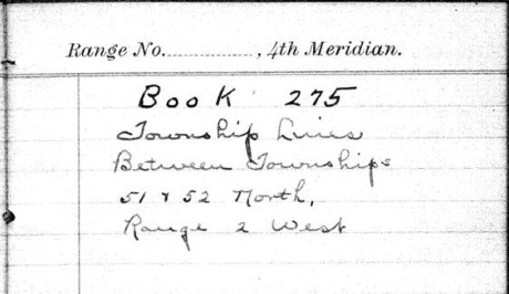
“Township Lines Between Townships 51 & 52 North, Range 2 West”
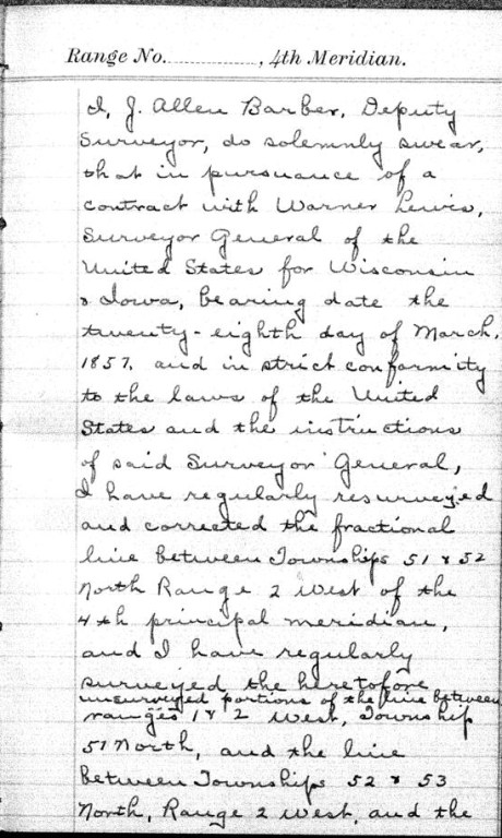
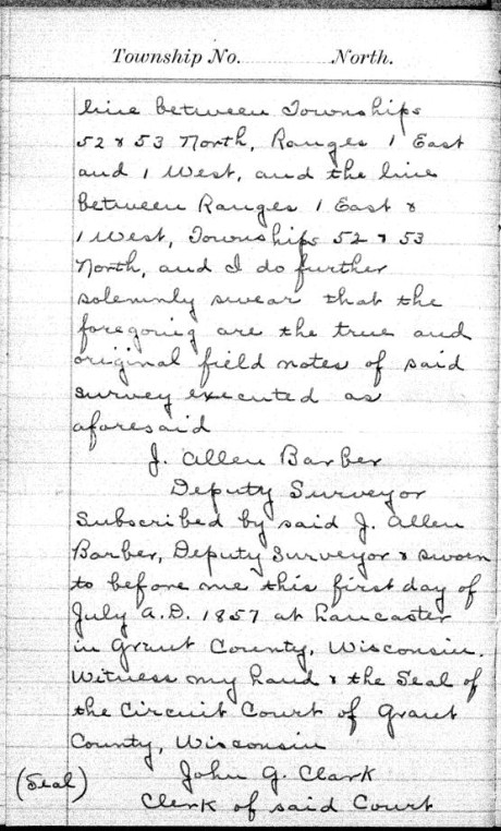
These survey notes were originally sealed in Lancaster, Grant County, on July 1st, 1857.


Interior Field Notes
Barber, J. Allen
Mar. 1857
Notebook ID: INT011E03

“No. 11 T. 46-47-52-&53. R. 1. East”
Township 46 North, Range 1 East
[Joel Allen Barber’s survey notes for this township are referenced by the the Wisconsin Public Land Survey Records, but is are omitted from the General Land Office Records. A survey map published by Charles Whittlesey in 1860 reveals diverse geology, one mineral claim, and part of the ancient Flambeau Trail were documented in this township.]

Detail of T46N-R1E and the surrounding region from Charles Whittlesey’s Geological Map of the Penokie Range, 1860.
Township 47 North, Range 1 East
[One more minor Chequamegon History editorial commentary: Joel Allen Barber’s survey notes of this township are referenced by the Wisconsin Public Land Survey Records, but are omitted from the General Land Office Records. This township is featured in the above detail of Whittlesey’s 1860 map. It is near Ironton; and contains the Mouth of the Montreal River, Superior Falls, and Saxon Falls.]

Superior Falls at the mouth of the Montreal River, as featured in the stereograph “View on Montreal River” by Whitney & Zimmerman from St. Paul, circa 1870.
~ Wikimedia Commons
Township 52 North, Range 1 East
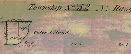
Barber’s survey of T52N R1E included the southeast corner of Outer Island, the rest of this township is occupied by Lake Superior. There are no survey notes available for this township, it was included in the survey of T53N R1E for convenience.
Township 53 North, Range 1 East

Barber’s survey of T53N R1E features the east half of Outer Island, the rest of this township is occupied by Lake Superior.
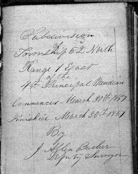
“Commenced March 30th, 1857. Finished March 30th, 1857.”

Barber’s assistants were William W. Ward, Alexander Aiken, and Louis Nevioux.

These survey notes were sealed in Lancaster, Grant County, on July 1st, 1857. Barber’s assistants were not signatories.
Interior Field Notes
Township 51 North, Range 1 West
Barber, J. Allen
Apr. 1857
Notebook ID: INT010W04

Barber’s survey of T51N R1W included Michigan Island, Gull Island, and a corner of “Presque Island” (Stockton Island).
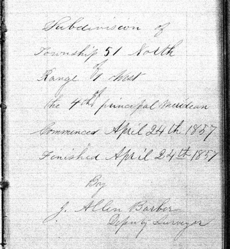
“Commenced April 24th, 1857, and finished on April 28th, 1857.”

Barber’s assistants were William W. Ward, Alexander Aiken, and Louis Nevioux.
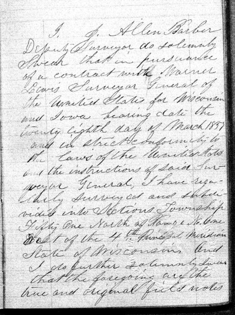

These survey notes were sealed in Lancaster, Grant County, on July 1st, 1857. Barber’s assistants were not signatories.
Interior Field Notes
Township 52 North Range 1 West
Barber, J. Allen
Apr. 1857
Notebook ID: INT010W05
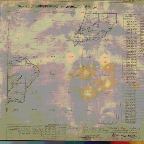
Barber’s survey of T52N R1W included the northeastern end of “Presque Island” (Stockton Island) and the south western end of Outer Island.

“Commenced March 28th, 1857. Finished March 31st, 1857.”

Barber’s assistants were William W Ward, Alexander Aiken, and Louis Nevioux.
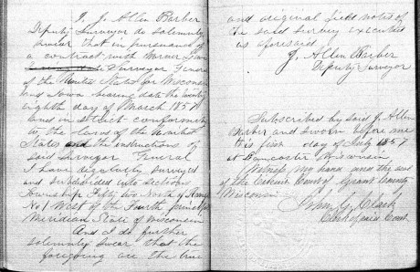
These survey notes were sealed in Lancaster, Grant County, on July 1st, 1857. Barber’s assistants were not signatories.
Interior Field Notes
Township 53 North Range 1 West
Barber, J. Allen
Apr. 1857
Notebook ID: INT010W06

Barber’s survey of T53N R1W included the northwestern part of Outer Island. The rest of this township is covered by Lake Superior.

“Commenced March 29th, 1857. Finished March 30th, 1857.”

Barber’s assistants were William W Ward, Alexander Aiken, and Louis Nevioux.
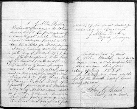
These survey notes were sealed in Lancaster, Grant County, on July 1st, 1857. Barber’s assistants were not signatories.
Interior Field Notes
Township 50 North Range 2 West
Barber, J. Allen
Apr. 1857
Notebook ID: INT019W04

Barber’s survey of T51 R2W included part of Madeline Island.

“Commenced April 22nd, 1857. Finished April 23rd, 1857.”
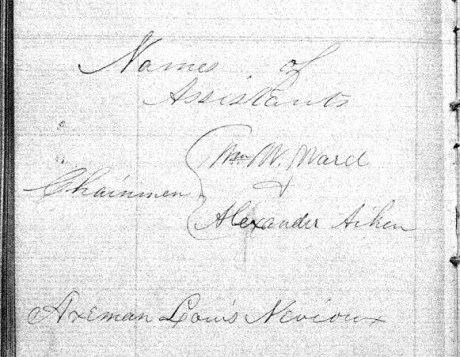
Barber’s assistants were William W Ward, Alexander Aiken, and Louis Nevioux.
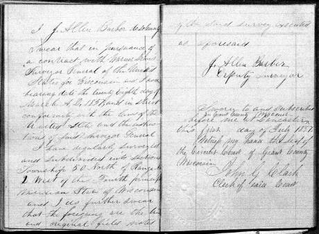
These survey notes were sealed in Lancaster, Grant County, on July 1st, 1857. Barber’s assistants were not signatories.
Interior Field Notes
Township 51 North Range 2 West
Barber, J. Allen
Apr. 1857
Notebook ID: INT019W02

Barber’s survey of T51N R2W included the LaPointe Indian Reservation Fishing Grounds on the north end of Madeline Island, and parts of “Wilson’s Island” (Hermit Island) and “Presque Island” (Stockton Island).

“Commenced April 17th, 1857, and finished April 23rd, 1857.”

Barber’s assistants were William W Ward, Alexander Aiken, and Louis Nevioux.
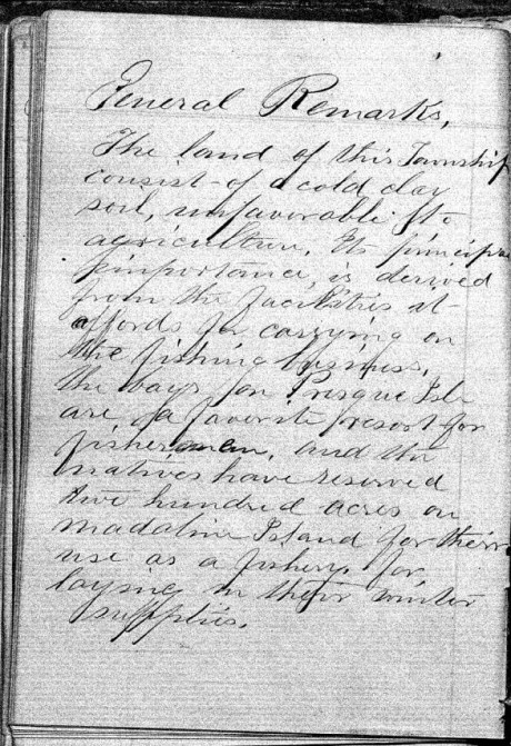
“The land of this Township consists of a cold clay soil, unfavorable to agriculture. It’s principle importance is derived from the facilities it afford for carrying on the fishing business, the bays for Presque Isle are a favorite resort for fishermen, and the natives have reserved two hundred acres on Madeline Island for their use as a fishery, for laying in their winter supplies.”


These survey notes were sealed in Bayfield on May 30th, 1857, by Samuel Stuart Vaughn as Justice of the Peace for LaPointe County. Alexander Aiken was not a signatory, yet William W Ward and Louis Nevioux (“his X mark”) were included as signatories. This nuance was not explained.

There appears to be something written or drawn behind the smaller sheet in this scan of Barber’s original survey field notes.
Interior Field Notes
Township 52 North Range 2 West
Barber, J. Allen
Apr. 1857
Notebook ID: INT019W03
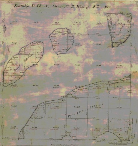
Barber’s survey of T52N R2W included “Devil’s Island” (Manitou Island), an unnamed island (Ironwood Island), and parts of “Hemlock Island” (Cat Island), and “Preque Island” (Stockton Island).
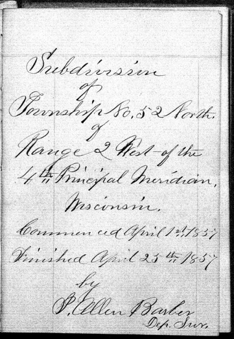
“Commenced April 1st, 1857. Finished April 25th, 1857.”

“There is but little good land in this Township, the greater part being of a very inferior quality, there is some good White Pine on Presque & Hemlock Islands.”
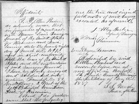
These survey notes were sealed in Bayfield on May 30th, 1857, by Samuel Stuart Vaughn as Justice of the Peace for LaPointe County. Alexander Aiken was not a signatory, yet William W Ward and Louis Nevioux (“his X mark”) were signatories. This nuance was not explained.
Interior Field Notes
Township 53 North Range 2 West
Barber, J. Allen
Apr. 1857
Notebook ID: INT019W05
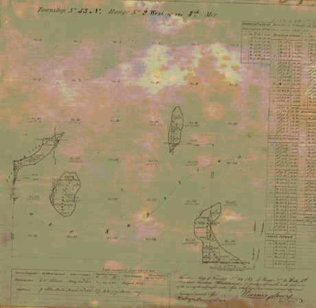
Barber’s survey of T53N R2W included “Shoal Island” (South Twin Island), an unnamed island (North Twin Island), the north end of “Hemlock Island” (Cat Island), and the east end of “Ironwood Island” (Rocky Island).

Barber’s assistants were William W Ward, Alexander Aiken, and Louis Nevioux.
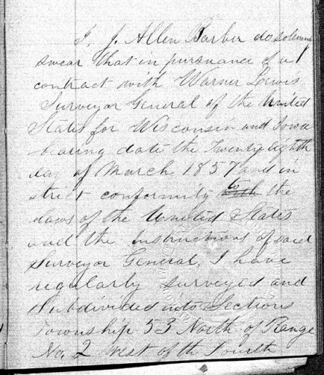
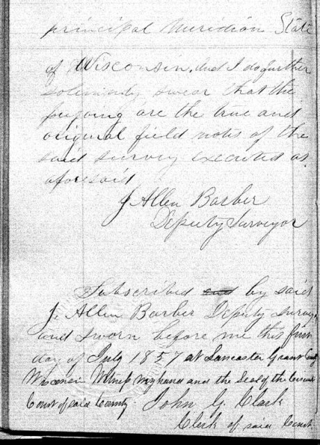
These survey notes were sealed in Lancaster, Grant County on July 1st, 1857. Barber’s assistants were not signatories.
Interior Field Notes
Township 51 North Range 3 West
Barber, J. Allen
Apr. 1857
Notebook ID: INT030W06

Barber’s survey of T51N R3W included parts of “Bass Island” (Basswood Island), “Wilson’s Island” (Hermit Island), Oak Island, and the mainland where the Red Cliff Band of Lake Superior Chippewa was located six years later in 1863.

“Commenced April 14th, 1857. Finished April 28th, 1857.”

Barber’s assistants were William W Ward and Alexander Aiken, and Louis Nevieux.

“The land in this Township is all high and rolling and is pretty well adapted to agricultural pursuits, the soil is gravelly and in some places stony. The poorest portions are Wilson’s and Bass Islands, which contain more clay. Much good White Pine & Hemlock are found on the Main shore near the Lake.”

These survey notes were sealed by Samuel Stuart Vaughn at Bayfield on May 30th, 1857, by Samuel Stuart Vaughn as Justice of the Peace for LaPointe County. Alexander Aiken was not signatories.
Interior Field Notes
Township 52 North Range 3 West
Barber, J. Allen
Apr. 1857
Notebook ID: INT030W07
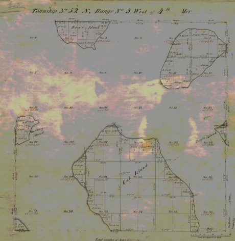
Barber’s survey of T52N R3W included parts of Oak Island, “Devil’s Island” (Manitou Island), Bear Island, “Cranberry Island” (Raspberry Island), an unnamed island (Otter Island), and the mainland where the Red Cliff Band of Lake Superior Chippewa were located six years later in 1863.

“Commenced April 4th, 1857. Finished April 29th, 1857.”
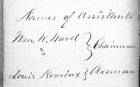
Barber’s assistants were William W Ward, and Louis Nevioux. Alexander Aiken is not identified as an assistant in this survey.

“The principal part of the land of this Township is of good quality. Oak & Bear Islands are very high and rolling with a good soil. The Island in the N.E. part of the Township is more level, but it soil is of a good quality.”
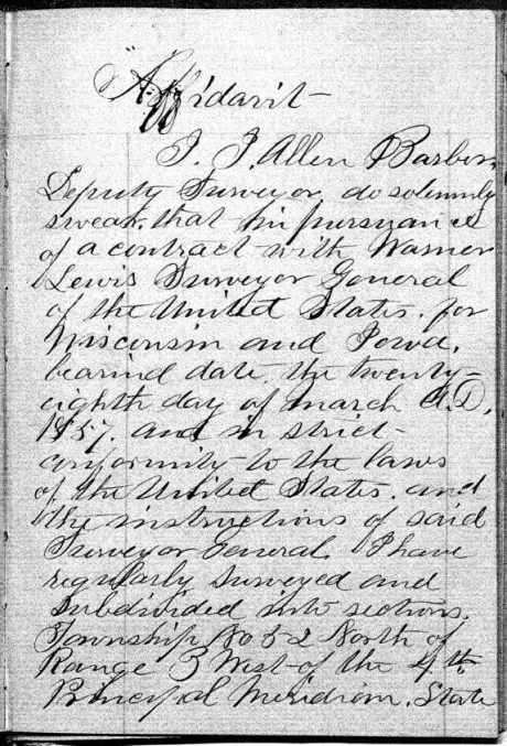

These survey notes were sealed by Samuel Stuart Vaughn in Bayfield on May 30th, 1857, as Justice of Peace for LaPointe County.
Interior Field Notes
Township 53 North Range 3 West
Barber, J. Allen
Apr. 1857
Notebook ID: INT030W08

Barber’s survey of T53N R3W included an unnamed island (Devils Island), the west end of “Ironwood Island” (Rocky Island), and the north end of Bear Island.

“Commenced Apr 4th, 1857. Finished Apr. 7th, 1857.”
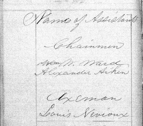
Barber’s assistants were William W Ward, Alexander Aiken, and Louis Nevioux.
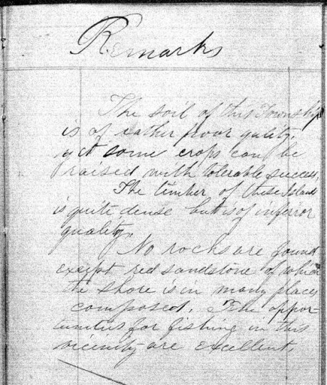
“The soil of this Township is of rather poor quality, yet some crops can be raised with tolerable success. The timber of these Islands is quite dense but is of inferior quality. No rocks are found except red sandstone of which the shore is in many places composed. The opportunities for fishing in this vicinity are excellent.”

These survey notes were sealed in Lancaster, Grant County on July 1st, 1857. Barber’s assistants were not signatories.
Interior Field Notes
Township 51 North Range 4 West
Barber, J. Allen
Apr. 1857
Notebook ID: INT040W04

Barber’s survey of T51N R4W on the mainland was used to locate the Red Cliff Reservation years later in 1863

“Commenced April 30th, 1857. Finished May 8th, 1857.”

Barber’s assistants were William W Ward, Alexander Aiken, and Loius Nevioux.
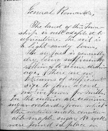
“The land of this Township is well adapted to agriculture. The soil is a light-sandy loam. The surface is generally dry, being sufficiently rolling to secure drainage. There are no streams of sufficient size to power a good motive power for mills. In the interior are extensive sugar orchards, from which the natives make considerable maple sugar. No wells were found in place in …”

“… this Township, but it belongs to the sand-stone formation and is overlaid by drift,- in some places to the depth of several hundred feet. No houses or other improvements were noticed.”


These survey notes were sealed in Bayfield on May 30th, 1857, by Samuel Stuart Vaughn as Justice of Peace for LaPointe County. Alexander Aiken was not a signatory, yet William W Ward and Louis Nevioux (“his X mark”) were signatories. This nuance was not explained.
Interior Field Notes
Township 52 North Range 4 West
Barber, J. Allen
Apr. 1857
Notebook ID: INT040W05

Barber’s survey of T52N R4W included Point Detour on the mainland, an unnamed island (York Island), the west end of “Cranberry Island” (Raspberry Island), and the east end of “Sand River Island” (Sand Island).

“Commenced April 8th, 1857. Finished April 12th, 1857.”
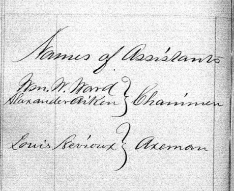
Barber’s assistants were William W Ward, Alexander Aiken, and Louis Nevioux.
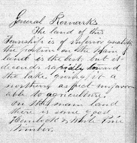
“The land of this Township is of inferior quality, the portion on the main land is the best, but it descends rapidly toward the lake, giving it a northern aspect – unfavorable to agriculture. On the main land there is some good Hemlock & White Pine timber.”


This survey contract was at Bayfield on May 30th, 1857, by Samuel Stuart Vaughn as Justice of Peace for LaPointe County. Alexander Aiken was not a signatory, yet William W Ward and Louis Nevioux (“his X mark”) were signatories. This nuance was not explained.
Interior Field Notes
Township 52 North Range 5 West
Barber, J. Allen
Apr. 1857
Notebook ID: INT050W04

Barber’s survey of T52N R5W included “Steamboat Island” (Eagle Island), “Little Steamboat Island” (no longer exists), and most of Sand Island.
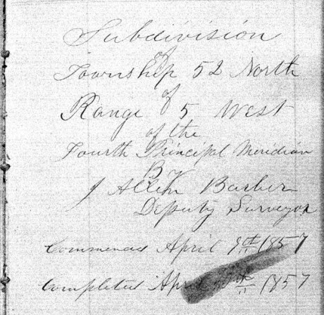
“Commenced April 8th, 1857. Finished April 10th, 1857.”

Barber’s assistants were William W Ward, Alexander Aiken, and Louis Nevioux.
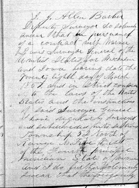
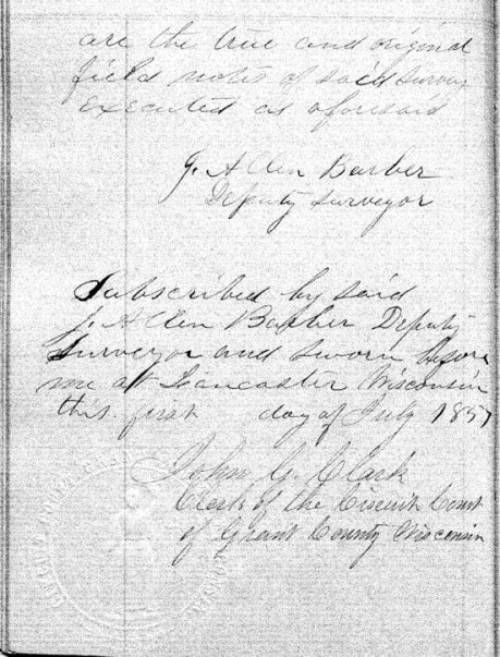
These survey notes were sealed in Lancaster, Grant County on July 1st, 1857. Barber’s assistants were not signatories.
Bayfield Mercury, August 22, 1857.
IRONTON
The Barbers did business with William Herbert and others at Ironton. The activities of “the company“ during the Summer of 1857 are detailed the Penokee Survey Incidents.
“… Wm. Herbutt, was here in 1847-48 prospecting for copper for the American Fur Company.”
Report of the City Statistician, Volume 1, page 58.
Week before last we took a trip to Ironton and the interior in company with Mr. HERBERT, the Agent of the town, and several others, and promised to give our readers an account of the the town and country back of it, but inasmuch as some kind friend took the liberty of abstracting our memorandum book from our pocket, we cannot give as definite an account as we would like.

Lake Superior surveyor, American geologist, and Harvard University professor Josiah Dwight Whitney. ~ Portrait of Whitney by Silas Selleck, 1863.
Ironton is situated on the South shore about 20 miles from this place and three fourths of a mile from the mouth of the Montreal river, which is the State line between this State and Michigan. Its harbor is good and the water is of sufficient depth for any of the largest class of steamers. The company are building a splended pier, 400 feet long, and when finished it probably will be one of the most substantial piers on the Lake, and will cost about $5000. They have also erected a large Hotel, two stories high, and we also noticed the materials on the ground for putting up several frame buildings, and arrangemnts has been made for the erection of a steam sawmill with 40 horse power, which is to be completed this summer, and will cost from $10,000 to $12,000. The lots are 40 x 125, except on 1st and 2nd streets which are 40 x 128.
The site of the town is beautiful, — about a third of it is on a nice level next to the Lake, and then it ascends gradually in benches back for one or two miles. Its near proximity to the Copper mines on the Montreal river and the Iron range back, together with the farming lands, which by the bye is not equalled on Lake Superior, must needs make Ironton a town of no small importance. The company are cutting out a good road from Ironton to the Iron range some 16 miles in length.
While there we visited the Falls on the Montreal river, the scenery of which cannot be surpassed on the Lakes. The lower falls are 60 feet high and the upper falls are 80 feet. They are about three miles apart. The indication of mineral between the two falls and especially on Mr. WHITNEY’s claim, bids as fair for large deposits of copper as any that has yet been discovered and certainly has a good surface show as had any of the mines that are now being developed.
We could say much more about the Iron range and surrounding country, but defer it until another time. The town was only laid out in February last, and it already bids fair for a bright future. Go on gentlemen, we hope you will build up a large town, and help develop the vast resources of the Great Northwest, and we will aid you what we can.
Lancaster Aug 30th 1857
Dear Son.
Maria Green Barber. She came to Lancaster to visit her in-laws, and to consider relocating there from Vermont.
A week or more since I rec’d a letter from [you?] at Bayfield by [????] I am happy a safe arrival for which I am very thankful. But in it you don’t say where your father is. [??? ???ably] return or whether he intends to come here, or go home, or other ways expecting me to go along [???? ?? ?? ????? ????] I have not had a letter from him since you left but father Barber goes on some other which road. I have not [?????] to [????????] as [????????????] about [?? ???] there to get it. Mr Burr [??????] last [??? ???] – I did not know what to do about going but as the friends here so I Pray [??? ???] he would come this way to see to his produce [????????] was out state with [???] that time I thought but to wait a little longer. [?? ??? ????] an [????] I wished I would stay with this while [?? ??? ???] as they are rather homesick [???] the [???? ??? ??? ??? ????? ??????] [????? ??? ??????] I enjoy myself better with them than of [???? other affect?] as it is such a pleasant family and very young so comfortable quilt – Last evening the Bank came up here to give me a seranade. They had intended to come [???] and were expected and They were invited in and treated to Coffee, pie, and cake and the girls gave them the best music – as they said – on the Piano they ever heard – Then they all joined in several songs They went to nearly every house in the town “to wake them up.” Yesterday Miss Barber got in another exhibition – that is, had them (her exhibit) & had something to speak – had a stage in [??????] grove where they exhibited had a pre-mer. I tried to get some – singing – pretty much failed in that – tried to get out there hard and wholely failed – and on the whole, not “[????? ???????]” they say.
It is quite [??????] here [????????? ???? ????] several others of summer complained. There has been hot months but, [???? ?????? ???? ????? ????? ?????] Esq [M????] wife are considered [????? ??? ????]
I wish I knew what [???? ? ??? ???? ????] as your father would write [??????? ??????? ????? ??? ???] to go home without [???????] at last. Got a line from [Albe?] last week. Suppose he [????] to as he does not [?????] to [???????????????????] but “lying ‘round longer.” [??? ??] very sorry he was not that [winter?] the government and instruction of some one who would have taught him something useful and kept in a study.
It is beautiful weather now for gathering the grain [????? ???? ????? ????????? ????] will be plenty of them but very little fruit of any kind this year.
I expect father will come this week without fail if he comes at all. Have heard nothing more about going to Cassville. Uncle Allen is building a large office and Cyrus and Thode are building the Evert house fence. Write often, till you come, to your
Mother
Johnson Sept 20 /57
Friend Allen
May I call you friend? I will venture for if I recollect right we were once very good friends and I hope that we are so still although we are far distant from each other, and may never meet again in this world, have you forgotten Hattie? I have not forgotten Allen and probably never shall, and were I even disposed I have a small gillon badge laid safely away which brings forcably to my mind an old friend who much resembles you, when I once knew. Amherst said he presumed you would not think I was very naughty to dare to write to you, so I thought I would take the liberty. I have written enough so I will close by saying please don’t forget the Johnson people for we shall never forget you.
Good night
Hattie C.
P.S.
Beware of those pretty squaws out there.
Allen,
I want you to understand that Miss Hattie & Miss Hastings & Carls & I have spent the evening here together at Mr. Caldwells upstairs & have had all sorts of good times. That is, as far as I am concerned. (I do not speak for the ladies) & I have enjoyed myself “excruciatingly” (as Hattie suggests) considering the company & the advantages I had.
That’s all
Am
Lancaster Sept 20th 1857
Dear Son.

Portrait of George Riley Stuntz. ~ The Eye of the North-west: First Annual Report of the Statistican of Superior, Wisconsin by Frank Abial Flower, 1890, page 26.
I will venture to write once more to you tho I have no evidence that my letters ever reach you. I have had two letters from you but not one from father since you left here. One from him to Mr Burr of Sept 15-6th appears to be the only one he has sent here since you arrival. Why he has not written to me to let me know what to do about going home I cannot understand, but here I am yet, and shall stay, until he either comes or writes he is not coming. I should have written several times to him, had I not expected him every week [??????????] letter [????] that you had not [??????] from [???????] I had not gone home with Mr B. Mr Stunts [visited?] here, and said he was going [??????] to La Pointe [???? ??????] you have learned the state of affairs before this. Mr [??] returned home last night having been about now a few weeks, had a fortunate trip tho on Lake Ontario there was a high wind and every passenger very sick. I am thankful to have escaped that, but something else may happen to us when I do go. Oh how I do dread the journeys.
I am confident that your father will be here this week, that is if he is not still too sick to come – which I greatly fear he is. If he is still there when this arrives he may [c??????] it as much to him as to you. How I wish you would confide to travel there this fall and to remain with [me?] [?????] to me the [??????????] and remain there this winter [?????????????????????????????????????????????????????]
There will be a County Fair held here this week – the grounds in full view of Uncle Jay’s where I am now stopping. I shall probably see some of the best food [ration?] of this great country. I went, two weeks since to McCartney and Cassville with Allen and family. Had a pleasant ride, but it was very warm and dusty. Mc has a beautiful place, the largest orchard in the county, I suppose, as they will have 500 bushels this fall. It is on the highest land 2 miles east of the Miss. river. But perhaps you have been there, if not you have seen the river at other points. I was wishing to see the “great river” and went to Cassville for that purpose. It is certainly worth the trouble of going to see. Aunt Sa’h pointed out to me a high sharp bluff which Augustus climbed and left his name out on the white bark of a [tree?]. To me, how interesting – almost sacred does every thing appear where he has left the impress of his work. There is nothing can bring so forcibly to our minds a dear departed friend, as a sight of the productions of his hands or his mind. So, if we would be remembered with pleasure and gratitude we must do something for the good of every being with whom we have to do.
“IN MEMORY OF
AUGUSTUS H. BARBER
of Cambridge, Vt. U.S. Deputy Surveyor
who was drowned in
Montreal River
Apr. 22. A.D. 1856
Aged 24 yrs. & 8 ms.”
~ FindAGrave.com
I hope your father has placed the marble he sent me enclosed the grave of the dear one who lies on the land here, I feared shall never have the melancholy satisfaction of visiting the cursed spot. It hardly know whether I can wish to behold the terrible scene where he lost his prime life. I cannot but fear that those of my family now in that inhospitable shore may be laid beside that line [??] bed grave that we may all live to [???? ???? ?????].
And land flowing with milk and sugar – than which no better can be found, at least I have yet found a place better adapted in all respects to make life comfortable. With labor and care we can have all that is desirable there – without those we can h should have little enjoyment here unless we are content to live in poverty and filth. One thing alone would discourage me from coming to this Western world, where in the great uncertainty or procuring a constant convenient supply of good soft water. Here, at Jay’s, their Cistern leaks and they have to fix up the pump and have to draw it from the bottom where it [????? ?? ???] with a pail and string, as they do at Allen’s and Thode’s you know there is no cistern and they manage to catch some in tubs to wash with.
It would almost kill Marth and the girls to bring enough from the spring near as it is, based on when they get it, it is good for nothing to wash with in that it is cleansed with [??? ?? ???]. I never yet saw water so convenient, plenty and good as it is at our old home.
Mr. Harris [?????] died about 3 weeks since, and Mrs. Mills is not expected to live but a few days – perhaps hours. It has been very healthy most of the [senses?] People from other places come here to spent the summer on account of the known healthfulness of the place. One gentleman from Cleveland, with consumption, and the Drs said, come – at the end of the 1 week, he had gained 12 lbs – Says he will buy property and stay here. [Sherman Page?] is here – has commenced a select school.
I have no more to [??????????????????????????]
your Mother
Aunt Lucy is unwell to day and I have [????] the [?????].
All friends well but Allen who has his old complaint.
Am sorry this ink is not black & you can read it.
To be continued in the Fall of 1857…
Barber Papers: “A Southern Confederacy” Winter of 1857
January 27, 2016
By Amorin Mello
Selected letters of the Joel Allen Barber Papers
… continued from the Fall of 1856.
Sandusky Dec 22nd 1856
My dear Son
You will see by date of this letter, that I have progressed somewhat towards home.

Portrait of U.S. Representative James Meacham from the History of the Town of Middlebury: In the Country of Addison, Vermont by Samuel Swift, 1859, after page 388. “Much to my astonishment I now find that Mr Meacham is a habitual private tippler and is often such a condition from drink as to occasion general notice and remark […] Is it not wonderful our state has had a long list of such members, Mallory, Nole, Buck, Phelps, &c.” from 1856 letter in the University of Vermont Libraries’ Center for Digital Initiative.

U.S. Representative Alvah Sabin was mentioned earlier in the Barber Papers during the Spring and Summer of 1855. ~ Eighty-Three Years a Servant, or, the Life of Rev. Alvah Sabin by Alvah Sabin Hobart, 1885
I left Lancaster in company with E. D. Lowry for Galena last Wednesday morning & on getting to Galena found that the cars had not run for 5 days on account of snow, but they got in toward morning & at 9 AM I started & only got through to Chicago next day at night, when not running we were in snow drifts. I arrived here Saturday evening & am having a very comfortable visit with your Uncle’s family. Shall leave at 7 tonight for the East & shall make all speed for Vermont. Your Uncle’s folks are looking for Jay house tomorrow night to spend the holiday & then return again. There is something in the Tribune of last week concerning the termination of the Eastern RailRoad on the Northern boundary & laying it down as pretty certain that the road would be carried to the Mouth of Montreal River. If I can find the paper before mailing this, I will send you the article, & did I know that the road would be run to your town I would take all possible means to apprise you of the fact so that you might not dispose of your interest in the great haste. If you have sold none, when this reaches you, I trust you will act in reference to the above information, and I would advise you to keep dark, till further advice, & as fast as I can learn anything relative to your interests I will communicate the same to you. I have heard nothing from you yet, since parting with you at La Pointe, but hope to get letters from you when I get home. I have left money with Cyrus to pay your taxes, & will have him pay on Jo’s. Tell Mr. Wheeler, that I have learned the trouble concerning Hon Jas. Meacham that he & I talked about at his house. He had become a confirmed & miserable drunkard & drank himself out of the world. This is from one of his colleagues Hon A. Sabin, and is but too true.
Reverend Leonard Wheeler & Government Carpenter John Stoddard lived at the Gardens.
Give my last respects to Mr. Wheeler & family also to Mr. & Mrs. Stoddard & tell them that I have not escaped a hard winter as [?????? ?????? ??????] but do not fear starvation like I did on L. Superior.
I expect you are all buried in deep snows by this time, so that you can do nothing at Surveying. The Snow was 2 ft deep at Lancaster when I left, but it rained all day Friday like July Showers & the ground is entirely bare about this place. Her Bay is frozen over. Keep a strict acct of all the expense of resurveying on the last winters contract, if you get a new one & undertake it, as I am informed that I can get relief from Congress by a special act, paying me all that it will cost to do the work over again, which will be as much for you interest as anybody’s of this please say nothing to any one.
Now My dear Son I again implore you to be careful of your life & health. Do provide yourself with enough to make yourself comfortable & easy & above all good warm clothing & bedding, be careful of exposing yourself, where you there is danger of being lost & freezing, or of getting through the ice. Do my son heed the requests of your parents & only brother who feel more interest for you than you are aware of, & who are in hopes to yet enjoy your society in a more genial soil & climate.
I think that one visit to Lancaster will be sufficient to wean you from the frozen, famine stricken, regions around the Great Lake. I overhauled my agates yesterday giving lots of them to the children, also specimens &c. I gave them some chrorastrolites & shall give them some more. They prize them very high. The stone that Jo gave Lucy & she to your Uncle, has been cut & set in two rings. 1 for Aunt Em & 1 for Lina… Aunt E’s ring cost $12.00 besides the stone. It is a splendid affair.
Do write as often as you can, for be assured that your letters will be always joyfully rec’d & read by your parents & Hiram.
Farewell my dear Son & may God preserve your life & health
G. A. Barber
Respect to the boys.
Cambridge Dec 29th 1856
My dear Son
It is now about 2 months since I left you at La Pointe, since which time I have not heard one word from you, whether you were in the land of the living, or had got cast away on your journey to Montreal River. I was very anxious to get intelligence from you while at Lancaster & could not feel reconciled to come away till I had heard from you. But having left directions with our friends there to forward your letters, if any came, to me. I finally ventured to start for Vermont. I stopped over 48 hours at Sandusky, & wrote you from there, on matters pertaining to Ironton, which will reach you long before this does. If you have not sold any shares, it would be best to rest easy till you see how the matter turns, but if the road is likely to terminate at the Mouth of Montreal River, some shark will be after all the shares he can get, & at the lowest prices. I left Sandusky Monday night (22nd) at 7, was in Buffalo at 7 next morning & Albany at 10 P.M. Rutland at [morn?] Wednesday. Called on Mrs. Temple & Nancy Green, got to Burlington at 8 P.M. on the 24th & home on Christmas at sunset, found all well and tired out with looking for me. Every thing looks as natural as ever, except that our Prairies are more rolling & the bottoms greatly shrunken in dimensions.
[…]
Mr. Whiting had a partner, B. E. Fullington, an honest, God-fearing, upright man, and their plan was to engage in farming–raising corn for the Government post at Fort Riley. Mr. Fullington soon became disgusted with the meager success that attended their efforts, and after one season returned East, leaving Mr. Whiting to conduct the business. Mr. Fullington agreed to furnish the capital while Mr. Whiting was to manage the business connected with the partnership. But Kansas looked better to Mr. Fullington after he got to Vermont and he came back the next spring to spend a long and useful life here.”
~ A Standard History of Kansas and Kansans by William E. Connelley, 1918, transcribed by Baxter Springs Middle School students, 1997.
While on the platform at Essex Junction, who should I run into again? but Mr. Bradly & Fullington direct from Kansas when he left Albe! Left him well, on the land they had claimed, another man a neighbor had gone into the shanty with Albe to [book/back?] it together this winter, & take care of their cattle
Matters are more quiet there now. Gov. Geary proves a better man than was anticipated. Prospects for Terr. Kansas are brightening. I sent you the message of the infamous Frank Pierce, from Lancaster, & hope your patience permitted you to read it through. Still it is the meanest vilest paper that ever emanated from our Government and will go down to posterity with its author excerated by all good & honest persons. Folks are well around. Levi & Oscar were here last night till after 9. Of course I gave them some specimens of copper, agates &c. Mary Buck from Galesburgh Ill. sister to Mrs. Kingsbury keeps the school, from 6 to 10 scholars, & enough for such a “marm.” Ed. Bryant teaches the best school at the Center. Pat Coldwell is in a Store at Waterbury. Dr. C.L. Fisher is teaching in Johnson. Helen Whiting is about going to “Kaintucky” to teach in a family. I do not mean of her own, but in a private school.
~ Collections of the Kansas State Historical Society, Volume 12, by Kansas State Historical Society, page 119.
I am going to Johnson to day & must be brief but will perhaps do better another time. If mails are regular you will get as many as one letter per week, while I have ability to scribble for I have learned by experience how good it seems to have letters from “friends & sacred home.” Again I caution you to take care of yourself, you can read my back letters for particulars. Your mother will write soon now when she knows where you are, & I will make Amherst do likewise.
Your affectionate father
G. A. Barber
[ca. 1856]
My Dear Son.
I hardly know whether to write again to you before hearing or knowing something of your situation.
It seems too much like writing to the dear departed. But I know that if it were possible you would have sent us news of your self before now. I feel assured that it is not your fault that we do not get letters.
I often imagine you shut in from the world by deep snows – perhaps you and your party frozen – disabled from work or even from the use of the pen. But the thought of the good Christian Missionary near you makes me hope that you would not be allowed to perish with cold or hunger and that, should any great misfortune happens to you he would inform us of it. How very long and tedious must the winter have been to you all and how often the vainly have I wished you had complied with our wishes and returned to spend the winter at home. Oh! How much more pleasure and comfort might we all have then.
I mentioned in a former letter my wish to go to Lan. next summer and my great desire to meet you there. I do not know that I will take the trouble and incur the expense of such a journey if I must come back without seeing you, so do not let me be disappointed. If you will If I felt sure that you would meet me there and would return with us to spend next winter I should feel that I had something to live for. But the thought of going there and returning to live in this old, desolate, neglected, forsaken looking place without you, with no prospect if there ever being any improvement in its appearance under the present administration makes me quite indifferent to life. I am very sorry that we cannot get another woman here – one who would be agreeable and friendly with me, or whom I could confide in as a good and honest dairy woman. I should then feel quite satisfied to leave the business with her, and less unwilling to return again. But your father will not let any one else come – tho he has had some very good offers.
How I do wish that you would come and live with me and befriend me & I really need to have one friend.
Good night
Mother
Cambridge Jan 6th 1857
Dear Son
I have determined to wait in hopes to hear from you, before writing back again. It really seems strange, that we do not get something from you in all this long time, your last being dated Nov-. Your Mother & I wrote repeatedly while at Sandusky & I hope you get the letters, but why do I not get something from you?
I am extremely anxious to know how you are & how you are getting along this winter, whether you have yet recd that long expected draft & whether you have done anything at surveying the Indian Reservation whether you are boarding at Mr Maddock’s yet, or what you are doing & have spending the long & hard winter. The date of this will show you that I have once more got home, and am now a dweller among the G. Mountains.
After being at your Uncle’s in Sandusky 10 weeks and I had so far recovered that I could walk across the river your Mother was away to have me start for home & I was hurried away before I was sufficiently strong to endure the fatigues of such a journey. On Sunday 27th ult I first ventured out of doors Monday 28th was stormy so that I could not go out & yet I had to start Tuesday, or trouble would endear, so I was off and that night at Midnight I was in Buffalo (leaving station at noon). Left B. at 9 A.M. & was in Albany 10 ½ P.M next Morning started at 7 & was snugly quartered at the Lomied of N.E.N’ Esq on the [????] by the college on Burlington. My feet & legs [???] badly swollen all the way caused by debility I remained there 2 nights & spent [???????] with them. Saturday we continued in the stage with [Sen/Tom?] Andrews to the Centre where we [??? ?????? ??? ??????? ???] house unfit to occupy, as his had “Batnies” all over the floor drying your Brother & I went to Mr Wetherby’s (in the Miner house) & stayed till next day when Mr Green brought his woman here & she & Amherst worked at the house while Mr G. went to the centre for your Mother. I was brought up toward night, and am a close prisoner ever since on account of my swelled legs & lameness but I am free from that infernal pain that troubled me at La Pointe & only feel a soreness in my walking apparature.
I could scarcely believe the fact was so, when I found I could put my legs feet down on the floor without excruciating pain, but I have reason to hope I have seen the last of that tormentor. My appetite is shrunk so much, my strength is returning & when I shall regain part of my flesh and my legs get sound I shall be nearly as good as new. I was reduced almost to a shadow by the “little gobbel,” but they did not make me any sicker than before as the Allopathic Medicines would have done. Their effect was produced silently, and though I was run down pretty low & weak I at no time felt any distressing sickness save in my legs till I imprudently ate too many preserved tomatoes that distressed me 2 or 4 days. But my greatest gratification was to get Amherst home with me once more, after he had been a wanderer & outcast for months in his own neighborhood. We found him living at Griswold’s where he was enjoying himself tolerably well & was useful about the storm & handed &c. He was all [?????] at our [????] house by the shore [devil?] that [punished?] in the [Kitchen?]
He always found a welcome at Atwood’s & was urged to stay there & too at [Supuien’s?] but Mrs P. in the woods wanted take paints to make him understand that they did not want him to consume much of their grub, I always knew she was a stingy old satan & now I think I shall request her whenever a good opportunity offers. I think he was as glad to see us, as we to see him, & that we will take as much solid comfort together as the nature of the case will present.
7th
I shall look earnestly for a letter from you till I get one & though my letters may be a long time in reaching you I shall keep a stream of them running to your country that you may have something once in a while to refresh your memory of home and those so dear to you who are now sojourning here. There have been but few changes by death or marriage that I hear of since my leaving last spring. I wrote to you of the death of Mr Chase Old Mr John Safford died in Dec aged 92 years & old Mrs Darker also very aged. David Griswold & Mary Ann Chadwick were yoked at Christmas. I do not hear of any others in town, who have got married, that you know, but I will tell you if your patience will permit, a little something of one Rodney [Casde?] whom you will recollect. He was living with [Gad?] on the Mirriam farm & by chance became enamored of [Clena?] Scott & she as much of him, they were thick, & had the time set for marriage, but she finding some of his great [fertensing?], doubtful, flared up & was off entirely, whereupon he threatened 1st to go to her door & spill his heart blood on the door stones, next he threatened a suit for breach of promise, went down to Burlington to consult Lawyers & Morrisville & finally gave it up and fizzled out.
The poor boy is doubly consorted since, for he has got religious & been baptised into the Methodist Church, and has at last got married to somebody in Stowe. The tragedy is all over.
Major Watrous, Speaker of the Minnesota House of Representatives, was in the cars with me from Sandusky to Cleveland & from him I heard some things from the great Lake later than I had formerly known. He was on his way to Washington, having his chair temporarily filled during his absence. He is dead against old Buchanan & his southern Masters on the Kansas question & probably uttered the sentiment of the party in the territory.
The winter except a few days of the latter part of Nov that were unusually severe has been remarkably mild with no snow to do any good till Jan 1st. There is now a sufficient quantity of 8 or 10 in. & sleighing is 1st rate so that there are from 50 to 100 sleighs whirling by us daily, without giving us a chance to see their pretty faces, or knowing them. Your Mother is more than ever troubled & careful about many things, nothing suits. She says we are the poorest off of any family in town except Ed Davis’ folks, she wants to stay here & not have the farm let another year, but you know she is for lack of strength & power of endurance wholly uncapably of carrying on the dairy & there is not much prospect of my being capable of much labor. Dow is the best tenant after all that we can get, if I find him honest when I settle with him but his wife is a (but his wife is a) little tough and withal “narrow” home there can be that little peace in the funerals department of the house.
Amherst has promised to write something to go with this.
I remain your affectionate father
Giles A. Barber
Do write often about yourself your affairs & about everything that will interest me
Give my respects to all friends
Especially to Mr Maddocks
Cambridge Jan 10th Saturday night 1857
My Dear Son
Contrary to my intention, I have let slip One Sunday without writing to you. My excuse for it is just this Your Uncle & Aunt Burr were here over Sunday and I could really find no very good time to write. But I will make amends as far as I can by being more punctual in future. We are all three quite well, have removed our quarters from the west room to the East room which as well as the west room is now papered and looks com-fort-a-ble.
Since I got home Dow has killed one 5.00 lbs [quarter?] & sold it at 8 ½ $42.50 & the Alcorn Cow very fat, & I wish you & your party had part of it instead of your everlasting “salt [rusty?] pork”. We sold 812 ½ bs Butter this week at 21 ¢ & yesterday I sold our oxen that we have had so long for $140.00 to be delivered tomorrow morning.
The second Vermont State House before and after the fire. “However, on the night of January 6, 1857, disaster struck. A special session to revise the Vermont Constitution had been scheduled for the following day. The stove was loaded with wood and left to warm the building before the legislators arrived the next morning. By evening the stove became so hot that the timbers near it caught fire. The flames quickly spread to the rest of the capitol destroying all but the granite sections.” ~ Vermont Historical Society
The State House at Montpelier was burned down last Tuesday. The fire taking around the furnace & getting such hold that all efforts to save the edifice were unavailing. The Library & State archives & most of the furniture were saved, the walls are not badly injured. The House was being warmed up for the constitutional Convention which was to occupy the Representatives Hall the next day, but they have gone into the Court House to hold their session.
Sunday 11th
I have not been to any meeting since leaving Superior where I enjoyed the labors of brothers Peet and McCorkle. Did think of going to day to hear Mr Whitney an old Methodist man who preached here some years ago, but finally concluded it would not pay. Rebellions are the order of the day & they are trying hard to inaugurate one at the Centre, but I believe without any success thus far. They are doing a tolerable business at the Borough & at Johnson.
They have tried their best for some weeks, have secured Old Man Daniels and made Sissy Hunt snivel once or twice. Old Benton says they can never make a one horse rebellion do anything in Johnson, & I am of nearly the same mind. The fact is, the people, (I mean those of any mind, at all) are becoming every year more loyal, & less liable to be excited to meeting & open rebellion. Mother finds fault with what I am here said about revival. I do not wish to be understood as discarding all religious notions whatever, far from it. I feel that we are called upon every moment of our lives for deep heartfelt gratitude to the great Author of our existence who crowns our lives with the richest blessings, that to feel our dependence upon him & realize that it is from him that we receive all, every comfort, and all that we have, & do toward our fellow men as we would wish to have them do unto us. This I say in my opinion is, as good religion to live by as any of their newly patented article, obtained at modern rebellions & I cannot but think it will be much better to light our feet through the dark valley that we must all pass, sooner or later.
Of all the profession of religion, especially men, How many are there, who by their deal with their neighbors, or their every day walk, would evince any superiority of Character or better show for happiness hereafter than the calm stoid person who adores his God and submits himself & all he has into his care & keeping? Amherst has just returned from Meeting & says he read in a Montpelier paper that the collection of the State Naturalist was destroyed, but it was thought that the House could be rebuilt by filling up the inside, walls all good. I went to the Borough yesterday and sat as sole referee in a case between Jonas Gobs & school district & also between S. Stratton Jr & same, did not decide as there were 2 law questions involved in such case & I wanted time to look it over.
The winter has been pretty severe in Vermont thus far, down to 20* & 24* below zero. There is not much snow in the fields. The ground all covering but not deep. Sleighing good as ever was. Went up to Johnson last Monday & staid at Judge Tom’s over night & had B.E. Fullington told his story about Kansas to a crowded room (the Valley). Col Ferner, Col Stoddard, Tom Baker, Judge Caldwell & old Homer teased him with foolish questions, & would have kept him on the stand all night if they could, to learn whether wild game were plenty, whether [frungh him?] grow well & [??] the ladies were contented &c &c. Mr F. thinks Kansas will be free in any confident it will be so. I presented Herman’s wife with the handsomest Chorastrolite. I brought home with me the little fine spackled one that had a ball on the backside & I gave Aunt Ellen a very nice one both on condition that this would get them set in rings. I gave your Aunt Martha her [???] in all but one sent some to the little girls with some agates. I saw the stone out & set that Jo gave to your Aunt Lucy, & it is the right ring I have seen. I made up a package of specimens & sent up to the old Dr last week but have heard nothing from him.
Amherst is in extacy with his Embroidered Shirt & wears it all the time & to all places, Meeting, Lycum, & to work in every day. I have bought materials for another he will soon long rejoice in a pair of them.
The school is rather a feeble concern in our district this winter.
Kept (I cannot say taught) by a Miss Buck sister to Mrs Kingsbury on the Wetherby farm. Attendance of Scholars from 2 to 7 or 5. By the way we have some excellent neighbors Mr & Mrs K. both young and better mates for you & Am than for old people. Miss Buck’s folks at the foot of the hill are also very good neighbors so your mother says. At Old Grim farm there is Lucy & her 4 boys. Mr Green is on his place but is going off it, having let it out. Dow wants this place again.
Have just had a good supper of hogs face with we could have had you to make even our number. Oh Allen I will not answer to how you remain up in that miserable frozen region longer than till you can so arrange your affairs so as to get away advantageously.
Your mother in constant alarm about you, at times thinking you gone to join our dear lost Augustus & no more to bless us with with your presence here, but to day she has prepared 4 blinds for you & your comrades to wear in the gloom of Feb & March. We got a short letter from you dated Nov 9th saying that you & 4 others were to start that day for your work on Bad River. I saw by the papers that the Old Manhattan was wrecked on one of the piers at the mouth of the Harbor in Cleveland, total loss. This makes two of your regular boats of the 3 that used to churn the sight of the dwellers of Lake Superior now gone to ruin. ([????]) I saw that among the saved on the Superior was a Foster. I suppose the young surveyor you & I conversed with on our passage down to La Pointe. But there was a [??????] Foster lost whether wife, or sister to him or none related I knew not. I am going to send you a paper – when I can get one. I now send you Life Illustrated, this letter one from Amherst for this time. Hope to do better thereafter. I think it would be condusive to the interests of us all to sell the farm & place a good share of the proceeds at interest in Wisconsin. What say you? Do you want to come & help carry it on? The Secretary of the Interior recommends that the clauses for the graduation law requiring residence on the land be reproofed, which if done, will be all in your favor. I shall watch the Tribune eagerly for anything interesting to you & communicate all valuable information immediately.
Do my dear son be careful & prudent, father G.A. Barber
My respects to the boys, Mr Wheeler’s & Mr Stoddard’s families.
Write.
Cambridge Jan 18th 1857
My dear Son
Since writing you last Sunday I have recd two letters from you, one dated Nov 9th directed to me at Lancaster & forwarded by father & the other dated Nov 22nd directed to your mother. You may bet high that your letters were gladly recd & that our minds were much easier about you than before. Still we should feel much better, were you here with us, to have a good warm bed to sleep on, and enough of the best that Vermont produces to satisfy your appetite, and with all the genial influence of our eastern society that I should think in some respects preferable to the general run of society about L. Superior. Still further there are rebellions in progress on all sides of us, and an interest in some of them would be quite an item in the adventures of the east over the west. They have broken out considerably with it at the centre, but I fear the infection is not genuine, and that it will not result in anything very good. They have got enough to talk in meeting so far as this “if there is anything on religion I am determined to get it” &c. Elias C. & wife & Mrs F. Wetherby and some others have had something to say, & the Minister has labored very hard to get all creation on his anxious seats. Mad. Heath is on tiptoe among them, almost an apostle. I went down yesterday to the Borough to give my decision in an arbitration, carried your mother down to Thode’s where we staid all night & went to Meeting to day A.M. to Meth. Chapel P.M. to Cong. House. They are getting hot among the Methodists & trying to do something judging from the groans & grunts of one of the ministers while the other was hoping rumbling the howls of distressed or enraged wild animals.
John Chase got home yesterday from California have not seen him, but understand that he talks of going back again in March. Did you ever hear what Emily Ellsworth did with herself? I never heard till a few days ago that she married a Doran one of the [Paddis?] out in “Senate Ireland” nearly two years ago.
I have got the watch repaired by Scott, who says it is now as good as ever it was. I would be glad if I could get it into your hands. Furs are monstrous dear this winter as you have doubtless seen by the papers. Mink skins [Prim?] are worth $4.00 a piece. Muskrat from 10 ¢ to 20 ¢. Martins must be worth $5.00 or $6.00. How if you had the [Shonis?] to purchase some furs this winter & spring you might buy some at prices that would pay you a good sound profit. I have no doubt but you could get Sable for 1.50 to 2.00 & mink for 1.00. Otter skins are generally called about here $1.00 per foot measuring from the nose to the end of the tail. They ought to be cheaper there.
Our district school wound up yesterday for want of scholars having had but 2 the last week. Julius G. & Martin P. & in day Julius alone. The teacher was the greatest failure of all.
We are getting very cold weather about now, but how cold I cannot say, as our thermometer has got broken by your Mother’s hanging it up on the side of the house for the wind to blow down, instead of hanging it inside the door casing where I had kept it so long. I feel lost without it & shall get one when I go down to St Albans which will probably be within one or two weeks. Think to day the coldest of the winter so far, at any rate it was cold enough for comfort coming up from Thode’s to night.
Monday Morning Jan 19th 1857
We are having a great snow storm to day, so thick as to make it quite dark.
We are all well, living very com-fort-a-ble in our close quarters & expect to be more so soon for I got 5 new curtains Saturday & you know they are always essential.
Your Mother says you must get some kind of fur and cover your mittens & also fur as much as you can to keep out the pinching frost. I am afraid you will suffer for clothes socks &c (by the way, you had better save the tops of all your socks, that are new and good down as far as they are good & have them footed up again & if you are short for yarn to mend with you can ravel some). The Stage will be here soon & I must close.
Have I told you that Charley Turner & Helen Sabin are married? Even so, & they are in [clover?].
Give my respects to the boys & you may rest assured of my eternal regard and paternal solicitude.
Giles A. Barber
Cambridge Jan 26th 1857
My dear Son
I wrote you yesterday one good long letter & because there was something in it about the 1 horse “Rebellion” at the Centre and some other things to tedious to mention your Mother destroyed it last night after I went to bed. So I have to repair the damage as well as I can this morning, but writing in such a hurry I cannot think of half I want to write, & shall only send you a small apology for a letter this time. I have suffered much in my mind on your account for a few days, fearing that you & your party must have undergone great distress from cold weather. It has been colder within a few days than ever before known in Cambridge. At 11 o’clock last Friday night the mercury was at 40* below 0, next Morning at 38* below. And you may be assured I should have felt much better if you had been at home with us in good quarters. Oh Allen I hope you will not find it necessary to spend another winter in that region of frost and famine, but will spend your winters henceforth in a country of more genial in climate, society, & Grub.
If I were assured of our safety from freezing & suffering for want of clothing, blankets, or provisions, I should rest much easier about you than I now do. Still I know you are in a party of good fellows & in the midst of kind friends who will be ready to befriend you.
Everything remains about as usual in Cambridge. On the whole I think the town about holds its own. The dairymen are growing rich on the high prices that Butter & Cheese are selling for, & well they may. Dr Safford has sold $150.00 worth of Butter from 3 cows & supplied his family with Milk & Butter beside. H. Montague at North Bend has realized $50. per head from his cows (20) but to make this out he counts his calves, & [Pork?] made from the dairy. Our dairy has done better this season than ever before but as I have not settled with Dow I cannot yet state the nett proceeds.
The rebels convicted are as yet only two, Mr.s E Chadwick & George Reynolds, they have a few more on trial, & are seeking indictments against lots of others. Mr Dow takes this & will probably mail it at Richmond so do not think strange of that. I wish to say one word of Amherst. He is at home & does not much, but chops all the wood we burn, runs about to mill & too meeting.
He is attending the Lycum at the Centre & writes some very good pieces for them which exercises I think worth a good deal to him. He grows like a weed & will soon be as large as you. I persuaded him to write to you, as you will see if the letter soon reaches you. I had nearly forgotten to tell you that we are all well, living cozily in the East Room secure from cold & hunger, & only wanting your presence to enable us to feel quite at home again. I said wrong. There is one gone from us forever in the world. I cannot yet feel as though any place was home so long as he is gone. But my time is up and I must close by writing you, health & prosperity.
G.A.B.
Cambridge Feb 1st 1857
Dear Son
Another Sunday gives me an opportunity to sit down to give you a brief narration of things transpiring in this outer world. Though you will see that nothing really worth mentioning occurs from week to week, yet to you who are without the visible world & the pale of comparison almost any thing from the old home of your childhood will be interesting. Within the past week the weather has been much milder & even quite pleasant till yesterday, when we had a terrific storm of wind & snow, but from what quarter I could not determine, as the wind blew all ways. The roads are all full & traveling almost suspended. Amherst & I got all ready to go to St. Albans but the storm increased so fast that we did not start, so we went over & staid with Oscar till this morning & I went down & made Mr Heath a visit, found him just as he was one year ago, unable to speak except in a low whisper, says he under goes much pain in the region of the heart. I went to see Uncle Enoch, how he progressed in the divine life, for there has been a desperate effort made to enlist him on the side of “the Lord” & much said about his being in deep distress &c &c found no changes, except that he is ready to talk candidly & give his views on religious matters.
Our last letter from you was dated Nov 22nd & we are growing very uneasy at not hearing anything from you in all this long time & especially when we consider what an awful cold winter we are having. Oh Allen my heart is pained when I think of you at times, when the sky is convulsed with storms & when it is so cold that mercury congeals, that you should be up there suffering for aught I know, when you could be so much better off elsewhere.
The Rebellion here blown over, almost a failure. 2 or 3 concerts as they are called & as many backsliders reclaimed, constitutes the amount of damage done to the Kingdom of darkness, rather small potatoes when we consider who have been here at work for the salvation of souls, for we have the word of the good folks that no less a person than the 2nd on the glorious [Frinsty?] has been here for weeks at work, to say nothing of 3 methodist ministers & Luther [Brevoter?]. When will men & women cease to insult the God that made them by their impious & blasphemous fooleries to cheat mortals into this or that church under the specious pretext of saving their souls.
Marm says of this last sentence, that it shows that I am in a some what excited state or I would not write to you so much on the subject. Kinni butch, I do not know how to spell this word, but you do, but I claim to be tolerably free from believing & falling in with every new thing that comes nor am I greatly given to running after every new minister, lecturer, or concert singer that happens to favor the world with their marvellous works. “Oh the folly of Sinners” & (I wish Saints were wholly divested of the article) I was up in Johnson last Wednesday, saw some of the old familiar faces. There are some sick, more in that village now than in La Pointe & Douglas Counties in 6 months, & yet when the west is mentioned a Johnsonian will start with alarm at the bare thought or name of so sickly a place. Mrs Tracy is soon to wind up her pilgrimage, (consumption). She had been sick, was getting smart, a girl in the house, broke a [flaid?] lamp, set her clothes on fire, Mr & Mrs T. got their hands burned in putting out the fire. Mrs T. held hers in cold water all night, & took such a cold that she must die in consequence. Poor Helen Pillsbury whose health has not been the finest for 2 years, was still able to work & keep about her usual [????tions], till this winter feeling it her duty to “come up to the help of the Lord against the mighty” in their feeble rebellion. She overdid herself or exposed her health, so that it is found that her life will be the penalty. Poor Girl, she is going as I fear the way of Merrill & Mary, & yet that damnable, mean, thievish help “Vet” must live to be a curse to his parents & to the world.

Joel Allen Barber’s uncle U.S. Representative Joel Allen Barber was a member of the State Senate in 1856-57.
It is an economy of Providence that I cannot comprehend why such persons who bid fair for usefulness in the world, who are a pride & blessing to their friends & all who know them should be removed from this world, while others who are a pest to their friends & the world & not worth the powder to shoot them, should remain as secure, as though death could not reach them. But God knows, & perhaps we may hereafter, understand what to us now appears so dark and mysterious. I see by the Tribune that your Uncle Allen was not elected U.S. Senator, but J.R. Doolittle was. I know not whether I wrote to you what your Grand father wrote about your Uncle, that he was going to take Thode Burr to Madison with him & get him a place as assistant Clerk if he could, & further that he (Father) was afraid that Allen would never get home alive, his health was such, but I should have more hopes of him while there than when at home, for he would be more likely to do something for himself & get better Medical advice. I hope he will do something in season. Amherst & I shall go to St Albans to morrow or next day & stay a day or two & make a call or two on the way in Georgia & Fairfax. I expect Mr Burr is going to Lancaster this month, to determine upon his future course whether to finally go there to reside & go into business, or to give up all thoughts of it, and settle himself down quietly in this country for woe or weal.
It is yet a matter of uncertainty what I shall do with the farm another year. Dow wants it another year & in some respects he is as good a man as I can get, and on some accounts he is quite objectionable. He is a very industrious man & a good hand to take care of the stock, make pork &c his wife is not 1st rate for Butter & cheese, but middling. Dow is too much disposed to [skin?] the farm, or keep, more land under the place than can be manured & is rather too tight & [fizzish?] while his woman is quite & altogether too much so besides your Mother & she have been at variance almost through the entire year, & in this case I think Mrs. D was very much in the wrong, & that she is a little stingy nervous, wilful jade. It would be idle to think of ever living in the house with them another year.
Think some of hiring a good Man & girl & carrying on the whole ourselves. This is your Mother’s notion but I have before now heard her declare that she would not be burdened with the care of so much work. I would so far as I am concerned rather sell the farm cows & all and go to Lancaster to live on our little farm, where our dear Augustus did so much to make it valuable & attractive. When Offered $35. per acre for the place, I looked at those young apple trees planted by his hands expressly for our advantage & comfort & said to myself that $50. per acre shall not deprive me of it at present. I shall like to know your mind upon these matters, but of course cannot in season for the coming spring. I have some thoughts of getting Mr Perry to take the farm if he will do so. Then I should feel all safe. Your Mother & Am are drawing a pattern for his embroidered shirt that is now making, & after his is made, you are to have two made. Am is toasting cheese & stuffing himself with it. I wish you had a shake in that, as well as your abundance of good fat beef pork sausages, butter & milk. Oh My Son, I think of you whenever it is cold or stormy, & when I lay me down at night in a warm bed or sit down at home or abroad to a good regular meal of victuals gotten up by the hand of a woman, other than Nancy.
Am is doing quite a business in peeling muskrats, he shot & caught 17 in the fall & sold them for 10 ¢ each. He has just peeled 3 more & is on the qui vive for more. They are worth 20 or 25 now. If I get to St Albans I will start a paper or two off for you, and some for others in your country.
May God bless & preserve you
G. A. Barber
Cambridge Feb 8th 1857
Dear Son
Another Sunday has come around & I am again trying to place on this sheet a few scratches, that you may know that we are all well at home, & that we are not forgetting you our poor exiled son.
Joseph Alcorn
William W Ward
Larry Marston
Edward L Baker
We were very glad to receive a letter from you day before yesterday, that had been nearly two months on the passage, dated Dec 13th at Mr Stoddard’s. We have felt much uneasiness on your account for a long time it has been so very cold, & have been afraid that you must have suffered; but our fears are happily relieved by learning that you are doing so well and survived but such a band of invincibles. Who could have fears for such a crowd as Jo, William, Larry Marston’s? I am very happy to add Baker too! I am really glad to hear Mr. Baker has got back with you again & hope it may be for his advantage, that he braves the perils of another polar winter, & I am confident it will be for yours. You will see that I was mistaken about your Uncle Allen’s being elected Senator. But I was not more so than many others. I see by the Grant Co Herald that there is a bill introduced into Congress, to make good all entries under the Graduation Law without any further requirements, & there is little doubt of its passage.
This will be a good thing for you, if it becomes a law…

U.S. Representative Augustus Young ~ Findagrave.com
Amherst & I went down to St Albans last Monday & drove Kitty and got home Friday, had to stay longer than we expected on account of storms, winds, drifts &c found all the folks well at Mr Burr’s. Went down to the Bay & found all well there but Mr Young, who was quite feeble, but much better than I had expected to find him. He is now confined to the house during the cold weather, but I should think he might get some better in the spring. I would like to see him in LaPointe County about two months next spring & witness the effect of that climate on him, & I would see it if he was alive & I were able to take him there. I carried down some specimens to him that pleased him much. Little Augustus Stevens is living with Mr Young now & will probably remain with him while he lives.
Uncle Amherst W. willed $100.00 a year to Mr Young during his natural life, and $50.00 a year to your Aunt Betsey as long as she lives. The rest of his property is given to various benevolent purposes. The interest of $10,000.00 to the Episcopal Institute at Burlington. The interest of $1,000.00 to the Brattleborough Insane Asslyum. & the use of remainder principally to support Preaching at East B. All this is well enough. If he thought a few thousand could pave the way to heaven, it was his duty to down with the dust when he found he could hold it no longer himself.
While at St Albans I took the Ambrotype copy that your Aunt Martha had taken from our daguerreotype of Augustus & had a good likeness taken, that I have done up for my Mother & shall send to Morrow also One on Mira that is set in a gold pin for your Mother, one other put up in a case, both good copies, & 10 other copies all ambrotypes one of which I shall enclose in this letter for you, that you can keep till we can furnish you with a larger one in a case. That Daguerreotype taken by Merrill & Wilson you know was good & these copies are most of them copies are equally so.
~ Zenith City Weekly
I got a letter from Mr Hayes last Friday saying that he had called in November and tendered the 120 acre warrant & $58. in gold to the Land Officer & was told that they would attend to it. So as to send off the entry in their returns that Month, & again in Dec. he called and wiged repeatedly that it should be done & was all along told that it should be attended to, but at or near Jan 1st when again pressing the subject upon them, he was told that an appeal was taken by the Dutchman and sent to Washington for a hearing there. This is the state of the case. I had some little confidence in Mr Shaw as an Officer but but cannot have much now, since he has conducted in such a manner in my Land Suit. As to E. B. Dean I was always satisfied that he was a d‘d scoundrel any way it could be fixed, & the history of his transactions in Madison goes very far to justify such an opinion.
I feel as though in duty bound to go to Washington to see to having every thing done there to protect our rights, that can be done, I am fully satisfied that somebody beside the little Dutchman is the person or persons in interest now pushing it up to Washington where they hope by some trick to cheat us out of the Land. I wrote yesterday to Elder Sabin to have him attend to it for me but he his now Lawyer & may not have time to do anything… Mr Hayes has written to a Lawyer in Washington but who knows how far a Lawyer in Washington may be trusted, when sure of a fee on one side & perhaps a double one on the other, & there is no doubt, that who ever carries that case to D.C. will have nothing continued to effect his purposes. I am surprised to find that all that has been done, goes for naught & that the case is yet undated. Still if I have a fair chance I should not fear, but if there was anything unfair, or any undue advantage being taken, I ought to be there, I suppose it would cost about $40.00 to go.
All is very quiet in the religious world at present. The rebellion has not amounted to any thing serious after all the noise & confusion in the Saint’s Camp. Madison Heath is bent on pulling down strongholds and setting up the standard of the Cross, & as one of the first steps in the warfare he & his frau came up & made us a visit last Friday night & undertook to [sumed?] me upon matters of faith, doctrine, &c. I am thankful for his good intentions, but would prefer to listen to him “after a little” than now, when it is a new thing to him, & he scarce knows what he is about. We are having a great thaw, the snow is nearly gone in the fields and pretty well done to in the roads.
The river is very high & threatens to break up.
Mr Burr talks of going to Lancaster two weeks from to morrow, but is very faithless about liking the place well enough to ever go there to live. If he does not like, he will take Thode home with him, and go into business of some kind in St. Albans. He is in great purplexity. When at St Albans the other day I got some papers and sent to you, P.B. Van, Esq Felt, Charly Post, H Fargo & Pat O’Brian, and a new Ballou’s Pictorial to my good young friend Stick in The Mud. I have many other good friends about the Lake that I remember with much pleasure, and would be glad to recompense for their uniform kindness toward me.
Ballou’s Pictorial was published during the 1850s in Boston, Massachusetts. ~ HistoricNewEngland.org
I am glad that you make your quarters with Mr Stoddard some of the time. You could find no better place in that country. Give my respects to him & wife, also to Mr Wheeler & family & Mr Davis & family if there. Give my best respects to Mr Baker & all the other boys & be assured of the best wishes for your welfare & happiness, and success in business, of your ever affectionate Father
Giles A. Barber
Has Gen. Lewis even sent you that contract?
Cambridge Feb 12th 1858
Dear Son
This week is about gone & have not yet written one word to you. I hope you will pardon the neglect. I have not much to write that you will care about reading. Still I intend to furnish you with some thing from home every week, i.e. if it ever reaches you.
The most important item of news is that we are all well as usual (myself excepted) & that has been so long stereotype that it has ceased to be news, & yet I presume it is none the less welcome to you. My health & strength are gradually on the gain, & for a week past my swelled legs have been much better.
I went up to Dr Chamberlin (as I wrote you I intended) last week Wednesday and stayed close in his house till the next Sunday night, & recd great benefit from his ministrations.
He pronounced my trouble, as wholly arising from debility & torpor of the small veins and absorbment in my feet & legs & immediately applied bandages & a wash of Alcohol & [Garm My sch?] I was well satisfied with the Dr’s performance & think he did as well as any who make more noise in the world. It was very gratifying to him, having a patient from a distance. Consequently his steps, always very short when in good spirits, were reduced ⅓ in length and quickened ¼.
Many “good old fellows“ of the village called to see me & I had a very agreeable time of it, besides being greatly benefitted by the long protracted visit.
I have been improving since I came home! Amherst is my Dr now he rubs & bathes my legs 4 times a day and applies the bandages with considerable skill & alacrity.
Amherst chops the wood at the door & is quite a chopper his time is occupied with that, Skating, playing pasteboard, & backgammon, reading & some study. I have promised him that when he gets the front yard filled with good stove wood I will go with him to Georgia & visit every body there, from Hon A. Sabin, down to those little ones growing up around my old associates & friends. Such a visit will be very pleasant to me & would do him no harm, but if my legs do not get well or better than now I am afraid “I cannot get to go” this winter.
There is a great temperance agitation throughout the State this winter, & hired lecturers are traversing it in all directions “but as the movement” began before I got home, & I have been unable to attend, any meetings, it it is impossible for me to tell what particular object of the temperance people are driving at.
I think that in Johnson & this town those who formerly were most open & vindictive against the cause, have no subsided into acqueiscince with public opinion, and have become ashamed to be seen tippling or opposing the law. Even Uncle Enoch has ceased to rail constantly about the abridgement of his liberties, and would give his old hat if it (alcohol) could be kept for ever from George, who has now got to be a complete sot when he can obtain the “outter” so as to go to bed before noon or hide himself in the haymow. Last fall he George set out in the evening for Montpelier with his skin full of rotgut & about 10 oclock he was found lying in a puddle near Morgan’s Store by Graw who alarmed the villagers. George was got into the tavern & his horse & sulky were found near by the Academy. The horse feeding quietly in the Morning George came to & to put the best look on the [can pisned?] himself sick, went to bed & had physicians attend him all day.
There are rebellions progressing in a few places about the country. St Albans Bay, Bakersfield, the South East part of the town and that neighborhood in what was once Sterling near Sanford Waterman’s. Ralph Lasell is said to be one of the trophies they boast about.
The most curious thing aster is the strange predicament in which Judge Stowell of the Borough finds himself, he being a widower has for some over a year been playing [policies?] with one widow Goodrich a daughter & only child of David [T?????] & the day of the wedding twice fed upon the cake made & [Risd?] engaged but his precocious son Henry threatens wonderful things if his father marries the widow.. A suit is threatened but he Judge contending to worry the young widow & keep her easy so that she will not move in the matter, although Frank her father is swift for compelling him to marry or fork over. Stowell is in trouble. The ravings of French about town amaze him.
13th
Yesterday I went up to Mr Green’s visiting & drove my own team (Kate 2nd but my hands and arms are so weak that I shall not dare to try it again. I could do just nothing at holding a horse that was disposed to go too fast, or where I did not wish to have it. Kitty as we call the mare, is a larger nice beast, strong as a Moose, a good traveler, kind & true in every place, & would be just the creature we should want to carry on the little farm in Lancaster, for with her could every thing be done easily. But then shall we ever occupy that farm? Or shall we always have to clamber up rocks & hills, so long as I live? There is manifested in a certain quarter the same disposition to withhold any opinions or wish in regard to that question as there, save when it is known to be in direct conflict with mine.
(Night.)
I have been down to Mr Heath’s this afternoon & made a short visit, found him about as he was last winter, still unable to speak louder than a whisper. He is able to be up most of the time and to ride about some when Madison can go & drive for him… Mad has a fine fat gal baby, a perfect wonder to its grand parents. Marion has no such good luck (or all luck ) to boast of. The weather has been very mild till day before yesterday when the Ther. was down -12* Yesterday it was -24* & this Morning -16* & prospect of a cold night again. Sleighing that has been poor most of the winter is now tolerable & teams are constantly passing as in older times.
14th
Last evening Uri Perry & woman made us a visit. Martin & Jot living at home with them. Wyman is still in Ill. Susan lives at North Bend, & Amanda married last fall to a young man named Bosworth son of a rich Merchant in Boston, so the story goes.
The Defendant & wife have just made us a short call, their boy now able to talk, is a very fine looking smart fellow. We have been having some talk about Weston’s coming here to work for me next season. I shall see him again & ascertain what we can do in the way of agreement. I got a letter from Cyrus last monday asking about the disposition of the little farm another year. He says he put up 166 baskets of corn for me the basket ½ Bus which would be so many Bus of shell corn. There were [??] Bus of wheat for me, which Cyrus got ground at your mothers request & sold at the store at 24 pr lb for which he account to me.

Honorable James Buchanan Jr was the newly-elected fifteenth President of the United States (1857-1861). Buchanan’s vice president John Cabell Breckinridge was already involved in Chequamegon land speculations. ~ U.S. National Archives and Records Administration
It is still a source of unhappiness to me that you are doomed to pass the long gloomy winter around that gloomy Lake. I should feel much better if you were down at Lancaster or in the good little State of Vermont, where you could enjoy your friends and some of the comforts [???] I could wish all the comforts of civilized life. But you are Surveying and prosperous I know you are making a better winters job of it than you could any where else were it not for the sufferings you must [??????????] made go in [isading?] in the snow [?? ?? ?? ??? ????ing ????] of sleeping at [??????] Such cold nights & mornings as the last week has given us makes me humble for you & your party, and perhaps miles from any lands or aid in case of any [????] of prusing or seeking to which you are in your situation. So [??????????ly] exposed [?????????] I am anxiously waiting for more letters from you to know how you are braving the perils of your third polar winter, & I had thought that [?????] you went up to Superior i.e. if you have to go there for your drafts, you would just do us a ½ a doz letters to make up for past remissness in little writing. I wrote a while ago to E.R. Bradford of Superior for information in relation to Superior [????] Starving populations I want to hear from there once in a dog’s age even if I do not like the inhabitants quite so well. I have been in hopes that some of your paper would get along so that I could by them learn what was going on in the copper regions but as yet none have reached me, & probably will not this winter. I hope Mr Tylor & his friends will be able to sustain themselves & their paper too, in spite of the combined powers of hell & its minions on earth, Buchanan, & all the unterrified & unwashed & E. B. Dean in [???] to the bargain.
Amen.
Summary of the Topeka Constitution, aka “the Kansas struggle”, from CivilWarOnTheWesternBorder.org:
- Date originally drafted: October 1855
- Stance on slavery: prohibited
- Suffrage for women: none
- Suffrage for African Americans: none
- Suffrage for Native Americans: “every civilized male Indian who has adopted the habits of the white man”
- Settlement by free African Americans: prohibited by an “exclusion clause” that was approved by Kansas voters
- Status: failed to achieve federal recognition by January 1857

U.S. Senator Stephen Arnold Douglas ~ Library of Congress
The Kansas struggle seems drawing to a close. Matters have arrived at that stage when a final settlement of the great issue is most able. The prospection now favorable for the cause of freedom & for the abolishment of human bondage from the territory forever, & if that glorious result is finally obtained, it will be through the influence & talents of Douglas, the Northern Senator, who was mainly instrumental in opening the country to the inroad of Slavery, nor is it certain now that his [???????? ???? ?????] in his espousal of the Kansas Free State cause than long were in 1854. Still whatever may be his policy in things on the right side over in his political compass, I am thankful enough for such aid in this time of need. Probably no other man could have caused the [???????] to abandon the President as he has done when the d’d old [??????? ??? ????] is fairly laid on his back & the darling [??????] of his administration by which he had hoped to secure to himself the adoration and support of the entire south [??????] in wild as of the great unterrified & unwashed of the few states then if Douglas will conduct himself properly I should not care so much if he was the [????????] aspirant for the Presidency. Senator said lately in the Senate that within the year there would be 19 Free States to 15 Slave States, by the admission of Minnesota, Kansas, & [???????], as [????? ????] states. The Southern [??????] are alarming and talk loudly of a Southern Confederacy. The Democracy generally throughout the Southern states are in opposition to their stupid Presidents on the Kansas question, & nothing but Douglas’ carrying his point will save this party from utter defeat & ruin. While at the same time the party will be rid of its most obsiquious satans of southern [????] if the Poor devils and find any place to go to. Perhaps they may get up a [????] of Secession party to catch the scum of the Democracy.
Do write as often as you can and as long as you can. That is one great fault with your letters. They are too short & do not tell [??] half about yourself business & prospects, that we would be glad to learn.
~ Fifty Years in the Northwest by Elijah Evan Edwards, page 250.
When you are at leisure you must begin and write little by little, till you would get a respectable letter [?????] size & length. Anything would be interesting from the lake region even to the health of any of the Indians or half breeds, how my old Sombre friends [Chochiguenion?] Newaga & old [Renase?] & George Day ([?????]) are & how my Superior stranded friends are passing the winter. Does the Judge indulge in a good drink occasionally? Are Mr Maddock’s people all well? Does Mr M work with his gang on the Pointe this winter? Is Houghton stock rising? Have you got your $800. [?????] begun yet? I trust you will know too much to be drawn into [???????] arguments, I am willing he should make as much as pleases out of his wildcat town, but I do not want you should have anything to do with it any way or any how. How does Dr Ellis get along with his Mill? Do the hard times pinch operations & speculations around you this winter? Is there any less Whiskey consumed than previously? Does Dawson deal out the stuff with remembering to wet his own whistle? Is Herbert blasting around La Pointe or is he down at Ironton? & finally how are things in general all around you? When you are engaged in surveying I cannot expect you to have much spare time for writing, but I repeat the request that when you have the time to spare, you will give us longer letters so you must remember to write as often as you conveniently can, and when you do write, give us a letter long as a strong or as long as Amhert’s [???????] whiplash.
15th
“IN MEMORY OF AUGUSTUS H. BARBER of Cambridge, Vt. U.S. Deputy Surveyor who was drowned in Montreal River Apr. 22. A.D. 1856 Aged 24 yrs. & 8 ms.” ~ FindAGrave.com
Yesterday a little sister of Ballard’s was buried. She died of Scarlet fever, that is prevailing in N [????]. Ballard is at homer’s tells great stories how he sold property in those new towns [Samtagia?] & [San Colana?] (that he was concerned in taking up test summer with [????] her, ward [???]) in N.Y. City & how he recd payments in real estate in Brooklyn. If he got any such property in Brooklyn, it must have been when the tide plains on some very distant part of a salt marsh for it does not look very [??? ????] that he would [? ?? ?? ??? ???] The eyes of Brights his so as to sell paper [??? lots for [???] valuable [?? ???????] I [??? ?????? ??? ???? ???? ??? ???? ???? ??? ????] make my visit to my old [???? ] in [??? ???] as I now contemplate doing. You have [??? ??? ???? ????] your [???????] should for you or [????? ???] you [???? ???? ?????????] to have along [???? ????? ?? ???? ?? ????] How have you informed me [??? ??? ??? ??????? ?? ????] & [???? ?? ??] the grave of your dear Augustus. How [??? ??? ???] his previous remains are at Lancaster. [? ???] in Cambridge & [???] I would [????] I could prevent on you to leave there, never wish to see the Lake again or anything about it, but so long as Augustus is buried on the shore of that [???????? ????] I shall feel as though there is as some thing that [???? ?? ??] and [?????? ?? ??] have it so long as I stay.
This very long letter may be dismal for you to take at one dose. So if you find your strength failing before you are through, reserve parts for another time when you feel better able to wade through these 8 pages. Give my respects to all friends. Tell John [C?????] I give my respect to his good old father, & to tell him that I do not forget my old friends. Tell Mrs Maddock I wish I could convey one of my large cheeses to her. I think cheese would suit you very well [?????] and prosperity & believe me your ever affectionate and anxious father
G. A. Barber
Cambridge Sunday Feb 15 1857
My dear Son
I again sit down to give you a short history of matters & things in this glorious land of liberty, of laws, Bibles, & Sabbaths. In the 1st place we are all well, & when I write that word, that means so much, I cannot but wish that I knew, it could with equal truth be applied to you. Our last from you was dated Dec 13th & in that two months following, so very cold here, how much you have suffered, or how you have endured the cold, fatigues, & privations of a surveyor’s life, is a subject of much solicitude in your paternal mansion, as well as among your numerous friends in Lamoille County. But I hope soon to get another letter from you assuring us of your safety & welfare, down to a much later period. I hope the winter has broken in your region as it has here, & that you will have a better time for prosecuting your surveys.
Last week I wrote something about those who had purchased under the graduation law having their titles confirmed without further requirement, & that such a law would probably pass, but now it looks “like” it would not pass that the purchasers would be held strait up to the mark &c. Your Uncle Allen says you had better build a house, for that is what you need, & will add to the value of the farm all it will cost, & save your paying out the [??? ?????] to save what you have already paid which would be $201.38 if I have figured right & then you would have no house or improvement. Perhaps the Law may be passed or some relief granted to the many who would suffer severely if the Law as it now stands is enforced.
Your friend Levi with Oscar have been over here a good share of the day, & have been viewing by day light the agates & curiosities I brought home with me.
This is the 3rd good visit from Levi since I got home. His health is much better now than formerly, but if he is not well this spring I will try to have him go up & visit you.
Our winter is on its wane & spring like days are upon us & yet I have not settled what will or shall be done with the farm. Dow wishes to remain, & would so far as he is concerned be as good a man as I could expect to find any where but his little woman is a small specimen of she tiger as venomous as hell, to all whom she dislikes.
There is now talk of having Mr Perry & Wyman for tenants though nothing certain yet, shall know soon.
I wrote you last week of the appeal having been taken from the Superior Land Office. I have since written to Elder Sabin again enquiring how it stands now, when there will be a hearing in the case & whether my being present would be of any advantage &c. If the Officers at at Superior have done anything to my prejudice, have left out anything material to my side of the case, or presented anything on the Dutchman’s side that should not be in or in any way connived to wrong me out of the Land why then I ought to be on the spot ready to meet it. I want to prevail in that suit, after all the opposition, delay & rascality I have encountered from the other side. I would sooner trust a dog with my dinner than any of my rights or interests in the hands of such a man as E. B. Dean & I know not as Shaw is any better.
When I wrote to you last we were having a heavy thaw that broke up the Hudson and did $2,000,000 damage in the City of Albany alone & immense damage at Troy & other places on the river & on all the rivers south as far as heard from including Cincinnati where there was great damage done, by crushing boats &c.
That thaw took cold Sunday night, & it has been down to 20* below 0. since, but to day we are having another thaw & raining so that sleighing will be “pone” after this if there is any. The Legislature Extra Session convenes at Montpelier next Wednesday to do something to provide for a place in which to hold their future sessions, & such a stripe as will be manifested the present week, the state never saw. Among the towns claiming the future State house are Montpelier Burlington Northfield St Johnsbury, Rutland Woodstock Windsor & Bellows Falls. The principal stripe will be between Montpelier & Burlington & I should not wonder if the latter should carry the day. Of course all below Hydepark are for B. & a general desire through the state has long been expressed for a removal of the Capitol from M, but possibly a sympathy for M. may operate on the minds of the Members thinking it hard to take it away when they have built & spread themselves so much thinking their fine Granite house was as durable as the Green Mountains. On the Contrary it can be said that M. has had the S. House 50 years and that is a long time, & should be the reason of giving to some other town. When I write next Sunday I may be able to tell you more about it, though it is not likely the question will be settled by that time.
I sent you in my letter of last Sunday a beautiful Ambrotype copy, from the Daguerrotype of Augustus, which I hope will reach you in safety. I sent one to my Mother in a good case & one to Alvira like yours, & Am. is going to send one to Helen Whiting, who has written him some of the most touching & beautiful letters in relation to the death of our dear unfortunate Augustus. I knew she was a girl great powers of mind, but did not think she would interest herself so much in the griefs of our family. I wish you could read her letters to Amherst. She is now at Greenupsburg write to her Greenups Co. Ky. in the extreme N.E. part of the State, teaching in a family school.
I got a letter from your Grand Pa last Friday by which we are advised of the continued good health of all the good folks in Lancaster up to Feb 4th He says that they are now talking of building an Academy there. Mr Myers who married Marthy Phelps has offered to give $150.00. and teach German & French two years. He is a wealthy, educated & refined Gentleman from the faderland & by his liberality I should think would shame some of the close fisted skinflints who might by such liberality have made Lancaster a “heap” smarter place than it is now.
16th
You cannot imagine how Hiram enjoys his new Red embroidered shirts, they can keep him him warm enough in winter weather without anything else. Hoping to hear from you soon I will defer writing more till another Sunday unless something “turns up.” You have so many letters sent & so few mails, they must come in chunks or gobs as Jo Doane says. Give my respects to all the boys & friends in La Pointe Co!
Your father Giles A Barber
Cambridge Sunday Feb 22 1857
My Dear Son
I will continue to trouble you with my letters, if I do not get anything from you & I hope to have you receive as many letters during your prolonged, painful absence from home as there are weeks, and though I am unable to fill them with matter interesting to you. Still I know from experience that when in exile, in a distant strange land, any such mementoes from home & those dear to us, bring all the familiar faces of friends visibly to mind & for a moment almost make us forget [????] the distance that stretches out between us. I suppose there is no item of news that gives you more pleasure than the two short words “All well” when you understand that it applies to our family & yet you have had it so often reiterated, that were it anything else, it would have become quite stale, if not absolutely painful. We want to get such news from you oftener than we do, or rather we would be very happy to know of your continued well being & be so near you that the knowledge would be more direct, than hearsay.
Your Mother is constantly apprehensive of dire misfortunes to you, of suffering, from cold, hunger, fatigue & privations. Yet, after all, I cannot help feeling much solicitude for your welfare fearful of the effect of this unprecented cold winter upon your health as well as comfort & convenience. Still no letter from you of later date than Dec 13th. Hope to get one very soon, with good news from you & the young men of your party.
For about 3 weeks the thaws have been so severe as to carry off all the snow except a little in the woods & the mud was like April, but we have some snow fallen again that has laid an embargo on waggons. The river has run over the meadows during the past week.. A thing unusual in winter.
As yet we have made no disposition of the farm for the coming year. Mr Dow has done much better in a pecuniary point of view, than either other tenant. I was looking over matters with him last night & find that the product of the Dairy, &c has been sold for $616.00 to say nothing of 18 Bu’s Wheat, 150 Bus Potatos, a good lot of corn & Oats 7 yearlings the cold, &c &c. The cold is a very good one, worth as much as any one I ever knew of its gender, but as I may have to pay Dow for ½ of him I am confident about “letting on.” So far as I can see, the man has been honest enough, is a very careful man with cattle & horses, a good judge of both, is a sober, temperate, cool, calculating Yankee. And yet his wife is a different sort of woman from what I should like to have around, & has not treated your mother & Amherst as she should considering the obligations she was under to do otherwise. She is a little waspied, petulant, conceited, niggardly body, as one would meet in a summer’s day, not strictly confined within the limits of truth, somewhat nervous & in case of trouble in domestic matters rather inclined to sick headache & hysterias. But she keeps things in much better shape than Mrs Dickinson did, every way & in the main, would wish to pass off for a very nice little woman. It is hard to think of having her another year, after all her insulting talk to your Mother, & perhaps equally hard for her to ask to stay, after so often saying that she would not do so, on any consideration. I have no trouble with her & will not with her or her husband while they are around, or I have any thing to do with them.. Another Man Harrison Putnam cousin to Aaron was here yesterday while I was gone to Johnson, wishing to take the farm, but whether the change would be advantagous is problematical. One thing I have set down as a fixed fact, it is one of the last places in which I would look for perfection, in a tenant, & as all are wide of the mark it only remains to take them making the [????] affirmation.
Our Extra Session of the Legislature is battling for a location for the future State house, with what success I do not learn since the 2nd day, when an informal ballot was taken in the senate, each Senator giving his ballot with the name of the town he would prefer for State Capitol written on it, whole number voting 29, of which Burlington took 12, Montpelier 11, the remaining 6 for 6 different towns. I fear that a foolish sympathy for M. because they have had the capitol so long inducing them to build extravagantly will induce many to vote against removal, without considering that Burlington has never had but 1 Session of the Legislature (in 1802) while Montpelier has had it in uninterrupted succession 49 years, or a half century. “Let her rip” I hope to survive it, let it go either way, but my [??inx’] are for Burlington.
“Plain truth to speak” there is nothing of consequence to write, any how either about Cambridge or Johnson folks.. Times are barren of news I take the Semi Weekly Tribune in which we have murder & robberies committed in the latest fashion, by the garrote applied to the victim. Some humorous articles entitled “Witches of New York” in numbers the last of which recd is 9. They bear evident marks of coming from the pen of Mortimer Thompson author of Doesticks.
Oh there is one thing you will rejoice to hear & I should have informed you since. The sugar that you & Mother prepared for the N.Y. Market has been sold & the cash recd when I was at St Albans on the [??d] inst from Mr Ladd. It shows how much better it is to do things scientifically than otherwise for this sugar something about 300 [??] brought the astonishing sum of $15.00 after paying freight & Mr Ladd had hard work to get that. Such Sugar as that is now worth up to 12% [cts?] here at home. I got a letter from Mr Sabin Friday relative to that land claim now before the General Office at Washington, expect another soon to let me know when a hearing may be had.
I suspended writing till Amherst had returned from the P.O. in hopes he would bring a letter from you but disappointed in that I go at it again to finish it up ready for the mail. I ought to correct an improper that I got on my mind & imparted to you, was that young Chadwick was an infamous character. He is on the one that Mr Lowry had seen in Milwaukee, as he has never lived there but is & has been in Chicago ever since he went there three years ago. I know not but I have made this correction before. Give my respect to all my friends in Siberia. Be a good boy, keep a stiff upper lip and take good care of yourself. Write whenever you can. Remember that unless Congress passes some law for the relief of Graduation purchases, you will have to come down & build a house on your land, sure as fate.
May God bless and preserve you
G.A. Barber
Dear Son
I take it for granted that if you live till spring you will go to Lancaster as it will probably be necessary for you to attend to your land as soon as possible. Now if you do not think you can come home after you have been there, I feel as tho’ I must go there myself and see you. I do not see any thing to prevent my doing so, now, and if nothing happens to prevent I hope to have the pleasure of seeing you.
If you can come here next summer I should defer my visit until some future time ‘tho I should like much to see L. and some of its inhabitants before long as I may like the place well enough to wish to stay. Tell me what you think of the place.
Your affectionate Mother
Cambridge Sunday March 1st 1857
My Dear Son
Do you get any letters from home this long cold winter? If you do you are more fortunate than we have been, for since my parting with you we have had but 4 letters 2 dated Nov 9th 1 Nov 22 & 1 Dec 13th & now there is a tedious period of 77 days in which we have known nothing of your health, your welfare or sufferings, or even of your existence. You may be assured that we are growing very impatient to get letters from you, & think they will arrive soon, & in the meantime will console ourselves with the thought or rather hopes that you are yet alive & well, that we shall yet have good tidings from you, when the mail are to be carried around the shores of the Lake & through the forests.
There is nothing new, to write to you to day, only the same old story that we are all three well as could be expected under the circumstances. Our snow went off the 1st week in Feb and we have only a few days good traveling since.
The snow is gone in the woods so that we can get around with perfect ease anywhere, & the prospect is that it will be the best season for Sugaring that we have had for 10 years. Amherst & I are thinking of rigging up another small sugar place up in the woods east of the Gooseberry Hill, & making a few pounds of the delicious article. Sugar is now worth from 10 to 12 ½ cts and they are ready to contract for it at 10 ½ now. There has been some made the last week, though but few have commenced as yet.
Wyman Perry talks of starting in a few days for the Great West, he is here now, & I am advising him to go to Lancaster, thinking there will be a land call for Carpenters [?????] to build all the Buildings that are to dot the graduated lands.
I have just been reading three of the last letters written by our dear Augustus home, & to see the high hopes he had of doing well there & the indomitable energy that led him on, as he & any body else might have supposed, to affluence & and an honorable position in the world, and then to see all those bright hopes & prospects crushed in an hour & what is infinetely and painfully worse to lose him who was the light & hopes of us all. Oh the thought that he who was suffering such hardships and privations in hopes of seeing brighter & happier days should be stricken down in a strange land, far from friends [?????] home, called in a moment to bid adieu to this bright earth, to all hopes of seeing friends & home & keep to the dark watery grave & into that unknown future world, where realms are forever sealed from the knowledge of the living, the thought I say is almost insupportable. May God keep you from such a fate my dear Son. Do be careful of your precious life & health & if our dear Augustus is gone where we may never see him again, we have his good examples, his virtues, & his valuable letters & papers, that are worthy of our highest regard & from which we may still derive instruction & benefit though he is as I [?????] believe in a happier state of being.
I do believe there was never any young man or any man in Cambridge whose death caused such a profound grief throughout the entire circle of his acquaintances as did the Melancholy death of our dear departed one, & well may humanity mourn his loss for he was one of [???] noblest specimens, & the loss of one such is more to be lamented than that of a regiment of senseless fops & rowdies who are suffered to curse the earth with their hated presence. That we may all meet him, in another & better world is a fond hope to which I most fondly cling.
Monday 2nd March
I believe this is somebody’s birth day. Oh that you were here to spend it with your parents & surviving brother. How much joy it would be to us all, yourself included I trust. We had a letter from Alvira last week by which we learn that She has been something of a rambler since September 1st for she says that with her husband she went to Wis. as far as Beaver Dam, thence back to Chicago & from there to Quincy Ill. down on the Miss 200 or 300 miles below Galena where they remained till into January when they returned, to Winooski. Brink has since gone to Troy N.Y. to work & [??] is boarding, talkings of coming up here to stay a while this spring in sugaring. Would not you like to be here with us. We are all hands going to getting in at the Cruping Rock to fill an ice house at Bush on the Carlston [???] to day, & that brings to mind the changed condition of our neighborhood. Kingsbury owns the Wetherby farm & lives in the farther house, & two French families live in the Wetherby house. George Busk owns & lives on the Carlston place. Mr Green has let out his farm and moves away this spring. Atwood does not keep a boat so that all communication with them is cut off except by ice (I went over there last night with Am. crossing on a small ice bridge yet remaining at the road & Oscar returned with us) & by wading as Am & Oscar used to do last summer to get together. The school has all dwindled out, there not being more than 20 scholars in the district, beside French children, & taken altogether it does not seem like a very desirable place to spend a long & happy life.
The river is taking off the banks at an alarming rate & within a few years will have carried the whole meadow away.
If this reaches you & the many more I have sent out on Monday Mornings you will have some reading to do & I hope it may stimulate you to write oftener to your
Anxious and Affectionate father
G.A. Barber
It is now in contemplation to build you some good substantial clothing from the beset of [Gibon?] a business coat some pants & a vest, shirts, socks, mitts gloves &c &c & I am going to have about 12 or 15 pr of good stout pants made to carry up for such as may prefer to buy good articles, rather than the twice or thrice ground over rag cloth that scarcely lasts a fellow home. If you come down to Lancaster you will find your & Augustus clothes there to make you a decent rig up while you remain there. I believe I will write to Norman Washburn to engage some lumber for you to use about your house. He lives on the [??????] & is an agent for some body who deals in lumber about 10 miles from your land… Perhaps I will engage a quantity for myself to use at some future day on our pretty little farm at the village.
The Mail will be along soon, so I must have this ready. Once more I say be careful of your life & health. May a Merciful Providence protect you & bless you in all your lawful undertakings.
Giles A. Barber
My respects to the boys & all friends
Cambridge Sunday March 8th 1857
Dear Son Allen.
Why do we get no letters or word from you? It does seem as though we should have had something from you, within 85 days if you had been in the land of the living.
Are you still alive & well? If so, why do you not write? Or are there no mails from where you are, to the habitable portions of the globe? How does this long silence happen? I write these questions as though you could answer them in a few days time, not realising that it may be a month or two before they reach you & that ere that time I may get letters from you fully explaining all the delay of letters & tidings from that winter isolated region of the earth… I have great fears for the safety of yourself & party, the snows have been so deep and the cold so intense, & that if you are alive and well you have been unable to make any progress in the survey for the above reasons. I see by the G. C. Herald that a party of “Engineers on the N.W. Land Grant R.R. have suspended work till spring the great depth of snow & intense cold of the winter offering insurmountable obstacles to their progress.“
I also see an article in relation to graduation lands that is favorable to you, I will cut it out & enclose it to you. By it, you will see that if the law passes, it will have to be shown that the Lands were not entered in good faith, before they can deprive you of yours, & that you will probably have no trouble with having to comply with any requisitions whatever unless perhaps you may deem it best to show that almost from the time of the entry of [?] lands you have been engaged in surveying on the Public Domain & have even designed to improve & reside upon the lands by you entered.
Mr Caleb Blake has just called and staid 2 ½ hours, on his way from the Borough to Lowell where he & family reside. Jo is in New Jersey in an architects office & is going to rival old Greece & Rome in the building art. Mrs Blake is yet living & enjoying a tolerable degree of health, for one who has been sick as long as she has. Tom Edwards came in here last night about sunset & was very sick, greatly distressed with [Albe?], thought he would have to stay all night, but finally went home preferring to get there while he could, have heard nothing from him since, presume he will do a good days work to morrow. Last Sunday [L?????] Parker daughter of Otis Parker (usually called “Cienta”) was buried, she having cut her throat with a case knife, cause probably insanity from severe pain in the back of the head & in the neck. The family is now residing in Belviders.
I got a letter last Tuesday from your Aunt Martha, who says that Mr B. had not gone to Wis. yet, had written to have Thode come home, was waiting till he came, so as not to pass him on the way & then it would chiefly depend on Thode whether they even went west or not, as they are very anxious to settle down somewhere, & have him willing & contented to stay with them. I expect Thode will be at home soon & have that matter settled. It will hard for the poor boy to leave his dear Miss P. & come to Vermont, & that very thing may have some influence in determining their residence. I wrote yesterday by Mail & to day by Kingsbury to St. Albans & by to morrow night shall get answers to them, & to 3 o’clock, the folks i.e. Marm & Am have just got home from Meeting. I chose to send him hoping he would imbibe more good than I could expect to do. He wears the embroidered Red shirt as bold as any half breed to meeting to mills.
I know not but you are tired of receiving so many letters from me, but I do not yet believe “that receiving so many letters will make them of less value than they would be if recd more seldom”, as have heard argued this very day, but it would not be proper for me to state by whom, whether Am. or some body else that thought so much of saving 3 ¢ postage, nor did I think “He (yourself) is not concerned about us & needs not to hear from home so often.” I have written every week but one, since getting home & if there has been great delay of mails, you will get letters by the bundle when they do come & then perhaps you will need a good stock of patience & time to enable you to ever get through them. One thing you may rely upon, the perusal will not pay a great profit.. but you will see that you are not forgotten, if you are out the civilised world. Especially by your
Affectionate father G.A. Barber
Do be careful of yourself
My respects to your companions
And to all friends & acquaintances
Write! Write!! Write!!! oftener if you can.
March 9th 5 o’clock a.m.
All well. Weather cold.
Hard South East Wind. Got Sabrina Chase last night to make you some clothes, & some pants to take up to your country to sell. Mrs Tracy of Johnson was buried yesterday. Deacon Reynolds father to Harry Reynolds died a few days ago aged 91 years.
When shall I hear from you again????
Allen.
We wish very much that we could hear from you to know what you are up to & how you passed this winter & spring. But we hope to get some thing from you soon. I wish you could be here to make sugar with me this spring. I intend to tap a lot of trees a way back in the woods & care it on my self. Wouldn’t that be fun!
Should you wish not be bashful about going to help the squaws that sugar there shall you? I cannot write any thing more at present but I will write when we hear from you.
A.W.B.
Cambridge March 19th 1857
Dear Son
We were happily surprised last night at receiving two letters from you, one a good long one to me dated at La Pointe Feb 13th & the other to Amherst dated at Mr Fargo’s new house on the 22nd ult.
I rec’d also 3 other letters one from your uncle Allen, one from your Aunt Martha & one from Hyde back on business. I am much alarmed for the safety of Friend McEwen & think the prospect of his being alive is very small. The case deserves a rigid investigation to ascertain whether he was murdered by his guides, or was deserted by them & left to perish in the wilderness. The weather was favorable about that time & for some days after. I think he left La Pointe Oct. 14th the day I got back from Montreal River. ‘Poor Mc’
In your Uncle Allen’s letter I find a notice from J. C. Squire Register of the Land Office at Mineral Point dated March 2nd in which he says
“you are hereby called upon to produce testimony to perfect your title to the land entered by you on the 25th day of May 1857 at this office for Certificate of purchase No 25532 for actual settlement & cultivation under the provisions of the act of Congress &c &c. If such testimony be not produced at this Office before the 1st day of June 1857, it will be regarded as an abandonment of your claim to the Land & the case will be reported at the General Land Office, in order that steps may be taken for throwing the land into Market again after proper notice.”
Your Uncle says
“I presume Allen had better make some improvements on his land before June 1st or by making [affe?] that he does not intend immediately to settle & that he desires to pay the bal. $75cts per a & enter in the land, he can do so. I presume some one has complained, who wishes to get the land.
— Congress passed an act authorising patents to issue in all cases where complaints is not made before June as I understand. If Allen will come down & make some improvement probably that would be the cheapest & besides he would have the money on his land.”
Now you have the sum & substance of the matter i.e. if you ever receive this & you will probably do in relation thereto as you deem most expedient.
Cyrus has P. the taxes on your land this winter $15.50 & says “a School house tax has been raised in that neighborhood the cause of it being so much.” Your land will be worth enough more to pay for it. Thode Burr has not got home yet he is in Howe & Barber’s store. Mr Burr has not gone out there as yet but started for N.Y. yesterday with Emily on business for some other man when E. will stay 3 or 4 weeks. Sugaring has begun & it is very nasty rainy weather today.
While in Congress (from March 4, 1853 to March 3, 1857), Honorable Alvah Sabin served as chairman for the Committee on Revisal and Unfinished Business in the Thirty-fourth Congress.
“The Committee on Revisal and Unfinished Business monitored the business of Congress during its early years when unfinished business was terminated at the end of each session, and it recommended procedures to accomplish the work of Congress leaving as little unfinished business as possible.”
~ Guide to House Records
I am glad to learn that Mr Hayes has got through with that Land Claim, if it be really so. But why should he write me that an appeal was taken & cause me the trouble of getting Mr Sabin to attend to it for me in Washington? I have got 1 bag [pr,?] good [Gihow?] pants made to carry up to the lake. Cut & made in the best manner, lined with heavy cotton, pockets of sout drilling. Shall have 2 coats made for you 1 a very fine [Gihow Prown?] & I do [Grey?] for work. If anybody wants good durable pants they will do well to see of me.
I have not much of consequence to write at this time more than you will find in the foregoing. We are all well & com-fort-a-ble.
I have a lame knee, made some worn by going to the top of Billings hill with Amherst & Oscar last Sunday. They were going & wanted one to go to point out to them the different places to be seen from there, & as it was one of the prettiest days in town I went with them.
Amherst is going to carry on a small sugar place where Mr Harvey used to make sugar. Them is a great stripe for making sweet, by everybody who are snatching for Buckets & everything pertaining to the business.
It is about mail time & I must dry up.
Give my inputs to all friends.
Affectionately yours
G. A. Barber
To be continued in the Spring of 1857…
Barber Papers: “In a Little Trouble” Winter of 1856
October 9, 2015
By Amorin Mello
Selected letters of the Joel Allen Barber Papers
… continued from Fall of 1855.
Minnesota Point Jan [23rd?] 1856
Dear Parents
It is sometime since I have wrote to you and for a fortnight or more
[???] [two lines on this copy are illegible] [??? ?????]
On arriving at Lapoint we found sheets from home and a good lot of newspapers.
We left Lapoint Thursday afternoon [on a firm of ?????? ? ?? head?] of [?????????] Nagonup the principal chief of all the Chippewas, Augustus and myself [??? ??? ?????] drawn by by two dogs on a dogtrain. At [????? ???????] were joined by one of Nagonup’s [??????].

Photograph of Naagaanab (Minnesota Historical Society).
They were on their way to Washington. Several of them are going accompanied by a gentleman from Lapointe as interpreter. The first night out we stayed in a wigwam with old Chingoon and his interesting family. Friday night we camped. Saturday reached Iron river. Sunday left and [comfortable?] – Monday came here. Augustus has a sore througt, not severe – otherwise we are well as usual notwithstanding our tramp of over [100?] miles. I must now quit writing and try to find one of our dogs which has strayed over to [???].
Under the old permit system, many locations, three miles square, were made on Lake Superior;- several on and near the Montreal river – some on Bad River, south of La Pointe – three on the main land, opposite La Pointe – two or three were made near Superior City, on the Nemadji, or Left Hand river, and one settler’s claim about twenty miles north of Superior.”
~ Mineral Regions of Lake Superior: As Known From Their First Discovery to 1865, by Henry Mower Rice, 1865[?].
Perhaps you wonder what we have made this journey for – perhaps you hope we are going below but that is not the case. Why should we [?????]. It is warmer here than at many places two or three hundred miles south of here. True – one or two thermometers froze up at this place but others did not while at Fort Snelling, the spirit thermometer inside the walls indicated 44 degrees below zero. Augustus wanted to see to his preemption and I had nothing to do but to come along with him. I also wanted to find out a few things concerning a place that I should like to preempt. I suppose there is not a better copper show on the south shore of the lake, but the land is not surveyed and my only sure way to get it is to settle on it and stick to it until it can be legally claimed.
The town lines will be run next summer.
Augustus is in a little trouble about his claim. It appears his declatory statement never reached the land office. But I guess it will all be explained and made right. The dutchman who was to contest his claim has left the country and would stand no chance if he was here. We have a land office here now which saves a great many journeys to Hudson near St. Paul. We shall go back in a few days and commence surveying around the islands. Now don’t fancy that we cannot survey in the winter, for we have tried it and know better.
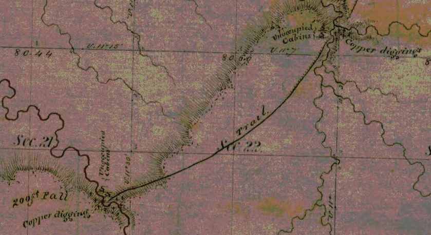
Detail from the Stuntz/Barber survey of T47N R14W.
“J.H. Bardon, a Superior pioneer, stated that ‘at Copper Creek and Black River Falls, twelve or fifteen miles south of Superior, and also near the Brule River, a dozen miles back from Lake Superior, Mr. Stuntz found evidences of mining and exploring for copper on a considerable scale carried on by the American Fur Company, under the direction of Borup and Oaks of La Pointe, in 1845-46. A tote road for the mines was opened from a point ten miles up the Nemadji River to Black River Falls.‘”
~ Duluth and St. Louis County, Minnesota; Their Story and People: An Authentic Narrative of the Past, with Particular Attention to the Modern Era in the Commercial, Industrial, Educational, Civic and Social Development, Volume 1, by Walter Van Brunt, 1921, page 66.
At Bad river we were at work during the coldest weather, and only lost two or three days because of cold but when the thermometer was up to 20* below zero we worked right ahead – sometimes in swamps where we stepped through the snow into the water,
[last line on this page of this copy is cut off]
The weather for a week or more has been fine. Cold enough to cover us with frost but not severe.
Provisions are very scarce – no flour or pork can be had.
They will begin to bring them through from St. Paul in a few days. Flour it is hoped can then be bought for $20 per barrel. Fish are not exactly plenty but they can be obtained for money or labor which is not the case with anything else. The country is flooded with dry goods, [p??y] articles and everything but provisions because they can be bought on time but eatables could only be got by paying cash down.
Geology of Wisconsin: Survey of 1873-1879,
Volume III, 1880, page 342[?].

Geology of Wisconsin: Volume 3, page 341.
Geology of Wisconsin: Volume 3, page 345.
The Fon du Lac mine has commenced operations with tolerable fair prospects. It is the only mine in operation this side of Montreal river. Augustus’ claim is on the same vein and for aught anyone knows just as good besides having abundance of water power. All the copper excitement since I come to the country has been directed toward the north shore. This morning I signed 2 petitions, one to congress for the early survey of the north shore and another for a road down that way. I have made a little map of the islands and last summers survey and some other things that I will enclose.
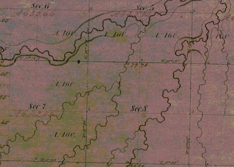
The Fond du Lac copper prospect was located near a small tributary of the Left Hand River on this map detail from T47N R14W, near Pattison State Park. Augustus’ claim was along the same vein of copper but had not been surveyed yet; perhaps it was at Amnicon Falls State Park.
Augustus has begun a letter to send with this. He has just come home with letters now about his claim.
No more at present from
Your affectionate son
J. Allen Barber
Direct to Lapoint
Minnesota Point
Superior County
Minn. Terr.
Sunday Feb 10th 1856
Dear Mother
Augustus has written a letter, and left it for me to enclose and dispatch so I thought I would ship in a few lines before sending it off.
Augustus started today with a young man and two dogs for Lapointe. I shall probably go there in a two or three weeks to return immediately. There are two men going down with a tamlins pony team with provisions from St. Paul for Augustus. The men are going to work for him and I shall probably bring the team back and use it a while. I have at last fixed my mind on a place that I mean to claim. The location is a point at the mouth of Left hand river, known as Left hand point. It contains only 5 or 6 acres in low & swampy and covered only with bushes coarse grass and floodwood. Nothing but the fact of its being a part of Superior city is of any value whatever.

Barber’s sketch of his land claim at the mouth of Left Hand River. This location is now an industrial neighborhood of Superior on the Nemandji River.
As it is $1,000.00 per acre is not an overestimate of its marketable price at present. It joins or is part of the grounds intended for the Railroad buildings when the survey was made here this point was cut off by the meander lines instead of meandered. Therefore according to the [rearns/records?] no such land exists.

A resurvey is to be made and I mean to fasten it by a preemption which is the only way to obtain it before the land sale. I may get cheated out of it and I may throw away my time and money but such chances are scarce and should it transpire that my claim is good I want to have my dish right side up for once. I have written for Uncle Allen’s advice and should I ever find it advisable to drop the matter I can do so without forfeiting my preemption right.
The Eye of the North-west, page 9.
The Superior Company with Company with which I shall probably have to contend is rich, influential, and on good terms with the administration. All that can be done by fair means or foul to defeat any claim will probably be done, but some things can be done as well as others, at any rate we shall see what we shall see.
So my head is so full of business just [snow?] you will please excuse the shortness of this letter and look for more when I have more time.
Your affectionate son
J Allen Barber
Superior Feb. 17th 1856
Dear Brother
It is sometime since I have written anything to you but you have heard of me so often that I suppose it makes no particular difference. It will be nearly sugaring time when you get this.

Makak: a semi-rigid or rigid container: a basket (especially one of birch bark), a box (Ojibwe People’s Dictionary) Photo: Densmore Collection; Smithsonian
I have once more got into a country where sugar is made but not by white men. The Indians make pretty good sugar which is generally done hard and [sinted?] dry and put into birch bark “mo’kucks” holding from 50 to 75 lbs. This bark is also used exclusively for buckets, store trays, gathering pails, &c. The timber in this country is not as equally distributed as in Vermont. The land is mostly covered with evergreens but there are some located portions of country where maple abounds. These “sugar bushes” as they are called are often quite extensive covering several sections and and [they?] only at intervals of 8 or 10 miles, but this is just as well for the Indians are both migratory and gregarious in their habits.
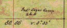
Detail of an Lake Superior Chippewa “sugar bush” from the Barber brothers’ survey of T48N R5W.
I hope you will eat plenty of sugar next spring and take some of the girls to a sugar party or two like I used to. I am doing nothing now most of the time but shall have business enough in a few days when I begin to build my house that is if I conclude to grab for the price of land I am now watching. I am waiting to hear from Uncle Allen and for some other things to transpire. There is not a man in the country whom I could trust that could give me any reliable information such as I want. I want you to hurry and become of age as soon as possible and come out here this spring and make a preemption.
There are some good places left yet, but don’t get married before you make a preemption for it might not be convenient to take your wife out into the woods 30 or 40 miles to live on the place as you would have to do in order to “prove up.” I am going to get up an ice boat before long which will be very useful as I mean to do considerable boating yet this winter, and I might use it to carry lumber and other things up and down the lake. With such winds as we have had a few days ago I could easily go to Lapointe and back in two days. I suppose Augustus got a party started by this time and he will be at it himself in a few days. I am living with a man named Fargo, you have heard of him before. We are living in Stuntz’ store. Board at the hotel is ten dollars per week. Old Steven Bonga is living on the point, he has been something of a traveller having been to Montreal, Hudson Bay, [Oregon?], Prairie du Chien, and all intermediate places.
He is half indian and half negro so you may suppose he is not very white.

Portrait of Stephen Bonga (USDA Forest Service). Additional information about Bonga is available from the Wisconsin Historical Society.
A railroad has been laid out from here to St. Paul and my claim covers the terminus at this end. There have two or three new towns started into existence along its route in imagination. Perhaps they are [surveyed?]. This making towns in a new country is a great business.
What happened in your good town on Christmas and New years eve
Were there any stockings left.
I want to inquire about lots of girls and boys in Johnson and Cambridge but I conclude you will tell me as much as you can in your next letter so with respects to all enquiring friends I remain
Your affectionate brother
Allen
Superior, Douglas Co. Feb. 25th 56
Dear Parents

Detail of Superior City from T49N R1W.
Night before last I got a letter and some papers from Augustus also 2 letters from home which he had read. They were dated Dec. [21st?] & Jan 2nd.
Sad and startling was the news of the death of George Hill. Who could have thought three years ago that such a dark future lay before that family. Every day some sad event warns me of the uncertainty of life. Men have died here who had no friends to mourn their loss, and their death is hardly noticed. I always ask myself why was it not me instead of them and will not my turn come soon. Yes, let it come soon or late as the world reckon, and it will be soon to me.
There is just as much danger or accidents in this country as in any other and no more but as to health there is no better place in the world than this. You seem shocked at the idea of surveying in the winter, but it will be nothing but fun to survey during the rest of the winter. It has been moderate pleasant weather now about two weeks. The snow is going off a little lately and it seems a little like spring. We had some pretty cold weather about new years but we shall have no more such. The lake is more open than it ever was known to be at this season before.
It sometimes freezes across at Lapointe but now it is open within six or eight miles of here. Flour is only $20 per bbl‑ with prospect of falling lower. The Indians chiefs have returned having only been to St. Paul where they found a letter telling them to delay their visit a while.
Poor creatures! They are fooled around by traders and speculators who are with the government in robbing and dwindling them. Any thing like a full account of their wrongs would astonish even them. About my claim I have not [???] today. There is another man after it and it will be no easy thing to carry my point.
Valuable property is troublesome stuff in this country. There is a townsight three miles from there now in litigation for which there is a standing offer of $200,000.
I am still living with Fargo on Minnesota point. I expect to go to Lapointe before long with Albert Stuntz who is going down with some supplies for Augustus which he brought from St. Paul.
It is too dark to write
Good bye
Allen
Superior, March 4th 56
Dear Parents
Not much has happened in this vicinity worth recording. The principle circumstances of note is the burning of a house and all the worldly possessions of a poor [Indian?].
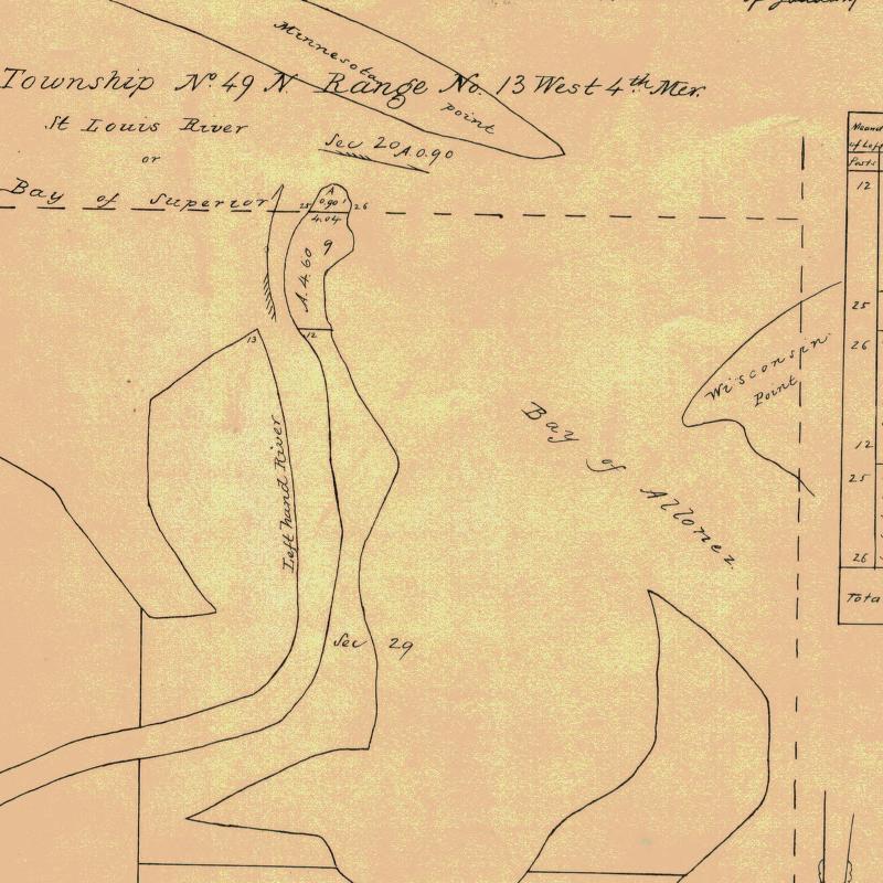
Detail of Left Hand River from Stuntz’s survey; where Barber’s land claim was located.
I have heard nothing of Augustus since writing last but expect to when anybody comes up the lake. About my claim I can say but little my chance is but dull still I don’t mean to give up so large a prize without good reasons.
I have had it surveyed and the notes sent to the Surveyor General with a memorial stating the facts and asking him to [appraise?] the [notes?].
The price contains over 8 acres (8.695).
Perhaps it occurred to you that I am was 22 years old last Sunday. Well such is unquestionably the case although nothing was done to celebrate the day only I had my hair cut for the third time after leaving Vermont. I think I shall have to go to Lancaster this spring but unless I get ousted here it will be difficult to leave.
I wish I could multiply myself by about a dozen in order to hold several valuable claims which are not occupied by any one who can legally hold them. I can’t write here two children [pretting?] and several people [telling?] Albert Stuntz and family are here today. I am perched on a sawhorse writing on a work bench loaded with all manner of [marbles?].
Evening – quiet once more since dark I have written a letter to the Surveyor General to accompany a memorial that I have been circulating. O I wish there was a person in the country that I could depend on to assist me in regard to that claim. There are one or two that I counsel with who know no more than I do and then I do as I think best.
I expect [Lowener?] to find out I have no show, and that will be the last of it I shall [not feel?] that I had lost it for I never had it, but if I don’t get it some body else will get 15 or 20 thousand dollars worth of land that I want.
Provisions are still high and will be higher again before navigation opens which cannot be expected before the 1st of May. Flour is $20/barrel, fresh pork 18 ¾ cents per lb, beef 20 cts milk 20 to 25 cts per qt. &c, &c. Eatables must be higher because there will be little or no sleighing after this over the barrens between here and St. Paul. My mind has been on the [rock?] so much today that I am not in a mood to think much about home so please excuse the shortness and dryness of this letter.
I remain your affectionate son
J Allen Barber
Went to Iron River Thursday 13
Returned 15th
Superior , Douglas Co. March 11 1856
Dear Parents
Yesterday I read a package of letters from Augustus containing one from him & from home one from Albe and one from [Caldridge?]. As Augustus was in town (Lapointe) when he recd. your letters I suppose he has answered them so I cannot tell you much news about him. I am still staying with Fargo – not doing much but hoping to get pay for my time and expense by securing the prize I am after. There is some excitement in town about it, but mighty little is said to me. The Register at the land office gives me good encouragement and says a preemption will hold it. I have taken some steps toward building on it. Today I bought a sack of flour ½ barrel for 12 dollars, I shall get some fish from Lapoint where they are very plenty and cheap and then I shall be almost ready to try housekeeping alone.

I am sorry to hear of the disastrous results of the low price of hops. Although farmers must suffer in consequence yet I believe speculators will make fortunes out of it. If I was in the business of raising them I should stick to it. No articles is so liable to fluctuations in prices as hops but it is well known that the risk fails once in five years on an average so they must come up sometime.
I see you are inclined to believe our country and climate are more in hospitable & forbidding than yours. Such I believe is not the case. We have had some very cold weather but the changes are so moderate and so seldom that we pay but little attention to the weather – in fact we call most all of it very fine weather, as it is. The lake is a great equalizer of temperatures and our cool lake atmosphere in summer causes showers to fall from all the warm, sweaty winds that come here to wash their faces in this big blue pond. People in this country go much better prepared for cold than they ever do in Vermont. I have not worn a boot since leaving Lancaster. We wear shoes in the summer and moccasins in winter.
Boots won’t do for surveyors – they carry too much water unless we stop to empty them after crossing every stream or marsh.
While speaking of clothes perhaps I might as well go on with a few more items of the same sort.
Shoes for this country should have no lining or binding as they are quicker and ae not as stiffwhen dry. We never apply anything to soften them and nothing can preserve them from wearing out in about two months of hard service. They [sell?] about $1.50 per pair. We can get plenty of wool hats which are the only ones we wear.
All manners of shirts can be bought, even the very best quality of red flannel ones, which are universally warm, outside, i.e. by common folks.
The gentry of Superior dress most distressingly.
It is difficult to get good socks any where on the country. I have worn out 6 or 7 pair this summer and lost some more – they cost high bests we don’t wear. I have none. The only cost I have is of [Gihon?] cloth and made by Mrs. Sheldon. Cost are not much more except as an extra garment to wear occasionally.
Good durable pants I find it difficult to get. They are generally poor [ashnet?] and not half put together. Good your mittens would be very acceptable but for want thereof buckskin or blanket mittens are generally warm.
You speak about bringing Kate [in?] to Wisconsin. My advice is to it without fail if you intend coming out to live, nothing should prevent it if I were in your place. The horse that Uncle [Jay?] brought out with him is smarter and tougher than any one he can find to use with him. There is nothing that I regard as more necessary for a family than a first rate horse. I think [Kelty?] will be a very good serviceable animal for work besides being one that you might be proud to ride [after?] over the prairies. Probably Augustus has told you what he thinks about Amherst and other boys coming out here to survey. Butler was so badly disappointed in this country that I have had but little thoughts of [enough?] any one else to come here. Such a disappointment I think would be the fate of 4 out of every 5 that try the business.
A person to be a surveyor must be able to travel all day through the woods and sometimes carry a pack. I would not prevent any from coming here as there is generally business enough besides surveying. A surveyor can make no greater mistake than by hiring any but the best of men. Perhaps Augustus has not told you that he will be out of the business as soon as his present job is done and will devote his time to the improvement of his claim &c. I should like very much to [have?] Amherst here but I dislike to have my parents left entirely alone. As I have [???] two half [sheets?] – when I only [illegible] mind up for the [present?].
[Incomplete copy of letter]
