Ashland, Wisconsin: Its Early Days
November 29, 2016
By Amorin Mello

Magazine of Western History Illustrated
November 1888
as republished in
Magazine of Western History: Volume IX, No. 1, pages 12-17.
—
ASHLAND, WISCONSIN:
ITS EARLY AND PRESENT DAYS.
—

Detail of Lapointe du Saint Espirit and Mission du Saint Espirit from Claude Allouez Map of New France, 1669.
~ Research Laboratories of Archaeology
If the reader will look at the map of the United States, he will see on its northern boundary the largest body of fresh water in the world – Lake Superior, called by the Ojibways Kitche Gumi, “The Big Water.” It lies between 46 and 47 degrees north latitude, and stretches east and west through eight degrees of longitude. Its coast-line is nearly two thousand miles in extent, forming some of the finest natural harbors in the world. Its surface is six hundred and thirty feet above the ocean level, while its bottom in the deepest parts is four hundred feet below the level of the tide-waters. As you come from the east end of the lake, St. Mary’s river, approaching its western extremity, you will, from the deck of the steamer, notice a group of beautiful islands – the same islands which, more than two hundred years ago, met the gaze of Fathers Marquette, Allouez and Mesnard, and which, in their religious zeal, they named the “Apostles’ Islands,” thinking that in number they corresponded with the number of our Savior’s disciples. One of these they named “Madeline,” from a favorite saint of their own “Belle France,” and to commemorate one of the most noted churches of Paris.

Detail of “The 12 Apostles” from Captain Jonathan Carver’s journal of his travels with maps and drawings, 1766.
~ Boston Public Library
These islands in ancient times were doubtless a part of the main, as was also the land now lying under Ashland bay. Underlying them was sandstone, rising from twenty to one hundred feet above the water, and horizontal. The great glaciers coming from the north, and moving in a southwest direction, cut channels in the sandstone, forming these islands, and scooping out of the solid rock the large basin which, in after years, received the name of Chaquamegon bay, and which is now known as Ashland bay. This was the first prophecy of the city of Ashland. In the times, millions of years before this, the vast deposits of iron ore had been upheaved and stored along the south shore of the lake, to subserve the designs of the Mighty Builder in the development of that commerce of which we now see but the earliest down, and of whose future extent we can form but a faint comprehension. Chaquamegon, Le Anse and Marquette bays are the natural outlets on Lake Superior for the rich mineral deposits which line its southern shore.
The formation of Ashland bay was therefore not accidental, but in harmony with Eternal plans. It is protected from the storms of the lake by a long, low, sandy point, and also by the Apostles’ islands. Into it open from the lake three broad channels, with a depth of water ample for the largest vessels, called the North, Middle and South channels. Under these islands, vessels coming from the wild storms of the open lake are secure. It is the sailor’s haven of safety.

1834 Map of LaPointe by Lyman Warren for the American Fur Company.
~ Wisconsin Historical Society
The first settlement on the bay was made by the American Fur company in the early part of the present century, on the beautiful Madeline island, and named La Pointe. It continued for many years the headquarters of a flourishing fur and fishing trade. About 1830 a Protestant and, soon after, a Catholic mission were established there, and churches built by them, in which devoted missionaries labored to Christianize and civilize the Indians whose homes were here and in the surrounding country. Here toiled Rev. Sherman Hall, a missionary of the American board, and Rev. L. H. Wheeler, and also that devoted man, now known to us as Bishop Baraga. These have all passed away. La Pointe, then the most populous and active village on the lake, is now, alas, “The deserted village,” and is visited alone in veneration of its past memories.

Map inset of Chequamegon Bay with Houghton, LaPointe, Bayfield, Ashland, and Bay City.
~ Wisconsin Historical Society
On the west shore of the bay, opposite La Pointe, is the beautiful town of Bayfield, founded by Honorable Henry. M. Rice in 1856. It is the terminus of the C., St. P., M. & O. railroad and the headquarters of a flourishing fish and lumber trade, and one of the most charming summer resorts on the lake.
On the west shore of the bay is also the flourishing town of Washburn – named in honor of Wisconsin’s governor, Cadwallader C. Washburn. It is the favorite town of the Omaha railroad, and has several large saw-mills, and is an active and enterprising town.

Asaph Whittlesey circa 1860.
~ Wisconsin Historical Society
The first settlement on the spot where Ashland now stands was made, in 1854, by Asaph Whittlesey and George Kilborn, both natives of the Western Reserve, Ohio. The lands were not as yet surveyed, so that they could not preëmpt them, and there was as yet no Homestead law. For this reason they, with Martin Beaser, then living in Ontonagon, Michigan, laid claim, under the “Town Site” law, to about three hundred acres, embracing their log houses and small clearing. They platted this into town lots in 1855, and subsequently were allowed to enter their lands as claimed, and in due course received their title. In February, 1855, Edwin Ellis, a graduate in medicine, in the University of the City of New York, of the class of 1846, came on foot through the woods from St. Paul to the bay. He had been engaged in the practice of his profession in his native state – Maine – till 1854, when, attracted by the prospect of wider fields for enterprise in the new west, and by the advice of Judge D. A. J. Baker, his brother-in-law, then living in St. Paul, he came to Minnesota.

Edwin Ellis, M.D.
~ Commemorative Biographical Record of the Upper Lake Region by J.H. Beers & Co., 1905, pages 16-18.
The years 1853 to 1857 were years of wild speculation. The states of Wisconsin and Minnesota especially were covered with rising cities – at least on paper. Fabulous stories of rich silver, copper and iron mines on the south shore of Lake Superior attracted a multitude of active young men from the eastern states. The city of Superior had been laid out, and its lots were selling for fabulous prices. The penniless young man of to-day became the millionaire to-morrow. The consequent excitement was great, and in the event demoralizing.
The Bay of Ashland, stretching far in-land, the known vast deposits of iron near the Penokee Gap, whose natural route to market was evidently by Chaquamegon bay, indicated with moral certainty that at its head would rise a commercial mart which should command a wide extent of country. The vast forests of pine were then hardly thought of, and no efforts made to obtain them. The lands were unsurveyed, and all the “squatters” were, in the eye of the law, trespassers. Nevertheless, the new-comers ran “spotted” lines around their claims and built log-cabins to hold them, and began to clear up the land. In June, 1855, Dr. Ellis went on foot to St. Paul, and thence to Dubuque, Iowa, and secured from the surveyor-general an order to survey four townships about the bay, embracing the site of the present city of Ashland. In the meantime, many settlers had come in and preëmpted lands in the neighborhood. In the fall of 1855 many of them were enabled to prove up and get titles to their lands.
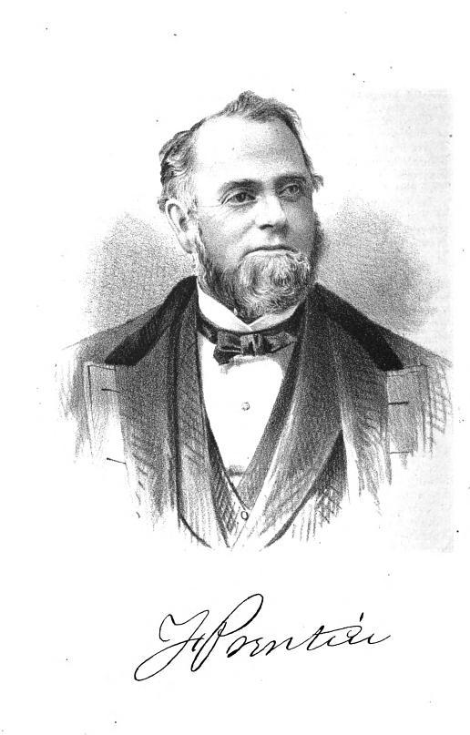
Portrait and biography of Frederick Prentice; the “first white child born in … Toledo.”
~ History of the Maumee Valley by Horace S Knapp, 1872, pages 560-562.
In the winter of 1855 Lusk, Prentice & Company, who had a trading-post within the present limits of Ellis’ division of Ashland, built a dock for the accommodation of the settlers coming to the new town. It was built of cribs, made of round logs sunk in the water about twenty feet apart. From one crib to another were stringers, made of logs, flattened on the upper surface, all covered with small logs to make a roadway. On the docks were piled several hundred cords of wood for the purpose of “holding” the dock from floating away, and to be sold in the summer to the steamboats which should come to bring supplies and begin the commerce of the town. The evening of the second day of April, 1855, saw the bay full of ice, slightly detached for a few feet from the shore, but with no sign of an immediate opening of navigation.

Portrait of Martin Beaser on page 24.
The next morning no ice was in sight, nor a vestige of the dock to be seen. Floating timber and cord-wood covered the bay. Till then the settlers had no idea the power of the floating ice moved by the tide of the bay. But they were not discouraged. The following winter two other docks were constructed – one by Martin Beaser, at the foot of what is now called “Beaser Avenue,” and the other by Edwin Ellis, near where Seyler’s foundry now stands.
These were also crib-docks, but the effort was made to anchor the cribs. There were no rocks to be had on the side of the bay where the docks were built, for which reason Mr. Beaser filled his cribs with clay, dug out of the banks. Dr. Ellis hauled stone across the bay, and filled as many of his cribs as possible, and on the top of the dock also piled several hundred cords of wood, and the settlers with anxious faces watched the departure of the ice. The shock came, and the docks afforded little resistance. The cribs filled with clay were easily carried. Those filled with stone stood better, but that part of those above water, and near the outer end, were swept away. The labors of many weary days and much money was thus swept away. There was, however, enough of the Ellis dock left to afford a landing to the few boats that came with supplies for the people.

Survey of Frederick Prentice‘s Addition of Ashland near the Gichi-wiikwedong village.
“It is in this addition, that, the Chippewa River and the St. Croix Indian trails reach the Bay, and for the purpose of accomodating the trade, already flowing in on their routes, a commodious store has just been built”
~ Wisconsin Historical Society
Translates as “Big Bay” in Ojibwemowin.
Traditional place-name for Ashland, WI.
Anglicized version of Gichi-wiikwedong.
Prentice Park and Maslowski Beach.
Area is famous for artesian wells.
“This was all Indian land then, but [Asaph] Whittlesey believed in take time for the forelock, looking he said, for a place that ‘might prove to be the most available point for a town, at or near Equadon (pronounced E Quay don, the second syllable emphasized.) The word ‘Equadon,’ is the Chippewa word meaning ‘settlement near the head of the bay.'”
~ The Ashland Daily Press, July 6, 1933, by Guy M. Burnham, reproduced on TurtleTrack.org. Read the full article for an interesting stories about how the town-site for Ashland was allegedly negotiated between Reverend Wheeler and Little Current.
During the years 1855, ’56 and ’57 many settlers had come to Ashland and built homes, and were all young men full of bright hopes for the future. In the spring of 1856 a township organization was formed, embracing more than forty townships of six miles square, and was called Bayport. The usual township officers were elected. The year 1857 opened with bright prospects. In Ashland streets were cleared and several frame houses were built. A steam saw-mill was begun and brought near completion. But in September of that year the great financial storm came, involving the whole country in ruin. The little village of Ashland was overwhelmed. The people had but little money, and in making their improvements had contracted debts which they could not at once pay. There had been so such speculation that the settlers had paid but little attention to the cultivation of the soil, depending upon supplies brought by water a thousand miles. We had no wagon roads nor railroads within three hundred miles. Winter was coming on, and many of the settlers – in truth, all who could get away – left the place. The few who remained saw hard times, whose memory is not pleasant to recall. Some of them, in making improvements, had assumed liabilities which well-nigh ruined them. If the county had then been organized for judicial purposes, so that judgements and execution could have been easily obtained, scarcely anyone would have saved a dollar from the wreck. But this fortunate circumstance gave them time, and their debts were finally paid, and they had their land left; but it then was without value in the market. Town lots in the village, which are now selling for five thousand to six thousand dollars, could then be sold for enough to buy a barrel of flour. The years following “’57” were hard years, and the settlers, one by one, moved away, so that in 1862 only two remained – Martin Beaser and Martin Roehn. In 1866 Mr. Beaser undertook to come alone from Bayfield to Ashland in an open sail-boat. It was a stormy day, and he never reached home. His boat was found soon afterwards at the head of the bay, and his body was found the following spring on the beach on the west side of the bay. Ashland was now left desolate and alone. Mr. Roehn, with a few cows, migrated backward and forward between Ashland and the Marengo river, finding hay and pasture for his cows, selling his produce and butter at Bayfield and La Pointe, and thus eked out an existence. The first railroad to reach Ashland was the Wisconsin Central, completed in 1877, connecting Ashland with Milwaukee. Work at the Ashland end was begun in 1872, and in 1873 finished to Penokee, twenty-nine miles south from Ashland. It had been built from the south to within about eighty-five miles of Ashland, and then came the panic of 1873, and all work stopped. The building in 1872 in Ashland was quite extensive, and village property sold at good prices, and everybody was hopeful. But the crisis of 1873 coming on, all enterprises at once stopped. Not till 1877 was the railroad completed. Its completion established Ashland on a substantial basis. In 1877 the Wisconsin Central company completed the Chaquamegon hotel, one of the finest in the country, which has added greatly to the attractions of Ashland.
The building of the Chicago, St. Paul, Minneapolis & Omaha road to this place, in 1883, gave a short outlet to the west and southwest, greatly benefiting the lumber trade.
The Northern Pacific, whose eastern terminus is at Ashland, soon after completed, gave it new importance as in the direct line of transcontinental commerce.
But the advent of the Milwaukee, Lake Shore & Western railroad had done more, perhaps to stimulate the growth of Ashland than any one of its great enterprises.
It runs northerly from Milwaukee to Manitowoc, where, turning in northwesterly course, it traverses vast tracts of valuable timber and farming lands, running for fifty miles along the Gogebic range – the richest iron region in the world.
This company has built two large and costly ore docks for the shipment of the vast amount of iron ore which it brings over its road.
South From Ashland
“The promoters decided to make Ashland the north end of their iron. It was a mere clearing, in the woods in 1870, formerly known as Equadon which was founded in 1854 and abandoned in 1863. The Ashland site was located on the bank of a splendid natural harbor called Cheguamegon Bay.”
…
“The clearing, grubbing and grading of the 30-mile Ashland-Penokee Gap Division had been practically complete in 1872. The iron rails were not laid into the Gap until October 1873, and there the railroad stopped for 4 long years.”
…
“Penokee Gap, 1000 feet above Lake Superior, is a break in the rough country, a regular gap where the Bad River breaks through the Iron Range Hills on its way to Lake Superior. The Gap is an historic pathway through which the copper workers from Mexico and South America came to Lake Superior centuries ago enroute to the copper deposits on Isle Royal in Lake Superior.”
~ History of the Soo Line, by James Lyden.
The Wisconsin Central Railroad company has also built a very fine ore dock, over which it ships the iron brought from the same range by its own line – the “Penokee Railroad” – built easterly along the northern base of the Gogebic range to Bessemer, in Michigan.
Notwithstanding the depression in the iron trade, more than a million tons of ore will be shipped from Ashland the present season.
Ashland has also two coal docks – one operated by the Ohio Coal company and the other by the Columbus & Hocking Valley Coal company – both of whom are doing a large business. The Lake Shore railroad and the Wisconsin Central obtain their coal for their engines, on the northern two hundred miles, by their docks at Ashland. The same rates for coal going west prevail as from Duluth and Washburn, and a large trade is springing up over the Omaha & Northern Pacific lines.
Ashland has three National and one private bank, all of which are conservative and carefully managed. It has also a street railway, two miles in length, with six fine cars and about forty horses, and is rendering very satisfactory service. We have also a “Gas and Electric Light Plant,” which affords abundant light for the streets, stores, dwellings and the ore docks. Ashland has also the Holly system of water-works, with about two miles of pipe laid, affording ample protection against fire and an abundant supply of water for domestic purposes. The pump-house has two ponderous engines, one being kept in reserve in case of accident.
As a point for the distribution of manufactured goods of all kinds, Ashland stands among the foremost. With practically the same rates as by the roads leading from Duluth west, it is prepared to compete with that lively town for part of the trade of the great northwest – now in its infancy but destined soon to attain great proportions; whose beginnings we can measure, but whose vast results we cannot now comprehend.
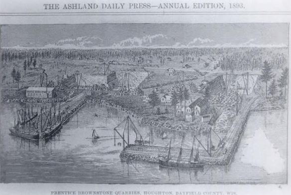
Portrait of Prentice’s brownstone quarries at Houghton Point.
~ Ashland Daily Press, circa 1893.
A Great Brownstone Industry Established At Houghton Point.
What Frederick Prentice Has Accomplished During The Season.“
~ Ashland Daily Press article in the Washburn Itemizer, October 18, 1888, reproduced on BattleAxCamp.tripod.com
One industry on Ashland bay is the brown stone, which exists along the water’s edge for many miles on the shore of the mainland and on the islands. It can be quarried in inexhaustible quantities within a few hundred feet of navigable waters of Lake Superior. It is of fine texture and beautiful color, and hardens by exposure. Large quantities have already been shipped and the demand is rapidly increasing. It can be shipped by rail at about four dollars per ton to Cincinnati. This stone, used for trimmings in buildings built of white brick, makes a very beautiful appearance.
The vast quantities of pine and hardwood timber in the vicinity of Ashland, and its advantages as a point of distribution for manufactured articles in wood, render it one of the best locations for manufacturing industries. For tanneries its location is unrivaled; the supply of hemlock bark is ample, while hides can be cheaply brought from Minnesota and the northwest, and the products can be shipped in all directions at low rates.
The schools of Ashland afford the best of opportunities for the education of our youth. Our school buildings are large, new and commodious, with all modern improvements. Our schools are graded and the attendance is large.
In the churches, most denominations are represented. The Catholic is the finest church edifice in the city, built of our own brown stone at a cost of over thirty thousand dollars. There are Presbyterian, Congregational, Episcopal, Baptist, Methodist, Lutheran and several Scandinavian churches.
As a summer resort, Ashland and the Apostles’ islands afford unrivaled attractions. Sail-boats, tugs and steamboats make daily excursions in all directions. They busy men from Chicago, St. Louis, St. Paul, Cincinnati and other cities can, in one day, escape from the sweltering heat and sleep on the cool ore of Lake Superior, and with our lines of railroad and telegraph stretching in all directons, they can be in constant and instant communication with their counting-rooms a thousand miles away. Its advantages in this line are already drawing many persons of wealth and leisure, as well as invalids, who come here to spend the hot season and at the close of the summer return home with new health and vigor.

Portrait of Edwin Ellis, M.D. on page 20.
Ashland has just two daily and three weekly newspapers, models of enterprise and very newsy, contributing much to the prosperity of the city.
The population of Ashland is about fifteen thousand, composed principally of persons under thirty-five years of age, and full of push and activity, who have come to stay and built up fortunes.
With all these and many other advantages Ashland seems to have a bright future, and many of us think it bids fair, in the near future, to become the second city in the state of Wisconsin. And we will labor that she shall be worthy of her rank.
EDWIN ELLIS.
An Incident of Chegoimegon
November 26, 2016
By Amorin Mello
This is a reproduction of “An Incident of Chegoimegon – 1760” from Report and Collections of the State Historical Society of Wisconsin: For the years 1877, 1878 and 1879. Volume VIII., pages 224-226.
—
AN INCIDENT OF CHEGOIMEGON – 1760.*
—
We have been permitted to extract the following from the journal of a gentleman who has seen a large portion of the country to the north and west of this place, and to whose industry our readers have been often indebted for information relating to the portion of country over which he has passed, and to transactions among the numerous tribes, within the limits of this territory, which tend to elucidate their characteristics, and lay open the workings of their untaught minds:

Detail of Isle de la Ronde from Carte des lacs du Canada by Jacques-Nicolas Bellin; published in Charlevoix’s Histoire et Description Générale de Nouvelle France, Paris, 1744.
Monecauning (abbreviated for “Monegoinaic-cauning,” the Woodpecker Island, in Chippewa language) – which is sometimes called Montreal Island, Cadott’s Island, or Middle Island, and is one of “the Apostles” mentioned by Charlevoix. it is situated in Lake Superior, about ninety miles from Fond du Lac, at the extremity of La Pointe, or Point Chegoimegon.
On this island the French Government had a fort, long previous to its surrender to the English, in 1763. It was garrisoned by regular soldiers, and was the most northern post at which the French king had troops stationed. It was never re-occupied by the English, who removed everything valuable to the Sault de St. Marie, and demolished the works. It is said to have been strongly fortified, and the remains of the works may yet be seen.
In the autumn of 1760, all of the traders except one, who traded from this post, left it for their wintering grounds. He who remained had with him his wife, who was a lady from Montreal, his child – a small boy, and one servant. During the winter, the servant, probably for the purpose of plunder, killed the trader and his wife; and a few days after their death, murdered the child. He continued at the fort until the spring. When the traders came, they enquired for the gentleman and his family; and were told by the servant, that in the month of March, they left him to go to their sugar camp, beyond the bay, since which time he had neither seen nor heard them. The Indians, who were somewhat implicated by this statement, were not well satisfied with it, and determined to examine into its truth. They went out and searched for the family’s tracks; but found none, and their suspicions of the murderer increased. They remained perfectly silent on the subject; and when the snow had melted away, and the frost left the ground, they took sharp stakes and examined around the fort by sticking them into the ground, until they found three soft spots a short distance from each other, and digging down they discovered the bodies.
The servant was immediately seized and sent off in an Indian canoe, for Montreal, for trial. When passing the Longue Saut, in the river St. Lawrence, the Indians who had him in charge, were told of the advances of the English upon Montreal, and that they could not in safety proceed to that place. They at once became a war party, – their prisoner was released, and he joined and fought with them. Having no success, and becoming tired of the war, they sought their own land – taking the murderer with them as one of their war party.
They had nearly reached the Saut de St. Marie, when they held a dance. During the dance, as is usual, each one “struck the post,” and told, in his manner, of his exploits. The murderer, in his turn, danced up to the post, and boasted that he had killed the trader and his family – relating all the circumstances attending the murder. The chief heard him in silence, saving the usual grunt, responsive to the speaker. The evening passed away, and nothing farther occurred.
The next day the chief called his young men aside, and said to them: “Did you not hear this man’s speech last night? He now says that he did the murder with which we charged him. He ought not to have boasted of it. We boast of having killed our enemies – never our friends. Now he is going back to the place where committed the act, and where we live – perhaps he will again murder. He is a bad man – neither we nor our friends are safe. If you are of my mind, we will strike this man on the head.” They all declared themselves of his opinion, and determined that justice should be rendered him speedily and effectually.
They continued encamped, and made a feast, to which the murderer was invited to partake. They filled his dish with an extravagant quantity, and when he commenced his meal, the chief informed him, in a few words, of the decree in council, and that as soon as he had finished his meal, either by eating the whole his dish contained, or as much as he could, the execution was to take place. The murderer, now becoming sensible of his perilous situation, from the appearance of things around him, availed himself of the terms of the sentence he had just heard pronounced, and did ample justice to the viands. He continued, much to the discomfiture of the “phiz” of justice (personified by the chief, who all the while sat smoking through his nose), eating and drinking until he had sat as long as a modern alderman at a corporation dinner. But it was of no avail – when he ceased eating he ceased breathing.
The chief cut up the body of the murderer, and boiled it for another feast – but his young men would touch none of it – they said, “he was not worthy to be eaten – he was worse than a bad dog. We will not taste him, for if we do, we shall be worse than dogs ourselves.”
Mr. Morrison, who gave me the above relation, told me he had it from a very old Indian, who was present at the death of the murderer.
* – This paper was originally published in the Detroit Gazette, Aug. 30, 1822. Hon. C. C. Throwbridge of Detroit, a resident of that place for sixty years, states that Mr. Schoolcraft, without doubt, contributed this sketch to the Gazette; that Mr. Schoolcraft, at the time of its publication, was residing at the Saut St. Marie: and Mr. Morrison, who was one of Mr. Astor’s most trusted agents at “L’Anse Qui-wy-we-nong,” came down to Mackinaw every summer, and thus gave Mr. Schoolcraft the information.
L. C. D.
Copper Creek Mining Location
November 18, 2016
By Amorin Mello

—
COPPER CREEK MINING LOCATION.
—
This location embraces the east half of the southeast quarter of Section 15, and the west half of the southwest quarter of Section 14, in Township 47, Range 14 west, being 160 acres in Douglas County, Wisconsin. It is about thirteen and one-half miles by the County road from the town and harbor of Superior, and at an elevation of 300 feet above the level of the lake.
The Aminecon Trap Range, in crossing it from southwest to northeast, is cut by Copper Creek, a rapid and never-failing stream, exposing at several points veins of native copper.
~ Mine Register: Successor to the Mines Handbook; Volumes 8-9, page 205.
“We all lived in the log house until December 31, 1845, when I left for Iron River [Michigan] under agreement to mine for the Boston North American Mining company, organized by the American Fur company, under the management of Messrs. Borup and Oakes.”
~ Michigan Historical Collections: Volume 2; page 688.
These surface exposures attracted, at an early day, the attention of the agents of the American Fur Company, then the only civilized occupants of that part of the country, and in the years 1846 and 1847 some attempts at mining were made under their direction. A particular description of their operations will be found in another part of this pamphlet. As they had no title to the land and were working at great expense in a region which was at that time wholly remote from civilization, it is not surprising that like many other pioneers in Lake Superior copper-mining, they abandoned their enterprise, or postponed it to a more convenient season.
Eight years afterwards, the whole southern shore of Lake Superior had ceased to be exclusively known to hunters and trappers. The land had been surveyed and brought into market, and settlement had extended to the extreme western end of the lake.

James H. C. McKinzey was issued his patent to the Copper Creek Mining Location by the Willow River Land Office on August 1st, 1854.
~ General Land Office Records
The Copper Creek location was then entered under a preëmption claim by J. H. C. McKinzey, and after a litigation at the Land Office with a rival preëmptor in the interest of members of the Fur Company (who now made a persistent effort to secure a title to the land), McKinzey’s claim was sustained, and a patent was duly issued to him. From him the title passed, with but one intervening link, to the present proprietor.
The location has been visited from time to time by explorers, practical miners, and geologists; numerous rich specimens have been taken from it, and it has long been reputed to be the most promising mining location west of Ontonagon. During the past season a regular exploration has been made upon it, with the view of ascertaining more definitely its value for mining purposes.
“This Township has a clay soil. The small streams are all muddy and go nearly dry in summer. A copper bearing trap range extends through the middle of Township. On the south side of these hills it is well timbered with valuable Pine Cedar Sugar & Black Ash. Copper has been obtained on the SE 1/2 of Section 21 & upon Sections 14 & 15. The streams [reaching?] into Black River are all very rapid.”
~ Wisconsin Public Land Survey Records
A Report of this exploration is presented herewith. Mr. George R. Stuntz, under whose superintendence it was conducted, is an explorer of great experience, with a knowledge of the geological formations characteristic of the copper-bearing districts of Lake Superior, acquired by careful study in the field. He was the original surveyor, under government contract, of the whole Wisconsin shore of the lake, and has, perhaps, a more thorough acquaintance with that region than any person could be named. His Report is a plain statement of facts, and as the undersigned was himself present and taking part in the exploration, he is able to vouch for its accuracy. In connection with the maps, and with the specimens to which it refers (which were marked and packed on the ground by the writer’s own hand), it will furnish a correct idea of the character of the location.
It will be seen that there are three well-defined veins, two of which, including the one from which the richest specimens were obtained, run with the formation. This last mentioned lode rests upon a foot-wall of the most productive veins of the Minnesota mine. Although only three veins have been actually traced, there is reason to believe that others would be discovered by a further exploration, as many points inviting examination were passed by, owing to the lateness of the season.
Detail from George Riley Stuntz’s original survey map of Township 47 North, Range 14 West: copper mines, abandoned cabins, and a tote road in what is now Pattison State Park. The northeast feature is Copper Creek and the southwest feature is Big Manitou Falls.
~ Wisconsin Public Land Survey Records
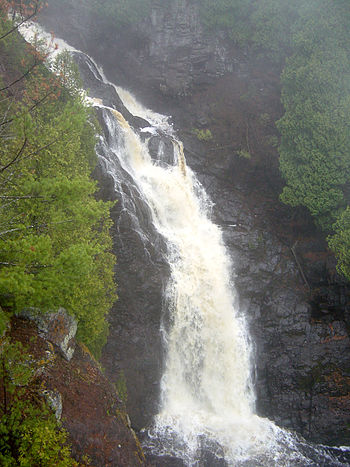
“Big Manitou Falls, the tallest waterfall in Wisconsin, in Pattison State Park just south of Superior, Wisconsin, USA.” Photograph from
Bobak Ha’Eri shared with a Creative Commons license.
The facilities furnished by Copper Creek for stamping purposes will be apparent from an inspection of the map. The town of Superior, having a good harbor, with piers and warehouses, erected by private enterprise, presents every convenience for shipping copper and obtaining supplies. Beef cattle, driven over from Minnesota, on the military road, can be purchased here much cheaper than at the Michigan mines, which are now largely supplied from this point. Pork can be advantageously procured in the same way. Another advantage is found in the price of lumber, an article for which the pineries and sawmills in this region now find a market at the lower mines. One of the finest bodies of pine in the north-west is found on the Brulé and Iron Rivers, about twenty-four miles east of this point.
With reference to the transportation between Superior and Copper Creek, it may be mentioned that, besides the wagon road (which is now available during the winter, and at no great expense can be made so at all times), the Nemadji River which, at ordinary stages of water is navigable for small boats to a point within four miles of the location, affords an additional route.
There is reason to believe that the whole country at the westerly end of Lake Superior will receive a new stimulus to its development before many years, by the opening of railroad communication with the Mississippi River, an enterprise which is becoming the absolute necessity to the interests of Minnesota. Meanwhile communication is kept open by means of the Point Douglas military road and a regular line of stages between St. Paul and Superior, which place is thus rendered accessible at all seasons.
JAMES O. SARGENT.
Boston, Dec. 8th, 1863.
—
REPORT OF EXPLORATION.
(ACCOMPANYING SPECIMENS.)
—
Superior, Oct. 17, 1863.
JAMES O. SARGENT, ESQ.
SIR : Under instructions from you, I have made a survey of the east half of the southeast quarter of Section 15, and the west half of the southwest quarter of Section 14, Township 47 north, Range 14 west, in Douglas county, Wisconsin, and have explored the same as thoroughly as the limited time and the small force under my direction would permit.
I herewithin submit a copy of the field-notes of the survey, and a map of the location.
In making the exploration I had the services of Mr. George Walker, an English miner, who has had several years’ experience in the various copper mines on this lake.
The tract is thickly timbered with spruce, fir, aspen, sugar, oak, white pine, and birch. This timber is small in size.

The Aminecon Trap Range crosses the location. This Range makes its appearance above the sandstone on the east side of Township 48 north, Range 12 west, about the middle of the township, runs in a southeasterly course across the township, and across Township 47, Range 13, Township 47, Range 14, Township 46, Range 15, and leaves Wisconsin. It is cut by the Aminecon River, Copper Creek, and Black River, and numerous small streams. Throughout the extent described it gives promise of being a productive mining district.
Two small streams unite near the centre of the location, forming Copper Creek, which runs in a northwest direction, and leaves the tract about twenty rods south of the northwest corner. Owing to the extremely dry season, this stream was lower at the time of my examination than it has been known to be in ten years; but it affords at all times abundance of water for the purposes of a mine employing steam power.
By a measurement, taken October 1st, I found the amount of water passing through it to be 58 5/10 cubic feet per minute, and this is very much below the average. In ordinary seasons the amount of fall in the stream (which is from fifty to a hundred feet within the location) would give a water power sufficient for all the purposes of a mine.
From my examination I believe that there are three veins, as represented in the map, in all of which we obtained native copper.
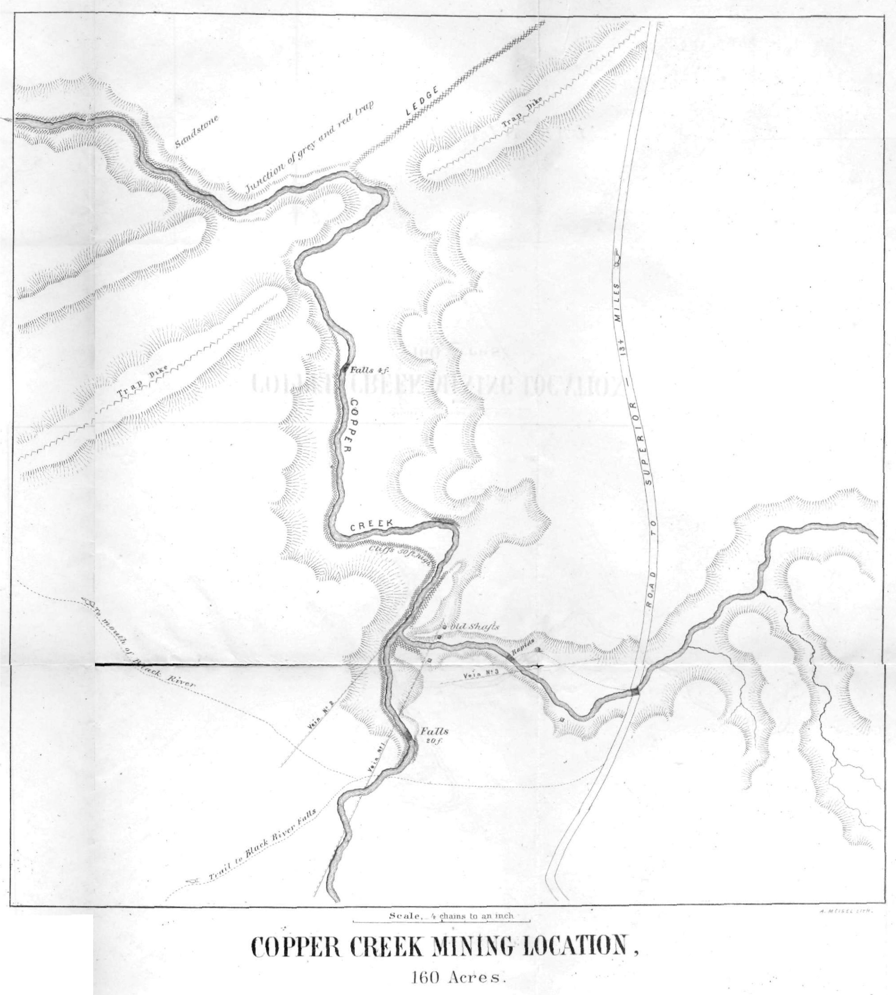
Vein No. 1 shows a breast in the east bank of the west branch of the stream, of nearly twenty feet wide, and bears south twenty-four degrees west. The specimens taken from this locality are numbered, and, as you will perceive, exhibit a quality of vein-stone which gives promise of productiveness. This vein has been traced to the southwest and adjoining location. It dips to the southeast at an angle of thirty-three degrees. The productive part of the lode lies upon the foot-wall, specimens of which I furnish with this Report, as also of the hanging wall.
Vein No. 2 shows a breast of over thirty feet in the bluff east of the stream, and appears to run in a northeast course. My explorations were not carried far enough to fully define its course in that direction. Surface specimens of the vein and of the adjacent trap are furnished herewith.
Vein No. 3 cuts the east branch of the creek, and bears north eighty-two degrees east. We opened this vein in four places at the creek, within two hundred feet. It has the appearance of being very much disturbed. On the west side of the stream, it is very compact and filled with quartz-lined cavities interspersed with crystals supposed to be malachite. It dips to the northwest. Specimens from this locality, a full collection of which is furnished, warrant a more thorough examination.
Vein No. 2, before referred to, as showing a breast of thirty feet in the east bluff, appears to branch or to be thrown out about eighty feet in crossing the creek bottom; my limited time and means did not permit me to determine which.

About two hundred feet below the junction of the two branches of the creek it shows at the foot-wall in the bed of the stream. A few feet west of this, the lode rises in the bluff on the west side of the stream. Course of stream at this point north twenty-eight degrees east. Course of vein north forty-two and one-half degrees east. At this junction of the streams, the lode, stripped of its hanging-wall, rises to the top of the cliff, a height of forty or fifty feet. At this point, we blasted into the lode, and found it rich in copper, some pieces weighing from six to fifteen pounds, and with rich stamp-work. See specimens marked Vein No. 2, west of stream.
About fifty feet above the forks of the stream the lode rests upon a bed of conglomerate. This conglomerate is highly metamorphosed, and is amygdaloidal. See specimens.
About one hundred feet west of this, we opened the vein on the brow of the hill. It there shows a breast of twenty feet, and dips to the southeast at an angle of thirty-five degrees.
~ Duluth and St. Louis County, Minnesota: Their Story and People; Volume 1, page 66.
This location was worked to some extent in the years 1846 and 1847, under a lease from the General Government, by the American Fur Company. They sunk four shafts, but appear to have done very little surface exploring.
Three of these shafts are sunk on the course of Vein No. 1, and from my examination appear to have been perpendicular. Their location is given on the map. The timbering is so much decayed that I did not venture to work in them. From soundings, I found the shaft between the streams forty-six feet deep, the next one on the east side of east branch twenty-eight feet deep, and the one east of section line twenty-eight feet deep. All of them have water to within about twelve feet of the surface. The fourth shaft is sunk at the bend of the east branch. This is thirty-five feet deep, and does not appear from the burrow to have been upon any vein.
The first three shafts above described were sunk perpendicularly upon the outcrop of a vein dipping thirty-three degrees, and therefore pass into a foot-wall. Had they been continued, they would have cut Vein No. 2. They may perhaps be made available in a further exploration.
Upon the adjoining location, to the westward, is a vein discovered by John Parry, some years ago. I have taken some specimens from it which are herewithin furnished. This vein runs north eighty-two degrees east, and intersects your western boundary six chains north of the southwest corner. It appears to be a continuation of Vein No. 3.
At the junction of the trap with the sandstone, in the northwest corner of the location, in the bed of Copper Creek, a bed of bluish-white grindstone grit of first-rate quality is found. The layers are from one inch to several inches in thickness. This white sandstone appears to belong to a different period from the red sandstone of Lake Superior. It only shows to the height of a few feet, and is overlaid by sixty feet of the red sandstone.
In the vicinity of the trap dike it is bent and fractured and considerably hardened. Near the junction, as marked on the map, it is tilted until some of the layers stand perpendicular. There are no ripple-marks on this white sandstone, while the red, resting upon it, shows evidence of a strong current.

Portrait of George Riley Stuntz from The Eye of the North-west: First Annual Report of the Statistician of Superior, Wisconsin, by Frank Abial Flower, 1890, page 26.
This tract of land is thirteen and one-half miles from the town of Superior, at the west end of Lake Superior. It is on a County Road which has been nearly completed, is now practicable for winter use, and can be made a good summer road at an expenditure not exceeding $2,000.
The soil is a sandy loam, with a subsoil of red clay containing a large per centage of marl, and is quite productive, being capable of producing a large portion of the vegetables needed by the operatives at a mine. It is especially adapted to the cultivation of grass and oats. Timber for lumber and fuel can be obtained conveniently and in unlimited quantity.
