1854 Treaty Lands at Apostle Islands National Lakeshore
March 20, 2026
Collected & edited by Amorin Mello
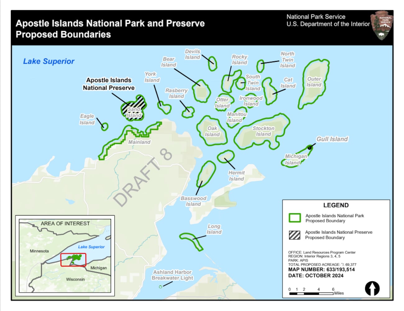 The Chequamegon area’s Apostle Islands National Lakeshore has been in the news lately due to the reintroduction of Congressman Tom Tiffany’s proposed Apostle Islands National Park and [Sand Island] Preserve Act. This proposed Act has been controversial due to strong opposition from local governments citing lack of consultation and insufficient infrastructure, among other concerns.
The goal of this post is to raise awareness about how the current Apostle Islands National Lakeshore contains roughly 3,000 acres of tribal lands reserved by the 1854 Treaty of La Pointe, and should consider returning these tribal lands back to the Lake Superior Chippewa before making any changes to become the proposed Apostle Islands National Park and Sand Island Preserve.
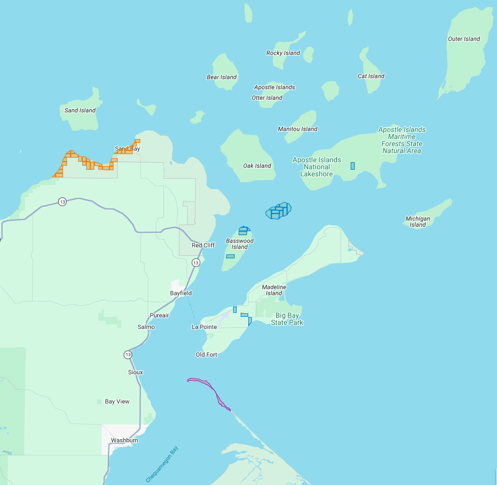
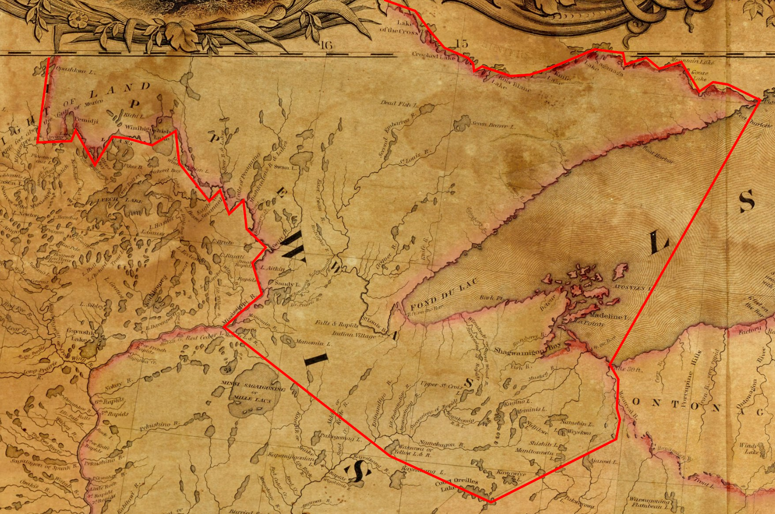
The current Apostle Islands National Lakeshore contains 3 types of lands reserved by the 1854 Chippewa Treaty of La Pointe:
29 Allotments (red) within the Red Cliff Reservation,
14 Allotments (blue) on Stockton, Hermit, & Basswood Islands,
and the disputed Bad River Reservation (purple) on Long Island.
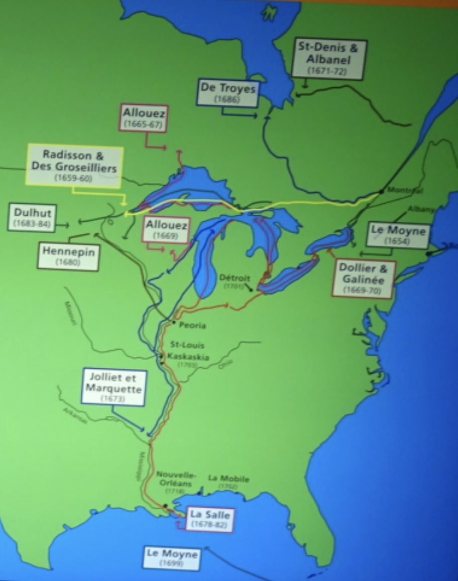
All of the Apostle Islands are part of the ceded territory from the 1842 Treaty of La Pointe covering roughly 22,000 square miles in northern Wisconsin and Michigan. The historical context of this 1842 ceded territory was to allow Americans to move into copper-rich areas while still retaining hunting, fishing and gathering rights for the Lake Superior Chippewa on those same lands. In modern context, this 1842 ceded territory has natural resource managed jointly between the States of Michigan and Wisconsin, the Lake Superior Chippewa, and Great Lakes Indian Fish & Wildlife Commission (GLIFWC).
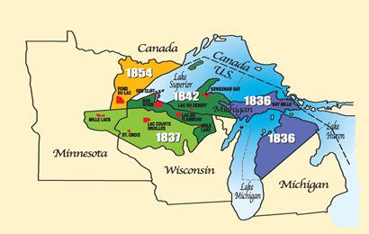
Map of 1836, 1837, 1842, and 1854 ceded territories jointly managed by the Great Lakes Indian Fish & Wildlife Commission (GLIFWC).
The 1854 Treaty of La Pointe reclaimed certain lands within the 1842 ceded territory to be reserved as permanent homelands for the Lake Superior Chippewa Bands in the form of Reservations and Allotments. For more information, we have covered the debates and circumstances leading up to the creation of these Reservations and Allotments in great detail on this blog, such as the Sandy Lake Tragedy and Ojibwe Removal events. Unfortunately much of those Reservations and Allotments have become “checkerboarded” or alienated from the Lake Superior Chippewa despite the original intention of being permanent homelands.
In this post we will examine roughly 3,000 acres of those Reservations and Allotments from the 1854 Treaty of La Pointe that are contained within the Apostle Islands National Lakeshore today. For clarification, there is a Reservation and several Allotments on Madeline Island, which are outside of the Apostle Islands National Lakeshore and will be discussed at a later date instead of in this post. Nor are we including any of the 1887 Dawes Act Allotments on the Apostle Islands in this post, because they are not from the 1854 Treaty.
Without further ado…
Zaagawaamikong-neyaashi
(roughly translated as “long soft beaver dam point”)
a.k.a. Chequamegon Point and Long Island
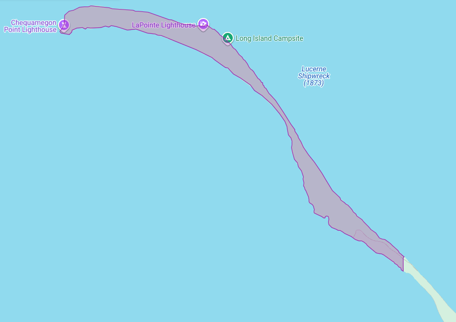
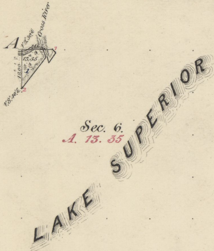
The Apostle Islands National Lakeshore contains Chequamegon Point (roughly 300 acres) on Long Island located at the Bad River Reservation (a.k.a. Mashkiiziibii).
Currently, federal maps of Long Island depict Chequamegon Point to lie outside the Bad River Reservation boundaries. Ownership of Chequamegon Point has been disputed between Bad River and the Federal Government for many generations since the 1854 Treaty.
This dispute is based on how the Second Clause of the Second Article of the 1854 Treaty of La Pointe defined the boundaries of the Bad River Reservation to follow “along the lake shore, crossing Shag-waw-me-quon [Chequamegon] Point, to the place of beginning“. In recent years, Bad River has been conducting a Historical Background Study about the 1854 Treaty of La Pointe and the Chippewa understanding of how they negotiated with Federal negotiators to include Chequamegon Point in Bad River’s lakeshore reservation boundaries.
We have mentioned this ongoing dispute in past posts, and will continue to examine historic records in support of Bad River’s efforts to repatriate tribal ownership of Chequamegon Point.
Gaa-giishkidaawangaa-wiikwedong
(roughly translated as “sand bay”)
a.k.a. Sand Point, Sand Bay, and Little Sand Bay
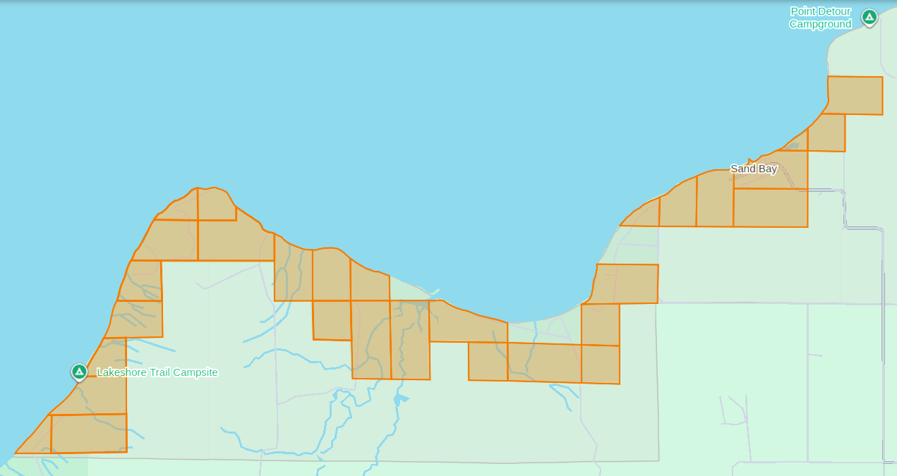
The Apostle Islands National Lakeshore’s Mainland Unit contains 29 Allotments (roughly 1,550 acres) located at the Red Cliff Reservation (a.k.a. Gaa-miskwaabikaang). The Sand Bay shoreline contains three Allotments (uncolored) that are owned by Red Cliff.
The media often cites the 1887 Dawes Act when describing how Allotments on the Lake Superior Chippewa Reservations became alienated from tribal ownership. That is factually incorrect, because these Allotments came from the 1854 Treaty of La Pointe, which precedes the 1887 Dawes Act by several decades. The key difference here is how these 1854 Chippewa Treaty Allotments were designed to reserve tribal land that would never be taken away later, while the later 1887 Dawes Act Allotments were designed to be alienated/sold after a period of 25 years. Unfortunately the 1854 Treaty Allotments were mismanaged by non-tribal governments as being temporary instead of permanent.
This mismanagement has caused much damage over time in the form of “checkerboarded” tribal land bases, which explains the legacy of how these 29 Allotments inside the Red Cliff Reservation fell out of tribal ownership and became part of the original boundaries of the Apostle Islands National Lakeshore.
In 1970, two additional Allotments along the Sand Bay shoreline were targeted to become part of the original boundaries of Apostle Islands National Lakeshore, but ultimately never became alienated from tribal ownership. Today these two Allotments still remain excluded from the boundaries of the current Apostle Islands National Lakeshore and proposed National Park.
In 2018, a third Allotment along Sand Bay that had fallen out of tribal ownership due to “checkerboarding” was repatriated from Town of Russell ownership back to tribal ownership, and is now a Tribal Management Unit of the Apostle Islands National Lakeshore.
The proposed boundaries of the Apostle Islands National Park and [Sand Island] Preserve Act contain this repatriated Allotment, but not the two Allotments that were never alienated from tribal ownership.
Wiisaakodewan-minis
(roughly translated as “half-burnt wood island”)
a.k.a. Stockton Island or Presque Isle
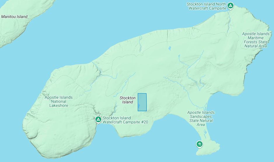
The Apostle Islands National Lakeshore contains one allotment (roughly 80 acres) on Stockton Island:
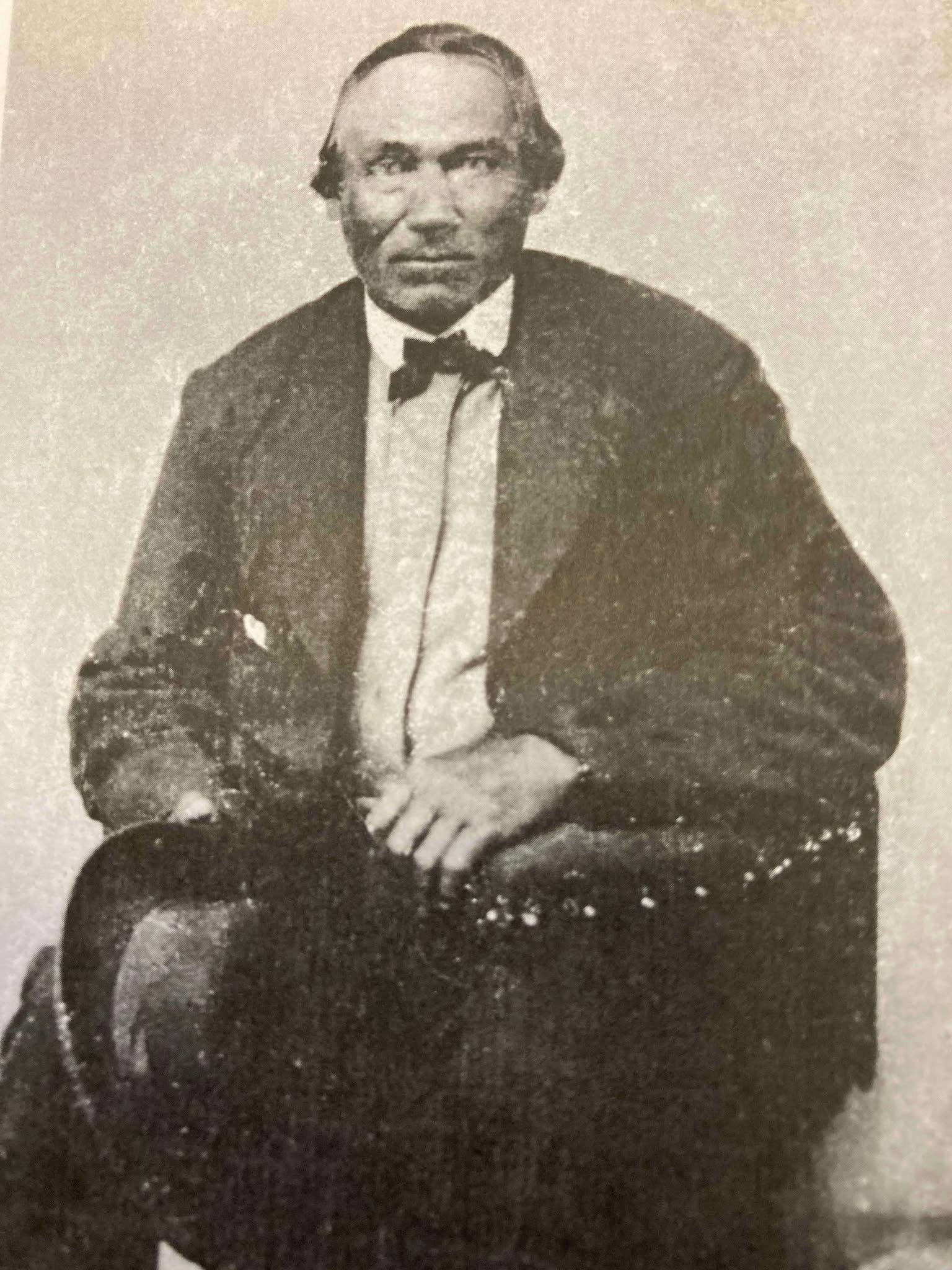
1) Joseph Gauthier (a.k.a. Gokee) Senior
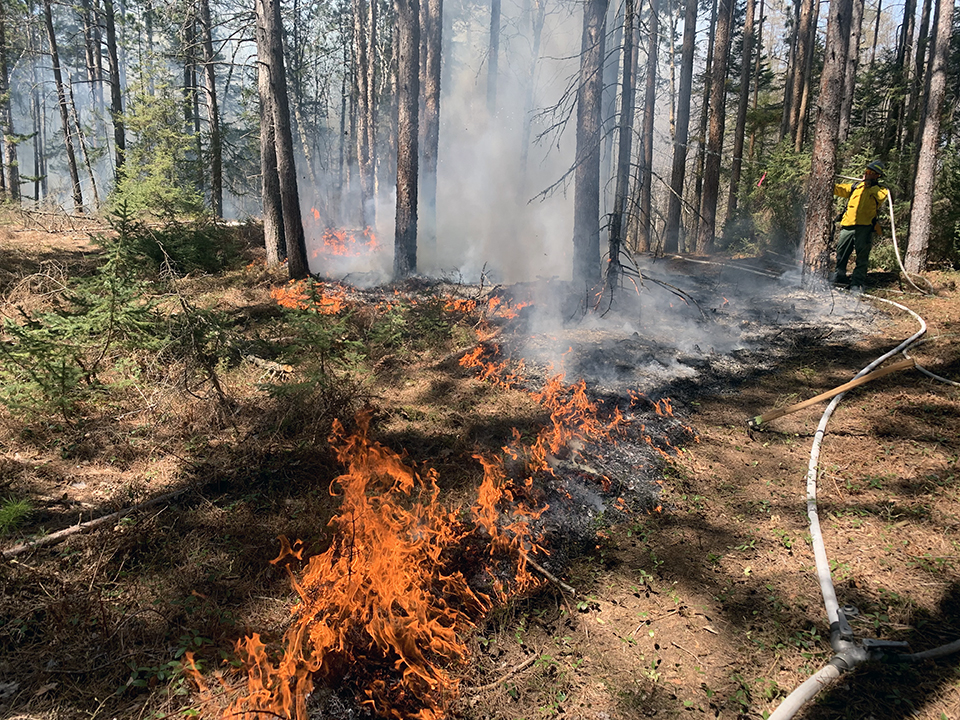
A prescribed fire on Stockton Island conducted by National Park Service and Tribal partners.
~ Photo by Dave Cooper at NPS
The root word of island’s traditional name, Wiisaakodewan (half-burnt wood), refers to Stockton Island’s historic appearance of being partially burnt. In recent years, the Apostle Islands National Lakeshore and the Lake Superior Chippewa have jointly reintroduced the practice of using prescribed fire management to promote the growth of blueberries and other traditional ecological resources on the cultural landscape of Stockton Island.
Wiisaakodewan also happens to be the root word of a pejorative slang term describing the Mixed Blood people of Lake Superior Chippewa. At the time of the Treaty Era, the Mixed Bloods of the Lake Superior Chippewa held a strong connection to this island via the tribal fishing industry. For example, the surveyor Joel Allen Barber described how “the bays on Presque Isle [Stockton Island] are a favorite resort of fishermen” in connection to the tribal fishing grounds of the La Pointe Indian Reservation on Madeline Island’s north end.
Wiigobiish-minis
(roughly translated as “basswood island”)
a.k.a. Basswood Island
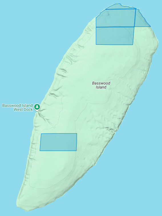
The Apostle Islands National Lakeshore contains four allotments (roughly 290 acres) on Basswood Island:
1) John Baptist Berriot
2) Henry Bresette (a.k.a. Brisette)
3) John Baptist Lemieux
4) Louis Neveaux
In a previous post we briefly mentioned that the infamous John Breckenridge made national news with his land speculation on Basswood Island immediately following the 1854 Treaty of La Pointe. In a few short years Breckinridge would become Vice President of the United States, and also a Confederate States Army brigadier general during the Civil War.
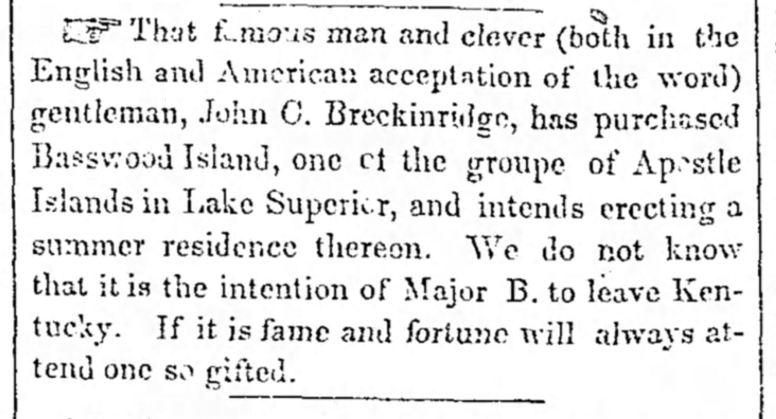
The Louisville Daily Courier [Kentucky], August 14th 1855, Page 4.
Eshkwegwindeg-minis
(roughly translated as “floating at the end or behind island”)
a.k.a. Hermit Island
f.k.a. Austrian Island
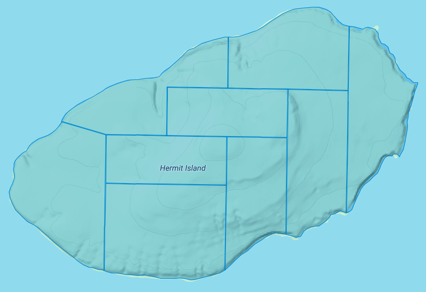
The Apostle Islands National Lakeshore contains nine allotments (roughly 780 acres) covering all of Hermit Island:
1) Josette Deefoe (a.k.a. Defoe)
2) Michael Defoe
3) Francois Dejadin (a.k.a. Artishon) Junior
4) Charles Dingley
5) Mary Dingley
6) Mary DuBay
7) Louis Gaudin (a.k.a. Gordon)
8) John Baptist Goslin (a.k.a. Gauslin)
9) Elizabeth (a.k.a. Isabella) Tremble
The traditional name of Eshkwegwindeg appears to be referencing this island’s location between the mainland and several other Apostle Islands. Today it still remains a central hub between the Red Cliff Reservation, the La Pointe Reservation on the north end of Madeline Island, and the other Apostle Islands with Allotments. It is noteworthy how the entirety of this Island is covered by Allotments, unlike the other aforementioned Islands.
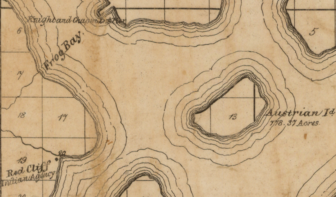
Austrian Island on Asaph Whittlesey’s 1871 map of Apostle Islands and Harbor of Bayfield and Its Surroundings.
~ Wisconsin Historical Society
Modern maps call this Hermit Island in reference to the colorful story of how William Wilson was ostracized from La Pointe and relocated to this Island to live out a solitary life during the Treaty Era. The famous “brownstone king” Frederick Prentice‘s connection to this Island in later decades is also a popular story being told by tour guides in modern times. However, I personally am more interested in exploring the history of how this Island was know as “Austrian Island” between the Wilson and Prentice eras, because it illustrates Julius Austrian’s abuse of Allotments to take private ownership of what should be tribal lands for personal profit.
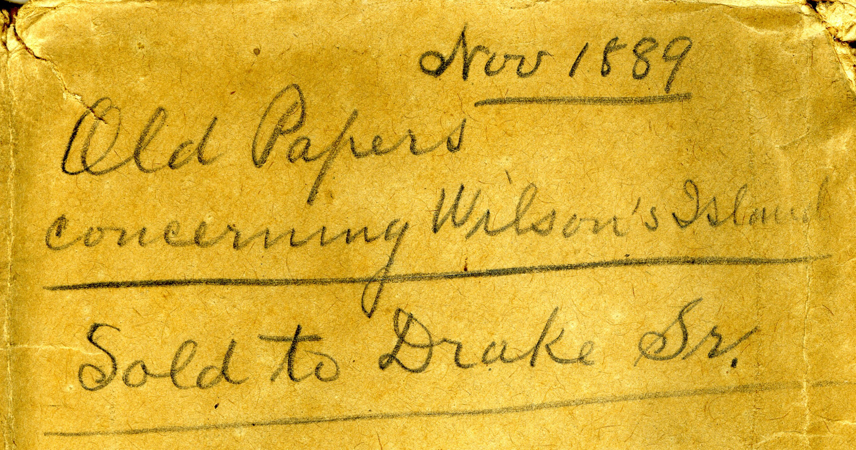
Madeline Island Museum
JULIUS AUSTRIAN PAPERS (2011.158.A) Folder 5:
PAPERS RELATING TO WILSON’S ISLAND (HERMIT ISLAND IN THE APOSTLE ISLANDS ARCHIPELAGO), WISCONSIN (1870-1888)
Julius Austrian’s corporate letterhead circa 1888 advertising Allotments for sale.
I personally became very interested in Chequamegon history specifically because of Julius Austrian and his abuse of Allotments to take private ownership of what should be tribal lands in the Penokee Mountains for personal profit, and how that legacy evolved to become what is still known as the La Pointe Iron Company today.
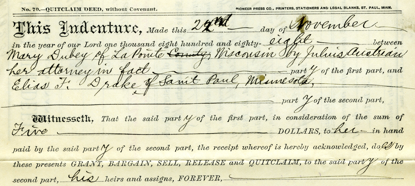
Example of Julius Austrian using Power Of Attorney to buy Mary DuBay’s Allotment for $5 so he could later flip it for profit as private property.
Austrian’s land speculation on Hermit Island follows the same trend of using Allotments via power of attorney over Mixed Blood tribal members of the Lake Superior Chippewa to grab ownership of prime real estate before other land speculators. In the Penokees example, Austrian gave each Mixed Blood $100 to sell their Allotments via Power of Attorney, but here we see how Austrian gave Mary DuBay only $5 for her Allotment on Hermit Island.
My research has been the foundation of academic research in Larry Nesper’s book Our Relations…the Mixed Bloods, and I will continue to post more on this topic in the Austrian Papers on this website.
So what?
Regular readers of Chequamegon History know that my writing style is to post historic documents enhanced with multimedia and sidebars, but omit my own interpretations and and just let readers reach their own conclusions. Leo, on the other hand, is more inclined to speak out about the implications, such as in his posts 19th Century Deer in the Headlights and Slavery, Debt Default, and the Sandy Lake Tragedy. However, in this case, due to Congressman Tom Tiffany’s ongoing efforts despite strong opposition from local governments, I felt it was important to expound on this issue a bit more than I usually do.
Righting a Wrong: Restoring Lands to the Leech Lake Band of Ojibwe
In 2020, the Leech Lake Band of Ojibwe Reservation Restoration Act (Public Law 116-255) returned approximately 11,760 acres of allotted lands wrongfully taken by the Chippewa National Forest back to Tribal ownership and management. The same concept should be applied to repatriate tribal lands in the Apostle Islands National Lakeshore before moving forward with the proposed Apostle Islands National Park and Preserve Act.
Lac Court Oreilles Band of Lake Superior Chippewa v. Walker, Evers
Tribes of the 1854 Chippewa Treaty in Michigan and Wisconsin have won two important lawsuits in recent years due to the fact that their tribal lands should have been reserved under the 1854 Treaty of La Pointe instead of becoming “checkerboarded” from illegal taxation/foreclosures.
Red Cliff Band of Lake Superior Chippewa Indians v. Bayfield County
What started off as a dispute about zoning authority over tribal lands has developed into a constructive partnership. Bayfield County and Red Cliff have developed a Memorandum of Understanding that has led to repatriation of tribal lands within the Red Cliff Reservation. This has led to 2,500 acres being returned by the County to Red Cliff in recent years, with the last 900 acres being completed in 2022.
While returning all County-owned surface rights within the Reservation back to the Tribe has been a tremendous achievement, the County still owns mineral rights within the Red Cliff Reservation. Mineral rights supersede land rights under Wisconsin law, so more work still remains to be done in these land repatriation efforts between Bayfield County and Red Cliff.
Bayfield County should promote their efforts in recent years to help Red Cliff repatriate 2,500 acres of County-owned lands back to tribal ownership, and encourage the Apostle Islands National Lakeshore to return their 3,000 acres of Reservation/Allotments back to tribal ownership.
Frog Bay Tribal National Park
Congressman Tom Tiffany claims that his proposed Apostle Islands National Park and Preserve Act would create the first National Park in Wisconsin. However, Red Cliff already earned that claim to fame in 2012 by establishing the Frog Bay Tribal National Park through an innovative partnership to repatriate Allotments on their Reservation from non-native landowners.
We would much rather see the establishment of a Sand Bay Tribal National Park in Red Cliff, a Chequamegon Point Tribal National Park in Bad River, and Tribal National Parks for the Apostle Islands Allotments, before the proposed Apostle Islands National Park and Preserve. Ultimately these Tribal Lands should be returned to the Lake Superior Chippewa and let them decide whether to manage them as Tribal National Parks or not.
Ruelle Chagouamigon du Vieux-Montréal
October 25, 2025
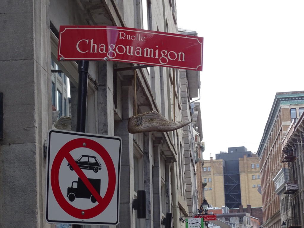
Photo taken by David Trudeau at Ruelle Chagouamigon, 2019.
A Street named for Chequamegon in Montreal.
Guest post by David Trudeau
French North America at the dawn of the 18th century was a vast network of French and Indigenous trading outposts spanning the entire Mississippi and St. Lawrence-Great Lakes watersheds with Montreal as its main hub. Chequamegon was a part of that network, and so notable, that a street in old Montreal was called “Rue Chagouamigon.”
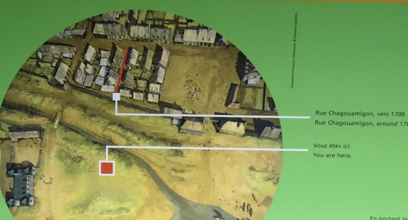
Model of Rue Chagouamigon circa 1700. Photo taken by David Trudeau at the Pointe-à-Callière Museum, 2019.
Madeline Island is approximately 1200 miles from Montreal, a journey of about 6 hours by plane — or one of up to two months by canoe and portage across Superior and Huron and down the Ottawa river. In the days of the voyageurs, the trip of trade goods to Lapointe and the return trip to Montreal of bundled beaver pelts was typically a once a season event. Circa 1700 “Chagouamigon” was a well enough known place in old Montreal to merit a street name.
Map of Montreal’s fur trade routes circa late 1600s. Photo taken by David Trudeau at the Pointe-à-Callière Museum, 2019.
The place name is French spelling of the Ojibwe term for “soft beaver dam”1 and a reference to Chequamegon point, so named by a local Ojibwe legend about a giant beaver dam (Long Island) and how the Apostle Islands archipelago was created. Was the name of the street whimsically chosen because of its beaver reference or was it more likely a reference to a place becoming well known to the fur trade. Today the street still exists in the in Vieux-Montreal, the old town. Time has changed its route to a mere one block, and it is now known as a “Ruelle,” a little street. There is a special mention of Ruelle Chagouamigon in the Pointe-à-Callière Museum, built on and incorporating the archaeologic remains of Ville-Marie, the beginnings of Montreal started in 1642.
Model of Ville Marie circa 1643. Photo taken by David Trudeau at the Pointe-à-Callière Museum, 2019.

Photo of wife taken by David Trudeau at Ruelle Chagouamigon, 2019.
As I visited the Pointe-à-Callière in May of 2019, researching and learning about my French colonial ancestors who were among Montreal’s founders, I was thrilled to find the exhibit showing the street. I was equally thrilled to walk right up to it as it exists today, and take a photo of my wife Karen on the street. Karen is not a big person, but the tiny narrow street makes her look enormous.

Excavated timbers beneath the Pointe-à-Callière Museum. Photo taken by Amorin Mello, 2023.
Montreal began as a mission outpost, Ville-Marie, founded in 1642 by a lay missionary society, with the objective of building a hospital to care for Indigenous people, and establishing a mission. Many of the missions early contacts and converts were Algonquin speakers. The excavations inside the museum show original posts and timbers of Ville-Marie likely laid out by carpenter Gilbert Barbier, my 8x great grandfather.2
Ville-Marie’s existence was touch and go because of constant predation by Mohawk Haudenosaunee. By 1685, Ville-Marie was home to some 600 colonists, most of them living in modest wooden houses. Ville-Marie became a centre for the fur trade and a base for further exploration3. Etienne Truteau, my 7x great grandfather, arrived in 1659, and had 13 sons with his wife Adrianne Barbier. Many of their boys worked the fur trade routes when they were younger – usually from age 15 to 25. They saved up and bought land and married about age 25.
~ Quebec Commission de Toponymie
~ Montreal.ca
~ WalkMontreal.com
Their son, my 6x great grandfather Pierre, spent 10 years contracted between Montreal, Mackinac and Green Bay. On July 31, 16884, Pierre Truteau dit Barbier (1669-1740), the second son of Etienne, joined Nicolas Perrot for the Outaouais (Ottawa), which probably led him to Baie des Puants (Green Bay, Wisconsin)5. Alone or with other companions, over the next decade, Pierre contracted no less than seven times to equip himself for trading, going to the Maskutins (Sac) of western Lake Michigan, the Huron of Lake Huron and the Ottawa at Michilimackinac. He abandoned the fur trade in 1698 to marry and cultivate the land of his grandfather Gilbert Barbier at Côte Saint-François (Longue-Pointe).6 His nephew Toussaint (1716-1782), a blacksmith and cutter by trade, committed for a period of three years in 17367 to Messrs De la Ronde and Guillory, to go to the post of “Chagouamigon” and help paddle a canoe of trade goods up to the De la Ronde post on Madeline Island and bring it down again loaded with furs. He traveled again in 17488 for the society of Sieurs De Clignancourt, L’Échelle and Monière, on Lake Michigan, namely to the post at Baie des Puants, as part of a group of thirty-eight men in six canoes.9
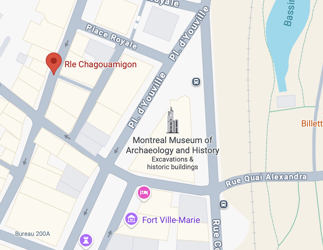
Google Map of Ruelle Chagouamigon and the Pointe-à-Callière Museum in Vieux-Montréal.

La ruelle Chagouamigon (Ebook)
Histoire de Montréal: édition 375e anniversaire de la fondation de Montréal by Yvon Codère, 2016.
Today Montreal is a huge metro area, but in its oldest part there is a tiny street, a block long and so narrow that it is restricted from cars and trucks. The street commemorates Montreal’s historic connections to Chequamegon Bay. And as a personal note, there are also traces there of my French ancestors who arrived almost 400 years ago, some of whom made the long paddle with many portages up the Ottawa and across the great lakes to Madeline Island. They were able to do so only because their friends and trading partners, the Algonkian peoples, showed them the way to survive on the journey, and provided them with food and canoes. I find it amazing that I live in the Chequamegon Bay area and share a surname with long ago Montreal ancestors who are connected to a tiny street there named for the area I call home.
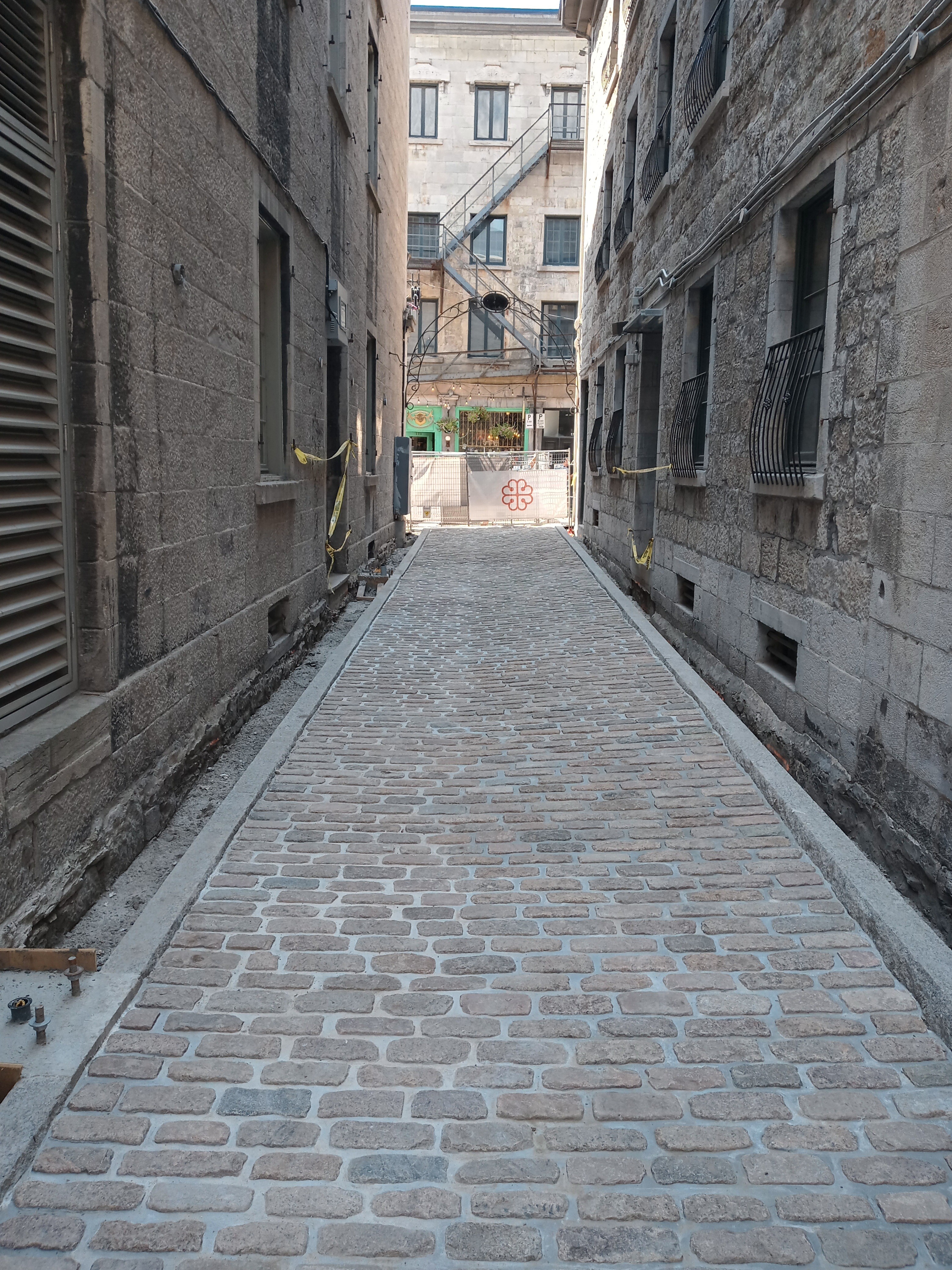
Ruelle Chagouamigon after being completely excavated for archaeological research and rebuilt. Photo taken by Francis Hervieux of the Pointe-à-Callière Museum in 2025.
—————
1 https://chequamegonhistory.com/about/.
2 Dollier de Casson, François (1636-1702) A History of Montreal 1640—1672 from the French of Dollier de Casson, translated and edited with a Life of the Author by Ralph Flenly, 1928. London & Toronto, J. M. Dent & sons, Ltd.; New York, E. P. Dutton & co. p. 103.
3 Miquelon, Dale. “Ville-Marie (Colony)“. The Canadian Encyclopedia. Archived from the original on December 3, 2013. Retrieved 22 October 2025.
4 Notary Antoine Adhémar, Library and Archives nationales du Québec (BANQ).
5 Claude Perrault “PERROT, NICOLAS”, in Dictionary of Canadian Biography, vol. 2, Laval University / University of Toronto, 2003.
6 Louise Trudeau “The History Page” Voyageur Sons Le Charpente December Volume 10 No 3, 2017.
7 Notary François Le Pallieur, Minute # 1022, Library and Archives nationales du Québec (BANQ).
8 Notary Louis-Claude Danré of Blanzy, BANQ.
9 Notary Louis-Claude Danré of Blanzy, BANQ.
Judge Bell Incidents: King No More
October 16, 2025
Collected & edited by Amorin Mello
This post is the second of a series featuring newspaper items about La Pointe’s infamous Judge John William Bell. Today we explore obituaries of Judge Bell that described his life at La Pointe. Future posts of this series will feature articles about the late Judge Bell written by his son-in-law George Francis Thomas née Gilbert Fayette Thomas a.k.a G.F.T.
… continued from King of the Apostle Islands.

Wisconsin State Journal
Saturday, December 31, 1887, Page 1
King of the Apostle Islands No More
ASHLAND, Wis., Dec. 31. – Judge Bell, known far and wide as “King of the Apostle Islands,” died yesterday. For nearly half a century he governed what was practically a little monarchy in the wilderness. He was 83 years old, and was the oldest living settler on the historic spot where Marquette founded his mission, two hundred years ago.
The Saint Paul Globe
Saturday, December 31, 1887, Page 1
KING OF THE ISLANDS.
Judge Bell,
“King of the Apostle Islands,”
Has Given Up His Crown.
The Oldest Living Pioneer
of the Historic Spot
Dies in Apparent Poverty,
Special to the Globe.

San Francisco Examiner
Wednesday, January 3, 1888, Page 2
ASHLAND, Wis., – “The king of the Apostle islands” is dead. He passed away at an early hour this morning at La Pointe, on Madeline, the largest of the group, where he has lived for forty-four years, the oldest living pioneer of the historic spot where Pere Marquette founded his little Indian mission 200 years ago. Judge Bell was a character in the early history of the Lake Superior region, known far and wide as the “king” of the country known as La Pointe, which was organized in 1846 by Judge Bell. The area of the country was as large as many states of the Union, its borders including nearly all of Wisconsin north of the Chippewa river, the Apostle islands and to an almost
ENDLESS DISTANCE WEST.

Wisconsin Historical Society’s copy of Lyman Warren’s 1834 “Map of La Pointe” from the American Fur Company Papers at New York Historical Society.
The population of whites consisted only of a small handful of French voyagers, traders and trappers, most of whom rendezvous at La Pointe. The country was hardly known by the state, and Bell’s county was practically a young monarchy. He bossed everything and everybody, but in such a way that every Indian and every white was his friend and follower. Judge Bell came here in 1832, from Canada, in the employ of the American Fur company, which at that time was a power here. He had rarely left the island, except in years gone by to make occasional pilgrimages through the settlements. During his eventful life he held every office in the county, and for many years, served as county judge. He was a man of great native ability, possessed of a courage that controlled the rough element which surrounded him in the early days when there was no law except his will. He was honest, fearless,
A NATURAL-BORN RULER
Fargo Daily Argus
Sunday, January 1, 1888, Page 1
of men, and through his efforts the poor and needy were cared for, and in no instance did he fail to befriend them. For this reason among those who survive him, and who lived in the good old pioneer days, all were his firm friends. His power departed only when the advance guard of civilization reached the great inland sea, through the medium of the iron horse, and opened a new era in the history of the new Wisconsin. For many years he has been old and feeble and has suffered for the comforts of life, having become a charge upon the town. He squandered thousands for the people and died poor but not friendless. He was eighty-three years of age.
The Ashland News
Wednesday, January 4, 1888, Page 7
ANOTHER PIONEER GONE
DEATH OF “SQUIRE” BELL, “THE KING OF LAPOINTE.”
Sketch of the Life of the Oldest Settler in the Lake Superior Region.
He comes to La Pointe With John Jacob Astor for the American Fur Co.
Judge John W. Bell died Friday morning at seven o’clock at his home at La Pointe, on Madeline Island, aged eighty-four years.
1847 PLSS survey map detailing the mouth of Iron River at what is now Silver City, Michigan along the east entrance to the Porcupine Mountains.
John W. Bell was born in New York City on May 3, 1803, and was consequently eighty-four years and seven months old. He learnt the trade of a cooper, and in this capacity in the year 1835, he came to the Lake superior country for the United States Fur company. He first settled at the mouth of Iron river, in Michigan, about twenty miles west of Ontonagon. Here, at that time, was one of the principal trading and fishing posts of the American Fur company, La Pointe being its headquarters. Remaining at Iron river for a few years, he came to La Pointe about 1840, where he continued to reside till the time of his death.

1845 United States map by John Dower, with the northernmost area of Wisconsin Territory that became La Pointe County.
At the time he came upon this lake its shores were an unbroken wilderness. At the Sault was a United States fort, but from the foot of Lake Superior to the Pacific ocean, no white settlement existed. The American and Northwest Fur companies were lords of this vast empire, and their trading posts and a few mission stations connected with them, held control. A small detachment of United States soldiers formed the distant outposts of Ft. Snelling. The state of Wisconsin had not been organized. No municipal government existed upon this lake. It was many years before Wisconsin was organized.
1845 United States map by J. Calvin Smith, with the original 1845 boundaries of La Pointe County added in red outline.
“beginning at the mouth of Muddy Island river [on the Mississippi River], thence running in a direct line to Yellow Lake, and from thence to Lake Courterille, so to intersect the eastern boundary line at that place, of the county of St Croix, thence to the nearest point on the west fork of Montreal river, thence down said river to Lake Superior.”
Finally the county of La Pointe was formed, embracing all Wisconsin bordering upon the lake and extending to town forty north. “Squire Bell,” as he was always called, became one of the county as well as town officers of the town and county of La Pointe, and for more than thirty years continued to hold office, being at different times chairman of supervisors, register of deeds, justice of the peace, clerk of the circuit court and county judge. This last office he held for many years.
He was a man of genial nature and robust frame. About four years ago, while in Ashland he fell and fractured his thigh, and was never able to walk again. His sufferings from this accident were great and his pleasant face was never seen again in Ashland. He enjoyed the esteem and friendship of his neighbors, so far as is known without exception. He was clear headed and of commanding appearance. His influence among the Indians and the French who for many years were the only inhabitants in the country was very great, and continued to the last. For years his dictum was the last resort for the settlement of the quarrels in this primitive community, and it seems to have been just and satisfactory. He was often called “The King of La Pointe,” and for years no one disputed his supremacy.

Edwin Ellis, M.D.
Dr. Edwin Ellis, of this city, said in speaking of the dead old pioneer:
“Thus one by one the early settlers are passing away, and ere long an entirely new generation will occupy the old haunts. He will rest upon the beautiful isle overlooking Chequamegon bay, where the landscape has been familiar to him for more than a generation. We a little longer linger on the shores of time, waiting the summons to cross the river. While we consign the body of an old friend to the earth we will in all heartfelt sorrow say: ‘Requiescat in Pace.'”
Superior Times
Saturday, January 7, 1888, Page 2
The Lake Superior Monarch
Judge Bell, the ‘king of the Apostle islands,’ who died the other day on Madeline Island at the age of eighty-three, was a conspicuous character in the early history of the Lake Superior region. He was the “king” of the county known as La Pointe, which was organized in 1846 by himself. The county was as large as many states of the Union, its borders including nearly all of Wisconsin north of the Chippewa river, the Apostle islands, and to an almost endless distance west. The white population consisted of a handful of French voyagers, traders and trappers, most of whom made their rendezvous at La Pointe. The country was hardly known by the state, and Bell’s realm was practically a little monarchy. He “bossed” everything and everybody, but in such a way that every Indian and every white was his friend and follower. Judge Bell rarely left the island except to make occasional pilgrimages through the settlements. During his eventful life he held every office in the county, and of late years had served as county judge. He was a man of great native ability, and was possessed of a courage that controlled the rough element that surrounded him in the early days when there was no law except his will. He was an honest, fearless, natural-born ruler of men. Through his efforts the poor and needy were cared for. His power departed only when the advanced guard of civilization reached the great inland sea. For many years he had been feeble, and of late had become a charge upon the town. He spent thousands upon the people.
To be continued in Fooled the Austrian Brothers…
Chequamegon History Event: Trails & Towns Before Washburn
March 31, 2025

Join Amorin Mello at the Bayfield Heritage Association for a fun afternoon exploring maps and stories about Ancient Trails and Ghost Towns before the City of Washburn was founded in 1883.
2pm Sunday April 27, 2025 at the Bayfield Heritage Association.
Sponsored by the Apostle Islands Historic Preservation Conservancy.
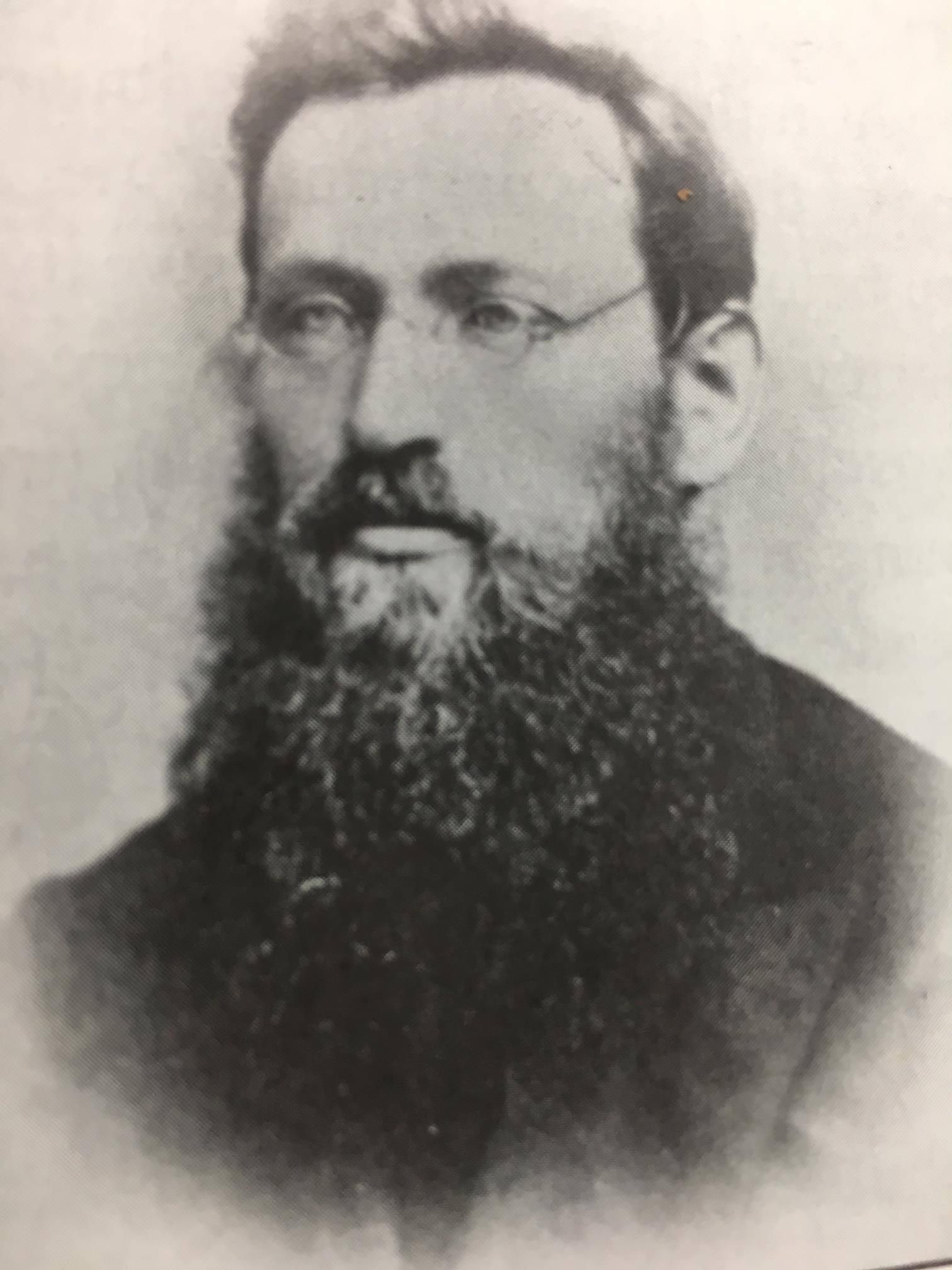
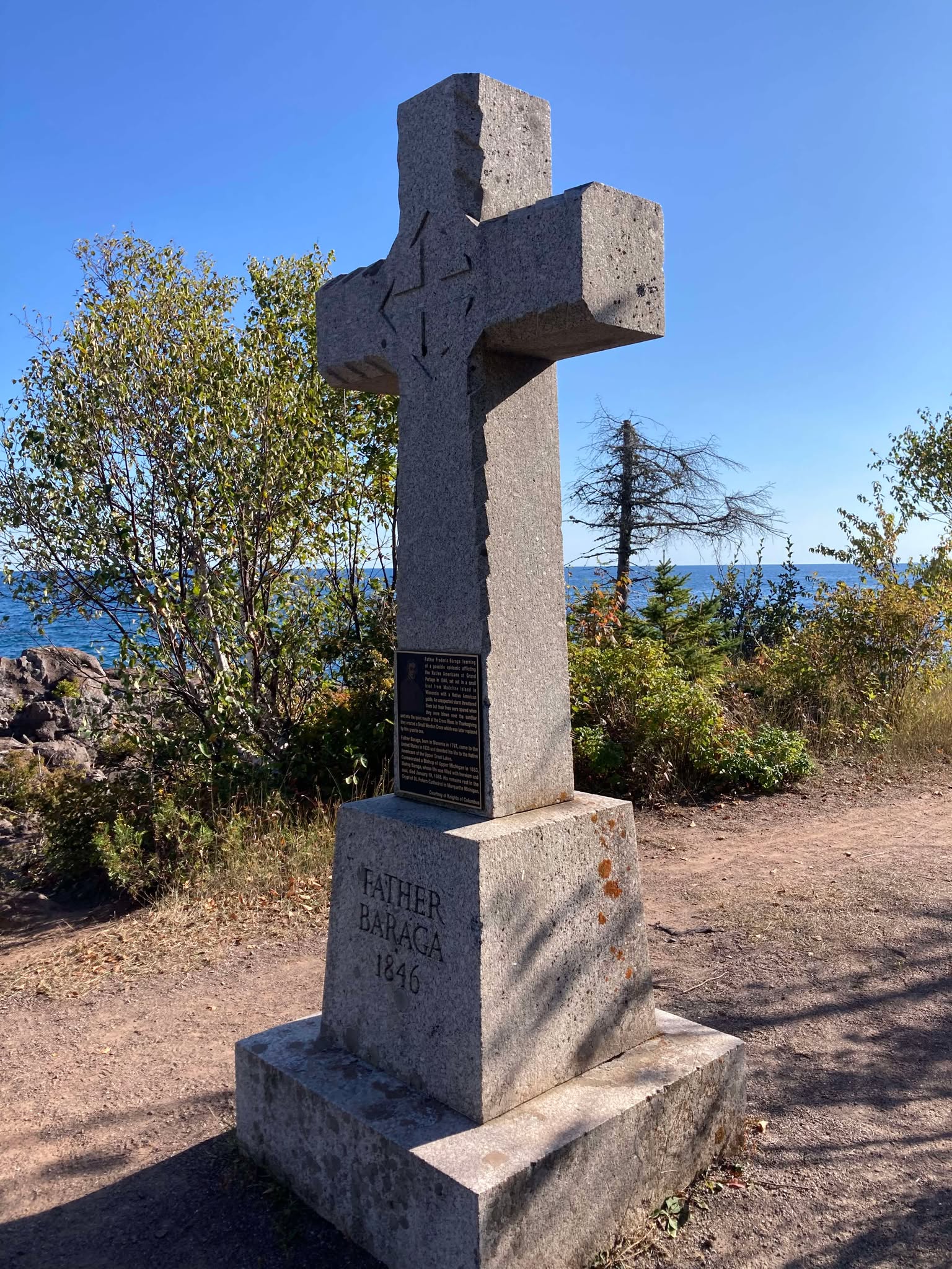
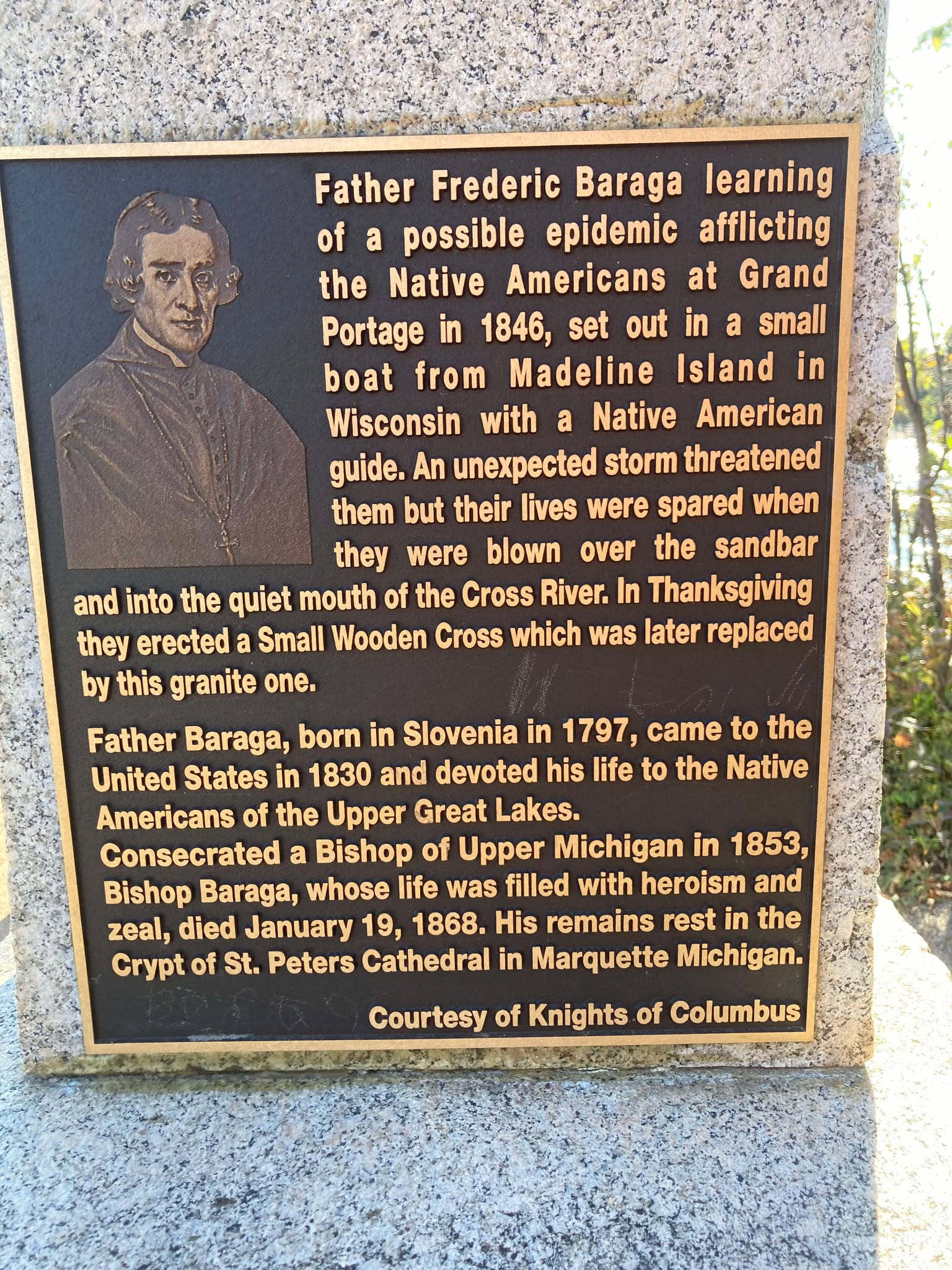
Bishop Baraga Crosses Lake Superior
February 18, 2025
Collected & edited by Amorin Mello

Bishop Irenaeus Frederic Baraga
~ Madeline Island Museum
This post features oral legends recorded about two of Bishop Irenaeus Frederick Baraga’s traverses from La Pointe across Lake Superior:
A) to Minnesota’s Cross River by canoe.
B) to Michigan’s Ontonagon River by ice.
In chronological order of publication, the first record was from a German traveloguer, the next two were from Catholic missionaries, and the last two were from Bad River tribal members.
- Kitchi-Gami, by Johann Georg Kohl, 1859/1860.
- Life and Labors of Bishop Baraga, by Rev. Chrysostom Verwyst, 1896.
- Life and Labors of Rt. Rev. Frederick Baraga, by Rev. Verwyst, 1900.
- Chippewa Indian Historical Project, by United States WPA, 1936-1942.
- Chippewa Indian Historical Project, by United States WPA, 1936-1942.

Originally published in German as
Kitschi-Gami; Oder, Erzählungen Vom Obern See
by Johann Georg Kohl, 1859.
Translated and republished in English as
Kitch-Gami: Wanderings Round Lake Superior,
By Johann Georg Kohl, 1860,
Pages 180-183.

German traveloguer
Johann Georg Kohl
Du Roy: “Do you known the summer voyage our most reverend friend, your companion, once made in a birch-bark canoe right across Lake Superior? Ah! that is a celebrated voyage, which everybody round the lake is acquainted with. Indeed, there is hardly a locality on the lake which is not connected with the history of his life, either because he built a chapel there, or wrote a pious book, or founded an Indian parish, or else underwent danger and adventures there, in which he felt that Heaven was protecting him.
“The aforesaid summer voyage, which I will tell you here as companion to his winter journey, was as follows:
“He was staying at that time on one of the Islands of the Apostles, and heard that his immediate presence was required at one of the little Indian missions or stations on the northern shore of the lake. As he is always ready to start at a moment, he walked with his breviary in his hand, dressed in his black robe, and with his gold cross fastened on his breast – he always travels in this solemn garb, on foot or on horseback, on show-shoes or in a canoe – he walked, I say, with his breviary in his hand and his three-corned hat on his head, into the hut of my cousin a well-known Voyageur, and said to him: ‘Dubois, I must cross the lake, direct from here to the northern shore. Hast thou a boat ready?’
” ‘My boat is here,’ said my cousin, ‘but how can I venture to go with you straight across the lake? It is seventy miles, and the weather does not look very promising. No one ever yet attempted this “traverse” in small boats. Our passage to the north shore is made along the coast, and we usually employ eight days in it.’
” ‘Dubois, that is too long; it cannot be. I repeat it to thee. I am called. I must go straight across the lake. Take thy paddle and “couverte,” and come!’ And our reverend friend took his seat in the canoe, and waited patiently till my obedient cousin (who, I grant, opened his eyes very wide, and shook his head at times) packed up his traps, sprang after him and pushed the canoe on the lake.
“Now you are aware, monsieur, that we Indians and Voyageurs rarely make greater traverses across the lake than fifteen miles from cape to cape, so that we may be easily able to pull our boats ashore in the annoying caprices of our weather and water. A passage of twenty-five or thirty miles we call a ‘grand traverse,’ and one of seventy miles is a impossibility. Such a traverse was never made before, and only performed this once. My cousin, however, worked away obediently and cheerfully, and they were soon floating in their nutshell in the middle of the lake like a loon, without compass and out of sight of land. Very soon, too, they had bad weather.
“It began to grow stormy, and the water rose in high waves. My cousin remarked that he had prophesied this, but his pious, earnest passenger read on in his breviary quietly, and only now and then addressed a kind word of encouragement to my cousin, saying that he had not doubted his prophecy about the weather, but he replied to it that he was called across the lake, and God would guide them both to land.
“They toiled all night through the storm and waves, and, as the wind was fortunately with them, they moved along very rapidly, although their little bark danced like a feather on the waters. The next morning they sighted the opposite shore. But how? With a threatening front. Long rows of dark rocks on either side, and at their base a white stripe, the dashing surf of the terribly excited waves. There was no opening in there, no haven, no salvation.
” ‘We are lost, your reverence,’ my cousin said, ‘for it is impossible for me to keep the canoe balanced in those double and triple breakers; and a return is equally impossible, owing to the wind blowing so stiffly against us.’
” ‘Paddle on, dear Dubois – straight on. We must get through, and a way will offer itself.’
“My cousin shrugged his shoulder, made his last prayers, and paddled straight on, he hardly knew how. Already they heard the surf dashing near them; they could no longer understand what they said to each other, owing to the deafening noise, and my cousin slipped his couverte from his shoulders, so as to be ready for a swim, when, all at once, a dark spot opened out in the white edge of the surf, which soon widened. At the same time the violent heaving of the canoe relaxed, it glided on more tranquilly, and entered in perfect safety the broad mouth of a stream, which they had not seen in the distance, owing to the rocks that concealed it.
” ‘Did I not say, Dubois, that I was called across, that I must go, and that thou wouldst be saved with me? Let us pray!’ So the man of God spoke to the Voyageur after they had stepped ashore, and drawn their canoe comfortably on the beach. They then went into the forest, cut down a couple of trees, and erected a cross on the spot where they landed, as a sign of their gratitude.
“Then they went on their way to perform their other duties. Later, however, a rich merchant, a fur trader, came along the same road, and hearing of this traverse, which had become celebrated, he set his men to work, and erected at his own expense, on the same spot, but on a higher rock, a larger and more substantial cross, which now can be seen a long distance on the lake, and which the people call ‘the Cross of —–‘s Traverse.’”

Historical Collections and Researches of Michigan Pioneer and Historical Society: Vol. XXVI,
by Michigan State Historical Society, 1896,
pages 541-542.
LIFE AND LABORS OF BISHOP BARAGA
A short sketch of the life and labors of Bishop Baraga
The Great Indian Apostle of the Northwest.
By Rev. Chrysostom Verwyst O.S.F. of Ashland, Wis.
Father John Chebul arrived on Lake Superior at the Sault in October 1859 to assist his fellow Slovanian Bishop Baraga. Chebul spent the winter at Ontonagon with miners before arriving at La Pointe in May 1860.
On another occasion Father Baraga went to Ontonagon from La Pointe. We will relate the incident as told to the writer by Rev. John Cebul, of Newberry, Mich. He was well acquainted with Bishop Baraga, being a fellow countryman who had been sent to La Pointe in 1860, where he labored amongst the Chippewas of that island and Bayfield, Bad River Reserve, Superior and other places, for about thirteen years, being universally loved and esteemed by all. He says:
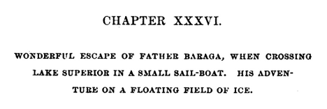
Bishop Baraga was intending to go on the ice to Ontonagon. He was accompanied by a man from the island. The reason they took to the ice was because it was much nearer and the walking a great deal better than on the main land. During March and April the ice on Lake Superior becomes honey-combed and rotten. If a strong wind blows, it cracks and moves from the shore if the wind blows from the land. Such fields of ice does not notice that he is in danger till he comes to the edge of the ice and then to his horror discovers a large expanse of open water between him and the mainland. Should the ice float out towards the middle of the lake or break up, he is lost. Father Baraga and his companion had traveled on the ice for some time, thinking all was right. All at once they came to the edge of the ice and saw it was impossible to reach land, as the wind had driven the ice from the shore out into the Lake. His companion became greatly alarmed. Father Baraga remained calm, praying, no doubt, fervently to Him who alone could save them. Finally the wind changed and drove the cake of ice on which they were floating to the shore. They landed at Cadotte point, about 20 or 30 miles from Ontonagon, having been carried by the wind on their ice raft about sixty miles. “See,” said the good priest to his companion, “we have traveled a great distance and yet have not labored.” It seems the good God wanted to save the saintly missionary a long and painful walk, by giving him a ride of sixty miles on a cake of ice.

Life and labors of Rt. Rev. Frederic Baraga
by P. Chrysostomus Verwyst, 1900,
pages 219-222.
“Louis Gaudin“ was one of several legendary children born to Jean Baptiste Gaudin, Sr. and Awenishen (a sister of Hole-in-the-day):
– Antoine Gordon
– Elizabeth (Gordon) Belanger
– Louison Gordon, Sr.
– Harriet (Gordon) Lemon
– John Baptiste Gordon, Jr.
– Angelique Gordon
– Joseph GordonLouison Gordon, Sr. (1814-1899) married Julia Brebant, whose sisters were married to Henry Bresette and Judge John W. Bell.Wizon is an objibwecized form of the francophone name Louison.
Undated photo from the Gordon Museum thought to be a brother of Antoine Gordon:
possibly Louis Gordon?

Chippewa Entrepreneur
Antoine Gordon
~ Noble Lives of a Noble Race (pg. 207) published by the St. Mary’s Industrial School in Odanah, 1909.
We learn from F. Baraga’s letter, written in October, 1845, that he intended to go to Grand Portage, Minn., the next fall to build a church there. It is, therefore, highly probable that he made that trip in the fall of 1846. He first went to La Pointe, where, no doubt, he spent some time attending to the spiritual wants of the good people. He then engaged a half-breed Indian, named Louis Gaudin, to go with him to Grand Portage. They had but a small fishing boat with a mast and sail, without keel or centre-board. Such a boat might do on a river or small lake, but would be very unsafe on a large lake, where it would easily founder or be driven lake a cork before the wind. The boat was but eighteen feet long. When they started from La Pointe, the people laughed at them for attempting to make the journey. They said it would take them a month to make the voyage, as they would have to keep close to the shore all the way, going first west some seventy miles to the end of the lake and then, doubling, turn northward, coasting along the northern shore of Lake Superior. this would make the distance about two hundred miles, perhaps even more.
However, Father Baraga and his guide set out on their perilous journey. At Sand Island they awaited a favorable wind to cross the lake, which is about forty miles wide at that place. By so doing they would save from eight to one hundred miles, but would expose themselves to great danger, as a high wind might arise, whilst they were out on the open lake, and engulf their frail bark.
They set sail on an unusually calm day. Father Baraga steered and Louis rowed the boat. Before they got midway a heavy west wind arose and the lake grew very rough. They were constantly driven leeward and when they finally reached the north shore they were at least thirty miles east of their intended landing place, having made a very perilous sail of seventy miles during that day.
While in the height of the storm, in mid-ocean, it might be said, Louis became frightened and exclaimed in Chippewa to the Father, who was lying on his back in the boat, reciting his office in an unconcerned manner: “Nosse, ki ga-nibomin, gananbatch” – Father, perhaps we are going to perish!” The Father answered quietly: “Kego segisiken, Wizon” (Chippewa for Louis) – “Don’t be afraid, Wizon; the priest will not die in the water. If he died here in the water the people on the other shore, whither we are going, would be unfortunate.”
When nearing the north shore the danger was even greater than out on the open water, for there were huge breakers ahead. Louis asked the Father whither to steer, and, as if following a certain inspiration, F. Baraga told him to steer straight ahead for the land. Through a special disposition of Divine Providence watching over the precious life of the saintly missionary, they passed through the breakers unharmed and ran their boat into the mouth of a small river, heretofore unnamed, but now called Cross River.
1859 PLSS detail of trees at the mouth of “Cross River”.
Full of gratitude for their miraculous escape, they at once proceeded to erect a cross. Hewing a tree in a rough manner, they cut off the top as far up as they could reach, and taking a shorter piece, they nailed it cross-wise to the tree. “Wizon,” said the Father, “let us make a cross here that the Christian Indians may know that the priest coming from La Pointe landed here.” The cross was, it is true, unartistic, but it was emblem of their holy faith and it gave the name, Tchibaiatigo-Sibi, “Cross River,” to the little stream where they landed.
They arrived none too soon. Ascending an eminence and looking out on the immense lake they saw that the storm was increasing every moment; high waves with white caps, which would surely have engulfed their little bark. They landed about six o’clock in the evening. Having spent the night there, they continued their journey next day, and in two days arrived at Grand Portage, having made the whole journey in three days. May we not think with Louis Gaudin that their safe passage across the stormy lake, and their deliverance from a watery grave, was due to a special intervention of Divine Providence in favor of the saintly missionary?

Missionary Labors of Fathers Marquette, Menard and Allouez, in the Lake Superior Region by Rev. Chrysostom Verwyst of Bayfield, 1886.
In 1667 Father Claude Allouez, S. J., then stationed at the mission of the Holy Ghost at the head of Chequamegon Bay, made the voyage across the lake from Sand Island. He made the voyage in a birch-canoe with three Indians. He remarks that they paddled their canoe all day as hard as they could without intermission, for fear of losing any of the beautiful calm weather they had. It took them twelve hours to make the trip across. The Father was then on his way to visit some Christian Indians residing at Lake Nipigon – “Animibigong” in Chippewa. For the particulars of this journey we refer the reader to “Missionary Labors of Fathers Marquette, Allouez, and Menard in the Lake Superior Region.”
The following narrative is not to be found in any of Baraga’s published letters, but the writers has it from the mouth of trustworthy persons, among whom is Father Chebul, a countryman of F. Baraga, who was stationed at Bayfield for many years. We will give the account, as we have it from Rev. F. Chebul.
Francois Newago, Sr. is the “man named Newagon” from Madeline Island, as his children were still young teenagers then.One time F. Baraga was going to Ontonagon in company with an Indian half-breed in the month of March or April. At that season of the year the ice, though thick, becomes honey-combed and rotten. Some say that Baraga’s companion was a man named Newagon. They went on the ice at La Pointe Island. As the walking on the sandy beach would have been very fatiguing and long, they determined to make straight for Ontonagon over the ice. By so doing they would not only have better walking, but also shorten their way a great deal.
A strong southwest wind was blowing at the time, and the ice, becoming detached from the shore, began drifting lakeward. After they had traveled for some time, they became aware of what hat happened, for they could see the blue waters between them and the shore. Newagon became greatly alarmed, for almost certain death stared them in the face. Had the wind continued blowing in the same direction, the ice would have been driven far out into the lake and broken up into small fragments. They would surely have perished.
To encourage the drooping spirit of his companion, F. Baraga kept telling him that they would escape all right and that they must trust in God, their loving Father and Protector. He also sang Chippewa hymns to divert Newagon’s attention and calm his excitement. Finally the wind shifted and blew the field of ice back towards the shore.
1847 PLSS detail of brownstone points, village, cross, and trailhead at the mouth of Iron River.
“Cadotte Point, near Union Bay“
appears to be located at what is now Silver City at the mouth of Iron River and eastern trailhead to the Porcupine Mountains.Michel Cadotte, Sr. ran a trading post by the Old French Fort on Madeline Island around 1800 and smaller stations scattered along the Wisconsin / Michigan shoreline of Lake Superior. Cadotte first worked for the British North West Company and later the American Fur Company after The War of 1812.They landed near Cadotte Point, near Union Bay, a short distance from Ontonagon, which they reached that same day. “See,” said the missionary to his companion, “we have traveled a great distance and have worked little.” The distance from La Pointe to Ontonagon is about sixty or seventy miles by an air line. Had they been obliged to walk the whole distance around the bend of the lake, it would probably have taken them two or three days of very hard and fatiguing traveling. So what at first seemed to threaten certain death was used by God’s fatherly providence to shorten and facilitate the saintly priest’s journey.
United States. Works Progress Administration:
Chippewa Indian Historical Project Records 1936-1942
(Northland Micro 5; Micro 532)
Reel 1, Envelop 3, Item 5
BISHOP BARAGA’S TRIP TO ONTONAGON
As related by William Obern to John Teeple.
Francois Belanger, Sr.
and Elizabeth (Gordon) Belanger. The Belanger Settlement was founded by their son Frank Belanger, Jr. and Elizabeth (Morrow) Belanger.
The journey I am about to describe is taken from the many experiences of Bishop Baraga, which were related to me by my grandfather. It deals with a journey made at an almost impossible time for ice travel on any of the Great Lakes, and portrays the important part the elements can play in a man’s life, for good or bad, for weal or for woe, as well as Bishop Baraga’s unfaltering confidence in Divine Providence.
The season of the year in which this incident took place was in the spring – along in April. Bishop Baraga and his faithful guide, Louis Gordon, started from LaPointe enroute to Ontonagon, Michigan, a distance of some eighty or ninety miles from LaPointe, straight across as the crow flies over the frozen water of Lake Superior. Dogs were used to a very large extent in those days for the purpose of transportation.
On account of the prevailing soft weather, the ice on the lake was not very solid, and with the right kind of wind, a general break-up was apt to occur at any time. In this instance, when the Bishop and his guide were about ten miles from LaPointe a south-west wind began to blow, increasing in velocity with each passing hour. The ice broke away from the shore, and began drifting outward into the open waters of Lake Superior, carrying its passengers with it. The guide, seeing the danger, suggested to the Bishop that they land on one of the islands, but the Bishop told him not to worry and to keep going in the direction of Ontonagon; that with the help of God they would reach their destination in safety.
With the coming of night the wind increased, and the two travelers were drifting out into the open waters with considerable speed. Soon the mainland was lost to view, and the guide knew that to remain on the ice mean ultimate death by freezing or drowning, but it was too late to do anything now. They had passed up the opportunity of getting off.
The missionary told Louis to look out for the dogs, and after taking a lunch, he wrapped himself up and went to sleep. He advised the guide to do likewise. The guide wrapped himself up, but he did not sleep. He kept constant vigil; about midnight the wind changed, coming from the opposite direction.

Detail of Porcupine Mountains, Iron River and Ontonagon River on the Map of the Mineral Lands Upon Lake Superior Ceded to the United States by the Treaty of 1842 With the Chippeway Indians, 1845.
The guide woke Bishop Baraga, telling him that the wind had changed. The priest asked his guide from what direction it was blowing, and upon being told that it was coming from the north-east remarked, “It is just what I hoped for and suspected.” He again told his guide to lie down and go to sleep, but the guide fearing that the plate of ice they were on might break up, would not sleep. They began to drift back almost in the same direction they had come, and when daylight came the outline of the Porcupine Mountains could be plainly seen in the distance. They were traveling at a very high rate of speed, and about mid afternoon they landed on the south shore of Lake Superior, one mile from Ontonagon, their destination.
“There,” said the bishop after they got off the ice and stepped on to the mainland, “this is just what I expected.”
At the time of this narrative, Ontonagon was a small settlement of Indians with but a few white men, who were engaged in the fur trade with the Indians and represented the American Fur Company.
* According to the description furnished by the guide, the piece of ice they were on was about one hundred by two hundred feet.
United States. Works Progress Administration:
Chippewa Indian Historical Project Records 1936-1942
(Northland Micro 5; Micro 532)
Reel 1, Envelop 3, Item 6
Cross River
ORIGIN OF THE NAME
Related by William Obern
To John Teeple.
Ojibwe, Activist, Priest
The Life of Father Philip Bergin Gordon, Tibishkogijik
by Tadeusz Lewandowski, 2019.
The story I am about to relate deals with an incident of one of the many experiences of Bishop Baraga. The narrative was related to me by my grandmother, Elizabeth Bellanger, who before her marriage was Elizabeth Gordon. She was a blood relative of Father Philip Gordon. The Gordon family consisted of the parents; sons, John, Louis and Antoine, and daughters My grandmother (Elizabeth) and Angelique.
Louis Gordon acted as the guide and all-around servant of Bishop Baraga, the missionary priest. The latter had a very large territory to cover; the northern and southern shores of Lake Superior, thence to the Dakotas and down to the waters known as Chippewa River, which emptied into the Mississippi below St. Paul.
Louis Gordon, the guide, (my grand-uncle) told of many of the experiences he had on these trips with Bishop Baraga. In speaking of my grand-uncle, Louis Gordon, I wish to state first, upon my honor as a gentleman, that he was a Christian in every sense of the word; he never took a drink of intoxicating liquor in his life; and never used profane language.
The stories related to me by my grandmother I well remember, and coming from a man like my grand-uncle, I believe them.
One day Bishop Baraga and his guide, Louis Gordon, started from LaPointe, on the western end of Lake Superior, near the place now known as Bayfield, on the shore of the lake, and about twenty-five miles from the present city of Ashland. At the time of this incident there were no white settlements to speak of at the western end of Lake Superior and the “head of the lakes” region. Bayfield, Washburn, Ashland, Superior and Duluth did not exist in those days. There were few white men among the Indians, and those few represented the American Fur Company. A few, mostly Frenchmen, had in former years settled in Minnesota and Wisconsin.
As formerly stated the trip started from LaPointe. It was to be made by water, and the boat used by the missionary and his guide, from the description given, could not have been more than 16 or 18 feet long. It was just large enough to accommodate the Bishop and his guide and to take care of their camping equipment, and although small, it came out the victor in many storms, proving itself quite seaworthy. These voyagers had a make-shift sail, which furnished them power when the wind was fair, probably a blanket which was raised on a pole; but in calm weather, or when the seas became too rough, the craft was usually propelled with oars. Wind and weather conditions in those days controlled lake travel largely, and when the lake became too rough and the seas too choppy, the voyageurs usually made a landing in some bay or stream outlet.
In this instance, the missionary and his guide were headed for Grand Marias, on the north shore of Lake Superior, a distance of fifty or fifty-five miles from the group of islands known as “Apostle Islands.” Leaving LaPointe, it was necessary for them to cross Lake Superior, traveling directly North. In the event of a severe storm, there is, of course, no place for shelter in the open waters of Lake Superior, and when once started it was necessary for them to continue their voyage until they reached Grand Marias, the point of their destination.
When the Bishop and his guide were about to leave the Apostle Islands, Louis Gordon, the guide, said to Bishop Baraga: “No-say,” (meaning father in Chippewa), “it would not be safe for us to cross the lake in this small boat today. The wind is from the south-west, and it is getting stronger. The lake will become very rough, the seas high, and I am afraid we may perish if we venture out in this wind. We had better not leave this island today, or else follow the south shore around to the end of the lake, so we can find a place to land should the seas become too rough.”
Bishop Baraga replied, “My son, have faith in God. Across that lake my Indians are waiting they must be expecting me, and it is my duty to get there as soon as possible. It would be a waste of time for us to go along the south shore, then along the north shore from the St. Louis River to Grand Marias, when we can cross here and save many miles of hard rowing and precious time. We will trust in God and make the crossing in safety.”
So, Louis Gordon, having unbounded faith in the Bishop, obeyed him, and they began their voyage across the lake, notwithstanding the fact that the wind was increasing in fury and the seas becoming higher and rougher with each passing moment. After they got into the open waters, the guide had considerable difficulty in manning the boat and keeping it from being swamped by the breaking seas. He stood up, and turning to Bishop Baraga said, “No-say, we will never reach the shore.” The Bishop was sitting at the stern of the boat, reciting his breviary. “Louis,” he said, “do not lose faith in God; fear not, He is with us.” The guide was kept busy in keeping the boat in its course, and bailing it out, to prevent it from being filled as the white caps would break over it. He headed it to a point west of Grand Marias in order that he might be better able to ride the crest of the seas, praying and hoping that when they reached the shore, which he hoped would be before dark, they would find a place to land in safety.
I wish to state here that I have seen the north shore of Lake Superior. After leaving Duluth, going east along the north shore, one will find a very rugged shore, ledges of rock from 20 to 200 feet in height standing perpendicularly along the shore line. In these rock ledges are great caves that have been fashioned by angry waves of Lake Superior during centuries. To fully appreciate this story it is well for the reader to know a little concerning the dangers of Lake Superior. Salt-water sailors who have been on the five oceans prefer to be on the ocean in a storm rather than on Lake Superior. The fact that Lake Superior is more dangerous than the oceans is conceded by sailors generally, particularly in the fall of the year. In the ocean, the billows are longer with great spaces between them; while on Lake Superior they are short, choppy, and heavy; and create much more hazard.
Night overtook the missionary and the guide before they reached the north shore; the wind became stronger and the billows higher. The only light they had to guide them was the distant glimmer of the stars, and the guide was able to keep his course by keeping his craft nosed in the direction of the North Star.
After many hours of hard pulling on the oars, the guide knew that they were reaching the shore because he was familiar with the shoreline, and knew that the noise which was all but deafening was created by the breakers dashing against the rock-bound shore.
The guide said to his companion, “No-say, we are nearing the shore, but I am sure we are many miles from Grand Marias. There is no river known in this region and on account of the precipitous formation of the shore line, we have no place to land in safety in this storm.” Bishop Baraga answered, “My son, do as I say, and we will make a landing in safety.” The guide obeyed. His hand were blistered; his strength was leaving his body, but he managed to keep up his struggle against the angry seas. The back-wash created by the billows dashing against the perpendicular rocks of the shore-line made conditions more perilous. The guide said, “Father, there is nothing but certain death ahead of us. We cannot survive this storm.” The noise was so great that it was impossible for the two voyagers to hear each other without shouting, though they were only fifteen or sixteen feet apart; but the Bishop simply said, “Louis, keep going straight ahead.”
Much water had entered their little boat, and it was coming in faster now that they were nearing the ledges of rocks, and the seas, augmented by the back-wash, were becoming rougher, so that destruction seemed imminent. Then amid the tumult and tossing of the boat upon the choppy seas, the boat was suddenly driven from the rough sea into tranquil waters, seemingly guided by some supernatural power. The guide knew that the craft was not being directed by his efforts, and that they were nearing the shore with each sweep of the waves. To his amazement, the boat grounded, and by feeling the depth of the water with his oar he knew that they were in shallow water, but he was unable to determine whether they were in a cave or at the mouth of some stream.
“Father,” Louis cried delightedly, “it seems to me that we are in a cave or at the mouth of some stream, because by feeling around with my oar I can feel a current coming from the land direction.” The missionary then told him to take out their bundle, and light the lantern so that they could see where they were and explore their surroundings.
After lighting the lantern, they made a survey of their surroundings and found that they were at the mouth of a large stream. They climbed out of the river and to higher ground, and there made their camp for the night.
Cross River Historical Marker
Photo by Brian Finstad, 2024.
The following morning, Bishop Baraga told his guide that they would stay there that day, that they would construct and erect a cross in token of thanksgiving to God for his help and guidance to safety. So, all that day they worked. They cut down some large cedar trees and erected a large cedar cross, which they set up on the shore at the mouth of the stream. The next morning Bishop Baraga and his guide went down to the site of the cross they had erected, and again offered thanks to God for their safe deliverance. The missionary told his guide: “Hereafter this stream shall be known as “Cross River”. It has been thus known from that time on.
About twenty or twenty-five years ago, a large number of people from Duluth, Superior, and other towns and cities in the Lake Superior region, regardless of creed, made a trip to Cross River and erected a substantial cross there in place of the old cedar cross set up by Bishop Baraga and his guide, Louis Gordon, in thanksgiving to God for the wonderful guidance and loving care of his servants who landed safely at the mouth of this stream after such a perilous voyage.
Bishop Baraga stopped at Superior on their way back from the North Shore. They did not venture another lake-crossing. This zealous Lake Superior Chippewa Indian Missionary died at Marquette, Michigan, on January 19, 1868.
Cross River Historical Marker
Photo by Brian Finstad, 2024.
Judge Bell Incidents: King of the Apostle Islands
January 30, 2025
Collected & edited by Amorin Mello
This post is the first of a series featuring The Ashland News items about La Pointe’s infamous Judge John William Bell, written mainly by his son-in-law George Francis Thomas née Gilbert Fayette Thomas a.k.a G.F.T.
Wednesday, September 30, 1885, page 2.
ON HISTORICAL GROUND.

James Chapman
~ Madeline Island Museum

Judge Joseph McCloud
~ Madeline Island Museum
Saturday last, says The Bayfield Press, the editor had the pleasure of visiting Judge John W. Bell at his home at La Pointe, accompanied by Major Wing, James Chapman and Judge Joseph McCloud. The judge, now in his 81st year, still retains much of that indomitable energy that made him for many years a veritable king of the Apostle Islands. Owing, however, to a fractured limb and an irritating ulcer on his foot he is mostly confined to his chair. His recollection of the early history of this country is vivid, while his fund of anecdotes of his early associates is apparently inexhaustible and renders a visit to this remarkable pioneer at once full of pleasure and instruction. The part played by Judge Bell in the early history of this country is one well worthy of preservation and in the hands of competent parties could be made not the least among the many historical sketches of the pioneers of the great northwest. The judge’s present home is a large, roomy house, located in the center of a handsome meadow whose sloping banks are kissed by the waters of the lake he loves so well. Here, surrounded by children and grand-children, cut off from the noise and bustle of the outside world, his sands of life are peacefully passing away.
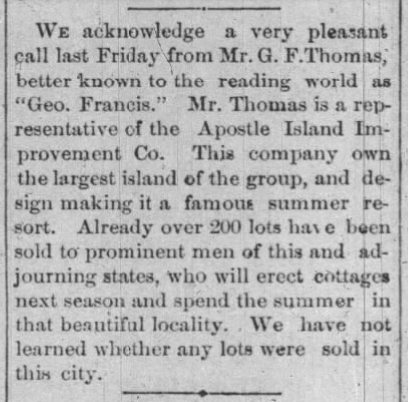
Leaving La Pointe our little party next visited the site of the Apostle Islands Improvement company’s new summer resort and found it all the most vivid fancy could have painted. Here, also, we met Peter Robedeaux, the oldest surviving voyager of the Hudson Bay Fur Co. Mr. Robedeaux is now in his 89th year, and is as spry as any man not yet turned fifty. He was born near Montreal in 1796, and when only fourteen years of age entered the employ of the Hudson Bay Fur Co., and visited the then far distant waters of the Columbia river, in Washington Territory. He remained in the employ of this company for twenty-five years and then entered the employ of the American Fur company, with headquarters at La Pointe. For fifty years this man has resided on Madeline Island, and the streams tributary to the great lake not visited by him can be numbered by the fingers on one’s hand. His life until the past few years has been one crowded with exciting incidents, many of which would furnish ample material for the ground-work of a novel after the Leather Stocking series style.
Wednesday, June 30, 1886, page 2.
GOLDEN WEDDING.
About thirty of the old settlers of Ashland and Bayfield went over to La Pointe on Saturday to celebrate the golden wedding anniversary of Judge John W. Bell and wife, who were married in the old church at La Pointe June 26th, 1836, fifty years ago. The party took baskets containing their lunch with them, the old couple having no knowledge of the intended visit. After congratulations had been extended the table was spread, and during the meal many reminiscences of olden times were called up.
Judge Bell is in his eighty-third year, and is becoming quite feeble. Mrs. Bell is perhaps ten or twelve years younger. Judge Bell came to La Pointe in 1834, and has lived there constantly ever since. La Pointe used to be the county seat of Ashland county, and prior to the year 1872 Judge Bell performed the duties of every office of the county. In fact he was virtually king of the island.
The visitors took with them some small golden tokens of regard for the aged couple, the coins left with them aggregating between $75 and $100.
Wednesday, July 20, 1887, page 6.
REMINISCENCES OF OLD LA POINTE
(Written for The Ashland News)

Visitors to this quiet and delapidated old town on Madeline Island, Lake Superior, about whom early history and traditions so much has been published, are usually surprised when told that less than forty years have passed since there flourished at this point a city of about 2,500 people. Now not more than thirty families live upon the entire island. Thirty-five years ago neither Bayfield, Ashland nor Washburn was thought of, and La Pointe was the metropolis of Northern Wisconsin.
Since interesting himself in the island the writer has often been asked: Why, if there were so many inhabitants there as late as forty years ago, are there so few now? In reply a great number of reasons present themselves, chief among which are natural circumstances, but in the writer’s mind the imperfect land titles clouding old La Pointe for the last thirty years have tended materially to hastening its downfall.

Captain John Daniel Angus
~ Madeline Island Museum
Of the historic data of La Pointe, of which the writer has almost an unlimited supply, much that seems romance is actual fact, and the witnesses of occurrences running back over fifty years are still here upon the island and can be depended upon for the truthfulness of their reminiscences. There are no less than five very old men yet living here who have made their homes upon the island for over fifty years. Judge John W. Bell, or “Squire,” as he is familiarly called, has lived here since the year 1835, coming from the “Soo,” on the brig, John Jacob Astor, in company with another old pioneer of the place known as Capt. John Angus. Mr. Bell contracted with the American Fur Co., and Capt. Angus sailed the “Big Sea” over. Mr. Bell is now eighty three years of age, and is crippled from the effects of a fall received while attending court in Ashland, in Jan. 1884. He is a man of iron constitution and might have lived – and may yet for all we know – to become a centenarian. The hardships of pioneer life endured by the old Judge would have killed an ordinary man long ago. He is a cripple and an invalid, but he has never missed a meal of victuals nor does he show any sign of weakening of his wonderful mind. He delights to relate reminiscences of early days, and will talk for hours to those who prove congenial. Once in his career, Mr. Bell had in his employ the famous “Wilson, the Hermit,” whose romantic history is one of the interesting features sought after by tourists when they visit the islands.
~ History of Northern Wisconsin, by the Western Historical Co., 1881.
Once Mr. Bell started an opposition fur company having for his field of operations that portion of Northern Wisconsin and Michigan now included within the limits of the great Gogebic and Penokee iron ranges, and had in his employ several hundred trappers and carriers. Later Mr. Bell became a prominent explorer, joining numerous parties in the search for gold, silver and copper; iron being considered too inferior a metal for the attention of the popular mind in those days.
Almost with his advent on the island Mr. Bell became a leader in the local political field, during his residence of fifty-two years holding almost continually some one of the various offices within the gift the people. He was also employed at various times by the United States government in connection with Indian affairs, he having a great influence with the natives.

Ramsay Crooks
~ Madeline Island Museum
The American Fur Co., with Ramsay Crooks at its head gave life and sustenance to La Pointe a half century ago, and for several years later, but when a private association composed of Borup, Oakes and others purchased the rights and effects of the American Fur Co., trade at La Pointe began to fall away. The halcyon days were over. The wild animals were getting scarce, and the great west was inducing people to stray. The new fur company eventually moved to St. Paul, where even now their descendants can be found.

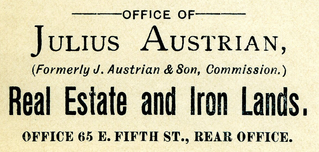
Julius Austrian
~ Madeline Island Museum
Prior to the final extinction of the fur trade at La Pointe and in the early days of steamboating on the great lakes, the members of the well-known firm of Leopold & Austrian settled here, and soon gathered about them a number of their relatives, forming quite a Jewish colony. They all became more or less interested in real estate, Julius and Joseph Austrian entering from the government at $1.25 per acre all the lands upon which the village was situated, some 500 acres.

Joseph Austrian
~ Jennifer Barber Family
The original patent issued by the government, of which a copy exists in the office of the register of deeds in Ashland, is a literary curiosity, as are also many other title papers issued in early days. Indeed if any one will examine the records and make a correct abstract or title history of old La Pointe, the writer will make such person a present of one of the finest corner lots on the island. Such a thing can not be done simply from the records. A large portion of the original deeds for village lots were simply worthless, but the people in those days never examined into the details, taking every man to be honest, hence errors and wrongs were not found out.
Now the lots are not worth the taxes and interest against them, and the original purchaser will never care whether his title was good or otherwise. The county of Ashland bought almost the whole town site for taxes many years ago and has had an expensive load to carry until the writer at last purchased the tax titles of the village, which includes many of the old buildings. The writer has now shouldered the load, and proposes to preserve the old relics that tourists may continue to visit the island and see a town of “Ye olden times.”
~ The Boscobel Dial
September 29, 1885.
Originally the intention was to form a syndicate to purchase the old town. An association of prominent citizens of Ashland and Bayfield, at one time came very near securing it, and the writer still has hopes of such an association some day controlling the historical spot. The scheme, however, has met with considerable opposition from a few who desire no changes to be made in the administration of affairs on the island. The principal opponent is Julius Austrian, of St. Paul, who still owns one-sixth part of La Pointe, and is expecting to get back another portion of lots, which have been sold for taxes and deeded by the county ever since 1874. He would like no doubt, to make Ashland county stand the taxes on the score of illegality. As a mark of affection for the place, he has lately removed the old warehouse which has stood so many years a prominent landmark in La Pointe’s most beautiful harbor. Tourists from every part of the world who have visited the old town will join in regretting the loss and despise the action.
G. F. T.
To be continued in King No More…
Chief Buffalo Picture Search: Coda
June 1, 2024
My last post ended up containing several musings on the nature of primary-source research and how to acknowledge mistakes and deal with uncertainty in the historical record. This was in anticipation of having to write this post. It’s a post I’ve been putting off for years.
Amorin forced the issue with his important work on the speeches at the 1842 Treaty negotiations. While working on it, he sent me a message that read something like, “Hey, the article quotes Chief Buffalo and describes him in a blue military coat with epaulets. Is the world ready for that picture that Smithsonian guy sent us years ago?”
This was the image in question:

Henry Inman, Big Buffalo (Chippewa), 1832-1833, oil on canvas, frame: 39 in. × 34 in. × 2 1/4 in. (99.1 × 86.4 × 5.7 cm), Smithsonian American Art Museum, Gift of Gerald and Kathleen Peters, 2019.12.2
We first learned of this image from a Chequamegon History comment by Patrick Jackson of the Smithsonian asking what we knew about the image and whether or not it was Chief Buffalo from La Pointe.
We had never seen it before.
This was our correspondence with Mr. Jackson at the time:
July 17, 2019
Hello, my name is Patrick, and I am an intern at the Smithsonian American Art Museum. I’m working on researching a recent acquisition: a painting which came to us identified as a Henry Inman portrait of “Big Buffalo Ke-Che-Wais-Ke, The Great Renewer (1759-1855) (Chippewa).” We have run into some confusion about the identification of the portrait, as it came to us identified as stated above, yet at Harvard Peabody Museum, who was previously the owner of the portrait, it was listed as an unidentified sitter. Seeing as you’ve written a few posts about the identification of images of the three different Chief Buffalos, I thought you might be able to give some insight into perhaps who is or isn’t in the portrait we have. Thank you for your time.
July 17, 2019
Hello,
I would be happy to comment. Can you send a photo to this email?
I am pretty sure Inman painted a copy of Charles Bird King’s portrait of Pee-che-kir.
Doe it resemble that portrait? Pee-che-kir (Bizhiki) means Buffalo in Ojibwe (Chippewa). From my research, I am fairly certain that King’s portrait is not of Kechewaiske, but of another chief named Buffalo who lived in the same era.
Leon Filipczak
July 17, 2019
Dear Leon,
I have attached our portrait—it’s not the best scan, but hopefully there’s enough detail for you to work with. I’ve compared it with the Peechikir in McKenney & Hall, as well as to the Chief Buffalo painted ambrotype and the James Otto Lewis portrait of Pe-schick-ee. The ambrotype has a close resemblance, as does the Peecheckir, though if that is what Charles Bird King painted I have doubts that Inman would make such drastic changes in clothing and pose.
The identification as Big Buffalo/Ke-Che-Wais-Ke/The Great Renewer, as far as I understand, refers to the La Pointe Bizhiki/Buffalo rather than the St. Croix or Leech Lake Buffalos, though of course that is a questionable identification considering Kechewaiske did not (I think) visit Washington until after Inman’s death in January of 1846. McKenney, however, did visit the Ojibwe/Chippewa for the negotiations for the Treaty of Fond du Lac in 1825/1826, and could feasibly have met multiple Chief Buffalos. Perhaps a local artist there would be responsible for the original? Another possibility is, since the identification was not made at the Peabody, who had the portrait since the 1880s, is that it has been misidentified entirely and is unrelated to any of the Ojibwe/Chippewa chiefs. Though this, to me, would seem unlikely considering the strong resemblance of the figure in our portrait to the Peechikir portrait and Chief Buffalo ambrotype.
Thank you again for the help.
Sincerely,
Patrick
July 22, 2019
Hello Patrick,
This is a head-scratcher. Your analysis is largely what I would come up with. My first thought when I saw it was, “Who identified it as someone named Buffalo? When? and using what evidence?” Whoever associated the image with the text “Ke-Che-Wais-Ke, The Great Renewer (1759-1855)” did so decades after the painting could be assumed to be created. However, if the tag “Big Buffalo” can be attached to this image in the era it was created, then we may be onto something. This is what I know:
1) During his time as Superintendent of Indian Affairs (late 1820s), Thomas McKenney amassed a large collection of portraits of Indian chiefs for what he called the “Indian Gallery” in the War Department. He sought the portraits out wherever and whenever he could. When chiefs would come to Washington, he would have Charles Bird King do the work, but he also received portraits from the interior via artists like James Otto Lewis.
2) In 1824, Bizhiki (Buffalo) from the St. Croix River (not Great Buffalo from La Pointe), visited Washington and was painted by King. This painting is presumed to have been destroyed in the Smithsonian fire that took out most of the Indian Gallery.
3) In 1825 at Prairie du Chien and in 1826 at Fond du Lac (where McKenney was present) James Otto Lewis painted several Ojibwe chiefs, and these paintings also ended up in the Indian Gallery. Both chief Buffalos were present at these treaties.
4) A team of artists copied each others’ work from these originals. King, for example remade several of Lewis’ portraits to make the faces less grotesque. Inman copied several Indian Gallery portraits (mostly King’s) to be sent to other institutions. These are the ones that survived the Smithsonian fire.
5) In the late 1830s, 10+ years after most of the portraits were painted, Lewis and McKenney sold competing lithograph collections to the American public. McKenney’s images were taken from the Indian Gallery. Lewis’ were from his works (some of which were in the Indian Gallery, often redone by King). While the images were printed with descriptions, the accuracy of the descriptions leaves something to be desired. A chief named Bizhiki appears in both Lewis and McKenney-Hall. In both, the chiefs are dressed in white and faced looking left, but their faces look nothing alike. One is very “Lewis-grotesque.” and the other is not at all. There are Lewis-based lithographs in both competing works, and they are usually easy to spot.
6) Not every image from the Indian Gallery made it into the published lithographic collections. Brian Finstad, a historian of the upper-St. Croix country, has shown me an image of Gaa-bimabi (Kappamappa, Gobamobi), a close friend/relative of the La Pointe Chief Buffalo, and upstream neighbor of the St. Croix Buffalo. This image is held by Harvard and strongly resembles the one you sent me in style. I suspect it is an Inman, based on a Lewis (possibly with a burned-up King copy somewhere in between).
7) “Big Buffalo” would seemingly indicate Buffalo from La Pointe. The word gichi is frequently translated as both “great” and “big” (i.e. big in size or big in power). Buffalo from La Pointe was both. However, the man in the painting you sent is considerably skinnier and younger-looking than I would expect him to appear c.1826.
My sense is that unless accompanying documentation can be found, there is no way to 100% ID these pictures. I am also starting to worry that McKenney and the Indian Gallery artists, themselves began to confuse the two chief Buffalos, and that the three originals (two showing St. Croix Buffalo, and one La Pointe Buffalo) burned. Therefore, what we are left with are copies that at best we are unable to positively identify, and at worst are actually composites of elements of portraits of two different men. The fact that King’s head study of Pee-chi-kir is out there makes me wonder if he put the face from his original (1824 portrait of St. Croix Buffalo?) onto the clothing from Lewis’ portrait of Pe-shick-ee when it was prepared for the lithograph publication.
A few weeks later, Patrick sent a follow-up message that he had tracked down a second version and confirmed that Inman’s portrait was indeed a copy of a Charles Bird King portrait, based on a James Otto Lewis original. It included some critical details.

Portrait of Big Buffalo, A Chippewa, 1827 Charles Bird King (1785-1862), signed, dated and inscribed ‘Odeg Buffalo/Copy by C King from a drawing/by Lewis/Washington 1826’ (on the reverse) oil on panel 17 1⁄2 X 13 3⁄4 in. (44.5 x 34.9 cm.) Last sold by Christie’s Auction House for $478,800 on 26 May 2022
The date of 1826 makes it very likely that Lewis’ original was painted at the Treaty of Fond du Lac. Chief Buffalo of La Pointe would have been in his 60s, which appears consistent with the image of Big Buffalo. Big Buffalo also does not appear as thin in King’s intermediate version as he does in Inman’s copy, lessening the concerns that the image does not match written descriptions of the chief.
Another clue is that it appears Lewis used the word Odeg to disambiguate Big Buffalo from the two other chiefs named Buffalo present at Fond du Lac in 1826. This may be the Ojibwe word Andeg (“crow”). Although I have not seen any other source that calls the La Pointe chief Andeg, it was a significant name in his family. He had multiple close relatives with Andeg in their names, which may have all stemmed from the name of Buffalo’s grandfather Andeg-wiiyaas (Crow’s Meat). As hereditary chief of the Andeg-wiiyaas band, it’s not unreasonable to think the name would stay associated with Buffalo and be used to distinguish him from the other Buffalos. However, this is speculative.
So, there we were. After the whole convoluted Chief Buffalo Picture Search, did we finally have an image we could say without a doubt was Chief Buffalo of La Pointe? No. However, we did have one we could say was “likely” or even “probably” him. I considered posting at the time, but a few things held me back.
In the earliest years of Chequamegon History, 2013 and 2014, many of the posts involved speculation about images and me trying to nitpick or disprove obvious research mistakes of others. Back then, I didn’t think anyone was reading and that the site would only appeal to academic types. Later on, however, I realized that a lot of the traffic to the site came from people looking for images, who weren’t necessarily reading all the caveats and disclaimers. This meant we were potentially contributing to the issue of false information on the internet rather than helping clear it up. So by 2019, I had switched my focus to archiving documents through the Chequamegon History Source Archive, or writing more overtly subjective and political posts.
So, the Smithsonian image of Big Buffalo went on the back burner, waiting to see if more information would materialize to confirm the identity of the man one way or the other. None did, and then in 2020 something happened that gave the whole world a collective amnesia that made those years hard to remember. When Amorin asked about using the image for his 1842 post, my first thought was “Yeah, you should, but we should probably give it its own post too.” My second thought was, “Holy crap! It’s been five years!”
Anyway, here is Chequamegon History’s statement on the identity of the man in Henry Inman’s 1832-33 portrait of Big Buffalo (Chippewa).
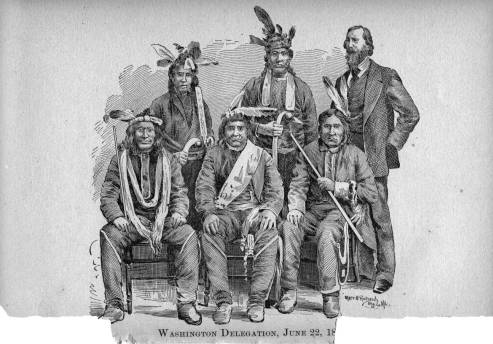
Likely Chief Buffalo of La Pointe: We are not 100% certain, but we are more certain than we have been about any other image featured in the Chief Buffalo Picture Search. This is a copy of a copy of a missing original by James Otto Lewis. Lewis was a self-taught artist who struggled with realistic facial features. Charles Bird King and Henry Inman, who made the first and second copies, respectively, had more talent for realism. However, they did not travel to Lake Superior themselves and were working from Lewis’ original. Therefore, the appearance of Big Buffalo may accurately show his clothing, but is probably less accurate in showing his actual physical appearance.
And while we’re on the subject of correcting misinformation related to images, I need to set the record straight on another one and offer my apologies to a certain Benjamin Green Armstrong. I promise, it relates indirectly to the “Big Buffalo” painting.
An engraving of the image in question appears in Armstrong’s Early Life Among the Indians.
Ah-moose (Little Bee) from Lac Flambeau Reservation, Kish-ke-taw-ug (Cut Ear) from Bad River Reservation, Ba-quas (He Sews) from Lac Courte O’Rielles Reservation, Ah-do-ga-zik (Last Day) from Bad River Reservation, O-be-quot (Firm) from Fond du Lac Reservation, Sing-quak-onse (Little Pine) from La Pointe Reservation, Ja-ge-gwa-yo (Can’t Tell) from La Pointe Reservation, Na-gon-ab (He Sits Ahead) from Fond du Lac Reservation, and O-ma-shin-a-way (Messenger) from Bad River Reservation.
In this post, we contested these identifications on the grounds that Ja-ge-gwa-yo (Little Buffalo) from La Pointe Reservation died in 1860 and therefore could not have been part of the delegation to President Lincoln. In the comments on that post, readers from Michigan suggested that we had several other identities wrong, and that this was actually a group of chiefs from the Keweenaw region. We commented that we felt most of Armstrong’s identifications were correct, but that the picture was probably taken in 1856 in St. Paul.
Since then, a document has appeared that confirms Armstrong was right all along.
[Antoine Buffalo, Naagaanab, and six other chiefs to W.P. Dole, 6 March 1863
National Archives M234-393 slide 14
Transcribed by L. Filipczak 12 April 2024]
To Our Father,
Hon W P. Dole
Commissioner of Indian Affairs–
We the undersigned chiefs of the chippewas of Lake Superior, now present in Washington, do respectfully request that you will pay into the hands of our Agent L. E. Webb, the sum of Fifteen Hundred Dollars from any moneys found due us under the head of “Arrearages in Annuity” the said money to be expended in the purchase of useful articles to be taken by us to our people at home.
Antoine Buffalo His X Mark | A daw we ge zhig His X Mark
Naw gaw nab His X Mark | Obe quad His X Mark
Me zhe na way His X Mark | Aw ke wen zee His X Mark
Kish ke ta wag His X Mark | Aw monse His X Mark
I certify that I Interpreted the above to the chiefs and that the same was fully understood by them
Joseph Gurnoe
U.S. Interpreter
Witnessed the above Signed } BG Armstrong
Washington DC }
March 6th 1863 }
There were eight Lake Superior chiefs, an interpreter, and a witness in Washington that spring, for a total of ten people. There are ten people in the photograph. Chequamegon History is confident that this document confirms they are the exact ten identified by Benjamin Armstrong.
The Lac Courte Oreilles chief Ba-quas is the same person as Akiwenzii. It was not unusual for an Ojibwe chief to have more than one name. Chief Buffalo, Gaa-bimaabi, Zhingob the Younger, and Hole-in-the-Day the Younger are among the many examples.
The name “Sing-quak-onse (Little Pine) from La Pointe Reservation” seems to be absent from the letter, but he is there too. Let’s look at the signature of the interpreter, Joseph Gurnoe.

Gurnoe’s beautiful looping handwriting will be familiar to anyone who has studied the famous 1864 bilingual petition. We see this same handwriting in an 1879 census of Red Cliff. In this document, Gurnoe records his own Ojibwe name as Shingwākons, The young Pine tree.

So the man standing on the far right is Gurnoe. This can be confirmed by looking at other known photos of him.
Finally, it confirms that the chief seated on the bottom left is not Jechiikwii’o (Little Buffalo), but rather his son Antoine, who inherited the chieftainship of the Buffalo Band after the death of his father two years earlier. Known to history as Chief Antoine Buffalo, in his lifetime he was often called Antoine Tchetchigwaio (or variants thereof), using his father’s name as a surname rather than his grandfather’s.

So, now we need to address the elephant in the room that unites the Henry Inman portrait of Big Buffalo with the photograph of the 1862-63 Delegation to Washington:

Wisconsin Historical Society
This is the “ambrotype” referenced by Patrick Jackson above. It’s the image most associated with Chief Buffalo of La Pointe. It’s also one for which we have the least amount of background information. We have not been able to determine who the original photographer/painter was or when the image was created.
The resemblance to the portrait of “Big Buffalo” is undeniable.
However, if it is connected to the 1862-63 image of Chief Antoine Buffalo, it would support Hamilton Nelson Ross’s assertions on the Wisconsin Historical Society copy.
Clearly, multiple generations of the Buffalo family wore military jackets.

Inconclusive: uncertainty is no fun, but at this point Chequamegon History cannot determine which Chief Buffalo is in the ambrotype. However, the new evidence points more toward the grandfather (Great Buffalo) and grandson (Antoine) than it does to the son (Little Buffalo).
We will keep looking.
Edwin Ellis Incidents: Number VIII
February 11, 2024
Collected & edited by Amorin Mello

Originally published in the September 1st, 1877, issue of The Ashland Press.
Transcribed with permission from Ashland Narratives by K. Wallin and published in 2013 by Straddle Creek Co.
… continued from Number VII.
My Dear Press: – Among the early names associated with Ashland, I must not omit to mention a few others.
1. E. F. Prince


came to Ashland early in 1857. He was brother-in-law to Martin Beaser and was induced by him to come from Buffalo to this place. He had been employed as clerk in a large ship building establishment, and when he left the employees of the yard showed their regard for him by presenting to him an elaborate and valuable set of silver service. He erected, in the same year, the house in which he now lives, on Main Street, in Beaser’s Division. From 1861 to 1872, he resided in Ontonagon and Duluth, but upon the commencement of work on the W.C.R.R., at Ashland, he returned to his old home, where he now resides.
Though still young and vigorous, he is entitled to be reckoned as one of the “Old Folk” of Ashland.
2. Oliver St. Germain
came to this place in 1856, and built a home on Main Street, adjoining Mr. Prince’s place. The house, with all its contents, was burnt down in the spring of 1858, inflicting a heavy loss upon Mr. St. Germain. He pre-empted a quarter section of land adjoining the town site, and cleared about twenty acres in 1858. The railroad passes through this clearing about a mile from town.
In the general wreck which followed the crash of 1857, he was compelled to abandon his Ashland home, and for some fifteen years lived at Ontonagon, Carp Lake, and Superior City. In 1872 he returned to his early home, and was among the first to build a house in Vaughn’s Division, in which he now resides. Though like the rest of us, he has encountered hard times, still, in the midst of discouragements, he is ever cheerful and hopeful, and determined never to give up, as long as a plank is left in the ship.
3.
I approach with reluctance another name, for I am conscious of my inability to do justice to his memory; nor fairly exhibit to this generation, his manly social, and religious character; nor make clear, in its true extent, the important part he acted in moulding and elevating the society, not of Ashland alone, but of the Counties of Ashland and Bayfield. In the annals of that History recorded by God himself, upon the tablets of Eternity, I doubt not his name will eclipse in true greatness and glory, those of Caesar and Napoleon.
I allude to
Rev. Hemenway Wheeler.

Reverend Leonard Hemenway Wheeler of the ABCFM Mission.
He was a native of Vermont, educated at Middlebury College, and at Andover Theological Seminary.

Reverend Sherman Hall of the ABCFM Mission.
~ Madeline Island Museum
Bishop Frederick Baraga of the Catholic Mission.
~ Madeline Island Museum
At the time of the completion of his course in theology, he had nearly decided to devote his life to the foreign mission field, in which he had near relatives. At this juncture, his attention was directed to the condition of the Chippewa Indians on Lake Superior. He offered his services to the American Board of Foreign Missions, who, besides the foreign work, had charge of the missions among the American Indians. His offer was accepted, and he was directed to join the Mission at La Pointe, then one of the stations of the Board, under the care of Rev. Sherman Hall, who still survives, at a very advanced age, at Sauk Rapids, in the state of Minnesota. Mr. Wheeler, in the early part of 1841, was married to Miss Harriet Wood, of Lowell, Mass., a refined and cultivated young lady, who, like her husband, was thoroughly imbued with the spirit of missions, and with true heroism, she left her cultivated home, and society, and went into what seemed banishment from civilization. We of this day, with our numerous steamboats, from Chicago, Detroit, Cleveland and Buffalo, – with the iron horse, drinking the waters of the lake at our very doors, and with the streams of commerce, and of social life sweeping by and among us in a constant flow, can have no idea of what it involved to come here for a life work, forty years ago.
At that time, there was a small settlement at the Sault. The site of the present beautiful and substantial city of Marquette was Indian hunting grounds. L’Anse, Houghton, Hancock, Calumet, Eagle harbor, Eagle River, Ontonagon, Ashland, Bayfield, Superior and Duluth were then in the unknown future. La Pointe was at that time the most important town on the Great Lakes. It had, in the 17th century, attracted the notice of the French explorers, and of the Jesuit missionaries, who made choice of it, as a trading post and as a mission station. The mission had been continued for near two centuries, and the trading post still held, though now under another race of men, was now the headquarters of the American Fur Company, where a factor resided, and where great warehouses were erected for the reception of the vast supplies of goods to be used in the Indian trade, which were brought once a year in the company’s vessel. From La Pointe these goods were distributed to various trading posts, scattered around the basin of Lake Superior, for more than four hundred miles, and extending inland indefinitely. Among these posts may be mentioned L’Anse and Iron River, in Michigan; Lake Flambeau, Montreal River, Lac Court Oreille, and St. Croix, in Wisconsin; Fond du Lac, Grand Portage, Vermillion Lake and Crow Wing, in the Territory of Minnesota, thus embracing the largest part of the waters flowing into the gulf.

View of La Pointe, circa 1843.
“American Fur Company with both Mission churches. Sketch purportedly by a Native American youth. Probably an overpainted photographic copy enlargement. Paper on a canvas stretcher.”
~ Wisconsin Historical Society
La Pointe was the emporium, the metropolitan city of this vast extent of country. It was the Mecca of the Ojibwas, occupying the extensive country I have named. To reach La Pointe and be buried there, was to be close to the gate of entrance to the “happy hunting grounds.” It was to him the “sweet Island of the blest.” With joy he hailed its sight, as he emerged from the forests in which months had been spent, gathering his pack of furs; and with regret he turned his lingering look upon it, as he again plunged into the wild wastes for his solitary hunt of half a year.

“Boardwalk leading to St. Joseph’s Catholic Church in La Pointe.” Photograph by Whitney & Zimmerman, circa 1870.
~ Wisconsin Historical Society
It was the scene of some of the most important treaties made with the Chippewas of the Northwest, by which they ceded to the United States, lands in extent sufficient to form respectable states. It was also the gathering place where the annual Indian payments were made for many years, and where the native chiefs, with their braves, delighted to hold their great councils.
Fifty years ago, no other place in this part of the West afforded access to so large a number of natives as did La Pointe. The truths made known to these “untutored minds,” and the light flashed into their dark understandings, by the preaching of the simple story of the Cross, could soon be carried to the head waters of the Mississippi, or to the dwellers on the tributaries of Hudson’s Bay, or of the Arctic Ocean. As a central point for carrying on this work of benevolence and love, it was unsurpassed.

Undated photograph of Hall & Wheeler’s ABCFM Mission Church at it’s original location on Sandy Bay (Middleport) before it was moved uphill onto Mission Hill.
~ Madeline Island Museum
It was the consideration of these facts that induced the American Board to establish a mission station at La Pointe, and to send thither for this purpose, about fifty years ago, the Rev. Sherman Hall. He had successfully planted the mission, and established a school at the time of the arrival of Mr. Wheeler.
Mr. Wheeler immediately entered actively upon his life work devoting himself to learning the Ojibwa language, and preaching by means of an interpreter, teaching in the school, and striving, in every way, to promote the spiritual and material welfare of the people.
To be continued in Number IX…
Tonight’s presentation: Trails & Towns before Washburn
February 6, 2024
Join us LIVE in person on Tuesday night to learn about the Ancient Trails and Ghost Towns that were here before Washburn was founded in 1883.
Presented by Chequamegon History’s Amorin Mello.
Hosted by the Washburn Heritage Association for the 13th Annual Tony Woiak Winter History Festival.
Apologies for the very short notice!
