Kah-puk-wi-e-kah: Cornucopia, Herbster, or Port Wing?
March 30, 2013

Official railroad map of Wisconsin, 1900 / prepared under the direction of Graham L. Rice, Railroad Commissioner. (Library of Congress) Check out Steamboat Island in the upper right. According to the old timers, that’s the one that washed away.
Not long ago, a long-running mystery was solved for me. Unfortunately, the outcome wasn’t what I was hoping for, but I got to learn a new Ojibwe word and a new English word, so I’ll call it a victory. Plus, there will be a few people–maybe even a dozen who will be interested in what I found out.

Go Big Red!
First a little background for those who haven’t spent much time in Cornucopia, Herbster, or Port Wing. The three tiny communities on the south shore have a completely friendly but horribly bitter animosity toward one another. Sure they go to school together, marry each other, and drive their firetrucks in each others’ parades, but every Cornucopian knows that a Fish Fry is superior to a Smelt Fry, and far superior to a Fish Boil. In the same way, every Cornucopian remembers that time the little league team beat PW. Yeah, that’s right. It was in the tournament too!
If you haven’t figured it out yet, my sympathies lie with Cornucopia, and most of the animosity goes to Port Wing (after all, the Herbster kids played on our team). That’s why I’m upset with the outcome of this story even though I solved a mystery that had been nagging me.
“A bay on the lake shore situated forty miles west of La Pointe…”
This all began several years ago when I read William W. Warren’s History of the Ojibway People for the first time. Warren, a mix-blood from La Pointe, grew up speaking Ojibwe on the island. His American father sent him to the East to learn to read and write English, and he used his bilingualism to make a living as an interpreter when he returned to Lake Superior. His mother was a daughter of Michel and Madeline Cadotte, and he was related to several prominent people throughout Ojibwe country. His History is really a collection of oral histories obtained in interviews with chiefs and elders in the late 1840s and early 1850s. He died in 1853 at age 28, and his manuscript sat unpublished for several decades. Luckily for us, it eventually was, and for all its faults, it remains the most important book about the history of this area.
As I read Warren that first time, one story in particular jumped out at me:
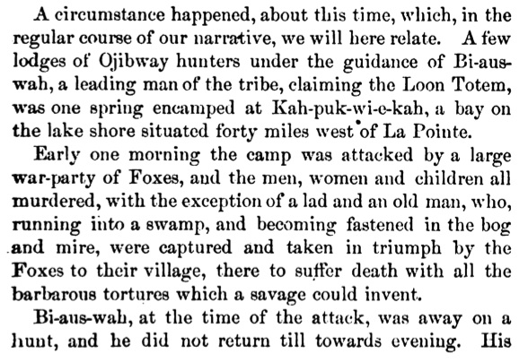
Warren, William W. History of the Ojibway Nation. St. Paul: Minnesota Historical Society, 1885. Print. Pg. 127 Available on Google Books.
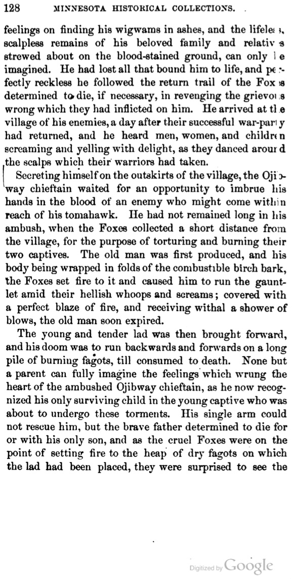
Pg. 128
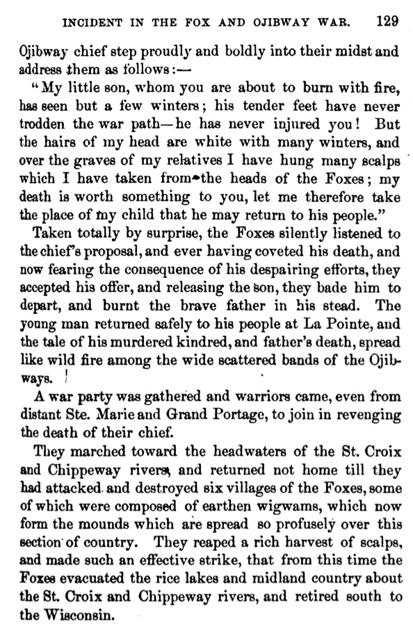
Pg. 129 Warren uses the sensational racist language of the day in his description of warfare between the Fox and his Ojibwe relatives. Like most people, I cringe at lines like “hellish whoops” or “barbarous tortures which a savage could invent.” For a deeper look at Warren the man, his biases, and motivations, I strongly recommend William W. Warren: the life, letters, and times of an Ojibwe leader by Theresa Schenck (University of Nebraska Press, 2007)
I recognized the story right away:

Cornucopia, Wisconsin postcard image by Allan Born. In the collections of the Wisconsin Historical Society (WHI Image ID: 84185)
This marker, put up in 1955, is at the beach in Cornucopia. To see it, go east on the little path by the artesian well.
It’s clear Warren is the source for the information since it quotes him directly. However, there is a key difference. The original does not use the word “Siskiwit” (a word derived from the Ojibwe for the “Fat” subspecies of Lake Trout abundant around Siskiwit Bay) in any way. It calls the bay Kah-puk-wi-e-kah and says it’s forty miles west of La Pointe. This made me suspect that perhaps this tragedy took place at one of the bays west of Cornucopia. Forty miles seemed like it would get you a lot further west of La Pointe than Siskiwit Bay, but then I figured it might be by canoe hugging the shoreline around Point Detour. This would be considerably longer than the 15-20 miles as the crow flies, so I was somewhat satisfied on that point.
Still, Kah-puk-wi-e-kah is not Siskiwit, so I wasn’t certain the issue was resolved. My Ojibwe skills are limited, so I asked a few people what the word means. All I could get was that the “Kah” part was likely “Gaa,” a prefix that indicates past tense. Otherwise, Warren’s irregular spelling and dropped endings made it hard to decipher.
Then, in 2007, GLIFWC released the amazing Gidakiiminaan (Our Earth): An Anishinaabe Atlas of the 1836, 1837, and 1842 Treaty Ceded Territories. This atlas gives Ojibwe names and translations for thousands of locations. On page 8, they have the south shore. Siskiwit Bay is immediately ruled out as Kah-puk-wi-e-kah, and so is Cranberry River (a direct translation of the Ojibwe Mashkiigiminikaaniwi-ziibi. However, two other suspects emerge. Bark Bay (the large bay between Cornucopia and Herbster) is shown as Apakwaani-wiikwedong, and the mouth of the Flagg River (Port Wing) is Gaa-apakwaanikaaning.
On the surface, the Port Wing spelling was closer to Warren’s, but with “Gaa” being a droppable prefix, it wasn’t a big difference. The atlas uses the root word apakwe to translate both as “the place for getting roofing-bark,” Apakwe in this sense referring to rolls of birch bark covering a wigwam. For me it was a no-brainer. Bark Bay is the biggest, most defined bay in the area. Port Wing’s harbor is really more of a swamp on relatively straight shoreline. Plus, Bark Bay has the word “bark” right in it. Bark River goes into Bark Bay which is protected by Bark Point. Bark, bark, bark–roofing bark–Kapukwiekah–done.
Cornucopia had lost its one historical event, but it wasn’t so bad. Even though Bark Bay is closer to Herbster, it’s really between the two communities. I was even ready to suggest taking the word “Siskiwit” off the sign and giving it to Herbster. I mean, at least it wasn’t Port Wing, right?
Over the next few years, it seemed my Bark Bay suspicions were confirmed. I encountered Joseph Nicollet’s 1843 map of the region:

That’s clearly Bark Bay being fed by the Apakwa River. (Library of Congress)
Then in 2009, Theresa Schenck of the University of Wisconsin-Madison released an annotated second edition of Warren’s History. Dr. Schenck is a Blackfeet tribal member but is also part Ojibwe from Lac Courte Oreilles. She is, without doubt, the most knowledgeable and thorough researcher currently working with written records of Ojibwe history. In her edition of Warren, the story begins on page 83, and she clearly has Kah-puk-wi-e-kah footnoted as Bark Bay–mystery solved!
But maybe not. Just this past year, Dr. Schenck edited and annotated the first published version of The Ojibwe Journals of Edmund F. Ely 1833-1849. Ely was a young Protestant missionary working for the American Board of Commissioners for Foreign Missions (ABCFM) in the Ojibwe communities of Sandy Lake, Fond du Lac, and Pokegama on the St. Croix. He worked under Rev. Sherman Hall of La Pointe, and made several trips to the island from Fond du Lac and the Brule River. He mentions the places along the way by what they were called in the 1830s and 40s. At one point he gets lost in the woods northwest of La Pointe, but he finds his way to the Siscoueka sibi (Siskiwit River). Elsewhere are references to the Sand, Cranberry, Iron, and “Bruley” Rivers, sometimes by their Ojibwe names and sometimes translated.
On almost all of these trips, he mentions passing or stopping at Gaapukuaieka, and to Ely and all those around him, Gaapukuaieka means the mouth of the Flagg River (Port Wing).
There is no doubt after reading Ely. Gaapukuaieka is a well-known seasonal camp for the Fond du Lac and La Pointe bands and a landmark and stopover on the route between those two important Ojibwe villages. Bark Bay is ruled out, as it is referred to repeatedly as Wiigwaas Point/Bay, referring to birch bark more generally. The word apakwe comes up in this book not in reference to bark, but as the word for rushes or cattails that are woven into mats. Ely even offers “flagg” as the English equivalent for this material. A quick dictionary search confirmed this meaning. Gaapukuaieka is Port Wing, and the name of the Flagg River refers to the abundance of cattails and rushes.
My guess is that the good citizens of Cornucopia asked the State Historical Society to put up a historical marker in 1955. Since no one could think of any history that happened in Cornucopia, they just pulled something from Warren assuming no one would ever check up on it. Now Cornucopia not just faces losing its only historical event, it faces the double-indignity of losing it to Port Wing.

William Whipple Warren (1825-1853) wrote down the story of Bayaaswaa from the oral history of the chief’s descendents.
So what really happened here?
Because the oral histories in Warren’s book largely lack dates, they can be hard to place in time. However, there are a few clues for when this tragedy may have happened. First, we need a little background on the conflict between the “Fox” and Ojibwe.
The Fox are the Meskwaki, a nation the Ojibwe called the Odagaamiig or “people on the other shore.” Since the 19th-century, they have been known along with the Sauk as the “Sac and Fox.” Today, they have reservations in Iowa, Kansas, and Oklahoma.
Warfare between the Chequamegon Ojibwe and the Meskwaki broke out in the second half of the 17th-century. At that time, the main Meskwaki village was on the Fox River near Green Bay. However, the Meskwaki frequently made their way up the Wisconsin River to the Ontonagon and other parts of what is now north-central Wisconsin. This territory included areas like Lac du Flambeau, Mole Lake, and Lac Vieux Desert. The Ojibwe on the Lake Superior shore also wanted to hunt these lands, and war broke out. The Dakota Sioux were also involved in this struggle for northern Wisconsin, but there isn’t room for them in this post.
In theory, the Meskwaki and Ojibwe were both part of a huge coalition of nations ruled by New France, and joined in trade and military cooperation against the Five Nations or Iroquois Confederacy. In reality, the French at distant Quebec had no control over large western nations like the Ojibwe and Meskwaki regardless of what European maps said about a French empire in the Great Lakes. The Ojibwe and Meskwaki pursued their own politics and their own interests. In fact, it was the French who ended up being pulled into the Ojibwe war.
What history calls the “Fox Wars” (roughly 1712-1716 and 1728-1733) were a series of battles between the Meskwaki (and occasionally their Mascouten, Kickapoo, and Sauk relatives) against everyone else in the French alliance. For the Ojibwe of Chequamegon, this fight started several decades earlier, but history dates the beginning at the point when everyone else got involved.
By the end of it, the Meskwaki were decimated and had to withdraw from northern Wisconsin and seek shelter with the Sauk. The only thing that kept them from being totally eradicated was the unwillingness of their Indian enemies to continue the fighting (the French, on the other hand, wanted a complete genocide). The Fox Wars left northern Wisconsin open for Ojibwe expansion–though the Dakota would have something to say about that.
So, where does this story of father and son fit? Warren, as told by the descendents of the two men, describes this incident as the pivotal event in the mid-18th century Ojibwe expansion outward from Lake Superior. He claims the war party that avenged the old chief took possession of the former Meskwaki villages, and also established Fond du Lac as a foothold toward the Dakota lands.
According to Warren, the child took his father’s name Bi-aus-wah (Bayaaswaa) and settled at Sandy Lake on the Mississippi. From Sandy Lake, the Ojibwe systematically took control of all the major Dakota villages in what is now northern Minnesota. This younger Bayaaswaa was widely regarded as a great and just leader who tried to promote peace and “rules of engagement” to stop the sort of kidnapping and torture that he faced as a child. Bayaaswaa’s leadership brought prestige to his Loon Clan, and future La Pointe leaders like Andeg-wiiyaas (Crow’s Meat) and Bizhiki (Buffalo), were Loons.
So, how much of this is true, and how much are we relying on Warren for this story? It’s hard to say. The younger Bayaaswaa definitely appears in both oral and written sources as an influential Sandy Lake chief. His son Gaa-dawaabide (aka. Breche or Broken Tooth) became a well-known chief in his own right. Both men are reported to have lived long lives. Broken Tooth’s son, Maangozid (Loon’s Foot) of Fond du Lac, was one of several grandsons of Bayaaswaa alive in Warren’s time and there’s a good chance he was one of Warren’s informants.

Caw-taa-waa-be-ta, Or The Snagle’d Tooth by James Otto Lewis, 1825 (Wisconsin Historical Society Image ID: WHi-26732) “Broken Tooth” was the son of Bayaaswaa the younger and the grandson of the chief who gave his life. Lewis was self-taught, and all of his portraits have the same grotesque or cartoonish look that this one does.
Within a few years of Warren’s work, Maangozid described his family history to the German travel writer Johann Kohl. This family history is worth its own post, so I won’t get into too much detail here, but it’s important to mention that Maangozid knew and remembered his grandfather. Broken Tooth, Maangozid’s father and Younger Bayaaswaa’s son, is thought to have been born in the 1750s. This all means that it is totally possible that the entire 130-year gap between Warren and the Fox Wars is spanned by the lifetimes of just these three men. This also makes it totally plausible that the younger Bayaaswaa was born in the 1710s or 20s and would have been a child during the Fox Wars.
My guess is that the attack at Gaapukuaieka and the death of the elder Bayaaswaa occurred during the second Fox War, and that the progress of the avenging war party into the disputed territories coincides with the decimation of the Meskwaki as described by the French records. While I don’t think the entire Ojibwe expansion of the 1700s can be attributed to this event, Ojibwe people in the 1850s, over a century later still regarded it as a highly-significant symbolic moment in their history.
So what’s to be done?
[I was going to do some more Port Wing jokes here, but writing about war, torture, and genocide changes the tone of a post very quickly.]
I would like to see the people of Cornucopia and Port Wing get together with the Sandy Lake, Fond du Lac, and Red Cliff bands and possibly the Meskwaki Nation, to put a memorial in its proper place. It should be more than a wooden marker. It needs to recognize not only the historical significance, but also the fact that many people died on that day and in the larger war. This is a story that should be known in our area, and known accurately.
If Cornucopia still needs a history, we can put up a marker for the time we beat Port Wing in the tournament.
Sources:
Ely, Edmund Franklin, and Theresa M. Schenck. The Ojibwe Journals of Edmund F. Ely, 1833-1849. Lincoln: University of Nebraska, 2012. Print.
Gidakiiminaan = Our Earth. Odanah, WI: Great Lakes Indian Fish & Wildlife Commission, 2007. Print.
Kohl, J. G. Kitchi-Gami: Wanderings round Lake Superior. London: Chapman and Hall, 1860. Print.
Loew, Patty. Indian Nations of Wisconsin: Histories of Endurance and Renewal.
Madison: Wisconsin Historical Society, 2001. Print.
Nichols, John, and Earl Nyholm. A Concise Dictionary of Minnesota Ojibwe. Minneapolis: University of Minnesota, 1995. Print.
Schenck, Theresa M. The Voice of the Crane Echoes Afar: The Sociopolitical Organization of the Lake Superior Ojibwa, 1640-1855. New York: Garland Pub., 1997. Print.
———— William W. Warren: The Life, Letters, and times of an Ojibwe Leader. Lincoln: University of Nebraska, 2007. Print.
Schoolcraft, Henry Rowe. Historical and Statistical Information Respecting the History, Condition and Prospects of the Indian Tribes of the United States. Philadelphia: Lippincott, 1853. Print.
Warren, William W., and Edward D. Neill. History of the Ojibway Nation. Minneapolis: Ross & Haines, 1957. Print.
Warren, William W., and Theresa M. Schenck. History of the Ojibway People. St. Paul: Minnesota Historical Society, 2009. Print.
White, Richard. The Middle Ground: Indians, Empires, and Republics in the Great Lakes Region, 1650-1815. Cambridge: Cambridge UP, 1991. Print.
“Wisconsin Historical Images.” Wisconsin Historical Society, n.d. Web. 30 Mar. 2013.
Witgen, Michael J. An Infinity of Nations: How the Native New World Shaped Early North America. Philadelphia: University of Pennsylvania, 2012. Print.
…a donation of twenty-four sections of land covering the graves of our fathers, our sugar orchards, and our rice lakes and rivers…
March 29, 2013

Symbolic Petition of Chippewa Chiefs: Original birch bark petition of Oshkaabewis copied by Seth Eastman and printed in “Historical and statistical information respecting the history, condition, and prospects of the Indian tribes of the United States” by Henry Rowe Schoolcraft (1851). Digitized by University of Wisconsin Libraries Wisconsin Electronic Reader project (1998).
For the first post on Chequamegon History, I thought I’d share my research into an image that has been circulating around the area for several years now. The image shows seven Ojibwe chiefs by their doodemag (clan symbols), connected by heart and mind to Lake Superior and to some smaller lakes. The clans shown are the Crane, Marten, Bear, Merman, and Bullhead.
All the interpretations I’ve heard agree that this image is a copy of a birch bark pictograph, and that it represents a unity among the several chiefs and their clans against Government efforts to remove the Lake Superior bands to Minnesota.
While there is this agreement on the why question of this petition’s creation, the who and when have been a source of confusion. Much of this confusion stems from efforts to connect this image to the famous La Pointe chief, Buffalo (Bizhiki/Gichi-weshkii).
In 2007, the Great Lakes Indian Fish and Wildlife Commission (GLIFWC) released the short documentary Mikwendaagoziwag: They Are Remembered. While otherwise a very good overview of the Lake Superior Ojibwe in this era, it incorrectly uses this image to describe Buffalo going to Washington D.C. in 1849. Buffalo is famous for a trip to Washington in 1852, but he was not part of the 1849 group.
At the time the GLIFWC film was released, the Wisconsin Historical Society website referred to this pictograph as, “Chief Buffaloʼs Petition to the President,” and identified the crane as Buffalo. Citing oral history from Lac Courte Oreilles, the Society dated the petition after the botched 1850-51 removal to Sandy Lake, Minnesota that resulted in hundreds of Ojibwe deaths from disease and starvation due to negligence, greed, and institutional racism on the part of government officials. The Historical Society has since revised its description to re-date the pictograph at 1848-49, but it still incorrectly lists Buffalo, a member of the Loon Clan, as being depicted by the crane. The Sandy Lake Tragedy, has deservedly gained coverage by historians in recent years, but the pictographic petition came earlier and was not part of it.
If the Historical Society had contacted Chief Buffaloʼs descendants in Red Cliff, they would have known that Buffalo was from the Loon Clan. The relationship between the Loons and the Cranes, as far as which clan can claim the hereditary chieftainship of the La Pointe Band, is very interesting and covered extensively in Warrenʼs History of the Ojibwe People. It would make a good subject for a future post.
After looking into the history of this image, I can confidently say that Buffalo is not one of the chiefs represented. It was created before Sandy Lake and Buffalo’s journey, but it is related to those events. Here is the story:
In late 1848, a group of Ojibwe chiefs went to Washington. They wanted to meet directly with President James K. Polk to ask for a permanent reservations in Wisconsin and Michigan. At that time the Ojibwe did not hold title to any part of the newly-created state of Wisconsin or Upper Michigan, having ceded these lands in the treaties in 1837 and 1842. In signing the treaties, they had received guarantees that they could stay in their traditional villages and hunt, fish, and gather throughout the ceded territory. However, by 1848, rumors were flying of removal of all Ojibwe to unceded lands on the Mississippi River in Minnesota Territory. These chiefs were trying to stop that from happening.
John Baptist Martell, a mix-blood, acted as their guide and interpreter. The government officials and Indian agents in the west were the ones actively promoting removal, so they did not grant permission (or travel money) for the trip. The chiefs had to pay their way as they went by putting themselves on display and dancing as they went from town to town.
Martell was accused by government officials of acting out of self interest, but the written petition presented to congress asked for, “a donation of twenty-four sections of land covering the graves of our fathers, our sugar orchards, and our rice lakes and rivers, at seven different places now occupied by us at villages…” The chiefs claimed to be acting on behalf of the chiefs of all the Lake Superior bands, and there is reason to believe them given that their request is precisely what Chief Buffalo and other leaders continued to ask for up until the Treaty of 1854.


This written petition accompanied the pictographic petitions. It clearly states the goal of the the chiefs was to secure permanent reservations around the traditional villages east of the Mississippi.
The visiting Ojibwes made a big impression on the nationʼs capital and positive accounts of the chiefs, their families, and their interpreter appeared in the magazines of the day. Congress granted them $6000 for their expenses, which according to their critics was a scheme by Martell. However, it is likely they were vilified by government officials for working outside the colonial structure and for trying to stop the removal rather than for any ill-intentions of the part of their interpreter. A full scholarly study of the 1848-49 trip remains to be done, however.
Amid articles on the end of the slave trade, the California Gold Rush, and the benefits of the “passing away of the Celt” during the Great Irish Famine, two articles appeared in Littell’s Living Age magazine about the 1849 delegation. The first is tragic, and the second is comical.
Along with written letters and petitions supporting the Ojibwe cause, the chiefs carried not only the one, but several birchbark pictographs. The pictographs show the clan animals of several chiefs and leading men from several small villages from the mouth of the Ontonagon River to Lac Vieux Desert in Upper Michigan and smaller satellite communities in Wisconsin. After seeing these petitions, the artist Seth Eastman copied them on paper and gave them to Henry Schoolcraft who printed and explained them alongside his criticism of the trip. They appear in his 1851 Historical and statistical information respecting the history, condition, and prospects of the Indian tribes of the United States.
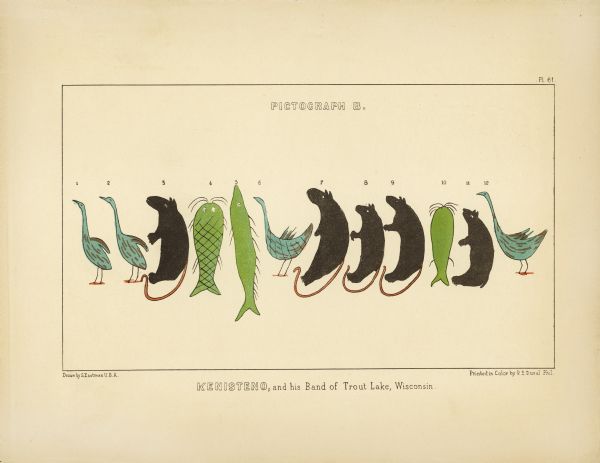
Kenisteno, and his Band of Trout Lake, Wisconsin
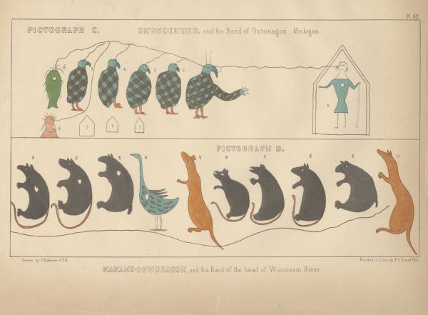
Okundekund, and his Band of Ontonagon, Michigan (Upper) Kakake-ogwunaosh, and his Band of the head of Wisconsin River (Lower)
According to Schoolcraft, the crane in the most famous pictograph is Oshkaabewis, a Crane-clan chief from Lac Vieux Desert, and the leader of the 1848-49 expedition. In the Treaty of 1854, he is listed as a first chief from Lac du Flambeau in nearby Wisconsin. It makes sense that someone named Oshkaabewis would lead a delegation since the word oshkaabewis is used to describe someone who carries messages and pipes for a civil chief.
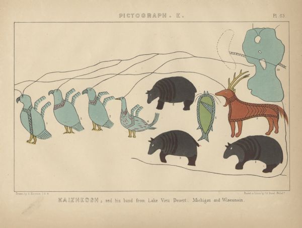
Kaizheosh [Gezhiiyaash], and his band from Lake Vieu Desert, Michigan and Wisconsin (University of Nebraska Libraries)
Long Story Short…
This is not Chief Buffalo or anyone from the La Pointe Band, and it was created before the Sandy Lake Tragedy. However it is totally appropriate to use the image in connection with those topics because it was all part of the efforts of the Lake Superior Ojibwe to resist removal in the late 1840s and early 1850s. However, when you do, please remember to credit the Lac Vieux Desert/Ontonagon chiefs who created these remarkable documents.
