Lac du Flambeau Reservation: 1842 Boundaries
October 23, 2021
“We do not feel disposed to go away into a strange & unknown country, we desire to remain where our ancestors lay & where their remains are to be seen.“
By Leo
Poking through old archives, sometimes you find the best things where you wouldn’t expect to. The National Archives have been slowly digitizing its Bureau of Indian Affairs microfilms, and for several months, I have been slogging through the thousands of images from the La Pointe Agency. For a change of pace, a few days ago, I checked out the documents on the Sault Ste. Marie Agency films and got my hands on a good one.
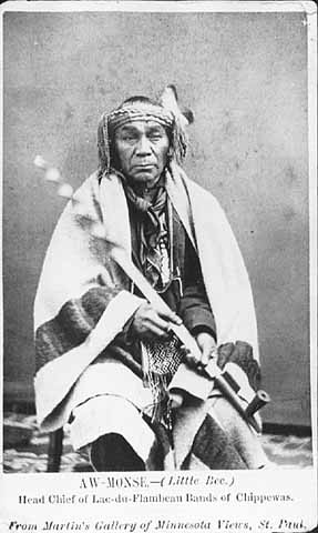
In September of 1847, Aamoons (Little Bee) and some headmen of what had been White Crow’s (Waabishkaagaagi) Lac du Flambeau were facing a serious dilemma. They were on their way home from the annuity payment at La Pointe where the main topic of conversation would certainly have been controversy surrounding the recent treaty at Fond du Lac. Several chiefs refused to sign, and the American Fur Company’ Northern Outfit opposed it due to a controversial provision that would have established a second Ojibwe sub agency on the Mississippi River. They saw this provision as a scheme by Missisippi traders to effect the removal west of all bands east of the Mississippi. Aamoons, himself, did not initially sign the document, but his mark can be found on the back of an envelope sent from La Pointe to Washington.
Our old friend George Johnston was returning to his Sault Ste. Marie home from the annuity payments when the Lac du Flambeau men summoned him to the Turtle Portage, near today’s Mercer, Wisconsin. They presented him a map and made speeches suggesting removal would be in direct violation of promises made at the Treaty of La Pointe (1842).
Johnston did not have a position with the American Government at this time, and his trading interests in western Lake Superior were modest. However, he was well known in the country. His grandfather, Waabojiig (White Fisher), was a legendary war chief at Chequamegon, and his parents formed a powerful fur trade couple at the turn of the 19th century. In the 1820s, George served as the first Indian Office sub-agent at La Pointe under his brother-in-law Henry Rowe Schoolcraft. During this time, he developed connections with Ojibwe leaders throughout the Lake Superior country, many of whom he was related to by blood or marriage.
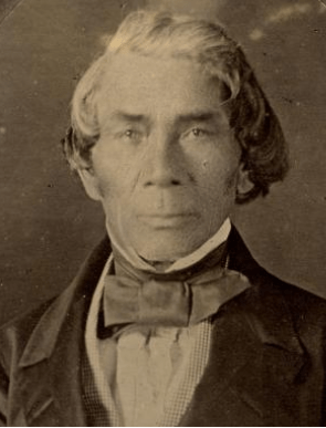
By 1847, Schoolcraft had remarried and left for Washington after the death of his first wife (George’s sister Jane). However, the two men continued to correspond and supply direct intelligence to each other regarding Ojibwe politics. Local Indian Agents attempted to control all communication moving to and from Washington, so in Johnston they likely saw a chance to subvert this system and press their case directly.
The document that emerged from this 174 year old meeting is notable for a few reasons. It further bolsters the argument that the Ojibwe did not view their land cessions in the 1837 and 1842 treaties as requiring them to leave their villages in the east. That point that has been argued for years, but here we have a document where the chiefs speak of specific promises. It also reinforces the notion that the various political factions among the Lake Superior chiefs were coalescing around a policy of promoting reservations as an alternative to removal. This seems obvious now, but reservations were a novel concept in the 1840s, and certainly the United States ceding land back to Indian nations east of the Mississippi would have been unheard of. Knowing this was part of the discussion in 1847 makes the Sandy Lake Tragedy, three years later, all the more tragic. The chiefs had the solution all along, and had the Government just listened to the Ojibwe, hundreds of lives would have been spared.
Finally, the document, especially the map, should be of interest to the modern Lac du Flambeau Band as it appears its reservation should be much larger, encompassing the historical villages at Turtle Portage and Trout Lake as well as Aamoons’ village at Lac du Flambeau proper. The borders also seem to approach, but not include the villages at Vieux Desert and Pelican Lake, which will be interesting to the modern Sokaogon and Lac Vieux Desert Bands.
Saut Ste. Marie
Augt 28th 1848.
Dear sir,
On reaching the turtle portage during the past fall; I was addressed by the Indians inhabiting, the Lac du Flambeau country and they presented me with a map of that region, also a petition addressed to you which I will herein insert, they were under an impression that you could do much in their behalf. The object of delineating a map is to show to the department, the tract of country they reserved for themselves, at the treaty of 1842, concluded by Robert Stuart at Lapointe during that period, and which now appears to be included in that treaty, without any reserve to the Indians of that region, and who expressly stated through me that they were willing to sell their mineral lands, but would retain the tract of country delineated on the map; This forms an important grievance in that region. I designed to have forwarded to you during the past winter their map & petition, but having mislaid it, I did not find it till this day, in an accidental manner, and I now feel that I am bound in duty to forward it to you.
The petition of the Chiefs Ahmonce, Padwaywayashe, Oshkanzhenemais & Say Jeanemay.
My Father (addressing Mr. Schoolcraft.)
Padwaywayashe rose and said, It is not I that will now speak on this occasion, it is these three old men before you, they are related to our ancestors, that man (pointing to Say Jeanemay will be their spokesman,
Sayjeanemay rose and said,
My Father, (addressing himself to Mr. Schoolcraft.)
Padwaywayahshe who has just now ceased speaking is the son of the late Kakabishin an ancient Chief who was lost many years ago in lower Wisconsain, and the white people have not as yet found him, and his Father was one of the first who received the Americans when they landed on the Island of Mackinac. Kishkeman and Kahkahbeshine are the two first chiefs that shook hands with the Americans, The Indian agent then told them that he had arrived and had come to be a friend to them, they who were living in the high mountains, and he saw that they were poor and he was come to rekindle their fire, and the American Indian Agent then gave Kish Keman a large flag and a large silver medal, and said to him, you will never meet with a bad day, the sky will always be bright before you.
My Father.
Our old chief the white crow died last dall, he went to the treaty held at St. Peters, and reached that point when the treaty was almost concluded, and he heard very little of it, and it was not him who sold our lands, it was an Indian living beyond the pillager band of Indians. We feel much grieved at heart, we are now living without a head, and had we reached St. Peters in time, the person who sold our lands would not have been permitted to do so, we should have made provision for ourselves and for our children, We do not now see the bright sky you spoke of to us, we see the return of the bad day I was in the habit of seeing before you came to renew my fire, and now it is again almost extinguished.
My Father;
We feel very much grieved; had my chief been present I should not have parted with my lands, and we find that the commissioner who treated with us, (meaning Mr. R. Stuart) has taken advantage of our ignorance, and bought our lands at his own price, and we did not sell the tract delineated on our map.
My Father;
We do not feel disposed to go away into a strange & unknown country, we desire to remain where our ancestors lay & where their remains are to be seen. We now shake hands with you hope that you will answer us soon.
Turtle portage 11th Sep; 1847.
In presence of}
Geo. Johnston.
Ahmonce his X mark
Padwaywayahshe his X mark
Oshkanzhenemay his X mark
Sayjeaneamy his X mark
To,
Henry R. Schoolcraft Esq.
Washington
N.B. All the country lying within the dotted lines embraces the country, the Chief Monsobodoe & others reserved at the Lapointe treaty and which now is embraced in the Treaty articles, and could not be misunderstood by Mr. Stuart and as I have already remarked forms an important grievance. All of which is respectfully submitted by
Respectfully
Your obt Servant
Geo. Johnston.
Henry R. Schoolcraft Esq.
Washington.
Respectfully referred from my files to the Commissioner of Indian Affairs
H.R.S
14th Feb 1849

Ahmonce (Aamoons), is found in many documents from the 1850s and 60s as the successor chief to the band once guided by his father Waabishkaagaagi (White Crow), uncle Moozobodo (Moose Muzzle), and grandfather Giishkiman (Sharpened Stone). The latter two are spelled Monsobodoe and Kishkeman in this document. Gaakaabishiinh (Kahkabeshine) “Screech Owl,” is probably the “old La Chouette” recorded in Malhiot’s Lac du Flambeau journal in the winter of 1804-05.
“The Americans when they landed on the Island of Mackinac” refers to the surrender of the British garrison at the end of the War of 1812, which is often referenced as the start of American assertions of sovereignty over the Ojibwe country. Despite Sayjeanemay’s lofty friendship rhetoric, it should be noted that many Ojibwe warriors fought with the British against the United States and political relations with the British crown and Ojibwe bands on the American side would continue for the next forty years.
The speaker who dominated the 1837 negotiations, and earned the scorn of the Lake Superior Bands, was Maajigaabaw or “La Trappe.” He, Flat Mouth, and Hole-in-the-Day, chiefs of the Mississippi and Pillager Bands in what is now Minnesota, were more inclined to sell the Wisconsin and Chippewa River basins than the bands who called that land home. This created a major rift between the Lake Superior and Mississippi Ojibwe.
Pa-dua-wa-aush (Padwaywayahshe) is listed under Aamoons’ band in the 1850 annuity roll. Say Jeanemay appears to be an English phonetic rendering of the Ojibwe pronunciation of the French name St. Germaine. A man named “St. Germaine” with no first name given appears in the same roll in Aamoons’ band. The St. Germaines were a mix-blood family with a long history in the Flambeau Country, but this man appears to be too old to be a child of Leon St. Germaine and Margaret Cadotte. From the text it appears this St. Germaine’s family affiliated with Ojibwe culture, in contrast to the Johnstons, another mix-blood family, who affiliated much more strongly with their father’s Anglo-Irish elite background. So far, I have not been able to find another mention of Oshkanzhenemay.
Moozobodo was not present at the Treaty of La Pointe (1842) as he died in 1831. Johnston may be confusing him with his brother Waabishkaagaagi
The timing of Schoolcraft’s submission of this document to the Indian Department is curious. In February 1849, a delegation of chiefs, mostly from villages near Lac du Flambeau was in Washington D.C. to petition President Polk for reservations. Schoolcraft worked to undermine this delegation. Had he instead promoted the cause of reservations over removal, one wonders if he could have intervened to prevent the Sandy Lake debacle.

Map of Lac du Flambeau Reservation as understood by Ojibwe at Treaty of La Pointe 1842. Apparently drawn from memory 11 September 1847 by Lac du Flambeau chiefs, copied and presumably labelled by George Johnston. Microfilm slide made available online by National Archives https://catalog.archives.gov/id/164363909 Image 340.

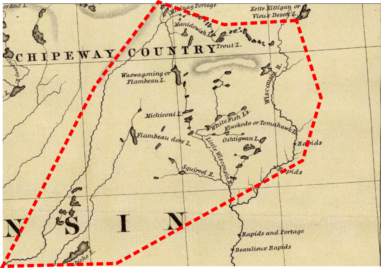

Alleged reservation boundaries agreed to in 1842 roughly superimposed over modern map. The Treaty of La Pointe (1854) called for three townships for the Lac du Flambeau Band–the white square on this map showing the modern reservation. Had the 1842 boundaries held, the reservation would have been much larger and included several popular resort communities.
