Porcupine Mountains Incidents
December 30, 2017
By Amorin Mello
The following is our transcription of Andrew Rundel’s original handwritten manuscript describing his time spent exploring for copper along the south shore of Lake Superior during the summer of 1846, particularly in the Porcupine Mountains. Andrew Rundel’s original handwritten manuscript is available online through the Wisconsin Historical Society’s Turning Points series.
Wisconsin Historical Society
Andrew Rundel Journal
“Andrew Rundel left Indiana in July of 1846 to prospect for copper on Lake Superior. His journal of the trip was probably kept for his family, and includes more about traveling than mining. From Chicago he sailed up the Wisconsin shore of Lake Michigan, and describes Racine, Mackinac, and the south shore of Lake Superior. Rundel appears only to have gone as far west as the Porcupine Mountains, but we include his account here for its descriptions of travel on the Great Lakes at the time the mining boom was beginning. This is his original handwritten manuscript; a printed version was published in Michigan History, June, 1949.”

1846
On the 11th of July with valliece in hand I left my wife and children for the far west I went on foot to Chicago. After swetting and toiling for two days I reached the city the weather was most excessive hot which rendered it very fatiguing walking. I put up at the farmers hotel but was soon sick of my bargain as a more filthy place I never stoped at and I would advise any one that may see this never to stop at the farmers hotel unless it has changed hands since I was there.
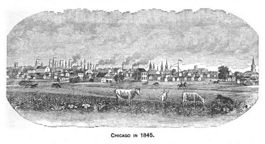
“Chicago in 1845.”
~ Marquis’ Hand-book of Chicago: A Complete History, Reference Book, and Guide to the City by Albert Nelson Marquis, 1885, page 17.
I remain’d in Chicago from Sunday night until monday at 9 Oclock in the morning when I went on board the S.B. James Madison for Mackinaw. The Madison is a good boat but not the first class. We were soon under way and on the broad bosoms on Lake Michigan.
Our boat stood up the Illinois side of the lake we passed, Little Port, Racine, Milwaukee and Che-boy-a-gon and then stood for the Michigan shore. All the above ports we stop’d at – Racine 25 or 30 miles before reaching Milwaukie is a beautifull place being elevated on a high pice of ground that overlooks the lake. The buildings all new and some of them handsome gave it a fine prospect appearance it has a population of near two thousand inhabitants. Milwaukee is also a fine business place and has a population of about five thousand. Soon after leaving the west shore of the lake we were out of sight of land this was the first time I ever was out of sight I had never form’d a correct Idea of the lake before nothing on every side but water the heavens above and earth beneath perhaps 900 or 1000 feet below.
We now had a head wind so heavy that our boat began to labour heavy to make head way. And now after six or seven hours that land could not be seen we came in sight of the Manitoe Islands, the wind increas’d until we had a pretty good gail. We were six hours in gaining the Island twelve miles distance here we lay until sometime in the night we put out for Mackinaw. The Island and all of the Michigan shore as far as I could see present a baran and gloomy appearance the country is covered with dwarf pine or stunted cedar or hemlock and to me had anything but a pleasant appearance. Some of the passengers tried to see beauty in the Manatue Islands and the evergreen that covered every thing but I must confess it was but little beauty I could get out of it. Soon after geting up the morning after leaving the Manitoe Mackinac was in view as we approached the Island the fort with its white walls and buildings on the summit of the hill became visible. The water of the straits were so clear that we could see the bottom when the water was thirty or forty feet deep. We are now from the best account four hundred and eighty five miles from Chicago. The harbour and straits of Mackinaw are verry pretty here you may see the Indian with his bark canoe as he glides over the pure waters of the bay like a sea-bird. Here are several different tribes of Indians the Chippeways are the most numerous and in fact they appear to be the strongest tribe in the whole N. Western country their territory is very extencive extending from this to the Mississippi and taking the whole of L.S. The Manomone or wild rice eaters inhabit the country wash’d by the Manomone River this river empties in to Green bay there is also the Winebago Indians that some times come to this place to trade and perhaps others.
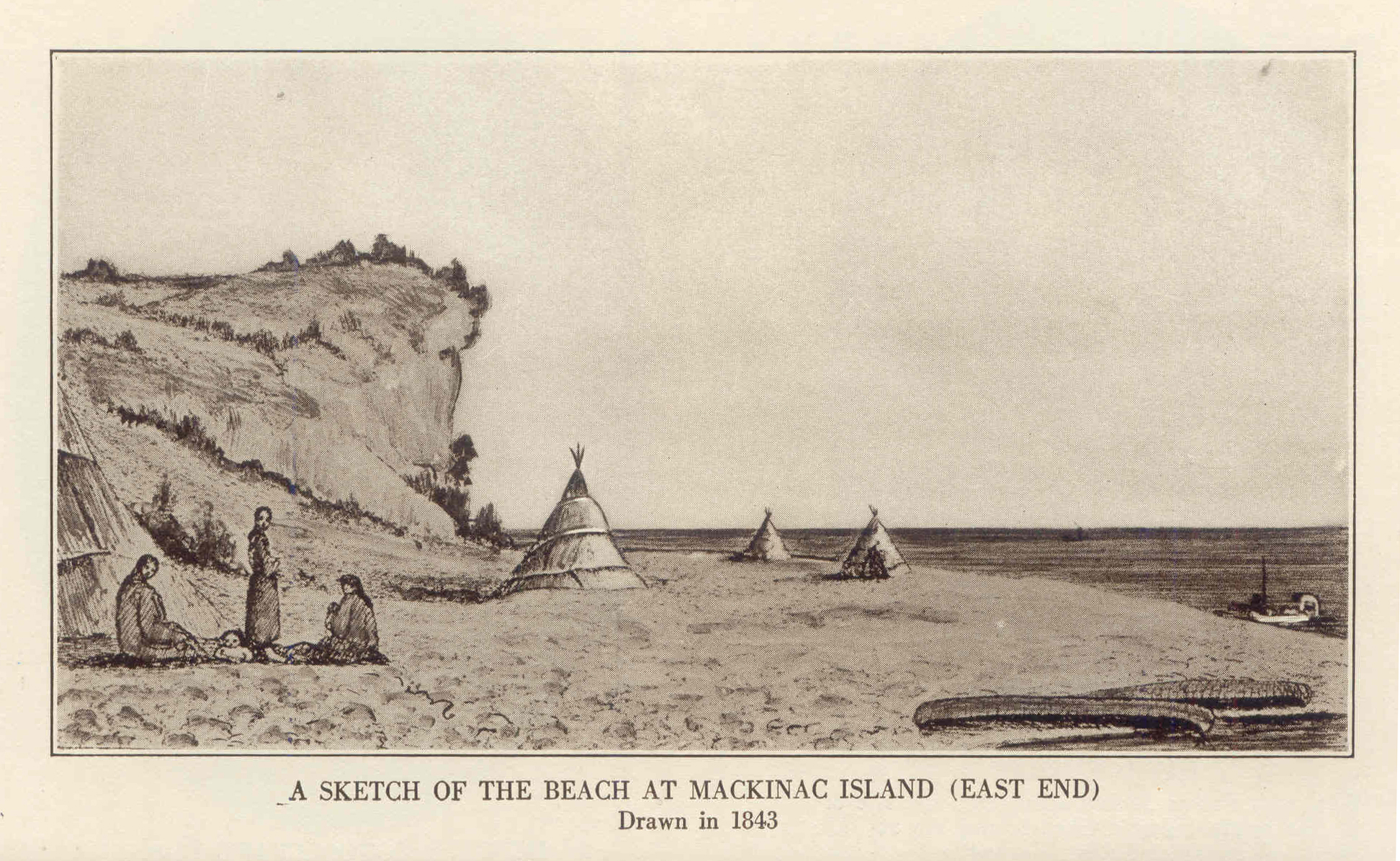
1843 Drawing of Mission Point Beach at Mackinac Island, Michigan
~ Historic Mackinac, Volume 1, by Edwin Orin Wood, 1918, facing-page 367.
The great variety of fishing boats and bark canoes with their sails and oars that constantly cover the water gives to Mackinaw a very beautifull appearance some of the boats coming in with fish others going out some palled by squaws and others by french and in fact here you see every boddy. I mean by that – people from every clime for I never saw so mixed a population in my life. Every thing appears to be mix’d on half-breeds. Although there appears to be blood from almost every nation it certainly appears to have a small coulering of Indians with it.
Mackinaw is a very interesting place in many perticulars, certainly for situation, history and wild scenery it is the most interesting Island in our country. I will quote from travelers its appearance as it is approach’d from lake Huron “We approach it through an armor of Islands, Drummond and Manitoulin [dainly?] seen” on our east and Boisblane and Round in our western side. Stretching across our path in front is Mackinaw painted against the clear blue skie. The Island of Mackinaw or Mackinac or Michilimackinac is a high and bold bluff of limestone about three hundred feet above the water covered with evergreen principally stunted pine and hemlock.
Its name signifies in the Indian tongue big turtle as it is something in shape of this animal. At the foot of the bluff are strewd the buildings of the town.

Painting of Fort Mackinac by Seth Eastman in 1761.
~ United States Army Center of Military History
The United States fort is verry pretty and verry conspicuous as we approach it from either way in the distance it has much the appearance of a row of white buildings lineing the summit of the hill. The stars and stripes of our country waved over the fort. And the booming sound of a cannon now rolls over the waters of the straits. I had to remain here until the next day, and it gave me an opportunity of visiting or rambling over the Island. On the summit and north of the fort is a natural bridge of white limestone rock stretching a cross a deep chasm, from this we could look down in to the waters of lake Huron. I saw many curiosities here which I cannot here give. This place was settled by the French as early as sixteen hundred and seventy three.
It is very singular that the Indians would allow the French to come among them and even marry with them, but when any other nation came among them they were masacreed or driven from the country.
On the opposite shore is to be seen the old fort of Mackinaw in ruins. It was built by the English before the revolutio and man’d as a garison. This fort was taken by the Indians under the command of their chief Pontiac by stratagem, and every person was masacre’d. After the masacree of fort Mackinaw the Indians march’d immediately for Detroit where was also a fort held by English but the commander mistrusted them and saved the fort.
Again I went on board the S. B. Gen’l Scott for the Sault which is ninety miles distant. As we pass out of the straits for the sault we find our selves on the waters of Lake Huron Islands are to be seen on every side. The distant to the river from Mackinaw I think is not far from thirty miles. It is a beautiful evening and the sun sets in lake Huron and to me it was grand beyond any thing I ever saw.
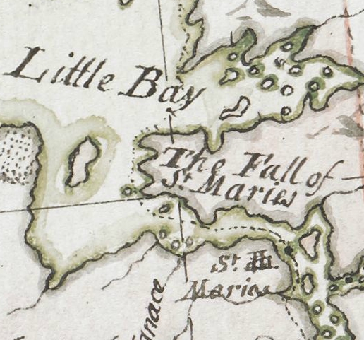
Detail of Sault Ste Marie from Carver [Jonathan], Captain. Journal of his travels with maps and drawings, 1766.
~ Boston Public Library
Mackinaw The river St. Maries, as you approach it appears like a group of Island and would be different for an inexperianced hand to tell where to find the river and in fact after you are farely in the river there is one continued group of Islands and small lakes the most of the way to the Sault. These Islands are mostly covered with a stunted growth of evergreen trees of which the hemlock is predominant. This is the general character of the timber although I notised in some places a fine growth of sugar maple. The Lakes in this river, or that this river runs through are very prety and abound with fish in great abundence some of the lakes are several miles long and from one to two miles wide. Around these lakes and at different points an the river Indian wigwams are seen and occasionally Squaws in their bark canoes may be seen gliding across the river with as much grace and eas as tho they were the godesses of those sylvan retreats. While on our passage ther was an englishman came on board with two squaws. I learned he was the british Indian agent and that one of the squaws was his wife he appeared to possess wealth and his two squaws were trimed out in fine stile and no doubt wer a source of curiosity and amusement to some southern ladies and gentlemen that were on board on a trip of pleasure to spend the heat of summer at the north.
Our boat took a schooner in toe for the sault as the water is too rappid for schooner in places unless they have a very fair wind. Thus armed we arrived at the Sault after having been on board twenty four hours the boat however lay by over night in the river on account of the dificulty of the channel.
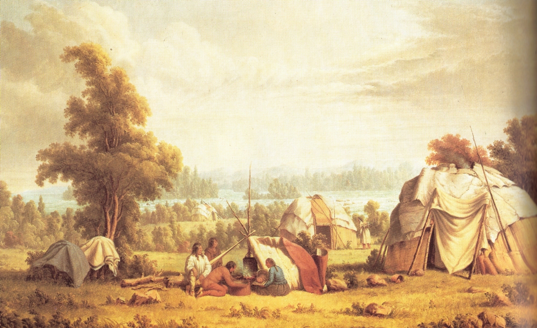
“Ojibwa village near Sault Ste Marie” by Paul Kane in 1845.
~ Wikipedia.org
The inhabitants of the Sault ar like those of Mackinaw a perfect mix’d mixed set of inhabitants every thing appears mixed except the whitefish which are pure and the finest I ever saw. The population perhaps may be two hundred. There is nothing remarkable at this place except the rappids or shute which is a fall of about twenty two feet in the distance of three fourths of a mile here is fine fishing and the most of the fish are taken by the Indians and consider themselves the rightfull owners of this outlet of Lake Superior.
I was fortunate in finding an excellent Schooner just ready to sail for the copper region of Lake Superior. We were soon under way and gliding up to the lake from the Sault. I was surprised to see so many vessels on the waters of Lake Superior not less than eight were in sight one propeller and the Julia Palmer S. B. now send out their steam on this lake.
Our vessel stood directly for Copper harvour which is 225 miles from the Sault we wer soon out of sight of land Lake Superior appears like an ocean to a land lubber like my self, to be twenty hours out of sight of land with a fair wind gives me an Idea of the vastness of this lake I never had before. Pigeons came on board and sat in the riggins and could scarcely be indus’d to leave the vessel. They were lost in the fog.
Stanards rock lays nearly on the track from Copper harbour to the Sault and is a very dangerous rock raising not more than two feet out of the water in a calm and when the sea is rough the water runns entire over it so that in a fog or in a dark night vessels might easy run on to it. The rock is only a five feet square above the water or in sight and to run on to it would be inevitable destruction this rock is thirty or forty miles from any land. On one side of this rock a line has been let down twelve hundred feet and no bottom found on the other it passes off gradual. The rock is said to be Traprock. After passing this rock we soon came in sight of the Manitoe Islands and then Keweenaw point. Copper harbour is situated on this point. As we approached Copper harbour the scenery appears bold and rock and no enterance can bee seen to the harbour until we actually enter where the harbour spreads out and we soon find our selves in a beautifull harbour safe from the sea in any direction.
…
“Cleveland North Western Lake Company was formed by Messrs. Cyrus Mendenhall, Samuel Richardson, Horatio W. Converse and James A. Converse.”
~ OldAlgonquin.net
Mendenhall ran his vessel the Algonquin in to this harbour a few years ago (I think in ’40) in a gale the first vessel that ever entered this beautiful harbour. Six or eight vessels may now be seen at a time.
Ft. Wilkins is situated here and was man’d by a small garison until the last summer when the troops were ordered to Texas.
Lake Fanne hoe lays back of Copper harbour and passes entirely around the fort except a few rods at each end of the lake.
The general apperances of the country at this place has a barren rocky aspect. Nothing can grow here but stunted cedar, pine and hemlock and these must depend mostly on the rocks for the support of I saw no place wher soil enough could be got for a potatoe patch. The rock is Trap and is traversed by veins of white spar which contrast finely with the dark Trap rock. The copper men of this neighbourhood have not been verry successfull. Mendenhall has charge of a location and some interest in it which he thinks will be valuable.
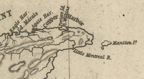
Detail of Porter’s Island and Fort Wilkins at Copper Harbor along the tip of the Keweenaw Peninsula from Map of the Mineral Lands Upon Lake Superior Ceded to the United States by the Treaty of 1842 With the Chippeway Indians.
~ Wisconsin Historical Society
As we leve Copper harbour and pass up the lake there is the same general appearance. We pass Aggate harbour and Eagle harbour and arrive at Eagle River twenty miles from Copper harbour. Here is the famous Eagle Cliff mine said to be the richest mine in the world. Whether such will prove to be the fact or not I am not a competent judge. Mendenhall has a considerable interest in this mine but do not know to what extent. Not far from this is the Copper falls river where the great copper rock is found this piece of pure copper is of many tons weight I suppose no one knows how arge as they have not found its size the last accounts.
There ar many valuable mines in this vicinity. In the At Eagle river and vicinity the whole forest appear’d to have suffered from fire the whole country was black. The fire raged with such fury that it appears to me every tree must be killed for miles around several houses were burned and other damages sustained.
Keewenaw point which I have just been describing is a point of land that runs nearly in to the middle of the lake from the south side.
After leaving copper harbour (which is situated directly on the point) the cost bears a little S. of W. for twenty miles and then bears S. W. so that after passing up the lake sixty or seventy miles it cannot be more than twenty five miles across to the lake. Directly east from Copper harbour down the lake the cost bears almost south. So that this point may be called a peninsula.
Portage lake crosses this peninsula so that small boats may cross with a portage of about one mile. The distance across here may be 20 miles and to go round would be not less than 90 miles.
As we pass up the lake the coast changes its appearance insted of a Trapcrock cost we find the shore generally lined with a redish sand stone though in places there is a beautifull sand beach. At Portage lake I first found Mendenhall and here I took my first lesson in exploring soon after I arrived Mendenhall left and left me in charg of the company of explorers.
Our company consisted of five men besides my self six in all one of the men staid at the camp and acted as cook when our work lay back from the lake 9 or 10 miles as some of it did. Each man took his blanket and provisions to last several days. Our blankets were done up in the form of a pack with our provisions in it each man having a good collar for the purpose thus equipt we were ready for our work. After searching all day for copper we generally camped by the side of some stream, built a five, cooked our supper, took our blanket, and lay down for the night, with the heavens for our curtains, and the earth for our pillow, and thus we continued until our provisions run out, when we would again return to camp and renew our stock and repeat the same thing over. I have been thus perticular in describing our manner of exploring, it being descriptive of all of our exploring.
After spending about a month her among Hirnas Wolverenes and Jackalanters and floundering among swamps and moors and climbing hills we left these diggins and went up to Misery river thirty miles farther up the lake to repeat the same thing over. I might say here we found no copper at the portag but several Beaver habitations. There is no game in the woods except Beaver and Porcupines scarcely a bird except pheasents no wild fruit no flowers no nothing except cedar swamps of the worst kind. After leaving this we soon found the coast rocky. Walls of red sandstone rose from the waters edg or directly out of the water to the heighth of a hundred feet perpendicular here we had a beatifull view of these rocks as our traveling is in a Batteau and must keep close to the shore for safety. (I might here state the only way of traveling in summer is in Batteaus with sail and oars we coast along from place to place as business calls. These rocks have a beautifull appearance caverns are wash’d and worn in to the base of these rocks and looks as tho some sea nymph might have had her pallace here. My mind became so much excited I almost expected to see some of those fabled beauties pressing out at us as we passed along from some of those windows or loopholes in the wall or see them sitting on the point of some prominent rock, attending to her toilet but I didn’t see any though, nor did I hear them sing. Rivulets of clear pure water came rolling over these rocks from the adjacent high land and form’d beautifull cascades inviting the traveler to view and admire their pur waters before forever lost in the mighty Superior. Some of these waterfalls appear to leap from the top of the rock, and plunge in the lake several feet from their base while others cling to the rock until they reach the waters of the lake. I regret much I cannot visit the pictured rocks which are farther down the lake than where we first touched on the south side. They are said to be beautiful when view’d at a short distance from the water, presenting a vast wall of red sandstone rocks most beautifully pictured. The Indians have some superstitious notions of these rocks of which I know but little.
Nor shall I be able to visit those stupenduous monuments on the north shore of the lake. These rocks are trap and are said to rais perpendicularly out of the water to the great heighth of thirteen hundred feet. These rocks have undoubtedly been thrown up by some volcanic action.
It is the common received opinion that this entire trap range has been thrown up by some violent eruption and has burst up through the upper layer of sandstone. Veins of which spar travers these Trap rocks in every direction and nearly all copper is found in them. Occasionally however veins of oars are traced some distance from the Trap into the Conglomoret rock wher the two unite.
The oars that are formed are the Red, Black and Grey Oxides also, Red, Black, Grey, and Yellow Sulpherets but in many places large quantities of Native copper is found. Pieces or bolders of pure copper is sometimes found weighing many tons. Of these copper rocks the one at Copper falls mine is most remarkable of which I have already mentioned. I saw one from the Ontonagon river weighing over Sixty hundred. This piece of copper had a good deal of pure silver in it. These copper bolders sometimes lay in veins in the rock and sometimes they are found loose on the surface of the ground at a distance from any vein yet discovered. They appear as though they had been melted and run into masses without any form, and of course rough enough.
I will now return and pursue our course up the lake the cost is rough and rocky most of the way from Portage up to the mouth of Misery river. There is but one stream of any note and that is Graverod river. This is a small stream large enough for a good mill stream and furnishes a toelerable good boat harbour. We ran our boat into this tream with a pretty good sea at our heals, and got well wet as all hands had to jump in to the water to save our boat from breaking on the rocks. Here we camp’d for the night nor did we get away the next day the sea being to rough for our small boat.
~ History of the Upper Peninsula of Michigan by The Western Historical Company, 1883 (transcribed by Debi Hanes).
Misery river is a muddy sluggish looking stream different from any water I have seen since I came on the lake it is however a good boat harbour and is a point where most boats stop in passing up or down after landing at the mouth of Misery, securing our boat and getting all things ready. We started for our work which lay back about ten miles from the lake. Here we repeated the same thing over as at the Portage. And with no better success. After spending near a month here we again pact all things up and started for the mouth of Misery. As we pass up the lake we pass Sleeping river Flint Steel and firesteel rivers all of which are small streams but furnish good boat harbours and arrive at the Ontonagon about twenty miles distant. The Ontonagon is a fine stream and the only stream that I have seen that deserves the name of river. It is 75 or 100 yds wide at its mouth and is a good harbour for small vessels having a depth of water on the bar of about seven or eight feet. This place must always be a place of conciderable importance it is in the middle of the mining destrict and the largest river that empties in to the south side of the lake. I understand there has been a new County form’d and this place is lix’d on as the County seat, at present the mouth of the river is held by one Jim Paul and claims the most eligable cite for a town by preemption and prevents any other one from improving it. He is a notorious character he has two small houses one he pretends to keep as a tavern and the other as a dogery to sell liquors. It goes by the name of Paul’s dedfall. It is one of the most miserable places I ever saw. I can scarcely repress my feelings at the insult given by it to the entire waters of Lake Superior. I hope the time is not far distant when this stain will be wash’d from the shores of the lake. Mendenhalls mine lays up the river, and as we pass up we find rich bottom bands covered with a luxurient growth of vegitation quite diferent from the shore of the lake. The scenery is beautifull, amongst the trees that line the banks of the streams is the mountain ash one of the most beautifull ornament trees I ever saw, they were loaded with brillient red fruit and are said to retain its fruit all winter.

Detail of Ontonagon River, “Paul’s Cabin,” the Ontonagon Copper Boulder, and the Porcupine Mountains from Map of the Mineral Lands Upon Lake Superior Ceded to the United States by the Treaty of 1842 With the Chippeway Indians.
~ Wisconsin Historical Society
The stream is broad and deep the distance I have been up which is about five miles from its mouth. The indians have fine sugar camps on this stream but the pail faces or Che-moco-man are beginning to occupy them and the red man must leave.
At this point (five miles from the lake) Mendenhall has a warehouse where all of the goods and supplies for the Mendenhall location are landed.
~ mindat.org
The location is five or six miles from the river. Here are the best improvements I have ever seen since I have been on the lake. He has seven or eight buildings for different purposes and several acres of land cleared last season he rais’d potatoes and Turnips enough for the use of the location. They also had plenty of cucumbers and squashes with some other garden vegetables. This mine is conducted with order and every thing has a business appearance.
They have a chaplain and preaching every sunday. Their preacher works in the mine weekdays and preaches on sundays. The miners are all english men from the cornish mines of England. The Ontonagon destrict, it is thought will become one of the best mineing destricts on the lake.
Iron river fifteen miles up from the mouth of the Ontonagon is a considerable of a stream next in size to the Ontonagon that I have seen this is a good boat harbour but not large enough for vessel. It is a great resort for Indians.
From Iron river to the Purcupine mountains the coast is mostly rocky and rather dangerous costing. For further description of this cost see Note book.
From Iron river to the Porcupine mountains or to the Lone Rock is fifteen miles. Lone Rock is a detach’d rock situated about 1/4 of a mile from the main land and raises out of the water perhaps twenty feet. Nothing grows on the rock except some wild roses which are said to be beautifull. This rock is trap and is fill’d with veins of white spar it is known to all voyagers as a point in counting distances. The Indians call it Me-ne-sawbic. This rock is the corner of the location I have been on this winter and the mine is call’d the lone rock mine.
The Porcupine Mountains ar ranges of mountains or hills runn paralell to the lake or nearly so at this place they approach verry near the lake. And are several ridges laying paralell to each other.
The first ridg is Conglomerate, the second is Trap and also the third. They rais by steps the first not being so high as the next and the third being higher still so that a person on the top of the third range can overlook the others and see the lake. These hills or mountains have a gradual incline to the north and are not very steep, but their south side is verry abrupt and form perpendicular walls of rock from one to three hundred feet high. In the vally between the second and third range Carp River winds its way to the lake running parallel to it for many miles. This river is a small stream of pure water of sufficient size for mill purposes. It abounds with Trout in great abundance. Here is also plenty of Beaver on it. The scenery is bold and grand for him who can enjoy mountain scenery.
The view from some of the higher points of the mountains where Lake Superior is spread out before you on one side and the mountains with their eternal rocks and deep vallies with their small rivers and mountain lakes, on the other presents certainly one of the most grand, and sublime pictures I ever witness’d. I have recently visited the Bellmont mine about five miles from the Lone Rock mine. Here I find the upheave to be greater than I have seen at any other part of the range being as near as I can judg seven or eight hundred feet nearly perpendicular. It is also the highest point of the second range of mountains or second ridg from the lake. Being 1000 feet above Lake Superior. Myself in company with Geo Rice in the evening assended the highest point where we had a beautifull view of the surrounding country and of Lake Superior which was now calm and smooth as a mirror. How shall I paint that sunset scene on Lake Superior as view’d from the top of the Porcupine Mountains. I have been toss’d on Enis billows, I have heard the thunder of Lake Michigan as she in her magesty lash’d her impenetrable barier but never have I seen nature in all her georgeous beauty until I viewed her at evening from these mountains. As the sun approach’d the christal floor of Lake Superior the blue waters were painted and ting’d with every possible hue and sparkled like diamonds shortly the brilliants appeared to concentrate until there was but one bright path from us to the sun and formed a beautiful bridg from earth to heaven. I had always been accustomed to seeing the sun abov me but now it was below near the water, on the water, and under the water, and now the sun sleeps in Lake Superior. The whole western skies are painted with rose and yellow and green and reflected back on the blue waters of the lake as though nature was determin’d to try her hand at fancy work once more before returning to rest.
We lingered here until one star made its appearance soon follow’d by all the bright lights of Heaven (if I may be allowed to quote from Scripture) until the whole deep blue was set with Jewells.
This reminds me of that pretty vers my litl girls us’d to repeat
Twinkle twinkle pretty star
Cant you tell us where you are
Up above the world so high
Like a diamond in the skie
We lingered here until the hour reminded us we must try to find our way down to the cabbin.
This was the last time I expect to visit this part of the mountains I therefor determin’d to assend thos lofty cliffs and have a morning view. Soon a darling radiance sot up from behind the mountains and the King of day made his appearance as if to greet his favorurite lake.
Deep in the vally lay that beautifull mountain lake with the wild ducks sporting on its bosom or whirling in gracefull circles over its shining waters. After spending an hour or two I bid adieu to this grand and magnificent Observatory of nature probably forever.

Hand-drawn chart of Lake Superior in Andrew Rundel Journal.
Indian Agency’s Explanation of the 1854 Treaty
December 13, 2017
By Amorin Mello
Treaty Commissioner Henry C. Gilbert’s
Explanation of the Treaty Concluded in 1854
with the Assistance of David B. Herriman
Transactions of the Wisconsin Academy of Sciences, Arts and Letters:
Volume 79, No. 1, Appendix 5
Office Michigan Indian Agency
Detroit October 17th, 1854
Sir

Mackinac Indian Agent
Henry Clark Gilbert
~ Branch County Photographs
I transmit herewith a treaty concluded at LaPointe on the 30th Ultimo between Mr. Herriman and myself as Commissioners on the part of the United States and the Chippewas of Lake Superior and the Mississippi.
On receiving your letters of August 10th, 12th, and 14th, relative to this treaty, I immediately dispatched a special messenger from this place by way of Chicago, Galena and St. Paul to Mr. Herriman at the Crow wing Chippewa Agency transmitting to him your letter requesting him to meet me at LaPointe with the Chiefs and Headmen of his Agency at as early a day as possible. I adopted this course in preference to sending a messenger from La Pointe on my arrival there for the purpose of saving time and I was thus enabled to secure the attendance of Mr Herriman and the Mississippi Chiefs some 10 or 12 days earlier than I could otherwise have done.
I left for LaPointe on the 26th of August last and arrived there the 1st day of September – Mr Herriman meeting me there the 14th of the same Month.
By this time a large number of Indians had assembled – including not only those entitled to payment but all those from the Interior who live about Lakes de Flambeau and Lake Courteilles. The Chiefs who were notified to attend brought with them in every instance their entire bands. We made a careful estimate of the number present and found there were about 4,000. They all had to be fed and taken care of, thus adding greatly to the expenses attending the negotiations.

Charles William Wulff Borup and Charles Henry Oakes married into the La Pointe mixed blood Beaulieu family; built the American Fur Company’s new La Pointe outfit during the 1830’s; sold La Pointe to Julius Austrian during 1853; and started the first bank in Minnesota during 1854 at St. Paul.
~ 1854 banknote from HeritageAuctions.com
A great number of traders and claim agents were also present as well as some of the persons from St. Paul’s who I had reason to believe attended for the purpose of preventing if possible the consummation of the treaty. The utmost precautions were taken by me to prevent a knowledge of the fact that negotiations were to take place from being public. The Messenger sent by me to Mr Herriman was not only trust worthy but was himself totally ignorant of the purport of the dispatches to Major Herriman. Information however of the fact was communicated from some source and the persons present in consequence greatly embarrassed our proceedings.
After Major Herriman’s arrival we soon found that the Mississippi Indians could not be induced to sell their land on any terms. Much jealousy and ill feeling existed between them and the Lake Superior Indians and they could not even be prevailed upon to meet each other in council. They were all however anxious that a division should be made of the payments to become due under former existing treaties and a specific apportionment made between the Mississippi and the Lake Superior Indians and places of payment designated.
Taking advantage of this feeling we proposed to them a division of the country between them and the establishment of a boundary line, on one side of which the country should belong exclusively to the Lake Superior and on the other side to the Mississippi Indians. We had but little difficulty in inducing them to agree to this proposition and after much negotiation the line designated in the treaty was agreed upon.
We then obtained from the Lake Indians a cession of their portion of the Country on the terms stated in the treaty. The district ceded embraces all the mineral region bordering on Lake Superior and Pigeon river & is supposed to be by far the most valuable portion of their country. But a small portion of the amount agreed to be paid in annuities is payable in coin. The manner of payment is such as in our judgement would most tend to promote the permanent welfare and hasten the civilization of the Indians.
We found the points most strenuously insisted upon by them were first the privilege of remaining in the country where they reside and next the appropriation of land for their future homes. Without yielding these points, it was idle for us to talk about a treaty. We therefore agreed to the selection of lands for them in territory heretofore ceded.
The tract for the Ance and Vieux Desert bands is a the head of Ke, wa, we naw Bay Michigan and is at present occupied by them. I estimate the quantity at about 60,000 acres.
Detail of La Pointe Indian Reservation survey boundaries including Gichi-ziibiiwishenhnyan from a letter dated March 30th, 1855, written by the Commissioner John Wilson of the General Land Office to General Surveyor Warner Lewis.
~ National Archives Microfilm Publications; Microcopy No. 27; Roll 16; Volume 16.
These reservations are located in Wisconsin, the principal of which is for the LaPointe Band on Bad river – A large number of Indians now reside there and I presume it will ultimately become the home of most of the Chippewas residing in that state. It is a tract of land well adapted for Agricultural purposes and includes the present Missionary Station under the care of the American Board of Commissioners for Foreign Missions. About one third of the land however lying on the Lake Superior is swamp and valueless, except as it gives them access to the Lake for fishing purposes.
The other Wisconsin reservations lie on Lac de Flambeau and Lac Courteirelle in the Interior and the whole amount of land reserved in that state I estimate at about 200,000 acres exclusive of the Swamp land included in the LaPointe reservation. in the ceded Country there are two tracts set apart for the Indians – one on St Louis river of 100,000 acres for the Fond DuLac bands and one embracing the point bounded by the Lake and Pigeon river and containing about 120,000 acres.
There are two or three other small reservations to be hereafter selected under the direction of the President. The whole quantity of land embrace within all the tracts set apart we estimate at about 486,000 acres – No portion of the reserved lands are occupied by whites except the Missionary establishment on Bad river.
The provision going to each Half Breed family 80 acres of land was most strenuously insisted upon by the Indians. There are about 200 such families on my pay roll and allowing as many more to the Interior Indians which is a very liberal estimate, the amount of land required will be about 32,000 acres.
A principal source of embarrassment was the provision setting aside a portion of the consideration to be paid as the Chiefs might direct &c. In other words to pay their debts with. We had much difficulty in reducing the amount insisted upon to the sum stated in the treaty. I have no doubt that there are many just claims upon these Indians. The regular payment of their annuities was so long withheld that they were forced to depend to a great extent upon their traders. There claims that were all disposed to acknowledge and insisted upon providing for their payment and without the insertion of the provision referred to, we could not have concluded the treaty.
I regret very much that we could not have purchased the whole country and made the treaty in every particular within the limit of your instructions. But this was absolutely impossible and we were forced to the alternative of abandoning the attempt to treaty or of making the concessions detailed in the treaty.

Bureau of Indian Affairs Director
George W. Manypenny
~ Commons.Wikimedia.org
There are many points respecting which I should like much to make explanations, and for that purpose and in order to make a satisfactory settlement of the accounts for treaty purposes and in order to make a satisfactory settlement of the accounts for treaty expenses I respectfully request the privilege of attending at Washington at such time after making my other annuity payments as you may think proper.
Very Respectfully
Your Obt. Servt.
Henry C. Gilbert
Commissioner
Hon. Geo. W. Manypenny
Com. Ind. Affs.
Washington D.C.
