1854 Treaty Lands at Apostle Islands National Lakeshore
March 20, 2026
Collected & edited by Amorin Mello
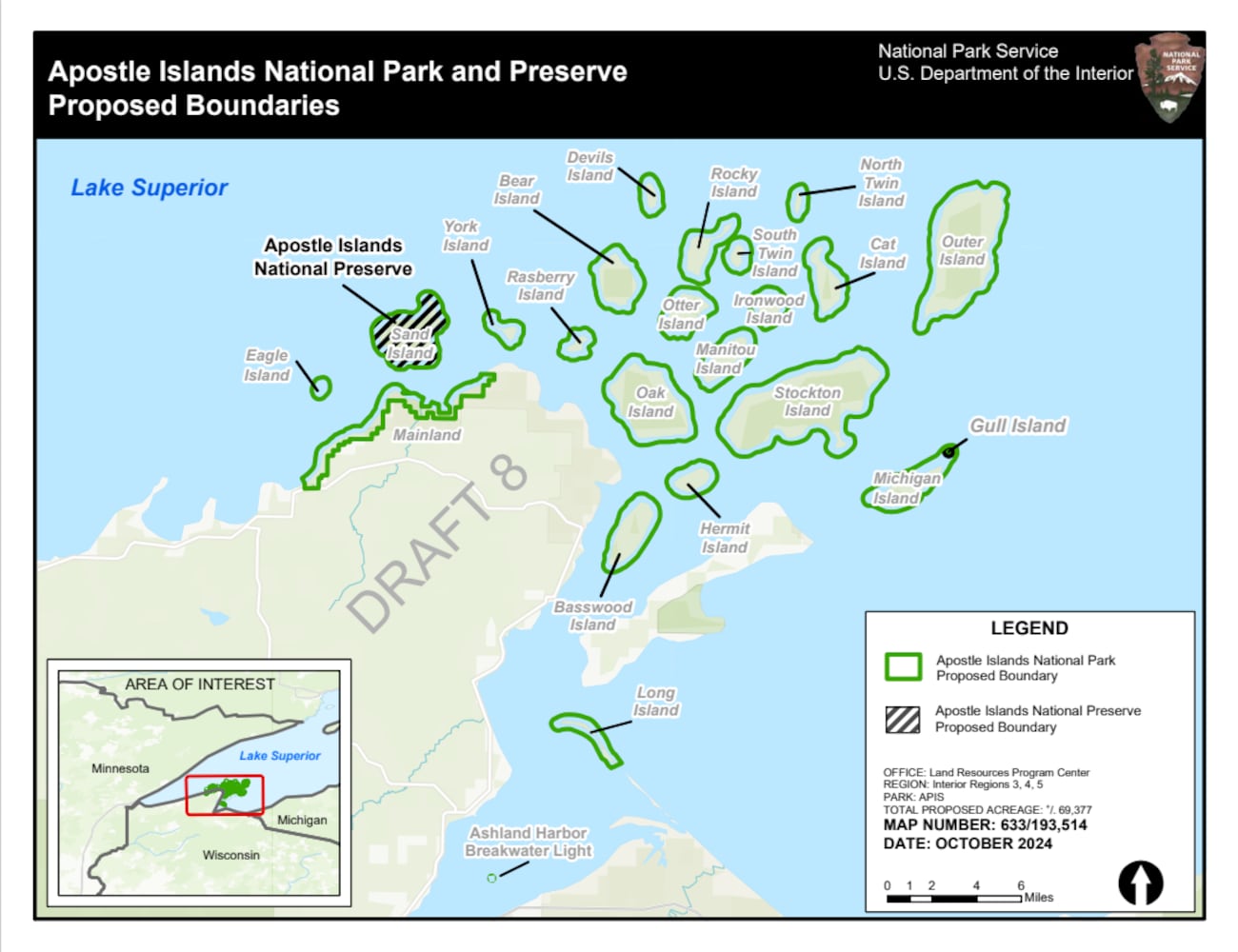 The Chequamegon area’s Apostle Islands National Lakeshore has been in the news lately due to the reintroduction of Congressman Tom Tiffany’s proposed Apostle Islands National Park and [Sand Island] Preserve Act. This proposed Act has been controversial due to strong opposition from local governments citing lack of consultation and insufficient infrastructure, among other concerns.
The goal of this post is to raise awareness about how the current Apostle Islands National Lakeshore contains roughly 3,000 acres of tribal lands reserved by the 1854 Treaty of La Pointe, and should consider returning these tribal lands back to the Lake Superior Chippewa before making any changes to become the proposed Apostle Islands National Park and Sand Island Preserve.
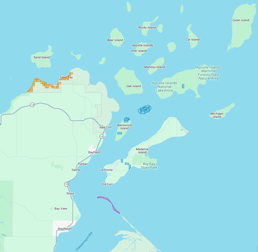
The current Apostle Islands National Lakeshore contains 3 types of lands reserved by the 1854 Chippewa Treaty of La Pointe:
29 Allotments (red) within the Red Cliff Reservation,
14 Allotments (blue) on Stockton, Hermit, & Basswood Islands,
and the disputed Bad River Reservation (purple) on Long Island.
All of the Apostle Islands are part of the ceded territory from the 1842 Treaty of La Pointe covering roughly 22,000 square miles in northern Wisconsin and Michigan. The historical context of this 1842 ceded territory was to allow Americans to move into copper-rich areas while still retaining hunting, fishing and gathering rights for the Lake Superior Chippewa on those same lands. In modern context, this 1842 ceded territory has natural resource managed jointly between the States of Michigan and Wisconsin, the Lake Superior Chippewa, and Great Lakes Indian Fish & Wildlife Commission (GLIFWC).
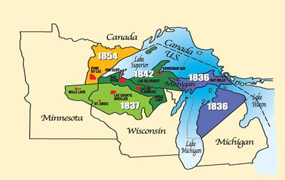
Map of 1836, 1837, 1842, and 1854 ceded territories jointly managed by the Great Lakes Indian Fish & Wildlife Commission (GLIFWC).
The 1854 Treaty of La Pointe reclaimed certain lands within the 1842 ceded territory to be reserved as permanent homelands for the Lake Superior Chippewa Bands in the form of Reservations and Allotments. For more information, we have covered the debates and circumstances leading up to the creation of these Reservations and Allotments in great detail on this blog, such as the Sandy Lake Tragedy and Ojibwe Removal events. Unfortunately much of those Reservations and Allotments have become “checkerboarded” or alienated from the Lake Superior Chippewa despite the original intention of being permanent homelands.
In this post we will examine roughly 3,000 acres of those Reservations and Allotments from the 1854 Treaty of La Pointe that are contained within the Apostle Islands National Lakeshore today. For clarification, there is a Reservation and several Allotments on Madeline Island, which are outside of the Apostle Islands National Lakeshore and will be discussed at a later date instead of in this post. Nor are we including any of the 1887 Dawes Act Allotments on the Apostle Islands in this post, because they are not from the 1854 Treaty.
Without further ado…
Zaagawaamikong-neyaashi
(roughly translated as “long soft beaver dam point”)
a.k.a. Chequamegon Point and Long Island
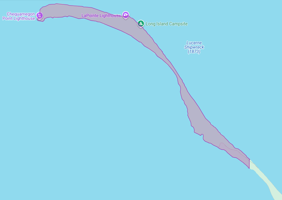
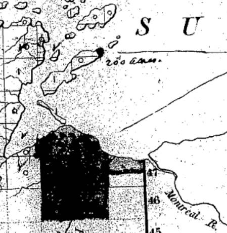
The Apostle Islands National Lakeshore contains Chequamegon Point (roughly 300 acres) on Long Island located at the Bad River Reservation (a.k.a. Mashkiiziibii).
Currently, federal maps of Long Island depict Chequamegon Point to lie outside the Bad River Reservation boundaries. Ownership of Chequamegon Point has been disputed between Bad River and the Federal Government for many generations since the 1854 Treaty.
This dispute is based on how the Second Clause of the Second Article of the 1854 Treaty of La Pointe defined the boundaries of the Bad River Reservation to follow “along the lake shore, crossing Shag-waw-me-quon [Chequamegon] Point, to the place of beginning“. In recent years, Bad River has been conducting a Historical Background Study about the 1854 Treaty of La Pointe and the Chippewa understanding of how they negotiated with Federal negotiators to include Chequamegon Point in Bad River’s lakeshore reservation boundaries.
We have mentioned this ongoing dispute in past posts, and will continue to examine historic records in support of Bad River’s efforts to repatriate tribal ownership of Chequamegon Point.
Gaa-giishkidaawangaa-wiikwedong
(roughly translated as “sand bay”)
a.k.a. Sand Point, Sand Bay, and Little Sand Bay
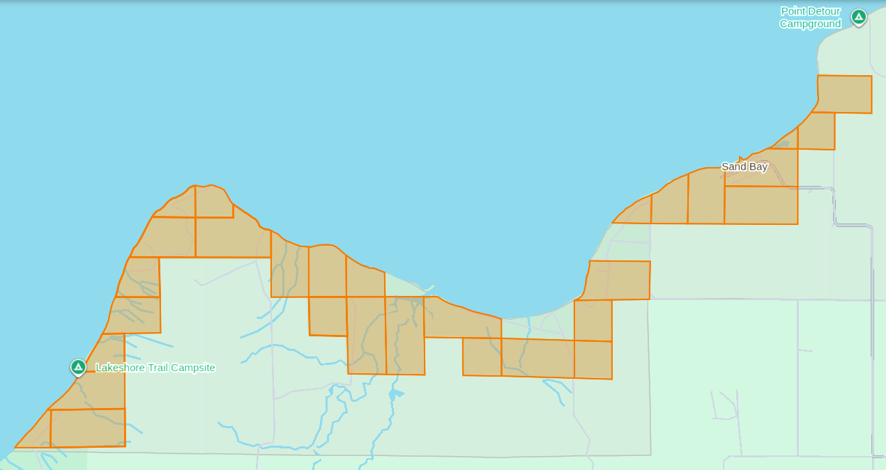
The Apostle Islands National Lakeshore’s Mainland Unit contains 29 Allotments (roughly 1,550 acres) located at the Red Cliff Reservation (a.k.a. Gaa-miskwaabikaang). The Sand Bay shoreline contains three Allotments (uncolored) that are owned by Red Cliff.
The media often cites the 1887 Dawes Act when describing how Allotments on the Lake Superior Chippewa Reservations became alienated from tribal ownership. That is factually incorrect, because these Allotments came from the 1854 Treaty of La Pointe, which precedes the 1887 Dawes Act by several decades. The key difference here is how these 1854 Chippewa Treaty Allotments were designed to reserve tribal land that would never be taken away later, while the later 1887 Dawes Act Allotments were designed to be alienated/sold after a period of 25 years. Unfortunately the 1854 Treaty Allotments were mismanaged by non-tribal governments as being temporary instead of permanent.
This mismanagement has caused much damage over time in the form of “checkerboarded” tribal land bases, which explains the legacy of how these 29 Allotments inside the Red Cliff Reservation fell out of tribal ownership and became part of the original boundaries of the Apostle Islands National Lakeshore.
In 1970, two additional Allotments along the Sand Bay shoreline were targeted to become part of the original boundaries of Apostle Islands National Lakeshore, but ultimately never became alienated from tribal ownership. Today these two Allotments still remain excluded from the boundaries of the current Apostle Islands National Lakeshore and proposed National Park.
In 2018, a third Allotment along Sand Bay that had fallen out of tribal ownership due to “checkerboarding” was repatriated from Town of Russell ownership back to tribal ownership, and is now a Tribal Management Unit of the Apostle Islands National Lakeshore.
The proposed boundaries of the Apostle Islands National Park and [Sand Island] Preserve Act contain this repatriated Allotment, but not the two Allotments that were never alienated from tribal ownership.
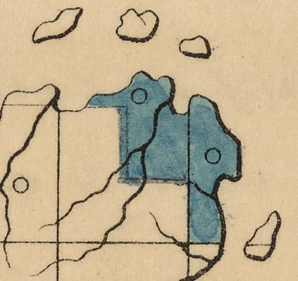
Wiisaakodewan-minis
(roughly translated as “half-burnt wood island”)
a.k.a. Stockton Island or Presque Isle
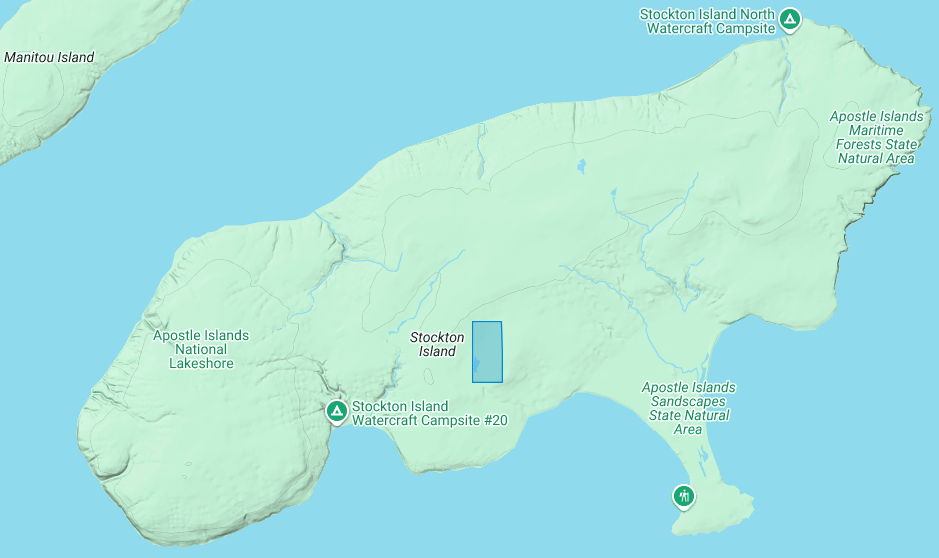
The Apostle Islands National Lakeshore contains one allotment (roughly 80 acres) on Stockton Island:
1) Joseph Gauthier (a.k.a. Gokee) Senior
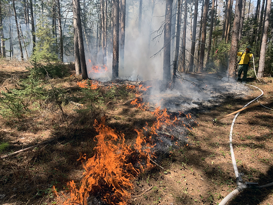
A prescribed fire on Stockton Island conducted by National Park Service and Tribal partners.
~ Photo by Dave Cooper at NPS
The root word of island’s traditional name, Wiisaakodewan (half-burnt wood), refers to Stockton Island’s historic appearance of being partially burnt. In recent years, the Apostle Islands National Lakeshore and the Lake Superior Chippewa have jointly reintroduced the practice of using prescribed fire management to promote the growth of blueberries and other traditional ecological resources on the cultural landscape of Stockton Island.
Wiisaakodewan also happens to be the root word of a pejorative slang term describing the Mixed Blood people of Lake Superior Chippewa. At the time of the Treaty Era, the Mixed Bloods of the Lake Superior Chippewa held a strong connection to this island via the tribal fishing industry. For example, the surveyor Joel Allen Barber described how “the bays on Presque Isle [Stockton Island] are a favorite resort of fishermen” in connection to the tribal fishing grounds of the La Pointe Indian Reservation on Madeline Island’s north end.
Wiigobiish-minis
(roughly translated as “basswood island”)
a.k.a. Basswood Island
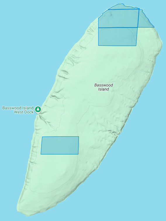
The Apostle Islands National Lakeshore contains four allotments (roughly 290 acres) on Basswood Island:
1) John Baptist Berriot
2) Henry Bresette (a.k.a. Brisette)
3) John Baptist Lemieux
4) Louis Neveaux
In a previous post we briefly mentioned that the infamous John Breckenridge made national news with his land speculation on Basswood Island immediately following the 1854 Treaty of La Pointe. In a few short years Breckinridge would become Vice President of the United States, and also a Confederate States Army brigadier general during the Civil War.
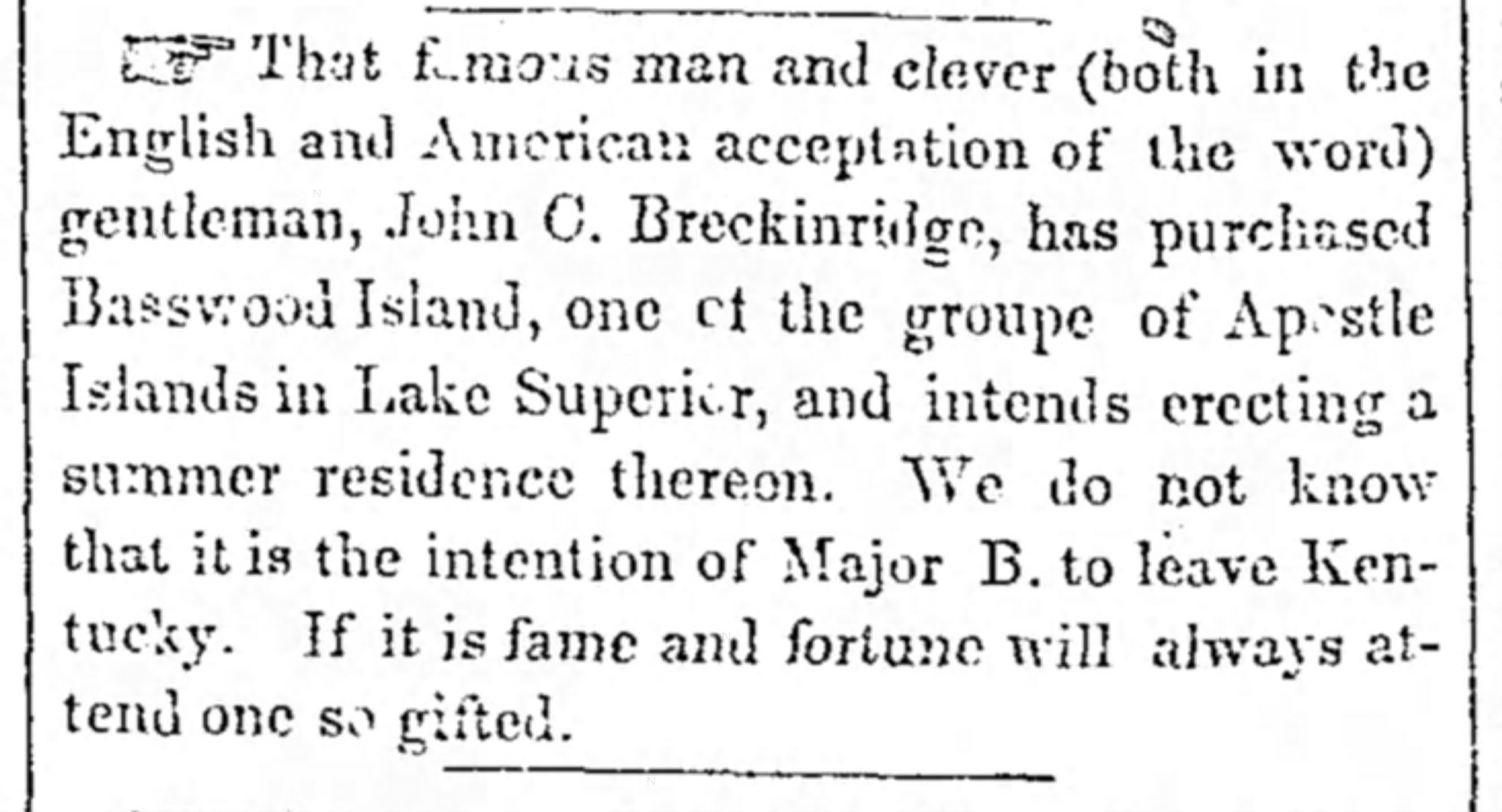
The Louisville Daily Courier [Kentucky], August 14th 1855, Page 4.
Eshkwegwindeg-minis
(roughly translated as “floating at the end or behind island”)
a.k.a. Hermit Island
f.k.a. Austrian Island
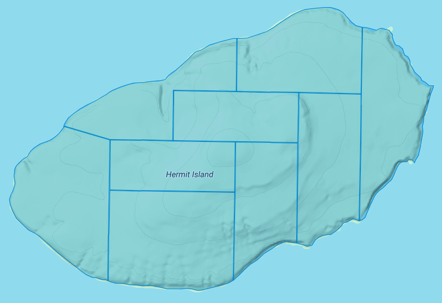
The Apostle Islands National Lakeshore contains nine allotments (roughly 780 acres) covering all of Hermit Island:
1) Josette Deefoe (a.k.a. Defoe)
2) Michael Defoe
3) Francois Dejadin (a.k.a. Artishon) Junior
4) Charles Dingley
5) Mary Dingley
6) Mary DuBay
7) Louis Gaudin (a.k.a. Gordon)
8) John Baptist Goslin (a.k.a. Gauslin)
9) Elizabeth (a.k.a. Isabella) Tremble
The traditional name of Eshkwegwindeg appears to be referencing this island’s location between the mainland and several other Apostle Islands. Today it still remains a central hub between the Red Cliff Reservation, the La Pointe Reservation on the north end of Madeline Island, and the other Apostle Islands with Allotments. It is noteworthy how the entirety of this Island is covered by Allotments, unlike the other aforementioned Islands.
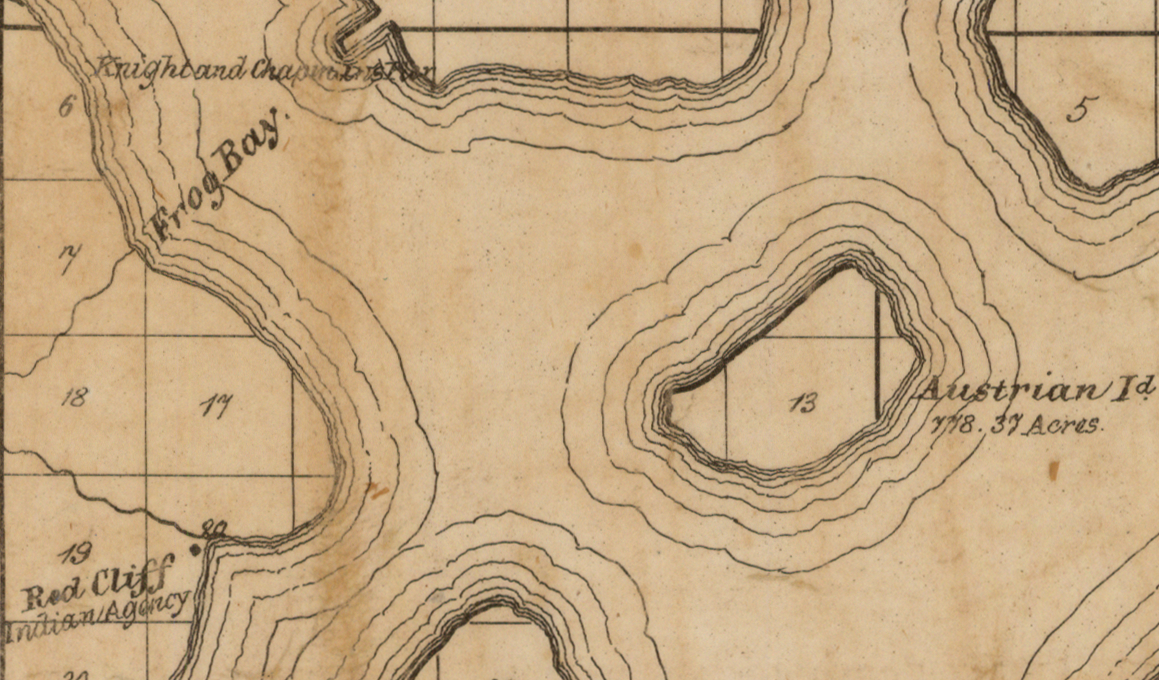
Austrian Island on Asaph Whittlesey’s 1871 map of Apostle Islands and Harbor of Bayfield and Its Surroundings.
~ Wisconsin Historical Society
Modern maps call this Hermit Island in reference to the colorful story of how William Wilson was ostracized from La Pointe and relocated to this Island to live out a solitary life during the Treaty Era. The famous “brownstone king” Frederick Prentice‘s connection to this Island in later decades is also a popular story being told by tour guides in modern times. However, I personally am more interested in exploring the history of how this Island was know as “Austrian Island” between the Wilson and Prentice eras, because it illustrates Julius Austrian’s abuse of Allotments to take private ownership of what should be tribal lands for personal profit.
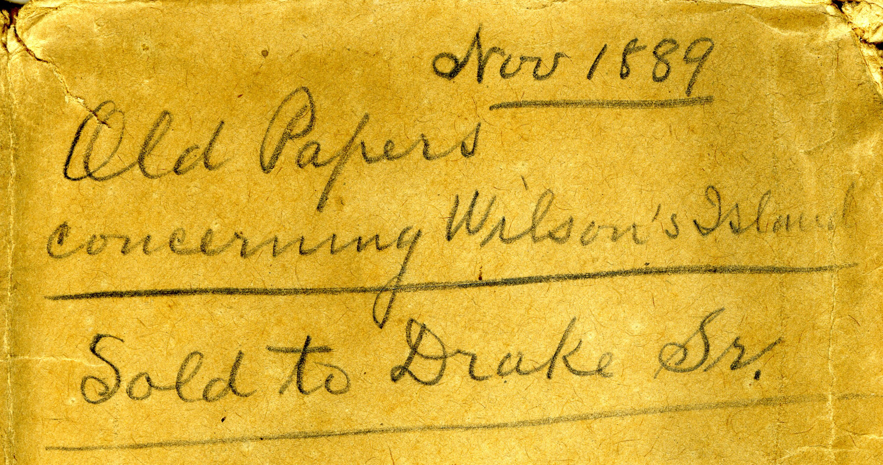
Madeline Island Museum
JULIUS AUSTRIAN PAPERS (2011.158.A) Folder 5:
PAPERS RELATING TO WILSON’S ISLAND (HERMIT ISLAND IN THE APOSTLE ISLANDS ARCHIPELAGO), WISCONSIN (1870-1888)
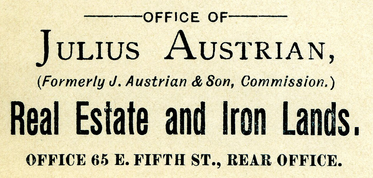
Julius Austrian’s corporate letterhead circa 1888 advertising Allotments for sale.
I personally became very interested in Chequamegon history specifically because of Julius Austrian and his abuse of Allotments to take private ownership of what should be tribal lands in the Penokee Mountains for personal profit, and how that legacy evolved to become what is still known as the La Pointe Iron Company today.
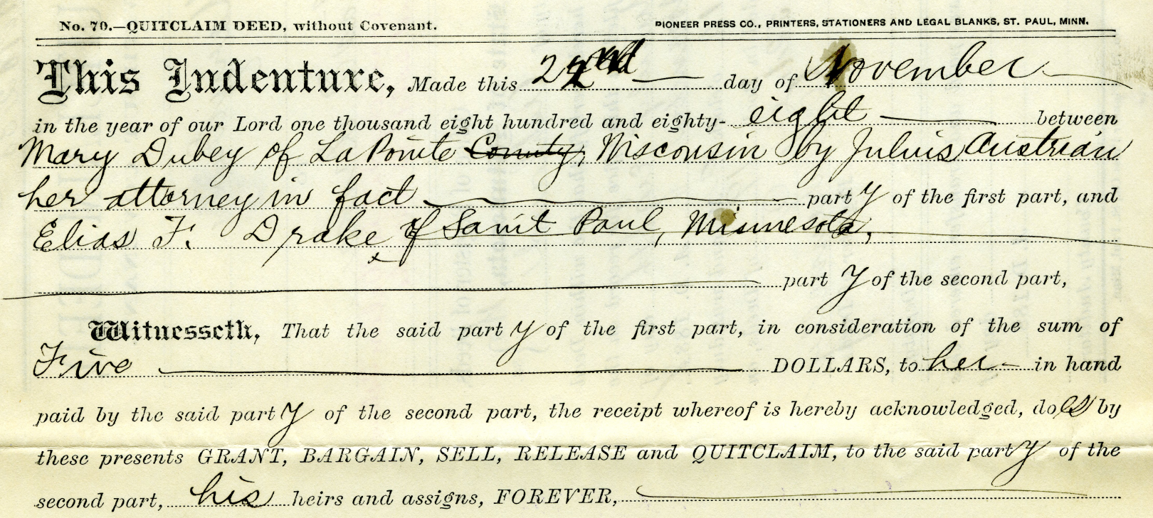
Example of Julius Austrian using Power Of Attorney to buy Mary DuBay’s Allotment for $5 so he could later flip it for profit as private property.
Austrian’s land speculation on Hermit Island follows the same trend of using Allotments via power of attorney over Mixed Blood tribal members of the Lake Superior Chippewa to grab ownership of prime real estate before other land speculators. In the Penokees example, Austrian gave each Mixed Blood $100 to sell their Allotments via Power of Attorney, but here we see how Austrian gave Mary DuBay only $5 for her Allotment on Hermit Island.
My research has been the foundation of academic research in Larry Nesper’s book Our Relations…the Mixed Bloods, and I will continue to post more on this topic in the Austrian Papers on this website.
So what?
Regular readers of Chequamegon History know that my writing style is to post historic documents enhanced with multimedia and sidebars, but omit my own interpretations and and just let readers reach their own conclusions. Leo, on the other hand, is more inclined to speak out about the implications, such as in his posts 19th Century Deer in the Headlights and Slavery, Debt Default, and the Sandy Lake Tragedy. However, in this case, due to Congressman Tom Tiffany’s ongoing efforts despite strong opposition from local governments, I felt it was important to expound on this issue a bit more than I usually do.
Righting a Wrong: Restoring Lands to the Leech Lake Band of Ojibwe
In 2020, the Leech Lake Band of Ojibwe Reservation Restoration Act (Public Law 116-255) returned approximately 11,760 acres of allotted lands wrongfully taken by the Chippewa National Forest back to Tribal ownership and management. The same concept should be applied to repatriate tribal lands in the Apostle Islands National Lakeshore before moving forward with the proposed Apostle Islands National Park and Preserve Act.
Lac Court Oreilles Band of Lake Superior Chippewa v. Walker, Evers
Tribes of the 1854 Chippewa Treaty in Michigan and Wisconsin have won two important lawsuits in recent years due to the fact that their tribal lands should have been reserved under the 1854 Treaty of La Pointe instead of becoming “checkerboarded” from illegal taxation/foreclosures.
Red Cliff Band of Lake Superior Chippewa Indians v. Bayfield County
What started off as a dispute about zoning authority over tribal lands has developed into a constructive partnership. Bayfield County and Red Cliff have developed a Memorandum of Understanding that has led to repatriation of tribal lands within the Red Cliff Reservation. This has led to 2,500 acres being returned by the County to Red Cliff in recent years, with the last 900 acres being completed in 2022.
While returning all County-owned surface rights within the Reservation back to the Tribe has been a tremendous achievement, the County still owns mineral rights within the Red Cliff Reservation. Mineral rights supersede land rights under Wisconsin law, so more work still remains to be done in these land repatriation efforts between Bayfield County and Red Cliff.
Bayfield County should promote their efforts in recent years to help Red Cliff repatriate 2,500 acres of County-owned lands back to tribal ownership, and encourage the Apostle Islands National Lakeshore to return their 3,000 acres of Reservation/Allotments back to tribal ownership.
Frog Bay Tribal National Park
Congressman Tom Tiffany claims that his proposed Apostle Islands National Park and Preserve Act would create the first National Park in Wisconsin. However, Red Cliff already earned that claim to fame in 2012 by establishing the Frog Bay Tribal National Park through an innovative partnership to repatriate Allotments on their Reservation from non-native landowners.
We would much rather see the establishment of a Sand Bay Tribal National Park in Red Cliff, a Chequamegon Point Tribal National Park in Bad River, and Tribal National Parks for the Apostle Islands Allotments, before the proposed Apostle Islands National Park and Preserve. Ultimately these Tribal Lands should be returned to the Lake Superior Chippewa and let them decide whether to manage them as Tribal National Parks or not.
The 1856 Reservation for Chief Buffalo’s Estate
November 5, 2025
Collected & edited by Amorin Mello
This is one of many posts on Chequamegon History exploring the original La Pointe Band Reservations of La Pointe County on Chequamegon Bay, now known as the Bad River and Red Cliff Reservations. Specifically, today’s post is about the 1856 Reservation for Chief Buffalo’s subdivision of the La Pointe Band and how it got selected in accordance with the Sixth Clause of the Second Article of the 1854 Treaty with the Chippewa at La Pointe:
1854 Treaty with the Chippewa at La Pointe
…

Map of La Pointe Band Reservations:
334 – Bad River Reservation
335 – La Pointe Fishing Reservation
341 – Chief Buffalo’s Reservation
342 – Red Cliff Reservation
18th Annual Report of the Bureau of American Ethnology to the Secretary of the Smithsonian Institution 1896-’97
Printed by U.S. Congress in 1899
ARTICLE 2. The United States agree to set apart and withhold from sale, for the use of the Chippewas of Lake Superior, the following-described tracts of land, viz:
…
6th [Clause]. The Ontonagon band and that subdivision of the La Pointe band of which Buffalo is chief, may each select, on or near the lake shore, four sections of land, under the direction of the President, the boundaries of which shall be defined hereafter. And being desirous to provide for some of his connections who have rendered his people important services, it is agreed that the chief Buffalo may select one section of land, at such place in the ceded territory as he may see fit, which shall be reserved for that purpose, and conveyed by the United States to such person or persons as he may direct.
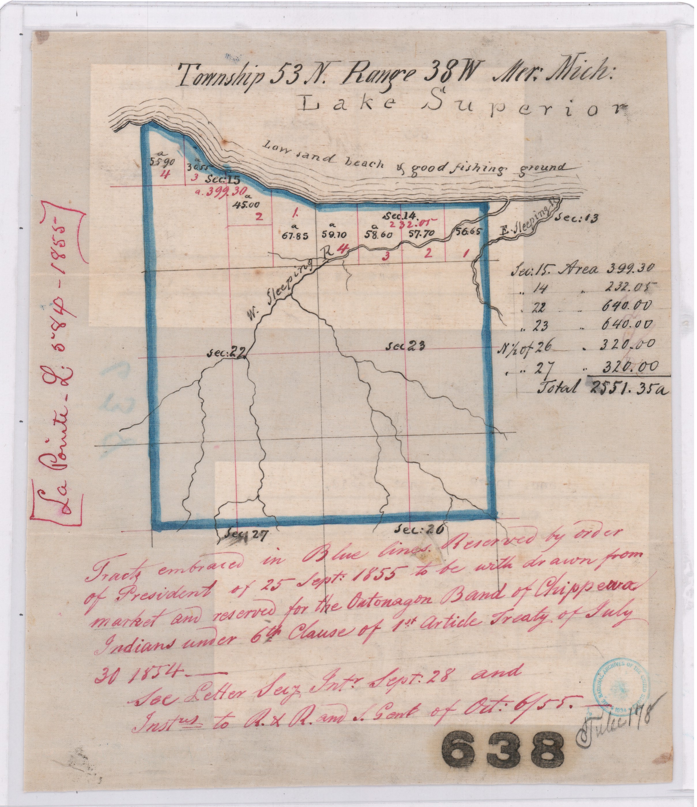
Map of “Tract embraced in blue lines reserved by order of President of 25 September 1855 to be withdrawn from market and reserved for the Ontonagon Band of Chippewa Indians“ on a “low sand beach & good fishing ground”.
Central Map File No. 638 (Tube No. 138)
NAID: 232923886 cites “La Pointe L.584-1855”.
The Ontonagon Band and Chief Buffalo’s Subdivision of the La Pointe Band got lumped together in this clause, so let’s review the Ontonagon Band first. Less than one year after the 1854 Treaty, the Ontonagon Band selected four square miles for their Reservation as approved by President Franklin Pierce’s Executive Order of September 25, 1855. Today the Ontonagon Band Reservation still has its original shape and size from 1855 despite heavy “checkerboarding” of its landownership over time.
In comparison to the Ontonagon Band Reservation, the history of how Chief Buffalo’s Reservation got selected is not so straightforward. Despite resisting and surviving the Sandy Lake Tragedy and Ojibwe Removal, making an epic trip to meet the President at Washington D.C., and securing Reservations as permanent homelands for the Chippewa Bands in the 1854 Treaty, Chief Buffalo of La Pointe died in 1855 before being able to select four square miles for his Subdivsion of the La Pointe Bands.
Fortunately, President Franklin Pierce’s Executive Order of February 21, 1856 withheld twenty-two square miles of land near the Apostle Islands from federal public land sales, allowing Chief Buffalo’s Estate to select four of those twenty-two square miles for their Reservation without competition from squatters and other land speculators, while other prime real estate in the ceded territory of La Pointe County was being surveyed and sold to private landowners by the United States General Land Office.
This 1856 Reservation of twenty-two square miles for Chief Buffalo’s Estate set the stage for what would eventually become the Red Cliff Reservation. We will return to this 1856 Reservation for Chief Buffalo’s Estate in several upcoming posts exploring more records about Red Cliff and the other La Pointe Band Reservations.

Maps marked “A” showing certain lands reserved by the 1854 Treaty:
Central Map File No. 793 (Tube 446)
NAID: 232924228 cites “La Pointe L.579-1855″.
Central Map File No. 816 (Tube 298)
NAIDs: 232924272 & 50926136 cites “Res. Chippewa L.516-1855”.

1878 Copy of President Franklin Pierce’s Executive Order of February 26, 1856 for Chief Buffalo’s Subdivision (aka “Red Cliff”).
NAID: 117092990
Office of Indian Affairs.
(Miscellaneous)
L.801.17.1878
Copy of Ex. Order of Feby. 21. 1856.
Chippewas (Red Cliff.)
Wisconsin.
Enc. in G.L.O. letter of Nov 23, 1878 (above file mark.)
in answer to office letter of Nov. 18, 1878.
Ex. Order File.

Secretary of the Interior
Robert McClelland
Department of the Interior
February 21, 1856
Sir,
I herewith return the diagram enclosed in your letter of the 20th inst, covering duplicates of documents which accompanied your letter of the 6th Sept. last, as well as a copy of the latter, the originals of which were submitted to the President in letter from the Department of the 8th Sept. last and cannot now be found.
You will find endorsements on said diagram explanatory of the case and an order of the President of this date for the withdrawal of the land in question for Indian purposes as recommended.
Respectfully
Your obt. Servt
R McClelland
Secretary
To
Hon Thos A Hendrick
Commissioner of the
General Land Office
(Copy)
General Land Office
September 6, 1855
Hon R. McClelland
Sec. of Interior
Sir:
Enclosed I have the honor to submit an abstract from the Acting Commissioner of Indian Affairs letter of the 5th instant, requesting the withdrawal of certain lands for the Chippewa Indians in Wisconsin, under the Treaty of September 30th, 1854, referred by the Department to this office on the 5th. instant, with orders to take immediate steps for the withdrawal of the lands from sale.
Detail of 1856 Reservation in pencil on “a map marked A.“
Central Map File No. 816 (Tube 298)
NAIDs: 232924272 & 50926136 cites “Res. Chippewa L.516-1855”.
In obedience to the above order I herewith enclose a map marked A. Showing by the blue shades thereon, the Townships and parts of Townships desired to be reserved, no portion of which are yet in market, to wit:
Township 51 N. of Range 3 West 4th Prin. Mer. Wis.
N.E. ¼ of Town 51 N ” 4 ” ” ” “.
Township 52 ” ” 3 & 4 ” ” ” “.
For the reservation of which, until the contemplated Selections under the 6th Clause of the Chippewa Treaty of 30th September 1854 can be made, I respectfully recommend that the order of the President may be obtained.
The requisite reports on the subject of the new surveys, and respecting preemption claims, referred to in the same order, will be prepared and communicated at an early day.
I am respectfully
Your Ob’t Serv’t
Thos. A. Hendricks
Commissioner
Department of the Interior
Feb. 20. 1856
Detail of 1856 Reservation in blue on “duplicate of the original“.
NAID: 117092990
This plat represents by the blue shade, certain land to be withdrawn with a view to a reservation, under Chippewa Treaty of 30 Sept 1854, and as more particularly described in Commissioner of the General Land Office in letter of 6th Sept 1855. The subject was referred to the President for his sanction of the recommendation made in Secretary’s letter of 8th Sept 1855 and the original papers cannot now be found. This is a duplicate of the original, received in letter of Comm’r of the General Land Office of this date and is recommended to the President for his sanction of the withdrawal desired.
R. McClelland
Secretary

1856 Reservation in red and modern Red Cliff in brown. Although different in shape, both are roughly twenty-two square miles in size.
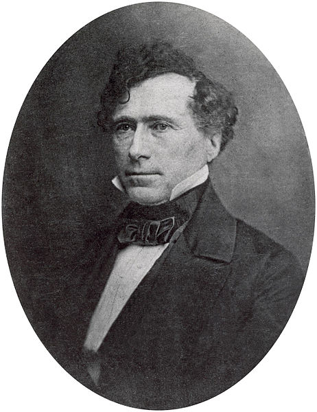
14th United States President
Franklin Pierce
February 21st 1856
Let the withdrawal be made as recommended.
Franklin Pierce
Indian Agency’s Instructions for the 1854 Treaty
September 26, 2020
Collected and edited by Amorin Mello
Indian Agency’s Instructions to
Henry C. Gilbert and David B. Herriman
for the 1854 Treaty at La Pointe
from Office of Indian Affairs federal archives
Department of the Interior
Office Indian Affairs
August 11, 1854

Indian Agent
Henry C. Gilbert
~ Branch County Photographs
Gilbert, Henry C.
Indian Agent
Detroit, Michigan
Sir:
The Bill to provide for the Extinguishment of the title of the Chippewas to the lands owned and claimed by them in Wisconsin and Minnesota, which passed the House early in the Sessions, failed in the Senate.
In view however of the importance of extinguishing the Indian title to portions of the Chippewa Country, it is deemed proper to confide to you certain conditional instructions, to the end that if in your judgement it be practicable to conclude a treaty at the period when you assemble the Indians to pay them their annuities this fall, that object may be accomplished.
You will therefore consider yourself in conjunction with Major Herriman as the Officers of the Indian Department designated to make a treaty with the Chippewa Indians of Lake Superior and the Mississippi.
~ Indian Agent Gilbert’s Explanation after the 1854 Treaty
When you arrive at La Pointe, if you are satisfied that you can send a runner over to the Mississippi & have Major Herriman come over immediately, with the principal Chief and three or four of the Headmen of each of the bands who receive pay at the Agency, and who reside on or near the Mississippi, or between that stream & the Lake, you will do so. The design is that the principal Chief and Head Men to the number stated of all the bands, other than those to be paid by you, be present on the Occasion. The latter will of course be represented.
I am informed that that the Mississippi Indians can be brought over in the way I suggest, as soon as you can assemble yours. If you are satisfied of this fact you are authorized to send over the runner, but it is not my wish that any attempt be made, and a failure follow.
If delegates from all the bands can be assembled and negotiations had with them, you are authorized to offer the Chippewas the sum of $500,000 for all the country they now own or claim in the territory of Minnesota, the state of Wisconsin or elsewhere excepting and reserving for the future home of said Indians a quantity of land equal to 743,000 acres which may be selected in one body or in two or three locations, as the Indians may desire, and if the reservations be selected in more than one locality, the quantity of land fixed upon, as the Maximum amount of the reserve must be divided between the different locations of the Indians according to the population of the bands who may elect to inhabit such reservation or reservations. If the Indians could all be placed on one reserve, so that an Agent could always have a perfect Oversight over them it would be much better for their future interests; but if this cannot be effected, the several sub-reserves should be located in such proximity to each other, as to enable the Agent to exercise a watchful care over the Indians.
The future home or reserves should not be in the avenues by which the white population will approach the ceded country, or embrace any of the mineral lands which are now becoming desirable.
I send herewith a copy of the instructions of the Secretary of War of the date of 4th of June 1847, when a former Commission attempted to treat with these Indians, but failed. According to the Estimates of this Office, the Chippewas own about 10,743,000 Acres of land, the greater part of which is of no value to them, and never will be. Some portions of it will be valuable to the White population.
Nevertheless, the condition of Affairs with the Chippewas is such that it is the duty of the Government to Offer them an Opportunity to dispose of their tenure to their Country, and in lieu thereof, to give them a small tract as a permanent home, with such means of support & neutral & moral improvement, as may be of great advantage to them.
I transmit herewith a copy of the bill alluded to and also a copy of a recent treaty with the Ottoe & Missouri Indians, remarking that if a provision is inserted for allowing individual reservations within the general reservations that Eighty Acres to the family, as provided in the bill is deemed ample. These documents may be useful as affording you indications of the views of the Department and of such provisions as it may be desirable to have incorporated in a treaty.
In view of the fact that it is necessary to enter upon this business without permitting those adverse influences, which are always at work to thwart the purposes, and objects of the Government, in its efforts to treat with the Indians, you will not divulge the nature of your instructions, or indeed say any thing about them to any person.

Julius Austrian
~ Madeline Island Museum
When you get to La Point, if you conclude to send for Maj. Herriman, and the principal Men of his bands, you can do so, leaving the impression on those who may be privy to it, that their presence is necessary, in order that a better understanding may exist as to a proper disposition of the present annuities between the Lake bands and those on the Mississippi.
Mr. Austrian who resides at La Point, and who was here last winter, tendered his services to the Office in collecting Indians etc. etc. at any time, and he is recommended to me as a faithful man. He would perhaps be a faithful man to whom to confide the message to Major Herriman.
I have caused a remittance, to be made to you, by requisition of this date for the sum of $1900 as follows:
Provisions for Indians $1500
Presents for 100 $300
Contingencies $100
$1900
which will be applicable to this object, but to be used only in case negotiations are had with the Chippewas. Except so far as the provisions & expenses of a runner may be necessary.
As far as these amounts are expended, to be accounted for under the proper heads of account.

George Washington Manypenny
~ Commons.Wikimedia.org
Very Respect’y Your Ob’t Servant
Geo. W. Manypenny
Commissioner
N.B. I learn that a boat leaves the Sault of St Marie on the 21st instant for Lapoint. If so you should avail yourself of the opportunity to go forward. The enclosed communication to Maj Herriman, you will forward to him by the runner, if you determine to send one, and be satisfied that the expedition will be successful before you send it states the whole matter to Major H. From the instructions to the Commissioners of June 4th 1847, and the Ottoe & Missouri treaty, you will form an idea of the necessary stipulations for the payment of the purchase money, the amount of it that should be invested etc. and the necessary provisions for Stock, Agricultural Implements etc. etc. in place of money. A map showing the country of the Chippewas is also herewith.
Geo. W. Manypenny
Commissioner
Department of the Interior
Office Indian Affairs
August 12th, 1854
Gilbert, H. C.
Indian Agent
Detroit, Michigan
Sir:
Referring to my letter of instruction to you of the 11th instant, I have to remark that should you succeed in having the proposed negotiations with the Chippewas, and a treaty be made, you will provide to pay the $500,000 as follows:
One hundred thousand dollars to be invested at five percent interest, which interest shall be expended annually under the President’s direction for purposes of Education, and the moral improvement of the Indians. The residue to be paid say in twenty annual installments of twenty thousand dollars each without interest, or these deferred payments may be extended over twenty five or thirty years, all of them however to be subject to the President’s discretion, as in Article 4 of the Ottoe & Missouri treaty.
If necessary to accomplish the object, although $500,000 is deemed the value of the Chippewa tenure to the land, you may go as high as $600,000 payments as above.
Should a treaty be made, it is submitted whether the new locations reserved & to the Indians, may not be of such a character as to render some of the smiths, farmers etc. stipulated for under former treaties of no use, and if so, that provisions be inserted cancelling such of these provisions, under former treaties, as can be dispensed with, and providing that a sum equal to the amount, now paid annually for such, may be appropriated for the unexpired term of former treaty stipulations to be expended by the President, for the use of the Indians, as other funds are provided to be expended.
Very Respectfully
Your Ob’t Servant
Geo. W. Manypenny
Commissioner
Department of the Interior
Office Indian Affairs
August 14, 1854
Gilbert, H. C.
Indian Agent
Detroit, Michigan
Sir:
~ Indian Agent Gilbert’s Explanation after the 1854 Treaty
Referring to my letters of instruction of the 11th & 12th instant, both of which were prepared in great haste, I am inclined to the opinion that a state of things may exist that you might feel embarrassed at the suggestions that if the land reserved by the Indians was located in more than one tract the several sub-reserves should be in such close proximity as to enable the agent to have a constant oversight over all the Indians. It may however occur that there may be partialities and predilections among the different bands for different and widely separated districts, and that these partialities cannot be overcome. I am clearly of the opinion that all the land reserved should be in one body and every reasonable effort should be employed to impress the Indians with this view; and if it fail the fewest sub-reserves that can be got along with should be allowed and if possible they should be in the same region of Country; but if the Indians have the predilections alluded to, and they cannot be changed in their views, you will accede to their wishes to a reasonable extent in this particular. And if it should so happen that they select locations widely distant from each other so that it would be more for their interests that one portion might be under one Agent and another under another, it would be well perhaps to adjust all matters between the bands thus located, naming all of them by bands which select a reservation. Setting apart according to the population their portion of such reserved land, and providing to pay them by the same rule, their proportion of the purchase money at their reserve, and so with the bands on each of the reserves. And indeed a clause might be inserted, adjusting and dividing by population to the Indians of each reserve the annuities to become due under former treaties, whether of money or in kind so that no difficulties could hereafter arise provided one part should be in one agency and others in another.
Several members of the Indian Committee of the Senate having expressed a wish that a clause or article of the following import should be inserted in all treaties hereafter made. You will please put it in the treaty which I hope you may be able to enter into with the Chippewas. It is thus:
“The United States agree that an examination shall be made, and all sums that may be found equitably due to the Indians, for arrearages of annuity or other thing, under the provisions of former treaties, shall be paid as the chiefs may direct.”
And; It is agreed between the United States and the said Chippewa Indians, that should it at any time hereafter be considered necessary, and for the benefit of said Indians, it shall be discretionary with the President by & with the advise and consent of the Senate to change the annuities herein provided for or any part thereof into a fund establishing farms among and for them.
Very Respectfully
Your Ob’t Servant
Geo. W. Manypenny
Commissioner
Indian Agency’s Explanation of the 1854 Treaty
December 13, 2017
By Amorin Mello
Treaty Commissioner Henry C. Gilbert’s
Explanation of the Treaty Concluded in 1854
with the Assistance of David B. Herriman
Transactions of the Wisconsin Academy of Sciences, Arts and Letters:
Volume 79, No. 1, Appendix 5
Office Michigan Indian Agency
Detroit October 17th, 1854
Sir
Mackinac Indian Agent
Henry Clark Gilbert
~ Branch County Photographs
I transmit herewith a treaty concluded at LaPointe on the 30th Ultimo between Mr. Herriman and myself as Commissioners on the part of the United States and the Chippewas of Lake Superior and the Mississippi.
On receiving your letters of August 10th, 12th, and 14th, relative to this treaty, I immediately dispatched a special messenger from this place by way of Chicago, Galena and St. Paul to Mr. Herriman at the Crow wing Chippewa Agency transmitting to him your letter requesting him to meet me at LaPointe with the Chiefs and Headmen of his Agency at as early a day as possible. I adopted this course in preference to sending a messenger from La Pointe on my arrival there for the purpose of saving time and I was thus enabled to secure the attendance of Mr Herriman and the Mississippi Chiefs some 10 or 12 days earlier than I could otherwise have done.
I left for LaPointe on the 26th of August last and arrived there the 1st day of September – Mr Herriman meeting me there the 14th of the same Month.
By this time a large number of Indians had assembled – including not only those entitled to payment but all those from the Interior who live about Lakes de Flambeau and Lake Courteilles. The Chiefs who were notified to attend brought with them in every instance their entire bands. We made a careful estimate of the number present and found there were about 4,000. They all had to be fed and taken care of, thus adding greatly to the expenses attending the negotiations.

Charles William Wulff Borup and Charles Henry Oakes married into the La Pointe mixed blood Beaulieu family; built the American Fur Company’s new La Pointe outfit during the 1830’s; sold La Pointe to Julius Austrian during 1853; and started the first bank in Minnesota during 1854 at St. Paul.
~ 1854 banknote from HeritageAuctions.com
A great number of traders and claim agents were also present as well as some of the persons from St. Paul’s who I had reason to believe attended for the purpose of preventing if possible the consummation of the treaty. The utmost precautions were taken by me to prevent a knowledge of the fact that negotiations were to take place from being public. The Messenger sent by me to Mr Herriman was not only trust worthy but was himself totally ignorant of the purport of the dispatches to Major Herriman. Information however of the fact was communicated from some source and the persons present in consequence greatly embarrassed our proceedings.
After Major Herriman’s arrival we soon found that the Mississippi Indians could not be induced to sell their land on any terms. Much jealousy and ill feeling existed between them and the Lake Superior Indians and they could not even be prevailed upon to meet each other in council. They were all however anxious that a division should be made of the payments to become due under former existing treaties and a specific apportionment made between the Mississippi and the Lake Superior Indians and places of payment designated.
Taking advantage of this feeling we proposed to them a division of the country between them and the establishment of a boundary line, on one side of which the country should belong exclusively to the Lake Superior and on the other side to the Mississippi Indians. We had but little difficulty in inducing them to agree to this proposition and after much negotiation the line designated in the treaty was agreed upon.
We then obtained from the Lake Indians a cession of their portion of the Country on the terms stated in the treaty. The district ceded embraces all the mineral region bordering on Lake Superior and Pigeon river & is supposed to be by far the most valuable portion of their country. But a small portion of the amount agreed to be paid in annuities is payable in coin. The manner of payment is such as in our judgement would most tend to promote the permanent welfare and hasten the civilization of the Indians.
We found the points most strenuously insisted upon by them were first the privilege of remaining in the country where they reside and next the appropriation of land for their future homes. Without yielding these points, it was idle for us to talk about a treaty. We therefore agreed to the selection of lands for them in territory heretofore ceded.
The tract for the Ance and Vieux Desert bands is a the head of Ke, wa, we naw Bay Michigan and is at present occupied by them. I estimate the quantity at about 60,000 acres.
Detail of La Pointe Indian Reservation survey boundaries including Gichi-ziibiiwishenhnyan from a letter dated March 30th, 1855, written by the Commissioner John Wilson of the General Land Office to General Surveyor Warner Lewis.
~ National Archives Microfilm Publications; Microcopy No. 27; Roll 16; Volume 16.
These reservations are located in Wisconsin, the principal of which is for the LaPointe Band on Bad river – A large number of Indians now reside there and I presume it will ultimately become the home of most of the Chippewas residing in that state. It is a tract of land well adapted for Agricultural purposes and includes the present Missionary Station under the care of the American Board of Commissioners for Foreign Missions. About one third of the land however lying on the Lake Superior is swamp and valueless, except as it gives them access to the Lake for fishing purposes.
The other Wisconsin reservations lie on Lac de Flambeau and Lac Courteirelle in the Interior and the whole amount of land reserved in that state I estimate at about 200,000 acres exclusive of the Swamp land included in the LaPointe reservation. in the ceded Country there are two tracts set apart for the Indians – one on St Louis river of 100,000 acres for the Fond DuLac bands and one embracing the point bounded by the Lake and Pigeon river and containing about 120,000 acres.
There are two or three other small reservations to be hereafter selected under the direction of the President. The whole quantity of land embrace within all the tracts set apart we estimate at about 486,000 acres – No portion of the reserved lands are occupied by whites except the Missionary establishment on Bad river.
The provision going to each Half Breed family 80 acres of land was most strenuously insisted upon by the Indians. There are about 200 such families on my pay roll and allowing as many more to the Interior Indians which is a very liberal estimate, the amount of land required will be about 32,000 acres.
A principal source of embarrassment was the provision setting aside a portion of the consideration to be paid as the Chiefs might direct &c. In other words to pay their debts with. We had much difficulty in reducing the amount insisted upon to the sum stated in the treaty. I have no doubt that there are many just claims upon these Indians. The regular payment of their annuities was so long withheld that they were forced to depend to a great extent upon their traders. There claims that were all disposed to acknowledge and insisted upon providing for their payment and without the insertion of the provision referred to, we could not have concluded the treaty.
I regret very much that we could not have purchased the whole country and made the treaty in every particular within the limit of your instructions. But this was absolutely impossible and we were forced to the alternative of abandoning the attempt to treaty or of making the concessions detailed in the treaty.
Bureau of Indian Affairs Director
George W. Manypenny
~ Commons.Wikimedia.org
There are many points respecting which I should like much to make explanations, and for that purpose and in order to make a satisfactory settlement of the accounts for treaty purposes and in order to make a satisfactory settlement of the accounts for treaty expenses I respectfully request the privilege of attending at Washington at such time after making my other annuity payments as you may think proper.
Very Respectfully
Your Obt. Servt.
Henry C. Gilbert
Commissioner
Hon. Geo. W. Manypenny
Com. Ind. Affs.
Washington D.C.
1854 Treaty of La Pointe Appropriations
November 29, 2017
By Amorin Mello

House Documents, Volume 112
By United States House of Representatives
33d Congress,
2nd Session.
Ex. Doc. No. 61.
TREATY WITH CHIPPEWA INDIANS.
————————
MESSAGE
FROM
THE PRESIDENT OF THE UNITED STATES,
United States President
Franklin Pierce
circa 1855
~ Commons.Wikimedia.com
TRANSMITTING
Estimates of appropriations for carrying into effect the treaty with the Chippewa Indians &c.
————————
February 8, 1855.—Laid upon the table and ordered to be printed.
————————
To the Senate and House of Representatives of the United States:
I communicate to Congress the following letter from the Secretary of the Interior, with its enclosure, on the subject of a treaty between the United States and the Chippewa Indians of Lake Superior, and recommend that the appropriations therein asked for may be made.
FRANLIN PEIRCE.
Washington, February 7, 1855.
Department Of The Interior,
Washington, February 6,1855.
Secretary of the Interior
Robert McClelland
circa 1916
~ Commons.Wikipedia.com
SIR: I have the honor to transmit to you, herewith, a copy of a communication from the Commissioner of Indian Affairs, dated the 5th instant, calling my attention to the subject of a treaty made at La Pointe, Wisconsin, by Henry C. Gilbert and Daniel B. Herriman, commissioners on the part of the United States, and the Chippewa Indians of Lake Superior; and, to enable this department to carry the treaty into effect, recommend that Congress be requested to make the appropriations specified in the letter of the Commissioner, and which will be immediately required for that purpose.
I am, sir, very respectfully, your obedient servant,
R. McCLELLAND,
Secretary.
To the President.
Department Of The Interior,
Office Indian Affairs, February 5, 1855.
Mackinac Indian Agent
Henry Clark Gilbert
~ Branch County Photographs
Sir: Having received the official information on the 24th ultimo of the approval and ratification, by the President and Senate, of the articles of agreement and convention made and entered into at La Pointe, in the State of Wisconsin, by Henry C. Gilbert and Daniel B. Herriman, commissioners on the part of the United States, and the Chippewa Indians of Lake Superior and Mississippi, I have the honor now to call your attention to the appropriations that will be required immediately to enable the department to carry the treaty into effect, viz:
For fulfilling treaties with the Chippewas of Lake Superior.
- For expenses (in part) of selecting reservations, and surveying and marking the boundaries thereof, per 2d, 3d, and 12th articles of the treaty of September 30, 1854 …….. $3,000
- For the payment of the first of twenty instalments in coin, goods, &c, agricultural implements, &c, and education, &c, per 4th article of the treaty of September 30, 1854 …….. 19,000
- For the purchase of clothing and other articles to be given to the young men at the next annuity payment, as per 4th article of the treaty of September 30, 1854 …….. 4,800
- For the purchase of agricultural implements and other articles, as presents for the mixed bloods, per 4th article of the treaty of September 30, 1854 …….. 6,000
- For the payment of such debts as may be directed by the chiefs in open council, and found to be just and correct by the Secretary of the Interior, per 4th article of the treaty of September 30, 1854 …….. 90,000
- For the payment of such debts of the Bois Forte bands as may be directed by their chiefs, and found lo be just and correct by the Secretary of the Interior, per 12th article of the treaty of September 30, 1844 …….. 10,000
- For the payment of the first of five instalments in blankets, cloth, &c, to the Bois Forte band, per 12th article of the treaty of September 30, 1854 …….. 2,000
- For the first of twenty instalments for the pay of six smiths and assistants, per 5th and 2d articles of the treaty of September 30, 1854 …….. 5,040
- For the first of twenty instalments for the support of six smith shops, per 5th and 2d articles of the treaty of September 30, 1854 …….. 1,320
It will be observed that the treaty of September 30, 1854, recognized the Chippewas of Lake Superior as a branch of the nation, and that the pecuniary and beneficiary stipulations therein are for their exclusive use.
By the fifth article of the treaty the Lake Superior Chippewas are to have six blacksmiths and assistants, and they relinquish, by the same article, all other employés to which they might otherwise have been entitled under former treaties.
The Chippewas of the Mississippi are, by the eighth article of the treaty, entitled to one-third of the benefits of treaties prior to 1847; and, by consequence, retain an interest of one-third in the stipulations for smith shops, &c., and farmers, &c, per second article of the treaty of July 29, 1837; and in the farmers, and carpenters, and smiths, &c., mentioned in the fourth article of the treaty of October 4, 1842.
On an examination of the condition of existing appropriations to fulfil the stipulations just mentioned, it is found that the balances in the treasury are sufficient to sustain these employés and otherwise meet the requirements of the stipulations referred to, so far as the Chippewas of the Mississippi are interested, during the next fiscal year.
In case appropriations are made by Congress, in pursuance of the foregoing estimates, it will be perceived that the following items of the Indian appropriation bill now before Congress might, with propriety, be stricken out, viz:
House bill 555, reported, with amendments, January 16, 1855:
- Page 4, lines 68, 69, 70, and 71, “three thousand dollars,” ($3,000.)
- Page 4, lines 72, 73, 74, 75, and 76, “one thousand dollars,” ($1,000.)
- Page 5, lines 89, 90, 91, 92, and 93, “two thousand dollars,” ($2,000.)
- Page 5, lines 94, 95, and 96, “one thousand dollars,” ($1,000.) Page 5, lines 97, 98, and 99, “one thousand two hundred dollars,” ($1,200.)
Director of of the Bureau of Indian Affairs
George Washington Manypenny
circa 1886
~ Commons.Wikimedia.org
As it is not deemed necessary, I do not therefore submit, at present an estimate for appropriations to pay employés for the Bois Forte band, as per twelfth article of the treaty of September 30, 1854, or to liquidate a balance, should any be found due to these Indians by the investigation, which it is provided by the ninth article of the same treaty shall be made.
Should the foregoing estimates and suggestions be approved by you, I respectfully recommend that they be laid before Congress as early as practicable.
Very respectfully, your obedient servant,
GEO. W. MANYPENNY,
Commissioner.
Hon. R. McCLELLAND,
Secretary of the Interior.
