1854 Treaty Lands at Apostle Islands National Lakeshore
March 20, 2026
Collected & edited by Amorin Mello
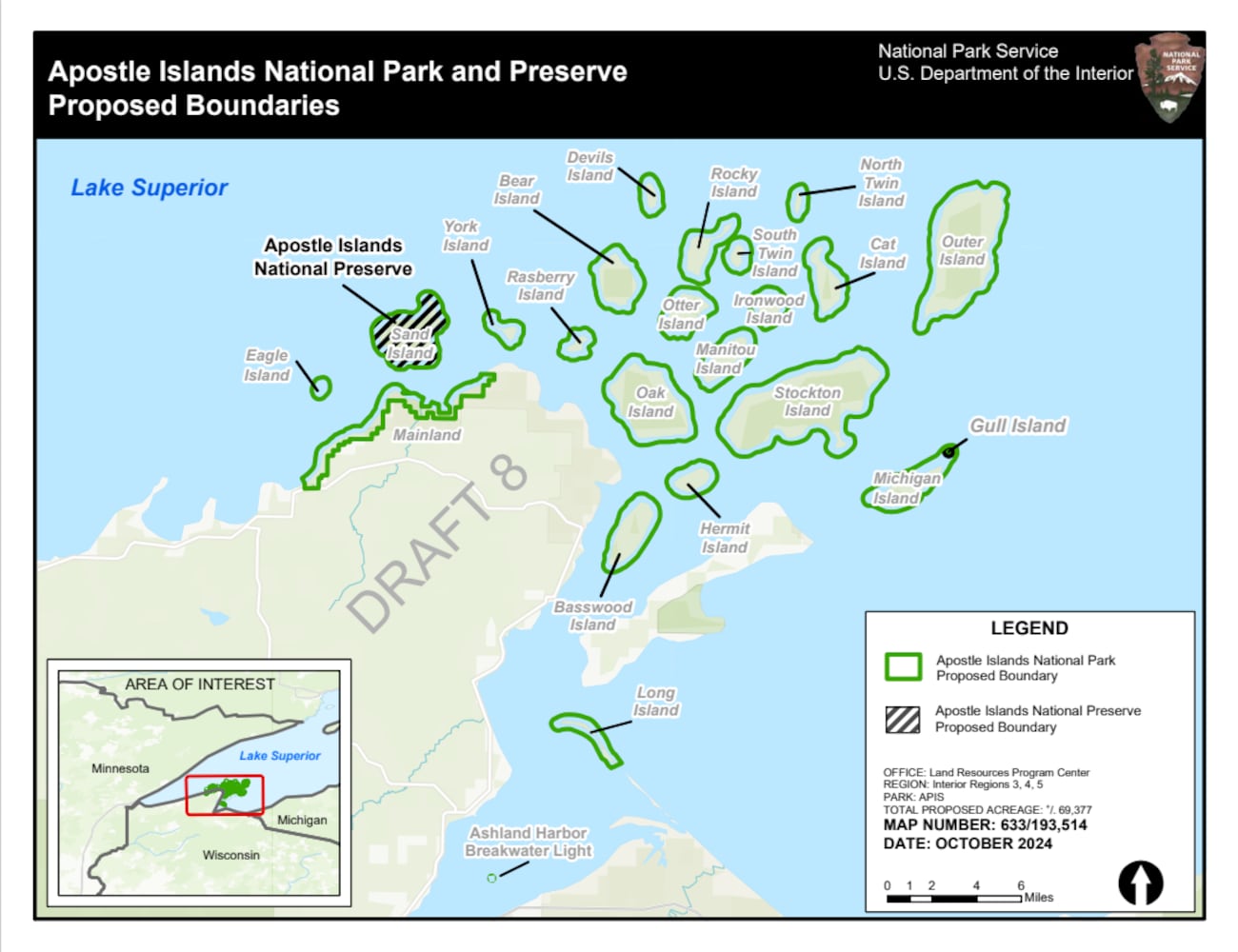 The Chequamegon area’s Apostle Islands National Lakeshore has been in the news lately due to the reintroduction of Congressman Tom Tiffany’s proposed Apostle Islands National Park and [Sand Island] Preserve Act. This proposed Act has been controversial due to strong opposition from local governments citing lack of consultation and insufficient infrastructure, among other concerns.
The goal of this post is to raise awareness about how the current Apostle Islands National Lakeshore contains roughly 3,000 acres of tribal lands reserved by the 1854 Treaty of La Pointe, and should consider returning these tribal lands back to the Lake Superior Chippewa before making any changes to become the proposed Apostle Islands National Park and Sand Island Preserve.
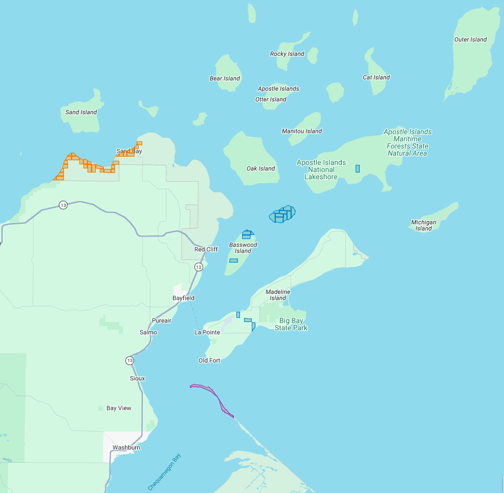
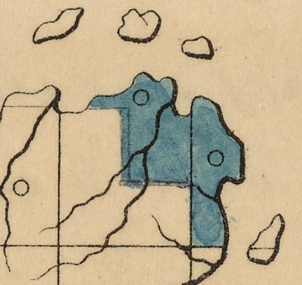
The current Apostle Islands National Lakeshore contains 3 types of lands reserved by the 1854 Chippewa Treaty of La Pointe:
29 Allotments (red) within the Red Cliff Reservation,
14 Allotments (blue) on Stockton, Hermit, & Basswood Islands,
and the disputed Bad River Reservation (purple) on Long Island.
All of the Apostle Islands are part of the ceded territory from the 1842 Treaty of La Pointe covering roughly 22,000 square miles in northern Wisconsin and Michigan. The historical context of this 1842 ceded territory was to allow Americans to move into copper-rich areas while still retaining hunting, fishing and gathering rights for the Lake Superior Chippewa on those same lands. In modern context, this 1842 ceded territory has natural resource managed jointly between the States of Michigan and Wisconsin, the Lake Superior Chippewa, and Great Lakes Indian Fish & Wildlife Commission (GLIFWC).
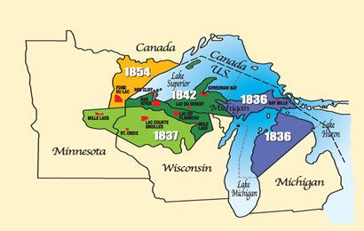
Map of 1836, 1837, 1842, and 1854 ceded territories jointly managed by the Great Lakes Indian Fish & Wildlife Commission (GLIFWC).
The 1854 Treaty of La Pointe reclaimed certain lands within the 1842 ceded territory to be reserved as permanent homelands for the Lake Superior Chippewa Bands in the form of Reservations and Allotments. For more information, we have covered the debates and circumstances leading up to the creation of these Reservations and Allotments in great detail on this blog, such as the Sandy Lake Tragedy and Ojibwe Removal events. Unfortunately much of those Reservations and Allotments have become “checkerboarded” or alienated from the Lake Superior Chippewa despite the original intention of being permanent homelands.
In this post we will examine roughly 3,000 acres of those Reservations and Allotments from the 1854 Treaty of La Pointe that are contained within the Apostle Islands National Lakeshore today. For clarification, there is a Reservation and several Allotments on Madeline Island, which are outside of the Apostle Islands National Lakeshore and will be discussed at a later date instead of in this post. Nor are we including any of the 1887 Dawes Act Allotments on the Apostle Islands in this post, because they are not from the 1854 Treaty.
Without further ado…
Zaagawaamikong-neyaashi
(roughly translated as “long soft beaver dam point”)
a.k.a. Chequamegon Point and Long Island
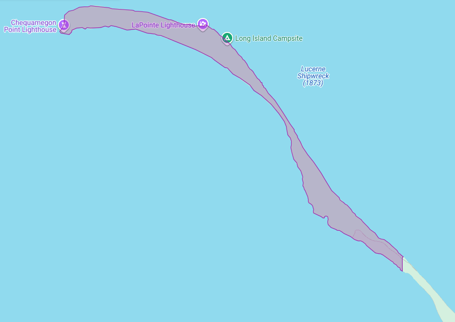
The Apostle Islands National Lakeshore contains Chequamegon Point (roughly 300 acres) on Long Island located at the Bad River Reservation (a.k.a. Mashkiiziibii).
Currently, federal maps of Long Island depict Chequamegon Point to lie outside the Bad River Reservation boundaries. Ownership of Chequamegon Point has been disputed between Bad River and the Federal Government for many generations since the 1854 Treaty.
This dispute is based on how the Second Clause of the Second Article of the 1854 Treaty of La Pointe defined the boundaries of the Bad River Reservation to follow “along the lake shore, crossing Shag-waw-me-quon [Chequamegon] Point, to the place of beginning“. In recent years, Bad River has been conducting a Historical Background Study about the 1854 Treaty of La Pointe and the Chippewa understanding of how they negotiated with Federal negotiators to include Chequamegon Point in Bad River’s lakeshore reservation boundaries.
We have mentioned this ongoing dispute in past posts, and will continue to examine historic records in support of Bad River’s efforts to repatriate tribal ownership of Chequamegon Point.
Gaa-giishkidaawangaa-wiikwedong
(roughly translated as “sand bay”)
a.k.a. Sand Point, Sand Bay, and Little Sand Bay
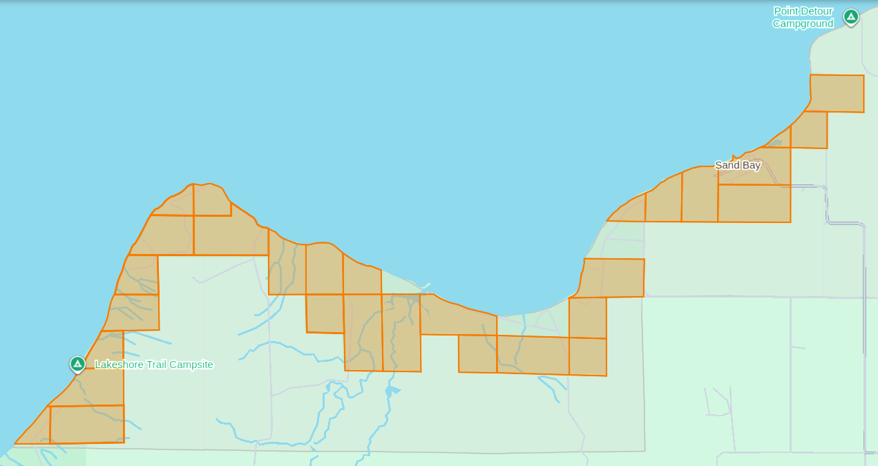
The Apostle Islands National Lakeshore’s Mainland Unit contains 29 Allotments (roughly 1,550 acres) located at the Red Cliff Reservation (a.k.a. Gaa-miskwaabikaang). The Sand Bay shoreline contains three Allotments (uncolored) that are owned by Red Cliff.
The media often cites the 1887 Dawes Act when describing how Allotments on the Lake Superior Chippewa Reservations became alienated from tribal ownership. That is factually incorrect, because these Allotments came from the 1854 Treaty of La Pointe, which precedes the 1887 Dawes Act by several decades. The key difference here is how these 1854 Chippewa Treaty Allotments were designed to reserve tribal land that would never be taken away later, while the later 1887 Dawes Act Allotments were designed to be alienated/sold after a period of 25 years. Unfortunately the 1854 Treaty Allotments were mismanaged by non-tribal governments as being temporary instead of permanent.
This mismanagement has caused much damage over time in the form of “checkerboarded” tribal land bases, which explains the legacy of how these 29 Allotments inside the Red Cliff Reservation fell out of tribal ownership and became part of the original boundaries of the Apostle Islands National Lakeshore.
In 1970, two additional Allotments along the Sand Bay shoreline were targeted to become part of the original boundaries of Apostle Islands National Lakeshore, but ultimately never became alienated from tribal ownership. Today these two Allotments still remain excluded from the boundaries of the current Apostle Islands National Lakeshore and proposed National Park.
In 2018, a third Allotment along Sand Bay that had fallen out of tribal ownership due to “checkerboarding” was repatriated from Town of Russell ownership back to tribal ownership, and is now a Tribal Management Unit of the Apostle Islands National Lakeshore.
The proposed boundaries of the Apostle Islands National Park and [Sand Island] Preserve Act contain this repatriated Allotment, but not the two Allotments that were never alienated from tribal ownership.
Wiisaakodewan-minis
(roughly translated as “half-burnt wood island”)
a.k.a. Stockton Island or Presque Isle
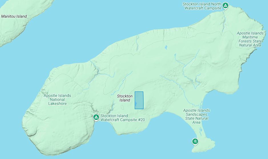
The Apostle Islands National Lakeshore contains one allotment (roughly 80 acres) on Stockton Island:
1) Joseph Gauthier (a.k.a. Gokee) Senior
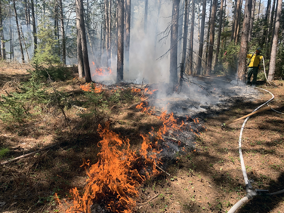
A prescribed fire on Stockton Island conducted by National Park Service and Tribal partners.
~ Photo by Dave Cooper at NPS
The root word of island’s traditional name, Wiisaakodewan (half-burnt wood), refers to Stockton Island’s historic appearance of being partially burnt. In recent years, the Apostle Islands National Lakeshore and the Lake Superior Chippewa have jointly reintroduced the practice of using prescribed fire management to promote the growth of blueberries and other traditional ecological resources on the cultural landscape of Stockton Island.
Wiisaakodewan also happens to be the root word of a pejorative slang term describing the Mixed Blood people of Lake Superior Chippewa. At the time of the Treaty Era, the Mixed Bloods of the Lake Superior Chippewa held a strong connection to this island via the tribal fishing industry. For example, the surveyor Joel Allen Barber described how “the bays on Presque Isle [Stockton Island] are a favorite resort of fishermen” in connection to the tribal fishing grounds of the La Pointe Indian Reservation on Madeline Island’s north end.
Wiigobiish-minis
(roughly translated as “basswood island”)
a.k.a. Basswood Island
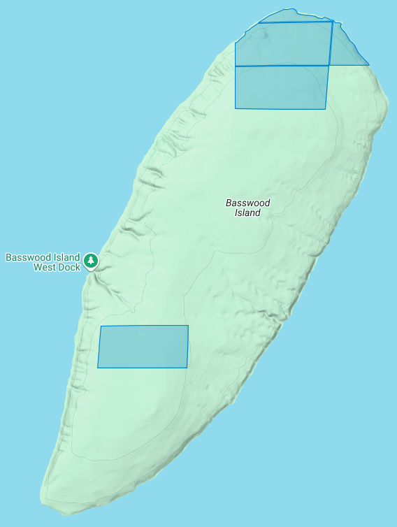
The Apostle Islands National Lakeshore contains four allotments (roughly 290 acres) on Basswood Island:
1) John Baptist Berriot
2) Henry Bresette (a.k.a. Brisette)
3) John Baptist Lemieux
4) Louis Neveaux
In a previous post we briefly mentioned that the infamous John Breckenridge made national news with his land speculation on Basswood Island immediately following the 1854 Treaty of La Pointe. In a few short years Breckinridge would become Vice President of the United States, and also a Confederate States Army brigadier general during the Civil War.
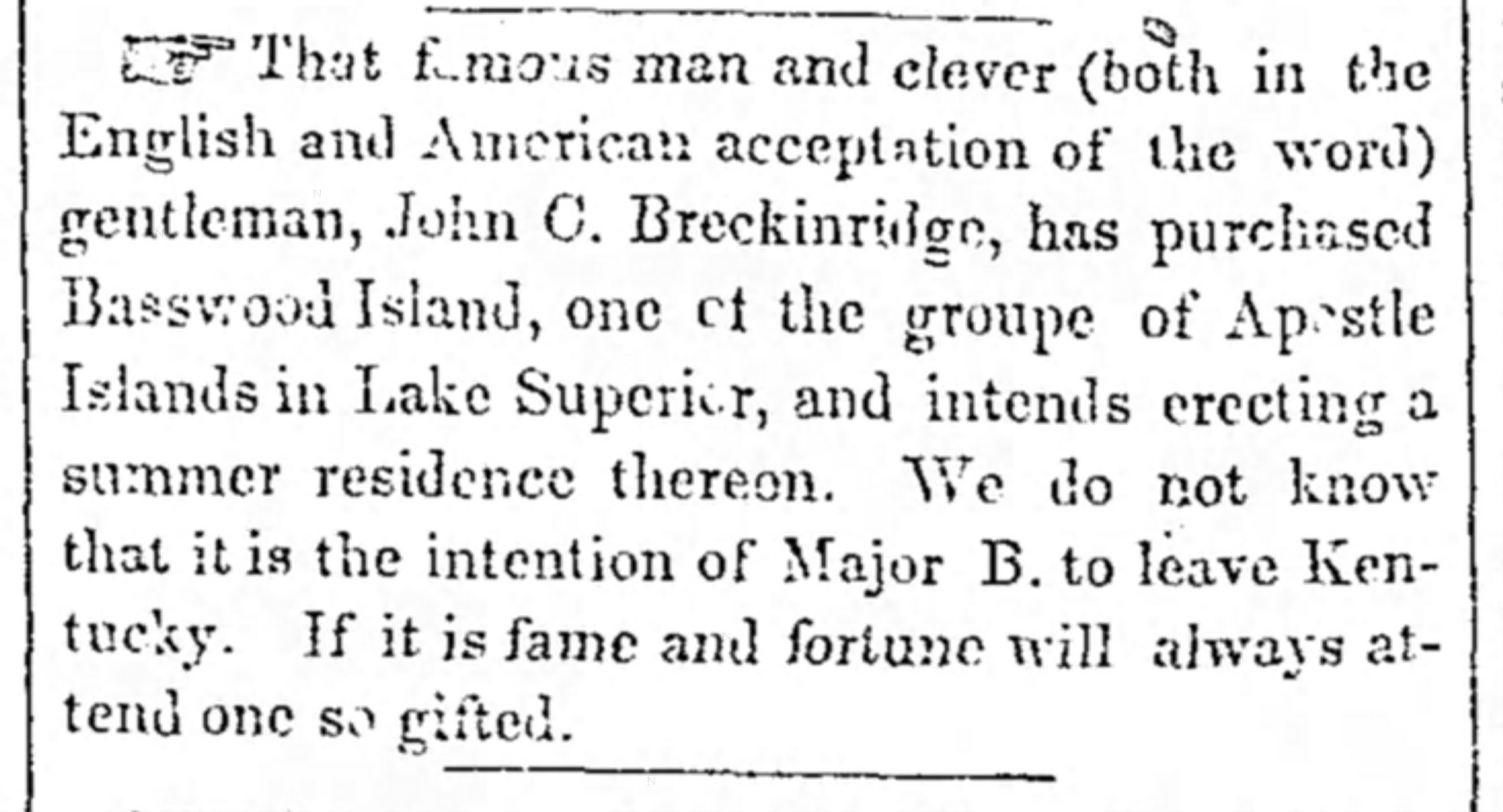
The Louisville Daily Courier [Kentucky], August 14th 1855, Page 4.
Eshkwegwindeg-minis
(roughly translated as “floating at the end or behind island”)
a.k.a. Hermit Island
f.k.a. Austrian Island
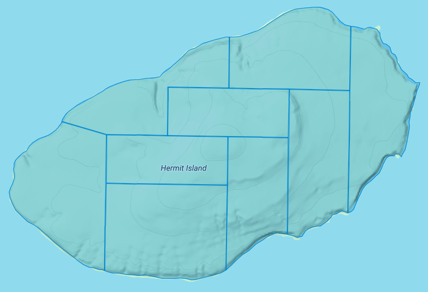
The Apostle Islands National Lakeshore contains nine allotments (roughly 780 acres) covering all of Hermit Island:
1) Josette Deefoe (a.k.a. Defoe)
2) Michael Defoe
3) Francois Dejadin (a.k.a. Artishon) Junior
4) Charles Dingley
5) Mary Dingley
6) Mary DuBay
7) Louis Gaudin (a.k.a. Gordon)
8) John Baptist Goslin (a.k.a. Gauslin)
9) Elizabeth (a.k.a. Isabella) Tremble
The traditional name of Eshkwegwindeg appears to be referencing this island’s location between the mainland and several other Apostle Islands. Today it still remains a central hub between the Red Cliff Reservation, the La Pointe Reservation on the north end of Madeline Island, and the other Apostle Islands with Allotments. It is noteworthy how the entirety of this Island is covered by Allotments, unlike the other aforementioned Islands.
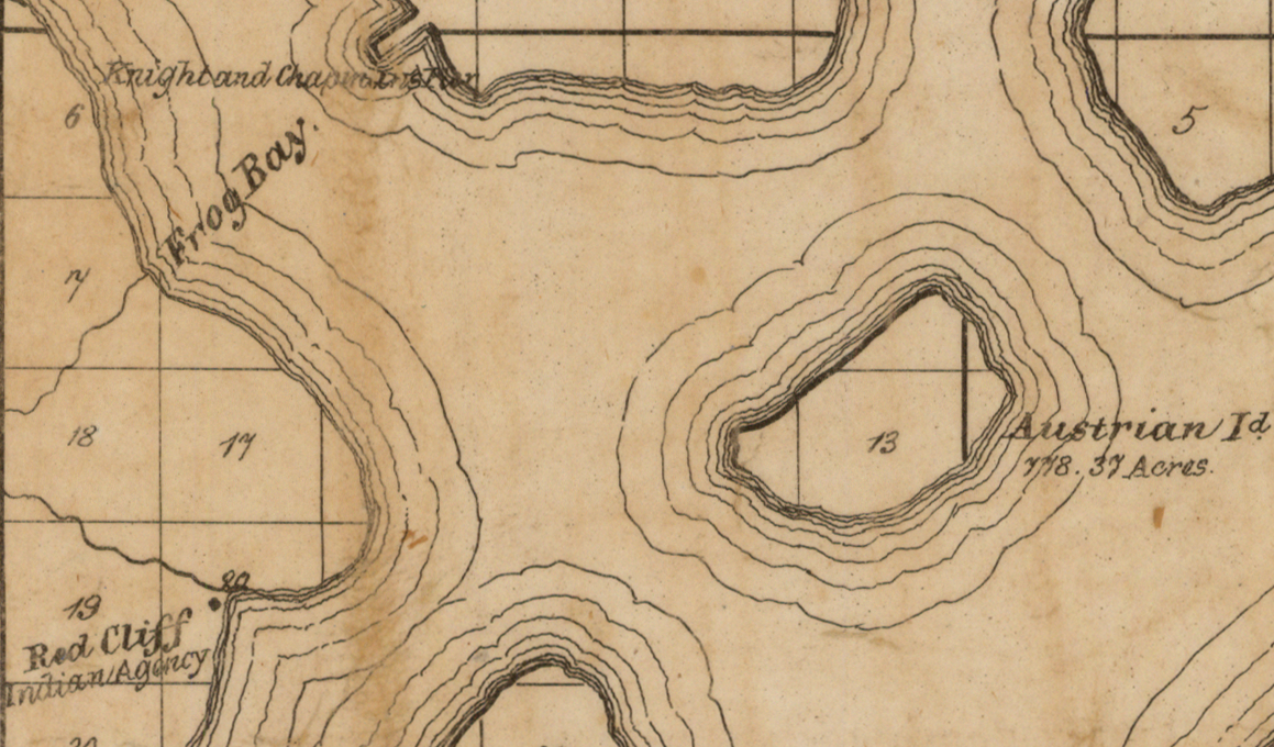
Austrian Island on Asaph Whittlesey’s 1871 map of Apostle Islands and Harbor of Bayfield and Its Surroundings.
~ Wisconsin Historical Society
Modern maps call this Hermit Island in reference to the colorful story of how William Wilson was ostracized from La Pointe and relocated to this Island to live out a solitary life during the Treaty Era. The famous “brownstone king” Frederick Prentice‘s connection to this Island in later decades is also a popular story being told by tour guides in modern times. However, I personally am more interested in exploring the history of how this Island was know as “Austrian Island” between the Wilson and Prentice eras, because it illustrates Julius Austrian’s abuse of Allotments to take private ownership of what should be tribal lands for personal profit.
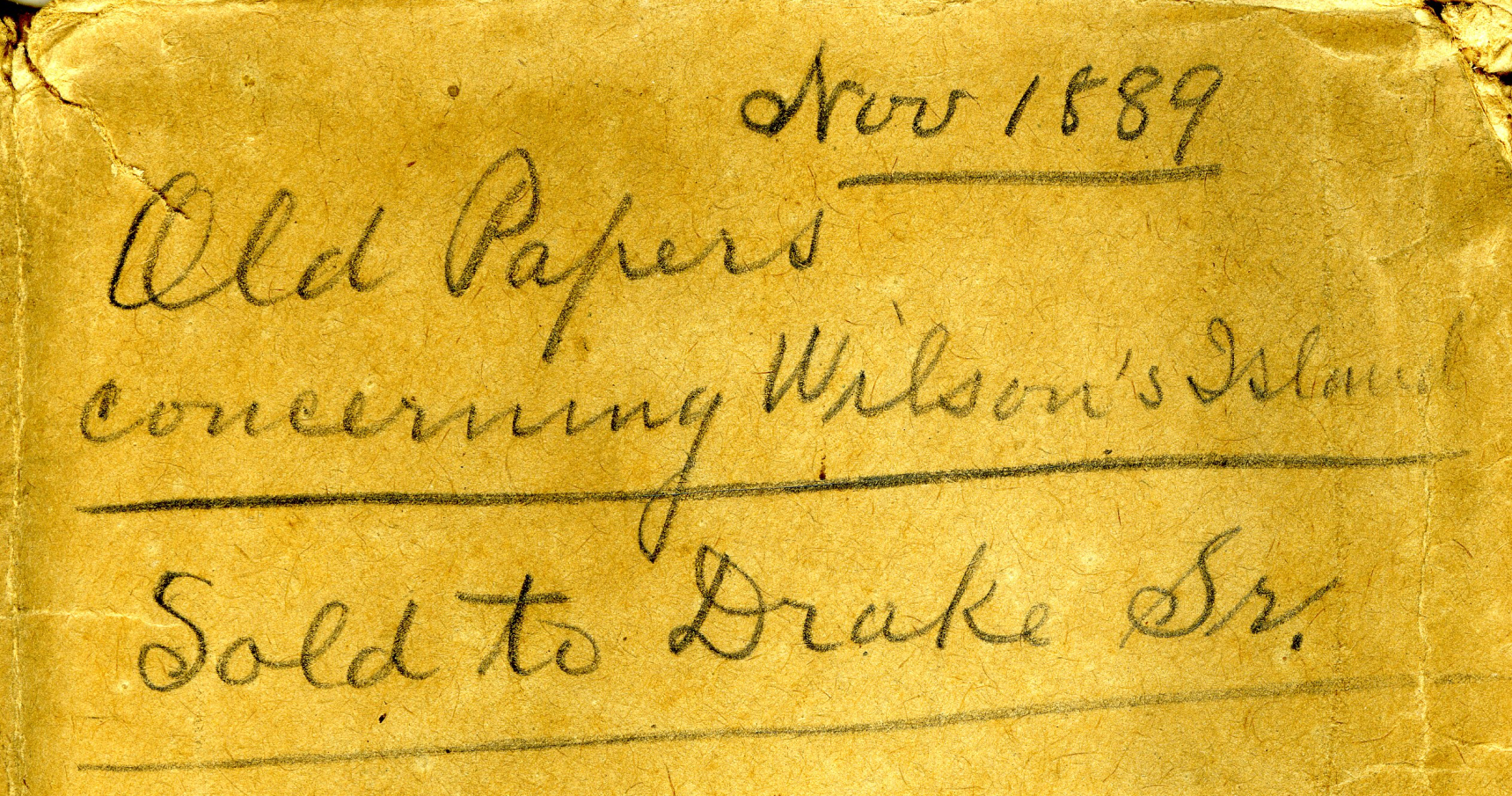
Madeline Island Museum
JULIUS AUSTRIAN PAPERS (2011.158.A) Folder 5:
PAPERS RELATING TO WILSON’S ISLAND (HERMIT ISLAND IN THE APOSTLE ISLANDS ARCHIPELAGO), WISCONSIN (1870-1888)
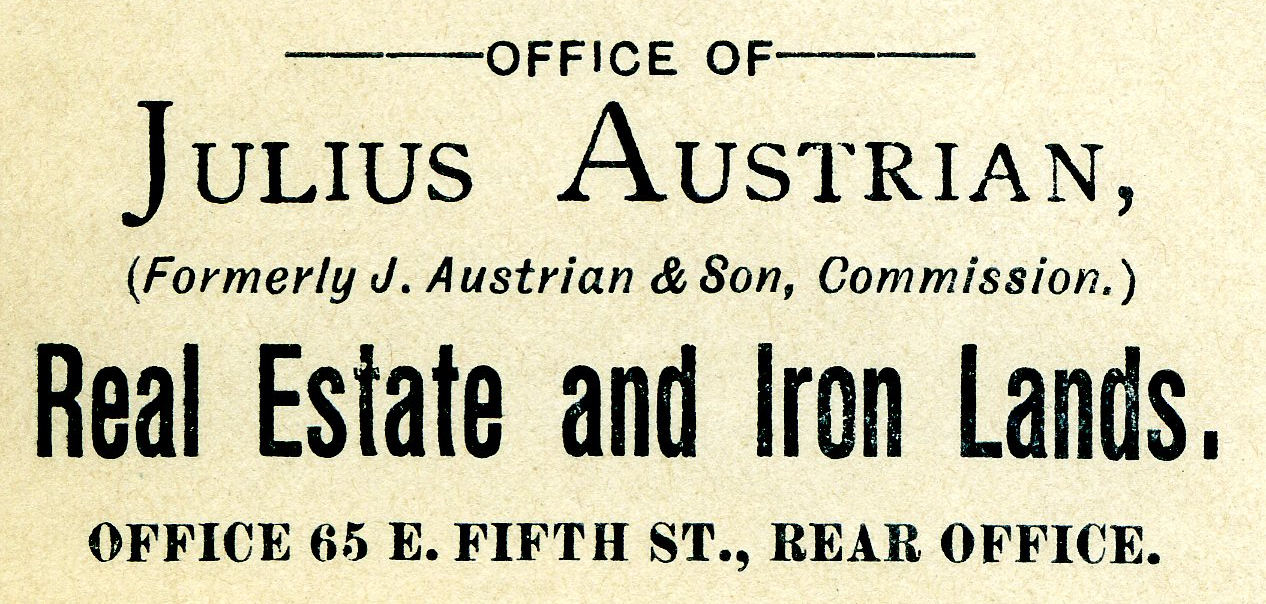
Julius Austrian’s corporate letterhead circa 1888 advertising Allotments for sale.
I personally became very interested in Chequamegon history specifically because of Julius Austrian and his abuse of Allotments to take private ownership of what should be tribal lands in the Penokee Mountains for personal profit, and how that legacy evolved to become what is still known as the La Pointe Iron Company today.
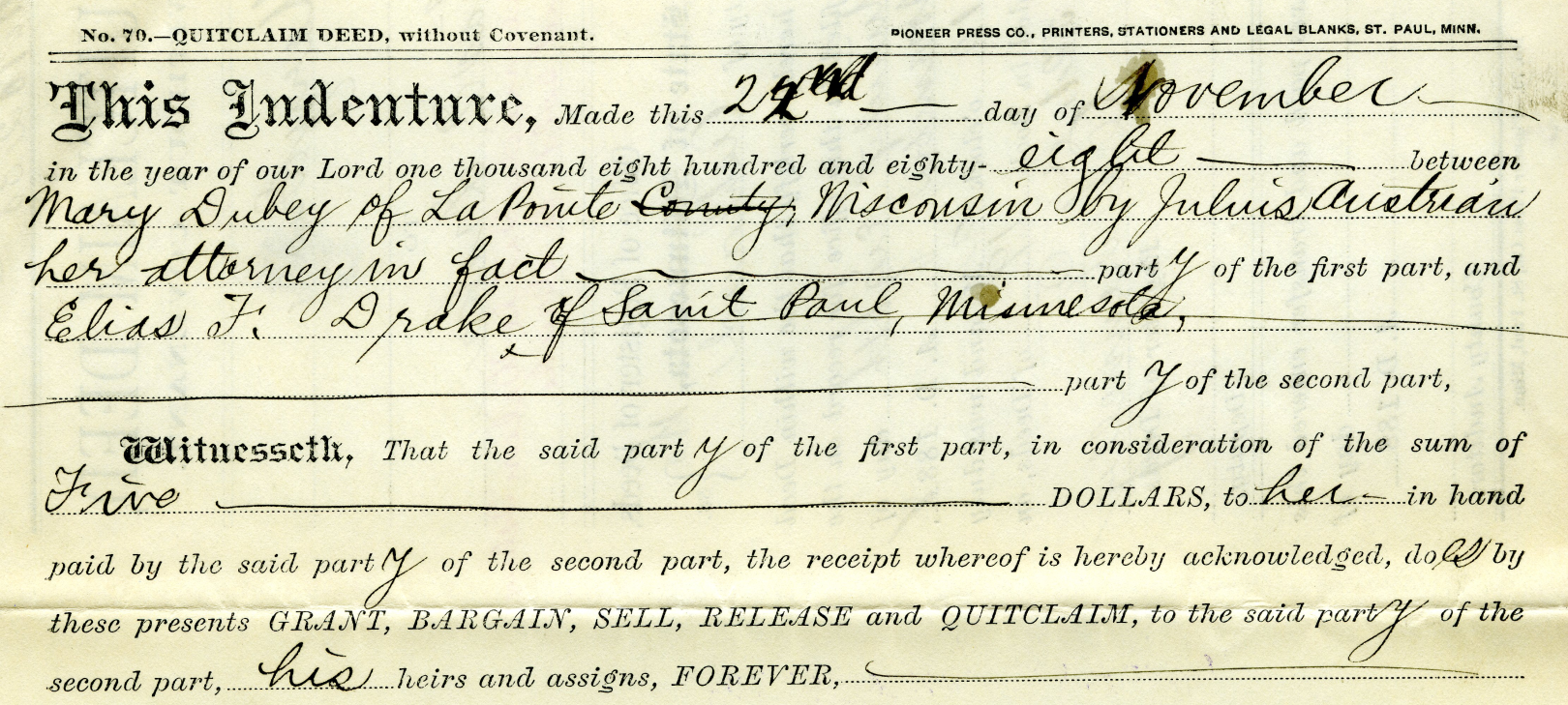
Example of Julius Austrian using Power Of Attorney to buy Mary DuBay’s Allotment for $5 so he could later flip it for profit as private property.
Austrian’s land speculation on Hermit Island follows the same trend of using Allotments via power of attorney over Mixed Blood tribal members of the Lake Superior Chippewa to grab ownership of prime real estate before other land speculators. In the Penokees example, Austrian gave each Mixed Blood $100 to sell their Allotments via Power of Attorney, but here we see how Austrian gave Mary DuBay only $5 for her Allotment on Hermit Island.
My research has been the foundation of academic research in Larry Nesper’s book Our Relations…the Mixed Bloods, and I will continue to post more on this topic in the Austrian Papers on this website.
So what?
Regular readers of Chequamegon History know that my writing style is to post historic documents enhanced with multimedia and sidebars, but omit my own interpretations and and just let readers reach their own conclusions. Leo, on the other hand, is more inclined to speak out about the implications, such as in his posts 19th Century Deer in the Headlights and Slavery, Debt Default, and the Sandy Lake Tragedy. However, in this case, due to Congressman Tom Tiffany’s ongoing efforts despite strong opposition from local governments, I felt it was important to expound on this issue a bit more than I usually do.
Righting a Wrong: Restoring Lands to the Leech Lake Band of Ojibwe
In 2020, the Leech Lake Band of Ojibwe Reservation Restoration Act (Public Law 116-255) returned approximately 11,760 acres of allotted lands wrongfully taken by the Chippewa National Forest back to Tribal ownership and management. The same concept should be applied to repatriate tribal lands in the Apostle Islands National Lakeshore before moving forward with the proposed Apostle Islands National Park and Preserve Act.
Lac Court Oreilles Band of Lake Superior Chippewa v. Walker, Evers
Tribes of the 1854 Chippewa Treaty in Michigan and Wisconsin have won two important lawsuits in recent years due to the fact that their tribal lands should have been reserved under the 1854 Treaty of La Pointe instead of becoming “checkerboarded” from illegal taxation/foreclosures.
Red Cliff Band of Lake Superior Chippewa Indians v. Bayfield County
What started off as a dispute about zoning authority over tribal lands has developed into a constructive partnership. Bayfield County and Red Cliff have developed a Memorandum of Understanding that has led to repatriation of tribal lands within the Red Cliff Reservation. This has led to 2,500 acres being returned by the County to Red Cliff in recent years, with the last 900 acres being completed in 2022.
While returning all County-owned surface rights within the Reservation back to the Tribe has been a tremendous achievement, the County still owns mineral rights within the Red Cliff Reservation. Mineral rights supersede land rights under Wisconsin law, so more work still remains to be done in these land repatriation efforts between Bayfield County and Red Cliff.
Bayfield County should promote their efforts in recent years to help Red Cliff repatriate 2,500 acres of County-owned lands back to tribal ownership, and encourage the Apostle Islands National Lakeshore to return their 3,000 acres of Reservation/Allotments back to tribal ownership.
Frog Bay Tribal National Park
Congressman Tom Tiffany claims that his proposed Apostle Islands National Park and Preserve Act would create the first National Park in Wisconsin. However, Red Cliff already earned that claim to fame in 2012 by establishing the Frog Bay Tribal National Park through an innovative partnership to repatriate Allotments on their Reservation from non-native landowners.
We would much rather see the establishment of a Sand Bay Tribal National Park in Red Cliff, a Chequamegon Point Tribal National Park in Bad River, and Tribal National Parks for the Apostle Islands Allotments, before the proposed Apostle Islands National Park and Preserve. Ultimately these Tribal Lands should be returned to the Lake Superior Chippewa and let them decide whether to manage them as Tribal National Parks or not.
The 1856 Reservation for Chief Buffalo’s Estate
November 5, 2025
Collected & edited by Amorin Mello
This is one of many posts on Chequamegon History exploring the original La Pointe Band Reservations of La Pointe County on Chequamegon Bay, now known as the Bad River and Red Cliff Reservations. Specifically, today’s post is about the 1856 Reservation for Chief Buffalo’s subdivision of the La Pointe Band and how it got selected in accordance with the Sixth Clause of the Second Article of the 1854 Treaty with the Chippewa at La Pointe:
1854 Treaty with the Chippewa at La Pointe
…

Map of La Pointe Band Reservations:
334 – Bad River Reservation
335 – La Pointe Fishing Reservation
341 – Chief Buffalo’s Reservation
342 – Red Cliff Reservation
18th Annual Report of the Bureau of American Ethnology to the Secretary of the Smithsonian Institution 1896-’97
Printed by U.S. Congress in 1899
ARTICLE 2. The United States agree to set apart and withhold from sale, for the use of the Chippewas of Lake Superior, the following-described tracts of land, viz:
…
6th [Clause]. The Ontonagon band and that subdivision of the La Pointe band of which Buffalo is chief, may each select, on or near the lake shore, four sections of land, under the direction of the President, the boundaries of which shall be defined hereafter. And being desirous to provide for some of his connections who have rendered his people important services, it is agreed that the chief Buffalo may select one section of land, at such place in the ceded territory as he may see fit, which shall be reserved for that purpose, and conveyed by the United States to such person or persons as he may direct.
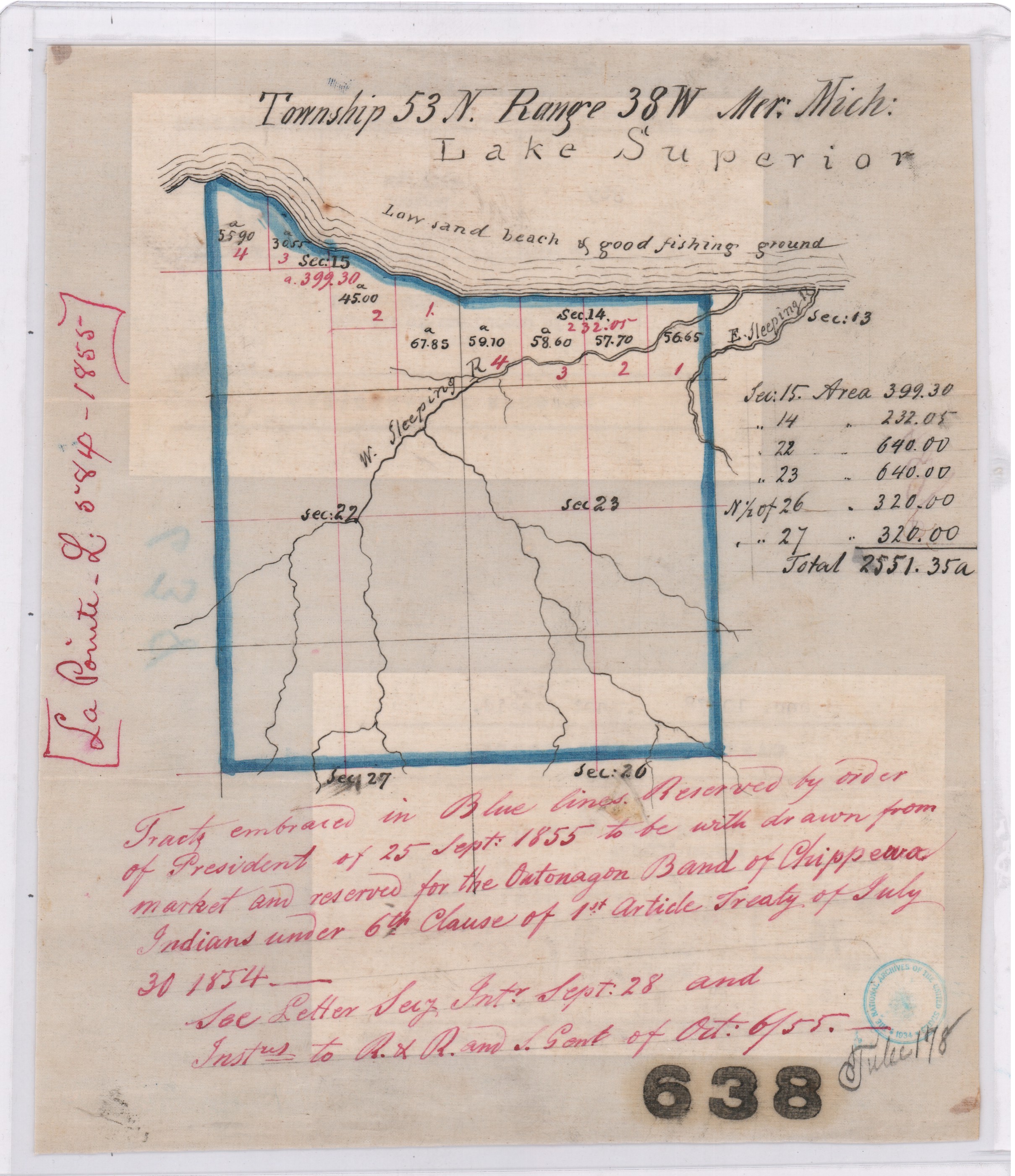
Map of “Tract embraced in blue lines reserved by order of President of 25 September 1855 to be withdrawn from market and reserved for the Ontonagon Band of Chippewa Indians“ on a “low sand beach & good fishing ground”.
Central Map File No. 638 (Tube No. 138)
NAID: 232923886 cites “La Pointe L.584-1855”.
The Ontonagon Band and Chief Buffalo’s Subdivision of the La Pointe Band got lumped together in this clause, so let’s review the Ontonagon Band first. Less than one year after the 1854 Treaty, the Ontonagon Band selected four square miles for their Reservation as approved by President Franklin Pierce’s Executive Order of September 25, 1855. Today the Ontonagon Band Reservation still has its original shape and size from 1855 despite heavy “checkerboarding” of its landownership over time.
In comparison to the Ontonagon Band Reservation, the history of how Chief Buffalo’s Reservation got selected is not so straightforward. Despite resisting and surviving the Sandy Lake Tragedy and Ojibwe Removal, making an epic trip to meet the President at Washington D.C., and securing Reservations as permanent homelands for the Chippewa Bands in the 1854 Treaty, Chief Buffalo of La Pointe died in 1855 before being able to select four square miles for his Subdivsion of the La Pointe Bands.
Fortunately, President Franklin Pierce’s Executive Order of February 21, 1856 withheld twenty-two square miles of land near the Apostle Islands from federal public land sales, allowing Chief Buffalo’s Estate to select four of those twenty-two square miles for their Reservation without competition from squatters and other land speculators, while other prime real estate in the ceded territory of La Pointe County was being surveyed and sold to private landowners by the United States General Land Office.
This 1856 Reservation of twenty-two square miles for Chief Buffalo’s Estate set the stage for what would eventually become the Red Cliff Reservation. We will return to this 1856 Reservation for Chief Buffalo’s Estate in several upcoming posts exploring more records about Red Cliff and the other La Pointe Band Reservations.

Maps marked “A” showing certain lands reserved by the 1854 Treaty:
Central Map File No. 793 (Tube 446)
NAID: 232924228 cites “La Pointe L.579-1855″.
Central Map File No. 816 (Tube 298)
NAIDs: 232924272 & 50926136 cites “Res. Chippewa L.516-1855”.

1878 Copy of President Franklin Pierce’s Executive Order of February 26, 1856 for Chief Buffalo’s Subdivision (aka “Red Cliff”).
NAID: 117092990
Office of Indian Affairs.
(Miscellaneous)
L.801.17.1878
Copy of Ex. Order of Feby. 21. 1856.
Chippewas (Red Cliff.)
Wisconsin.
Enc. in G.L.O. letter of Nov 23, 1878 (above file mark.)
in answer to office letter of Nov. 18, 1878.
Ex. Order File.

Secretary of the Interior
Robert McClelland
Department of the Interior
February 21, 1856
Sir,
I herewith return the diagram enclosed in your letter of the 20th inst, covering duplicates of documents which accompanied your letter of the 6th Sept. last, as well as a copy of the latter, the originals of which were submitted to the President in letter from the Department of the 8th Sept. last and cannot now be found.
You will find endorsements on said diagram explanatory of the case and an order of the President of this date for the withdrawal of the land in question for Indian purposes as recommended.
Respectfully
Your obt. Servt
R McClelland
Secretary
To
Hon Thos A Hendrick
Commissioner of the
General Land Office
(Copy)
General Land Office
September 6, 1855
Hon R. McClelland
Sec. of Interior
Sir:
Enclosed I have the honor to submit an abstract from the Acting Commissioner of Indian Affairs letter of the 5th instant, requesting the withdrawal of certain lands for the Chippewa Indians in Wisconsin, under the Treaty of September 30th, 1854, referred by the Department to this office on the 5th. instant, with orders to take immediate steps for the withdrawal of the lands from sale.
Detail of 1856 Reservation in pencil on “a map marked A.“
Central Map File No. 816 (Tube 298)
NAIDs: 232924272 & 50926136 cites “Res. Chippewa L.516-1855”.
In obedience to the above order I herewith enclose a map marked A. Showing by the blue shades thereon, the Townships and parts of Townships desired to be reserved, no portion of which are yet in market, to wit:
Township 51 N. of Range 3 West 4th Prin. Mer. Wis.
N.E. ¼ of Town 51 N ” 4 ” ” ” “.
Township 52 ” ” 3 & 4 ” ” ” “.
For the reservation of which, until the contemplated Selections under the 6th Clause of the Chippewa Treaty of 30th September 1854 can be made, I respectfully recommend that the order of the President may be obtained.
The requisite reports on the subject of the new surveys, and respecting preemption claims, referred to in the same order, will be prepared and communicated at an early day.
I am respectfully
Your Ob’t Serv’t
Thos. A. Hendricks
Commissioner
Department of the Interior
Feb. 20. 1856
Detail of 1856 Reservation in blue on “duplicate of the original“.
NAID: 117092990
This plat represents by the blue shade, certain land to be withdrawn with a view to a reservation, under Chippewa Treaty of 30 Sept 1854, and as more particularly described in Commissioner of the General Land Office in letter of 6th Sept 1855. The subject was referred to the President for his sanction of the recommendation made in Secretary’s letter of 8th Sept 1855 and the original papers cannot now be found. This is a duplicate of the original, received in letter of Comm’r of the General Land Office of this date and is recommended to the President for his sanction of the withdrawal desired.
R. McClelland
Secretary

1856 Reservation in red and modern Red Cliff in brown. Although different in shape, both are roughly twenty-two square miles in size.
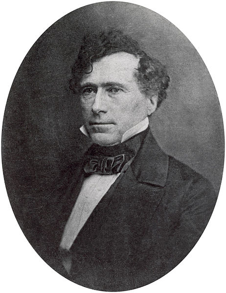
14th United States President
Franklin Pierce
February 21st 1856
Let the withdrawal be made as recommended.
Franklin Pierce
Barber Papers: “Apostle Islands” Summer of 1857
February 13, 2016
By Amorin Mello
Selected letters of the Joel Allen Barber Papers
… continued from the Spring of 1857.
This season (Summer of 1857) of the Barber Papers begins with this editorial commentary from Chequamegon History because the Barber Papers do not contain much information about events that occurred during this time period. Fortunately, letters from Giles Addison Barber preceding this season indicate that he had planned to take his second trip west from Vermont to Lake Superior in order to rejoin his son Joel Allen Barber during the Summer of 1857.
Giles’ first trip in the Spring of 1856 was tragically disrupted by the death of his first son Augustus Hamilton Barber, and was unprepared to reconcile Augustus’ unfinished copper claims, land speculations, and U.S. General Land Office survey contracts during that trip. The vocabulary Giles used to describe employees and politics at the U.S. General Land Office in Superior City were not admirable. Giles sought reconciliation by applying pressure upon national politicians in his social network (particularly Alvah Sabin; U.S. Representative from Vermont), and began preparations for this second trip.
Augustus Hamilton Barber had begun to work closely with George Riley Stuntz earlier in 1852 to survey the far northwestern region of the Wisconsin Territory; their most recent survey together before the Summer of 1857 had been at the Gardens in Odanah of the LaPointe Indian Reservation during the Fall of 1856. Stuntz’s nephew Albert Conrad Stuntz began surveying the Gogebic Iron Range of La Pointe County during the Summer of 1857. Lysander “Gray Devil” Cutler moved to Ironton during the Summer of 1857 as the new managing agent on the Gogebic Iron Range for the Wisconsin & Lake Superior Mining & Smelting Company to operate in collusion with Stuntz’s survey of the Gogebic Iron Range for the U.S. General Land Office.
“Mr. Cutler was appointed the managing agent of this prospective Wisconsin bonanza, at a fair salary, to which was added a liberal amount of the stock of the company. His first task was to perfect the title to the property, and the first step toward it was to take a personal view of the situation and the property. It was a somewhat arduous undertaking, not unfraught with danger. Excepting two or three traders and surveyors, who had stock in the company, the population, which consisted mostly of Indians and half-breeds, viewed this incursion of wealth-hunters from the lower lakes with suspicion and distrust. To add to the difficulties of the situation, other parties owning Sioux script were endeavoring to acquire a title to the mineral range. One man working in the interest of the company the year before, had been discovered, after being missed for some weeks, dead in the forest, near the range. Bruises and other indications of violence on the body gave strong ground for the belief that he had been murdered. Altogether it was a position, the applications for which were not numerous. His [Cutler’s] first trip was made in the Summer of 1857.”
~ History of Milwaukee, Wisconsin:
From Prehistoric Times to the Present Date
Milwaukee Genealogical Society, 1881, page 790.

“IN MEMORY OF
AUGUSTUS H. BARBER
of Cambridge, Vt. U.S. Deputy Surveyor
who was drowned in
Montreal River
Apr. 22. A.D. 1856
Aged 24 yrs. & 8 ms.”
~ FindAGrave.com
The death of this unnamed managing agent that Cutler replaced corresponds with the timing of Augustus’ death in the Spring of 1856. Augustus’ last letters reveal that he had gotten into “A Little Trouble“ and decided to “Let ‘Em Rip“ shortly before his death. Augustus was reported to have drowned below Superior Falls near Ironton and the Mouth of the Montreal River. However, a confidential letter written by Giles to Allen on the first year anniversary of Augustus’ death reveals that the location actually occurred further inland under secret circumstances:
“It must remain a sealed book to us, how Augustus was hurried out of the woods, and why it was so ordained if there, was any ordination about it, till we meet him in another world, which I devoutly hope we may do though I am sorry to say more hoping than expecting.”
Augustus is suspected to have been the unnamed managing agent found dead near the Gogebic Iron Range that Cutler replaced. There was a footpath between the Gogebic Iron Range and Ironton, which supports this speculation. James Smith Buck was an elected official of La Pointe County during the Summer of 1857, and wrote memoirs about working in the Penokee Survey Incidents with Cutler and Stuntz. Buck’s memoirs glorified another traumatic event at Ironton which involved Cutler and his management approach to disciplining the mining company’s Lake Superior Chippewa employees at these locations. Buck did not make any references to the Barbers in his memoirs; however, Asaph Whittlesey published a public retort to Buck’s memoirs with a cryptic allusion to “the Siege of Barlisle“. Whittlesey’s reference is suspected to have been about the murder of Augustus Hamilton Barber.
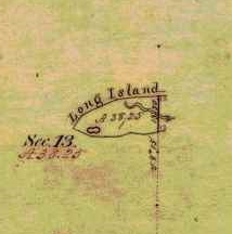
Detail of Chequamegon Point included in the Barber brother’s survey of T47N R4W during the Summer of 1855.
Without further speculation about how the Barber family may have been involved with the 1857 Stuntz/Cutler survey of the Gogebic Iron Range, the rest of this will be dedicated to the 1857 Barber survey of we can focus on the Barber brothers’ survey of what is now the Apostle Islands National Lakeshore.
Joel Allen Barber and his brother Augustus Hamilton Barber began their work to survey the Apostle Islands at Chequamegon Point on Long Island during the Summer of 1855. Augustus and Allen continued their survey of the Apostle Islands during the Winter of 1856:
“We shall go back in a few days and commence surveying around the islands. Now don’t fancy that we cannot survey in the winter, for we have tried it and know better.”
After Augustus’ death, Allen rewrote their original field notes of the Apostle Islands survey during the Winter of 1857, per instructions from their father:
“Keep a strict acct of all the expense of resurveying on the last winters contract, if you get a new one & undertake it, as I am informed that I can get relief from Congress by a special act, paying me all that it will cost to do the work over again, which will be as much for you interest as anybody’s of this please say nothing to any one.”
Allen then renewed their contract for this survey during the Spring of 1857, causing much anxiety for their father despite giving instructions to do this:
“I am surprised to learn that you are going to survey islands so late in the season. Nothing that I can now say will avail any thing else I would caution against trusting too long to the treacherous covering over the dark blue waters. I hope you will have good success and get through without any fatal accidents to your self or to any one of your party.”
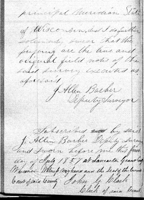
The Barbers’ survey field notes were finally accepted as complete by the U.S. General Land Office during this season; the Summer of 1857.
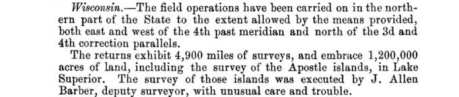
“… the survey of the Apostle Islands, in Lake Superior. The survey of those islands was executed by J. Allen Barber, deputy surveyor, with unusual care and trouble.”
~ Message of the President of the Untied States to the Two Houses of Congress at the Commencement of the Second Session of the Thirty-Fifth Congress, 1858, page 119.
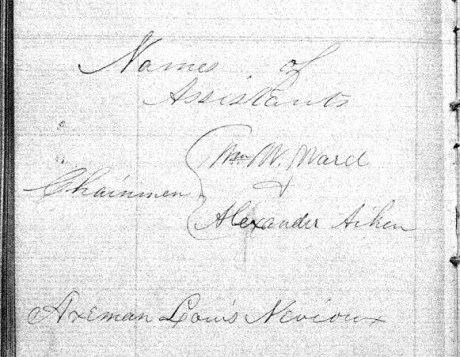
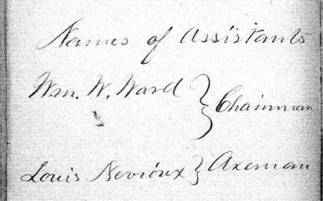
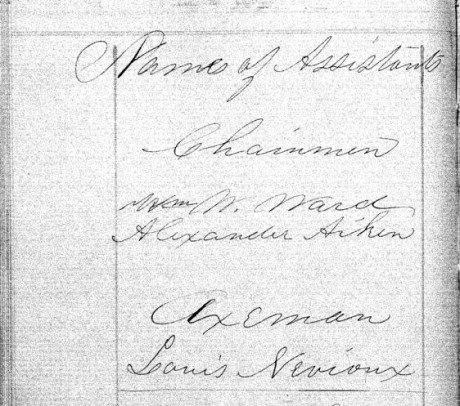
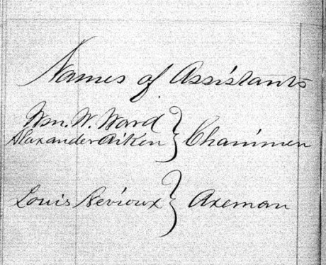
The following documents are the original surveys notes of the Apostle Islands as submitted by Deputy Surveyor Joel Allen Barber during the Summer of 1857. Augustus Hamilton Barber’s former role in these surveys during 1855 and 1856 was not mentioned anywhere in his brother’s survey notes. In lieu, Joel Allen Barber identified three assistants during these surveys:
- William W Ward
- Alexander Aiken
- Louis Nevioux
Aiken and Neveau are familiar surnames in Lake Superior Chippewa communities.
Our transcriptions of selected letters from the Joel Allen Barber Papers are continued below without further editorial commentary:
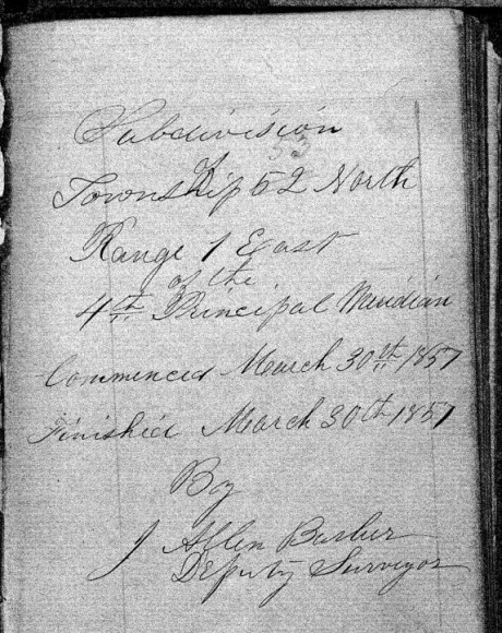
Exterior Field Notes
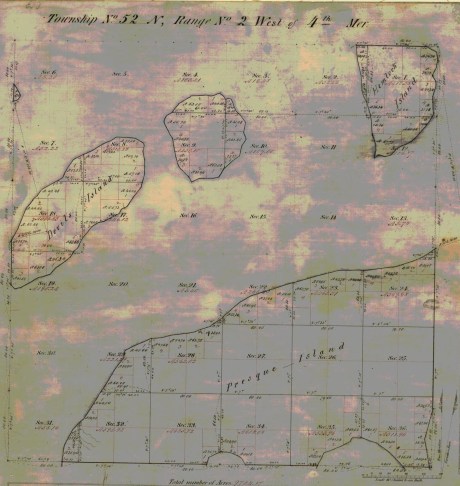
Township 51 North, Range 2 West
Township 52 North, Range 1 West
Township 52 North, Range 2 West
Township 53 North, Range 1 East
Township 53 North, Range 1 West
Township 53 North, Range 2 West
April 1857
Notebook ID: EXT27501
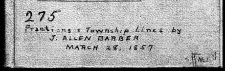
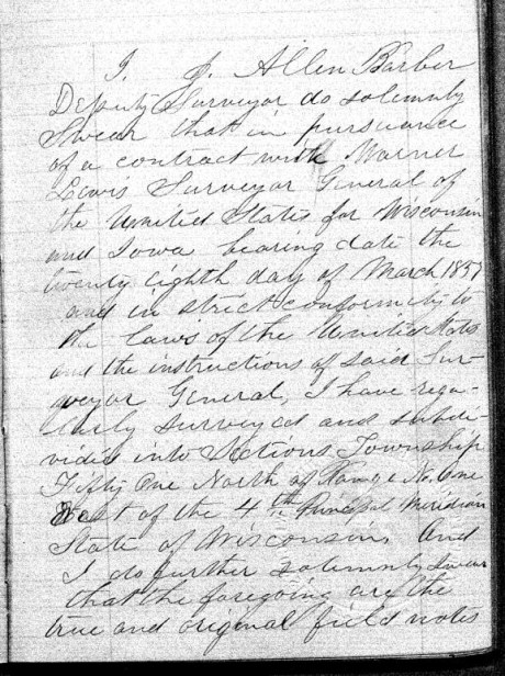
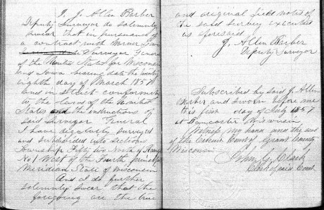
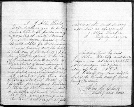
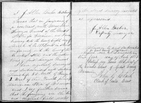
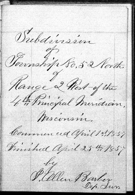
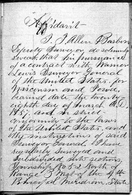
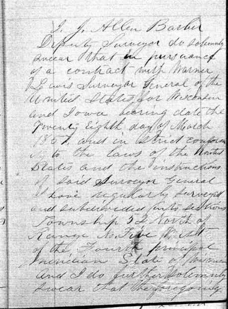
Joel Allen Barber received this survey contract on March 28th, 1857, from Warner Lewis at the General Land Office in Dubuque, Iowa.
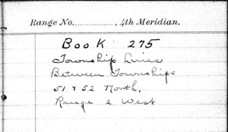
“Township Lines Between Townships 51 & 52 North, Range 2 West”
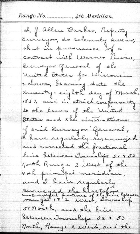
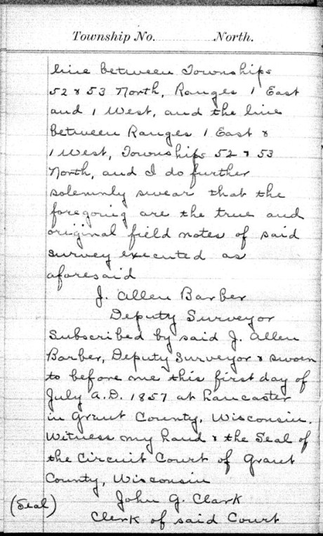
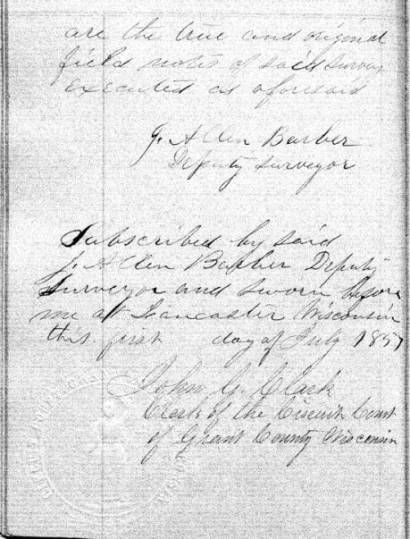
These survey notes were originally sealed in Lancaster, Grant County, on July 1st, 1857.


Interior Field Notes
Barber, J. Allen
Mar. 1857
Notebook ID: INT011E03

“No. 11 T. 46-47-52-&53. R. 1. East”
Township 46 North, Range 1 East
[Joel Allen Barber’s survey notes for this township are referenced by the the Wisconsin Public Land Survey Records, but is are omitted from the General Land Office Records. A survey map published by Charles Whittlesey in 1860 reveals diverse geology, one mineral claim, and part of the ancient Flambeau Trail were documented in this township.]

Detail of T46N-R1E and the surrounding region from Charles Whittlesey’s Geological Map of the Penokie Range, 1860.
Township 47 North, Range 1 East
[One more minor Chequamegon History editorial commentary: Joel Allen Barber’s survey notes of this township are referenced by the Wisconsin Public Land Survey Records, but are omitted from the General Land Office Records. This township is featured in the above detail of Whittlesey’s 1860 map. It is near Ironton; and contains the Mouth of the Montreal River, Superior Falls, and Saxon Falls.]

Superior Falls at the mouth of the Montreal River, as featured in the stereograph “View on Montreal River” by Whitney & Zimmerman from St. Paul, circa 1870.
~ Wikimedia Commons
Township 52 North, Range 1 East
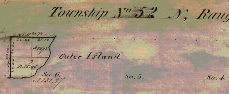
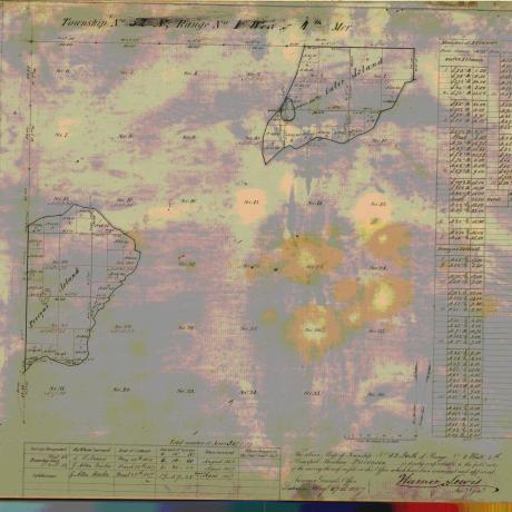
Barber’s survey of T52N R1E included the southeast corner of Outer Island, the rest of this township is occupied by Lake Superior. There are no survey notes available for this township, it was included in the survey of T53N R1E for convenience.
Township 53 North, Range 1 East

Barber’s survey of T53N R1E features the east half of Outer Island, the rest of this township is occupied by Lake Superior.
“Commenced March 30th, 1857. Finished March 30th, 1857.”

Barber’s assistants were William W. Ward, Alexander Aiken, and Louis Nevioux.

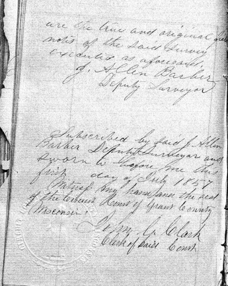
These survey notes were sealed in Lancaster, Grant County, on July 1st, 1857. Barber’s assistants were not signatories.
Interior Field Notes
Township 51 North, Range 1 West
Barber, J. Allen
Apr. 1857
Notebook ID: INT010W04

Barber’s survey of T51N R1W included Michigan Island, Gull Island, and a corner of “Presque Island” (Stockton Island).
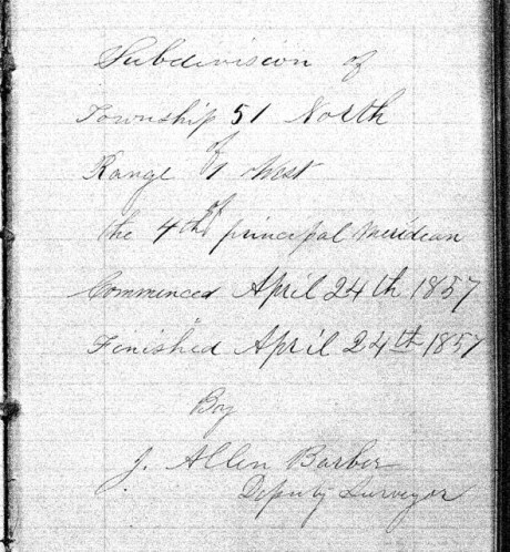
“Commenced April 24th, 1857, and finished on April 28th, 1857.”

Barber’s assistants were William W. Ward, Alexander Aiken, and Louis Nevioux.

These survey notes were sealed in Lancaster, Grant County, on July 1st, 1857. Barber’s assistants were not signatories.
Interior Field Notes
Township 52 North Range 1 West
Barber, J. Allen
Apr. 1857
Notebook ID: INT010W05
Barber’s survey of T52N R1W included the northeastern end of “Presque Island” (Stockton Island) and the south western end of Outer Island.

“Commenced March 28th, 1857. Finished March 31st, 1857.”

Barber’s assistants were William W Ward, Alexander Aiken, and Louis Nevioux.
These survey notes were sealed in Lancaster, Grant County, on July 1st, 1857. Barber’s assistants were not signatories.
Interior Field Notes
Township 53 North Range 1 West
Barber, J. Allen
Apr. 1857
Notebook ID: INT010W06

Barber’s survey of T53N R1W included the northwestern part of Outer Island. The rest of this township is covered by Lake Superior.

“Commenced March 29th, 1857. Finished March 30th, 1857.”

Barber’s assistants were William W Ward, Alexander Aiken, and Louis Nevioux.
These survey notes were sealed in Lancaster, Grant County, on July 1st, 1857. Barber’s assistants were not signatories.
Interior Field Notes
Township 50 North Range 2 West
Barber, J. Allen
Apr. 1857
Notebook ID: INT019W04

Barber’s survey of T51 R2W included part of Madeline Island.

“Commenced April 22nd, 1857. Finished April 23rd, 1857.”
Barber’s assistants were William W Ward, Alexander Aiken, and Louis Nevioux.
These survey notes were sealed in Lancaster, Grant County, on July 1st, 1857. Barber’s assistants were not signatories.
Interior Field Notes
Township 51 North Range 2 West
Barber, J. Allen
Apr. 1857
Notebook ID: INT019W02

Barber’s survey of T51N R2W included the LaPointe Indian Reservation Fishing Grounds on the north end of Madeline Island, and parts of “Wilson’s Island” (Hermit Island) and “Presque Island” (Stockton Island).

“Commenced April 17th, 1857, and finished April 23rd, 1857.”

Barber’s assistants were William W Ward, Alexander Aiken, and Louis Nevioux.
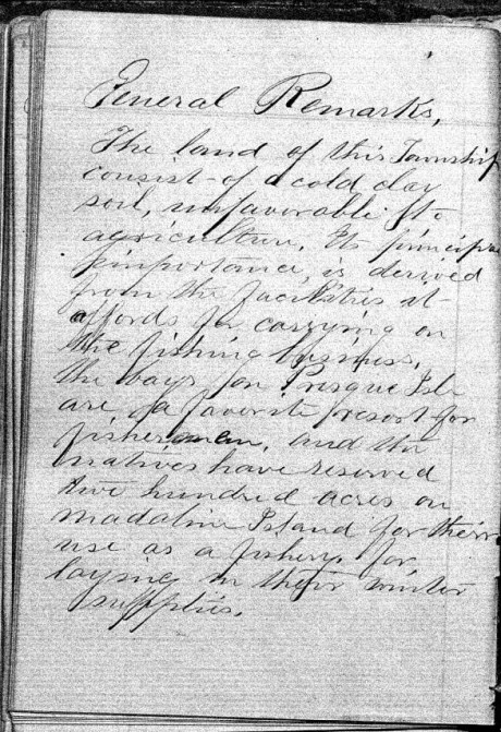
“The land of this Township consists of a cold clay soil, unfavorable to agriculture. It’s principle importance is derived from the facilities it afford for carrying on the fishing business, the bays for Presque Isle are a favorite resort for fishermen, and the natives have reserved two hundred acres on Madeline Island for their use as a fishery, for laying in their winter supplies.”


These survey notes were sealed in Bayfield on May 30th, 1857, by Samuel Stuart Vaughn as Justice of the Peace for LaPointe County. Alexander Aiken was not a signatory, yet William W Ward and Louis Nevioux (“his X mark”) were included as signatories. This nuance was not explained.

There appears to be something written or drawn behind the smaller sheet in this scan of Barber’s original survey field notes.
Interior Field Notes
Township 52 North Range 2 West
Barber, J. Allen
Apr. 1857
Notebook ID: INT019W03
Barber’s survey of T52N R2W included “Devil’s Island” (Manitou Island), an unnamed island (Ironwood Island), and parts of “Hemlock Island” (Cat Island), and “Preque Island” (Stockton Island).
“Commenced April 1st, 1857. Finished April 25th, 1857.”

“There is but little good land in this Township, the greater part being of a very inferior quality, there is some good White Pine on Presque & Hemlock Islands.”
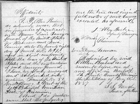
These survey notes were sealed in Bayfield on May 30th, 1857, by Samuel Stuart Vaughn as Justice of the Peace for LaPointe County. Alexander Aiken was not a signatory, yet William W Ward and Louis Nevioux (“his X mark”) were signatories. This nuance was not explained.
Interior Field Notes
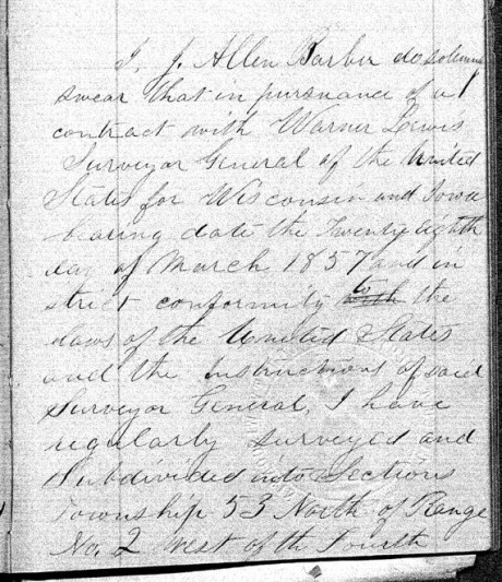
Township 53 North Range 2 West
Barber, J. Allen
Apr. 1857
Notebook ID: INT019W05
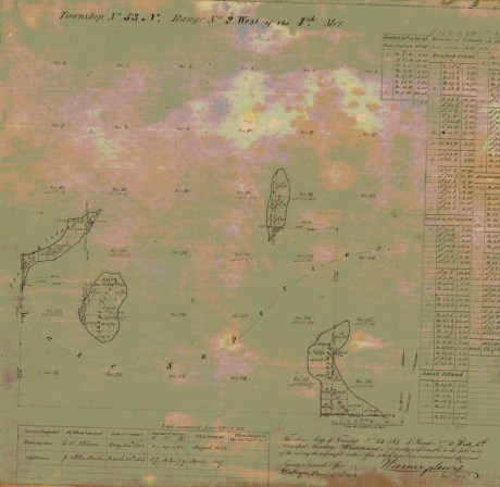
Barber’s survey of T53N R2W included “Shoal Island” (South Twin Island), an unnamed island (North Twin Island), the north end of “Hemlock Island” (Cat Island), and the east end of “Ironwood Island” (Rocky Island).

Barber’s assistants were William W Ward, Alexander Aiken, and Louis Nevioux.
These survey notes were sealed in Lancaster, Grant County on July 1st, 1857. Barber’s assistants were not signatories.
Interior Field Notes
Township 51 North Range 3 West
Barber, J. Allen
Apr. 1857
Notebook ID: INT030W06

Barber’s survey of T51N R3W included parts of “Bass Island” (Basswood Island), “Wilson’s Island” (Hermit Island), Oak Island, and the mainland where the Red Cliff Band of Lake Superior Chippewa was located six years later in 1863.

“Commenced April 14th, 1857. Finished April 28th, 1857.”

Barber’s assistants were William W Ward and Alexander Aiken, and Louis Nevieux.

“The land in this Township is all high and rolling and is pretty well adapted to agricultural pursuits, the soil is gravelly and in some places stony. The poorest portions are Wilson’s and Bass Islands, which contain more clay. Much good White Pine & Hemlock are found on the Main shore near the Lake.”

These survey notes were sealed by Samuel Stuart Vaughn at Bayfield on May 30th, 1857, by Samuel Stuart Vaughn as Justice of the Peace for LaPointe County. Alexander Aiken was not signatories.
Interior Field Notes
Township 52 North Range 3 West
Barber, J. Allen
Apr. 1857
Notebook ID: INT030W07
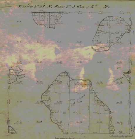
Barber’s survey of T52N R3W included parts of Oak Island, “Devil’s Island” (Manitou Island), Bear Island, “Cranberry Island” (Raspberry Island), an unnamed island (Otter Island), and the mainland where the Red Cliff Band of Lake Superior Chippewa were located six years later in 1863.

“Commenced April 4th, 1857. Finished April 29th, 1857.”
Barber’s assistants were William W Ward, and Louis Nevioux. Alexander Aiken is not identified as an assistant in this survey.

“The principal part of the land of this Township is of good quality. Oak & Bear Islands are very high and rolling with a good soil. The Island in the N.E. part of the Township is more level, but it soil is of a good quality.”

These survey notes were sealed by Samuel Stuart Vaughn in Bayfield on May 30th, 1857, as Justice of Peace for LaPointe County.
Interior Field Notes
Township 53 North Range 3 West
Barber, J. Allen
Apr. 1857
Notebook ID: INT030W08

Barber’s survey of T53N R3W included an unnamed island (Devils Island), the west end of “Ironwood Island” (Rocky Island), and the north end of Bear Island.

“Commenced Apr 4th, 1857. Finished Apr. 7th, 1857.”
Barber’s assistants were William W Ward, Alexander Aiken, and Louis Nevioux.
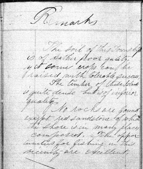
“The soil of this Township is of rather poor quality, yet some crops can be raised with tolerable success. The timber of these Islands is quite dense but is of inferior quality. No rocks are found except red sandstone of which the shore is in many places composed. The opportunities for fishing in this vicinity are excellent.”

These survey notes were sealed in Lancaster, Grant County on July 1st, 1857. Barber’s assistants were not signatories.
Interior Field Notes
Township 51 North Range 4 West
Barber, J. Allen
Apr. 1857
Notebook ID: INT040W04

Barber’s survey of T51N R4W on the mainland was used to locate the Red Cliff Reservation years later in 1863

“Commenced April 30th, 1857. Finished May 8th, 1857.”

Barber’s assistants were William W Ward, Alexander Aiken, and Loius Nevioux.
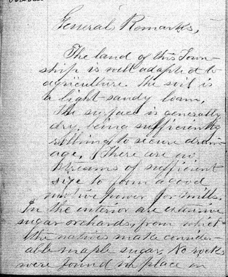
“The land of this Township is well adapted to agriculture. The soil is a light-sandy loam. The surface is generally dry, being sufficiently rolling to secure drainage. There are no streams of sufficient size to power a good motive power for mills. In the interior are extensive sugar orchards, from which the natives make considerable maple sugar. No wells were found in place in …”

“… this Township, but it belongs to the sand-stone formation and is overlaid by drift,- in some places to the depth of several hundred feet. No houses or other improvements were noticed.”


These survey notes were sealed in Bayfield on May 30th, 1857, by Samuel Stuart Vaughn as Justice of Peace for LaPointe County. Alexander Aiken was not a signatory, yet William W Ward and Louis Nevioux (“his X mark”) were signatories. This nuance was not explained.
Interior Field Notes
Township 52 North Range 4 West
Barber, J. Allen
Apr. 1857
Notebook ID: INT040W05

Barber’s survey of T52N R4W included Point Detour on the mainland, an unnamed island (York Island), the west end of “Cranberry Island” (Raspberry Island), and the east end of “Sand River Island” (Sand Island).

“Commenced April 8th, 1857. Finished April 12th, 1857.”
Barber’s assistants were William W Ward, Alexander Aiken, and Louis Nevioux.
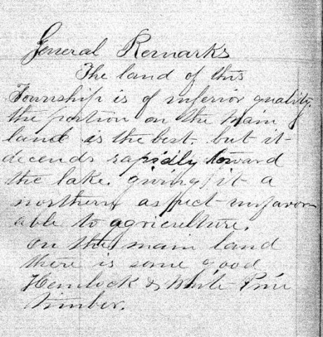
“The land of this Township is of inferior quality, the portion on the main land is the best, but it descends rapidly toward the lake, giving it a northern aspect – unfavorable to agriculture. On the main land there is some good Hemlock & White Pine timber.”


This survey contract was at Bayfield on May 30th, 1857, by Samuel Stuart Vaughn as Justice of Peace for LaPointe County. Alexander Aiken was not a signatory, yet William W Ward and Louis Nevioux (“his X mark”) were signatories. This nuance was not explained.
Interior Field Notes
Township 52 North Range 5 West
Barber, J. Allen
Apr. 1857
Notebook ID: INT050W04

Barber’s survey of T52N R5W included “Steamboat Island” (Eagle Island), “Little Steamboat Island” (no longer exists), and most of Sand Island.
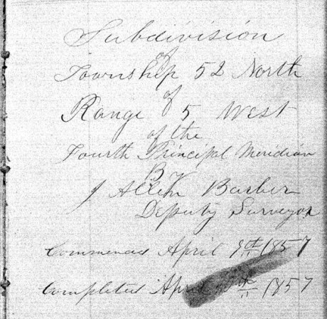
“Commenced April 8th, 1857. Finished April 10th, 1857.”

Barber’s assistants were William W Ward, Alexander Aiken, and Louis Nevioux.
These survey notes were sealed in Lancaster, Grant County on July 1st, 1857. Barber’s assistants were not signatories.
Bayfield Mercury, August 22, 1857.
IRONTON
The Barbers did business with William Herbert and others at Ironton. The activities of “the company“ during the Summer of 1857 are detailed the Penokee Survey Incidents.
“… Wm. Herbutt, was here in 1847-48 prospecting for copper for the American Fur Company.”
Report of the City Statistician, Volume 1, page 58.
Week before last we took a trip to Ironton and the interior in company with Mr. HERBERT, the Agent of the town, and several others, and promised to give our readers an account of the the town and country back of it, but inasmuch as some kind friend took the liberty of abstracting our memorandum book from our pocket, we cannot give as definite an account as we would like.

Lake Superior surveyor, American geologist, and Harvard University professor Josiah Dwight Whitney. ~ Portrait of Whitney by Silas Selleck, 1863.
Ironton is situated on the South shore about 20 miles from this place and three fourths of a mile from the mouth of the Montreal river, which is the State line between this State and Michigan. Its harbor is good and the water is of sufficient depth for any of the largest class of steamers. The company are building a splended pier, 400 feet long, and when finished it probably will be one of the most substantial piers on the Lake, and will cost about $5000. They have also erected a large Hotel, two stories high, and we also noticed the materials on the ground for putting up several frame buildings, and arrangemnts has been made for the erection of a steam sawmill with 40 horse power, which is to be completed this summer, and will cost from $10,000 to $12,000. The lots are 40 x 125, except on 1st and 2nd streets which are 40 x 128.
The site of the town is beautiful, — about a third of it is on a nice level next to the Lake, and then it ascends gradually in benches back for one or two miles. Its near proximity to the Copper mines on the Montreal river and the Iron range back, together with the farming lands, which by the bye is not equalled on Lake Superior, must needs make Ironton a town of no small importance. The company are cutting out a good road from Ironton to the Iron range some 16 miles in length.
While there we visited the Falls on the Montreal river, the scenery of which cannot be surpassed on the Lakes. The lower falls are 60 feet high and the upper falls are 80 feet. They are about three miles apart. The indication of mineral between the two falls and especially on Mr. WHITNEY’s claim, bids as fair for large deposits of copper as any that has yet been discovered and certainly has a good surface show as had any of the mines that are now being developed.
We could say much more about the Iron range and surrounding country, but defer it until another time. The town was only laid out in February last, and it already bids fair for a bright future. Go on gentlemen, we hope you will build up a large town, and help develop the vast resources of the Great Northwest, and we will aid you what we can.
Lancaster Aug 30th 1857
Dear Son.
Maria Green Barber. She came to Lancaster to visit her in-laws, and to consider relocating there from Vermont.
A week or more since I rec’d a letter from [you?] at Bayfield by [????] I am happy a safe arrival for which I am very thankful. But in it you don’t say where your father is. [??? ???ably] return or whether he intends to come here, or go home, or other ways expecting me to go along [???? ?? ?? ????? ????] I have not had a letter from him since you left but father Barber goes on some other which road. I have not [?????] to [????????] as [????????????] about [?? ???] there to get it. Mr Burr [??????] last [??? ???] – I did not know what to do about going but as the friends here so I Pray [??? ???] he would come this way to see to his produce [????????] was out state with [???] that time I thought but to wait a little longer. [?? ??? ????] an [????] I wished I would stay with this while [?? ??? ???] as they are rather homesick [???] the [???? ??? ??? ??? ????? ??????] [????? ??? ??????] I enjoy myself better with them than of [???? other affect?] as it is such a pleasant family and very young so comfortable quilt – Last evening the Bank came up here to give me a seranade. They had intended to come [???] and were expected and They were invited in and treated to Coffee, pie, and cake and the girls gave them the best music – as they said – on the Piano they ever heard – Then they all joined in several songs They went to nearly every house in the town “to wake them up.” Yesterday Miss Barber got in another exhibition – that is, had them (her exhibit) & had something to speak – had a stage in [??????] grove where they exhibited had a pre-mer. I tried to get some – singing – pretty much failed in that – tried to get out there hard and wholely failed – and on the whole, not “[????? ???????]” they say.
It is quite [??????] here [????????? ???? ????] several others of summer complained. There has been hot months but, [???? ?????? ???? ????? ????? ?????] Esq [M????] wife are considered [????? ??? ????]
I wish I knew what [???? ? ??? ???? ????] as your father would write [??????? ??????? ????? ??? ???] to go home without [???????] at last. Got a line from [Albe?] last week. Suppose he [????] to as he does not [?????] to [???????????????????] but “lying ‘round longer.” [??? ??] very sorry he was not that [winter?] the government and instruction of some one who would have taught him something useful and kept in a study.
It is beautiful weather now for gathering the grain [????? ???? ????? ????????? ????] will be plenty of them but very little fruit of any kind this year.
I expect father will come this week without fail if he comes at all. Have heard nothing more about going to Cassville. Uncle Allen is building a large office and Cyrus and Thode are building the Evert house fence. Write often, till you come, to your
Mother
Johnson Sept 20 /57
Friend Allen
May I call you friend? I will venture for if I recollect right we were once very good friends and I hope that we are so still although we are far distant from each other, and may never meet again in this world, have you forgotten Hattie? I have not forgotten Allen and probably never shall, and were I even disposed I have a small gillon badge laid safely away which brings forcably to my mind an old friend who much resembles you, when I once knew. Amherst said he presumed you would not think I was very naughty to dare to write to you, so I thought I would take the liberty. I have written enough so I will close by saying please don’t forget the Johnson people for we shall never forget you.
Good night
Hattie C.
P.S.
Beware of those pretty squaws out there.
Allen,
I want you to understand that Miss Hattie & Miss Hastings & Carls & I have spent the evening here together at Mr. Caldwells upstairs & have had all sorts of good times. That is, as far as I am concerned. (I do not speak for the ladies) & I have enjoyed myself “excruciatingly” (as Hattie suggests) considering the company & the advantages I had.
That’s all
Am
Lancaster Sept 20th 1857
Dear Son.

Portrait of George Riley Stuntz. ~ The Eye of the North-west: First Annual Report of the Statistican of Superior, Wisconsin by Frank Abial Flower, 1890, page 26.
I will venture to write once more to you tho I have no evidence that my letters ever reach you. I have had two letters from you but not one from father since you left here. One from him to Mr Burr of Sept 15-6th appears to be the only one he has sent here since you arrival. Why he has not written to me to let me know what to do about going home I cannot understand, but here I am yet, and shall stay, until he either comes or writes he is not coming. I should have written several times to him, had I not expected him every week [??????????] letter [????] that you had not [??????] from [???????] I had not gone home with Mr B. Mr Stunts [visited?] here, and said he was going [??????] to La Pointe [???? ??????] you have learned the state of affairs before this. Mr [??] returned home last night having been about now a few weeks, had a fortunate trip tho on Lake Ontario there was a high wind and every passenger very sick. I am thankful to have escaped that, but something else may happen to us when I do go. Oh how I do dread the journeys.
I am confident that your father will be here this week, that is if he is not still too sick to come – which I greatly fear he is. If he is still there when this arrives he may [c??????] it as much to him as to you. How I wish you would confide to travel there this fall and to remain with [me?] [?????] to me the [??????????] and remain there this winter [?????????????????????????????????????????????????????]
There will be a County Fair held here this week – the grounds in full view of Uncle Jay’s where I am now stopping. I shall probably see some of the best food [ration?] of this great country. I went, two weeks since to McCartney and Cassville with Allen and family. Had a pleasant ride, but it was very warm and dusty. Mc has a beautiful place, the largest orchard in the county, I suppose, as they will have 500 bushels this fall. It is on the highest land 2 miles east of the Miss. river. But perhaps you have been there, if not you have seen the river at other points. I was wishing to see the “great river” and went to Cassville for that purpose. It is certainly worth the trouble of going to see. Aunt Sa’h pointed out to me a high sharp bluff which Augustus climbed and left his name out on the white bark of a [tree?]. To me, how interesting – almost sacred does every thing appear where he has left the impress of his work. There is nothing can bring so forcibly to our minds a dear departed friend, as a sight of the productions of his hands or his mind. So, if we would be remembered with pleasure and gratitude we must do something for the good of every being with whom we have to do.
“IN MEMORY OF
AUGUSTUS H. BARBER
of Cambridge, Vt. U.S. Deputy Surveyor
who was drowned in
Montreal River
Apr. 22. A.D. 1856
Aged 24 yrs. & 8 ms.”
~ FindAGrave.com
I hope your father has placed the marble he sent me enclosed the grave of the dear one who lies on the land here, I feared shall never have the melancholy satisfaction of visiting the cursed spot. It hardly know whether I can wish to behold the terrible scene where he lost his prime life. I cannot but fear that those of my family now in that inhospitable shore may be laid beside that line [??] bed grave that we may all live to [???? ???? ?????].
And land flowing with milk and sugar – than which no better can be found, at least I have yet found a place better adapted in all respects to make life comfortable. With labor and care we can have all that is desirable there – without those we can h should have little enjoyment here unless we are content to live in poverty and filth. One thing alone would discourage me from coming to this Western world, where in the great uncertainty or procuring a constant convenient supply of good soft water. Here, at Jay’s, their Cistern leaks and they have to fix up the pump and have to draw it from the bottom where it [????? ?? ???] with a pail and string, as they do at Allen’s and Thode’s you know there is no cistern and they manage to catch some in tubs to wash with.
It would almost kill Marth and the girls to bring enough from the spring near as it is, based on when they get it, it is good for nothing to wash with in that it is cleansed with [??? ?? ???]. I never yet saw water so convenient, plenty and good as it is at our old home.
Mr. Harris [?????] died about 3 weeks since, and Mrs. Mills is not expected to live but a few days – perhaps hours. It has been very healthy most of the [senses?] People from other places come here to spent the summer on account of the known healthfulness of the place. One gentleman from Cleveland, with consumption, and the Drs said, come – at the end of the 1 week, he had gained 12 lbs – Says he will buy property and stay here. [Sherman Page?] is here – has commenced a select school.
I have no more to [??????????????????????????]
your Mother
Aunt Lucy is unwell to day and I have [????] the [?????].
All friends well but Allen who has his old complaint.
Am sorry this ink is not black & you can read it.
To be continued in the Fall of 1857…
La Pointe Bands Part 1
April 19, 2015
By Leo Filipczak

(Click to Enlarge)
On March 8th, I posted a map of Ojibwe people mentioned in the trade journals of Perrault, Curot, Nelson, and Malhoit as a starting point to an exploration of this area at the dawn of the 19th Century. Later the map was updated to include the journal of John Sayer.
In these journals, a number of themes emerge, some of which challenge conventional wisdom about the history of the La Pointe Band. For one, there is very little mention of a La Pointe Band at all. The traders discuss La Pointe as the location of Michel Cadotte’s trading depot, and as a central location on the lakeshore, but there is no mention of a large Ojibwe village there. In fact, the journals suggest that the St. Croix and Chippewa River basins as the place where the bulk of the Lake Superior Ojibwe could be found at this time.
In the post, I repeated an argument that the term “Band” in these journals is less identifiable with a particular geographical location than it is with a particular chief or extended family. Therefore, it makes more sense to speak of “Giishkiman’s Band,” than of the “Lac du Flambeau Band,” because Giishkiman (Sharpened Stone) was not the only chief who had a village near Lac du Flambeau and Giishkiman’s Band appears at various locations in the Chippewa and St. Croix country in that era.
In later treaties and United State’s Government relations, the Ojibwe came to be described more often by village names (La Pointe, St. Croix, Fond du Lac, Lac du Flambeau, Lac Courte Oreilles, Ontonagon, etc.), even though these oversimplified traditional political divisions. However, these more recent designations are the divisions that exist today and drive historical scholarship.
So what does this mean for the La Pointe Band, the political antecedent of the modern-day Bad River and Red Cliff Bands? This is a complicated question, but I’ve come across some little-known documents that may shed new light on the meaning and chronology of the “La Pointe Band.” In a series of posts, I will work through these documents.
This series is not meant to be an exhaustive look at the Ojibwe at Chequamegon. The goal here is much narrower, and if it can be condensed into one line of inquiry, it is this:
Fourteen men signed the Treaty of 1854 as chiefs and headmen of the La Pointe Band:
Ke-che-waish-ke, or the Buffalo, 1st chief, his x mark. [L. S.]
Chay-che-que-oh, 2d chief, his x mark. [L. S.]
A-daw-we-ge-zhick, or Each Side of the sky, 2d chief, his x mark. [L. S.]
O-ske-naw-way, or the Youth, 2d chief, his x mark. [L. S.]
Maw-caw-day-pe-nay-se, or the Black Bird, 2d chief, his x mark. [L. S.]
Naw-waw-naw-quot, headman, his x mark. [L. S.]
Ke-wain-zeence, headman, his x mark. [L. S.]
Waw-baw-ne-me-ke, or the White Thunder, 2d chief, his x mark. [L. S.]
Pay-baw-me-say, or the Soarer, 2d chief, his x mark. [L. S.]
Naw-waw-ge-waw-nose, or the Little Current, 2d chief, his x mark. [L. S.]
Maw-caw-day-waw-quot, or the Black Cloud, 2d chief, his x mark. [L. S.]
Me-she-naw-way, or the Disciple, 2d chief, his x mark. [L. S.]
Key-me-waw-naw-um, headman, his x mark. [L. S.]
She-gog headman, his x mark. [L. S.]
If we consider a “band” as a unit of kinship rather than a unit of physical geography, how many bands do those fourteen names represent? For each of those bands (representing core families at Red Cliff and Bad River), what is the specific relationship to the Ojibwe villages at Chequamegon in the centuries before the treaty?
The Fitch-Wheeler Letter
Chequamegon History spends a disproportionately large amount of time on Ojibwe annuity payments. These payments, which spanned from the late 1830s to the mid-1870s were large gatherings, which produced colorful stories (dozens from the 1855 payment alone), but also highlighted the tragedy of colonialism. This is particularly true of the attempted removal of the payments to Sandy Lake in 1850-1851. Other than the Sandy Lake years, the payments took place at La Pointe until 1855 and afterward at Odanah.
The 1857 payment does not necessarily stand out from the others the way the 1855 one does, but for the purposes of our investigation in this post, one part of it does. In July of that year, the new Indian Agent at Detroit, A.W. Fitch, wrote to Odanah missionary Leonard Wheeler for aid in the payment:
Office Michn Indn Agency
Detroit July 8th 1857
Sir,
I have fixed upon Friday August 21st for the distribution of annuities to the Chippewa Indians of Lake Supr. at Bad River for the present year. A schedule of the Bands which are to be paid there is appended.
I will thank you to apprise the LaPointe Indians of the time of payment, so that they should may be there on the day. It is not necessary that they should be there before the day and I prefer that they should not.
And as there was, according to my information a partial failure in the notification of the Lake De Flambeau and Lake Court Oreille Indians last year, I take the liberty to entrust their notification this year to you and would recommend that you dispatch two trusty Messengers at once, to their settlements to notify them to be at Bad River by the 21st of August and to urge them forward with all due diligence.
It is not necessary for any of these Indians to come but the Chiefs, their headmen and one representative for each family. The women and children need not come. Two Bands of these Indians, that is Negicks & Megeesee’s you will notice are to be notified by the same Messengers to be at L’Anse on the 7th of September that they may receive their pay there instead of Bad River.
I presume that Messengers can be obtained at your place for a Dollar a day each & perhaps less and found and you will please be particular about giving them their instructions and be sure that they understand them. Perhaps you had better write them down, as it is all important that there should be no misunderstanding nor failure in the matter and furthermore you will charge the Messenger to return to Bad River immediately, so that you may know from them, what they have done.
It is my purpose to land the Goods at the mo. of Bad River somewhere about the 1st of Aug. (about which I will write you again or some one at your place) and proceed at once to my Grand Portage and Fond Du Lac payments & then return to Bad River.
Schedule of the Bands of Chipps. of Lake Supr. to be notified of the payment at Bad River, Wisn to be made Friday August 21st for the year 1854.
____________________________
La Pointe Bands.
__________
Maw kaw-day pe nay se [Blackbird]
Chay, che, qui, oh, [Little Buffalo/Plover]
Maw kaw-day waw quot [Black Cloud]
Waw be ne me ke [White Thunder]
Me she naw way [Disciple]
Aw, naw, quot [Cloud]
Naw waw ge won. [Little Current]
Key me waw naw um [Canoes in the Rain] {This Chief lives some distance away}
A, daw, we ge zhick [Each Side of the Sky]
Vincent Roy Sen. {head ½ Breeds.}
Lakes De Flambeau & Court Oreille Bands.
__________
Keynishteno [Cree]
Awmose [Little Bee]
Oskawbaywis [Messenger]
Keynozhance [Little Pike]
Iyawbanse [Little Buck]
Oshawwawskogezhick [Blue Sky]
Keychepenayse [Big Bird]
Naynayonggaybe [Dressing Bird]
Awkeywainze [Old Man]
Keychewawbeshayshe [Big Marten]
Aishquaygonaybe–[End Wing Feather]
Wawbeshaysheence [Little Marten] {I do not know where this Band is but notify it.}
__________
And Negick’s [Otter] & Megeesee’s [Eagle] Bands, which (that is Negicks and Megeesees Bands only) are to be notified by the same Messengers to go to L’Anse the 7th of Sept. for their payt.
Very respectfully
Your Obedt Servt,
A W Fitch
Indn. Agent
Rev. L H Wheeler
Bad River msn.
Source: Wheeler Family Papers, Wisconsin Historical Society, Ashland, WI
This letter reveals that in 1857, three years after the Treaty of La Pointe called for the creation of reservations for the La Pointe, Lac du Flambeau, and Lac Courte Oreilles Bands, the existence of these bands as singular political entities was still dubious. The most meaningful designation attached to the bands in the instructions to Wheeler is that of the chief’s name.
Canoes in the Rain and Little Marten clearly live far from the central villages named in the treaty, and Nigig (Otter) and Migizi (Eagle) whose villages at this time were near Lac Vieux Desert or Mole Lake aren’t depicted as attached to any particular reservation village.

Edawigijig (Edawi-giizhig “Both Sides of the Sky”), 1880 (C.M. Bell, Smithsonian Digital Collections)
Additionally, Fitch makes no distinction between Red Cliff and Bad River. Jechiikwii’o (Little Buffalo) and Vincent Roy Sr. representing the La Pointe mix-bloods could be considered “Red Cliff” chiefs while the rest would be “Bad River.” However, these reservation-based divisions are clearly secondary to the kinship/leadership divisions.
This indicates that we should conceptualize the “La Pointe Band” for the entire pre-1860 historical period as several bands that were not necessarily all tied to Madeline Island at all times. This means of thinking helps greatly in sorting out the historical timeline of this area.
This is highlighted in a curious 1928 statement by John Cloud of Bad River regarding the lineage of his grandfather Edawi-giizhig (Each Side of the Sky), one of the chiefs who signed the 1854 Treaty), to E. P. Wheeler, the La Pointe-born son of Leonard Wheeler:
AN ABRAHAM LINCOLN INDIAN MEDAL
Theodore T. Brown
This medal was obtained by Rev. E. P. Wheeler during the summer of 1928 at Odanah, on the Bad River Indian Reservation, from John Cloud, Zah-buh-deece, a Chippewa Indian, whose grandfather had obtained it from President Abraham Lincoln. His grandfather, A-duh-wih-gee-zhig, was a chief of the La Pointe band of Chippewa. His name signifies “on both sides of the sky or day.” His father was Mih-zieh, meaning a “fish without scales.” The chieftain- ship of A-duh-wih-gee-zhig was certified to by the U. S. Commissioner of Indian Affairs on March 22, 1880.
His father, Mih-zieh, was one of the three chiefs who led the original migration of the Chippewa to Chequamegon Bay, the others being Uh-jih-jahk, the Crane, and Gih-chih-way-shkeenh, or the “Big Plover.” The latter was also sometimes known as Bih-zih-kih, or the “Buffalo.”
A-duh-wih-gee-zhig was a member of the delegation of Lake Superior Chippewa chiefs who went to Washington to see President Lincoln under the guidance of Benjamin G. Armstrong, during the winter of 1861…
~WISCONSIN ARCHEOLOGIST. Vol. 8, No. 3 pg.103
The three chiefs mentioned as leading the “original migration” are well known to history. Waabajijaak, the White Crane, was the father of Ikwezewe or Madeline Cadotte, the namesake of Madeline Island. According to his great-grandson, William Warren, White Crane was in the direct Crane Clan lineage that claimed chieftainship over the entire Ojibwe nation.
Mih-zieh, or Mizay (Lawyerfish) was a prominent speaker for the La Pointe band in the early 19th Century. According to Janet Chute’s research, he was the brother of Chief Buffalo, and he later settled at Garden River, the village of the great “British” Ojibwe chief Zhingwaakoons (Little Pine) on the Canadian side of the Sault.
Bizhiki, of course, is Chief Buffalo, the most famous of the La Pointe chiefs, who died in 1855. Gichi-Weshkii, his other name, is usually translated meaning something along the lines of “Great First Born,” “Great Hereditary Chief,” or more literally as “Great New One.” John Cloud and E. P. Wheeler identify him as the “Big Plover,” which is interesting. Buffalo’s doodem (clan) was the Loon, but his contemporary Zhingwaakoons was of the Plover doodem (Jiichiishkwenh in Ojibwe). How this potentially relates to the name of Buffalo’s son Jechiikwii’o (identified as “Snipe” by Charles Lippert) is unclear but worthy of further investigation.
The characterization of these three chiefs leading the “original migration” to Chequamegon stands at odds with everything we’ve ever heard about the first Ojibwe arrival at La Pointe. The written record places the Ojibwe at Chequamegon at least a half century before any of these chiefs were born, and many sources would suggest much earlier date. Furthermore, Buffalo and White Crane are portrayed in the works of William Warren and Henry Schoolcraft as heirs to the leadership of the “ancient capital” of the Ojibwes, La Pointe.
Warren and Schoolcraft knew Buffalo personally, and Warren’s History of the Ojibways even includes a depiction of Buffalo and Daagwagane (son of White Crane, great uncle of Warren) arguing over which of their ancestors first reached Chequamegon in the mists of antiquity. Buffalo and Daawagane’s exchange would have taken a much different form if they had been alive to see this “original migration.”
Still, Cloud and Wheeler’s statement may contain a grain of truth, something I will return to after filling in a little background on the controversies and mysteries surrounding the timeline of the Ojibwe bands at La Pointe.
TO BE CONTINUED
Chief Buffalo Picture Search: Introduction
May 26, 2013
Click the question mark under the picture to see if it shows Chief Buffalo.


 ?
?


Buffalo, the 19th-century chief of the La Pointe Ojibwe, is arguably the most locally-famous person in history of the Chequamegon region. He is best known for his 1852 trip to Washington D.C., undertaken when he was thought to be over ninety years old. Buffalo looms large in the written records of the time, and makes many appearances on this website.
He is especially important to the people of Red Cliff. He is the founding father of their small community at the northern tip of Wisconsin in the sense that in the Treaty of 1854, he negotiated for Red Cliff (then called the Buffalo Estate or the Buffalo Bay Reservation) as a separate entity from the main La Pointe Band reservation at Bad River. Buffalo is a direct ancestor to several of the main families of Red Cliff, and many tribal members will proudly tell of how they connect back to him. Finally, Buffaloʼs fight to keep the Ojibwe in Wisconsin, in the face of a government that wanted to move them west, has served as an inspiration to those who try to maintain their cultural traditions and treaty rights. It is unfortunate, then, that through honest mistakes and scholarly carelessness, there is a lot of inaccurate information out there about him.
During the early twentieth century, the people of Red Cliff maintained oral traditions about about his life while the written records were largely being forgotten by mainstream historians. However, the 1960s and ʻ70s brought a renewed interest in American Indian history and the written records came back to light. With them came no fewer than seven purported images of Buffalo, some of them vouched for by such prestigious institutions as the State Historical Society of Wisconsin and the U.S. Capitol. These images, ranged from well-known lithographs produced during Buffaloʼs lifetime, to a photograph taken five years after he died, to a symbolic representation of a clan animal originally drawn on birch bark. These images continue to appear connected to Buffalo in both scholarly and mainstream works. However, there is no proof that any of them show the La Pointe chief, and there is clear evidence that several of them do not show him.
The problem this has created is not merely one of mistaken identity in pictures. To reconcile incorrect pictures with ill-fitting facts, multiple authors have attempted to create back stories where none exist, placing Buffalo where he wasnʼt, in order for the pictures to make sense. This spiral of compounding misinformation has begun to obscure the legacy of this important man, and therefore, this study attempts to sort it out.
Bizhikiwag
The confusion over the images stems from the fact that there was more than one Ojibwe leader in the mid-nineteenth century named Bizhiki (Buffalo). Because Ojibwe names are descriptive, and often come from dreams, visions, or life experiences, one can be lead to believe that each name was wholly unique. However, this is not the case. Names were frequently repeated within families or even outside of families. Waabojiig (White Fisher) and Bugone-Giizhig (Hole in the Day) are prominent examples of names from Buffaloʼs lifetime that were given to unrelated men from different villages and clans. Buffalo himself carried two names, neither of which was particularly unique. Whites usually referred to him as Buffalo, Great Buffalo, or LaBoeuf, translations of his name Bizhiki. In Ojibwe, he is just as often recorded by the name Gichi-Weshkii. Weshkii, literally “new one,” was a name often given to firstborn sons in Ojibwe families. Gichi is a prefix meaning “big” or “great,” both of which could be used to describe Buffalo.

Nichols and Nyholm translate Bizhiki (Besheke, Peezhickee, Bezhike, etc.) as both “cow” and “buffalo.” Originally it meant “buffalo” in Ojibwe. As cattle became more common in Ojibwe country, the term expanded to include both animals to the point where the primary meaning of the word today is “cow” in some dialects. These dialects will use Mashkodebizhiki (Prairie Cow) to mean buffalo. However, this term is a more recent addition to the language and was not used by individuals named Buffalo in the mid- nineteenth century. (National Park Service photo)
One glance at the 1837 Treaty of St. Peters shows three Buffalos. Pe-zhe-kins (Bizhikiins) or “Young Buffalo” signed as a warrior from Leech Lake. “Pe-zhe-ke, or the Buffalo” was the first chief to sign from the St. Croix region. Finally, the familiar Buffalo is listed as the first name under those from La Pointe on Lake Superior. It is these two other Buffalos, from St. Croix and Leech Lake, whose faces grace several of the images supposedly showing Buffalo of La Pointe. All three of these men were chiefs, all three were Ojibwe, and all three represented their people in Washington D.C. Because they share a name, their histories have unfortunately been mashed together.
Who were these three men?

Treaty of St. Peters (1837) For more on Dagwagaane (Ta-qua-ga-na), check out the People Index.
The familiar Buffalo was born at La Pointe in the middle of the 18th century. He was a member of the Loon Clan, which had become a chiefly clan under the leadership of his grandfather Andeg-wiiyas (Crowʼs Meat). Although he was already elderly by the time the Lake Superior Ojibwe entered into their treaty relationship with the United States, his skills as an orator were such that by the Treaty of 1854, one year before his death, Buffalo was the most influential leader not only of La Pointe, but of the whole Lake Superior country.
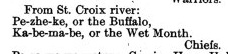
Treaty of St. Peters (1837) For more on Gaa-bimabi (Ka-be-ma-be), check out the People Index.
William Warren, describes the St. Croix Buffalo as a member of the Bear Clan who originally came to the St. Croix from Sault Ste. Marie after committing a murder. He goes on to declare that this Buffaloʼs chieftainship came only as a reward from traders who appreciated his trapping skills. Warren does admit, however, that Buffaloʼs influence grew and surpassed that of the hereditary St. Croix leaders.

Treaty of St. Peters (1837) For more on Flat Mouth, check out the People Index.
The “Young Buffalo,” of the Pillager or Leech Lake Ojibwe of northern Minnesota was a war chief who also belonged to the Bear Clan and was considerably younger than the other two Buffalos (the La Pointe and St. Croix chiefs were about the same age). As Biizhikiins grew into his later adulthood, he was known simply as Bizhiki (Buffalo). His mark on history came largely after the La Pointe Buffaloʼs death, during the politics surrounding the various Ojibwe treaties in Minnesota and in the events surrounding the US-Dakota War of 1862.
The Picture Search
In the coming months, I will devote several posts to analyzing the reported images of Chief Buffalo that I am aware of. The first post on this site can be considered the first in the series. Keep checking back for more.
