The 1856 Reservation for Chief Buffalo’s Estate
November 5, 2025
Collected & edited by Amorin Mello
This is one of many posts on Chequamegon History exploring the original La Pointe Band Reservations of La Pointe County on Chequamegon Bay, now known as the Bad River and Red Cliff Reservations. Specifically, today’s post is about the 1856 Reservation for Chief Buffalo’s subdivision of the La Pointe Band and how it got selected in accordance with the Sixth Clause of the Second Article of the 1854 Treaty with the Chippewa at La Pointe:
1854 Treaty with the Chippewa at La Pointe
…

Map of La Pointe Band Reservations:
334 – Bad River Reservation
335 – La Pointe Fishing Reservation
341 – Chief Buffalo’s Reservation
342 – Red Cliff Reservation
18th Annual Report of the Bureau of American Ethnology to the Secretary of the Smithsonian Institution 1896-’97
Printed by U.S. Congress in 1899
ARTICLE 2. The United States agree to set apart and withhold from sale, for the use of the Chippewas of Lake Superior, the following-described tracts of land, viz:
…
6th [Clause]. The Ontonagon band and that subdivision of the La Pointe band of which Buffalo is chief, may each select, on or near the lake shore, four sections of land, under the direction of the President, the boundaries of which shall be defined hereafter. And being desirous to provide for some of his connections who have rendered his people important services, it is agreed that the chief Buffalo may select one section of land, at such place in the ceded territory as he may see fit, which shall be reserved for that purpose, and conveyed by the United States to such person or persons as he may direct.
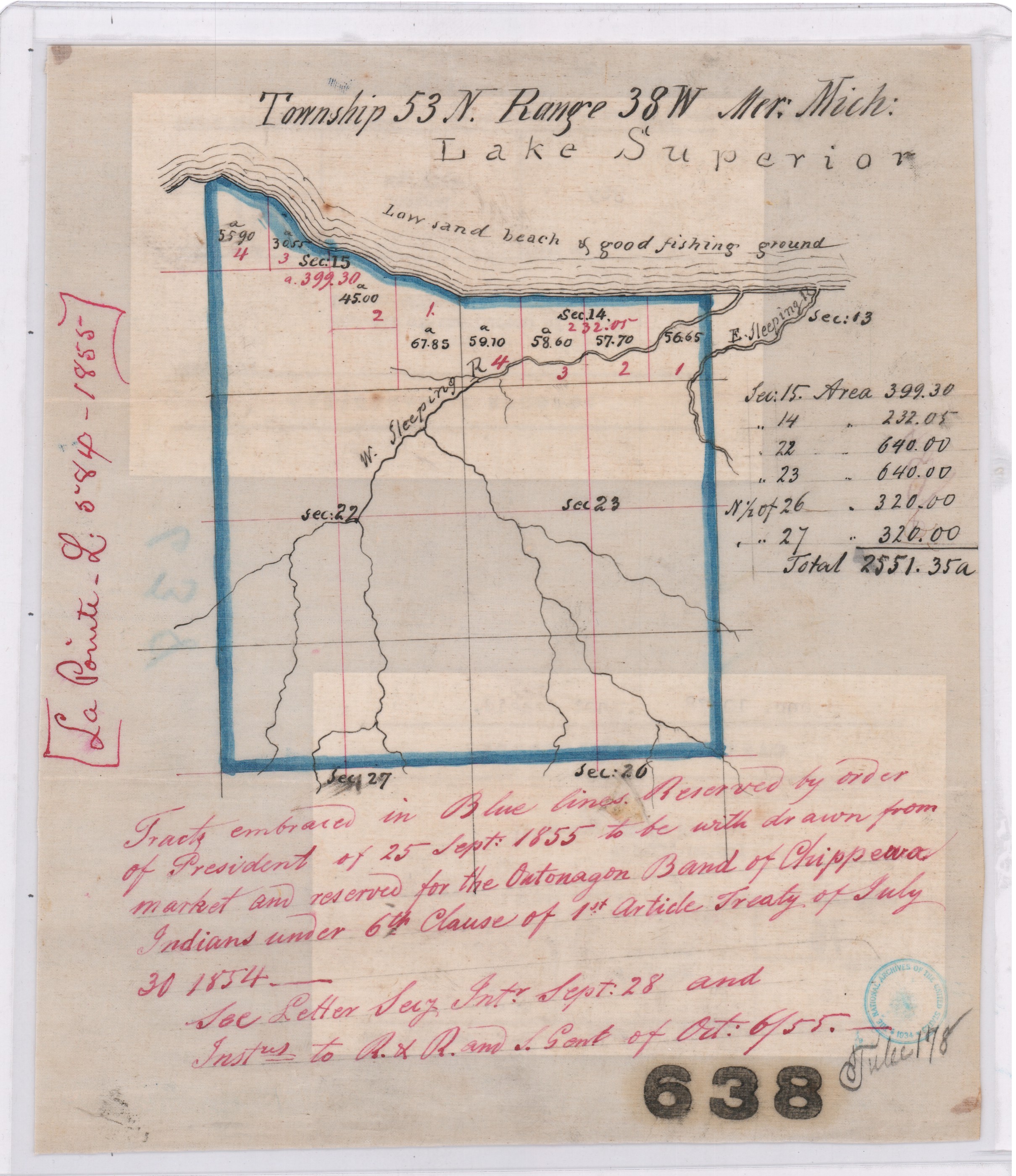
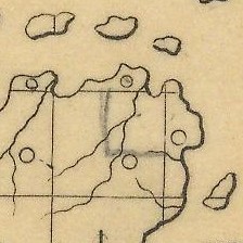
Map of “Tract embraced in blue lines reserved by order of President of 25 September 1855 to be withdrawn from market and reserved for the Ontonagon Band of Chippewa Indians“ on a “low sand beach & good fishing ground”.
Central Map File No. 638 (Tube No. 138)
NAID: 232923886 cites “La Pointe L.584-1855”.
The Ontonagon Band and Chief Buffalo’s Subdivision of the La Pointe Band got lumped together in this clause, so let’s review the Ontonagon Band first. Less than one year after the 1854 Treaty, the Ontonagon Band selected four square miles for their Reservation as approved by President Franklin Pierce’s Executive Order of September 25, 1855. Today the Ontonagon Band Reservation still has its original shape and size from 1855 despite heavy “checkerboarding” of its landownership over time.
In comparison to the Ontonagon Band Reservation, the history of how Chief Buffalo’s Reservation got selected is not so straightforward. Despite resisting and surviving the Sandy Lake Tragedy and Ojibwe Removal, making an epic trip to meet the President at Washington D.C., and securing Reservations as permanent homelands for the Chippewa Bands in the 1854 Treaty, Chief Buffalo of La Pointe died in 1855 before being able to select four square miles for his Subdivsion of the La Pointe Bands.
Fortunately, President Franklin Pierce’s Executive Order of February 21, 1856 withheld twenty-two square miles of land near the Apostle Islands from federal public land sales, allowing Chief Buffalo’s Estate to select four of those twenty-two square miles for their Reservation without competition from squatters and other land speculators, while other prime real estate in the ceded territory of La Pointe County was being surveyed and sold to private landowners by the United States General Land Office.
This 1856 Reservation of twenty-two square miles for Chief Buffalo’s Estate set the stage for what would eventually become the Red Cliff Reservation. We will return to this 1856 Reservation for Chief Buffalo’s Estate in several upcoming posts exploring more records about Red Cliff and the other La Pointe Band Reservations.

Maps marked “A” showing certain lands reserved by the 1854 Treaty:
Central Map File No. 793 (Tube 446)
NAID: 232924228 cites “La Pointe L.579-1855″.
Central Map File No. 816 (Tube 298)
NAIDs: 232924272 & 50926136 cites “Res. Chippewa L.516-1855”.

1878 Copy of President Franklin Pierce’s Executive Order of February 26, 1856 for Chief Buffalo’s Subdivision (aka “Red Cliff”).
NAID: 117092990
Office of Indian Affairs.
(Miscellaneous)
L.801.17.1878
Copy of Ex. Order of Feby. 21. 1856.
Chippewas (Red Cliff.)
Wisconsin.
Enc. in G.L.O. letter of Nov 23, 1878 (above file mark.)
in answer to office letter of Nov. 18, 1878.
Ex. Order File.

Secretary of the Interior
Robert McClelland
Department of the Interior
February 21, 1856
Sir,
I herewith return the diagram enclosed in your letter of the 20th inst, covering duplicates of documents which accompanied your letter of the 6th Sept. last, as well as a copy of the latter, the originals of which were submitted to the President in letter from the Department of the 8th Sept. last and cannot now be found.
You will find endorsements on said diagram explanatory of the case and an order of the President of this date for the withdrawal of the land in question for Indian purposes as recommended.
Respectfully
Your obt. Servt
R McClelland
Secretary
To
Hon Thos A Hendrick
Commissioner of the
General Land Office
(Copy)
General Land Office
September 6, 1855
Hon R. McClelland
Sec. of Interior
Sir:
Enclosed I have the honor to submit an abstract from the Acting Commissioner of Indian Affairs letter of the 5th instant, requesting the withdrawal of certain lands for the Chippewa Indians in Wisconsin, under the Treaty of September 30th, 1854, referred by the Department to this office on the 5th. instant, with orders to take immediate steps for the withdrawal of the lands from sale.
Detail of 1856 Reservation in pencil on “a map marked A.“
Central Map File No. 816 (Tube 298)
NAIDs: 232924272 & 50926136 cites “Res. Chippewa L.516-1855”.
In obedience to the above order I herewith enclose a map marked A. Showing by the blue shades thereon, the Townships and parts of Townships desired to be reserved, no portion of which are yet in market, to wit:
Township 51 N. of Range 3 West 4th Prin. Mer. Wis.
N.E. ¼ of Town 51 N ” 4 ” ” ” “.
Township 52 ” ” 3 & 4 ” ” ” “.
For the reservation of which, until the contemplated Selections under the 6th Clause of the Chippewa Treaty of 30th September 1854 can be made, I respectfully recommend that the order of the President may be obtained.
The requisite reports on the subject of the new surveys, and respecting preemption claims, referred to in the same order, will be prepared and communicated at an early day.
I am respectfully
Your Ob’t Serv’t
Thos. A. Hendricks
Commissioner
Department of the Interior
Feb. 20. 1856
Detail of 1856 Reservation in blue on “duplicate of the original“.
NAID: 117092990
This plat represents by the blue shade, certain land to be withdrawn with a view to a reservation, under Chippewa Treaty of 30 Sept 1854, and as more particularly described in Commissioner of the General Land Office in letter of 6th Sept 1855. The subject was referred to the President for his sanction of the recommendation made in Secretary’s letter of 8th Sept 1855 and the original papers cannot now be found. This is a duplicate of the original, received in letter of Comm’r of the General Land Office of this date and is recommended to the President for his sanction of the withdrawal desired.
R. McClelland
Secretary

1856 Reservation in red and modern Red Cliff in brown. Although different in shape, both are roughly twenty-two square miles in size.
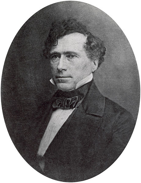
14th United States President
Franklin Pierce
February 21st 1856
Let the withdrawal be made as recommended.
Franklin Pierce
Penokee Mixed-Blood Allotments Shakedown Scam of 1858
April 21, 2018
By Amorin Mello
This is one of several posts on Chequamegon History featuring the Mixed-Blood Allotments of the Penokee Mountains overlooking Chequamegon Bay, such as the Sioux Scrip scams during the Penokee Survey Incidents. This post illustrates the curious circumstances that occurred at the U.S. General Land Office in the City of Superior during 1858 as a large group of Chippewa Mixed-Blood Allotments were located along the Penokee Mountains via the seventh clause of the second article of the 1854 Treaty of La Pointe:
ARTICLE 2.
The United States agree to set apart and withhold from sale, for the use of the Chippewas of Lake Superior, the following-described tracts of land, viz:
[…]
7th. Each head of a family, or single person over twenty-one years of age at the present time of the mixed bloods, belonging to the Chippewas of Lake Superior, shall be entitled to eighty acres of land, to be selected by them under the direction of the President, and which shall be secured to them by patent in the usual form.
Selected affidavits from the National Archives:
Interior Department appointment papers, 1849-1907.
Roll 6, Superior Land Office 1854-1860.
May 1, 1858
State of Wisconsin
County of Douglas
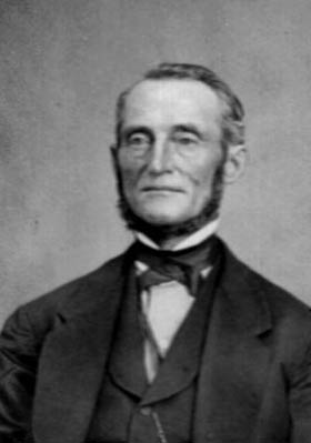
John Dow Howard (photograph from the Duluth Public Library) later owned large areas of land in both Superior and Duluth.
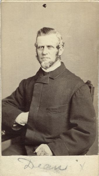
Eliab Byram Dean, Jr. (photo from Wisconsin Historical Society) was a Madison businessman and Wisconsin State Senator.
John D. Howard being duly sworn says, that he resides in Superior, Douglas County, Wisconsin, and that he is acquainted with Eliab B. Dean Jr, the Receiver of the U. S. Land office at Superior aforesaid; that sometime during the month of January or February 1858 the said Dean stated to affiant that he said Dean had an object in view whereby an investment could be made at a profitable rate, and if affiant could command the sum of one thousand or fifteen hundred dollars, he said Dean would give the affiant a proportion of the profits that might accrue therefrom, representing to the affiant that it was a matter he did not feel disposed to disclose fully the substance of [tile?] a future period, and that in the mean time affiant should follow his, Dean’s, instructions to -not- provide means to purchase Half-Breed Scrip and hold his Dean’s proportion secretly – saying he Dean did not wish to be known in the transaction. Subsequently, affiant was informed by Dean that the Half Breed Scrip was to be laid by affiant under power of attorney from Half-Breeds on lands in the Superior Land District, known as the “Iron Range” near Ashland, which lands had been filed upon by settlers under a pre-emption law of the United States that said Dean showed the affiant a list of the persons claiming the said land by pre emption which list was contained in the Register’s abstract of Declaratory statements, and told the affiant that these were the land he proposed to enter with the said scrip. For the purpose of enabling affiant to purchase genuine scrip the said Dean showed to affiant an official list of the Half-Breeds who were entitled to receive scrip from the Government. In this arrangement Dean proposed to affiant that he Dean and affiant should enter into a combination to contest the right to the land with the pre-emption. The said Dean further informed affiant that he had secured such influence at Washington that beyond a doubt he and affiant would be able to secure the land. And the said Dean wished affiant to keep Dean’s interest in the location of the Scrip a secret; and to do all the business in affiant’s name and after the title of the lands was secured, affiant was to convey to Dean, or for Dean’s benefit such portion of the lands as Dean by the agreement should be entitled to.

Ad from the Superior Chronicle, July 10, 1855.
And this affiant further says that said arrangement was not consummated in consequence of affiant’s determination not to purchase the scrip, and further says not.
J. D. Howard
Sworn to & subscribed before me this 1st day of May A.D. 1858
Geo. W. Perry
Notary Public
Douglas County
May 2 1858
State of Wisconsin
County of Douglas

Julius Austrian (photo from the Madeline Island Museum) was accused of obtaining fraudulent power-of-attorney over Chippewa Mixed-Bloods as the U.S. Postmaster at La Pointe.
“I think I have told you that E. B. Dean is removed. For this we must thank Austrian. The Com. gave him 30 days in which to answer the charge against him, and he was round here a long time trying to get Austrian to retract and even offered him $2000.00 to clear him but no go The Jew was determined to have his revenge.”
Julius Austrian being duly sworn says that he resides in the County of LaPointe, Wisconsin and that he is acquainted with Eliab B. Dean Jr Receiver of the U. S. Land Office at Superior Wisconsin; that on the first day of March A.D. 1858, this affiant applied at said Land Office to locate certain Chippewa Half Breed Scrip, under Power of Attorney to this affiant from the Half Breeds to whom said Scrip was issued, that the application of this affiant under such Power of Attorney was made in due and proper form, and signed by the Register of said Land Office, who told and that this affiant requested the Receiver (the said Dean) to sign the same, but that said Dean delayed signing the same, and would not talk with the affiant in the Land Office, but compelled this affiant to meet him said Dean at various places under various pretexts, until finally the said Dean told this affiant that he (Dean) would not sign the said applications unless this affiant should first pay him (the said Dean) the sum of Five hundred Dollars, and that this affiant being pressed for time and anxious to perfect the location of the said Scrip, after some demur, paid to the said Dean the said sum of $500.00 so demanded to the said Land Office, and signed the said applications as Receiver of said Land Office.
Julius Austrian
Sworn and subscribed before me
this 2nd day of May A.D. 1858
Geo. W. Perry
Notary Public
Douglas County
General Land Office
May 21, 1858
Sir,
Land Office Frauds
“If Congress would amuse their leisure a little by looking at these land office operations on the verge of civilization, they would strike a placer of corruption. […] Let them find out what Receiver DEAN said of Register SHAW, and what Register SHAW said of Receiver DEAN, and why DEAN was dismissed and why SHAW was retained. It will be rare fun for somebody. The country ought to know something about the Land Offices, and such an investigation as this would enlighten the country very materially. I hope it will be made, and that the country will learn how it is that more land has been entered in this district by Indians, foreigners, and minors than by qualified preëmptors, and all for the benefit of a few favored speculators.”
I have the honor to submit herewith a letter from Daniel Shaw Esq.~ Register at Superior Wisconsin, covering charges against E. B. Dean Jr., Receiver at that place, as follows:
1) Refusing to sign an application of Julius Austrian to locate certain Half breed scrip, under power of Attorney, said Dean refused to sign the applications unless Austrian paid $500, after some demur A. paid the $500 and Dean signed the papers in his official capacity as Receiver.
2) Agreeing to permit one Honsinger, for a consideration, to enter the pre-emption claim of a man named Cotas advising Honsinger what means to take to enter Cotas claim; these measures however were defeated by the Register.
3) Making an agreement with Jas. D. Ray, to purchase land of a pre-emption after he had proved up, and furnishing funds from the public safe to pay for the land so purchased.
4) Proposing to John D. Howard, a secret partnership for the purpose of speculating in half breed Scrip, and entering lands therewith, which Lands had been filed upon by settlers under the pre-emption law. Dean exhibited to Howard a list of persons claiming these lands, also exhibiting the Official list of half breeds; which list this Office directed should be kept confidentially from all persons.
Superior, Wisconsin
May 22, 1859
Sir;
You will oblige me by informing me whether my removal from the Office of Register at this place was in consequence of any charges [referred?] against me; and, if so; whether it appears from the record that I have have an opportunity for defence.
Very Respectfully
Your Obt. Servt,
Daniel Shaw.
Hon. Thos. A. Hendricks,
Comr. Genl. Land Office,
Washington, D.C.
Edwin Ellis Incidents: Number II
March 26, 2017
By Amorin Mello

Originally published in the June 30th, 1877, issue of The Ashland Press. Transcribed with permission from Ashland Narratives by K. Wallin and published in 2013 by Straddle Creek Co.
… continued from Number I.
EARLY RECOLLECTIONS OF ASHLAND.
“OF WHICH I WAS A PART.”
Number II
My Dear Press: – At the close of my last scribblings, we had arrived on the present site of Ashland, near where the railroad dock reaches the shore and were sheltered in a log shanty, built by Lusk, Prentice & Co., a kind of land company who had plans of starting a town here, of building a dock, and who had a small stock of merchandise and provisions to aid in their proposed work. The members of the firm were David S. Lusk, of New York, Frederick Prentice, of Toledo, Ohio, Capt. J. D. Angus, of Ontonagon, and Geo. R. Stuntz, then of Superior City.
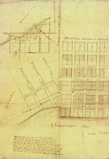
1850s survey of Frederick Prentice Addition of Ashland at/near the ancient village site of Gichi-wiikwedong. “It is in this addition, that, the Chippewa River and the St. Croix Indian trails reach the Bay.”
~ Wisconsin Historical Society
Mr. Lusk left the lake in 1856, and I think died some years since in California.

Frederick Prentice
~ History of the Maumee Valley by Horace S Knapp, 1872, pages 560-562.
Mr. Prentice, a man of great energy and business enterprise, now resides in Toledo, and is largely engaged in the production and refining of coal oil, being one of the great operators in that enlightening civilizer. He has accumulated an ample fortune, and is still largely interested in real estate in our town and country.

Captain John Daniel Angus
~ Madeline Island Museum
Capt. J. D. Angus, and old salt, familiar with all the oceans as well as our inland seas – having circumnavigated the globe; able to build any water craft from a Mackinaw boat to a ship of war; a man with an exhaustless store of anecdotes; who was acquainted with “Sinbad, the Sailor” – having passed through many vicissitudes- is now living in our country, full of life and activity.

George Riley Stuntz
~ The Eye of the North-west: First Annual Report of the Statistician of Superior, Wisconsin, by Frank Abial Flower, 1890, page 26.
George R. Stuntz now resides in Duluth, a civil engineer by profession, who came to the west end of the lake thirty year ago; who has done more surveying of government land than any other man on the lake. He is a descendant from the third generation of a Hessian soldier, hired by George III to fight against the American Colonies in the war of our Revolution; but who after fighting one battle on the side of the Despot, was convinced of the wrong of the British cause, became an active rebel and a sincere defender of American liberty. He and his children and children’s children have ever been true American patriots, and have done good service to the cause of the Republic. He is the owner of much real estate on Lake Superior, in both Wisconsin and Minnesota.
These men had also been attracted by the situation of our bay as the outlet of an extensive country, abounding in minerals and timber. They had perfected no plans for the acquisition of title to the land. It is true several claims had been made reaching from Fish Creek nearly to the Indian Reserve – a narrow strip on the bay, but the claimants gained no rights thereby, for the lands had not been surveyed, and we were all in the eye of the law, trespassers. The Land Office, which was then at Hudson, on the St. Croix river, was not allowed to receive and entertain declaratory pre-emption statements.
Still Lusk, Prentice & Co. were even then engaged in building a dock and clearing off the site of an expected city, to which even then they gave the name of “Bay City” – by which name the larger part of the present site of Ashland was known for many years. It is now in legal description as “Ellis Division of Ashland.” The timber was cut into cord wood and piled upon the dock, in anticipation of the wants of the numerous steamboats soon expected to throng the docks of the rising city.
Some twenty acres of land were thus cut over, reaching from near Dr. Ellis’ present residence to the Bay City creek, and from the bay shore nearly back to the Railroad depot.
The dock extended from the low point about a hundred yards east of the Door and Sash Factory of White & Perinier, about five hundred feet into the water, and reaching a depth of about eleven feet. It was made of cribs of round logs, pinned together with wooden pins. The cribs were about 25×30 feet, and about 25 feet apart. They had no filling of any kind. They were connected with stringers, which served as the foundation of the road-way, made by laying round poles crosswise upon the stringers.
It may seem stranger to us with the results of many years’ observation and experience of the force of waves and currents and ice pressure in the bay, that such a dock should ever have been built. But hind sight is always clearer than fore sight, and recent dock builders have had the benefit of the costly experience of the pioneers.
They labored under the impression that the ice melted in the bay and did not move out in large fields. They soon had this error corrected. On the last day of March, 1855, the ice in Ashland bay was broken for two or three hundred feet from shore only the body of the ice had not moved, and gave no signs of moving. It looked as though it might remain for weeks. The morning sun of April 1st shone upon the smooth, classy surface of the water. The ice had disappeared in a single night, and the dock and wood piled upon it – the result of so many hard days’ work – had passed away also. The remains might be seen for many years scattered along the bay shore and far up the Kau-kau-gon. The present dwellers here can hardly realize the depressing effect of this loss to the little squad of settlers.
To be continued in Number III…
By Amorin Mello
A curious series of correspondences from “Morgan”
… continued from Saint Croix Falls.

The Daily Union (Washington D.C.)
“Liberty, The Union, And The Constitution.”
July 31, 1845.
To the Editor of the Union:

Andrew Belcher Gray published the Map of the Mineral Lands Upon Lake Superior Ceded to the United States by the Treaty of 1842 With the Chippeway Indians in 1845.
~ Wisconsin Historical Society
SIR: In your paper of Tuesday evening, I have observed a communication from Copper Harbor, (Lake Superior,) so pregnant with errors or misrepresentations, that I am constrained, by a regard to truth and the public interests, to ask the use of your columns to correct some of them. I know not who your correspondent is; but, judging from the extraordinary zeal with which he labors to forestall public opinion of certain government agents on Lake Superior, whose conduct has recently become obnoxious to very grave suspicion, I think it no unwarrantable conclusion that he has either been most egregiously imposed upon, or that he is animated in his encomiums upon the officers alluded to, by motives much more special than in his admiring comments upon the handsome scenery and novel life upon the lake. He is evidently more than indifferently anxious to vindicate and extol General Stockton and his faithful deputy, Mr. Gray. Otherwise, what necessity would there be for asserting facts which do not exist? Your correspondent states that
“The only tenement on the island is a miserable log-cabin, in which General Stockton, for the want of better quarters, is compelled to keep his office. The room which he occupies, is only about eight feet square – just large enough to admit a narrow bed for himself, a table, and two or three chairs. In this salt-box of a room, he is compelled to transact all the business relating to the mineral lands embraced within this important agency. As many as a dozen men at a time are pressing forward to his ‘bee gum’ apartment, endeavoring to have their business transacted.
“The office of the surveyor of this mineral lands, in charge of Mr. Gray, at this agency, is still worse adapted to the transaction of public business. He is compelled to occupy the garret of the log-cabin,” &c.
Now, so far from this being true, “the miserable log cabin” of which your fastidious correspondent speaks, is an excellent hewed log house, well finished and ceiled, with three good-sized rooms below, and three above stairs, amply sufficient and convenient for all intended purposes. The construction of this house cost the government some fifteen hundred dollars, and was designed as the agency-house; whereas General Stockton has converted it into a sort of hotel – doubtless as a means of augmenting the perquisites of his station. Hence he has stinted himself, and the convenience of the government service, to his “bee-gum” and “salt-box” penetralia of “eight feet square.” So much for this misrepresentation.

Painting of Professor Douglass Houghton by Robert Thom. Houghton first explored the south shore of Lake Superior in 1840. Houghton died on Lake Superior during a storm on October 13, 1845. The City of Houghton on Chequamegon Bay was named in his honor, and is now known as the Houghton Falls State Natural Area.
Your correspondent expresses a like sympathy for the privations and long-suffering of Mr. Surveyor Gray. The apartment which Mr. Gray occupies above stairs, is an ample room, some fifteen or more feet square, and is quote comfortable – nay, quite luxurious quarters, when compared to those of the other surveyors, who are where Mr. Surveyor Gray should be, if he was faithfully discharging his duties – out in the woods and the weather, among the rocks and swamps, driving the compass and chain through almost impenetrable wilds. It may, perhaps, be a question with the government, as it certainly will be with the public, why Mr. Gray should be lolling at his ease in the agency-house on Porter’s island, while Dr. Houghton, the other surveyor, is traversing large tracts of the mineral lands, and sustaining all the hardships and perils which pertain to his employment? And it may become a further question, while I am on this head, why Mr. Gray, who was an unrelenting tool of the whig party, and neglected the public service, for which he was receiving a handsome salary, last year, to mingle in the orgies of federal-Clay-clubites, should not only be so sedulously retained in office, but be admitted to the privilege of almost total exemption from labor, which he is employed and paid to perform? It is a fact, that up to the 3d of July, Mr. Gray had surveyed only two miles, whereas Dr. Houghton had measured some five hundred miles of the mineral lands! And this is the gentleman against whose discomfort your correspondent so pathetically appeals, forsooth, because he is occupying at his ease an excellent apartment in a very comfortable house.
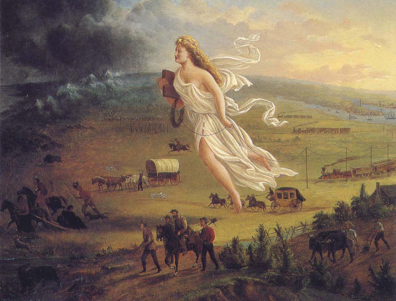
American Progress by John Gast, 1872
“This painting shows ‘Manifest Destiny’ (the belief that the United States should expand from the Atlantic to the Pacific Ocean. In 1872 artist John Gast painted a popular scene of people moving west that captured the view of Americans at the time. Called ‘Spirit of the Frontier’ and widely distributed as an engraving portrayed settlers moving west, guided and protected by Columbia (who represents America and is dressed in a Roman toga to represent classical republicanism) and aided by technology (railways, telegraph), driving Native Americans and bison into obscurity. It is also important to note that Columbia is bringing the ‘light’ as witnessed on the eastern side of the painting as she travels towards the ‘darkened’ west.”
~ Commons.Wikimedia.org
The design of this letter from Copper Harbor is perfectly apparent to me. It is the sequel to a movement which was made last June, viz: to white-wash and to shield from a just reprehension the present superintendent of the Lake Superior mineral lands. On the very day that General Stockton opened his office, a sort of soi-disant public meeting was gotten up there, in compliment to the General, in which the president of the New York and Lake Superior Mining Company was the prime mover. When it is known that General Stockton has certified to the Ordnance Department locations by this company of between one and three hundred square miles, upon which leases were granted, when not a single foot had been actually located, in flagrant violation of all the laws and regulations, some opinion may be formed of the secret of this most disinterested and valuable tribute to the official worth of this superintendent. What might have been the potency of this expression of public opinion (!) in protecting Gen. Stockton’s official conduct from censure and investigation up to the period of its dispensation, I will not now say. But, certain it is, that large and glaring spots which have begun to attract scrutiny and invoke exposure, have rendered his escutcheon needful of a new coat of white-washing; and hence this effort of your correspondent to forestall examination into his conduct, by pathetic epics of his patiently-endured privations iin the public service, and the ignorant or else sinister commendations of his conduct.
In animadverting upon the conduct of General Stockton and others, I do not mean to include Major Campbell, of whom everything that your correspondent has said is hereby confirmed.
POSTEA PLUS.
———

William Learned Marcy was the 20th United States Secretary of War during Polk’s presidency.
~ Wikipedia.org
We have omitted a large portion of the above communication, in which the writer proceeds to complain of the survey of the mineral lands, and arraigns the agents of the government for gross malversation in office. These charges are of a serious character, and they demand a full and rigid investigation. But, as it might lead to a protracted and angry war in the papers, in which crimination would be followed by recrimination; and as we are advised that the Secretary of War is determined to investigate the justice of these complaints and the truth of them – as he will receive any specifications in writing which may be submitted, and is determined to go to the bottom of the subject; and, with that view, will appoint a commission of two of the most respectable gentlemen he can obtain, who will go upon the lands, and probe everything for themselves, – we have thought it best to let matters take that turn. We have not the slightest doubt that the attention of the department is thoroughly exited to the importance of the duties which may devolve upon it, and that it will unquestionably discharge them. It is scarcely necessary, therefore, for the press to mingle at present in a discussion, which might occupy much space, lead to much excitement, and, after all, fail to lead to the best and wisest results.
– UNION.

The Daily Union (Washington D.C.)
“Liberty, The Union, And The Constitution.”
August 1, 1845.
THE COPPER REGION.

James Knox Polk:
11th President of the United States.
~ Wikipedia.org
We have been inconsiderately drawn into a subject of some importance to the United Sates. We have struck a vein, however, which promises to be rich in its resources. The reader will recollect a very long and interesting letter which we published on Tuesday evening, from one of our regular correspondents, who is now on a trip from New York to Lake Superior, in which he gave us a description of its peculiar and striking scenery, and made some remarks upon the copper lands in its vicinity, and upon the agents of the United States who have been charged with the care of the mineral lands belonging to the government. This letter drew forth a reply in our last evening’s paper; but we declined the publication of the whole communication, for the reasons which we then stated. The writer of that article charged the United States agent with many acts of mismanagement, and even malversation of office; and as we were aware that our government was about to appoint a commission to visit the country, and investigate the conduct of the agents, we deemed it most advisable to refer to another tribunal, (for the present, at least,) a full inquiry into these matters. In the mean time, a new scene was opened before us. We were scarcely aware of the existence of these mineral resources, – much less of their extent. But our curiosity is now being aroused. The public documents connected with them have been politely placed in our possession, and we shall prepare an article for the “Union” for the purpose of calling the attention of the country to this very interesting subject. The lead-mines belonging to the United States in Wisconsin, Illinois, Iowa, &c., have been longer known and are better understood than the copper region. They have been worked to a considerable extent, and their produce is so abundant, that they can not only supply our own market with lead, but afford a large export for the consumption of foreign nations. Perhaps no mines in the world are equal to those of the belt on both sides of the Mississippi.
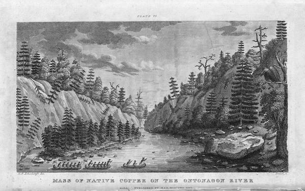
Engraving depicting the 1820 Cass/Schoolcraft expedition crossing the Ontonagon River to investigate the famous copper boulder.
~ Wisconsin Historical Society
The purchase of this rock from the Chippewa Indians was made in 1841. The treaty with these Indians, ceding this portion of the country to the United States, was not made until October, 1842, after the second expedition to that country for the purpose of removing this rock. The Indians say that they did [not] reserve this rock in the treaty of 1842, as they had already sold it to a citizen of the United States, and they conceived that they had no further control over it. They say that, by their treaty, they only sold their lands, and suppose that all moveable property of this kind, which had been previously the subject of individual negotiation, would be allowed to be removed by the individuals making the purchase of them, as readily as they would be allowed to remove their lodges or canoes.
J. ELDRED, for self and sons.“
~ Public Documents Printed by Order of the Senate of the United States: First Session of the Twenty-Eigth Congress, 1844.

The Ontonagon Copper Boulder at the Smithsonian Institution National Museum of Natural History. Photograph by Ian Shackleford, 2011; shared with a Creative Commons license.
~ Wikipedia.org
The copper region is probably more important than the lead-mines. It is supposed by some geologists to extend from Lake Superior to Texas, crossing the Mississippi diagonally at a lower point than the lead-mines, and forming a vein of from thirty to forty miles of average width. The ore is said to be unusually rich. In some places it is mixed with veins of silver, so abundant that the precious metal alone is sufficient to pay all the expenses of working the vein – the ore itself making a yield of 60 or 70 per cent. of copper. An immense boulder of this metal is now deposited in the public yard between the War and Navy Departments, and is well worthy the inspection of all curious observers who happen to visit Washington. It weighs more than 3,700 lbs., and is so rich in the metal that a plate of copper is smoothed off on its surface like the copper-plate of the engraver. It was transported to Washington from the banks of the Ontonagon river, about forty miles from the Eagle river. The two principal points where the richest ore has yet been developed, are on Eagle river, and near Copper Harbor, on Lake Superior. But the richest portion of the copper region, as far as it is explored, is reputed to be Isle Royale, in Lake Superior, much nearer the Canada side than our own; but the boundary line runs north of the island, so that it falls within the limits of the United States. Isle Royale is estimated to be about thirty miles in length, and five miles broad – singularly rich in copper, which is constantly cropping out on the surface. The department has decided that no patents should be granted, and no leases taken, on this singular island.
Two large companies have been formed for leasing and working the mines in the Lake Superior Copper Region – the one which operates in New York, and the other in Boston. So valuable have shares become in some cases, that a gentleman in Boston, who is said to own about eighty shares, has been offered more than $600 for a single share. The supervision of these mines is devolved on the Ordnance Bureau, (Col. Talcott,) attached, of course to the War Department. Some important regulations have been made about the leasing of the mines, but further legislation will be required from Congress. The Secretary of War grants the permits to applicants to go upon the lands; and upon presenting a certificate from the agent of the United States that the tract has not been previously occupied, a lease may be granted for three years, upon condition of paying 6 per cent. of the nett proceeds of the metal, after it is smelted from the ore. If the lease be renewed for another three years, the rent is extended to 10 per cent. The leaseholders were originally confined to the smelting of the ore in the neighborhood of the mines; but it was found that, owing to the want of fuel, and other appliances, it was best to transport the ore to New York or Boston. The secretary yielded at last to the application – the government still receiving its 6 per cent. of rent, in the metal itself, free of all expense of transportation.
On the 21st of March last, it was determined by the Secretary of War to grant no more permits which would authorize a selection of more than one square mile; and between that time and 18th ult., seven hundred and sixty such permits were issued. It was then determined to stop the further issue. The cause of this is expressed in the printed circular from the Secretary of War, which we have already published. It states that,
“should locations be made pursuant to the permits already issued from this department, to select lands in the Lake Superior mineral district, the quantity required to satisfy them would exceed one million one hundred thousand acres It is apprehended that the whole region open for lation may not contain this quantity of mineral lands. Explorations and surveys of these lands have been ordered, and it has been determined to suspend the further issue of permits until the results shall be made known. The applications for permits received at the department subsequent to the 17th instant, will be filed in the office; and if the disclosures of the examinations shall warrant the further issue of permits for the Lake Superior region, they will be considered in the order in which they have been or shall be received. It is not expected that the results of the examinations and surveys to ascertain the probable quantity of mineral lands in the region, and to make the locations pursuant to the permits already issued, can be completed for some time to come.”
This is to certify, that on the 1st day of September last, while attending the payment of the Chippewa Indians at Lapointe, Lake Superior, Okondókon, being the head chief of the band of that tribe, and who resided at the mouth of the Ontonagon River, state, in my presence, that he had sold to Julius Eldred, of Detroit, in the summer of 1841, the celebrated copper rock; and that he had received, at the time of the sale, a portion of the sum agreed upo, and that there remained due him one hundred and five dollars, which was to be paid him whenever Mr. Eldred removed the rock to the shore of the lake; which sum of one hundred and five dollars Mr. Eldred did pay to Okondókon a few days thereafter, at the Ontonagon agency, in pursuace of the agreement made between them in 1841.
I further certify, that, on the 10th day of September last, Julius Eldred paid to Messrs. Hammond & Co. seventeen hundred and sixty-five dollars, for the services which they rendered in removing the rock, as well as to obtain peaceable possession of the same.
The removal of this copper rock has been attended with very great risk as well as expense, and is one of the most extraordinary performances of the age, and one which, in my opinion, should entitle him to great praise as well as liberal compensation.
WALTER CUNNINGHAM.“
~ Public Documents Printed by Order of the Senate of the United States: First Session of the Twenty-Eigth Congress, 1844.
It seems that Walter Cunningham, the first superintendent of these lands, kept no record of the permits he granted, or of the selection of tracts to which he certified as not interfering with the claims of others; and, in consequence of the absence of this information, it appears that his successor (Stockton) has, in two or three instances, certified for others, tracts previously certified by Mr. Cunningham; and this has given rise, as may be supposed, to some complaint. The certificates of the latter have been dropping in for a week or two past, but we know that very few or more can be in existence.
Mr. Gray (the only one of the assistants assigned to the superintendent, who possessed any competent knowledge of the surveying or platting) has been busily engaged in preparing maps, and locating the leases, and claims to leases thereon, to save from the risk of granting certificates which will interfere; and another competent surveyor has recently been sent to that country, in order that the operations may be expedited as fast as possible. It is also understood that Dr. Houghton is carrying on surveys under the orders of the General Land Office, which will soon extend into Stockton’s district, and will probably throw much additional light upon the extent of this interesting region of country.
We are informed that, as regards Mr. Gray’s mingling in any way with politicians, (as was stated by our correspondent of last evening,) it can scarcely be true. “He is a young man, who has been constantly moving about, and acquired no right to give a vote in any location. Modest and retiring, he is the last man in the world to do anything of the kind charged upon him.”
It will be seen, from this very rapid sketch, on imperfect data, that the copper region of the United States abounds with interest; that, from the abundance and the richness of the ore, it is probably calculated to furnish copper enough for our own consumption, and for a large exportation to foreign countries. Of course, great interests are growing up in that wonderful region – much speculation, large companies, strong contests for the possession of the titles – the same mine sometimes shingled over with several claims – some violence and some fraud. And even the agents of the government have not escaped the suspicion of mismanagement and malversation. The executive is about to do its duty in these respects. It is contemplated to employ two highly respectable commissioners to inspect the lands, to receive and investigate all complaints, and make a report to the War Department. A more complete report also, of the mineral resources of the West, the quality and extent of the mines, and the best way of working them, will probably be obtained, under the auspices of the vigilant Secretary of War, to be submitted to the next Congress. The statistics will, no doubt, be found valuable; and, in fact, the whole subject is every day assuming a new and a more expanding interest.
Two additional articles were published by The Daily Union on August 2 and August 11 regarding the Copper Region. They include extensive quotes from United States government agents involved in surveying the Copper Region, but are not directly related to the correspondences of “Morgan” or his accuser “Postea Plus” and therefore are not reproduced here on Chequamegon History.
The Daily Union (Washington D.C.)
“Liberty, The Union, And The Constitution.”
August 26, 1845.
[From our regular correspondent.]
GALENA, ILL., August 14, 1845.
Not having time to say more at present about the country through which I passed in coming from the falls of St. Croix to this place, I beg leave to refer to a notice taken of a portion of a letter written by me to the “Union,” from Copper harbor, by some correspondent opposed to Gen. Stockton and Mr. Gray.
It seems that deserved praise bestowed upon these officers of a government has proved offensive to the said correspondent.
I deem his publication worth no other notice than to say, that he speaks falsely and malignantly of “Morgan,” when he attributes his praise of Stockton and Gray to “sinister motives.”
It is known that an attempt was made by members of a certain small band of speculators to locate a mineral lease on a town site at the falls, or Sault St. Marie, where no copper or other mineral has been found, for the purpose of making a speculation of it. And when told by Gen. Stockton that it was not put down in the mineral region, that it was beyond his jurisdiction, and that he could not consent to grant a location for it, they got made, spluttered about their influence at Washington, hinted at his removal, &c. Several other applications were made to him by the same and other parties, equally as absurd and ridiculous, which he had the firmness to deny. Hence, those foiled in using him to suit their own purposes, are most loud in his condemnation. They probably wish some pliant tool to occupy his place.
I am glad to see that a commission is to be appointed to visit Copper harbor, for the purpose of investigating the affairs of the mineral agency. I have no question it is the very thing Gen. Stockton and Mr. Gray themselves would solicit, in the event of charges being made against them, and without the least apprehension as to the result.
I could say more on this subject; but respectfully leave the whole matter in the hands of the government, where it belongs.
I learn from the worthy superintendent of the United States lead-mines at this place, that he thinks the amount of lead shipped from this district the present year will reach 60,000,000 of pounds, which, at 3 cents per pound, would amount to one million eight hundred thousand dollars. The quantity shipped last year was 43,000,000 of pounds.
Galena is growing, and, as a thriving business place, may be considered (of its size) one of the first in the western country; containing, as it does for a new place, an intelligent, active, and enterprising population.
“In the early 1800s Southwestern Wisconsin miners were too busy digging the ‘gray gold’ to build houses. Like badgers, they moved into abandoned mine shafts for shelter. As a result, Wisconsin was nicknamed ‘The Badger State.'”
Wisconsin Historical Society
Wisconsin is a flourishing Territory, and is going to make a splendid State, being rich in mineral, in farming land, and in fine timber, with a plenty of good water, health, &c. Emigrants are pouring into it from all parts of Europe.
Iowa has rejected her constitution, and elected a democratic governor.
I remain yours, very truly and respectfully,
MORGAN.
To be continued in The Upper Mississippi River…
Land Office Frauds
March 25, 2016
By Amorin Mello
New York Times
December 9, 1858
—~~~0~~~—
Land Office Frauds.
—~~~0~~~—
AGRICULTURAL CAPABILITIES HEREABOUT – LOCAL AMUSEMENTS AND EXCITEMENTS – SETTLEMENTS OF SUPERIOR CITY – A CONTROVERSY, AND SECRETARY M’CLELLAND’S ADJUDICATION OF IT – SECRETARY THOMPSON’S REVERSAL OF THAT JUDGEMENT – ITS CONSEQUENCES – LAND-STEALING RAMPANT – INSTRUCTIONS FOR THE ENTRY OF SUPERIOR CITY – THE LAND OFFICE REPEALS THE LAW OF THE LAND – A CASE FOR INVESTIGATION.
Correspondence of the New-York Times.
SUPERIOR CITY, Wis., Thursday, Nov. 25.
I am booked here for another winter, but fortunately with no fear of starvation this time. We have been most successful the last Summer in our Agricultural labors. The clay soils about here has proved marvelously fruitful, and where we expected little or nothing it has turned out huge potatoes that almost dissolve under the steaming process, and open as white as the inside of a cocoa-nut ; mammoth turnips, as good as turnips can be ; cabbages of enormous size ; and cauliflowers, that queen of vegetables, weighing as much as a child a year old. There is no reason to fear for the future of this country, now that we can show such vegetable products, and talk of our gardens as well as of our mines, forests, furs, and fisheries.
We are not without our excitements here, too ; though we have no model artists, or theatrical exhibitions, to treat our friends with. But our little city is now in a state of commotion produced by causes which often agitate frontier life, and sometimes reach the great center with their echo or reverberation. The Land Office is the great point of interest to frontier men, and the land law is the only jurisprudence save Lynch law, in which we are particularly interested. And as we have no means of reaching the great Federal legislature, through our Local Presses, we are always glad of an opportunity to be heard through the Atlantic organs, which are heard all over the country, and strike a note which the wind takes up and carries not only to San Francisco, but up here to the mouth of the St. Louis River, the hereafter great local point of Pacific and Atlantic intercommunication.

The Eye of the Northwest, pg. 8: James Stinson; Benjamin Thompson; W. W. Corcoran; U. S. Senator Robert J Walker; George W Cass; and Horace S Walbridge.
Five or six years ago a few American pioneers – stalwart backwoodsmen, undertook to select a town site out here, and did select one in good faith, and with clubs and muskets in had fought off from their premises a gang of Indians who were claiming to preëmpt it as “American citizens.” The Indians, however, were backup up by a Canadian white man by the name of STINSON, and some of the great speculators who were engaged in another town enterprise alongside here, and this “Indian war” was protracted in the local and general Land Offices some two or three years, when Mr. M’CLELLAND, then Secretary of the Interior, made a final adjudication of all the legal questions involved in the controversy, and sent it back to the Land Office to ascertain and apply the facts to the law as settled, on great deliberation by himself and Mr. CUSHING.
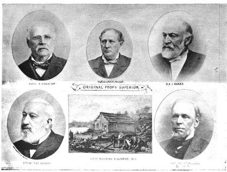
More Proprietors of Superior from The Eye of the North-west
, pg. 9: [names are illegible]
Meanwhile the original settlers and occupants maintained their adverse possession against the Indians and all the world, and expended a good deal of money in erecting buildings and a pier, and in cutting out streets and in laying out their town, and in carrying on their litigation, which was by no means inexpensive. M’CLELLAND’s determination of the law in their favor encouraged them to go on and incur additional expenses ; and they parted with diverse interests in the town site, some by assignment to persons who advanced money, and some by sale on quit-claim to persons who covenanted to make improvements. They made application to the proper office to enter the site, and nobody objected but the Indians – and the Indians were nowhere. So things stood when the case went back to the General Land Office, and to Mr. Secretary THOMPSON. The worthy Secretary, for some cause altogether unaccountable, adopted the extraordinary (and under the decision of the Supreme Court illegal) course of reversing the final judgement of his predecessor in this very case, (an exercise of power entirely unheard of in a case of mere private right,) and of rejecting the claim of the original occupants and settlers, though it was not contested by somebody who had a better right.
You may well imagine that this decision excited no little astonishment here. All the land stealers looked upon Superior City as vacant ground. They thought the men who selected and settled the town site were outlawed, and had no interests. Some supposed that the Land Office would put the ground up at auction. A chap by the name of SWEETZER came on here fresh from the General Land Office, and undertook to lay Sioux scrip on the whole site. Another – one JOHN GRANT – made application to preëmpt a portion of the site – and, what is the most remarkable feature about this business, GRANT was permitted to enter it as a preëmptor, though it was notoriously a selected town site, and in the adverse possession of town claimants half a year before GRANT ever saw it. This outrage created a great excitement for a small place. The Register, Mr. DANIEL SHAW, excuses himself by saying that he was almost expressly ordered by HENDRICKS to issue the certificate to GRANT, but this we do not believe in these parts. SHAW is clever, and covers his tracks, but nobody here supposes that the Commissioner ever countenanced such a gross violation of a public statute, without a motive. And what motive could the Commissioner have?
But, besides these movements, one of the Indians – ROY by name, who was defeated as one of the claimants by preëmeption – is now seeking to locate his Chippewa scrip on the town-site, and it is supposed that the same influences which urged him as an American citizen will support his claim as an Indian. A white man by the name of KINGSBURY, encouraged by the disregard of law exhibited by the local office, has made a claim on another part of the town-site. This purports to have originated in the fourth year of a litigation between the town claimants and the illegal preëmptors, and is supposed to be stimulated and encouraged by the Register.![Vincent Roy, Jr., portrait from "Short biographical sketch of Vincent Roy, [Jr.,]" in Life and Labors of Rt. Rev. Frederic Baraga, by Chrysostom Verwyst, 1900, pages 472-476.](https://chequamegonhistory.com/wp-content/uploads/2016/03/vincent-roy-jr.jpg)
Subsequently to his original rejection of the town-site claim, Mr. Secretary THOMPSON issued instructions to permit the entry, and the County Judge made application on the 18th instant, under the law of the United States, May 23, 1844. On this being known, some of the persons heretofore claiming under the original settlers and occupants (who had selected the town and paid all the expenses of the settlement) came together and formed an organization as a city, under a recent law of Wisconsin, the object of which they declare to be secure to themselves a title from the United States to the lots they specially occupy, and to sell the balance to defray their expenses in entering and alloting the land! The men whose rights vested under the absolute decision of Secretary MCCLELLAND, and who did all that they could do to enter the land, and paid the money for it more than two years ago, – the men whose “respective INTERESTS” the statute of 1844 recognizes and was designed to protect, – these men are all ruled off the course, and the men claiming under them have conspired to divide the land and its proceeds among themselves.
Of course these iniquitous and illegal proceedings are all within the reach of the Courts – but they are the legitimate consequence of Mr. JACOB THOMPSON’s repeal of so much of the Preëmption Law of 1841 as excludes from preëmption those portions of the public lands that have been “selected as the site of a city or town.” Mr. THOMPSON has overruled all his predecessors, all the Attorney-General, all the local offices, all the lexicographers, and the English language generally, by deciding solemnly that “selection” does not mean “selection,” but means something else – or more particularly nothing at all. Because, says he, if adverse “selection” excluded a preëmptor, then a preëmptor might be excluded by a false allegation of selection. Was there ever such an argal since Dogberry’s time? The Secretary has discovered an equally efficient “dispensing power” with that of King JAMES of blessed memory, and one which his brethren in the Cabinet may use very efficiently, if Congress does not look into the subject and fix some limits to it. For now, not only the Secretary, but the Commissioner, and the Register and Receiver, all think that they are at liberty to treat the repeal by the Secretary as an effective nullification of the law of the land.
If Congress would amuse their leisure a little by looking at these land office operations on the verge of civilization, they would strike a placer of corruption. Let them open the books and call for the documents, and see what Dr. T. RUSH SPENSER, late Register of the Willow River District, says of his predecessor and successor, Mr. JOHN O. HENNING, and then ascertain by what influences HENNING has been reappointed, and SPENSER transferred to Superior. Let them find out what Receiver DEAN said of Register SHAW, and what Register SHAW said of Receiver DEAN, and why DEAN was dismissed and why SHAW was retained. It will be rare fun for somebody. The country ought to know something about the Land Offices, and such an investigation as this would enlighten the country very materially. I hope it will be made, and that the country will learn how it is that more land has been entered in this district by Indians, foreigners, and minors than by qualified preëmptors, and all for the benefit of a few favored speculators.
Barber Papers: “The Gardens” Fall of 1856
December 29, 2015
By Amorin Mello
Selected letters of the Joel Allen Barber Papers
… continued from the Summer of 1856.
Lapoint Oct. 12th 1856
Dear Mother
This afternoon I returned from Bad River where I have been attending an Indian payment. Father will tell you all about it. I will only say I had a good time, saw many old friends and made some acquaintances among the government officials that I deem very portinate. I also got a contract from the Indian agent on which I ought to make more than a thousand dollars.
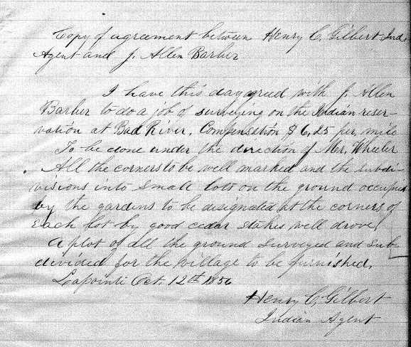
Copy of contract between the LaPointe Indian Agency and Joel Allen Barber to survey the LaPointe Indian Reservation and “the gardens” town-site (Old Odanah), to be done under the direction of Reverend Leonard Wheeler.
~ Board of Commissioners of Public Lands
~ History of Northern Wisconsin, page 64.
I could easily if I had means to carry it on to my liking. It is surveying at $6.25 per mile.
Father has gone to Ironton. I could not go as I wished to stay and conclude my business with the agent.
[You might?] I have been offered $50.00 per share for Ironton I took on which I have only paid 25 dollars per share, but I refused to take it. It may cause you pain to see that I am everyday becoming more and more fastened to this country but I cannot think of deserting it yet. As yet I have not realized one cent for my sojourn in the wilderness but I am far from being discouraged. I have seen fortunes made and have seen men make tens of thousands by taking chances that I might as well have had but I was green and could not read the future.
I am not in a mood for writing my thoughts to you [see rum?] principally upon many matters. Perhaps that is because I have been to payment and and because there is a gambling table in full opperation in the room where I am writing.
It is strange that father never told you the facts in regards to the $600.
There was never any mystery about it to me. Stuntz & Dr. Ellis had the money and returned over $400 of it. It is all right or will be. I nearly forgot to mention that I just got a letter from you to Father of Sept. 25th.
We are both well. Please excuse haste and carelessness.
Your affectionate Son
Allen
[Incomplete copy of letter]
~ Scope and Summary of Joel Allen Barber Papers
There is a young Englishman aboard who has been quite a tourist. He was in the Crimeran? army, went East of there to Ferlizand through Syria to their Holy land to Jerusalem to Egypt the Pyramids the Catacombs. Through all the Country in the South of Europe and northward through Scotland to the [Shetwood Jelas?], has been travelling in the U.S. the past season & is now returning from Superior, got there the day we left [songs her?] visited that poor [Ratefu?] that lost his foot every day till he died. He is a rich land lord & nobleman as I suppose and has a happy way of communicating information upon all subjects especially upon Geology, Mineralogy, Geography [overrated spy?] as well as all other “ologies” He is laying [w/a Speciation?] & [conavasated ??? ??? from?] to England.

1860 photograph of the Paddle Steamboat “Lady Elgin”.
~ Ship-Wrecks.net
The boat has just put to the Canal & [???? ? ????] Do be careful of your life & health and let us hear from you as often as you can.
May God bless and preserve you for many
yearsG. A. Barber
Give my respect to Jo & William.
Interior Field Notes
La Pointe Indian Reservation
Township 47 North, Range 2 West
Notebook ID: [N/a]

Contract awarded by La Pointe Indian Agency to Joel Allen Barber on October 12th, 1856. These survey notes are not available from the General Land Office or the Wisconsin Board of Commissioners of Public Lands.
Lapoint Nov 9th 1856
Dear Mother
I start today for Bad river with four others to commence my job of surveying on the reserve. I am well and in pretty good spirits. Father left on the S.b. Lady Elgin last week.
I am in such a hurry that I can scarcely write legibly. I was elected county Surveyor of this county last Tuesday. My term of office commences Jan 2nd.
I would not like to have this known in Lancaster as it might cause me a little difficulty. I am writing this in a [gragshop?] where there are several men talking so I couldn’t write very sensibly so you must excuse levity. I will write as often as possible but don’t expect me every week as the mails are very irregular and it will be very inconvenient for me to write sometimes. I expect to have a good time this winter. Shall not be far from the very best kind of folks about the Mission and I beg of you don’t grieve because I remain here this winter.
I am very anxious to go home but you see I had something to stay for.
With best love to Am, Aunt Betsy and yourself.
I remain your affectionate Son
Allen
Lapoint Wis. Nov. 9th 1856
Dear Father
Joel Allen Barber;
William W Ward;
Larry Marston;
Joseph Latham.
I expect to get away today for Bad River with one party – Bill & I Larry Marston and Joseph Latham.
I went to Ironton on Saturday before election so I was not there on that interesting day. That mound of earth has scarcely changed at all and will not materially in years. Business is going on pretty well at Ironton. The house is probably up [?? this?].
Joel Allen Barber;
Asaph Whittlesey;
Major McAboy;
[Fremont?];
James Buck;
and others.
The election came off here all right as far as I am concerned. Whittlesey 11 or 12 and McAboy 1. Whole number of votes 108. [Fremont?] got ten votes. The Buck ticket was carried throughout. We only start with one party because no steamboat has come yet and it is doubtful where we shall get a large supply of provisions.
We are all well and prospering. Give my love to all friends in Lancaster
Your affectionate Son
Allen
Excuse haste.
Interior Field Notes
La Pointe Indian Reservation
Township 48 North, Range 2 West
Notebook ID: [N/a]

Contract awarded by La Pointe Indian Agency to Joel Allen Barber on October 12th, 1856. These survey notes are not available from the General Land Office or the Wisconsin Board of Commissioners of Public Lands.
Cambridge Nov 9th 1856
Dear Son.
Now that your father has left you I suppose you will be very glad to hear from Am and me sometimes; at least I hope you have not so much forgotten us that you do not look for a letter whenever the boat arrives and have one prepared to send home by every one. But I forgot that there will be no boats for 5 or 6 long tedious months to come and I fear we shall hear from you but seldom. Let me entreat you to have a letter ready to send to me at least by every visit that leaves your region. I cannot imagine how any one can think of surveying in the deep, dark forest during the winter months to be exposed to storms, day and night without shelter – how you lived do tell me. I am sure no one could live here through the winter in the woods without a pretty warm house and a good fire. Were it not that I know you have had some experience in the business & manner of living I should feel certain you would be frozen or perish in some way. But I suppose you have no such fears.
I have sent 2 or 3 letters for you and father to Lancaster supposing he would be there and hoping you would also. In one I mentioned the happy marriage of M. C. Heath to a most excellent pious young lady who taught school in the village center last summer named Mott. No one suspected his intention – not even his own family till he brought her home and presented her as his wife. Every body is much pleased at the matter.
Mr. J Woodruff has departed this life after lingering and suffering much longer than his friends expected. He tried every possible remedy, but nothing – not even Dr. Hunter’s boasted inhaling method could arrest the fated disease. The latter remedy has been tried in several cases of Consumption in Johnson and equally failed in every case.
You have never said any thing about the trouble in your head and throught since you left home. How is it – does it increase or has that climate proved beneficial in that affliction, as in other respects, to your health?
I am pained to have to announce the death of one more of your dear friends and school mates. Julia Whiting has gone to the spirit world to join the happy throng of the young the beautiful and the good who have passed on before. This is the fourth daughter that afflicted family have been called to mourn – they have but one left. I mentioned the sickness of the rest of the family before – at last Julia was taken unwell with slow fever – then Typhoid symptoms which ended in death. We heard of it the morning of the funeral and Amherst and I went to J to attend it, and do some errands.
I have had a little good fortune –. Mr. Pike has at length drawn a small sum from the pensions office for me on account of my father’s services so [Serjeant?]. He only drew 80 dollars a year as private when he was entitled to 100 dollars as [Serjeant?]. The sum drawn was $209.86 out of which Pike takes about 25.00 for the expenses of getting it. I never expected to get so much if I get anything – but trouble and expense.
If you stay at the lake this winter what will become of your title to the land you bought in Grant? You will have to improve it some before June or you will lose it. I wrote to you about Lewis Wilson. I understand he has gone into the Blake house for this winter but has bought nothing. I have not seen him since I wrote you but would go to see them if we had a horse we could drive. “Old Grey” is so lame in her fore foot she cannot go farther than a walk so we do not drive her far and [Fate?] has a bad trick of starting and turning short about when she is a little frightened so that Dow thinks her unsafe for Am or I to drive. She is a large, beautiful beast and perfectly gentle when not mad.
Oh, how I do wish you were going to spend the winter at home – you would have such nice times riding about and visiting the young people here. There are several young ladies still single that would no doubt like to take a side. There is not a large number to be sure but some of them are worthy of the attention of any good young man. There is Miss Anna Bryant who is said to be a prodigy of learning and good sense – and Carry C – your old school mate – lovely as a rose – accomplished in all domestic affairs, and, as you well know, an excellent schollar. But of all those with which we are acquainted there is no one so perfectly amiable and good – who would, if I am not deceived and misinformed be so desirable a companion for life as Miss C Griswold. I believe she is beloved by old and young – one of the excellent of the earth. And M. A. Chadwick who is always with her. But I suppose none but little David can come near her.
According to your father’s description of the people in your country, you must see a great deal of vice – drunkenness, gambling, quarreling, and I should expect fighting. But I hope and pray with a strong faith that you in no way participate in such scenes. With all my fears for your personal safety I have never had the sorrow of knowing or fearing that my dear sons would be tempted from the path of virtue.
What must be the agony of parents who have vicious children. I believe that whenever a man conforms to the will of his Maker by using all in his own power – through the exercise of all his faculties he may safely trust in his protection.
That you may be as protected is the prayer of your affectionate Mother
Nov 10th 56
Dear brother Allen,
I have but little to write at this time but I thought I would put in a few lines to let you know that I still read [lest?] you & can write to you. We suppose by father’s letters that you are yet to remain at the lake through the winter. We were in hopes that you would go to Lancaster, or come home with father, but I don’t know but it will be best that you stay there. But I wish you were to spend the winter in some more congenial & convenient situation if possible. It is already pretty cold weather here & it freezes considerably. Mother & I have been living in the old west room pretty comfortably this fall. I have provided wood as fast as we needed it but I guess Dow will have to get it for us after this. I am going to the Centre school now and enjoy it quite well. Mr. Ed. Bryant, my teacher, is very well liked here, & is going to stay & teach select school through the winter. We have a tolerable good [Scycum?] here now & I have some speaking & writing to do for it. Last week was appointed to get up a dissertation, which I am now writing. My subject is Noses. There is not much going on here but the school & [Scycum?]. & it’s pretty dull times now. Hardly any one here will talk polities except the business of whom there are 74 in town. We got partial returns from election Saturday night which set the Democrats all right greatly. That day we heard cannon all over the country.
Atwood’s folks are over here occasionally; all is well as usual; & Levi is I think improving in health as he works considerably now. The Johnson school is flourishing nicely under their new teacher. Old Bent, the former preceptor is now 2nd clerk of the Senate at Montpelier. Mother & things at Johnson are getting along about as usual & the same in Cambridge. Allen, I have not written near as much as I ought, but some other time I’ll write a longer & better letter. Now father is gone do let us hear from you often. We will write you often.
Good bye
A. W. Barber
Lancaster 13th Nov 1856
Dear Son
I [improve?] this 1st Mail to inform you of my safe arrival here night before last at 8 P.M. & that all the friends here are well &c &c
November 25, 1856
“Nov. 11 – The Steamer Lady Elgin, which left the St. Mary’s River for Chicago, Nov. 1st, had not, at latest advices, reached her port or been heard from elsewhere.”
~ MarinetimeHistoryOfTheGreatLakes.ca
I wrote you from the Sault by which you will learn my progress to that place. Left there at 1 P.M. & ran down the river 40 miles when wind & fog threatened an unpleasant night & the Capt ran to a Sawmill dock & tied up for the night. Next morning showed the wisdom of stopping for it was that awful snow storm Election day. We land there 2 nights & on Wednesday started again stopped at Mackinaw 3 hours & then put out again against a dead head wind that increased in violence till 3 next morning when the Capt put about & ran 15 miles back for shelter under the North Manitou where we laid till 7 o’clock drifting down the shore & then storming up to the head of the Island. Anchor was then thrown over & held untill 2 next morning when the boat drifted off with the anchor & we drifted down & steamed up the east shore till toward night when we made the dock on the Island the wind heaving about & changed from South to N.E. & blew like the D’l till just night next day (Saturday) when we started again for the [west?] shore of the Lake & [p????ed] our voyage till we reached Chicago toward might Sunday night.

These locations are on a page of this letter to Allen from his Father.
The handwriting appears to be of Allen’s, not of his Father’s:
“Lot 1 Sec 19 Town 48 R 4 con 44.37
Lot 1 39.99 and NE 1/4 of NE 1/4 39.99
Sec 24 Town 48 R 5 W containing 40.00
Lots 124.36
Lots 1 and 2 Sec 36 and NE 1/4 of SE 1/4
And SE 1/4 of NE 1/4 Sec 25 Town 48 R 5 West”
These locations are along the shoreline of Barksdale on either side of Boyd Creek (and underneath Chequamegon Bay). Was this “Barbers Camp“?
Monday I came to [Galena?]. Found on the [car?] John [Muskler?] & Sarah [Le???] on her way to live with Mr. L.O. Stevens in Iowa. From them I heard direct from Johnson. There is much sickness there this fall. Dexter Whiting had been sick unto death of Typhoid fever but was getting well but had his upper lip all eaten off. Mrs. W had also been sick & poor Julian was sick & died of some fever rather unexpectedly. She had been asleep 30 hours & died [?] Sarah said she saw Mother & Amherst at the Funeral. Mr. Woodruff died 3 or 4 weeks ago. It is about Mail time & I cannot be brief. Tell Jo that Jay paid his taxes last spring so that he is all right there.
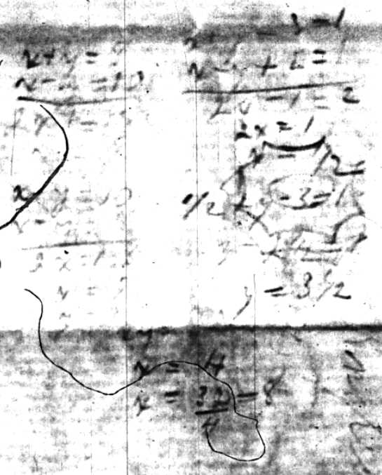
Algebra equations on the backside of a sheet from this letter.
“Dexter Ward was born in Chittenden VT and came to Grant County on February 8, 1843. He settled in Lancaster where he was a carpenter and builder. He was elected Counstable in 1857 (? Possibly 1847) and held that job for 5 years. He was a deputy sheriff under Matthew Woods and George Stuntz.”
~ GrantCountySheriffWisconsin.com
Take good care of your life & health and do as well as you can for yourself. I will write you again before leaving for VT. You may be [apsment?] that it looks rather better about here where there are [lesasy?] crops all about me than about the Lake where there is nothing. I called at the Sherriffs & left William’s letter, found all well.
In haste your affectionate father
G. A. Barber
Interior Field Notes
Odanah Townsite aka “The Gardens”
La Pointe Indian Reservation
Township 48 North, Range 3 West
November, 1856
Notebook ID: [N/a?]
!["For Plat of Townsite Odanah LaPointe Indian Reservation [...] See Large Plat Book [s]Next to last page[/s] Middle of Book" ~ Board of Commissioners of Public Lands](https://chequamegonhistory.com/wp-content/uploads/2015/12/1856-odanah-town-plat.jpg)
“For Plat of Townsite Odanah
LaPointe Indian Reservation
and Resurvey of Sec 23, 24, 25, 26, 35, & 36
See Large Plat BookNext to last page
Middle of Book”
~ Board of Commissioners of Public Lands

“*Note Sections 23, 24, 25, 26, 35 & 36 having been previous surveyed by Mr George R Stuntz have been omitted by J. Allen Barber Dept. Surveyor, under Henry C. Gilbert, Indian Agent, so says Mr Barber but no evidence can be found to support his declaration either in the Gen’l L. Office or Indian Bureau. Secs 23, 24, 25, 26, 35 & 36 were recently surveyed by A.C. Stuntz so says the Comm’r Indian Affairs in his letter of Feb’y 6, 1865, inclosing a diagram thereof.”
~ General Land Office Records
LaPoint Nov. 22nd 1856
Dear Mother

Detail of the “Chippewa Gardens” at Odanah from Summary narrative of an exploratory expedition to the sources of the Mississippi River, in 1820, by Henry Rowe Schoolcraft, page 105.
—
The steamer Superior was lost near Grand Island, Lake Superior, October 29, 1856, during a violent storm. Her rudder was carried away and the boat fell into the trough of the sea. She commenced making, the fires were put out and she struck the rocks, soon after going to pieces. Thirty-five lives, including 11 passengers, were lost, and 16, including five passengers, were saved. Capt. Hiram J. Jones was among the lost. The Superior was considered one of the best sea boats in the trade, and had lived through many a storm. She left Chicago October 25, loaded principally with supplies for miners.”
~ History of the Great Lakes, Chapter 37.
Yesterday I arrived here from Bad River in a Macinaw boat with two fair men, we have been surveying nearly two weeks although we have scarcely made a beginning. Thus far we have been at work at “the Gardens” as the settlement at Bad River is called to layout out an Indian Village. I was over to Bay City [???] Wednesday to see about getting provisions for the winter but got [clism?] appointed and found others in the same fix. Mr. Stuntz had promised to furnish us with provisions but all his supplies were last on the Superior. You have probably seen an account of that said disaster. The boat was last on the pictured rocks in the night, 45 or 50 lives were lost, only 16 saved. As for us I have heard no one was lost that I know personally. No one may prove Superior with [3 Sisters?] were lost. [This?] father lived in Superior – his name is [Mentar?]. I have not much news to make. I think my prospects [to get?] surveying are pretty fair. I have been successful in getting a fair supply of provisions and if anything happened I believe we will do a pretty fair lot of work within the next month or two. My provisions are not thought to be scarce but so navigation is closed prices will be high.
Pork is 30 dollars per Barrel, Sugar 15 or 15 cents per pound.
I have not yet decided when to go below but I should probably see Lancaster before many months.
Last night I attended a half breed ball – not as a participant but as a spectator. The balls are rather an important affair as they generally last three days.
Last night was the third night and was necessarily the last as the ball was very suddenly “broken” by the Catholic priest about 8 o’clock. The priest and Bishop came to the door and demanded admittance and the priest went in and after asking a few questions commanded them to disperse and you may depend on it there was a scattering.
Ironton is prospering finally. Today I sold 6 shares at $60 per share. They were sold to two men who are at work for me and are good men. I am writing this in Squire Bell’s office and the others present are getting [warm?] and it is getting dark so I will fold this up.
Your affectionate Son
Allen
Interior Field Notes
La Pointe Indian Reservation
Township 47 North, Range 3 West
December, 1856
Notebook ID: [N/a]
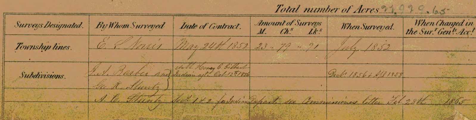
Contract awarded by La Pointe Indian Agency to Joel Allen Barber and George R Stuntz on October 12th, 1856. Survey partially completed by Barber and Stuntz during December, 1856. These survey notes are not available from the General Land Office or the Wisconsin Board of Commissioners of Public Lands.

Detail of Sturgeon Falls on the Bad River omitted from Barber’s resurvey during 1858.

Detail of the White River omitted from Barber’s resurvey during 1858.
Lancaster, Sunday Dec 7th 1856
Dear Son Allen
Here I am yet, amid my friends in this beautiful country. It was far from my intention to have spent so long a time here, but one hindrance after another has prevented my getting away. It is my design to leave the present week & stop at Sandusky probably over next Sunday. I have now passed by my friends three times, and feel as though to do so any more would look like studied neglect of them.
My disappointment at not getting any thing from you up to this time is great, & I now begin to hope you have sent a letter or two to Vermont instead of here, & that I shall find them all right when I get there. Though to tell the truth I am in some concern for your safety, fearing that you have been wrecked on your journey from La Pointe to Ironton or Bad River. I am still in hopes to get a letter from you tomorrow or before I leave the place. Your friends are all well hereabouts, and everything carry on swimmingly.
Thode Burr was dismissed from Ryland & Swab’s employment last Monday, not for any fault but because Ryland has got well enough to work in the Store “[the St Louis?]” are able to do all their business. He is doing nothing at present though he could have $30.00 per Month to go into a school at [Baserbol?]. I mistake perhaps in saying that he is doing nothing, for he is attending [any/my?] [earnestly?] to his [hymn?] & nothing else.
George Parker & Lincoln of [Midden?] (you know him) are in DTP [stom?]. Lincoln was in College 2 years & had to quit on account of sore eyes after trying to resume study twice. He gave me the following items concerning some of the Johnson Boys.
[Thuler?] was expelled last June for participating in the annual mock training contrary to the command of the College Officers. He talked of going to [knive Coll. Schunistudy?], but has not yet. Hotchkiss had to quit College & has gone to work on the farm. [Spurr?] is Married to a Miss [Denny?] of [Largage?] a real visage and was teaching in Mass. receiving $1000. for his & his wife’s services for [canninor?].
This is all that he told me of them. Had there been any thing else worthy of note, he would have told of it.
I wrote you about the Small pox being in the town & that there had been some deaths. Whether there have been any since my last I cannot say. Only 3 in all. There are no new cases for some 10 days or more & it is hoped that it will spread no further. Mr. James Mc[Gonigal?] brother to William from Tennessee was was buried last Sunday. He was taken sick of fever the Sunday previous, & went to bed saying, that was the last time, & was expecting to die untill he breathed his last on Friday night at 10’o’clock. He was a very fine young man, had lost a wife & only child, before he came here, & has been clerk for D.T.P. for some time.
Wm Carter & Miss [Rawdon?] were married last Thursday.
I should feel much better if you were living in this country than I do now, when my mind is constantly worried by thoughts of you suffering from cold, fatigue, hunger & all sorts of privations, to say nothing of being deprived of all society congenial to your natural taste.
I cannot sit down to a good meal or get into one of the warm soft comfortable beds, without thinking of my poor son who is where all such things are unknown, and may be suffering for want of the comforts that here so much abound and especially did I think of you last Sunday when there was the worst storm of snow from the N.E. ever known in the Western part of Wisconsin, so said by all the badgers. Snow fell 18 in deep in the timber, but it piled up in the roads & streets like it does in Vermont. The snow was drifted into one place East of Galena 40 feet on the track with a freight train beneath. They got the [cars?] through yesterday. The weather has been very cold here for this time of the year. Thursday Morning 4th Therm 11* below 0, Friday 14* below 0, & Saturday 6th at 14* below 0. I do not believe Vermont ever beat that in the 1st week of December, & in all that time I have been thinking how you & your company must suffer if out in the woods surveying.
I hope you keep warm nights, if so, you can do enough in the day to keep from suffering. My greatest fears at present for your [sloping?].
Allen Hyde has been very swift to purchase the little farm and has offered $35.00 per acre by my taking $415.00 of it in two lots of land. One of five acres South of the burying grounds at $315, & directly opposite the new schoolhouse. The other is a meadow of 8 acres out towards where [Sprader?] used to live at $[6.00/600?] which is cheap for either place. But I shall not be in great haste about selling for I should prefer that that little piece of land should remain in the family even if I do not live to come on it myself. There is quite a stir about farms at present. There was a Mr. Hayward from N.Y. State wishing to purchase & bartered for Jay’s farm & I think would have paid $50.00 per acre for it but Jay would not sale without he could put in his 2 ½ acres of an out lot with it. Mr. H. offered Frank Hyde $36.40 per acre for his land, East of Hollaway’s & did buy Hyde’s new brick house built the summer past near Esq. Philp’s new house, at $1,000.
Tell Jo that I think I shall want to buy his land when I can see him. I went to it soon after I got here, but I was sick all the time so I could scarcely move, consequently did not see much of it & cared very little for what I did see. Tell Wm. W. Ward that I did as I promised to do, & went to his Father’s and had a good meal that would astonish any body from Lake Superior. I have been there three times since I came, I wish you boys could have had some of the chicken din & other fixings… Wm’s eldest sister played on the [a Melodron?] & sang a number of [piren?]… Mr. Richard [Myers?], an old country Dutchman who married Martha Phelps’ sister to your Aunt [Lucy?], is erecting a steam Sawmill just across the brook due East from your Uncle Allen’s & intends to have it ready for business in the spring & Mr. [Kirke?] of Philadelphia talks of coming here to erect a Steam Gristmill in the springs.
Some things are as dear here as in the country around you. Coffe 6 lbs per $1.00. Sugar 7 lbs per 1 doll. Butter 25¢ for [good/gevd?] but Pork sells for 5. to 5.50 [gevd?] fat beef rather better than [Cousin?] Ox for [?] for [foze grs?] & 5. for Hind do. Flour $2.50 per 100 lbs, &c. Venison is brought in and sold frequently & on the whole I think there is more comfort in living here than there you can be on the Lake.
I find considerable difficulty in settling off with Old Black for the proceeds of the little farm but shall get through with him tomorrow I now hope he has drawn some [manners?] on the orchard & and done some [plervisy?] for [Sish?] he charges exorbitantly, all done before I came & he had harvested most of the corn, but I am confident the dishonest whelp will cheat me out of a good deal any way I can fix it, but I will get shut of him some way and remain so ever afterward. He has sold his tavern stand today & taken a farm 4 miles north of the Village in payment of a Mr. Wilhinson. There is a new store opened in the [forver?] East of the Burnett House where J. M. Otis over traded by two men under the firm of Baily & Carroll who are giving the build a new Gristmill below Handall’s Sawmill.

Portrait of Uncle Joel Allen Barber from page 199 of the Proceedings of the State Bar Association of Wisconsin, Volume 1900.
The prospect now is that your Uncle Allen will be elected U.S. Senator for the next 6 years after the 4th March next. I would not write this had I not good reasons for believing that it will be so. And now in regard to yourself, I do hope you will be careful of your life and health, that you will avoid exposure to the dangers of the cold & the treacherous ice as much as possible. That you will not trust yourself on the ice, long distances in the cold or storms, or alone. Finally I beseech you to take all possible care of yourself. If you have not got blankets enough to keep you sufficiently warm nights do so & get more & not suffer or be uncomfortable without or for want of them. I do not feel reconciled to the thought of going home without hearing from you, & knowing that you are alive & well. I overhauled the trunk of our dear lamented Augustus yesterday and [leave?] nearly every thing as I found it. There are some good clothes, that may be of service to you, should God spare you to ever come down here. I have rec’d a number of letters from home since I got here, but none lately, as they are probably expecting me home about this time, all were well. I do not know whether I mentioned in my letter to you that your mother had drawn $209. from Government additional pension money.
Adieu my dear son.
That our Heavenly father will bless and preserve you is the daily prayer of your affectionate as well as afflicted father.
Giles A. Barber
To be continued in the Winter of 1857…
Barber Papers: “Ironton” Summer of 1856
December 16, 2015
By Amorin Mello
This summer was a time of trauma for the Barber family immediately following the death of Augustus Hamilton Barber at the mouth of the Montreal River near his town-site claim of Ironton during the Spring of 1856. Augustus had unfinished business on Lake Superior, which was being attended to by his brother Allen and father Giles in mourning.

Item from the Superior Chronicle, August 19th, 1856. Ironton was platted during February of 1856 according to the Bayfield Mercury, August 15th, 1857.
The Summer of 1857 was also a when the town-site claims of Ashland and Ironton were being established and platted by merchants near the east and west borders of the Bad River Indian Reservation. Several memoirs about the early days of Ashland and Ironton will be featured in this post to provide context due to copies of certain letters being missing from the Barber Papers. Only one letter was archived from the Summer of 1856 in the Joel Allen Barber Papers, located at the end of this post.
Oral history traditions from the Lake Superior Chippewa tell about how the language describing the exterior boundaries of the LaPointe Indian Reservation were changed sometime between the 1854 Treaty of LaPointe negotiations and when it was ratified by Congress in 1855. According to at least one oral history, both Ashland and Ironton were located within the boundaries negotiated at the treaty.
The Ashland Press
January 4, 1873
—
Ashland! It’s Growth During the Year 1872
A Quarter of a Million Dollars Expended in Improvements.
A Full List Of Buildings—Docks—And Railroad Work
ALL HAIL TO THE IRON CITY
The history of Ashland, full and complete, would require more space, and more labor in its preparation, than we can possibly give it at this time. Nor is it necessary in connection with this summary of its growth during the first year of its regenerated existence, to enter into an elaborate or extended article upon its past fortunes, but merely to give an outline showing its first organization, and a few of the most important items incident to its early settlement. This much we shall endeavor to do in this article, and no more, leaving other and better informed persons to give a full and accurate historical record, hereafter.
July 6, 1933
by Guy M. Burnham
“During the month of February 1854, Leonard Wheeler, the missionary and an Odanah Indian met at Odanah, where Mr. Wheeler then lived, and drove on the ice along the south shore of the Chequamegon Bay, from Kakagon to Fish Creek. It was the year of the great treaty, in which the Indians agreed to cede most of their lands to the United States and to reserve tracts for their permanent homes. The Indians were glad to do this, for only four years before; the government had decided to move the Chippewa to the Minnesota country. William Whipple Warren led a large delegation to Minnesota but like all others who were interested, they much preferred Wisconsin. Leonard Wheeler himself, took up the cudgel of his wards, and practically led the fight to prevent the removal of the Chippewas from Wisconsin, but in 1854, it was understood that some sort of agreement was going to have to be reached, for white settlers were looking to the north, and they need an outlet to Lake Superior. The Indians realized that they would have to do something so Wheeler, the missionary and Little Current [aka Naawajiwanose], the Chippewa, were delegated to look over the south shore of Chequamegon Bay. William Wheeler who was a small boy accompanied his father and the Indian on the trip, says that the Indians furnished the pony and the missionary the cutter, and they drove down past where Ashland now stands, to the extreme head of the bay. From the head of the bay region, at Fish Creek to nearly where Whittlesey afterwards built his first house, there was a straggling Indian settlement, which the Indians called Equadon.
Every foot of land from Fish Creek to Odanah was Indian Land. It was in this settlement or village, which the wife of Robert Boyd, Jr., told me her father, lived in Equadon, near the many flowing springs, which we now call Prentice Park. The Indians thought the western limits of the proposed reservation of Bad River, should be the west end of the bay, but the missionary pointed out that that would keep the white men from building a city on the south shore of the bay, and that it would be advantageous to the Indians to have such a city built, as it would furnish a market for their furs and other products they might have for sale. Little Current agreed to this, and then and there, the agreed on the western limits of the Bad River Reservation should begin at the Kakagon just as it is now, extending the reservation far enough south to make up for the loss of the frontage from Kakagon to Fish Creek. Asaph Whittlesey frequently talked with Leonard Wheeler about good sites along the south shore and so about four months after the momentous trip of Leonard Wheeler and Little Current, near the end of February. Asaph Whittlesey and George Kilbourne rowed a boat over from Bayfield and felled the first tree, built the first house, establishing the settlement, which was to be known for about six years as Whittlesey. When Whittlesey felled the first tree on July 5, 1854, the land still belonged to the Indians. Three months later, on September 30, 1854, the Treaty of La Pointe was signed, under which Bad River, Lac Courte Oreilles, Red Cliff, the tip of Madeline Island, and Lac du Flambeau were reserved, but it was not until January 10, 1855, that the Senate ratified the treaty, which became a law by proclamation of President Franklin Pierce, on January 29, 1855.
Although Whittlesey built his first house on land, which still belonged to the Indians, there was little danger of the Wheeler-Little Current agreement being disturbed, and Whittlesey became Ashland in 1860. The head of the bay, which then, as well as now, swarmed with fish and game, became a part of the white man’s domain, and this included the Place of Many Springs, Prentice Park.”
~ TurtleTrack.org
Old Ashland, to be properly written up, should be woven into the history of all the country extending from the head of Lake Superior to Ontonagon. This section from the beginning of the first settlements has been intimately connected in all its various fortunes, and its people of that date should be considered as one, and spoken of as the early day pioneers on the Lake. Scarcely an enterprise was attempted that a majority were not more or less interested in, and the early Ashlander was not satisfied with being limited to one small portion as the place of his adoption, but generally considered himself honored only when credited with being a citizen of the “Superior Country,” or as many term it, “of Lake Superior.” Like the old fashioned “Queen’s arm” the early settlers “scattered” terribly, and hence we find them at the present day, posessors of corner lots in exploded townsites, parchment mining stocks, iron lands, copper mines, mineral claims and silver veins, in almost every section of the south shore that has been explored. To enumerate all the enterprises attempted by these enterprising, pushing-ahead, speculating men, would be too great an undertaking for us, but a book, well written, giving a thorough history of their operations, would not only be intensely interesting, but posess a value scarcely to be enumerated. But it is not our purpose to digress. We have to do with Ashland only, and chiefly with its present growth and future prospects.
The Ashland of to-day was formerly Bay City, St. Mark and Ashland, two distinct townsites, located but half a mile apart, the intervening territory being that platted as St. Mark, best known as Vaughn’s Division. Each of these divisions has a history of its own, though of course more or less connected with each other in common interests. These three divisions have, since the new enterprise sprang into existence, been joined together and now constitutes the city of Ashland, all parties interested working harmoniously for the common interest and a general prosperity.
August 28, 1920
“Mr. [William] Wheeler was born at the mission at Odanah and remembers distinctly of a trip he made with his father [Leonard Wheeler] and one of the Indian Chiefs [Little Current aka Naawajiwanose], into the country to establish the boundary limes of the Bad River reservation. The Indians wanted the boundary line at Fish Creek but Rev. Wheeler told them to leave a site where the present city not stands, for he was certain that a big city would grow up and big boats from the outer world would sail into the harbor and that the people would furnish a market for the Indian’s products.”
~ Wisconsin Historical Society
On the 5th day of July, 1854, Asaph Whittlesey and George Kilbourn landed on the bank of Ashland bay, and immediately commenced the erection of a claim shanty, within fifty feet of the west line of Section 5, Town 47 north, Range 4 west, in Ashland proper. The first tree was felled by Mr. Whittlesey, on that day, and by night the first log house, 14×16, was commenced. On the 27th day of August this building was occupied by Mr. Whittlesey’s family. It was used many years after for various purposes, and its ruins can still be found on the bank of the bay. During the same season the small log house near the present residence of James A. Wilson, Esq., on lot 6, block 6 was built, and in November of the same year the largest of the three log houses now standing on the same lot was completed and became the residence of Mr. Whittlesey, which he occupied until the fall of 1857. This house has quite a history. It has witnessed many an exciting and tragic scene, as well as many a pleasant and happy gathering. If its walls could speak, and possessed the genius of a Shakspeare, they would tell a story that would out rival in magic fascination any work of fiction. It was within its walls that the first permanent white settlers in Ashland dwelt. In its spacious room in the winter of 1854, the man of God, the missionary in the cause of Christ, preached the first sermon ever preached on the town-site. The minister was the late Rev. L.H. Wheeler, founder of the Odanah Mission, and a man known as a good and earnest Christian missionary, loved and respected by all the border settlement. It was here that the first ball was given in 1854; the first Fourth of July celebrated, in 1855, some thirty persons participating. It was the first post office, established in March, 1855, with Mr. Whittlesey as P.M. It was here too, that the first election was held, in the spring of 1856, at which time the town of Bayport, (which included Ashland and Bay City and all the surrounding county,) was organized. It was also the scene of a sad tragedy, when Henry Cross, in self defense, shot and killed Robert D. Boyd in 1858. The first Sabbath School was organized in this house in 1858, by Ingraham Fletcher, Esq. It was also, May 31st, 1856, the birth place of Miss Delia E. Whittlesey, the second white child born in the town, the first birth being that of Katherine Goeltz, early in the same month. Many other interesting events might be enumerated as belonging to its history, but space forbids. The old house still remains a monument of Ashland’s former glory.
The first freight ever landed from a steamer in our harbor, was in September, 1854. The steamer “Sam Ward,” Capt. Exsterbrook, brought the household goods of Mr. Whittlesey to Ashland at that time, and they were landed in small boats in the ravine near the foot of Main street.
“The first marriage in the town was that of Martin Roehm to Mrs. Modska, in the fall of 1859, John W. Bell officiating, (music furnished by Conrad Goeltz,)” and a good time generally indulged in by all who participated in the festivities. And here let us state that Ashland was never forsaken by this sturdy veteran pioneer couple. They stood by the place with characteristic German fidelity, king and queen of the deserted village, corner lots and all until the dawn of the new era commenced.
The Indian in his might
Roamed monarch of this wild domain,
With none to bar his right.
Excepting fearless Martin Rhoem.
The first government survey of the territory around the head of the bay was made in 1848, when the township lines were run by S.C. Norris, deputy U.S. Surveyor. It was not subdivided, however, until 1856. The town-site of Ashland, embracing lots 1, 2 and 3, and the N. half of the S.W. quarter, N.W. quarter of S.E. quarter and N.E. quarter Section 5, Town 47, Range 4, was surveyed and platted by G.L. Brunschweiler in 1854, and entered at the United Stated Land Office, at Superior, by Schuyler Goff, County Judge, under the laws then governing the location of town-sites on Lake Superior, December 11th, 1856, for the use and benefit of the owners and occupants thereof, viz: “Asaph Whittlesey, George Kilbourne and Martin Beaser.”
Succeeding the first settlement above mentioned, the population of Ashland increased quite rapidly. During the year 1854 several families moved in. Among the new corners were Martin Beaser, J. P. S. Haskell, Austin Cousen, John Cousen, Conrad Goeltz, A. J. Barclay, Capt. J. D. Angus, G. L. Brunschweiler, Frederic Prentice, Adam Goeltz, John Donaldson, David Lusk and Albert Little. Of these a few remained only a short time, coming merely for temporary purposes. 1855 brought a still larger increase of inhabitants, among them M. H. Mandlebaum (now a resident of Hancocck, Mich.), Augustus Barber (who was drowned at Montreal River in 1856), Benj. Hoppenyan, Chas. Day, Geo R. Stuntz, George E. Stuntz, Dr. Edwin Ellis, Martin Roehm, Col. Lysander Cutler, J. S. Buck, Ingraham Fletcher, Hon. J. R. Nelson, Hon. D. A. J. Baker, Mrs. Conrad Goeltz, Henry Drixler (father of Mrs. Conrad Goeltz, who died in 1857, his being the first death in town), and Henry Palmer. In 1856, Mrs. Beaser (now Mrs. James A. Wilson) arrived, also Oliver St. Germain and family, still here; Mrs. J.D. Angus and family, John Beck and family, Schuyler Goff (afterwards County Judge) and Chas. E. Tucker. In 1857, Mr. Eugene F. Prince and family, A. C. Stuntz and family, Wm. Goetzenberger, Geo. Tucker and others arrived.
On the 25th of October, 1856, Hon. S.S. Vaughn pre-empted Lot 1, Section 32, Town 48, Range 4, and the East half of the N.E. quarter and the N.E. quarter of the S.E. quarter Section 5, Town 47, Range 4, the same being now Vaughn’s Division of Ashland. In 1856 Bay City was surveyed and platted, the town-site being owned by a stock company, of which Dr. Edwin Ellis was the agent. Under his direction a large clearing was made, a store, hotel and several substantial buildings created. A saw mill was also commenced, the frame of which is now standing near the east end of the new bridge across Bay Creek creek. During the same year and the next following improvements were being rapidly made in old Ashland. Martin Beaser, Esq., who was the leading business man and property holder of the place, gave it its name, (after the homestead of Henry Clay, he being an ardent admirer of that eminent statesman,) and erected the store and residence now occupied by James A. Wilson, Esq. Eugene F. Prince built his present residence, and quite a number of dwellings were put up, several of which are still standing and have been fitted up and occupied, while others have been destroyed or fallen into decay. Temporary docks were built both at Bay City and Ashland.
The Ashland dock was built by Martin Beaser and cost about $4,000. Both however were allowed to rot down and wash away. Main street and a portion of what is now Second street, as well as a number of avenues were opened and improved. Additions were also platted, and most prominent being ”Prentice’s Addition,” in 1856, and the Ashland of that day presented a live and vigorous aspect, containing as it did a thrifty and energetic class of citizens.
“With the continuing reports of minerals in the area and some mining being done, another group of hopefuls sought recognition as a corporation and received charter to begin mining. This corporation was formed in Milwaukee and was known as the Wisconsin & Lake Superior Mining & Smelting Co. Its charter was granted in 1856 by the State of Wisconsin, and with the charter the company was granted about 1,900 acres of land in the Penokee Range, some of which is now in Iron County and some in Ashland County.”
[…]
“The other two villages planned for their mining venture were Springdale and Lockwood.”
[…]
“Ironton was the headquarters for the officers for only a short time. They moved their office duties to Ashland shortly after getting established.
The names of some of the merchants from Ashland who planned to be the suppliers for these villages included McElwin [McEwen], Herbert and Mandelbaum. Herbert’s name is mentioned in other areas as well as the name of Mandelbaum, who is mentioned in the history of Ontonagon also.”
~ A Historical and Archaeological Reconnaissance of the Saxon Harbor area, Iron County, Wisconsin by John F Wackman et al, pages 57-58.
This was in an era of speculation and Lake Superior the theatre of many a town-site and mining operation, The Penoka Iron Range had begun to attract the attention of eastern capitalists, while the Copper Range and the mineral regions of the Porcupine Mountains had drawn thither a number of daring adventurers, who sought their fortunes in the discovery of valuable metals. Railroads too were projected then, and the brave surveyors with their compass and chains were penetrating the forest and engineering a path through a trackless wilderness to the land of civilization that lay far away to the south. Ashland then, as now, was the center of attraction, and to possess corner lots and broad acres was to realize one’s fortune.
But Ashland was not alone in its glory. Superior City, at the head of the Lake; Red Cliff, Bayfield, Houghton and La Pointe, among the Apostle harbors; Ironton, near the mouth of Montreal river on Raymond Bay; and Ontonagon, Copper Harbor, Eagle River, Hancock, Houghton and Marquette, on the peninsula of Michigan, were each points of interest and struggling for an existence, their claims being urged by their proprietors with characteristic energy. Money was lavishly expended; mining both of copper and iron largely engaged in and the whole country was apparently undergoing that rapid development that leads to general prosperity and thrift.
[…]
The Ashland Press
February 26, 1926
—
CITY OF ASHLAND IS 72 YEARS OLD TODAY
May 3, 1910
“In the year 1855, Dr. Edwin Ellis located upon land to the eastward of Whittleseys. Instead of locating under the town site laws, Mr. Ellis entered a homestead and began to literally hue out his path to civilization. Several of the doctor’s friends joined him and located on adjacent land and soon there was a plat filed of the town of ‘Bayport.’ After a few years of continuous hardships and disappointments, the hardy pioneers became disheartened and some even moved away. The plat of ‘Bayport’ was declared vacated, but when business began to revive and new settlers came in 1872, the old town plat was revived and reinstated by Dr. Ellis as Ellis Division of the city of Ashland.”
~ Wisconsin Historical Society
The city of Ashland is seventy-two years old today, for on Feb. 24, 1854, Dr. Edwin Ellis landed in Ashland, at a spot where Whittesey Avenue now is located. Dr. and Mrs. Ellis had come from Maine and stopped at St. Paul, with Mrs. Ellis’ brother. From St. Paul, Dr. Ellis walked all the way to Superior. Then to Bayfield, then to La Pointe, in the ice, and then on to Ashland. He constructed the first log cabin at what is now Whittlesey Avenue. Asaph Whittlesey and Kilbourn, the next white men to come to this part of the country, arrived in June or July of the same year.
In 1855, Dr. Ellis walked to Dubuque, Iowa to file a petition to have this country surveyed. The trail which he took was know as the St. Croix Falls and from there Dr. Ellis took a steamer down the river to Dubuque. In 1856 he went to St. Paul and brought Mrs. Ellis and the two girls back with him.
The American Fur Company was situated at La Pointe, at this time but had very little to do with the mainland. The people in the early days sent to Chicago for their supplies. As there was always somebody walking to St. Paul they would send their orders by one of these men and from there the mail was taken to Chicago. The suppliers would come up on the last boat which came up Lake Michigan to what is now the Soo Canal.
Twice the boats on their last trip were wrecked and the early settlers would be without supplies for the winter.
The principal food was fish. Deer at that time always left the country during the winter.
Martin Beaser and party arrived here a short time after the Ellis’ but the Beasers settled on the shore where Beaser Avenue is now situated. This whole country was a mass of woods and the Beaser home. which is now the Jack Harris home, was practically the only house at what is called Old Ashland. When the Ellis Family visited the Beasers they had to hitch up the oxen and go through the dense woods.
Scott Ellis was born August 24, 1824, which is also the birthday of Queen Victoria. He died May 3, 1903, at Ashland, after watching the city grow from a dense forest to the present city.

July 28, 1877
Recollections of Ashland
“OF WHICH I WAS A PART”
Number V
This memoir was ghostwritten for The Ashland Press by Doctor Edwin Ellis.
Mr. Dear Press: – As has been already stated, the land on which Ashland now stands, had not, at the time of its first settlement, in 1854, been surveyed. The town lines had only been laying off the country into blocks six miles square.
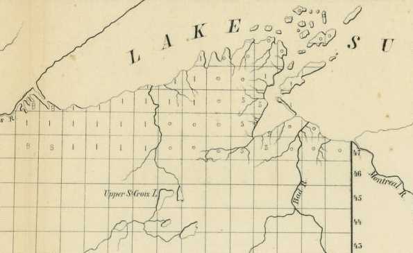
Detail from Sketch of the Public Surveys in Wisconsin and Territory of Minnesota by the Surveyor General’s Office (Warner Lewis), Dubuque, Oct. 21, 1854.

“In 1845 [Warnen Lewis] was appointed Register of the United States Land Office at Dubuque. In 1853 he was appointed by President Pierce Surveyor-General for Iowa, Wisconsin and Minnesota and at the expiration of his term was reappointed by President Buchanan.”
~ The Iowa Legislature
Wisconsin, Iowa, and Minnesota, then were embraced in one Surveyor’s District, with the office at Dubuque, Iowa. It was the duty of the Surveyor General to provide for the details of the Government Surveys in his district, as fast as the settlement of the country might require. Gen’l. Warner Lewis was then Surveyor General of this District.
~ The National Magazine; A Monthly Journal of American History, Volume 9, page 23.
No steps having been taken or any order given for the survey of the shore of Chequamegon Bay, in June 1855, Dr. Ellis left in an open boat for Superior, then on foot through the wilderness to St. Paul, following not far from the route over which many years later was constructed the Lake Superior & Mississippi R.R., – then an early settlement here induced Gen. Lewis to order an immediate subdivision of Towns 47 and 48, North of Range 4 and 5 West, both sides of our bay, and all the lands on which squatters had settled.
Early in September of that year, (1855), Augustus H. Barber began the survey and pushed the work rapidly, so that he had completed 47 and 48 of Range 4 in October, and the returns had been made and plats prepared and forwarded to the local land office by the first of December.
The Pre-emptors now, for the first time, could file claims to their lands and receive assurance that they were likely to be the owners of their homes.
During December many pre-emption claims were filed, and during the closing days of the year and in the first days of 1856, quite a number proved up those claims and received duplicates, upon which patents were afterwards issued. These were the earliest titles to the present site of Ashland. Unlike many towns in the West at that period our site was not cursed with complicating claims, and it is cause for congratulation that Ashland property has no cloud upon its title and that every buyer may, with little trouble, assure himself o this fact. The title to a portion of the site of Superior was bitterly contested involving years of delay and thousands of dollars of cost and much acrimony of feeling; and it is possible that this may have had its influence in carrying the railroad to Duluth rather than to Superior. Quarrels over title are a curse to any town, especially a new one.

“IN MEMORY OF
AUGUSTUS H. BARBER
of Cambridge, Vt.
U.S. Deputy Surveyor
who was drowned in Montreal River.
Apr. 22. A.D. 1856
Aged 24 yrs. & 8 ms.”
~ FindAGrave.com
Of Augustus Barber the early Surveyor of this vicinity, who is unknown to a larger part of this generation, a few words ought to be said:
He was a native of Vermont of an excellent family. At this time he was 22 years of age, well educated, gentle as a lady, refined and easy in his manners and very amiable in his temper. Like many other young men from the east, of active enterprising habits, he had come into this outer verge of civilization to make this his home and to grow up with its institutions. He was the nephew of Hon. J. Allen Barber, of Lancaster, in this State, who once represented his District in Congress. He continued in the surveys of this part of the Lake until in the summer or fall of 1856, when he, with others, conceived of the idea of founding a city at the mouth of the Montreal River – the dividing line between Wisconsin and Michigan about thirty miles east of Ashland.
“According to the Bureau of Public Lands, Department of the Interior, the land surveys were not completed in that area [Ironton] of Wisconsin nor offered for sale to the public until November 18, 1866.
[…]
“A practical location for an operating headquarters was chosen at the site of the Indian settlement on the shore of Lake Superior on that piece of level ground where there were mountains on three sides and through which a creek ran. The village at this location was named Ironton, and because of the activities planned for it and two other mining locations farther inland a group of merchants from Ashland assisted in building up this boat landing and supply headquarters. A dock was built and several buildings for warehouses and some living quarters.”
~ A Historical and Archaeological Reconnaissance of the Saxon Harbor area, Iron County, Wisconsin by John F Wackman et al, pages 57-58.
The iron range approaches nearer the Lake at that point than it does at Ashland. And though the country is much rougher and more difficult for construction of roads than between Ashland and the Range, yet the shorter route, it was argued, would more than compensate for the heavier grades. –The town was laid out and platted by Mr. Barber.
As indication of its future chief industry, as the entry point of the iron range – it was called “Ironton,” with the accent on the second syllable. Great expectations were entertained of the future importance of the place, and much land was entered in the vicinity.
The Montreal, not far from its mouth, leaps down a perpendicular descent of nearly a hundred feet presenting a wild and picturesque view. Being an enthusiastic lover of the beautiful of nature and desiring to reach a position underneath the falls, Mr. Barber in a canoe with two companions, approaching too close, were drawn in by the eddying whirlpool, the canoe was capsized, and before help could reach him he and one of his boatmen were drowned. his body was recovered and was buried on a sand hillock near the mouth of the same river in whose waters he met his death. Ironton has long been deserted, and Barber’s grave with its marble headstone, is the sole mark of that civilization, which twenty years ago there essayed to lay the foundation of a mart of commerce.
The surf of the waves of the lake in summer and fierce driving snow storms in winter, with solitude presiding over the grand orchestra, are perpetually chanting his mournful requiem, while a fond father and mother on the slopes of the distant Green Mountains are mourning bitterly the early death of their first born son.
Interior Field Notes
Ironton Townsite
La Pointe Indian Reservation
Township 47 North, Range 1 West
November, 1856
Notebook ID: [N/a]
This survey is mentioned by multiple sources, however, the Barber Brothers’ field notes and plat map for Ironton from 1856 are not available from the General Land Office Records or from theWisconsin Public Lands Survey Records. Did Warner Lewis receive them at the General Land Office in Dubuque, Iowa? The search for these survey notes continues.
Selected letters of the Joel Allen Barber Papers
… continued from Spring of 1856.
Superior City Sept 15th 1856
Dear Mother
“Ironton’s potential was very promising. While all the activity was taking place for a mining center, plans were being made by the Milwaukee & Superior Railroad to extend its line northward from Stevens Point to a terminus at Ironton at the shore of Lake Superior, then to continue west to Bay City (now Ashland).”[…]
“Besides the officers of the mining company, several businessmen of Ashland became interested in a railroad between Ashland Penokee Gap.
Some of these men were J.S. Beisch, Martin Beaser, John S. Harriss, I.A. Lapham, J.C. Cutler, Edwin Ellis and T.C. Dousman. This railroad was to be the Ashland & Iron Mountain Railroad. A lot of planning and some work was being done when quite suddenly the Panic of 1857 came on bursting many bubbles and bringing to a halt all of the mining activities, causing an exodus of many workers and a large number of potential settlers.”
~ A Historical and Archaeological Reconnaissance of the Saxon Harbor area, Iron County, Wisconsin by John F Wackman et al, page 60.
I wrote a few words to you a few days ago when I was unwell and had to be rather short. I have since recovered my usual health and will try to write a longer letter, but I am afraid it will be of little interest. I see you are anxious that I should quit the lake. It is not strange that you should wish dread to have me remain here. You wish me to come to [?] to Lancaster or any where but here.
Now to tell the truth I am as much attached to this lake as to any other place and I don’t know how to leave it. I know its disadvantages and privations as well as any one. I know the sweets of a more social life and much do I long for them. I know the luxury of living on a fertile soil in a genial climate and hope some day to enjoy it, but still if my life is spared Lake Superior will probably see me occasionally for a number of years.
You ask me my opinion in preference between a good farm in Grant County and ten miles of forest in this country and be bound to it. But I should not be bound to it if I owned [40/41?] miles and there are many farms about here worth more money than any farm on Lamoille river of twice the size.

Detail of Ironton property with trails to Odanah and the Penokee Mountains from T47N-R1W. This survey map was from Elisha S Norris during 1861.
I hope to visit Lancaster this fall but the middle of winter will see me threading my way back to this wild country. I would like extremely to visit Vermont next winter if possible but I expect my engagements will render it impossible.
I hope you will not dwell too much on the terrors of his country and fancy I am suffering all imaginable hardships. I am never hungry and seldom cold or over fatigued. I like the climate about as well any south of here and would sooner emigrate North west than South East, were I not bound by social ties. Were I to follow agriculture as a source of profit I would not go to Vermont or Grant County.
In regard to my Ironton property I have no hopes of getting you to think as you do.
Hon. D. A. J. Baker was introduced as an early resident of Ashland in our Penokee Survey Incidents series. Baker appears to be in business with the Barbers at Ironton.
“A trail between “Penokee” and Ashland is shown on Stuntz’s map of 1858. An Indian trail between Ironton and Odanah was improved for transportation and communication when land travel was preferred to lake travel or when the lake could not be used. During that same time the trail between Odanah and Ashland was being improved to accommodate heavier traffic. (This road later became a part of Old U.S. 10 and now is Ashland County Truck “A”.)
The original Ironton to Odanah trail began on the west side of the village, ascending the highlands at that point, then followed a southwesterly course paralleling the Oronto Creek but avoiding the obstacles of lowlands or ravines until it reached a point where the headwaters of both Oronto Creek and Graveyard Creek were but a few yards apart. As it passed this narrow strip of land and headed both streams it swung sharply to the west towards Odanah.”
A Historical and Archaeological Reconnaissance of the Saxon Harbor area, Iron County, Wisconsin by John F Wackman et al, page 59.
I may be obliged to sacrifice the whole of it, but it will not be my fault. Mr. Baker sold five shares a few days ago for city lots here which will soon be worth 500 dollars. The opinion of explorers and speculars expressed in deeds as well as words confirm my opinion of the place. I suppose Father writes everything concerning his business here so I will depend on him for that and not repeat it.
I would set a time to come home but the future is so uncertain I fear I should only disappoint you and myself. I never yet planned anything as it turns out. I intended to return to Lancaster last fall but did not. I intended to go down last spring but was prevented by the death of Augustus. If I wait untill next spring before going down I shall go to Vermont at the same time probably. “Man proposes and God disposes.” I can only guess how God will dispose my affairs.
I see that you and Amherst feel rather bitter towards [Dow’s?] folks. I am sorry that is so. It is unavoidable that you should see a great many things that you don’t approve but the sum of my advice is “Let em rip.”
I hope to go to Lapointe and Ashland before long where I am about as well acquainted as at any place I ever lived at.
I am now engaged on the field notes of Augustus’ work – [fitting?] them for the office.
With love for yourself and Amherst I remain
Your affectionate son
Allen
To be continued in the Fall of 1856…
Barber Papers: “Barbers Camp” Fall of 1855
September 19, 2015
By Amorin Mello
Selected letters of the Joel Allen Barber Papers
… continued from Summer of 1855.
Johnson Sept 26th 1855
Dear Son
Although but two days have elapsed since I wrote to you & Augustus jointly, the spirit moves me to try it again, first to correct a very great error I committed at that time by enclosing the handbill issued by your Uncle Burr for the apprehension of the murderer of Abial Chase, I merely sent it that you might see it as I would have handed it to you to look at, if you had been here, but the soul & essence of all propriety chid me smartly for it calling it “foolish, childish & very improper” so I suppose it was, and if this will answer for an apology, I will pass on to the 2nd article. That is the bursting up of the Bobkin concern, which took place this morning.
“The murder of Abial Chase by Jefferson Fulton : on the 6th day of Sept. A.D. 1855, at Fletcher, and the suicide of Fulton on the 10th. With an explanatory account of the original difficulties between them, and the circumstances attending the death of each party.”
~ by Wilson & Henderson; published by Messenger Print, St. Albans, VT; 1855.
There is considerable mystery attending the transactions for they have been making money rapidly and there is apparently no cause for such a move, I worked hard from breakfast to now removing property from their shop to my barn. It looks as though they had got sick of their location and wanted to get away to some other. Their stock of hides of all kinds are all done up & sent to market & their [pits?] empty, the copper boiler taken out, and sent off. Old Bobin has been out west this summer & has probably found a place where he & Frank are going & perhaps Phelps too & they cut up this [shine?] to get rid of the place and turn their [???????] in to pay their debt to [Sen?] Knight about $230.
The Barber brothers, Augustus and Allen, surveyed the first three of six townships for the General Land Office during the Summer of 1855, which included what are now the Cities of Ashland and Washburn. The Barber brothers continued their survey contract with the second three of six townships into the Fall of 1855; before, during, and after the 1855 Annuity Payment.
Hiram has been up to the cattle show at Hydepark to day and has got home just at dusk pretty well used up having been up on foot, as did Benton & Leo Hyde, though they are coming down by stage & Am footed it back. I had no notion of going up there as I have long been sick of going there, so I took my name off and bode them a final adieu. I go to Hydepark as seldom as possible because I love the place and people so well.
As I said in my last, I expected a letter from you at the same time my letter started, so I found it, for yesterday Morning I found one from Augustus which was right welcome as it brought news of the continued good health of you both.
“At Vanderventer’s Creek, near Washburn, was the Celebrated Gigito-Mikana, or “council-trail,” so called because here the Chippewas once held a celebrated council; hence the Indian name Gigito-Mikana-Sibiwishen, meaning “Council-trail Creek.” At the mouth of this creek, there was once a large Indian village.”
~ Collections of the State Historical Society of Wisconsin, Volume 13, pages 432
I am glad Augustus is so punctual in writing and it seems as if you could give us a few lines once in a while as well as he.
Will you try it? Benton delivered a lecture last evening to a full house. Subject, the proper course of Education in relation to the remarkable progress of the age, as necessary to the requisite training & diciplining of the mind.
It rains & I have got to go and carry this to the office, so you must excuse my brevity.
May God bless you both
G.A. Barber
PS. Some groaning about writing so often
Johnson Sept 30th 1855
“Nedobikag-Sibiwishen is the Indian name for Bay City Creek, within the limits of Ashland. Here Tagwagane, a celebrated Indian chief of the Crane totem, used occasionally to reside. Warren gives us a speech of his, at the treaty of La Pointe in 1842. This Tagwagane had a copper plate, an heirloom handed down in his family from generation to generation, on which were rude indentations and hieroglyphics deonting the number of generations of that family which had passed away since they first pitched their lodges at Shagawamking [Chequamegon] and took possession of the adjacent country, including Madelaine Island. From this original mode of reckoning time, Warren concludes that the ancestors of said family first came to La Pointe circa A.D. 1490.“
~ Collections of the State Historical Society of Wisconsin, Volume 13, pages 430Dear Sons
Having written twice within the last week I have but very little to say now that may be interesting to you, but as I have determined to write as often as once a week and oftener if any thing transpires worthy of the mention of it, I again set myself to the work. In my letter of last Wednesday night I mentioned the [vainose?] of Mr Bobkin from these diggings and the attachment of all the effects of [Phelps ?] Bobkin on the debts of sundry individuals. Thursday morning B’s little wife Jane went over to Montpelier to his father’s to go with them westward the Lord knows where.
Charles [Judivene?] who has lived in the house with them is going soon. People think Phelps is soon to follow. [Hawley?] Smith & family & [Hm?] Smith & family go this week. I sent you a Methodist Paper with the notice for the dedication of our new Chapel therein and also was scribbled on it the startling news of the fall of Sevastapol which was telegraphed from Halifax the day before. Some doubted but Boston Papers brought the news yesterday morning & this morning the [Sumlokg?] Tribune brought a full confirmation, with some of the particulars of the bloody encounter.
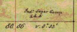
The Barber brothers included many details in their surveys, including this one of an Indian Sugar Camp (T48N R5W).
The Bombardment commenced upon the [Malakoff?] Little Redan at [Carediring Bay?] by the French & the Redan by the English at day break on the 5th & continued to Morn the 8th when the assault commenced.
You will receive the news of the battle by papers to be printed this week & probably this will reach you first. So that I may be the means of giving you intelligence of great importance sooner than you would otherwise get it.
“According to Blatchford there was formerly another considerable village at the mouth of Whittlesey’s Creek, called by the Indians Agami-Wikwedo-Sibiwishen, which signifies “a creek on the other side of the bay,” from agaming (on the other side of a river, or lake), wikwed (a bay), and sibiwishen (a creek).”
~ Collections of the State Historical Society of Wisconsin, Volume 13, pages 430-1
Mum always says that it is useless to try to give early news because you will hear of it sooner or later, and what is the use of writing again so soon? I always that if anything transpires worth relating that then is the time to tell it. I have been to Meeting to hear Mr D all day as I usually do when at home, especially since the baptists [rave?] got their new man Mr Mirriman to preach to them and all creation are running to hear him on the new broom principle. Mum and Am have gone to Cambridge to day to try to find a girl, & I see by her letter to you that she is complaining that I do not [figosure rup?] for her, & that She has too much to do &c&c. I would at any time get a girl for her did I not know that it would only furnish [new?] grounds of complaints. If I got a little girl then there would be trouble for thinking that She could get along with such help, that it was no help at all & made her as much work as it saved, while should I get an older girl she would soon discover certainly as soon as she got rested that she could get along without any or with a little [one?]. It is a fact, that her mind is not as stable and unchanging as the Green Mountains, and in regard to what she says of my not telling her my plans, I will barely say that so long as she does not know them she cannot combat them, which she surely would, whatever they were and in regard to my having run through all the [offices?] &c & taking a pretty clerkshop, it is all news to me coming from her [diseased brain?]
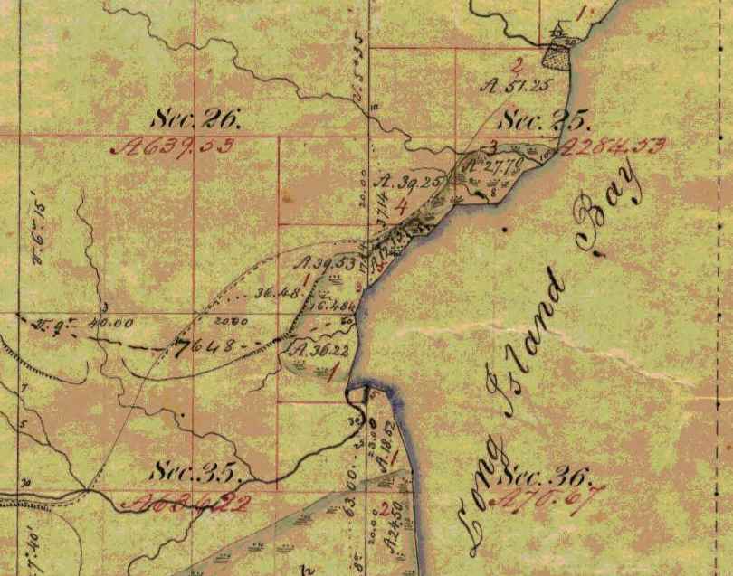
Detail of T48N R5W:
Chequamegon Bay;
an named settlement at the mouth of Boyd Creek;
the Whittlesey Creek National Wildlife Refuge;
and the trailhead of the Grand Footpath.
“Boyd’s Creek is called in Chippewa, Namebinikanensi-Sibiwishen, meaning “Little Sucker Creek.” A man named [Robert] Boyd once resided there, married to an Indian woman. He was shot in a quarrel with another man.”
~ Collections of the State Historical Society of Wisconsin, Volume 13, pages 431-2
“From this place northward, there were Indian hamlets strung along the western shore of the bay. Father Allouez mentions visiting various hamlets two, three, or more (French leagues away from his chapel. Marquette mentions five clearings, where Indian villages were located.“
~ Collections of the State Historical Society of Wisconsin, Volume 13, pages 431
I have been talking with the [boiv’s?] about making my way into cloth for me: and I am convinced that by so doing I can realize 45 or 50 cents per lb for my [westwhoaor?] should I sell it now I could get 34 ¢ per lb for 20 [place?] and only 25 cent per lb for the remainder. It is the very thing that Mum proposed and urged to me weeks ago when I talked of selling it. But now I have concluded to do so she is in distress for fear I shall have to go out there to sell it. I have been thinking of going in [December?] to buy lumber & get it in the ground & make preparations for some improvements on the little farm and I think some good [G??? ???] into [franned?] will be good articles in [enough?] a [country?]. I am in hopes to have [on yes?] cloth or perhaps [?????] cloth & [?????? ?????? or more?]. So my object is to spend my money. Mum says [???] when she sees in prospect [thall?] I [???] go [while?] no longer ago than yesterday she [pevondered?] why I did not go and be doing something on the place in Lancaster and garden from day to day [having?] down one day the plans she had built u the day before &c &c.
The hop harvest is about through and there is not only a small crop but the prices will be low this season – [same when?] I was at the Institute last week and was much surprised with Am’s performance as [cutic?], and if I can get it, will copy it for you that you may see how he is improving.

Detail of a trail between Chequamegon Bay and the Saint Croix River National Scenic Riverway (T48N R5W). This is the Grand Footpath that was discussed in the Comments section of our Oshogay post.
“A short distance from Whittlesey’s Creek, at the western bend of the bay, where is now Shore’s Landing, there used to be a large Indian village and trading post, kept by a Frenchman. Being at the head of the by a, it was the starting point of the Indian trail to the St. Croix country.”
~ Collections of the State Historical Society of Wisconsin, Volume 13, pages 431
I have just looked for it & cannot find it, but I think you will say when you see if that it is pretty tall for one only 14 years of age. I think he is making pretty good progress in his studies though his mother is in great affliction if he is not bowed down to his books every moment. She thinks he should be kept as close to his books as a hired man or girl at their work and if anything closer, because it is not work.
I shall have some [curly?] to carry with me when I leave this town and would like to get it into [law/land?] in some good place for in that way do I think it would be surest and increase fastest.

Detail of a sand stone boulder (T48N R5W).
Still I know not what I shall do. Perhaps I may live and die in Vermont after all, but I want to be in some more productive vicinity than Johnson and some more pleasant place than our old farm in Cambridge. I can work yet but but as for [eritubing?] those hills & rocks I should beg to be [exensed?], though I should regret to have the wood land & sugar place more them all the rest for they [ground me aplenty?] in this or any other place. But oh [such wish her?] the river has made with the banks within the [two ????] years. It makes me sick when I see it and know that it cannot be helped.
“Further north is Kitchi-Namebinikani-Sibiwishen, meaning “Large Sucker Creek,” but whites now call it Bonos Creek. [Boyd and Bono] creeks are not far apart, and once there was a village of Indians there. It was noted as a place for fishing at a certain time of the year, probably in spring, when suckers and other fish would go up these creeks to spawn.
~ Collections of the State Historical Society of Wisconsin, Volume 13, pages 432
I have got to get supper for [Mrs?] Benton and milk and shall have to close this stupid letter. What do you think of having Am & I out there through the winter? Could we find room any where to lie down and could we find [syinge teethes being?] used to say ??. You will see that I am economical of my paper I cast such an enormous square for postage THREE whole cents a week. It is thought any [exlaws out?] Had I been as intent on (spending money as [reprebuted?] I should have gone to Quebec [last ??? in?] Excursion fare only $3.50 from Essex to Quebec & back again. I am sorry that I did not go, as I am chgd with such a desire to spend money.
May you both prosper in all Laudable pursuits & live long is blessing to your parents & the world
G.A.B.
Interior Field Notes
Township 48 North, Range 5 West
Oct. 1855
Notebook ID: INT049W06

Original plat map of T48N R5W. Today, this is the Town of Barksdale.

Survey of T48N R5W by:
Augustus H. Barber, U.S. Deputy Surveyor.

First page of affidavit; continued below.

Chainmen: J. Allen Barber 2nd & George I. Butler
Axeman: Joseph Dennis
(Joseph Dennis was a mixed-blood member of the Lake Superior Chippewa tribe and eligible for a land grant under the seventh clause of the second article of the 1854 Treaty of La Pointe.)

The Barbers’ original field notes for this township were reproduced in 1891 “…for the reason that the original record is becoming illegible by the fading of the inks.“
[c. Oct 12, 1855]
Barbers Camp Oct 1855
Dear Parents
Being unemployed today I have an opportunity though a poor one to write to you once more.
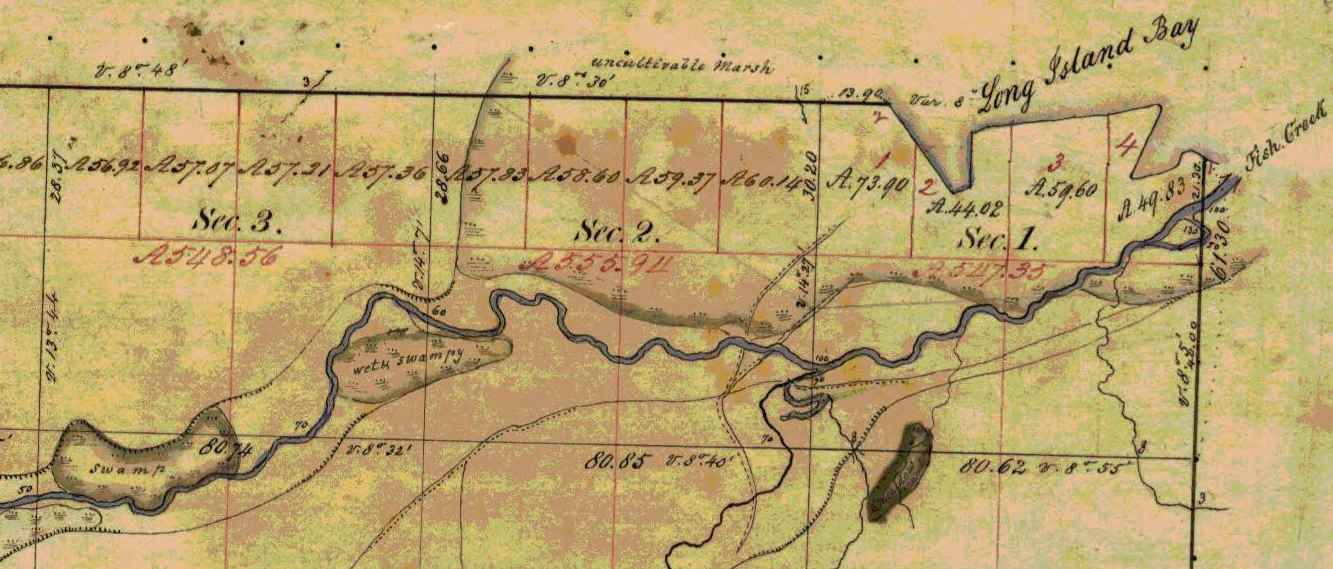
Detail of Fish Creek Slough (T47N R5W).
My health for a few days past has not been good – in fact I have been obliged to be idle the last two days from a kind of disentery very common here and apt to turn to bloody flux. But I am much better today and hope to resume work tomorrow.

Detail of Metabikitigweiag-Sibiwishen; now known as South Fish Creek (T47N R5W).
~ Collections of the State Historical Society of Wisconsin, Volume 13, page 430.
Our party now contains 3 halfbreeds, two to keep camp and one to ax. At first I did not like the idea of having such looking fellows to work for us but they get up good victuals. I don’t inquire how. I have to cook occasionally but I can’t tell how I make it go. Still my pancakes and fried pork and bean soup are generally devoured with an assiduity not often seen out of the woods. The survey is going on pretty well lately. The fourth town will be finished in 4 or 5 days. Then there will be only two more. We are having very good weather now, perhaps it is the beginning of our indian summer which they say is very fine on this lake. I have not yet made up my mind what I shall do this coming winter.

Details of a spring and trails along Fish Creek; and the footpath from Chequamegon Bay to the Mississippi River via Lac Courte Oreilles (T47N R5W).
~ Collections of the State Historical Society of Wisconsin, Volume 13, page 430.
If I make a claim I shall probably live and work on it. I know of a place near the bay for as good a farm as can be made on the lake, good bottom land — some of it producing good hay now. During the summer there has been some emigration to this country but there is room for more yet. The only settlements about this end of the lake are at Superior, Iron river 27 miles this side, Bark Point bay, La point, this bay, Bad river, & Montreal river. At Bark point there is only a fishery and at Bad river a mission.
Lapointe is a queer old town. Standing in the midst of an almost unknown country it presents the appearance of and is in fact about the oldest town I ever saw. Not a horse or carriage track can be seen in the streets and there is not a carriage road leading from the town. The buildings were mostly constructed without sawed lumber and are mostly enclosed with high fences of sharpened posts. Squaws, half breed children, indian dogs and lice are the principal commodities. French and Ojibway are the principal languages spoken.

Detail of water bodies and trails in the vicinity of the Badgerwood CAFO being proposed by Reicks View Farms in current events, described in 1855 by the Barber brothers as “an elevated ridge, much resembling the Mineral ranges of this region” (T47N R5W).
But a more beautiful bay can’t be found than La point bay. I think it is always a safe and accessible harbour.
Oct. 21st. Since writing the above I have recovered my health and been at work about a week.
Love to all
Allen
[Incomplete copy of letter]
[ca. 1855] Nov. 1
Father’s“letter of November 3, 1856, was written during a rough voyage down Lake Superior and Lake Michigan in the famed steamboat ‘Lady Elgin.'”
This incomplete letter was misfiled as 1855; it was from the Fall of 1858. Stay tuned.
Nov 1st The weather is quite different now from what it was 2 years ago yesterday when I left you to come down on the Lady Elgin & to day when we lay shut in by a NorthEaster at Copper harbor.
I have this A.M. recd a letter from Maime Burr & one from her bother. Maime is a beautiful writer both as to matter & manner.
The folks at Lancaster were well except Cyrus who I fear is consumptive.
It is time for me to go to the House & almost time for the Mail to close.
May Heaven bless & protect you
G.A. Barber
Interior Field Notes
Township 47 North, Range 5 West
Oct. 1855-Nov. 1855
Notebook ID: INT049W05

Original plat map of T47N R05W. Today this is the Town of Eileen.
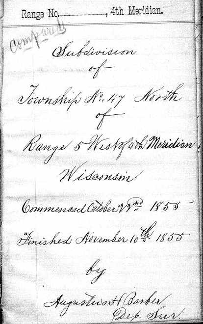
Survey of T47N R5W by:
Augustus H. Barber, U.S. Deputy Surveyor.
General description of T47N R5W.

Chainmen: J. Allen Barber 2nd & George I. Butler
Axeman: Joseph (his mark) Dennis
Affidavit signed by: John W. Bell, Justice of the Peace for LaPointe County.
The Barbers’ original field notes for this township were reproduced in 1885 “… for the reason that the original record is becoming illegible by the fading of the ink.”
Ashland Wisconsin Dec. 16th 1855
Dear Parents
Once more I am seated to assure you of my continued good health and warm affection for the loved recipients of this letter.

Detail of Ashland townsite, Wikwedong, and Fish Creek (T47N R4W).
“Fish Creek is called by the Indians Wikwedo-Sibiwishen, which means ‘Bay Creek,’ from wikwed, Chippewa for bay; hence the name Wikwedong, the name they have to Ashland, meaning ‘at the bay.'”
~ Collections of the State Historical Society of Wisconsin, Volume 13, page 430.
Asaph Whittlesey founded Ashland in 1854 near the ancient village of Wikwedong.

I suppose Augustus has informed you of the completion of his contract. Our summers work hung on rather late as nearly all of the last township was surveyed after the winter had fairly set in. But we are having an easy time of it now. We are keeping house in a little cabin at Ashland about two miles from Bay City. I do all the house work as well as I can by a little stove exactly like our parlor stove and Augustus works at his notes preparing them for the office. As yet I don’t know what I shall do this winter. Between working with Augustus, going below, making a claim and a few other things, I must decide before long. People are pitching upon claims all around me which I might have claimed when surveyed — yet I hold onto to my preemption right in hopes to find a more valuable location. With my knowledge of the country I could make better selections than most of them do and with the means I could secure several valuable tracts. (Eve.) This evening Augustus and I have been singing with Mr. Whittlesey’s folks, who live only a few steps from us. They are intelligent pious folks and very neighborly. Mrs. W. brought us some apple dumplings the other night and has since sent us a whitefish nicely cooked. I suppose they pity our want of skill in the culinary department of housekeeping. I do some baking in the stove which I find a great help. In regard to dish-washing I am rather fortunate as we have dishes enough for six men and can’t use them all at once so I only wash about once in two days.
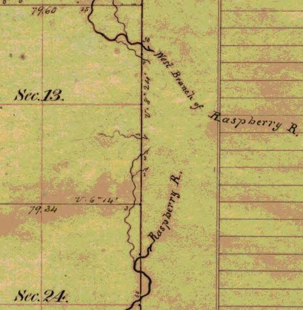
Detail of Raspberry River and West Branch of Raspberry River upstream from Sioux River Slough (T49N R5W).
“Sioux River is a stream located just 4.3 miles from Washburn, in Bayfield County, in the state of Wisconsin, United States, near Sioux, WI. Alternate names for this stream include Miskwimin, Raspberry River and Miskwi Minikan.”
In the Ojibwemowin language, Miskwiwim is Raspberry and Miskwi Minikan is Blood Seed.
The propeller Ogontz survived numerous accidents and a lawsuit upon the Great Lakes.
Butler has left us and gone to Superior intending to go to St. Antony. He did not appear to like the woods very much. Dan Damon of Waterbury had just gone there (to St. Antony). It is announced that there will be preaching here next Sunday by Mr. Warren a young Methodist minister at Bad river mission. I may not be here as we intend to go to La Pointe and probably Superior in two or three days. Provisions are scarce all round the lake I guess. At Superior pork is 25¢ per pound. Here nothing can be obtained by the quantity. At Ontonagon prices are very high. Two cargoes of provisions for Ontonagon have been discharged at some lower port on account of storms. The propeller Ogonts began to unload at Ontonagon but a storm arising she was obliged to put out for a safer harbor and vessel and cargo were much damaged. Last fall a steamboat with passengers for Superior and La pointe landed them at Ontonagon and started back for the Sault but was met by a northeaster and driven back to La pointe. So you see vessels on this lake have to stand round for storms. The bay is partly frozen over. Thermometer this morning 2*-0.

Detail of Sioux River; also labeled as the main branch of the Raspberry River (T49N R5W)
Joseph Alcorn was featured in the Spring of 1855. He appears to have been close to George Riley Stuntz.
Heard today that Jo is at work at Iron River for Stuntz.
I do not know what Augustus will do about surveying this winter. He could probably make it pay better than anything else, I suppose the job lies among the islands which will give plenty of meandering which could be done on the ice at the rate of 9 or 10 miles per day. But nothing can be done about it yet until the channels are frozen over as the water is so full of icebergs part of the time that no small boat could live.
“From all this we see that the bay was from most ancient times the seat of a large aboriginal population. Its geographical position towards the western end of the great lake, its rich fisheries and hunting grounds, all tended to make it the home of thousands of Indians.”
~ Collections of the State Historical Society of Wisconsin, Volume 13, page 433.
The trader of Allen’s yarn was likely present at the 1855 Annuity Payment.
I wish I had time to tell you a lot of yarns about the Indians and indian traders. A Bad River indian came over here today to trade off a beaver skin for whiskey — he got about two quarts for it which made him feel pretty rich yet feeling he had not quite enough he bought a pint more for 50¢ which the trader brought and poured into his keg — but the last pint fortunately was nothing but pure brack water. The same trader one night just after payment took about 75 dollars with only 8 gallons of whiskey well watered.
If we go to La pointe soon this letter will be mailed soon. If not it may stay in this office a week or two.
Please excuse the bad writing, &c, &c.
Your affectionate son
J Allen Barber

Detail of a spring along trail from the Sioux River Valley into the Bayfield Peninsula (T49N R5W).
Dear Mother
I am somewhat in arrears of my usual and promised amount of letter writing but I cannot help it.
Detail of sink holes (T49N R5W).
In a short time I expect to have more favorable opportunities and a better chance to tell you what I shall do and where I shall be this winter. If I stay about here you must not look for letters every week for it will be quite impossible for me to dispatch them oftener than once in two weeks; perhaps longer times will unavoidably intervene. Am well and sound and feel pretty well able to stand a winter here on the lake, though I must own that to survey in mid-winter seems to me like undertaking a pretty [cool?] job. Never mind, to be at work in the woods here is less tedious and less dangerous than to be on the black prairies of southern Wisconsin where roads are covered deep in an hour or two and no sheltering forest nor even fuel to protect the traveler from the bitter winds. You may, I think, be tolerably easy about my health and safety, recollecting that I have been some time in this wild country and enjoyed better health than [two words illegible] others claim, and as for accidents, no place is known to be safe between the walls of the universe, but the peaceable prudent and prompt men may expect to walk in safety in all places as anybody. Besides, there are men here who have shown that they are disposed to remember sundry little accommodations, and if I should need the care of friends at any time I doubt not I should receive all the attention that well disposed strangers could give.
At present I don’t know much about my operations for the immediate future, but expect to know as I go along. We are woefully neglected by the mails of late, but are no worse off in that respect than others.
Hoping this letter will not be as unsatisfactory to you as it looks to me. I am as
Ever Your Affectionate Son
Augustus H. Barber
Interior Field Notes
Township 49 North, Range 5 West
Nov. 1855-Dec. 1855
Notebook ID: INT050W01

Original plat map for T49N R5W.

Survey of T47N R5W by:
Augustus H. Barber, U.S. Deputy Surveyor.

General description of T49N R5W.

Chainmen: J. Allen Barber 2nd & George I. Butler
Axeman: Joseph (his mark) Dennis
Affidavit signed by: John W. Bell, Justice of the Peace for LaPointe County.
The Barber brothers’ original field notes for this township were reproduced in 1891 “… for the reason that the original record is becoming illegible by the fading of the ink.”
[Incomplete copy of letter]
[undated circa 1855]
Detail of Ironton town property with trails to Odanah and to the Penokee Mountains (T47N R1W). This was not part of the Barber brother’s survey in 1855. Today this property is known as Saxon Harbor.
Is there not danger that by the decisions of the Secretary of the Interior lately rendered, you may be thrown out of your Ironton Town property? Or is there perfect immunity from such loss in the hardship of the times that for the present render the property valueless & no temptation to sharks to seize upon them? You can make your shares perfectly safe by ostensibly making your home there & from what you have hinted about the agent I presume it would be no great displeasure for you to sojourn occasionally with his family, at least enough to have your residence called at Ironton.
And this reminds me of seeing the name of your plan in one of the N.E. Counties of Wis. I think in Marquette it was in an advertisement for proposals for carrying mails in Wis. When do you suppose property of any kind will be saleable again about Lake Superior?
One thing is certain, it must be after [this?], if ever, I would like to hear how some of my acquaintances along down the northern shore are thriving & whether property in & around Burlington, Encampments, Rockville, Beaver Bay are commanding fabulous prices as they did last years. I presume thousands of dollars were paid last year to be shown claims & for building shanties on them, by those who are forced to abandon them, & remain where they are in no danger of starving. Has Perry told you that that note could not be paid for lack of money enough in Superior? What did he say about it? How did he expect I want him to get my pay? I expect nothing but that I should lose all that debt, for I am fearful that Carleton will find some way to avoid the payment of it.
Did Perry talk or not as though he wished to have me paid up? & what did he say about its ever being paid? Does he gamble & drink yet? & how do they all appear in Superior? Does the hardship of the time prevent the consumption of such quantities of rot gut as were formerly used?
Are Mr. [Barmite?] & Mr. [McCorble?] there? Is Frasier there? & Mr. Hall the young lawyer, Charly Port, White Perkins & Bradford? If I can only get my affairs in Superior straightened out I can note if the whole place sinks to the “bottom of the sea, the sea, the sea” & half of its inhabitants with it if I could chose who should be saved.
I have written more than I intended, as times hangs so heavily on my hands that I resort to writing as a pasttime.
Again good bye,
G. A. B.
I send you a blank % sheet for your use. I bought squires like this for 34¢ last week & wish I could get some of it to you.
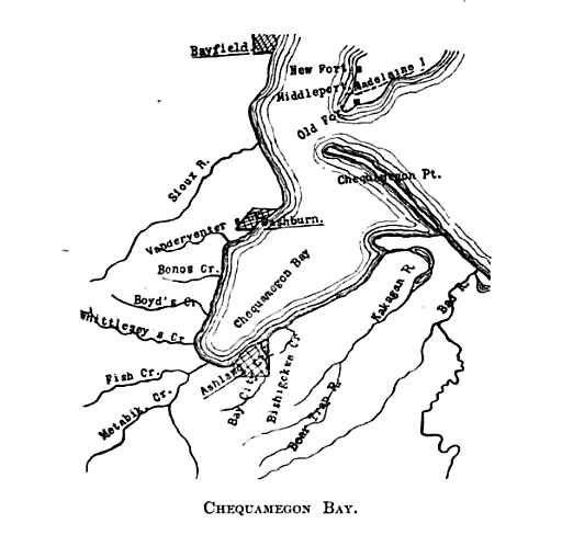
This map is an image from Collections of the State Historical Society of Wisconsin, Volume 13, page 419.
Published in 1895, this map features the area surveyed by the Barber brothers during 1855 surrounded by Bayfield, LaPointe, and Bad River.
After 1855, the Society’s annual reports were included in its Proceedings.
In 1855, the Barber brothers surveyed six townships (216 square miles) along Chequamegon Bay between Bayfield and Bad River.
The available mix of original documents and reproductions of the Barber brothers’ field notes feature these water/land routes; but do not feature any of these ancient villages.
During 1855, did the Barber brothers record these details separately for the State Historical Society of Wisconsin?
To be continued in the Winter of 1856…
By Amorin Mello
In our Penoka Survey Incidents series earlier this year, we followed some of the adventures and schemes of Albert Conrad Stuntz circa 1857. The legacy of Albert’s influential survey still defines the geopolitical landscape of the Penokee Mountains to this day. However, Albert’s work during the late 1850s was relatively minor in comparison to that of his brother, George Riley Stuntz, during the early 1850s. The surveying work of George and his employees started in 1852 and enabled the infamous land speculators and townsite promotors of Superior City to manifest their schemes by early 1854 (months before the Treaty of La Point occurred later that year).
Among the men that worked with George was Augustus Hamilton Barber. Sometime around 1850, Augustus had followed his Grandparents, Aunts, Uncles, and Cousins from the Barber family of Lamoille County, Vermont, to Lancaster in Grant County, Wisconsin. After a short career as a school teacher in Grant County, Augustus came to Lake Superior in 1852 employed by George as a Chainman under his contract with the United States General Land Office to survey lands at the Head of Lake Superior.
Before taking a closer look at the Barber Papers, let’s examine the lives and affairs of other surveyors and speculators along the southwest shore of Lake Superior, starting with George Riley Stuntz and his production of these Exterior Field Notes (June of 1852):


Duluth and St. Louis County, Minnesota;
Their Story and People
By Walter Van Brunt, 1921, pages 64-65.

Portrait of George Nettleton’s cabin on Minnesota Point in 1852 on page 75.
First Settler.– The honor, for both Superior and Duluth, must presumably go to George R. Stuntz. He came in 1852, and settled in 1853. Several were earlier of course, but can hardly be considered to have been legitimate independent settlers. Carlton had been on the ground, at Fond du Lac, for some years, but he was Indian agent; Borup and Oaks had spent their time between La Pointe and Fond du Lac, but were then at St. Paul, and mainly interested in the development of that city, and in fur trading. Wm. R. Marshall stated that he “was on the lake as early as 1848,” but not to settle and he did not come again until 1857. Wm. R. Marshall and George R. Stuntz were fellow-surveyors, in federal pay, “back in the ’40s,” but Marshall did not seek to take the place of Stuntz as premier pioneer at the head of Lake Superior. As a matter of fact, although “on the lake as early as “1848,” Marshall did not then get nearer to Duluth than La Pointe, where he met “Borup and Oaks, the principal traders, Truman Warren, George Nettleton, Cruttenden, Wattrous, Rev. Sherman Hall, E. F. Ely and others.” It is quite possible that Stuntz was with Marshall in 1848, for that was the year in which Stuntz first entered Minnesota territory “having charge of a surveying party that was working near Lake Pepin and in what is now Washington County.”
The “Heart of the Continent.”– George R. Stuntz prepared the way for the first attempt at white settlement at the head of Lake Superior. He surveyed the land on the Wisconsin side, within a year of beginning which survey, in 1852, the first settlers began to appear. George R. Stuntz came by direction of George B. Sargent, who at the time was surveyor-general of the Iowa, Wisconsin and Minnesota district for the federal government, his headquarters being at Davenport, Iowa. In that year, states Carey, “he surveyed and definitely located a portion of the northeastern boundary line between Minnesota and Wisconsin, starting from the head of navigation on the St. Louis River, at Fond du Lac, and running south to the St. Croix River.” Stuntz himself stated: “I came in 1852. I saw the advantages of this point (Minnesota Point) as clearly then as I do now (1892). On finishing the survey for the government, I went away to make a report, and returned the next spring and came for good. I saw as surely then as I do now that this was the heart of the continent commercially, and so I drove my stakes.”
![Group of people, including a number of Ojibwe at Minnesota Point, Duluth, Minnesota [featuring William Howenstein] ~ University of Minnesota Duluth, Kathryn A. Martin Library](https://chequamegonhistory.com/wp-content/uploads/2015/06/howenstein-minnesota-point.jpg)
Group of people, including a number of Ojibwe at Minnesota Point, Duluth, Minnesota [featuring William Howenstein in 1872?] ~ University of Minnesota Duluth
The Vanguard.– He did not come alone, needing of course assistants in the work of surveying, but he was in charge of the work, Gand necessarily takes first place in the accounting. William C. Sargent, son of George B. Sargent, stated in 1916, that his father “came here (Duluth) first in 1852 with George R. Stuntz and Bill Howenstein,” and goes on to state “a word of those two grand men, George R. Stuntz and Bill Howenstein.” He believed that “to George R. Stuntz, more than to any other man belongs the honor (of) opening up that region,” and of Howenstein, he said: “And old Bill Howenstein, one of the best ever, and always my very good friend, a kindly body, with a quaint dry humor unsurpassed and seldom met with in these later days. I had many an interesting chat with him, in his home on Minnesota Point, that he built in 1852, and lived in until his death, some years ago.” Bill Howenstein, undoubtedly was of Stuntz’ party in 1852, but it is doubtful whether he built a log house on Minnesota Point in that year. As to General Sargent’s visit in 1852. If he did come then, it was probably only a flying visit. His interest in the head of Lake Superior in 1852 reached only to the extent of directing Stuntz to survey it. He, himself, had the surveying business of three states to attend to.
The New York Times
[December 11, 1852]
The Region about the Southwest End of Lake Superior.
Mr. Stuntz, of Grant County, Wis., has been deputed by the general Land Surveyor of this Northwest District to lay off such a tract of land about the southwest point of the lake into townships and sections, as emigrants will earliest require. He returned via La Pointe and Stillwater last week. We have obtained from him some new views of that region. From Fond du Lac, a trading post situated 11 miles inland on the St. Louis River, eastward, for perhaps 50 miles, the margin of the lake is a flat strip of land reaching back to a rocky ridge about 11 miles off. The soil of this flat land is a rich red clay. The wood is white cedar and pine of the most magnificent growth. The American line is beyond the mouth of the St. Louis and Pigeon rivers. It evidently abounds in copper, iron and silver. The terrestrial compass cannot be used there, so strong is the attraction to the earth. The needle rears and plunges “like mad.” Points of survey have to be fixed by the solar compass.
The Indian and half breed packmen have astonishing strength. One Indian, who is described by the others as being as large as two men, carried for a company of 11 men provisions for ten days, viz: one barrel of flour, half barrel of pork and something else, beside the utensils. Mirage is a common phenomenon is Spring and Summer. For the bays not opening as soon as the main lake, or not cooling so early, an object out on the lake, is viewed from the shore, through a dense medium of air and a thin medium. Hence is a refraction of rays which gives so many wonderful sights that the Chippewas call that the spirit or enchanted land. Sail vessels which are really 40 miles off, are seen flapping and bellying about almost within touch. Turreted Islands, look heavy and toppling towards the zenith. Forests seem to leap from their stems and go a soaring like thistles for the very sport of it.
The ice did not leave some of the bays till the 10th of June. The fish are delicious, especially the salmon trout. But little land game. Mr. Stunts calculates on wonderful enterprises in that country after the opening of the Saut Canal.
Mr. S. describes La Pointe a town of the Lake, as being situated at the head of a bay some 25 miles from the high lake, and secluded from the lake by several islands. He saw there a warehouse 300 feet long, built of tamarac poles, and roofed with bark. This building is very much warped by the pressure of age ; it is entered by a wooden railway. The town is dingy and dreary. He saw a most luxurious garden by the former residence of Dr. Borup. It contained a variety of fruit trees and shrubs, such as plums, cherries, apples, pears, currants, &c.

Cover of Stuntz’s Exterior Field Notes (August-October 1852) ~ Wisconsin Public Land Survey Records: Original Field Notes and Plat Maps

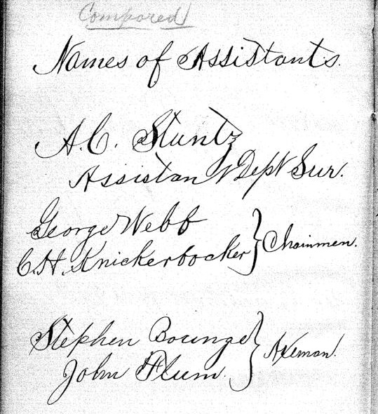
George Riley Stuntz was also assisted by his brother Albert Conrad Stuntz as well as the African-Chippewa mixed-blood Stephen Bonga employed as an Axeman. To learn more about the interesting Bonga (Bonza) family and Stephen as “the first white child born at the head of Lake Superior,” read pages 39-41 of The Black West by William Loren Katz (1971), and pages 131-34 of Black Indians also by Katz (2012).
The Eye of the North-west: First Annual Report of the Statistician of Superior, Wisconsin
By Frank Abial Flower, 1890

Portrait of Stephen Bonga, page 7.
GEORGE R. STUNTZ, DEPUTY U. S. SURVEYOR [pages 50-52]

Portrait of George Riley Stuntz, page 26.
In 1852 George R. Stuntz took a contract to run the township lines in this part of the country, including the state boundary, and filed with the land-office at Dubuque a rude map of the head of the lake, on the Wisconsin side, in December of that year. He took a new contract and returned in the spring of 1853 to survey the copper range around Black River, a few miles south of Superior. He brought seeds with him and planting them on the Namdji, raised a quantity of vegetables; they grew to great size. he also built a trading-post on Minnesota point near the present light-house, and a mill on Iron River in Bayfield county. In respect of these operations W. W. Ward writes from Morley, Mo.:
The first lumber of any description produced locally, other than by “Whip sawing”, was at Iron River, Wisconsin about forty miles from Superior on the South Shore of Lake Superior.
George R. Stuntz with William C. Howenstein, Andrew Reefer and George Falkner built and operated a water power “up and down” sawmill at the falls on Iron River about a half a mile from the Lake, capable of cutting three thousand feet of lumber a day. The writer has several 1 1/4 inch absolutely “clear” White Pine boards 24 and 26 inches wide and 18 feet long that were originally stored in a loft to be used in building a skiff. This mill was built in 1854 and the lumber was floated up the Lake to Superior, Oneota and Fond du Lac…
~ Superior, Wisconsin, papers, 1831-1942 ([unpublished])
From “A Pioneer of Old Superior” by Lillian Kimball Stewart
“In the summer of ’54 the Sam Ward plying between the Sault and any port on Lake Superior, brought on every trip a goodly number of emigrants, speculators, and tourists, bent on seeing the new “city” of Superior. Stuntz’s dock was located near an Indian village, so that every traveler as well as every piece of freight or baggage was subject to inspection by braves, squaws, and papooses before receiving a passport to the shore across the bay…”
~ Superior, Wisconsin, papers, 1831-1942 ([unpublished])
“It was in the spring of 1853 that Mr. Stuntz, Deputy U. S. Surveyor, received his second contract to survey and run the township lines taking in the range around Black River Falls, a portion of Left-hand River country and that part where Superior now is. In the latter part of April that year he organized a party – viz., Nat. W. Kendall, James McKinzie, Pain Bradt, James McBride, Harvey Fargo, Wm. H. Reed, John Chisholm, Joseph Latham, Augustus Barber, and your humble servant. Procured three birch-bark canoes and supplies at Stillwater, Minn.: left there the first day of May, passed up the St. Croix River to its head, made a portage of about two and a half miles into the headwaters of the Brule River, down said river into Lake Superior, thence up the lake to what was called the entry of St. Louis Bay [now Superior Bay], and landed on Minnesota Point in the early part of June. At that time there were no white settlers in this end of the lake – all Chippewa Indians and ‘breeds’ – scarcely a stick missing on that side of the bay where Superior City now stands. We finished the surveying contract and went in early fall down to Iron River, built a double log-shanty, and made other preparations for the construction of a saw mill. Here the first lumber was made at the head of the lake and the first road opened through to the settlement on the St. Croix. The following February, Mr. Stuntz having a trading-post on Minnesota Point [then Stuntz’s Point], I went there and assisted in building a block-house and steamboat pier, and found improvements and a few log-shanties built where old Superior now is located.”
[…]
HUSTLING FOR TOWNSITES [pages 58-60]
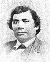
Vincent Roy Jr. ~ Life and Labors of Rt. Rev. Frederic Baraga by Chrysostom Verwyst,
VI. – Superior.
Vincent [Roy Jr.] had barely emerged from the trouble just described when it was necessary for him to exert himself in another direction. A year or so previously he had taken up a claim of land at the headwaters of Lake Superior and there was improvement now on foot for that part of the country, and danger for his interests.
The ship canal at Sault St Marie was in course of construction and it was evidently but a question of days that boats afloat on Lakes Huron and Michigan would be able to run up and unload their cargo for regions further inland somewhere on the shore at the further end of Lake Superior, at which a place, no doubt, a city would be built. The place now occupied by the city of Superior was suitable for the purposes in view but to set it in order and to own the greatest possible part of it, had become all at the same time the cherished idea of too many different elements as that developments could go on smoothly. Three independent crews were struggling to establish themselves at the lower or east end of the bay when a fourth crew approached at the upper or west end, with which Vincent, his brother Frank, and others of LaPointe had joined in. As this crew went directly to and began operations at the place where Vincent had his property it seems to have been guided by him, though it was in reality under the leadership of Wm. Nettleton who was backed by Hon. Henry M. Rice of St. Paul. Without delay the party set to work surveying the land and “improving” each claim, as soon as it was marked off, by building some kind of a log-house upon it. The hewing of timber may have attracted the attention of the other crews at the lower end about two or three miles off, as they came up about noon to see what was going on. The parties met about halfway down the bay at a place where a small creek winds its way through a rugged ravine and falls into the bay. Prospects were anything but pleasant at first at the meeting; for a time it seemed that a battle was to be fought, which however did not take place but the parceling out of ‘claims’ was for the time being suspended. This was in March or April 1854. Hereafter some transacting went on back the curtain, and before long it came out that the interests of the town-site of Superior, as far as necessary for efficient action, were united into a land company of which public and prominent view of New York, Washington, D.C. and other places east of the Mississippi river were the stockholders. Such interests as were not represented in the company were satisfied which meant for some of them that they were set aside for deficiency of right or title to a consideration. The townsite of the Superior of those days was laid out on both sides of the Nemadji river about two or three miles into the country with a base along the water edge about half way up Superior bay, so that Vincent with his property at the upper end of the bay, was pretty well out of the way of the land company, but there were an way such as thought his land a desirable thing and they contested his title in spite of his holding it already for a considerable time. An argument on hand in those days was, that persons of mixed blood were incapable of making a legal claim of land. The assertion looks more like a bugaboo invented for the purpose to get rid of persons in the way than something founded upon law and reason, yet at that time some effect was obtained with it. Vincent managed, however, to ward off all intrusion upon his property, holding it under every possible title, ‘preemption’ etc., until the treaty of LaPointe in the following September, when it was settled upon his name by title of United States scrip so called, that is by reason of the clause, as said above, entered into the second article of that treaty.
The subsequent fate of the piece of land here in question was that Vincent held it through the varying fortune of the ‘head of the lake’ for a period of about thirty six years until it had greatly risen in value, and when the west end was getting pretty much the more important complex of Superior, an English syndicate paid the sum of twenty five thousand dollars, of which was then embodied in a tract afterwards known as “Roy’s Addition”.
~ Biographical Sketch – Vincent Roy Jr; Vincent Roy Jr. Papers.
Up to the time of the survey in the spring of 1854 all was chaos as to lands west of the claims of Robertson, Nelson, Baker and their party. There could be no titles or bona fide purchases, as only the mouth of the Nemadji had been surveyed. There were really three “townsite” companies— Robertson, Nelson and Baker, with their associates J. A. Bullen, J. T. Morgan, E. Y. Shelly, August Zachau, C. G. Pettys, Abraham Emmett, and perhaps others, forming one which had the surveyed lands next to the Nemadji. West of them were Francis Roy, Benjamin Cadotte, Robert Bothwick, Basil Dennis, Charles Knowlton and nearly a dozen half-breeds, mostly brought from Crow Wing by Nettleton in the interest of what was known as the “Hollinshead crowd”—Edmund and Henry M. Rice, George L. Becker, Wm. and George W. Nettleton, Benjamin Thompson, James Stinson and W. H. Newton. Still farther west were Benjamin W. Brunson, A. A. Parker, R. F. Slaughter, C. D. Kimball, Rev. E. F. Ely, George R. Stuntz, Bradley Salter, Joseph Kimball, Calvin Hood, and others who proposed to call their town Endion—”Ahn-dy-yon,” the Chippewa for “home.”
B. W. Brunson, still a resident of St. Paul, has described the contest in writing. He says:
“Believing Superior would become of importance I went there in February, 1854, with R. F. Slaughter. We found some Ontonagon parties had claimed on the bay and we bought an interest in their claims and began to lay out a city and make improvements. While surveying the town, and when we had the same so far completed as to make a plat of it, the township having been subdivided by a good surveyor, then it was that Vincent Roy, Basil Dennis, Charles Brissette and Antoine Warren, accompanied by twenty-one other half-breeds and some four or five white men, headed, led and directed by one Stinson and one Thompson, who were acting for themselves and as agents of the company, came upon the lands to make their claims and avail themselves of pre-emption rights as citizens of the United States. These men were in the employ of the company for the purpose of making claims, and there was a claimant for each and every quarter-section as fast as the surveyor set the quarter-post. They had commenced the day before, with or at the same time the surveyor commenced his work. The timber being dense and there being a strong force, they were able to build an 8×10 cabin and cover it with boughs, upon each quarter, and then overtake the surveyor before he could establish the next quarter, thus taking the land as they went, and in that manner were progressing when they came upon the land marked out and occupied by us.“
The meeting of the two hostile parties occurred on the banks of the deep slough in what is now called Central Park. Nothing but the timidity of the half-breeds prevented bloodshed. Brunson was armed and intended to, and did stand his ground. Thompson, one of the pluckiest of men, was also armed, having two revolvers, and was prepared and intended to proceed. The Indians, not being armed, did not wish to engage in a battle where the leaders only were prepared to fight; and so there was no physical conflict, though a state of chaos and bad feeling continued for some time. Several cabins were demolished, Brunson’s party entirely cutting in pieces a house built by Basil Dennis on the ground now occupied by Dr. Conan’s fine residence.
A long legal contest followed. Finally in 1862-63 patents issued from the government to three men—S. W. Smith, Lars Lenroot and Oliver Lemerise—chosen as trustees of the townsite for the benefit of actual occupants. Thus those who claimed to be proprietors of, but not settlers on the townsite, lost their lands as well as their labor. In the winter of 1853-54 Henry M. Rice asked the Commissioner of the General Land Office whether, when lands which had not been surveyed were claimed for a townsite they would be liable to pre-emption as soon as the survey should be made. The answer was in favor of pre-emption; and that is how those who with Brunson put money into Superior City townsite lost it. The actual settlers got the townsite, the patent being made to the three trustees named who divided the plat, containing 240 acres with riparian rights in Superior Bay, and deeded lots to occupants and purchasers. It may be proper to mention here that a little plat of thirty-four acres, with riparian rights in the bay, and known as Middletown, went through a similar siege of litigation and was finally patented to three trustees —Urguelle Gouge, Louis Morrisette and Nicholas Poulliott—for the benefit of actual occupants. These decisions did not come until the “city” had collapsed and the land become nearly worthless.
The New York Times
[June 19th, 1858]
WESTERN LAND FRAUDS.
More Blood in the Body than Shows in the Face – Land Frauds in the Northwest – The Superior City Controversy – Pre-emptions by Swedes and Indians
Washington, Thursday, June 17, 1858.
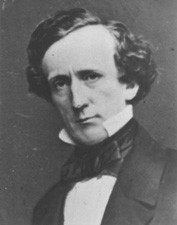
Senator Henry Mower Rice
~ United States Senate Historical Office
There are some interesting matters here besides what takes place in Congress, and I propose from time to time to touch upon them. An expenditure of $60,000,000 per annum does not cover all the pickings and stealings that “prevail” in our hereabouts. Senator RICE did not tell all he knew about land-office operations, when he testified to the value of the Fort Snelling property. Nobody is better aware than he that the tract would be much better to cut up into town lots than Bayfield was when he bought it for a few cents an acre, and sold it for hundreds of dollars. If we could find out all that Senator BRIGHT knows of these matters, one could learn how to become a millionaire at very small expense of brains or labor. Indian treaties and land-office jobbing have made more men rich than care to tell of it – ask General CASS if this is not so.
Seeing a bushel-basket of papers in the Interior Department the other day, I was curious to know what the kernel might be to all that rind, and made inquiry in the premises. I was told that they enveloped the case of Superior City. I cast my eye over some of them, and noticed that an argument was filed on behalf of one of the parties by Mr. Senator BRIGHT – or rather with Senator BRIGHT’S indorsement. This whetted my desire of knowledge, and I ran my eye over the paper in question, which was from the pen of a Minnesota Judge and was without exception the richest document I ever saw intended for a judicial or administrative tribunal. The substance of it was that the opinion of the Attorney-General CUSHING in the case was absurd, the adoption of his views by the Interior Department preposterous, and the action of the local Land office at Superior, in defining the status of certain half-breed Indians on the most abundant testimony, corrupt. It was clear enough that such a document required at least a senatorial indorsement to justify its reception. Nobody can suppose for a moment that Senator BRIGHT has any interest in the result of the case, or that he expected to influence the judgement of his friend, HENDRICKS, (Commissioner of the General Land Office,) by appearing in it. That would be too strong an inference to draw from so meek a fact ; and yet the malicious might suggest it as an apprehension.
Original Proprietors of Superior featuring James Stinson, Benjamin Thomson, Dr. W.W. Coran, U.S. Senator Robert J Walker, George W. Cass, and Horace Bridge. Featured in The Eye of the North-west, pg. 8.
From the printed argument of Senator BRIGHT’S friend, and from a private abstract of the testimony in the case, and a few items I have picked up in the Land Office, I think it will be in my power to indite an epistle that may excite some attention. At the Southwestern extremity of Lake Superior, there is a tract of land, which is expected some day to become the cite of a large city. Being aware of its great advantages for this purpose, a St. Paul speculator by the name of THOMPSON, and a Canadian operator by the name of STINSON, undertook to possess themselves of it as long as as in the early part of General PIERCE‘S administration, by vicarious preemptions. In this plan they were assisted by some official gentlement, who shared in the spoils, and patents were ground out in double-quick time, or certificates issued to Swedes and Indians for the benefit of this STINSON and THOMPSON, and their associate speculators.
More Proprietors of Supeior from The Eye of the North-west, pg. 9.
In the Summer of 1854, this Mr. STINSON, headed a gang of Swedes and led them from Swede Lake, in the Territory of Minnesota, to Lake Superior, guiding them in person to the tracts he wished them to preempt. These men were ignorant of our language and of our laws, and were used by STINSON to “settle” their tracts, “prove up” their claims, and “convey” to him, the said STINSON, without knowing either the frauds they were practicing, or the rights which they might have secured to themselves if they had been acting in good faith. In the Land Office at Hudson, where these frauds were perpetrated, there was a notary public, who drew the deeds to STINSON, got the signatures of the Swedes to them and took the acknowledgements, immediately after the preemption oath had been administered – the Swedes thinking the whole operation a part of the preemption process. The terms were said to be $30 a month, and a bonus of $15 on the consummation of the bargain. The names of these Swedes were Aaron Peterson, Martin Larson, Peter Nelson, John Johnson, Sven Magnassan, Lorenz Johnson, Peter Norell, Sven Larson, Andreas Senson, Johannes Helon, Johannes Peterson, and Peter Erickson. These “preemptors,” for their own benefit, all “proved up” at Hudson, and the very same day they made conveyances to STINSON. The same thing is true of another Swedish invasion that was made in the Summer of 1855. In that year three Swedes – Old Westerland, Andrew Walmart, and Israel Janssen – commenced their settlements June 11, proved up June 22, and conveyed to STINSON June 22 – eleven days being sufficient for the whole operation. The records of the Land Office at Superior, and of the Register of Deeds of Douglas County, show these facts. They are well known in the General Land Office.
But Mr. STINSON did not operate through Swedes alone. He and his friend THOMPSON worked with half-breed Indians also. In March, 1854, he and THOMPSON followed up the Government Surveys with a gang of Chippewa half-breed Indians. The whole gang made preemptions in Douglas County, under the guidance of THOMPSON and STINSON, who hired them at La Pointe, and convered a large portion of a township with their fraudulent pre-emptions, which were proved up simultaneously, and simultaneously conveyed to the attorney of THOMPSON and STINSON. The names of all of this gang appear on the tract books in the General Land Office. These were Joseph Lamoureaux, Joseph Defaut, Joseph Dennis, Joseph Gauthier, Francis Decoteau, John B. Goslin, George D. Morrison and Levi B. Coffee, all preemptors for these land-sharks. There were three or four more half-breeds in the gang, who ran foul of some eight or ten American citizens who were seeking to save a slice of this Territory from Swedish and Indian preemption, and lay out a town site there under the law. This was the origin of the Superior City controversy, which has been pending some three or four years in the various land offices, and which has accumulated the basket of papers which first drew my attention to a case of such interesting dimensions. The contest is nominally between three or four Chippewa half-breeds claiming some three hundred acres as a town site. But the Indians are not merely bogus citizens, they are bogus pre-emptors in the bargain, for they were the hired men of THOMPSON & STINSON.
Mr. CUSHING decided in this controversy, before it was so settled by the Dred Scott case, that a half-breed Indian, receiving annuities as such, recognized as a dependent of a tribe, and the beneficiary of treaty stipulations, could become a citizen of the United States only by some positive act of Federal legislation ; that he could not, of his own volition, or by the laws of a State, change his condition from that of an Indian to that of a Federal citizen. Strange as it may seem, it appears that this part of the Dred Scott is repudiated by Mr. Commissioner HENDRICKS, who thinks a state cannot make a Federal citizen of a man with a drop of negro blood in his veins, but that the Commissioner of the General Land Office may naturalize Indians, ad libitum, without statute or judgement to sustain him.
I am curious to see how this controversy will be decided. The General Land Office upheld STINTSON’S Swedish preemption, on the ground that the frauds were discovered too late for the Commissioner to interefere. Whether or not STINSON hasmade any negro preemptions does not appear. It was too cold at the end of the lake for negroes to flourish much. But now it is to be settled in a case where the attempted frauds have been seasonably discovered, whether or not a Canadian adventurer can preempt whole townships of the Public Lands by the agency of a gang of half-breed Indians, and procure patents for them when the facts are known to the Federal authorities.
The pre-emptive right. Homesteads.
~ Superior, Wisconsin, papers, 1831-1942 ([unpublished])

Detail of Superior City townsite at the head of Lake Superior from Stuntz’s 1854 Plat Map of Township 49 North Range 14 West.
Early history of Superior should make mention of this right of acquisition, since there under, titles to government land were derived. Any qualified person might acquire title to one hundred and sixty acres of land by settling thereon, erecting a dwelling and making other improvements. Such person was to be twenty-one years of age, either male or female, or the head of a family whether man or woman.
Proof of each settlement was required to be made on a certain day at the United State Land Office and upon the payment of two hundred dollars with the taking of a required oath, the preemptioner got his one hundred and sixty acres of land.
But the whole proceeding, was far from straight, as a general thing, and in fact often amounted to a fraud.
“In the first place, Superior was backed by a powerful company of Democratic politicians and Government bankers in Washington, while the northern and northeastern portions of the state were still held by the Indians. This Superior company sought a connection with the Mississippi river, to obtain which they urged in congress the passage of a land grant bill, offering ten sections to the mile to aid in the construction of a railroad from Milwaukee to some point on Lake St. Croix, on the western boundary of the state of Wisconsin.”
~ History of Duluth and St. Louis County, Past and Present,
Volume 1, page 230.
Hence the whole country, in and about Superior, was dotted with preemption cabins, which were little more than logs piles up in walls, without floors, or windows, often with brush for a roof, a hole therein for a chimney and perhaps for a door. A slashing of half an acre or so of trees was the “improvement” so called. A very barbarous travesty, it was, upon a white man’s home and farm. Here is an instance, where as was said, a certain doctor of divinity laid claim to a quarter section of land, now in the midst of this city.
One day he sought “to prove up” his preemption, and one Alfred Allen was his witness, and they asked Allen, “Was the pre-emptions shanty good to live in?“, the law requiring a good habitable house on the claim. And Alf said “Yes, good for mosquitoes.” The Reverend said “Pshaw! Pshaw!” Meanding to upbraid or caution the witness who thereupon only protested and adjured the harder. The difficulty was somehow smoothed over, through some mending of the proofs, and perhaps connivance on the part of persons charged with administration of the United States land laws.
Nevertheless, it is interesting to member that upon rude and rough proceedings, such as are herein alluded to, rest at bottom the titles and claims to everything we own in the nature of lots, blocks, and land.
From: Statements of Hiram Hayes. Mr. Hayes came to Superior in 1854.
History of Duluth and St. Louis County, Past and Present, Volume 1
By Dwight Edwards Woodbridge, et al, 1910
GEORGE R. STUNTZ. [pages 229-231]
One of the earliest settlers at the head of the lakes was Mr. George E. Stuntz, who a short time ago joined the great majority. Before his death Mr. Stuntz wrote of his pioneer experiences as follows:
“In July, 1852, I came to the head of Lake Superior to run the land lines and subdivide certain townships. When I arrived at the head of the lakes there was nothing in Duluth or Superior. There was no settlement. The old American Fur Company had a post at La Pointe, at the west side of Madeline Island.
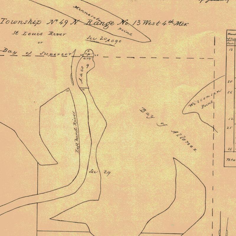
Detail of Minnesota Point from Stuntz’s Exterior Field Notes (August-October of 1852).
“In 1853 I got the range subdivided, and also in Superior, townsite 49, range 13. During the same year, later, in my absence, there came parties from the copper district of upper Michigan and located claims upon the range. They were principally miners. During the same year I built a residence on Minnesota Point under treaty license before the territory was sold to the Government. At that time there were only missionaries or license traders in the tract, as it belonged to the original Indian territory. In 1852, at Fond du Lac, there was a trading post and warehouse, in which I stored my goods on my arrival. In the fall of 1853 I bought three yoke of cattle and two cows at St. Croix Falls and brought them to the mouth of the Iron river, and had to cut a road thirty miles through the dense forest so as to get the oxen, cows and cart through. Later in the fall of 1853 I came through with an extra yoke of oxen, buying provisions, etc., and on coming up to Superior I found quite a settlement of log cabins. These settlers were anxious to get to the United States land office, then at Hudson, Wis. A dense forest intervened. We organized a volunteer company in January, 1854, to cut a road from old Superior to the nearest lumber camp on the St. Croix river, I furnishing two barrels of flour, provisions, pony and dog train, necessary to carry the provisions for a gang of seventeen men. The road was completed in twenty days, the snow being at that time two feet deep. This cut through a direct road to Taylor’s Falls and Stillwater. In 1854 I completed a mill on the Iron river and employed a man to superintend it, and I remained at Minnesota Point, my trading post, where I had first taken out the license. In the same year I took a contract to subdivide two townships located in Superior, townships 48-49, range 15, and afterward I attended the treaty at the time the Indians sold this country to the Government.
Before the 1854 Treaty of La Pointe could be ratified in Washington, D.C., the oral description agreed upon during the negotiations for exterior boundaries of the Chippewa treaties had to be surveyed with the tribe, documented, and delivered to Washington, D.C. before 1855. It is not clear who was involved with the exterior boundaries of these reservations; whether it was Stuntz, Barber, and/or others from their party.
“There were 5,000 Indians present with their chiefs. It was the biggest assemblage of Indians ever held at Lake Superior at this period of the country’s history. It took a month to pacify the troubles that grew among the different tribes in regard to their proportionate rights. This treaty was sent to congress September [30], 1854, and was ratified and became law in January, 1855.
To be continued in 1854…
Penokee Survey Incidents: Number VII
April 16, 2015
By Amorin Mello
January 5, 1878.
The Survey of the Penoka Range and Incidents Connected with its Early History.
—
Number VII.
Upon the arrival of Gen. Cutler and myself at Milwaukee, December 25th, 1857, we found that the affairs of the Wisconsin & Lake Superior Mining and Smelting Company were in a very different condition, financially, from what they were when we left home, nearly eight months before. The great commercial storm, that, like a tidal wave, had swept over the country that year from Maine to California, had left its mark in wrecking many of the best business men of the “Cream City,” as well as elsewhere. Among these were some of the original stock holders of our company, who, unable to stand their assessments any longer, had, previous to our arrival, given place to others as green as they were originally themselves. Even some of the new stock holders were also subsequently compelled to sell out to other parties, not being any better able to respond when the call for more money was made upon them, than had their illustrious predecessors, thereby losing not only all they had invested, but what they had in prospect to make, as well.
Among those who stepped into the trap at this time and who remained in to the end were Messrs. Green & Button, who yet hold stock, John W. Pixley, Simeon N. Small, J.B.D. Coggswell and R.B. Bell, a one-horse banker who came to our city about that time. The outs being John Lockwood, who, in imagination, had been a large capitalist, and worth at least two hundred thousand dollars; but whose liabilities so far exceeded his ability to pay when brought to the front as to make him a hopeless bankrupt, was, with Palmer, Greves and Cummings, compelled to retire.
The amount of money expended up to this time, in order to obtain possession of this imaginary bonanza had not only floored these gentlemen, leaving them high and dry upon the shoals of commercial bankruptcy, but had so far exceeded the amount originally contemplated, as to make those of us who remained fear the wrath to come in view of the stringency of the money market, as well as the general stagnation of business, particularly, as from past experience, it was not possible to calculate with certainty what further amounts would be required, in order to insure success. A large force was still upon the Range, neither could it be withdrawn until the lands were entered, except at the risk of losing all that had been done. These men were to be paid as well as fed during the winter, which would of itself, require no inconsiderable sum; besides we must pay the Government for the land. Money must be raised, consequently, to go back was impossible; to go forward, equally so. But to go ahead was our motto, and the amount necessary for these purposes was at once raised by assessment upon those of us who were yet solvent, and the “pot kept a boiling.”
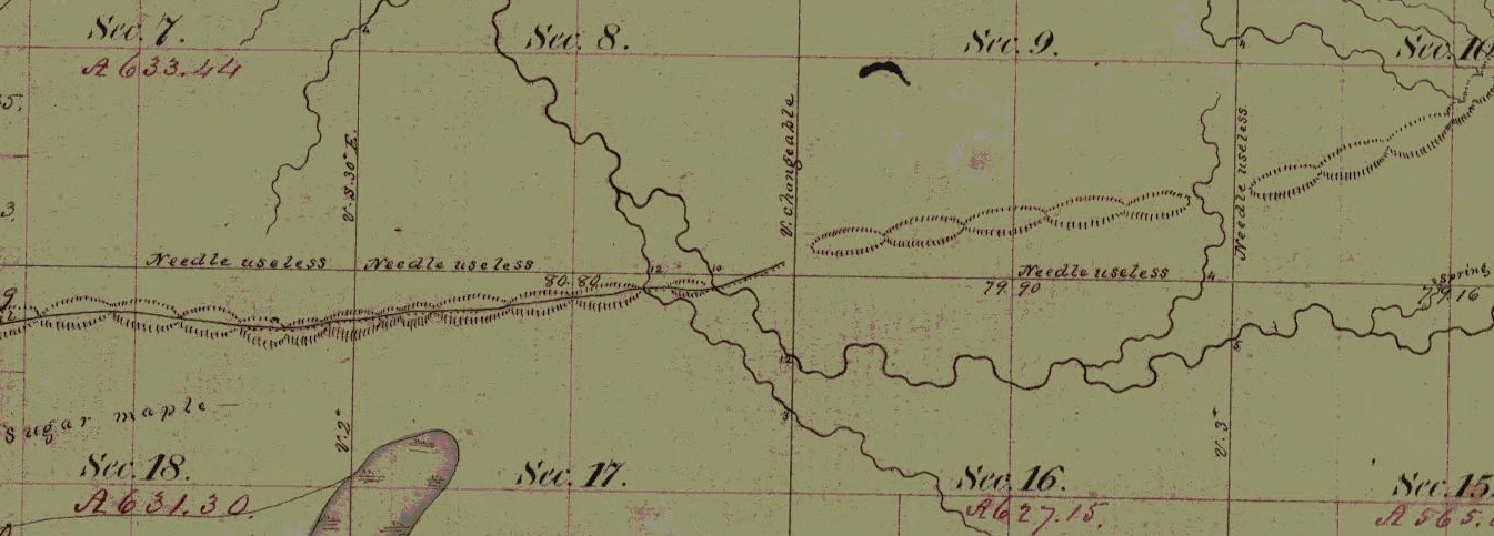
Wheelock’s unmarked townsite claim at Ballou Gap in the Iron Range with sugar bushes, artesian springs, and useless compasses. (Detail of Stuntz’s survey during September of 1857)
During the winter the improvements upon the Range spoken of as contemplated were pushed steadily forward under the skillful management of A.B. Wheelock, who was in every way, the man for the place, as in addition to completing the two block houses in good shape, twelve hundred pounds of sugar and forty gallons of molasses were made under his direction during the spring. The tubs for holding the sugar and syrup were all made during the winter at Penoka, by that Jack of all trades, Steve Sanborn, who could do almost as good work with a hatchet, knife, saw, auger and draw shave, as half the coopers and carpenters in the country, with a full set of tools.
Perhaps a short sketch of this singular mortal, so well known to many of Ashland’s early men, may not be uninteresting to your readers.
In height he was about five feet six inches, broad shoulders, arms long and sinewy, head large and wide; dark complexion, long, dark brown hair, blue eyes, face smooth and beardless, high cheek bones, long, wide, projecting chin, that was always getting up a muss with his nose, which was also long, and slightly hooked. He walked heavily, his knees usually about six inches in advance of his toes, giving his legs, which were bowed, the shape of an obtuse angle. Such was his personale. His conversational powers were not of the highest order – in fact he seldom spoke to any one; was fond of hunting and trapping, a vocation he usually followed every winter, remaining out alone for weeks together, at the Marengo, living upon mink, martin, muskrat, or any other kind of rat. He was always restless and uneasy, and could get outside of more bean soup and shanty bread at a sitting than any two men upon the Range. Such are my recollections of Stephen Sanborn. The last known of him was at Pike’s Peak, where, if living, he is no doubt following the same hermit life he loved so well upon Lake Superior.

Charter of the Ashland and Iron Mountain Railroad Company. ~ The Penokee Iron Range of Lake Superior, with Reports and Statistics Showing Its Mineral Wealth and Prospects: Charter and Organization of the Wisconsin and Lake Superior Mining and Smelting Company, 1860, pg 9
At length, after a winter of unusual mildness, similar to what the present one promises to be, gentle spring once more showed her smiling face, a signal to us to hurry up and complete our work; and as the returns of the survey were now all made, and the lands subject to entry, the necessary funds for entering them were placed in my hands, with which I returned to the Range, took the boys to Superior City, where they made their little affidavits, got their duplicates, and returned with me to La Pointe, where we met the General, who had followed me from Milwaukee, where the work of transferring the titles to the company was at once commenced and completed successfully with all except A.S. Stacy, who traitor-like, (to use a commercial term), “laid down” on us, refusing to convey, unless paid a bonus of one thousand dollars, which, if my memory is correct, and I’ll bet it is, he never got. The duplicates once in our possession, the patents were soon forthcoming, through influence brought to bear at Washington, after which, there being no prospect of doing anything with the lands at present, owing to the financial condition of the country, as well as the almost total prostration of the iron interest. The personal property was placed in store at Sibley’s and other points, until again wanted, and the Range abandoned about July 1, 1858. This abandonment, however, which was at the time supposed to be only temporary, proved in the end, to us at least, eternal. The fruits of our labors are not enjoyed by others. “We shook the bush and they caught the bird.” Notwithstanding that a railroad,- the Ashland and Iron Mountain, of which I, with others, was a corporator, was chartered in 1859, it was, as is well known, never built. We were finally compelled, after all, to see this whole thing, upon which we had spent so much money, and suffered so many hardships, slip from our grasp, and pass into the hands of those who had not labored for it. But so it is ever; one planeth, and another gathereth.

Corporate literature published by the Wisconsin & Lake Superior Mining and Smelting Company. ~ The Penokee Iron Range of Lake Superior, with Reports and Statistics Showing Its Mineral Wealth and Prospects: Charter and Organization of the Wisconsin and Lake Superior Mining and Smelting Company, 1860, pg 1

“List of Lands”
belonging to the Wisconsin & Lake Superior Mining & Smelting Company. ~ The Penokee Iron Range of Lake Superior, with Reports and Statistics Showing Its Mineral Wealth and Prospects: Charter and Organization of the Wisconsin and Lake Superior Mining and Smelting Company, 1860, pg 4
Such, Mr. Editor, is the history in brief, of the way, as well as by whom, the Penoka Range was first surveyed and located, and although we underwent much hardship and privation, yet I look back today upon that summer, as the pleasantest, in many respects, that I ever spent in Wisconsin. Neither would I hesitate, even now, to undertake the same again, and would like very much to see the old cabin at Penoka, which I am told is yet standing, in which I spent so many happy days in 1857.
The history of the Range from that time to the present is as well known to you as to me, and need not be dwelt upon further than to say that its possession did not make millionaires of any of us.
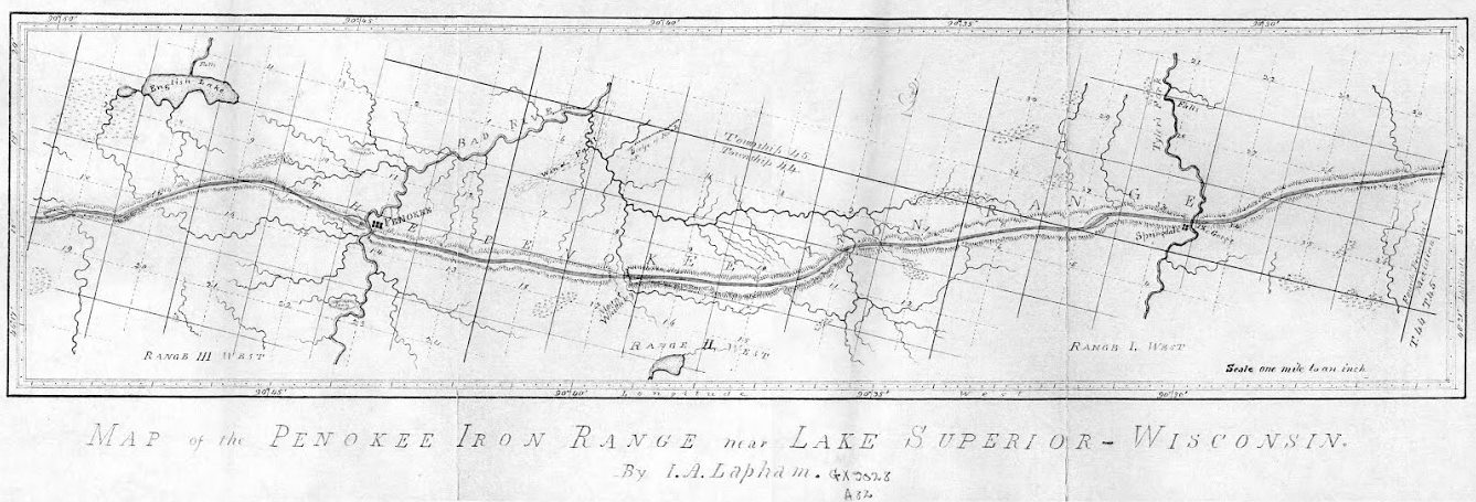
Increase A. Lapham surveyed the Penokee Iron Range on behalf of the Wisconsin & Lake Superior Mining and Smelting Company during 1858.
But what a change have these twenty years brought to the members, as well as the employees of the old company! Of the company, Palmer, Gen. Cutler, H. Hill, Sidebotham, Pixley, J.B.D. Cogswell, Small and Ripley have passed from earth. Lockwood and Harris are in New Orleans; J.F. Hill, J. Cummings and myself in Milwaukee, and Greves in California. Of the others I have no knowledge. Of the employees, Wheelock is upon a farm in Dakota; J.C. Cutler, at his home in Dexter, Maine; Whitcomb is in Milwaukee; Valliant, Stevens and Chase were killed in the late unpleasantness, and H.C. Palmer died in Milwaukee. Of the others I know not.
There are, however, many yet living with whom I became acquainted at that time, in Ashland and vicinity, for whom I have ever cherished the warmest personal friendship. If these sketches and reminiscences of long long ago have interested or amused them, I am glad. The writing of them has brought to mind many scenes and faces, that were almost forgotten, but which are as vivid now as though occurring yesterday. I hope, the coming season to see you all, and talk over old times, and make a trip to the Range over the old trail, every foot of which is accurately mapped in my eye. And now, as my task is done, at least for the present, I will bid the Press readers good-bye, and
Let Brother Whittlesey “spiel” it a while.
About that wonderful siege of Barlile.
J.S. Buck
Milwaukee, Dec. 18, 1877.
