Memoirs of Doodooshaboo: Joseph Austrian at Eagle River 1854-1859
November 2, 2024
By Amorin Mello
This post is the seventh of our Memoirs of Doodooshaboo series reproducing the memoirs of Joseph Austrian at the Chicago History Museum. The previous post began in 1852 when the Leopold & Austrian family transferred Joseph from their La Pointe store to work at their other store in Eagle River on the Keweenaw Peninsula, and ended up spending the Winter of 1853 at the family headquarters in Cleveland to greet his mother and siblings upon their arrival immigrating from Bavaria.
This post begins in 1854 upon Joseph’s return from Cleveland to Eagle River to continue the family business at their new storefront, and provides insights into the growing pains of the pioneering copper mining companies on the Keweenaw Peninsula, Joseph somehow fails to mention much else about life on Lake Superior during 1854-1859.
1854-1859 were the boom and bust years of La Pointe County land speculation, which arose from the La Pointe Treaty of 1854 and Soo Locks of 1855, and crashed with the 1857 Financial Panic of 1857 and American Civil War of 1861. It is unfortunate how Joseph’s memoirs do not mention anything about his Leopold & Austrian family’s business at La Pointe during 1854-1859, when they were capitalizing on Chippewa Treaty Allotments in the Penokee Mountains to form the La Pointe Iron Company.
Some of that story can be told through other records in our Austrian Papers and upcoming posts on Chequamegon History. Until then, we’ll continue with Joseph’s memoirs.
Memoirs of Doodooshaboo
… continued from after La Pointe 1852-54.
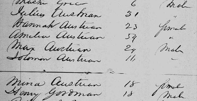
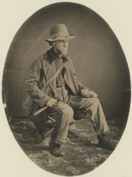
Partner of Leopolds in Eagle River Store. 1854.
Louis Leopold & Babette Austrian;
Hannah Leopold & Julius Austrian.
On our arrival in Eagle River, May 1854, I found the work on the store had not been properly finished by the contractor, and I had my hands full to get the new store in shape quickly for business without unnecessary delay. Henry Leopold & wife (my sister Ida) occupied the apartment over the store and I boarded with them as soon as they started housekeeping, which as a matter of course was a great improvement over our former mode of living, and fresh meat was no longer scarce.

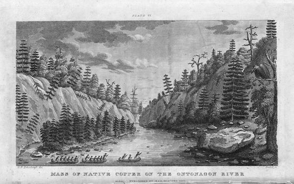
Sketch of the Cliff Mine, 1849.
~ The Cliff Mine Archeology Project Blog
The additional store now permitted us to add, various new departments in; grain, heavy provisions, hard ware, &c. We also opened up in connection with our business a meat market located at the Cliff Mine, managed by Henry F. Leopold with a branch at Eagle River. I took sole charge of the Eagle River business making the daily rounds to the Cliff and other near by mines, boarding houses and miners homes, soliciting orders. In the evenings I worked at the books, as I had no one to assist me in this work.
Sam went to Mackinaw to wind up the old business affairs of his brother Louis, then he went to New York and settled with his creditors. After this he went to Eagle River in the fall and we jointly attended to the business. He went to New York every season to buy goods, consisting of clothing, dry goods, boots & shoes & mens furnishing goods.
During the second winter of our settling at Eagle River, he went to Europe and became engaged to Babette Guttman, a cousin of mine, and the following winter he went to Europe again to be married and returned in the Spring with his wife. A Mr. Henry Guttman, Babette’s brother who had been interested with us in the meat market at the Cliff Mine assisted me in our store during Sam’s absence.
Henry Guttman (Goodman) immigrated with the Austrians.
~ 17 October 1853 passenger manifest of the steamer Atlantic.
Business Increases.
Later on I found it necessary to engage a book keeper owing to the rapid growth of our business, and for that purpose I engaged a Mr. Moses Hanauer, a son of the teacher in the native place of the Leopolds.
I made it my duty to solicit orders and deliver goods, and went the rounds in a delivery wagon daily, soliciting new orders. Of course I had a hostler to attend to the horses & wagons and who assisted in loading the goods. By the next year our store had again become too small and I contracted for a new wing to be added, which made a great improvement and gave us better facilities for carrying on our business.
Phoenix Mining Company’s Drafts Protested.
By an arrangement with the Phoenix Mining Co. we agreed to attend to the payment of their miners, taking the drafts of the Company’s agent in Boston in settlement each month. We did this on account of the business which came to us through it.

~ The Mining Magazine: Devoted to Mines, Mining Operations, Metallurgy, &c., &c., Volume 2, 1854, pg. 404.
After this thing had gone on for some time, the several drafts had amounted to a big sum, and unexpectedly to our consternation the drafts came back protested.
We had quite a struggle and wrangle trying to get them to make good their drafts. Finally Sam Leopold went to Boston and proposed that we would take the mine in payment of their debt if they though it was not worth the protested drafts. This proposition brought them to their senses and they made immediate arrangements then for funds by calling an assessment on the Stockholders to satisfy our claim.
The success we had met with in the Eagle River business in course of years gave us sufficient capital for new enterprises.
To be continued on the Keweenaw Range 1860-1864…
Colonel Charles Whittlesey
May 27, 2016
By Amorin Mello

C.C. Baldwin was a friend, colleague, and biographer of Charles Whittlesey.
~ Memorial of Charles Candee Baldwin, LL. D.: Late President of the Western Reserve Historical Society, 1896, page iii.
This is a reproduction of Colonel Charles Whittlesey’s biography from the Magazine of Western History, Volume V, pages 534-548, as published by his successor Charles Candee Baldwin from the Western Reserve Historical Society. This biography provides extensive and intimate details about the life and profession of Whittlesey not available in other accounts about this legendary man.
Whittlesey came to Lake Superior in 1845 while working for the Algonquin Mining Company along the Keweenaw Peninsula’s copper region. His first trip to Chequamegon Bay appears to have been in 1849 while doing do a geological survey of the Penokee Mountains for David Dale Owen. Whittlesey played a dramatic role in American settlement of the Chequamegon Bay region. Whittlesey convinced his brother, Asaph Whittlesey Jr., to move from the Western Reserve in 1854 establish what became the City of Ashland at the head of Chequamegon Bay as a future port town for extracting and shipping minerals from the Penokee Mountains. Whittlesey’s influence can still be witnessed to this day through local landmarks named in his honor:
Whittlesey published more than two hundred books, pamphlets, and articles. For additional research resources, the extensive Charles Whittlesey Papers are available through the Western Reserve Historical Society in two series:
Magazine of Western History, Volume V, pages 534-548.
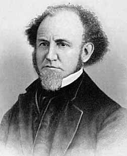
COLONEL CHARLES WHITTLESEY.

Map of the Connecticut Western Reserve in Ohio by William Sumner, September 1826.
~ Cleveland Public Library
![Asaph Whittlesey [Sr], Late of Tallmadge, Summit Co., Ohio by Vesta Hart Whittlesey and Susan Everett Whittlesey, né Fitch, 1872.](https://chequamegonhistory.com/wp-content/uploads/2016/05/asaph-whittlesey-vesta-hart.jpg)
[Father] Asaph Whittlesey [Sr], Late of Tallmadge, Summit Co., Ohio by [mother] Vesta Hart Whittlesey [posthumously] and [stepmother] Susan Everett Whittlesey, né Fitch, 1872.
~ Archive.org
War was then in the west, and his neighbors feared they might be the victims of the scalping knife. But the danger was different. In passing the Narrows, between Pittsburgh and Beaver, the wagon ran off a bank and turned completely over on the wife and children. They were rescued and revived, but the accident permanently impaired the health of Mr. Whittlesey.
Mr. Whittlesey was in Tallmadge, justice of the peace from soon after his arrival till near the close of his life, and postmaster from 1814, when the office was first established, to his death. He was again severely injured, but a strong constitution and unflinching will enabled him to accomplish much. He had a store, buying goods in Pittsburgh and bringing them in wagons to Tallmadge; and an ashery; and in 1818 he commenced the manufacture of iron on the Little Cuyahoga, below Middlebury.
The times were hard, tariff reduced, and in 1828 he returned to his farm prematurely old. He died in 1842. Says General Bierce,
“His intellect was naturally of a high order, his religious convictions were strong and never yielded to policy or expediency. He was plain in speech, sometimes abrupt. Those who respected him were more numerous than those who loved him. But for his friends, no one had a stronger attachment. His dislikes were not very well concealed or easily removed. In short, he was a man of strong mind, strong feelings, strong prejudices, strong affections and strong attachments, yet the whole was tempered with a strong sense of justice and strong religious feelings.”
[Uncle] Elisha Whittlesey
~ Collection of the U.S. House of Representatives

Portrait of Reverend David Bacon from ConnecticutHistory.org:
“David Bacon (1771 – August 27, 1817) was an American missionary in Michigan Territory. He was born in Woodstock, Connecticut. He worked primarily with the Ottawa and Chippewa tribes, although they were not particularly receptive to his Christian teachings. He founded the town of Tallmadge, Ohio, which later became the center of the Congregationalist faith in Ohio.”
~ Wikipedia.org
Tallmadge was settled in 1808 as a religious colony of New England Congregationalists, by a colony led by Rev. David Bacon, a missionary to the Indians. This affected the society in which the boy lived, and exercised much influence on the morality of the town and the future of its children, one of whom was the Rev. Leonard Bacon. Rev. Timlow’s History of Southington says, “Mr. Whittlesey moved to Tallmadge, having become interested in settling a portion of Portage county with Christian families.” And that he was a man “of surpassing excellence of character.”
If it should seem that I have dwelt upon the parents of Colonel Whittlesey, it is because his own character and career were strongly affected by their characters and history. Charles, the son, combined the traits of the two. He commenced school at four years old in Southington; the next year he attended the log school house at Tallmadge until 1819, when the frame academy was finished and he attended it in winter, working on the farm in summer until he was nineteen.
The boy, too, saw early life on foot, horseback and with ox-teams. He found the Indians still on the Reserve, and in person witnessed the change from savage life and new settlements, to a state of three millions of people, and a large city around him. One of Colonel Whittlesey’s happiest speeches is a sketch of log cabin times in Tallmadge, delivered at the semi-centennial there in 1857.
~ Annual Report on the Geological Survey of the State of Ohio: 1837 by Ohio Geologist William Williams Mather, 1838, page 22.
In 1827 the youngster became a cadet at West Point. Here he displayed industry, and in some unusual incidents there, coolness and courage. He graduated in 1831, and became brevet second lieutenant in the Fifth United States infantry, and in November started to join his regiment at Mackinaw. He did duty through the winter with the garrison at Fort Gratiot. In the spring he was assigned at Green Bay to the company of Captain Martin Scott, so famous as a shot. At the close of the Black Hawk War he resigned from the army. Though recognizing the claim of the country to the services of the graduates of West Point, he tendered his services to the government during the Seminole Mexican war. By a varied experience his life thereafter was given to wide and general uses. He at first opened a law office in Cleveland, Ohio, and was fully occupied in his profession, and as part owner and co-editor of the Whig and Herald until the year 1837. He was that year appointed assistant geologist of the state of Ohio. Through very uneconomical economy, the survey was discontinued at the end of two years, when the work was partly done and no final reports had been made. Of course most of the work and its results were lost. Great and permanent good indeed resulted to the material wealth of the state, in disclosing the rich coal and iron deposit of southeastern Ohio, thus laying the foundation for the vast manufacturing industries which have made that portion of the state populous and prosperous. The other gentlemen associated with him were Professor William Mather as principal; Dr. Kirtland was entrusted with natural history. Others were Dr. S. P. Hildreth, Dr. Caleb Briggs, Jr., Professor John Locke and Dr. J. W. Foster. It was an able corps, and the final results would have been very valuable and accurate. In 1884, Colonel Whittlesey was sole survivor and said in this Magazine:
“Fifty years since, geology had barely obtained a standing among the sciences even in Europe. In Ohio it was scarcely recognized. The state at that time was more of a wilderness than a cultivated country, and the survey was in progress little more than two years. It was unexpectedly brought to a close without a final report. No provision was made for the preservation of papers, field notes and maps.”
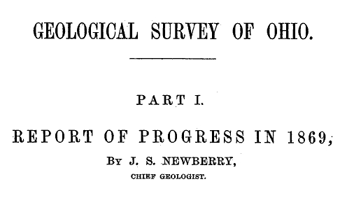
Report of Progress in 1869, by J. S. Newberry, Chief Geologist, by the Geological Survey of Ohio, 1870.
Professor Newbury, in a brief resume of the work of the first survey (report of 1869), says the benefits derived “conclusively demonstrate that the geological survey was a producer and not a consumer, that it added far more than it took from the public treasury and deserved special encouragement and support as a wealth producing agency in our darkest financial hour.” The publication of the first board, “did much,” says Professor Newberry, “to arrest useless expenditure of money in the search for coal outside of the coal fields and in other mining enterprises equally fallacious, by which, through ignorance of the teachings of geology, parties were constantly led to squander their means.” “It is scarcely less important to let our people know what we have not, than what we have, among our mineral resources.”

“Descriptions of Ancient Works in Ohio. By Charles Whittlesey, of the late Geological Corps of Ohio.”
~ Smithsonian Contributions to Knowledge, Volume III., Article 7, 1852.
The topographical and mathematical parts of the survey were committed to Colonel Whittlesey. He made partial reports, to be found in the ‘State Documents’ of 1838 and 1839, but his knowledge acquired in the survey was of vastly greater service in many subsequent writings, and, as a foundation for learning, made useful in many business enterprises of Ohio. He had, during this survey, examined and surveyed many ancient works in the state, and, at its close, Mr. Joseph Sullivant, a wealthy gentleman interested in archaeology, residing in Columbus, proposed that, he bearing the actual expense, Whittlesey should continue the survey of the works of the Mound Builders, with a view to joint publication. During the years 1839 and 1840, and under the arrangement, he made examination of nearly all the remaining works then discovered, but nothing was done toward their publication. Many of his plans and notes were used by Messrs. Squier & Davis, in 1845 and 1846, in their great work, which was the first volume of the Smithsonian Contributions, and in that work these gentlemen said:
“Among the most zealous investigators in the field of American antiquarian research is Charles Whittlesey, esq., of Cleveland, formerly topographical engineer of Ohio. His surveys and observations, carried on for many years and over a wide field, have been both numerous and accurate, and are among the most valuable in all respects of any hitherto made. Although Mr. Whittlesey, in conjunction with Joseph Sullivant, esq., of Columbus, originally contemplated a joint work, in which the results of his investigations should be embodied, he has, nevertheless, with a liberality which will be not less appreciated by the public than by the authors, contributed to this memoir about twenty plans of ancient works, which, with the accompanying explanations and general observations, will be found embodied in the following pages.
“It is to be hoped the public may be put in possession of the entire results of Mr. Whittlesey’s labor, which could not fail of adding greatly to our stock of knowledge on this interesting subject.”

“Marietta Works, Ohio. Charles Whittlesey, Surveyor 1837.”
~ Smithsonian Contributions to Knowledge, Volume I., Plate XXVI.
It will be seen that Mr. Whittlesey was now fairly started, interested and intelligent, in the several fields which he was to make his own. And his very numerous writings may be fairly divided into geology, archaeology, history, religion, with an occasional study of topographical geology. A part of Colonel Whittlesey’s surveys were published in 1850, as one of the Smithsonian contributions; portions of the plans and minutes were unfortunately lost. Fortunately the finest and largest works surveyed by him were published. Among those in the work of Squier & Davis, were the wonderful extensive works at Newark, and those at Marietta. No one again could see those works extending over areas of twelve and fifteen miles, as he did. Farmers cannot raise crops without plows, and the geography of the works at Newark must still be learned from the work of Colonel Whittlesey.
~ Smithsonian Contributions to Knowledge, Volume XIII., Article IV., page 2 of “Ancient Mining on the Shores of Lake Superior” by Charles Whittlesey.
He made an agricultural survey of Hamilton county in 1844. That year the copper mines of Michigan began to excite enthusiasm. The next year a company was organized in Detroit, of which Colonel Whittlesey was the geologist. In August they launched their boat above the rapids of the Sault St. Marie and coasted along the shore to where is now Marquette. Iron ore was beneath notice, and in truth was no then transportable, and they pulled away for Copper Harbor, and then to the region between Portage lake and Ontonagon, where the Algonquin and Douglas Houghton mines were opened. The party narrowly escaped drowning the night they landed. Dr. Houghton was drowned the same night not far from them. A very interesting and life-like account of their adventures was published by Colonel Whittlesey in the National Magazine of New York City, entitled “Two Months in the Copper Regions.” From 1847 to 1851 inclusive, he was employed by the United States in the survey of the country around Lake Superior and the upper Mississippi, in reference to mines and minerals. After that he spent much time in exploring and surveying the mineral district of the Lake Superior basin. The wild life of the woods with a guide and voyageurs threading the streams had great attractions for him and he spent in all fifteen seasons upon Lake Superior and the upper Mississippi, becoming thoroughly familiar with the topography and geological character of that part of the country.

“Pictograph C. Okundekund [Okandikan] and his Band of Ontonagon – Michigan,” as reproduced from birch bark by Seth Eastman, and published as Plate 62 in Historical and Statistical Information Respecting the History, Condition, and Prospects of the Indian Tribes of the United States, Volume I., by Henry Rowe Schoolcraft, 1851. This was one of several pictograph petitions from the 1849 Martell delegation:
“By this scroll, the chief Kun-de-kund of the Eagle totem of the river Ontonagon, of Lake Superior, and certain individuals of his band, are represented as uniting in the object of their visit of Oshcabewis. He is depicted by the figure of an eagle, Number 1. The two small lines ascending from the head of the bird denote authority or power generally. The human arm extended from the breast of the bird, with the open hand, are symbolic of friendship. By the light lines connecting the eye of each person with the chief, and that of the chief with the President, (Number 8,) unity of views or purpose, the same as in pictography Number 1, is symbolized. Number 2, 3, 4, and 5, are warriors of his own totem and kindred. Their names, in their order, are On-gwai-sug, Was-sa-ge-zhig, or The Sky that lightens, Kwe-we-ziash-ish, or the Bad-boy, and Gitch-ee-man-tau-gum-ee, or the great sounding water. Number 6. Na-boab-ains, or Little Soup, is a warrior of his band of the Catfish totem. Figure Number 7, repeated, represents dwelling-houses, and this device is employed to deonte that the persons, beneath whose symbolic totem it is respectively drawn, are inclined to live in houses and become civilized, in other words, to abandon the chase. Number 8 depicts the President of the United States standing in his official residence at Washington. The open hand extended is employed as a symbol of friendship, corresponding exactly, in this respect, with the same feature in Number 1. The chief whose name is withheld at the left hand of the inferior figures of the scroll, is represented by the rays on his head, (Figure 9,) as, apparently, possessing a higher power than Number 1, but is still concurring, by the eye-line, with Kundekund in the purport of pictograph Number 1.”
“Studio portrait of geologist Charles Whittlesey dressed for a field trip.” Circa 1858.
~ Wisconsin Historical Society
His detailed examination extended along the copper range from the extreme east of Point Keweenaw to Ontonagon, through the Porcupine mountain to the Montreal river, and thence to Long lake in Wisconsin, a distance of two hundred miles. In 1849, 1850 and 1858 he explored the valley of the Menominee river from its mouth to the Brule. He was the first geologist to explore the South range. The Wisconsin Geological Survey (Vol. 3 pp. 490 and 679) says this range was first observed by him, and that he many years ago drew attention to its promise of merchantable ores which are now extensively developed from the Wauceda to the Commonwealth mines, and for several miles beyond. He examined the north shore from Fond du Lac east, one hundred miles, the copper range of Minnesota and on the St. Louis river to the bounds of our country. His report was published by the state in 1865, and was stated by Professor Winchill to be the most valuable made.
All his geological work was thorough, and the development of the mineral resources which he examined, and upon which he reported, gave the best proofs of his scientific ability and judgment.

“Outline Map Showing the Position of the Ancient Mine Pits of Point Keweenaw, Michigan by Charles Whittlesey.”
~ Smithsonian Contributions to Knowledge, Volume XIII., Article IV., frontpiece of “Ancient Mining on the Shores of Lake Superior” by Charles Whittlesey, 1863.
With the important results from his labors in Ohio in mind, the state of Wisconsin secured his services upon the geological survey of that state, carried on in 1858, 1859 and 1860, and terminated only by the war. The Wisconsin survey was resumed by other parties, and the third volume of the Report for Northern Wisconsin, page 58, says:
The Contract of James Hall with Charles Whittlesey is available from the Journal of the Assembly of Wisconsin, Volume I, pages 178-179, 1862. Whittlesey was to perform “a careful geological survey of the country lying between the Montreal river on the east, and the westerly branches of [the] Bad River on west”. This contract was unfulfilled due to the outbreak of the American Civil War. Whittlesey independently published his survey of the Penokee Mountains in 1865 without Hall. Some of Whittlesey”s pamphlets have been republished here on Chequamegon History in the Western Reserve category of posts.“The only geological examinations of this region, however, previous to those on which the report is based, and deserving the name, were those of Colonel Charles Whittlesey of Cleveland, Ohio. This gentleman was connected with Dr. D. D. Owen’s United States geological survey of Wisconsin, Iowa and Minnesota, and in this connection examined the Bad River country, in 1848. The results are given in Dr. Owen’s final report, published in Washington, in 1852. In 1860 (August to October) Colonel Whittlesey engaged in another geological exploration in Ashland, Bayfield and Douglass counties, as part of the geological survey of Wisconsin, then organized under James Hall. His report, presented to Professor Hall in the ensuing year, was never published, on account of the stoppage of the survey. A suite of specimens, collected by Colonel Whittlesey during these explorations, is at present preserved in the cabinet of the state university at Madison, and it bears testimony to the laborious manner in which that gentleman prosecuted the work. Although the report was never published, he has issued a number of pamphlet publications, giving the main results obtained by him. A list of them, with full extracts from some of them, will be found in an appendix to the report. In the same appendix I have reproduced a geological map of this region, prepared by Colonel Whittlesey in 1860.”

“Geological Map of the Penokie Range.” by Charles Whittlesey, Dec. 1860.
~ Geology of Wisconsin. Survey of 1873-1879. Volume III., 1880, Plate XX, page 214.
~ Biographical Register of the Officers and Graduates of the United States Military Academy at West Point, New York, since its establishment in 1802 by George W. Cullum, page 496.
“The Baltimore Plot was an alleged conspiracy in late February 1861 to assassinate President-elect Abraham Lincoln en route to his inauguration. Allan Pinkerton, founder of the Pinkerton National Detective Agency, played a key role by managing Lincoln’s security throughout the journey. Though scholars debate whether or not the threat was real, clearly Lincoln and his advisors believed that there was a threat and took actions to ensure his safe passage through Baltimore, Maryland.”
~ Wikipedia.org
Such was Colonel Whittlesey’s employment when the first signs of the civil war appeared. He abandoned it at once. He became a member of one of the military companies that tendered its services to President-elect Lincoln, when he was first threatened, in February, 1861. He became quickly convinced that war was inevitable, and urged the state authorities that Ohio be put at once in preparation for it; and it was partly through his influence that Ohio was so very ready for the fray, in which, at first, the general government relied on the states. Two days after the proclamation of April 15, 1861, he joined the governor’s staff as assistant quartermaster-general. He served in the field in West Virginia with the three months’ men, as state military engineer; with the Ohio troops, under General McClellan, Cox and Hill. At Seary Run, on the Kanawha, July 17, 1861, he distinguished himself by intrepidity and coolness during a severe engagement, in which his horse was shot under him. At the expiration of the three months’ service, he was appointed colonel of the Twentieth regiment, Ohio volunteers, and detailed by General Mitchell as chief engineer of the department of Ohio, where he planned and constructed the defenses of Cincinnati.

“[Brother] Asaph Whittlesey [Jr.] dressed for his journey from Ashland to Madison, Wisconsin, to take up his seat in the state legislature. Whittlesey is attired for the long trek in winter gear including goggles, a walking staff, and snowshoes.” Circa 1860.
~ Wisconsin Historical Society
“SIR: Will you allow me to suggest the consideration of a great movement by land and water, up the Cumberland and Tennessee rivers.
“First, Would it not allow of water transportation half way to Nashville?
“Second, Would it not necessitate the evacuation of Columbus, by threatening their railway communications?
“Third, Would it not necessitate the retreat of General Buckner, by threatening his railway lines?
“Fourth, Is it not the most feasible route into Tennessee?”
This plan was adopted, and Colonel Whittlesey’s regiment took part in its execution.
In April, 1862, on the second day of the battle of Shiloh, Colonel Whittlesey commanded the Third brigade of General Wallace’s division — the Twentieth, Fifty-sixth, Seventy-sixth and Seventy-eighth Ohio regiments. “It was against the line of that brigade that General Beauregard attempted to throw the whole weight of his force for a last desperate charge; but he was driven back by the terrible fire, that his men were unable to face.” As to his conduct, Senator Sherman said in the United States senate.1
The official report of General Wallace leaves little to be said. The division commander says, “The firing was grand and terrible. Before us was the Crescent regiment of New Orleans; shelling us on our right was the Washington artillery of Manassas renown, whose last charge was made in front of Colonel Whittlesey’s command.”
“This is an engraved portrait of Charles Whittlesey, a prominent soldier, attorney, scholar, newspaper editor, and geologist during the nineteenth century. He participated in a geological survey of Ohio conducted in the late 1830s, during which he discovered numerous Native American earthworks. In 1867, Whittlesey helped establish the Western Reserve Historical Society, and he served as the organization’s president until his death in 1886. Whittlesey also wrote approximately two hundred books and articles, mostly on geology and Ohio’s early history.”
~ Ohio History Central
General Force, then lieutenant-colonel under Colonel Whittlesey, fully describes the battle,2 and quotes General Wallace. “The nation is indebted to our brigade for the important services rendered, with the small loss it sustained and the manner in which Colonel Whittlesey handled it.”
Colonel Whittlesey was fortunate in escaping with his life, for General Force says, it was ascertained that the rebels had been deliberately firing at him, sometimes waiting to get a line shot.
Colonel Whittlesey had for some time been in bad health, and contemplating resignation, but deferring it for a decisive battle. Regarding this battle as virtually closing the campaign in the southwest, and believing the Rebellion to be near its end, he now sent it in.
General Grant endorsed his application, “We cannot afford to lose so good an officer.”
“Few officers,” it is said, “retired from the army with a cleaner or more satisfactory record, or with greater regret on the part of their associates.” The Twentieth was an early volunteer regiment. The men were citizens of intelligence and character. They reached high discipline without severity, and without that ill-feeling that often existed between men and their officers. There was no emergency in which they could not be relied upon. “Between them and their commander existed a strong mutual regard, which, on their part, was happily expressed by a letter signed by all the non-commissioned officers.”
“CAMP SHILOH, NEAR PITTSBURGH LANDING, TENNESSEE, April 21, 1862.
“COL. CHAS. WHITTLESEY:
“Sir — We deeply regret that you have resigned the command of the Twentieth Ohio. The considerate care evinced for the soldiers in camp, and, above all, the courage, coolness and prudence displayed on the battle-field, have inspired officers and men with the highest esteem for, and most unbounded confidence in our commander.
“From what we have seen at Fort Donelson, and at the bloody field near Pittsburgh, on Monday, the seventh, all felt ready to follow you unfalteringly into any contest and into any post of danger.
“While giving expression to our unfeigned sorrow at your departure from us, and assurance of our high regard and esteem for you, and unwavering confidence as our leader, we would follow you with the earnest hope that your future days may be spent in uninterrupted peace and quiet, enjoying the happy reflections and richly earned rewards of well-spent service in the cause of our blessed country in its dark hour of need.”
Said Mr. W. H. Searles, who served under him, at the memorial meeting of the Engineers Club of Cleveland: “In the war he was genial and charitable, but had that conscientious devotion to duty characteristic of a West Point soldier.”
Since Colonel Whittlesey’s decease the following letter was received:
“CINCINNATI, November 10, 1886.
“DEAR MRS. WHITTLESEY: — Your noble husband has got release from the pains and ills that made life a burden. His active life was a lesson to us how to live. His latter years showed us how to endure. To all of us in the Twentieth Ohio regiment he seemed a father. I do not know any other colonel that was so revered by his regiment. Since the war he has constantly surprised me with his incessant literary and scientific activity. Always his character was an example and an incitement. Very truly yours,
“M. F. Force.”
Colonel Whittlesey now turned his attention at once again to explorations in the Lake Superior and upper Mississippi basins, and “new additions to the mineral wealth of the country were the result of his surveys and researches.” His geological papers commencing again in 1863, show his industry and ability.
It happened during his life many times, and will happen again and again, that his labors as an original investigator have borne and will bear fruit long afterwards, and, as the world looks at fruition, of much greater value to others than to himself.
~ Report of a geological survey of Wisconsin, Iowa, and Minnesota: and incidentally of a portion of Nebraska Territory, by David Dale Owen, 1852, page 420.
He prognosticated as early as 1848, while on Dr. Owen’s survey, that the vast prairies of the northwest would in time be the great wheat region. These views were set forth in a letter requested by Captain Mullen of the Topographical Engineers, who had made a survey for the Northern Pacific railroad, and was read by him in a lecture before the New York Geographical society in the winter of 1863-4.
He examined the prairies between the head of the St. Louis river and Rainy Lake, between the Grand fork of Rainy Lake river and the Mississippi, and between the waters of Cass Lake and those of Red Lake. All were found so level that canals might be made across the summits more easily than several summits already cut in this country.
In 1879 the project attracted attention, and Mr. Seymour, the chief engineer and surveyor of New York, became zealous for it, and in his letters of 1880, to the Chambers of Commerce of Duluth and Buffalo, acknowledged the value of the information supplied by Colonel Whittlesey.
Says the Detroit Illustrated News:
“A large part of the distance from the navigable waters of Lake Superior to those of Red river, about three hundred and eight miles, is river channel easily utilized by levels and drains or navigable lakes. The lift is about one thousand feet to the Cass Lake summit. At Red river this canal will connect with the Manitoba system of navigation through Lake Winnipeg and the valleys of the Saskatchewan. Its probable cost is given at less than four millions of dollars, which is below the cost of a railway making the same connections. And it is estimated that a bushel of wheat may be carried from Red river to New York by water for seventeen cents, or about one-third of the cost of transportation by rail.”
We approach that part of the life of Colonel Whittlesey which was so valuable to our society. The society was proposed in 1866.3 Colonel Whittlesey’s own account of its foundation is: “The society originally comprised about twenty persons, organized in May, 1867, upon the suggestion of C. C. Baldwin, its present secretary. The real work fell upon Colonel Whittlesey, Mr. Goodman and Mr. Baldwin, Mr. Goodman devoting nearly all of his time until 1872 (the date of his death).” The statement is a very modest one on the part of Colonel Whittlesey. All looked to him to lead the movement, and none other could have approached his efficiency or ability as president of the society.
The society seemed as much to him as a child is to a parent, and his affection for it has been as great. By his learning, constant devotion without compensation from that time to his death, his value as inspiring confidence in the public, his wide acquaintance through the state, he has accomplished a wonderful result, and this society and its collections may well be regarded as his monument.
Mr. J. P. Holloway, in his memorial notice before the Civil Engineer’s club, of which Colonel Whittlesey was an honorary member, feelingly and justly said:
“Colonel Whittlesey will be best and longest remembered in Cleveland and on the Reserve, for his untiring interest and labors in seeking to rescue from oblivion the pioneer history of this portion of the state, and which culminated in the establishment of the present Western Reserve Historical society, of which for many years he was the presiding officer. It will be remembered by many here, how for years there was little else of the Western Reserve Historical society, except its active, hard working president. But as time moved on, and one by one the pioneers were passing away, there began to be felt an increasing interest in preserving not only the relics of a by-gone generation, but also the records of their trials and struggles, until now we can point with a feeling of pride to the collections of a society which owes its existence and success to a master spirit so recently called away.”
The colonel was remarkably successful in collecting the library, in which he interested with excellent pecuniary purpose the late Mr. Case. He commenced the collection of a permanent fund which is now over ten thousand dollars. It had reached that amount when its increase was at once stopped by the panic of 1873, and while it was growing most rapidly. The permanent rooms, the large and very valuable museum, are all due in greatest measure to the colonel’s intelligent influence and devotion.
I well remember the interest with which he received the plan; the instant devotion to it, the zeal with which at once and before the society was started, he began the preparation of his valuable book, The Early History of Cleveland, published during the year.
Colonel Whittlesey was author of — I had almost said most, and I may with no dissent say— the most valuable publications of the society. His own very wide reputation as an archaeologist and historian also redounded to its credit. But his most valuable work was not the most showy, and consisted in the constant and indefatigable zeal he had from 1867 to 1886, in its prosperity. These were twenty years when the welfare of the society was at all times his business and never off his mind. During the last few years Colonel Whittlesey has been confined to his home by rheumatism and other disorders, the seeds of which were contracted years before in his exposed life on Lake Superior, and he has not been at the rooms for years. He proposed some years since to resign, but the whole society would have felt that the fitness of things was over had the resignation been accepted. Many citizens of Cleveland recall that if Colonel Whittlesey could no longer travel about the city he could write. And it was fortunate that he could. He took great pleasure in reading and writing, and spent much of his time in his work, which continued when he was in a condition in which most men would have surrendered to suffering.
Colonel Whittlesey did not yet regard his labors as finished. During the last few years of his life religion, and the attitude and relation of science to it, engaged much of his thought, and he not unfrequently contributed an editorial or other article to some newspaper on the subject. Lately these had taken more systematic shape, and as late as the latter part of September, and within thirty days of his death, he closed a series of articles which were published in the Evangelical Messenger on “Theism and Atheism in Science.” These able articles were more systematic and complete than his previous writings on the subject, and we learn from the Messenger that they will be published in book form. The paper says:
Colonel Charles Whittlesey of this city, known to our readers as the author of an able series of articles on “Theism and Atheism in Science” just concluded, has fallen asleep in Jesus. One who knew the venerable man and loved him for his genuine worth said to us that “his last work on earth was the preparation of these articles . . . which to him was a labor of love and done for Christ’s sake.”
!["The Old Whittlesey Homestead, Euclid Avenue [Cleveland, Ohio]." ~ Historical Collections of Ohio in Two Volumes, by Henry Howe, 1907, page 521.](https://chequamegonhistory.com/wp-content/uploads/2016/05/whittlesey-home-cleveland.jpg)
“The Old Whittlesey Homestead, Euclid Avenue.” [Cleveland, Ohio]
~ Historical Collections of Ohio in Two Volumes by Henry Howe, 1907, page 521.
Colonel Whittlesey was married October 4, 1858, to Mrs. Mary E. (Lyon) Morgan4 of Oswego, New York, who survives him; they had no children.
!["Char. Whittlesey - Cleveland Ohio, Oct. 30, 1895[?] - Geologist of Ohio." ~ Wisconsin Historical Society](https://chequamegonhistory.com/wp-content/uploads/2016/05/charles-whittlesey-geologist.jpg)
Charles Whittlesey died on October 18th, 1886, and was never Ohio’s State Geologist.
“Char. Whittlesey – Cleveland Ohio, Oct. 30, 1895[?] – Geologist of Ohio.”
~ Wisconsin Historical Society
Much of his work does not therefore appear in that complete and systematic shape which would make it best known to the general public. But by scholars in his lines of study in Europe and America, he was well known and very highly respected. “His contributions to literature,” said the New York Herald,5 “have attracted wide attention among the scientific men of Europe and America.”
Whittlesey Culture:
A.D. 1000 to 1600
“‘Whittlesey Culture’ is an archaeological designation referring to a Late Prehistoric (more appropriately: Late Pre-Contact) North American indigenous group that occupied portions of northeastern Ohio. This culture isdistinguished from other so-called Late Prehistoric societies mainly by distinctive kinds of pottery. Many Whittlesey communities were located on plateaus overlooking stream valleys or the shores of Lake Erie. The villages often were surrounded with a pallisade or a ditch, suggesting a need for defense.
“The Whittlesey culture is named for Charles Whittlesey, a 19th century geologist and archaeologist who was a founder of the Western Reserve Historical Society.”
As an American archaeologist, Colonel Whittlesey was very learned and thorough. He had in Ohio the advantage of surveying its wonderful works at an early date. He had, too, that cool poise and self-possession that prevented his enthusiasm from coloring his judgment. He completely avoided errors into which a large share of archaeologists fall. The scanty information as to the past and its romantic interest, lead to easy but dangerous theories, and even suffers the practice of many impositions. He was of late years of great service in exposing frauds, and thereby helped the science to a healthy tone. It may be well enough to say that in one of his tracts he exposed, on what was apparently the best evidence, the supposed falsity of the Cincinnati tablet so called. Its authenticity was defended by Mr. Robert Clarke of Cincinnati, successfully and convincingly, to Colonel Whittlesey himself. I was with the colonel when he first heard of the successful defense and with a mutual friend who thought he might be chagrined, but he was so much more interested in the truth for its own sake, than in his relations to it, that he appeared much pleased with the result.
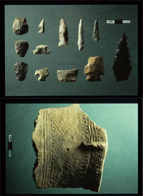
Whittlesey Culture artifacts: “South Park Village points (above) and pottery fragment (below)”
~ Cuyahoga Valley National Park
Among American writers, Mr. Short speaks of his investigations as of “greater value, due to the eminence of the antiquarian who writes them.” Hon. John D. Baldwin says, “in this Ancient America speaks of Colonel Whittlesey as one of the best authorities.” The learned Frenchman, Marquis de Nadaillac and writers generally upon such subjects quote his information and conclusions with that high and safe confidence in his learning and sound views which is the best tribute to Colonel Whittlesey, and at the same time a great help to the authors. And no one could write with any fullness on the archaeology of America without using liberally the work of Colonel Whittlesey, as will appear in any book on the subject. He was an extensive, original investigator, always observing, thoughtful and safe, and in some branches, as in Ancient Mining at Lake Superior, his work has been the substantial basis of present learning. It is noticeable that the most eminent gentlemen have best appreciated his safe and varied learning. Colonel Whittlesey was early in the geological field. Fifty years ago little was known of paleontology, and Colonel Whittlesey cared little for it, perhaps too little; but in economic geology, in his knowledge of Ohio, its surface, its strata, its iron, its coal and its limestone in his knowledge of the copper and iron of the northwest, he excelled indeed. From that date to his death he studied intelligently these sections. As Professor Lapham said he was studying Wisconsin, so did Colonel Whittlesey give himself to Ohio, its mines and its miners, its manufactures, dealings in coal and iron, its history, archaeology, its religion and its morals. Nearly all his articles contributed to magazines were to western magazines, and anyone who undertook a literary enterprise in the state of Ohio that promised value was sure to have his aid.6
In geology his services were great. The New York Herald, already cited, speaks of his help toward opening coal mines in Ohio and adds,“he was largely instrumental in discovering and causing the development of the great iron and copper regions of Lake Superior.” Twenty-six years ago he discovered a now famous range of iron ore.
“ On the Mound Builders and on the geological character and phenomena of the region of the lakes and the northwest he was quoted extensively as an authority in most of the standard geological and anthropological works of America and Europe,” truthfully says the ‘Biographical Cyclopedia.
Colonel Whittlesey was as zealous in helping to preserve new and original material for history as for science. In 1869 he pushed with energy the investigation, examination and measures which resulted in the purchase by the State of Ohio of the St. Clair papers so admirably, fully and ably edited by Mr. William Henry Smith, and in 1882 published in two large and handsome volumes by Messrs. Robert Clarke and Co. of Cincinnati.
Colonel Whittlesey was very prominent in the project which ended in the publication of the Margry papers in Paris. Their value may be gathered from the writing of Mr. Parkman (La Salle) and The Narrative and Critical History of America, Volume IV., where on page 242 is an account of their publication.7 In 1870 and 1871 an effort to enlist congress failed. The Boston fire defeated the efforts of Mr. Parkman to have them published in that city. Colonel Whittlesey originated the plan eventually adopted, by which congress voted ten thousand dollars as a subscription for five hundred copies, and, as says our history: “at last by Mr. Parkman’s assiduous labors in the east, and by those of Colonel Whittlesey, Mr. O. H. Marshall and others in the west,” the bill was passed.
The late President Garfield, an active member of our society, took a lively interest in the matter, and instigated by Colonel Whittlesey used his strong influence in its favor. Mr. Margry has felt and expressed a very warm feeling for Colonel Whittlesey for his interest and efforts, and since the colonel’s death, and in ignorance of it, has written him a characteristic letter to announce to the colonel, first of any in America, the completion of the work. A copy of the letter follows :
“PARIS, November 4, 1886.
“VERY DEAR AND HONORED SIR: It is to-day in France, St. Charles’ day, the holiday I wished when I had friends so called. I thought it suitable to send you to-day the good news to continue celebrating as of old. You will now be the first in America to whom I write it. I have just given the check to be drawn, for the last leaves of the work, of which your portrait may show a volume under your arm.8 Therefore there is no more but stitching to be done to send the book on its way.
“In telling you this I will not forget to tell you that I well remembered the part you took in that, publication as new, as glorious for the origin of your state, and for which you can congratulate yourself, in thanking you I have but one regret, that Mr. Marshall can not have the same pleasure. I hope that your health as well as that of Madame Whittlesey is satisfactory. I would be happy to hear so. For me if I am in good health it is only by the intervention of providence. However, I have lost much strength, though I do not show it. We must try to seem well.
“Receive, dear and honored sir, and for Madame, the assurance of my profound respect and attachment.
“PIERRE MARGRY.”
Colonel Whittlesey views of the lives of others were affected by his own. Devoted to extending human learning, with little thought of self interest, he was perhaps a little too impatient with others, whose lives had other ends deemed by them more practical. Yet after all, the colonel’s life was a real one, and his pursuits the best as being nearer to nature and far removed from the adventitious circumstances of what is ordinarily called polite life.
He impressed his associates as being full of learning, not from books, but nevertheless of all around — the roads the fields, the waters, the sky, men animals or plants. Charming it was to be with him in excursions; that was really life and elevated the mind and heart.
He was a profoundly religious man, never ostentatiously so, but to him religion and science were twin and inseparable companions. They were in his life and thought, and he wished to and did live to express in print his sense that the God of science was the God of religion, and that the Maker had not lost power over the thing made.
He rounded and finished his character as he finished his life, by joint and hearty affection and service to the two joint instruments of God’s revelation, for so he regarded them. Rev. Dr. Hayden testifies: “He had no patience with materialism, but in his mature strength of mind had harmonized the facts of science with the truths of religion.”

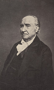
Charles Whittlesey
~ Magazine of Western History, Volume V, page 536.
Colonel Whittlesey’s life was plain, regular and simple. During the last few years he suffered much from catarrhal headache, rheumatism and kindred other troubles, and it was difficult for him to get around even with crutches. This was attributed to the exposure he had suffered for the fifteen years he had been exposed in the Lake Superior region, and his long life and preservation of a clear mind was no doubt due to his simple habits. With considerable bodily suffering, his mind was on the alert, and he seemed to have after all considerable happiness, and, to quote Dr Hayden, he could say with Byrd, “thy mind to me a kingdom is.”
Colonel Whittlesey was an original member of the American Association for the Advancement of Science, an old and valued member of the American Antiquarian society, an honorary member of the Ohio State Archaeological and Historical society, with headquarters at Columbus. He was trustee of the former State Archaeological society (making the archaeological exhibition at the Centennial), and although each of these is necessarily to some extent a rival of his pet society, he took a warm interest in the welfare of each.
He was a member of the Society of Americanites of France, and his judgment, learning and communications were much esteemed by the French members of that society. Of how many other societies he was an honorary or other member I can not tell.
C. C. Baldwin.
1 – Speech of May 9, 1862.
2 – Cincinnati Commercial, April 9, 1862.
3 – The society was organized under the auspices of the Cleveland Library Association (now Case Library). The plan occurred to the writer while vice-president of that association. At the annual meeting in 1867, the necessary changes were made in the constitution, and Colonel Whittlesey was elected to the Case Library board for the purpose of heading the historical committee and movement. The result appears in a scarce pamphlet issued in 1867 by the library association, containing, among other things, an account of the formation of the society and an address by Colonel Whittlesey, which is an interesting sketch of the successive literary and library societies of Cleveland, of which the first was in 1811.
4 – Mary E. Lyon was a daughter of James Lyon of Oswego, and sister of John E. Lyon, now of Oswego but years ago a prominent citizen of Cleveland. She m. first Colonel Theophilus Morgan,6 Theophilus,5 Theophilus,4 Theophilus,3 John,2 James Morgan.1 Colonel Morgan was an honored citizen of Oswego. Colonel Morgan and his wife Mary, had a son James Sherman, a very promising young man, killed in 1864 in a desperate cavalry charge in which he was lieutenant, in Sherman’s march to the sea. Mrs. Whittlesey survives in Cleveland.
5 – October, 19, 1886.
6 – The Hesperian, American Pioneer, the Western Literary Journal and Review of Cincinnati, the Democratic Review and Ohio Cultivator of Columbus, and later the Magazine of Western History at Cleveland, all received his hearty support.
7 – These papers were also described in an extract from a congressional speech of the late President Garfield. The extract is in Tract No. 20 of the Historical society.
8 – Alluding to a photograph of Colonel Whittlesey
then with a book under his arm.
Wisconsin Territory Delegation: The Copper Region
April 17, 2016
By Amorin Mello
A curious series of correspondences from “Morgan”
… continued from Copper Harbor.

The Daily Union (Washington D.C.)
“Liberty, The Union, And The Constitution.”
August 21, 1845.
EDITOR’S CORRESPONDENCE.
—
[From our Regular Correspondent.]
THE COPPER REGION.
La Pointe, Lake Superior
July 28, 1845.

Map of the Mineral Lands Upon Lake Superior Ceded to the United States by the Treaty of 1842 With the Chippeway Indians.
~ Wisconsin Historical Society
In my last brief letter from this place, I had not time to notice many things which I desired to describe. I have now examined the whole coast of the southern shore of Lake Superior, extending from the Sault Ste. Marie to La Pointe, including a visit to the Anse, and the doubling of Keweena point. During the trip, as stated previously, we had camped out twenty-one nights. I examined the mines worked by the Pittsburg company at Copper harbor, and those worked by the Boston company at Eagle river, as well as picked up all the information I could about other portions of the mineral district, both off and on shore. The object I had in view when visiting it, was to find out, as near as I could, the naked facts in relation to it. The distance of the lake-shore traversed by my part to La Pointe was about five hundred miles – consuming near four weeks’ time to traverse it. I have still before me a journey of three or four hundred miles before I reach the Mississippi river, by the way of the Brulé and St. Croix rivers. I know the public mind has been recently much excited in relation to the mineral region of country of Lake Superior, and that a great many stories are in circulation about it. I know, also, that what is said and published about it, will be read with more or less interest, especially by parties who have embarked in any of the speculations which have been got up about it. It is due to truth and candor, however, for me to declare it as my opinion, that the whole country has been overrated. That copper is found scattered over the country equal in extent to the trap-rock hills and conglomerate ledges, either in its native state, or in the form of a black oxide, as a green silicate, and, perhaps, in some other forms, cannot be denied;- but the difficulty, so far, seems to be that the copper ores are too much diffused, and that no veins such as geologist would term permanent have yet positively been discovered.

Detail of a Survey of Location No. 4 for the Pittsburgh & Boston Copper Harbor Mining Co. Image digitized by the Detroit Public Library Burton Historical Collection for The Cliff Mine Archeology Project Blog.
The richest copper ore yet found is that raised from a vein of black oxide, at Copper harbor, worked by the Pittsburg company, which yields about seventy per cent. of pure copper. But this conglomerate cementation of trap-rock, flint, pebbles, &c., and sand, brought together in a fused black mass, (as is supposed, by the overflowings of the trap, of which the hills are composed near this place,) is exceedingly hard and difficult to blast. An opinion seems to prevail among many respectable geologist, that metallic veins found in conglomerate are never thought to be very permanent. Doctor Pettit, however, informed me that he had traced the vein for near a mile through the conglomerate, and into the hill of trap, across a small lake in the rear of Fort Wilkins. The direction of the vein is from northwest to southeast through the conglomerate, while the course of the lake-shore and hills at this place varies little from north and south. Should the doctor succeed in opening a permanent vein in the hill of trap opposite, of which he is sanguine, it is probable this mine will turn out to be exceedingly valuable. As to these matters, however, time alone, with further explorations, must determine. The doctor assured me that he was at present paying his way, in merely sinking shafts over the vein preparatory to mining operations; which he considered a circumstance favorable to the mine, as this is not of common occurrence.
The mines at Copper harbor and Eagle river are the only two as yet sufficiently broached to enable one to form any tolerably accurate opinion as to their value or prospects.
~ Encyclopedia of the Earth
Other companies are about commencing operations, or talk of doing so – such as a New York, or rather Albany company, calling themselves “The New York and Lake Superior Mining Company,” under the direction of Mr. Larned, of Albany, in whose service Dr. Euhts has been employed as geologist. They have made locations at various points – at Dead river, Agate harbor, and at Montreal river. I believe they have commenced mining to some extent at Agate harbor.
One or two other Boston companies, besides that operating at Eagle river, have been formed with the design of operating at other points. Mr. Bernard, formerly of St. Louis, is at the head of one of them. Besides these, there is a kind of Detroit company, organized, it is said, for operating on the Ontonagon river. It has its head, I believe, in Detroit, and its tail almost everywhere. I have not heard of their success in digging, thus far; though they say they have found some valuable mines. Time must determine that. I wish it may be so.

Boston Mining Company stock issued by Joab Bernard in 1846.
~ Copper Country Reflections
From Copper harbor, I paid a visit to Eagle river – a small stream inaccessible to any craft larger than a moderate-sized Mackinac boat. There is only the open lake for a roadstead off its mouth, and no harbor nearer than Eagle harbor, some few miles to the east of it. In passing west from Copper harbor along the northern shore of Keweena point, the coast, almost from the extremity of Keweena point, to near Eagle river, is an iron-bound coast, presenting huge, longitudinal, black, irregular-shaped masses of trap-conglomerate, often rising up ten or fifteen feet high above water, at some distance from the main shore, leaving small sounds behind them, with bays, to which there are entrances through broken continuities of the advanced breakwater-like ledges. Copper harbor is thus formed by Porter’s island, on which the agency has been so injudiciously placed, and which is nothing but a conglomerate island of this character; with its sides next the lake raised by Nature, so as to afford a barrier against the waves that beat against it from without. The surface of the island over the conglomerate is made up of a mass of pebbles and fragmentary rock, mixed with a small portion of earth, wholly or quite incapable of cultivation. Fort Wilkins is located about two miles from the agency, on the main land, between which and the fort communication in winter is difficult, if not impossible. Of the inexcusable blunder made in putting this garrison on its present badly-selected site, I shall have occasion to speak hereafter.
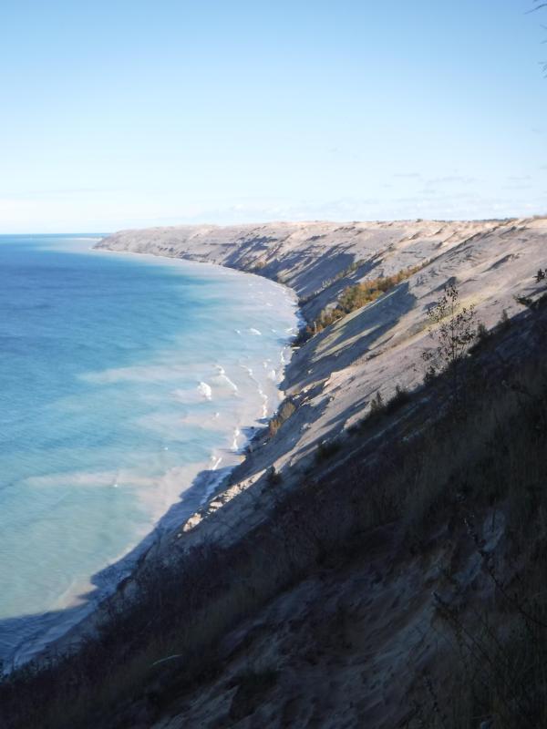
“Grand Sable Dunes”
~ National Park Service
In travelling up the coast from Sault Ste. Marie, the first 50 or 100 miles, the shore of Lake Superior exhibits, for much of the distance, a white sandy beach, with a growth of pines, silver fir, birch, &c., in the rear. This beach is strewed in places with much whitened and abraded drift-wood, thrown high on the banks by heavy waves in storms, and the action of ice in winter. This drift-wood is met with, at places, from one end of the lake to the other, which we found very convenient for firewood at our encampments. The sand on the southern shore terminates, in a measure, at Grand Sables, which are immense naked pure sand-hills, rising in an almost perpendicular form next to the lake, of from 200 to 300 feet high. Passing this section, we come to white sand-stone in the Pictured Rocks. Leaving these, we make the red sand-stone promontories and shore, at various points from this section, to the extreme end of the lake. It never afterwards wholly disappears. Between promontories of red stone are headlands, &c., standing out often in long, high irregular cliffs, with traverses of from 6, 7, to 8 miles from one to the other, while a kind of rounded bay stretches away inland, having often a sandy beach at its base, with pines growing in the forest in the rear. Into these bays, small rivers, nearly or quite shut in summer with sand, enter the lake.
The first trap-rock we met with, was near Dead river, and at some few points west of it. We then saw no more of it immediately on the coast, till we made the southern shore of Keweena point. All around the coast by the Anse, around Keweena bay, we found nothing but alternations of sand beaches and sand-stone cliffs and points. The inland, distant, and high hills about Huron river, no doubt, are mainly composed of trap-rock.

Detail from Map of the Mineral Lands Upon Lake Superior Ceded to the United States by the Treaty of 1842 With the Chippeway Indians.
~ Wisconsin Historical Society
Going west from Eagle river, we soon after lost both conglomerate and trap-rock, and found, in their stead, our old companions – red sand-stone shores, cliffs, and promontories, alternating with sandy or gravelly beaches.

Detail of the Ontonagon River, “Paul’s Cabin,” the Ontonagon Boulder, and the Porcupine Mountains from Map of the Mineral Lands Upon Lake Superior Ceded to the United States by the Treaty of 1842 With the Chippeway Indians.
~ Wisconsin Historical Society
The trap-rock east and west of the Portage river rises with, and follows, the range of high hills running, at most points irregularly, from northeast to southwest, parallel with the lake shore. It is said to appear in the Porcupine mountain, which runs parallel with Iron river, and at right angles to the lake shore. This mountain is so named by the Indians, who conceived its principal ridge bore a likeness to a porcupine; but, to my fancy, it bears a better resemblance to a huge hog, with its snout stuck down at the lake-shore, and its back and tail running into the interior. This river and mountain are found about twenty miles west of the Ontonagon river, which is said to be the largest stream that empties into the lake. The site for a farm, or the location of an agency, at its mouth, is very beautiful, and admirably suited for either purpose. The soil is good; the river safe for the entrance and secure anchorage of schooners, and navigable to large barges and keel-boats for twelve miles above its mouth. The trap range, believed to be as rich in copper ores as any part of Lake Superior, crosses this river near its forks, about fifteen miles above its mouth. The government have organized a mineral agency at its mouth, and appointed Major Campbell as agent to reside at it; than whom, a better selection could not have been made.
“Engraving depicting the Schoolcraft expedition crossing the Ontonagon River to investigate a copper boulder.”
~ Wisconsin Historical Society
Detail of the Montreal River, La Pointe, and Chequamegon bay from from Map of the Mineral Lands Upon Lake Superior Ceded to the United States by the Treaty of 1842 With the Chippeway Indians.
~ Wisconsin Historical Society
The nearest approach the trap-rock hills make to the lake-shore, beyond the Porcupine mountain, is on the Montreal river, a short distance above the falls. Beyond Montreal river, to La Pointe, we found red-clay cliffs, based on red sand-stone, to occur. Indeed, this combination frequently occurred at various sections of the coast – beginning, first, some miles west of the Portage.
From Copper harbor to Agate harbor is called 7 miles; to Eagle river, 20 miles; to the Portage, 40 miles; to the Ontonagon, 80 miles; to La Pointe, from Copper harbor, 170 miles. From the latter place to the river Brulé is about 70 miles; up which we expect to ascend for 75 miles, make a portage of three miles to the St. Croix river, and descend that for 300 miles to the Mississippi river.

Painting of Professor Douglass Houghton by Robert Thom. Houghton first explored the south shore of Lake Superior in 1840, and died on Lake Superior during a storm on October 13, 1845. Chequamegon Bay’s City of Houghton was named in his honor, and is now known as Houghton Falls State Natural Area.
Going back to Eagle river, at the time of our visit, we found at the mine Mr. Henshaw, Mr. Williams, and Dr. Jackson of Boston, and Dr. Houghton of Michigan, who was passing from Copper harbor to meet his men at his principal camp on Portage river, which he expected to reach that night. The doctor is making a rapid and thorough survey of the country. This work he is conducting in a duplicate manner, under the authority of the United States government. It is both a topographical and geological survey. All his surveyors carry sacks, into which they put pieces of rock broken from every prominent mass they see, and carry into camp at night, for the doctor’s examination, from which he selects specimens for future use. The doctor, from possessing extraordinary strength of constitution, can undergo exposure and fatigue sufficient to break down some of the hardiest men that can be found in the West. He wears his beard as long as a Dunkard’s; has a coat and patched pants made of bed ticking; wears a flat-browned ash-colored, wool hat, and a piece of small hemp cord off a guard chain; and, with two half-breed Indians and a small dog as companions, embarks in a small bark, moving and travelling along the lake shore with great celerity.
Probably no company on Lake Superior has had a longer and harder struggle against adversity than the Phœnix. The original concern, the Lake Superior Copper Company, was among the first which operated at Lake Superior after the relinquishment of the Indian rights to this country in 1843. The trustees of this early organization were David Henshaw and Samuel Williams of Boston, and D. G. Jones and Col. Chas. H. Gratiot, of Detroit; Dr. Charles T. Jackson examined the veins on the property, and work was begun in the latter part of the year 1844. The company met with bad luck from the start, and, the capital stock having become exhausted, it has been reorganized several times in the course of its history.”
~ The Lake Superior Copper Properties: A Guide to Investors and Speculators in in Lake Superior Copper Shares Giving History, Products, Dividend Record and Future Outlook for Each Property, by Henry M. Pinkham, 1888, page 9.
We all sat down to dinner together, by invitation of Mr. Williams, and ate heartily of good, wholesome fare.
After dinner we paid a visit to the shafts at the mine, sunk to a considerable depth in two or three places. Only a few men were at work on one of the shafts; the others seemed to be employed on the saw-mill erecting near the mouth of the river. Others were at work in cutting timbers, &c.
They had also a crushing-mill in a state of forwardness, near the mine.
It is what has been said, and put forth about the value of this mineral deposite, which has done more to incite and feed the copper fever than all other things put together.
Professor Charles Thomas Jackson.
~ Contributions to the History of American Geology, plate 11, opposite page 290.
Dr. Jackson was up here last year, and has this year come up again in the service of the company. Without going very far to explore the country elsewhere, he has certainly been heard to make some very extravagant declarations about this mine,- such as that he “considered it worth a million of dollars;” that some of the ore raised was “worth $2,000 or $3,000 per ton!” So extravagant have been the talk and calculations about this mine, that shares (in its brief lease) have been sold, it is said, for $500 per share! – or more, perhaps!! No doubt, many members of the company are sincere, and actually believe the mine to be immensely valuable. Mr. Williams and General Wilson, both stockholders, strike a trade between themselves. One agrees or offers to give the other $36,000 for his interest, which the other consents to take. This transaction, under some mysterious arrangement, appears in the newspapers, and is widely copied.
Without wishing to give an opinion as to the value and permanency of this mine, (in which many persons have become, probably, seriously involved,) even were I as well qualified to do so as some others, I can only state what are the views of some scientific and practical gentlemen with whom I fell in while in the country, who were from the eastern cities, and carefully examined the famous Eagle river silver and copper mine. I do not allude to Dr. Houghton; for he declines to give an opinion to any one about any part of the country.
“The remarkable copper-silver ‘halfbreed’ specimen shown above comes from northern Michigan’s Portage Lake Volcanic Series, an extremely thick, Precambrian-aged, flood-basalt deposit that fills up an ancient continental rift valley.”
~ Shared with a Creative Commons license from James St. John
They say this mine is a deposite mine of native silver and copper in pure trap-rock, and no vein at all; that it presents the appearance of these metals being mingled broadcast in the mass of trap-rock; that, in sinking a shaft, the constant danger is, that while a few successive blasts may bring up very rich specimens of the metals, the succeeding blast or stroke of the pick-axe may bring up nothing but plain rock. In other words, that, in all such deposite mines, including deposition of diffused particles of native meteals, there is no certainly their PERMANENT character. How far this mine will extend through the trap, or how long it will hold out, is a matter of uncertainty. Indeed, time alone will show.
It is said metallic veins are most apt to be found in a permanent form where the mountain limestone and trap come in contact.
I have no prejudice against the country, or any parties whatever. I sincerely wish the whole mineral district, and the Eagle mine in particular, were as rich as it has been represented to be. I should like to see such vast mineral wealth as it has been held forth to be, added to the resources of the country.
Unless Dr. Pettit has succeeded in fixing the vein of black oxide in the side of the mountain or hill, it is believed by good judges that no permanent vein has yet been discovered, as far as has come to their knowledge, in the country!! That much of the conglomerate and trap-rock sections of the country, however, presents strong indications and widely diffused appearances of silver and copper ores, cannot be denied; and from the great number of active persons engaged in making explorations, it is possible, if not probable, that valuable veins may be discovered in some portions of the country.
To find such out, however, if they exist, unless by accident, must be the work of time and labor – perhaps of years – as the interior is exceedingly difficult, or rather almost impossible, to examine, on account of the impenetrable nature of the woods.
During our long and tedious journey, we were favored with a good deal of fine weather. We however experienced, first and last, five or six thunderstorms, and some tolerably severe gales.
Coasting for such a great length, and camping out at night, was not without some trials and odd incidents – mixed with some considerable hardships.
On the night before we reached La Pointe, we camped on a rough pebbly beach, some six or eight miles east of Montreal river, under the lea of some high clay cliffs. We kindled our fire on what appeared to be a clear bed of rather large and rounded stones, at the mouth of a gorge in the cliffs.

Topographic map of the gorge in the cliffs at Little Girl’s Point County Park.
~ United States Geological Survey
Next morning early, the fire was rekindled at the same spot, although some rain had falled in the night it being still cloudy, and heavy thunder rolling, indicating an approaching storm. I had placed some potatoes in the fire to roast, while some of the voyageurs were getting other things ready for breakfast; but before we could get anything done, the rain down upon us in torrents. We soon discovered that we had kindled our fire in the bed of a wet weather creek. The water rapidly rose, put out the fire, and washed away my potatoes.
We had then to kindle a new fire at a higher place, which was commenced at the end of a small crooked log. One of the voyageurs had set the frying-pan on the fire with an Indian pone or cake an inch thick, and large enough to cover the bottom it. The under side had begun to bake; another hand had mixed the coffee, and set the coffee-pot on to boil; while a third had been nursing a pot boiling with pork and potatoes, which, as we were detained by rain, the voyageurs thought best to prepare for two meals. One of the part, unfortunately, not observing the connexion between the crooked pole, and the fire at the end of it, jumped with his whole weight on it, which caused it suddenly to turn. In its movement, it turned the frying-pan completely over on the sand, with its contents, which became plastered to the dirt. The coffee-pot was also trounced bottom upwards, and emptied its contents on the sand. The pot of potatoes and pork, not to be outdone, turned over directly into the fire, and very nearly extinguished it. We had, in a measure, to commence operations anew, it being nearly 10 o’clock before we could get breakfast. When near the Madelaine islands, (on the largest of which La Pointe is situated,) the following night, our pilot, amidst the darkness of the evening, got bewildered for a time, when we thought best to land and camp; which, luckily for us, was at a spot within sight of La Pointe. Many trifling incidents of this character befell us in our long journey.
Lake Bands:
“Ki ji ua be she shi, 1st [Chief].
Ke kon o tum, 2nd [Chief].”
Pelican Lakes:
“Kee-che-waub-ish-ash, 1st chief, his x mark.
Nig-gig, 2d chief, his x mark.“
Lac Courte Oreilles Band:
At the mouth of the Montreal river, we fell in with a party of seventeen Indians, composed of old Martin and his band, on their way to La Pointe, to be present at the payment expected to take place about the 15th of August.
They had their faces gaudily painted with red and blue stripes, with the exception of one or two, who had theirs painted quite black, and were said to be in mourning on account of deceased friends. They had come from Pelican lake (or, as the French named it, Lac du Flambeau,) being near the headwaters of the Wisconsin river, and one hundred and fifty miles distant. They had with them their wives; children, dogs, and all, walked the whole way. They told our pilot, Jean Baptiste, himself three parts Indian, that they were hungry, and had no canoe with which to get on to La Pointe. We gave them some corn meal, and received some fish from them for a second supply. For the Indians, if they have anything they think you want, never offer generally to sell it to you, till they have first begged all they can; then they will produce their fish, &c., offering to trade; for which they expect an additional supply of the article you have been giving them. Baptiste distributed among them a few twists of tobacco, which seemed very acceptable. Old Martin presented Baptiste with a fine specimen of native copper which he had picked up somewhere on his way – probably on the headwaters of the Montreal river. He desired us to take one of his men with us to La Pointe, in order that he might carry a canoe back to the party, to enable them to reach La Pointe the next day, which we accordingly complied with. We dropped him, however, at his own request, on the point of land some miles south of La Pointe, where he said he had an Indian acquaintance, who hailed him from shore.
Having reached La Pointe, we were prepared to rest a few days, before commencing our voyage to the Mississippi river.
Of things hereabouts, and in general, I will discourse in my next.
In great haste I am,
Very respectfully,
Your obedient servant,
MORGAN.
To be continued in La Pointe…
Wisconsin Territory Delegation: Copper Harbor
April 11, 2016
By Amorin Mello
A curious series of correspondences from “Morgan”
… continued from Mackinac and Sault Ste Marie.

The Daily Union (Washington D.C.)
“Liberty, The Union, And The Constitution.”
July 22, 1845.
TERRITORY OF WISCONSIN.

“The Wisconsin Territorial Seal was designed in 1836 by John S. Horner, the first secretary of the territory, in consultation with Henry Dodge, the first territorial governor. It features an arm holding a pick and a pile of lead ore.”
~ Wisconsin Historical Society
Gen. Henry Dodge, having been re-appointed Governor of the Territory, from which he had been “so ingloriously ejected after the election of 1840, by his political opponents, his valuable services” have ceased as a member of Congress. It became necessary, of course, to elect another delegate. To choose a candidate for this office, a democratic convention was held at the capitol, in Madison, on the 25th June. Horatio N. Wells, of Milwaukie, was elected president; 18 ballots were taken before any one obtained a majority of the votes. Mr. Morgan L. Martin finally received 49, D. A. J. Upham 20, scattering 10. Mr. Martin accepts the nomination.
The Daily Union (Washington D.C.)
“Liberty, The Union, And The Constitution.”
July 29, 1845.
[From our regular correspondent.]
COPPER HARBOR, LAKE SUPERIOR,
JULY 15, 1845.
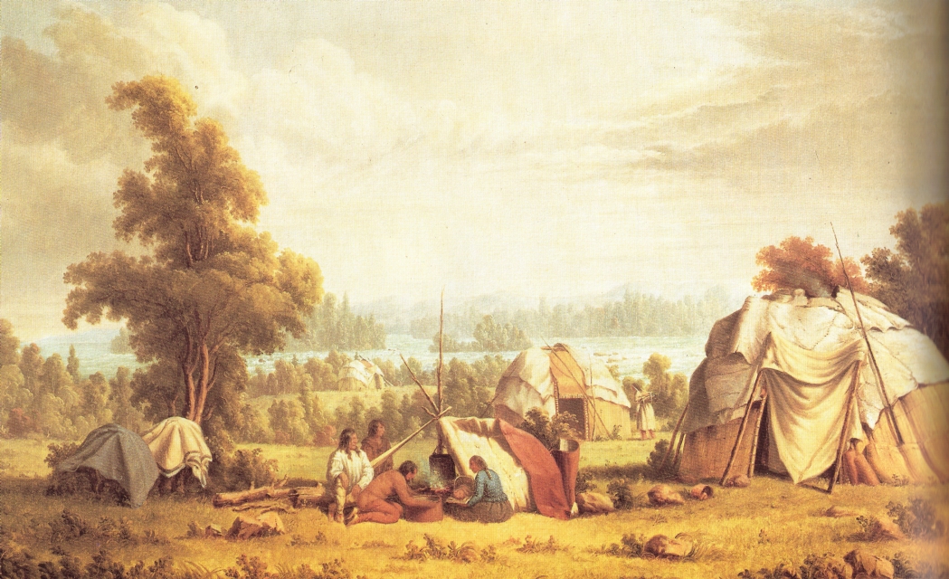
“Ojibwa village near Sault Ste Marie” by Paul Kane in 1845.
~ Wikipedia.org
Having chartered a Mackinac boat at the Sault St. Marie, and stored away our luggage, tents, provisions, with general camp equipage, &c., taking on board six able-bodied voyageurs, consisting of four descendants of Canadian French, and two half-breed Indians, (one of whom acted as our pilot,) we set off, on the 4th of July, at about 11, a.m., to coast it up the southern shore of Lake Superior, to Copper Harbor – a distance, by the way we were to travel, of over 280 miles.
The heat of the sun, combined with the attacks of musquitoes at night, annoyed us very much at first. I have seen what musquitoes are in many other parts of the world; but I never found them more abundant and troublesome than at some points on Lake Superior.
It took us eleven days’ voyaging to reach this place, travelling all day when the weather was favorable, and lying by when it became stormy, with strong head winds. At night we camped on shore, and generally rose every morning between three and four o’clock, being under way on the water as soon as it was light enough to see. In voyaging in this way, we had a better opportunity to view the country as we passed along, many portions of which were full of interest – such as the Grand Sable, the Pictured Rocks, &c. The former are immense cliffs, rising to the height of two hundred feet above the level of the lake, being composed of pure sand, and reaching about six miles in length along the lake shore, with its front aspects almost perpendicular. It is said, the sand of which they are formed maintains its perpendicularity by reason of the moisture which it derives from the vapor of the lake. The summits contain no vegetation, save here and there a solitary shrub or bush. The rest of this high, bold, and solemn mass stretches out, in silent and naked grandeur, beneath the horizon, forming a picture of desolate sublimity. We passed it late in the afternoon, during a bright and clear sky, when the sun had just begun to hide himself behind its huge masses.
“Once a vessel was sailing over a northern ocean in the midst of the short, Arctic summer. The sun was hot, the air was still, and a group of sailors lying lazily upon the deck were almost asleep, when an exclamation of fear from one of them made them all spring to their feet. The one who had uttered the cry pointed into the air at a little distance, and there the awe-stricken sailors saw a large ship, with all sails set, gliding over what seemed to be a placid ocean, for beneath the ship was the reflection of it.”
~ Round-about Rambles in Lands of Fact and Fancy, by Frank Richard Stockton, 1910, page 277.
I have never travelled on a sheet of water where the effect of mirage is so frequently witnessed as on Lake Superior. For instance: early on Sunday morning, the 6th of July, soon after leaving our encampment, near White Fish Point, the morning being slightly foggy, we saw distinctly the Grand Sable, which must have been fifty miles in advance of us, with intervening points of land. I witnessed a similar instance of mirage when coming through Lake Huron. Early one morning, I distinctly saw Drummond’s island, which the officers of the boat assured me was eighty miles off!
I have never seen an atmosphere through which I could discern objects so far as on Lake Superior. Cliffs, headlands, islands, and hills, which often appeared as if within a mile or two of us, were found, on being approached, to be from five to ten miles off. Hence, in making what “voyageurs” called “traverses” – that is, a passage in a direct line from one headland to another, instead of curving with the shore of the lake – inexperienced voyageurs are very liable to be deceived, by supposing the distance to be short, when it is in reality very long. In making which, should a strong wind spring up from shore, a small boat would be liable to be blown out to sea, and the boat and people run the hazard of being lost. We had some brief but painful experience of this deception in apparent distance, by attempting one morning, after having camped at the mouth of the Dead river, to sail before what seemed to be a fair wind from Presqu’isle to Granite Point; but we had not made much over half the distance, when the wind suddenly changed to the west, and blew a gale on our beam, and we came very near being blown out into the open lake – which is just about equivalent to being blown into the Atlantic, for the storms are just as strong, and the waves roll equally as high. Finding we were going to leeward, we dropped sail, and took to our oars; and, although within half a mile of the point we wished to make, it took us hard oaring for about an hour to reach it.

“Pictured Rocks Splash © Lou Waldock”
~ National Park Service
I have never seen a sheet of water, where the wind can succeed in so suddenly throwing the water into turbulent waves, as on Lake Superior. This is owing to its freshness, making it so much lighter than salt water. One night, just as we had oared past a perpendicular red sandstone cliff a mile or two in length, where it would have been impossible for us to make a landing, and had reached a sand beach at the mouth of a small river, where we camped, the surface of the lake up to that time being as smooth as glass, we had no sooner pitched our tents, than a violent wind sprang up from the northeast, and blew a gale nearly all night, shifting from one point to another. In fifteen or twenty minutes after the commencement of the blow, the water of the lake seemed lashed into a fury of commotion, in which our boat could scarcely have survived.
The grandest scenery beheld in the whole route was that presented by the celebrated “Pictured Rocks.” They lie stretched out for nine miles in length, a little east of Grand island. They are considered very dangerous to pass by voyageurs, who generally select favorable spells of weather for the trip.
“Grand Sable Dunes”
~ National Park Service
On the morning of Tuesday, the 8th instant, soon after leaving our camp, the fog cleared up, sufficient to give us a glimpse of these stupendous sandstone cliffs. As the sun rose, the fog became dispersed, and its brilliant beams fell upon and illuminated every portion of them.
They rise in perpendicular walls from the water of the lake shore, to the height of from 200 to 300 feet. They are so precipitous, that they in some places appear to lean over the lake at top, to which small trees are seen leaning over the lake, hanging by their frail roots to the giddy crags above. At one point, a small creek tumbles over a portion of them in a cascade of 100 feet in height. They stretch for nine miles in length, and in all that distance there are only two places where boats can land – one cove being called the Chapel, and the second Miner’s river.
Photograph of “Chapel Rock” by David Kronk.
~ National Park Service
“Bridalveil Falls”
~ National Park Service
So deep is the water, that a boat can pass close along shore, almost touching the cliffs. Indeed, a seventy-four-gun ship can ride with perfect safety within ten feet of their base. Taken altogether, their solemn grandeur, and the awful sublimity of their gigantic forms and elevation, far surpass anything of the kind, probably, on the continent, if not in the world. Next to the Falls of Niagara, they are the greatest natural curiosity they eyes of man can behold. When steamboats are introduced on Lake Superior, they cannot fail to attract the attention of the tourist. They contain vast caves, one of which is only 30 feet wide at its mouth, but, on entering it, suddenly expands to 200 feet in width, beneath a lofty dome of 200 feet high. Different portions of the cliffs go by different names – such as the “Portailles,” the “Doric Rock,” the “Gros Cap,” the “Chapel,” &c. We went into a small bay at the base of the “Chapel,” which consists of an immense mass of rude sandstone, with trees growing on it, expanded in the form of an arch, its extremities resting on irregularly shaped columns, to the number of three or four under each end. Beneath the arch, a deep gorge enters the lake, crowded and choked with luxuriant vegetation. It appeared to me like the finest and most natural Druidical altar to be seen anywhere, not excepting even Stonehenge. Near the Chapel, a brisk little stream falls rapidly over the rocks into the water below. It is impossible to do justice to the splendid appearance of “the Pictured Rocks,” so called on account of the [???? ????? ???????] composed being mixed with iron ore, drippings from which they have stained the surface of the rocks with a variety of tints. The painter alone can convey any just image to the mind’s eye of these grand cliffs, and they will afford him a hundred views, every one of which will differ from the other. I will defy anybody to visit them, as we did, on a clear, bright day, when the lake is smooth, in an open boat, close by the side of them, without having his expectations of their natural grandeur far surpassed.
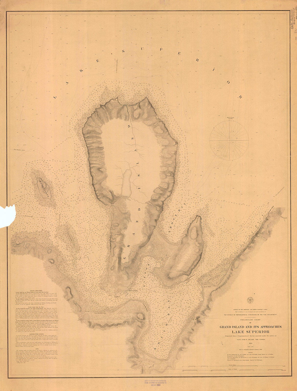
“Preliminary Chart of Grand Island and Its Approaches, Lake Superior, 1859″
~ Maritime History of the Great Lakes
Boats have sometimes been caught in the Chapel by sudden, high, and contrary winds, and compelled to remain there for three or four days, before being able to proceed. A few miles beyond the “Pictured Rocks,” we came to Grand Island, where, entering its harbor, we stopped at Mrs. Williams’s place, the only settlement on the island, which is very large. This is one of the most splendid and safe harbors on Lake Superior – perfectly land-locked on every side, and extensive enough to contain a large fleet of vessels, being easy of ingress or egress. From Grand Island we continued to persevere in our voyage, and finally reached Copper Harbor, via the Anse, in eleven days from the Sault Ste. Marie.
“The beginning of Methodism in the Upper Peninsula of Michigan west of Sault Ste. Marie is credited to the missionary trail blazers who came to Kewawenon, now known as Keweenaw Bay. The first, in 1832 with John Sunday a converted Canadian Indian. In 1833 Rev. John Clark continued the mission work started by Sunday. He was followed by Rev. Daniel Chandler in 1834 who remained here for two years. Rev. Clark was appointed Superintendent of Lake Superior Missions in 1834 and was instrumental in having a mission house and church school house erected during Rev. Chandler’s mission stay. Houses for the local natives were also erected along the lake shore in the vicinity of the present Whirl-I-Gig Road”
At the Anse we fell in with Mr. Ord, the United States Indian agent at the Sault Ste. Marie, who was on a visit to the Indians at that point, to take the census, and to hold a talk with their chiefs in council. We arrived at the Anse a few hours before the council began. The chiefs all sat around a hall on wooden benches, while Mr. Ord, with the interpreter, was seated at the head of the circle. Many of the Indians were fine-looking men. They had a great many petty grievances to relate to the agent, who listened to them with patient attention. The Chippewas about the Anse are said to be much better off than those who trade to La Pointe, at the upper end of the lake.
The Methodists have a missionary station and school on the east side of the bay of Keweewena, and near its head; around which there is an Indian village, consisting of 600 or 700 souls. The Catholics have also a missionary station on the opposite side of the bay, which is here only about a mile or two wide.

Reverend William Hadley Brockway: “The first Methodist minister licensed to preach in the State of Michigan.”
~ Geni.com
The government employs at this Indian post one blacksmith, (Mr. Brockaway,) one carpenter, (Mr. Johnson,) and one teacher, in the person of the Methodist minister. We left the Anse about half-past 4 o’clock, p.m., sailing before a fair wind, reaching the mouth of the Portage, or Sturgeon river, where we camped on a flat point of land severely infested by musquitoes, with the heat equal to any in intensity (which had prevailed during the day) that I ever experienced. At Fort Wilkins, Copper Harbor, on the same day, I have since learned the mercury rose to 100° in the shade. This would seem to be a tremendous degree of heat for such a high latitude, the fort standing on the parallel of 47° 30′.

Detail of “Keewaiwona Bay” with “Anse” and the “Old Indian Village” from Map of the Mineral Lands Upon Lake Superior Ceded to the United States by the Treaty of 1842 With the Chippeway Indians.
~ Wisconsin Historical Society
During the night, we could occasionally hear the plunges of sturgeon floundering in the water, which abound in this lake river. A thunder-storm, also, passed near, before day, which had the effect to cool the air. About half-past 1 o’clock, I was awakened by the loud talk and whooping of Indians, carried on between our Indian half-breed pilot, Jean Baptiste, and a lot of freshly-arrived Indian voyageurs, conducted in the Indian dialect. On looking out of our tent, I discovered a plain-dressed Yankee-looking man, standing in front of it. On hailing him, he proved to be the Rev. Mr. Brockaway, a Methodist minister, and superintendent of Indian missions in this part of the world. He had been on a visit to the missions at the upper end of the lake, and was returning to the Anse, which he was anxious to reach in time to attend to Sunday morning service, (the next day being Sunday,) and from whence he expected to proceed to the Sault Ste. Marie, where he is stationed in the capacity of chaplain to the garrison at that post. He said he had, on reaching our encampment, travelled that day from the Ontonagon river, 80 miles distance, in a bark canoe, accompanied by four Indian voyageurs. After the Indians had prepared some food, with tea, of which Mr. B. and themselves partook, they again set off for the Anse, about 15 miles from us, where they must have arrived at a very early hour. This despatch far exceeded the expedition of our movements, and displayed unusual activity on the part of the enterprising missionary of an extensive and practical church organization.
We rose at three a.m., and in half an hour were under way on the lake. In these latitudes it is light at three in the morning; twilight continuing till eight and nine in the afternoon.
The following night we camped near the mouth of Little Montreal river, in full view of the high mountains or large round hills of trap rocks running along the peninsula of Keweewena towards its extreme point, some of which rise to the elevation of eight hundred feet above the level of the lake.
The next day, after some detention, we reached Copper Harbor, and landed near the United States Mineral Agency on Porter’s island, where we found quite a village, consisting of white canvas tents of various sizes and forms, occupied by miners, geologists, speculators, voyageurs, visitors, &c.
The only tenement on the island is a miserable log-cabin, in which General Stockton, for the want of better quarters, is compelled to keep his office. The room which he occupies, is only about eight feet square – just large enough to admit a narrow bed for himself, a table, and two or three chairs. In this salt-box of a room, he is compelled to transact all the business relating to the mineral lands embraced within this important agency. As many as a dozen men at a time are pressing forward to his “bee gum” apartment, endeavoring to have their business transacted.
The office of the surveyor of this mineral lands, in charge of Mr. Gray, at this agency, is still worse adapted to the transaction of public business. He is compelled to occupy the garret of the log-cabin, with a hole cut through the logs in the gable to serve as a window. In this garret he is obliged to have all his draughting performed, subject to the constant interruption of parties wishing to see plans of the mineral lands. It would seem almost impossible, under such circumstances, for the officers to avoid making mistakes; yet, by dint of unwearied labor and attention to their official duties, they have conducted their affairs with an accuracy and despatch highly creditable to them.
The government has been fortunate in the selection of its agents in the mineral region of Lake Superior. To untiring industry, punctuality, and close attention to business, they unite, in a high degree, the bland, mild, and patient bearing of gentlemen.
Gen. Stockton’s labor are severe and perplexing. He is continually beset by crowds of applicants for locations, all anxiously pressing forward to secure leases for copper-mines – among whom are found some utterly reckless of all principles of justice and equity, who endeavor to bend the agent into a compliance with their unjust and unreasonable demands – such as wishing him to supersede prior locations for their benefit, or to grant locations evidently intended to cover town sites, beyond the bounds of his agency, where no mineral exists, which he has no authority to grant; and because he has, in every instance of the kind, resisted their unreasonable applications, he has not escaped making a few enemies among such persons, who are collecting together to abuse and misrepresent him. Considering the cramped quarters furnished him by the government, and the great rush of people upon him from all quarters, under the excitement of a copper fever raging at its height, and many anxious to obtain exclusive advantages, it is surprising how he has succeeded so well as he has done in giving such general satisfaction. His official duties are discharged with a promptitude, fidelity, firmness, and impartiality, which are creditable to the public service. He seems peculiarly fitted, both by habit and nature, for the discharge of the responsible duties involved in the administration of an agency established in a wild an uninhabited country, being traversed at present by bands of people in search of mineral treasures, as diversified in character, dispositions, &c., as the various sections of country from whence they come – many of whom are by no means scrupulous as to the means for promoting their own interest – who probably suppose they can play the same game in the copper mineral region that was practiced in the early leasing of the lead mineral districts of Illinois: that is, seize upon government lands, work and raise mineral ore, cheat the government, and sell rights, where they have never had a claim.
It is enough to say that, while such men as Gen. Stockton, Major Campbell, and Mr. Gray, remain in office on the southern shore of Lake Superior, all such desperadoes will be completely foiled and disappointed. The frauds committed on the government in the working of the lead-mines, cannot be repeated in the copper mineral region of the United States. When fraudulently-inclined adventurers find they cannot make the faithful officers of government stationed in this quarter swerve from the strict and impartial discharge of their duty, they will probably unite for the purpose of operating upon government to procure their removal, and endeavor to get men in their places more likely to act as plaint tools in promoting their selfish ends.
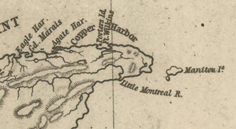
Detail of Porter’s Island, Fort Wilkins, Copper Harbor, Agate Harbor, Eagle Harbor, and Little Montreal River along the tip of the Keweenaw Peninsula from Map of the Mineral Lands Upon Lake Superior Ceded to the United States by the Treaty of 1842 With the Chippeway Indians.
~ Wisconsin Historical Society
The agency being on a narrow small island, half a mile from the mainland, makes it very inconvenient. The island does not afford sufficient timber for fire-wood, and in winter is isolated by ice, &c. It should by all means be removed to the main shore, and placed near Fort Wilkins, which is nearly two miles distant on the main land, or removed up to Eagle Harbor, which is a far preferable and more convenient site for the agency.
There is no question by the great range of trap-rock, running parallel with the southern shore of Lake Superior for a great distance, is [????????] with many valuable veins of copper ore; but to find them and develop them, must be the work of time. The impenetrable stunted forest seems to be little else than a thick, universal hedge, formed by the horizontal interlocked limbs of dwarf white cedars, intermingled with tamarack, birch, and maple. Persons who attempt to penetrate through them, without being protected by a mail of dressed buck-skin, have their clothes soon slit and torn from their bodies in shreds.
Painting of Professor Douglass Houghton by Robert Thom. Houghton first explored the south shore of Lake Superior in 1840, and died on Lake Superior during a storm on October 13, 1845. Chequamegon Bay’s City of Houghton was named in his honor, and is now known as Houghton Falls State Natural Area.
Dr. Houghton says, so considerable is the attraction of the trap-rock for the needle, that, on many places, when surveying over its ranges, he cannot rely upon it, and is compelled to run his lines by the sun and stellar observations.
So far as practicable mining operations have progressed in the country, the following seems to be the result:
At Eagle river several locations are being worked, superintended by Col. Gratiot, and on which from 70 to 80 men are employed.
At Agate Harbor another company have this season commenced operations under the direction of Mr. Larned, of New York, in whose service from 15 to 20 laborers find employment.
At Copper Harbor a company from Pittsburg are working a vein of black oxide of copper, under the superintendence of Dr. Pettit, who has from 30 to 40 hands employed under him. Besides these, there are other small parties at work in various directions. So that it would appear that mining in the United States copper mineral lands has fairly commenced.
Up to this time, the returns made to the agency by two of the above companies – the Eagle River, alias Boston Company, and the Pittsburg Company – amount to the following quantities of ore: The former have raised 500,000 lbs. of ore, worth not less than $125 per ton. The latter company have raised 6,670 lbs. of the black oxide copper ore, the value of which I do not exactly know.
Other companies are organizing for mining purposes, and will probably commence operations the present, or early in the next season.
The country still in the possession of the Chippewa Indians, embraced between the northwestern part of the lake and the British frontier, along Pigeon river, might be easily obtained from them by treaty. And, if poor in mineral wealth, it is a very rich soil and a good agricultural country; and by its acquisition we should at once extend and square out our possession and settlements to the British frontier, which should be protected by detached forts, extending along our lines, towards the Lake of the Woods. According to the present Indian boundary, it is made to pass along the water-line of the lake shore, from Pigeon river, around Fond du Lac; and when some distance east and south of the lake, strikes a straight line west from the Mississippi. The United States, by being cut off by this water-line from all landing sites for harbors or fortifications for one or two hundred miles of the western and northern shore of the lake, will be subject to great inconvenience.
The number of persons at present exploring or visiting the mineral region of Lake Superior, is supposed to amount to five hundred or more. The water of the lake, especially in deep places is remarkably fine and cool for drinking. The surface of the water in the upper part of the lake is said to be 900 feet above the level of the Atlantic. The shores of this great lake are, at many places, bold, high, grand, and solitary – the favorite resort of large eagles, several of which we saw – one, in particular, was a splendid specimen of the bald eagle. The lake abounds in white fish, trout, siskomit, and bass.

The Siscowet, or Fat Trout, is a subspecies of Lake Trout. Drawn by David Starr Jordan, and Barton Warren Evermann, 1911.
~ University of Washington
We caught fine trout almost every day during our voyage, by trailing a hook and line at the end of our boat. On the 13th inst., (the day before reaching Copper Harbor) we caught four fine large trout.
The scenery, climate, &c., of Lake Superior, strike the traveller as being peculiar, and something very different from what is met with in any part of the United States. Game is not abundant. With the exception of a porcupine, and a squirrel or two, we succeeded in killing nothing. Wild fowl, pigeon, and ducks are more plentiful. we killed many of the former, and two pheasants, during our trip. Our half-breed Indians skinned and dressed our porcupine for us, whose flesh we found quite palatable.
At one point I purchased the hind-quarters of a beaver, which some Indians had killed. The tail being considered a great delicacy, I sent it to Mr. Ord and party, who were then travelling in a separate boat, in company with us. We found the beaver meat, when dressed, most delicious food.
Our party, although sleeping in and exposed to showers for a day or two, all enjoyed excellent health. Many voyageurs are attacked with dysentery, but it is very slight, and easily overcome by the use of simple medicine.
I remain yours,
Very truly and respectfully,
MORGAN.
