The 1856 Reservation for Chief Buffalo’s Estate
November 5, 2025
Collected & edited by Amorin Mello
This is one of many posts on Chequamegon History exploring the original La Pointe Band Reservations of La Pointe County on Chequamegon Bay, now known as the Bad River and Red Cliff Reservations. Specifically, today’s post is about the 1856 Reservation for Chief Buffalo’s subdivision of the La Pointe Band and how it got selected in accordance with the Sixth Clause of the Second Article of the 1854 Treaty with the Chippewa at La Pointe:
1854 Treaty with the Chippewa at La Pointe
…

Map of La Pointe Band Reservations:
334 – Bad River Reservation
335 – La Pointe Fishing Reservation
341 – Chief Buffalo’s Reservation
342 – Red Cliff Reservation
18th Annual Report of the Bureau of American Ethnology to the Secretary of the Smithsonian Institution 1896-’97
Printed by U.S. Congress in 1899
ARTICLE 2. The United States agree to set apart and withhold from sale, for the use of the Chippewas of Lake Superior, the following-described tracts of land, viz:
…
6th [Clause]. The Ontonagon band and that subdivision of the La Pointe band of which Buffalo is chief, may each select, on or near the lake shore, four sections of land, under the direction of the President, the boundaries of which shall be defined hereafter. And being desirous to provide for some of his connections who have rendered his people important services, it is agreed that the chief Buffalo may select one section of land, at such place in the ceded territory as he may see fit, which shall be reserved for that purpose, and conveyed by the United States to such person or persons as he may direct.
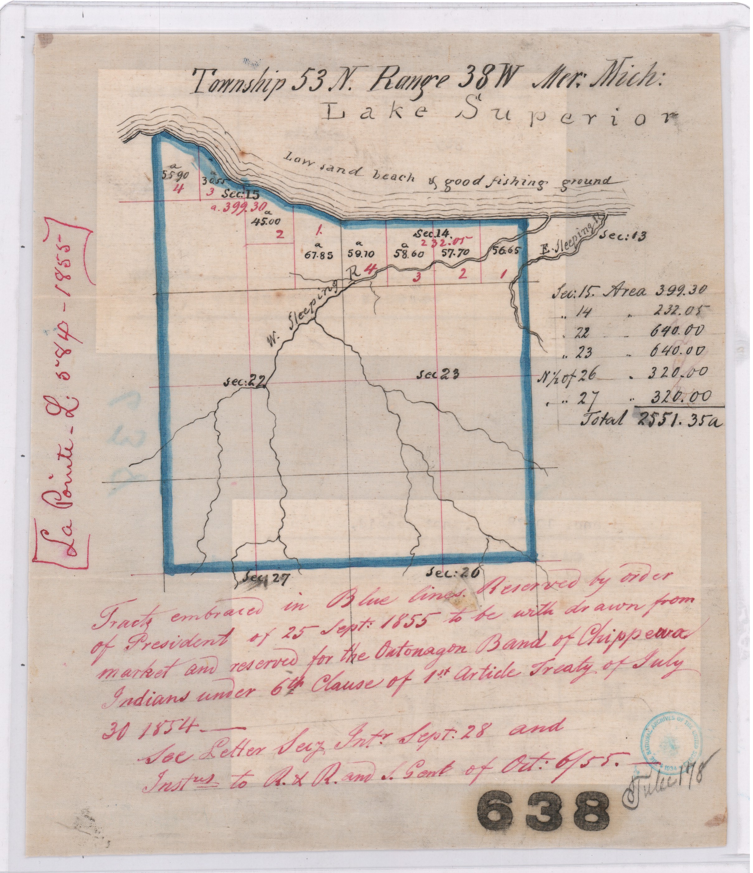
Map of “Tract embraced in blue lines reserved by order of President of 25 September 1855 to be withdrawn from market and reserved for the Ontonagon Band of Chippewa Indians“ on a “low sand beach & good fishing ground”.
Central Map File No. 638 (Tube No. 138)
NAID: 232923886 cites “La Pointe L.584-1855”.
The Ontonagon Band and Chief Buffalo’s Subdivision of the La Pointe Band got lumped together in this clause, so let’s review the Ontonagon Band first. Less than one year after the 1854 Treaty, the Ontonagon Band selected four square miles for their Reservation as approved by President Franklin Pierce’s Executive Order of September 25, 1855. Today the Ontonagon Band Reservation still has its original shape and size from 1855 despite heavy “checkerboarding” of its landownership over time.
In comparison to the Ontonagon Band Reservation, the history of how Chief Buffalo’s Reservation got selected is not so straightforward. Despite resisting and surviving the Sandy Lake Tragedy and Ojibwe Removal, making an epic trip to meet the President at Washington D.C., and securing Reservations as permanent homelands for the Chippewa Bands in the 1854 Treaty, Chief Buffalo of La Pointe died in 1855 before being able to select four square miles for his Subdivsion of the La Pointe Bands.
Fortunately, President Franklin Pierce’s Executive Order of February 21, 1856 withheld twenty-two square miles of land near the Apostle Islands from federal public land sales, allowing Chief Buffalo’s Estate to select four of those twenty-two square miles for their Reservation without competition from squatters and other land speculators, while other prime real estate in the ceded territory of La Pointe County was being surveyed and sold to private landowners by the United States General Land Office.
This 1856 Reservation of twenty-two square miles for Chief Buffalo’s Estate set the stage for what would eventually become the Red Cliff Reservation. We will return to this 1856 Reservation for Chief Buffalo’s Estate in several upcoming posts exploring more records about Red Cliff and the other La Pointe Band Reservations.

Maps marked “A” showing certain lands reserved by the 1854 Treaty:
Central Map File No. 793 (Tube 446)
NAID: 232924228 cites “La Pointe L.579-1855″.
Central Map File No. 816 (Tube 298)
NAIDs: 232924272 & 50926136 cites “Res. Chippewa L.516-1855”.

1878 Copy of President Franklin Pierce’s Executive Order of February 26, 1856 for Chief Buffalo’s Subdivision (aka “Red Cliff”).
NAID: 117092990
Office of Indian Affairs.
(Miscellaneous)
L.801.17.1878
Copy of Ex. Order of Feby. 21. 1856.
Chippewas (Red Cliff.)
Wisconsin.
Enc. in G.L.O. letter of Nov 23, 1878 (above file mark.)
in answer to office letter of Nov. 18, 1878.
Ex. Order File.

Secretary of the Interior
Robert McClelland
Department of the Interior
February 21, 1856
Sir,
I herewith return the diagram enclosed in your letter of the 20th inst, covering duplicates of documents which accompanied your letter of the 6th Sept. last, as well as a copy of the latter, the originals of which were submitted to the President in letter from the Department of the 8th Sept. last and cannot now be found.
You will find endorsements on said diagram explanatory of the case and an order of the President of this date for the withdrawal of the land in question for Indian purposes as recommended.
Respectfully
Your obt. Servt
R McClelland
Secretary
To
Hon Thos A Hendrick
Commissioner of the
General Land Office
(Copy)
General Land Office
September 6, 1855
Hon R. McClelland
Sec. of Interior
Sir:
Enclosed I have the honor to submit an abstract from the Acting Commissioner of Indian Affairs letter of the 5th instant, requesting the withdrawal of certain lands for the Chippewa Indians in Wisconsin, under the Treaty of September 30th, 1854, referred by the Department to this office on the 5th. instant, with orders to take immediate steps for the withdrawal of the lands from sale.
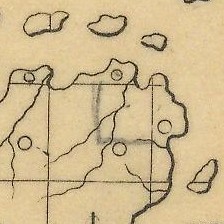
Detail of 1856 Reservation in pencil on “a map marked A.“
Central Map File No. 816 (Tube 298)
NAIDs: 232924272 & 50926136 cites “Res. Chippewa L.516-1855”.
In obedience to the above order I herewith enclose a map marked A. Showing by the blue shades thereon, the Townships and parts of Townships desired to be reserved, no portion of which are yet in market, to wit:
Township 51 N. of Range 3 West 4th Prin. Mer. Wis.
N.E. ¼ of Town 51 N ” 4 ” ” ” “.
Township 52 ” ” 3 & 4 ” ” ” “.
For the reservation of which, until the contemplated Selections under the 6th Clause of the Chippewa Treaty of 30th September 1854 can be made, I respectfully recommend that the order of the President may be obtained.
The requisite reports on the subject of the new surveys, and respecting preemption claims, referred to in the same order, will be prepared and communicated at an early day.
I am respectfully
Your Ob’t Serv’t
Thos. A. Hendricks
Commissioner
Department of the Interior
Feb. 20. 1856
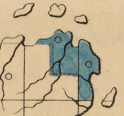
Detail of 1856 Reservation in blue on “duplicate of the original“.
NAID: 117092990
This plat represents by the blue shade, certain land to be withdrawn with a view to a reservation, under Chippewa Treaty of 30 Sept 1854, and as more particularly described in Commissioner of the General Land Office in letter of 6th Sept 1855. The subject was referred to the President for his sanction of the recommendation made in Secretary’s letter of 8th Sept 1855 and the original papers cannot now be found. This is a duplicate of the original, received in letter of Comm’r of the General Land Office of this date and is recommended to the President for his sanction of the withdrawal desired.
R. McClelland
Secretary

1856 Reservation in red and modern Red Cliff in brown. Although different in shape, both are roughly twenty-two square miles in size.
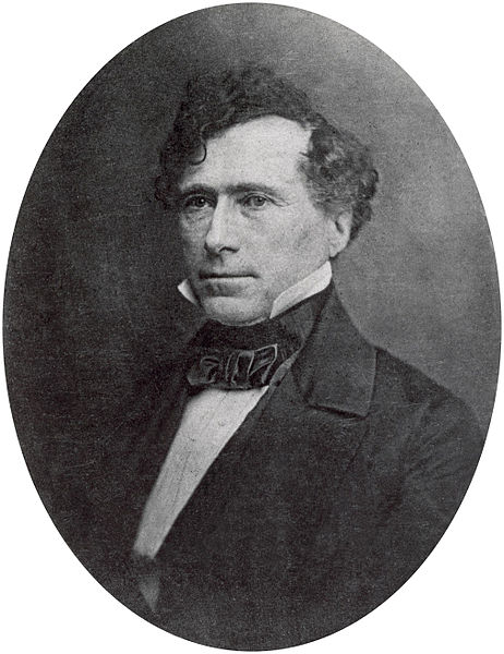
14th United States President
Franklin Pierce
February 21st 1856
Let the withdrawal be made as recommended.
