1837 Petitions from La Pointe to the President
January 29, 2023
Collected & edited by Amorin Mello
Letters Received by the Office of Indian Affairs:
La Pointe Agency 1831-1839
National Archives Identifier: 164009310
O. I. A. La Pointe J171.
Hon Geo. W. Jones
Ho. of Reps. Jany 9, 1838
Transmits petition dated 31st Augt 1837, from Michel Cadotte & 25 other Chip. Half Breeds, praying that the amt to be paid them, under the late Chip. treaty, be distributed at La Pointe, and submitting the names of D. P. Bushnell, Lyman M. Warren, for the appt of Comsr to make the distribution.
Transmits it, that it may receive such attention as will secure the objects of the petitioners, says as the treaty has not been satisfied it may be necessary to bring the subject of the petition before the Comsr Ind Affrs of the Senate.
Recd 10 Jany 1838
file
[?] File.
House of Representatives Jany 9th 1838

Sir
I hasten to transmit the inclosed petition, with the hope, that the subject alluded to, may receive such attention, as to secure the object of the petitioners. As the Chippewa Treaty has not yet been ratified it may be necessary to bring the subject of the petition before the Committee of Indian Affairs of the Senate.
I am very respectfully
Your obt svt
Geo W. Jones
C. A. Harris Esqr
Comssr of Indian Affairs
War Department

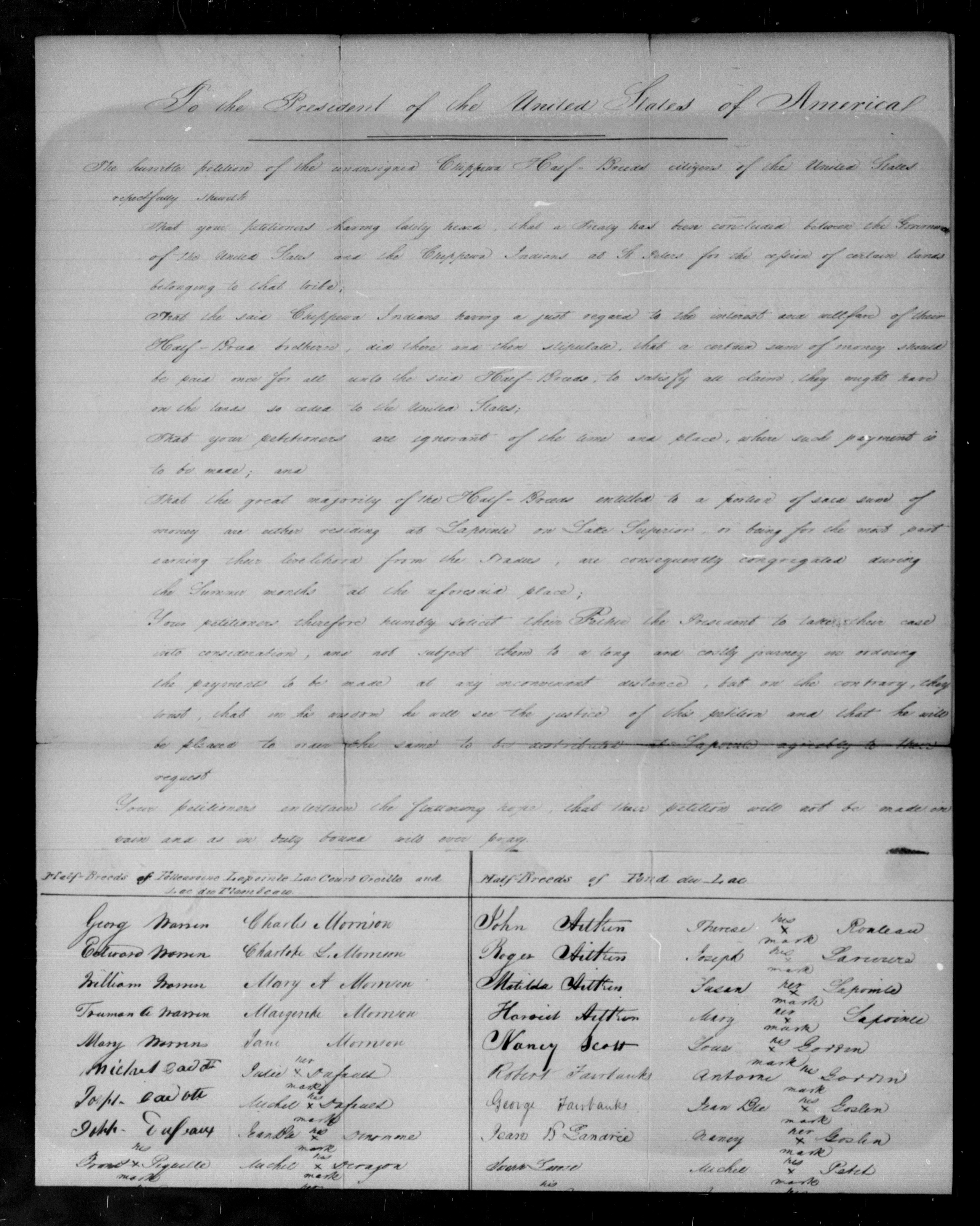
To the President of the United States of America
The humble petition of the undersigned Chippewa Half-Breeds citizens of the United Sates, respectfully Shareth:

Bizhiki (Buffalo), Dagwagaane (Two Lodges Meet), and Jechiikwii’o (Snipe, aka Little Buffalo) signed the 1837 Treaty of St Peters for the La Pointe Band.
That, your petitioners having lately heard that a Treaty had been concluded between the Government of the United Sates and the Chippewa Indians at St Peters, for the cession of certain lands belonging to that tribe:
ARTICLE 3.
“The sum of one hundred thousand dollars shall be paid by the United States, to the half-
breeds of the Chippewa nation, under the direction of the President. It is the wish of the
Indians that their two sub-agents Daniel P. Bushnell, and Miles M. Vineyard, superintend
the distribution of this money among their half-breed relations.”
That, the said Chippewa Indians X, having a just regard to the interest and welfare of their Half Breed brethren, did there and then stipulate; that, a certain sum of money should be paid once for all unto the said Half-Breeds, to satisfy all claim they might have on the lands so ceded to the United States.
That, your petitioners are ignorant of the time and place where such payment is to be made.
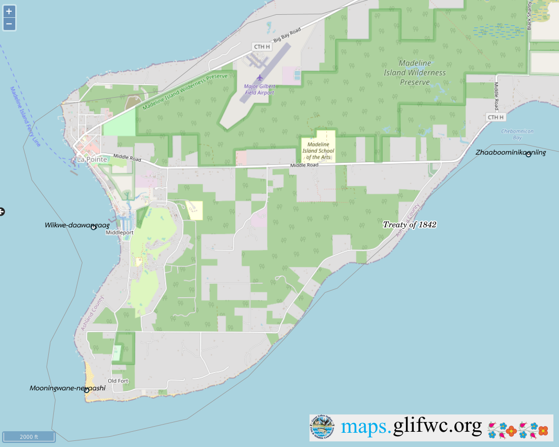
That the great majority of the Half-Breeds entitled to a distribution of said sum of money, are either residing at La Pointe on Lake Superior, or being for the most part earning their livelihood from the Traders, are consequently congregated during the summer months at the aforesaid place.
Your petitioners humbly solicit their father the President, to take their case into consideration, and not subject them to a long and costly journey in ordering the payments to be made at any inconvenient distance, but on the contrary they trust that in his wisdom he will see the justice of their demand in requiring he will be pleased to order the same to be distributed at Lapointe agreeable to their request.
Your petitioners would also intimate that, although they are fully aware that the Executive will make a judicious choice in the appointment of the Commissioners who will be selected to carry into effect the Provisions of said Treaty, yet, they would humbly submit to the President, that they have full confidence in the integrity of D. P. Bushnell Esqr. resident Indian Agent for the United States at this place and Lyman M Warren Esquire, Merchant.
Your petitioners entertain the flattering hope, that, their petition will not be made in vain, and as in duty bound will ever pray.
La Pointe, Lake Superior,
Territory of Wisconsin 31st August 1837
Michel Cadotte
Michel Bosquet X his mark
Seraphim Lacombe X his mark
Joseph Cadotte X his mark
Antoine Cadotte X his mark
Chs W Borup for wife & Children
A Morrison for wife & children
Pierre Cotte
Henry Cotte X his mark
Frances Roussan X his mark
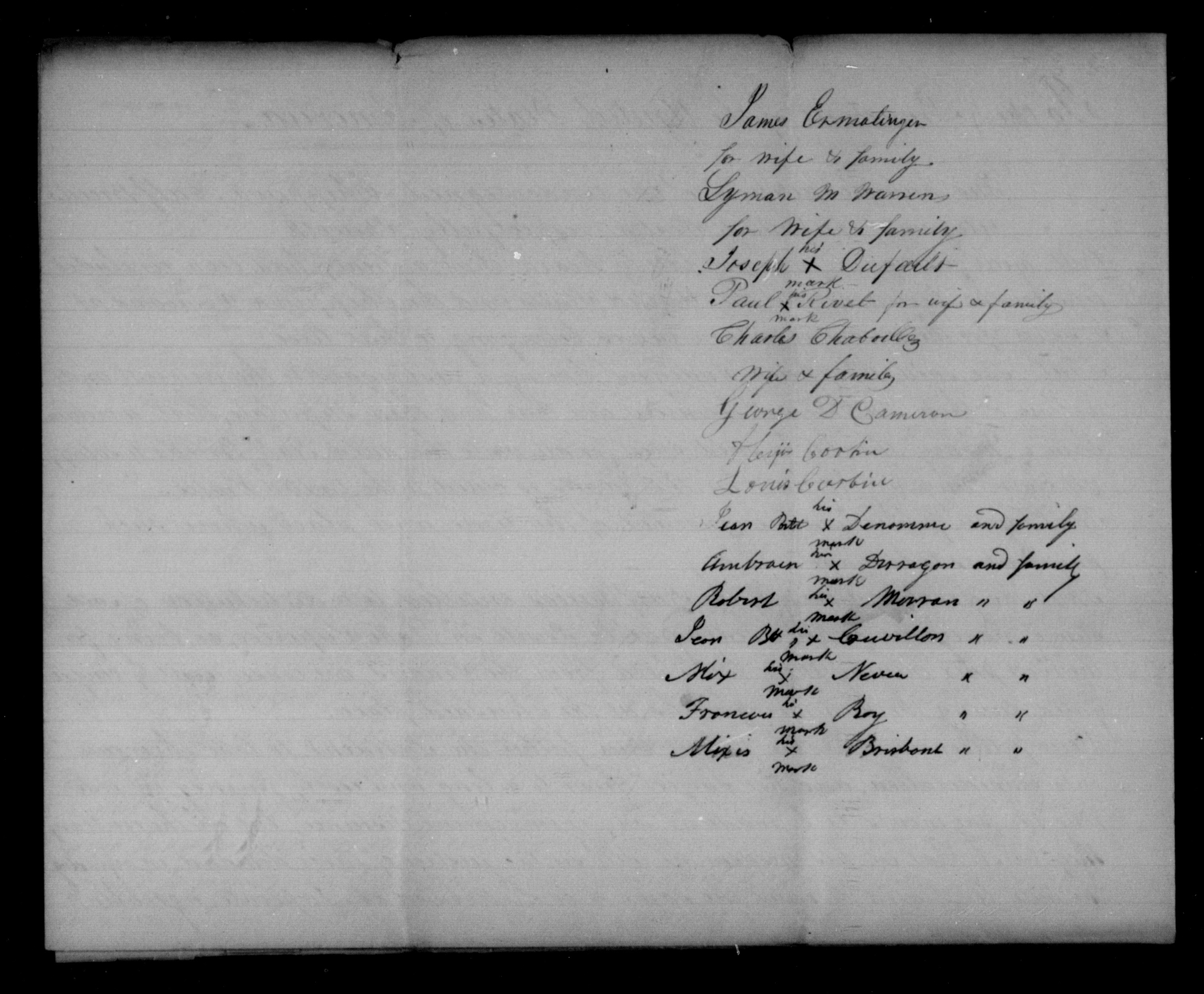
James Ermatinger for wife & family
Lyman M Warren for wife & family
Joseph Dufault X his mark
Paul Rivet X his mark for wife & family
Charles Chaboullez wife & family
George D. Cameron
Alixis Corbin
Louis Corbin
Jean Bste Denomme X his mark and family
Ambrose Deragon X his mark and family
Robert Morran X his mark ” “
Jean Bst Couvillon X his mark ” “
Alix Neveu X his mark ” “
Frances Roy X his mark ” “
Alixis Brisbant X his mark ” “
Signed in presence of G. Pauchene
John Livingston
O.I.A. La Pointe W424.
Governor of Wisconsin
Mineral Pt. Feby 19, 1838
Transmits the talk of “Buffalo,” a Chip. Chief, delivered at the La Pointe SubAgt, Dec. 9, 1837, asking that the am. due the half-breeds under the late Treaty, be divided fairly among them, & paid them there, as they will not go to St Peters for it, &c.
Says Buffalo has great influence with his tribe, & is friendly to the whites; his sentiments accord with most of those of the half-breeds & Inds in that part of the country.
File
Recd 13 March 1838
[?] File.
Superintendency of Indian Affairs
for the Territory of Wisconsin
Mineral Point, Feby 19, 1838

Sir,
I have the honor to inclose the talk of “Buffalo,” a principal chief of the Chippewa Indians in the vicinity of La Pointe, delivered on the 9th Dec’r last before Mr Bushnell, sub-agent of the Chippewas at that place. Mr. Bushnell remarks that the speech is given with as strict an adherence to the letter as the language will admit, and has no doubt the sentiments expressed by this Chief accord with those of most of the half-breeds and Indians in that place of the Country. The “Buffalo” is a man of great influence among his tribe, and very friendly to the whites.
Very respectfully,
Your obed’t sevt.
Henry Dodge
Supt Ind Affs
Hon C. A. Harris
Com. of Ind. Affairs
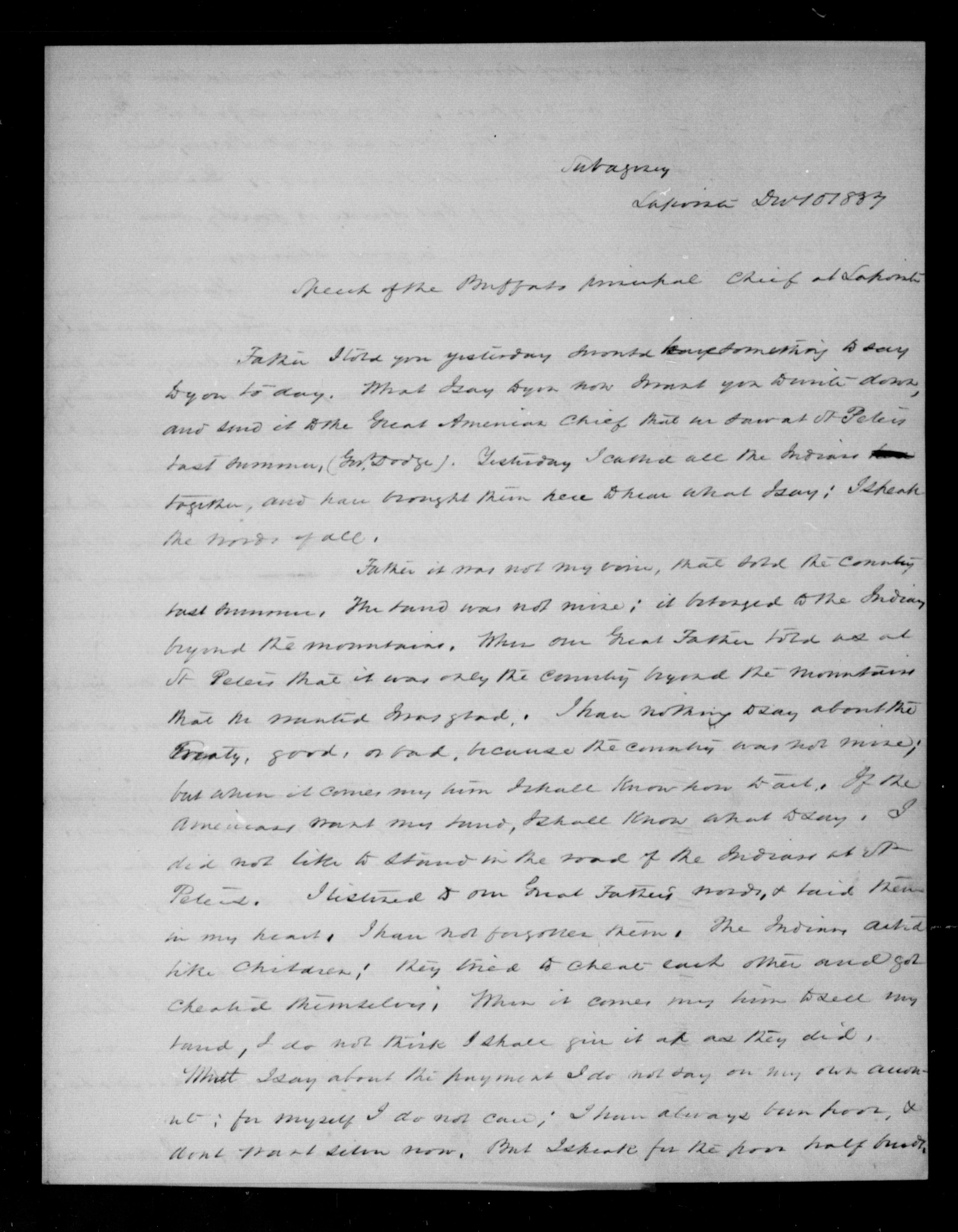
Subagency
Lapointe Dec 10 1837
Speech of the Buffalo principal Chief at Lapointe
Father I told you yesterday I would have something to say to you today. What I say to you now I want you to write down, and send it to the Great American Chief that we saw at St Peters last summer, (Gov. Dodge). Yesterday, I called all the Indians together, and have brought them here to hear what I say; I speak the words of all.
ARTICLE 1.
“The said Chippewa nation cede to the United States all that tract of country included
within the following boundaries:
[…]
thence to and along the dividing ridge between the waters of Lake Superior and those of the Mississippi
[…]“
Father it was not my voice, that sold the country last summer. The land was not mine; it belonged to the Indians beyond the mountains. When our Great Father told us at St Peters that it was only the country beyond the mountains that he wanted I was glad. I have nothing to say about the Treaty, good, or bad, because the country was not mine; but when it comes my time I shall know how to act. If the Americans want my land, I shall know what to say. I did not like to stand in the road of the Indians at St Peters. I listened to our Great Father’s words, & said them in my heart. I have not forgotten them. The Indians acted like children; they tried to cheat each other and got cheated themselves. When it comes my time to sell my land, I do not think I shall give it up as they did.
What I say about the payment I do not say on my own account; for myself I do not care; I have always been poor, & don’t want silver now. But I speak for the poor half breeds.
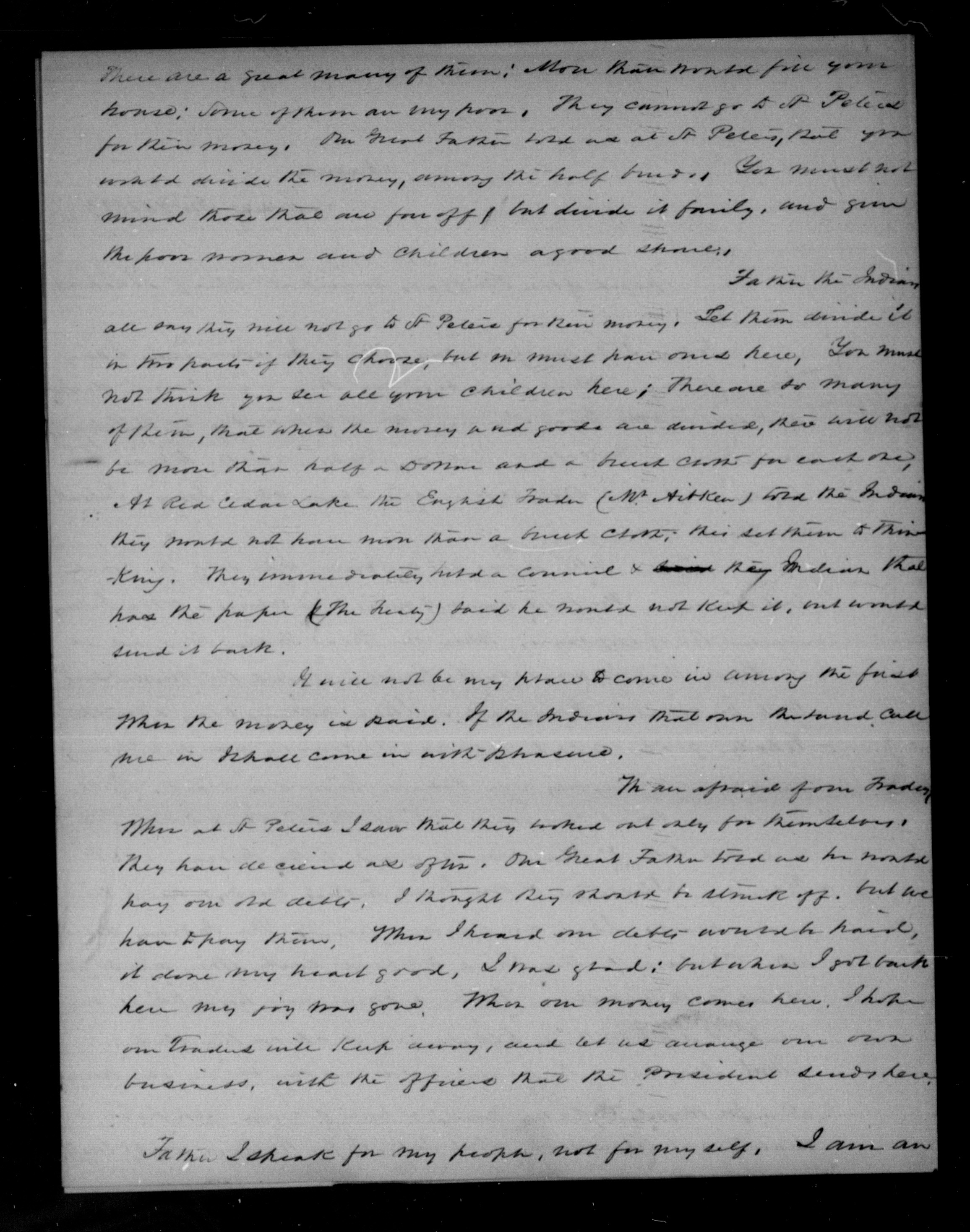
There are a great many of them; more than would fill your house; some of them are very poor They cannot go to St Peters for their money. Our Great Father told us at St Peters, that you would divide the money, among the half breeds. You must not mind those that are far off, but divide it fairly, and give the poor women and children a good share.
Father the Indians all say they will not go to St Peters for their money. Let them divide it in this parts if they choose, but one must have ones here. You must not think you see all your children here; there are so many of them, that when the money and goods are divided, there will not be more than half a Dollar and a breech cloth for each one. At Red Cedar Lake the English Trader (W. Aitken) told the Indians they would not have more than a breech cloth; this set them to thinking. They immediately held a council & their Indian that had the paper (The Treaty) said he would not keep it, and would send it back.
It will not be my place to come in among the first when the money is paid. If the Indians that own the land call me in I shall come in with pleasure.
ARTICLE 4.
“The sum of seventy thousand dollars shall be applied to the payment, by the United States, of certain claims against the Indians; of which amount twenty eight thousand dollars shall, at their request, be paid to William A. Aitkin, twenty five thousand to Lyman M. Warren, and the balance applied to the liquidation of other just demands against them—which they acknowledge to be the case with regard to that presented by Hercules L. Dousman, for the sum of five thousand dollars; and they request that it be paid.“
We are afraid of one Trader. When at St Peters I saw that they worked out only for themselves. They have deceived us often. Our Great Father told us he would pay our old debts. I thought they should be struck off, but we have to pay them. When I heard our debts would be paid, it done my heart good. I was glad; but when I got back here my joy was gone. When our money comes here, I hope our Traders will keep away, and let us arrange our own business, with the officers that the President sends here.
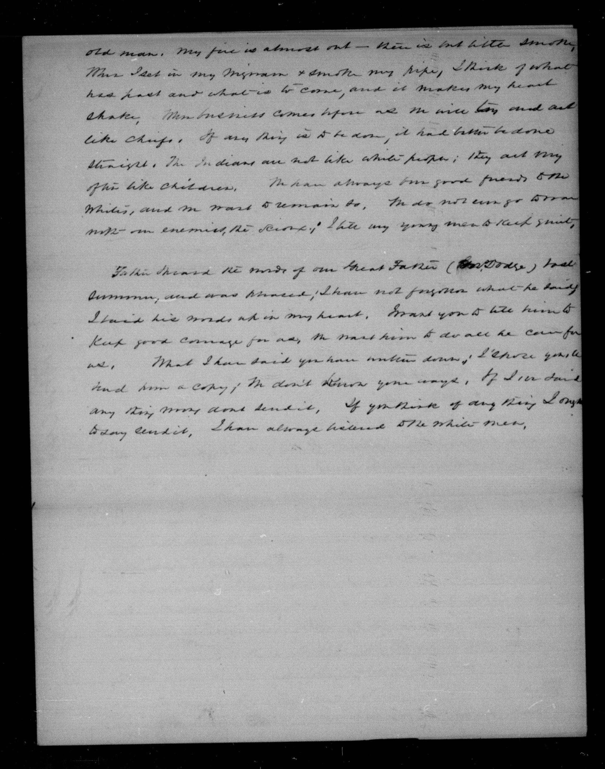
Father I speak for my people, not for myself. I am an old man. My fire is almost out – there is but little smoke. When I set in my wigwam & smoke my pipe, I think of what has past and what is to come, and it makes my heart shake. When business comes before us we will try and act like chiefs. If any thing is to be done, it had better be done straight. The Indians are not like white people; they act very often like children. We have always been good friends to the whites, and we want to remain so. We do not [even?] go to war with our enemies, the Sioux; I tell my young men to keep quiet.
Father I heard the words of our Great Father (Gov. Dodge) last summer, and was pleased; I have not forgotten what he said. I have his words up in my heart. I want you to tell him to keep good courage for us, we want him to do all he can for us. What I have said you have written down; I [?] you to hand him a copy; we don’t know your ways. If I [?] said any thing [?] dont send it. If you think of any thing I ought to say send it. I have always listened to the white men.
O.I.A. Lapointe, B.458
D. P. Bushnell
Lapointe, March 8, 1838
At the request of some of the petitioners, encloses a petition dated 7 March 1838, addressed to the Prest, signed by 167 Chip. half breeds, praying that the amt stipulated by the late Chip. Treaty to be paid to the half breeds, to satisfy all claims they ma have on the lands ceded by this Treaty, may be distributed at Lapointe.
Hopes their request will be complied with; & thinks their annuity should likewise be paid at Lapointe.
File
Recd 2nd May, 1838
Subagency
Lapointe Mch 6 1838
Sir
I have the honor herewith to enclose a petition addressed to the President of the United States, handed to me with a request by several of the petitioners that I would forward it. The justice of the demand of these poor people is so obvious to any one acquainted with their circumstances, that I cannot omit this occasion to second it, and to express a sincere hope that it will be complied with. Indeed, if the convenience and wishes of the Indians are consulted, and as the sum they receive for their country is so small, these should, I conciev, be principle considerations, their annuity will likewise as paid here; for it is a point more convenient of access for the different bands, that almost any other in their own country, and one moreover, where they have interests been in the habit of assembling in the summer months.
I am sir, with great respect,
your most obt servant,
D. P. Bushnell
O. I. A.
C. A. Harris Esqr.
Comr Ind. Affs
To the President of the United States of America
The humble petition of the undersigned Chippewa Half-Breeds citizens of the United States respectfully shareth
That your petitioners having lately heard, that a Treaty has been concluded between the Government of the United States and the Chippewa Indians at St Peters for the cession of certain lands belonging to that tribe;
That the said Chippewa Indians having a just regard to the interest and wellfare of their Half-Breed brethern, did there and then stipulate, that a certain sum of money should be paid once for all unto the said Half-Breeds, to satisfy all claims, they might have on the lands so ceded to the United States;
That your petitioners are ignorant of the time and place, where such payment is to be made; and
That the great majority of the Half-Breeds entitled to a portion of said sum of money are either residing at Lapointe on Lake Superior, or being for the most part earning their livelihood from the Traders, are consequently congregated during the summer months at the aforesaid place;
Your petitioners therefore humbly solicit their Father the President to take their case into consideration, and not subject them to a long and costly journey on ordering the payment to be made at any convenient distance, but on the contrary, they wish, that in his wisdom he will see the justice of this petition and that he will be pleased to order the same to be distributed at Lapointe agreeably to their request.
Your petitioners entertain the flattering hope, that their petition will not be made in vain and as in duly bound will ever pray.
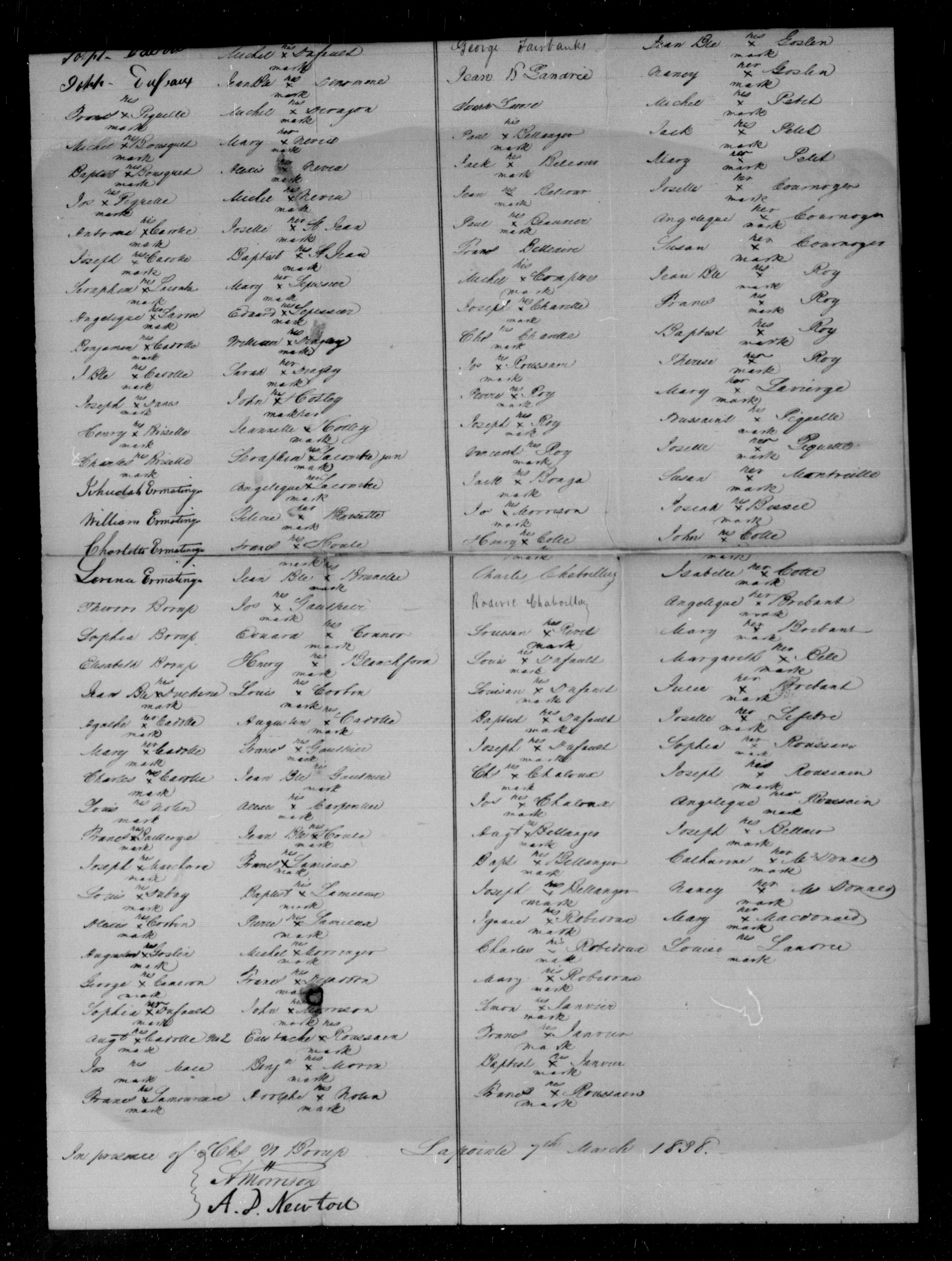
Half Breeds of Folleavoine Lapointe Lac Court Oreilles and Lac du Flambeau
Georg Warren
Edward Warren
William Warren
Truman A Warren
Mary Warren
Michel Cadott
Joseph Cadotte
Joseph Dufault
Frances Piquette X his mark
Michel Bousquet X his mark
Baptiste Bousquet X his mark
Jos Piquette X his mark
Antoine Cadotte X his mark
Joseph Cadotte X his mark
Seraphim Lacombre X his mark
Angelique Larose X her mark
Benjamin Cadotte X his mark
J Bte Cadotte X his mark
Joseph Danis X his mark
Henry Brisette X his mark
Charles Brisette X his mark
Jehudah Ermatinger
William Ermatinger
Charlotte Ermatinger
Larence Ermatinger
Theodore Borup
Sophia Borup
Elisabeth Borup
Jean Bte Duchene X his mark
Agathe Cadotte X her mark
Mary Cadotte X her mark
Charles Cadotte X his mark
Louis Nolin _ his mark
Frances Baillerge X his mark
Joseph Marchand X his mark
Louis Dubay X his mark
Alexis Corbin X his mark
Augustus Goslin X his mark
George Cameron X his mark
Sophia Dufault X her mark
Augt Cadotte No 2 X his mark
Jos Mace _ his mark
Frances Lamoureau X his mark
Charles Morrison
Charlotte L. Morrison
Mary A Morrison
Margerike Morrison
Jane Morrison
Julie Dufault X her mark
Michel Dufault X his mark
Jean Bte Denomme X his mark
Michel Deragon X his mark
Mary Neveu X her mark
Alexis Neveu X his mark
Michel Neveu X his mark
Josette St Jean X her mark
Baptist St Jean X his mark
Mary Lepessier X her mark
Edward Lepessier X his mark
William Dingley X his mark
Sarah Dingley X her mark
John Hotley X his mark
Jeannette Hotley X her mark
Seraphim Lacombre Jun X his mark
Angelique Lacombre X her mark
Felicia Brisette X her mark
Frances Houle X his mark
Jean Bte Brunelle X his mark
Jos Gauthier X his mark
Edward Connor X his mark
Henry Blanchford X his mark
Louis Corbin X his mark
Augustin Cadotte X his mark
Frances Gauthier X his mark
Jean Bte Gauthier X his mark
Alexis Carpentier X his mark
Jean Bte Houle X his mark
Frances Lamieux X his mark
Baptiste Lemieux X his mark
Pierre Lamieux X his mark
Michel Morringer X his mark
Frances Dejaddon X his mark
John Morrison X his mark
Eustache Roussain X his mark
Benjn Morin X his mark
Adolphe Nolin X his mark
Half-Breeds of Fond du Lac
John Aitken
Roger Aitken
Matilda Aitken
Harriet Aitken
Nancy Scott
Robert Fairbanks
George Fairbanks
Jean B Landrie
Joseph Larose
Paul Bellanges X his mark
Jack Belcour X his mark
Jean Belcour X his mark
Paul Beauvier X his mark
Frances Belleaire
Michel Comptois X his mark
Joseph Charette X his mark
Chl Charette X his mark
Jos Roussain X his mark
Pierre Roy X his mark
Joseph Roy X his mark
Vincent Roy X his mark
Jack Bonga X his mark
Jos Morrison X his mark
Henry Cotte X his mark
Charles Chaboillez
Roderic Chaboillez
Louison Rivet X his mark
Louis Dufault X his mark
Louison Dufault X his mark
Baptiste Dufault X his mark
Joseph Dufault X his mark
Chs Chaloux X his mark
Jos Chaloux X his mark
Augt Bellanger X his mark
Bapt Bellanger X his mark
Joseph Bellanger X his mark
Ignace Robidoux X his mark
Charles Robidoux X his mark
Mary Robidoux X her mark
Simon Janvier X his mark
Frances Janvier X his mark
Baptiste Janvier X his mark
Frances Roussain X his mark
Therese Rouleau X his mark
Joseph Lavierire X his mark
Susan Lapointe X her mark
Mary Lapointe X her mark
Louis Gordon X his mark
Antoine Gordon X his mark
Jean Bte Goslin X his mark
Nancy Goslin X her mark
Michel Petit X his mark
Jack Petit X his mark
Mary Petit X her mark
Josette Cournoyer X her mark
Angelique Cournoyer X her mark
Susan Cournoyer X her mark
Jean Bte Roy X his mark
Frances Roy X his mark
Baptist Roy X his mark
Therese Roy X her mark
Mary Lavierge X her mark
Toussaint Piquette X his mark
Josette Piquette X her mark
Susan Montreille X her mark
Josiah Bissel X his mark
John Cotte X his mark
Isabelle Cotte X her mark
Angelique Brebant X her mark
Mary Brebant X her mark
Margareth Bell X her mark
Julie Brebant X her mark
Josette Lefebre X her mark
Sophia Roussain X her mark
Joseph Roussain X his mark
Angelique Roussain X her mark
Joseph Bellair X his mark
Catharine McDonald X her mark
Nancy McDonald X her mark
Mary Macdonald X her mark
Louise Landrie X his mark
In presence of
Chs W Borup
A Morrison
A. D. Newton
Lapointe 7th March 1838
1827 Deed for Old La Pointe
December 27, 2022
Collected & edited by Amorin Mello
Chief Buffalo and other principal men for the La Pointe Bands of Lake Superior Chippewa began signing treaties with the United States at the 1825 Treaty of Prairie Du Chien; followed by the 1826 Treaty of Fond Du Lac, which reserved Tribal Trust Lands for Chippewa Mixed Bloods along the St. Mary’s River between Lake Superior and Lake Huron:
ARTICLE 4.
The Indian Trade & Intercourse Act of 1790 was the United States of America’s first law regulating tribal land interests:
SEC. 4. And be it enacted and declared, That no sale of lands made by any Indians, or any nation or tribe of Indians the United States, shall be valid to any person or persons, or to any state, whether having the right of pre-emption to such lands or not, unless the same shall be made and duly executed at some public treaty, held under the authority of the United States.
It being deemed important that the half-breeds, scattered through this extensive country, should be stimulated to exertion and improvement by the possession of permanent property and fixed residences, the Chippewa tribe, in consideration of the affection they bear to these persons, and of the interest which they feel in their welfare, grant to each of the persons described in the schedule hereunto annexed, being half-breeds and Chippewas by descent, and it being understood that the schedule includes all of this description who are attached to the Government of the United States, six hundred and forty acres of land, to be located, under the direction of the President of the United States, upon the islands and shore of the St. Mary’s river, wherever good land enough for this purpose can be found; and as soon as such locations are made, the jurisdiction and soil thereof are hereby ceded. It is the intention of the parties, that, where circumstances will permit, the grants be surveyed in the ancient French manner, bounding not less than six arpens, nor more than ten, upon the river, and running back for quantity; and that where this cannot be done, such grants be surveyed in any manner the President may direct. The locations for Oshauguscodaywayqua and her descendents shall be adjoining the lower part of the military reservation, and upon the head of Sugar Island. The persons to whom grants are made shall not have the privilege of conveying the same, without the permission of the President.
The aforementioned Schedule annexed to the 1826 Treaty of Fond du Lac included (among other Chippewa Mixed Blood families at La Pointe) the families of Madeline & Michel Cadotte, Sr. and their American son-in-laws, the brothers Truman A. Warren and Lyman M. Warren:
-
To Michael Cadotte, senior, son of Equawaice, one section.
-
To Equaysay way, wife of Michael Cadotte, senior, and to each of her children living within the United States, one section.
-
To each of the children of Charlotte Warren, widow of the late Truman A. Warren, one section.
-
To Ossinahjeeunoqua, wife of Michael Cadotte, Jr. and each of her children, one section.
-
To each of the children of Ugwudaushee, by the late Truman A. Warren, one section.
-
To William Warren, son of Lyman M. Warren, and Mary Cadotte, one section.

Detail of Michilimackinac County circa 1818 from Michigan as a territory 1805-1837 by C.A. Burkhart, 1926.
~ UW-Milwaukee Libraries
Now, if it seems odd for a Treaty in Minnesota (Fond du Lac) to give families in Wisconsin (La Pointe) lots of land in Michigan (Sault Ste Marie), just remember that these places were relatively ‘close’ to each other in the sociopolitical fabric of Michigan Territory back in 1827. All three places were in Michilimackinac County (seated at Michilimackinac) until 1826, when they were carved off together as part of the newly formed Chippewa County (seated at Sault Ste Marie). Lake Superior remained Unceded Territory until later decades when land cessions were negotiated in the 1836, 1837, 1842, and 1854 Treaties.
Ultimately, the United States removed the aforementioned Schedule from the 1826 Treaty before ratification in 1827.
Several months later, at Michilimackinac, Madeline & Michel Cadotte, Sr. recorded the following Deed to reserve 2,000 acres surrounding the old French Forts of La Pointe to benefit future generations of their family.
Register of Deeds
Michilimackinac County
Book A of Deeds, Pages 221-224

Michel Cadotte and
Magdalen Cadotte
to
Lyman M. Warren
~Deed.
Received for Record
July 26th 1827 at two Six O’Clock A.M.
J.P. King
Reg’r Probate

Bizhiki (Buffalo), Gimiwan (Rain), Kaubuzoway, Wyauweenind, and Bikwaakodowaanzige (Ball of Dye) signed the 1826 Treaty of Fond Du Lac as the Chief and principal men of La Pointe.

“Copy of 1834 map of La Pointe by Lyman M. Warren“ at Wisconsin Historical Society. Original map (not shown here) is in the American Fur Company papers of the New York Historical Society.
Whereas the Chief and principal men of the Chippeway Tribe of indians, residing on and in the parts adjacent to the island called Magdalen in the western part of Lake Superior, heretofore released and confirmed by Deed unto Magdalen Cadotte a Chippeway of the said tribe, and to her brothers and sisters as tenants in common, thereon, all that part of the said Island called Magdalen, lying south and west of a line commencing on the eastern shore of said Island in the outlet of Great Wing river, and running directly thence westerly to the centre of Sandy bay on the western side of said Island;
and whereas the said brothers and sisters of said Magdalen Cadotte being tenants in common of the said premises, thereafterwards, heretofore, released, conveyed and confirmed unto their sister, the said Magdalen Cadotte all their respective rights title, interest and claim in and to said premises,
and whereas the said Magdalen Cadotte is desirous of securing a portion of said premises to her five grand children viz; George Warren, Edward Warren and Nancy Warren children of her daughter Charlotte Warren, by Truman A. Warren late a trader at said island, deceased, and William Warren and Truman A. Warren children of her daughter Mary Warren by Lyman M. Warren now a trader at said Island;
and whereas the said Magdalen Cadotte is desirous to promote the establishment of a mission on said Island, by and under the direction, patronage and government of the American board of commissioners for foreign missions, according to the plan, wages, and principles and purposes of the said Board.

William Whipple Warren was one of the beneficiary grandchildren named in this Deed.
Now therefore, Know all men by these presents that we Michael Cadotte and Magdalen Cadotte, wife of the said Michael, of said Magdalen Island, in Lake Superior, for and in consideration of one dollar to us in hand paid by Lyman M. Warren, the receipt whereof is hereby acknowledged, and for and in consideration of the natural love and affection we bear to our Grandchildren, the said George, Edward, Nancy, William W., and Truman A. Warren, children of our said daughters Charlotte and Mary;
and the further consideration of our great desire to promote the establishment of a mission as aforesaid, under and by the direction, government and patronage of Board aforesaid, have granted, bargained, sold, released, conveyed and confirmed, and by these presents do grant, bargain, sell, release, convey and confirm unto the said Lyman M. Warren his heirs and assigns, out of the aforerecited premises and as part and parcel thereof a certain tract of land on Magdalen Island in Lake Superior, bounded as follows,
Detail of Ojibwemowin placenames on GLIFWC’s webmap.
that is to say, beginning at the most southeasterly corner of the house built and now occupied by said Lyman M. Warren, on the south shore of said Island between this tract and the land of the grantor, thence on the east by a line drawn northerly until it shall intersect at right angles a line drawn westerly from the mouth of Great Wing River to the Centre of Sandy Bay, thence on the north by the last mentioned line westward to a Point in said line, from which a line drawn southward and at right angles therewith would fall on the site of the old fort, so called on the southerly side of said Island; thence on the west by a line drawn from said point and parallel to the eastern boundary of said tract, to the Site of the old fort, so called, thence by the course of the Shore of old Fort Bay to the portage; thence by a line drawn eastwardly to the place of beginning, containing by estimation two thousand acres, be the same more or less, with the appurtenances, hereditaments, and privileges thereto belonging.
To have and to hold the said granted premises to him the said Lyman M. Warren his heirs and assigns: In Trust, Nevertheless, and upon this express condition, that whensoever the said American Board of Commissioners for foreign missions shall establish a mission on said premises, upon the plan, usages, principles and purposes as aforesaid, the said Lyman M. Warren shall forthwith convey unto the american board of commissioners for foreign missions, not less than one quarter nor more than one half of said tract herein conveyed to him, and to be divided by a line drawn from a point in the southern shore of said Island, northerly and parallel with the east line of said tract, and until it intersects the north line thereof.

Roughly 2,100 acres lies south of Middle Road.
And as to the residue of the said Estate, the said Lyman M. Warren shall divided the same equally with and amongst the said five children, as tenants in common, and not as joint tenants; and the grantors hereby authorize the said Lyman M. Warren with full powers to fulfil said trust herein created, hereby ratifying and confirming the deed and deeds of said premises he may make for the purpose ~~~
In witness whereof we have hereunto set our respective hands, this twenty fifth day of july A.D. one thousand eight hundred and twenty seven, of Independence the fifty first.
(Signed) Michel Cadotte {Seal}
Magdalen Cadotte X her mark {Seal}
Signed, Sealed and delivered
in presence of us }
Daniel Dingley
Samuel Ashman
Wm. M. Ferry
(on the third page and ninth line from the top the word eastwardly was interlined and from that word the three following lines and part of the fourth to the words “to the place” were erased before the signing & witnessing of this instrument.)
~~~~~~
Territory of Michigan }
County of Michilimackinac }
Be it known that on the twenty sixth day of July A.D. 1827, personally came before me, the subscriber, one of the Justices of the Peace for the County of Michilimackinac, Michel Cadotte and Magdalen Cadotte, wife of the said Michel Cadotte, and the said Magdalen being examined separate and apart from her said husband, each severally acknowledged the foregoing instrument to be their voluntary act and deed for the uses and purposes therein expressed.
(Signed) J. P. King
Just. peace
Cxd
fees Paid $2.25
“Considerable Altercation Ensued”
March 11, 2017
By Leo
Here is another gem from Wheeler. It appears to be a short description of a meeting in Odanah that quickly devolves into absurdity. It appears without any associated documents in the chronological professional papers of the Wheeler Family Collection at the Northern Great Lakes Visitor Center. For what it lacks in length and context, it makes up for in insight into the personalities of some prominent Chequamegon residents.
Odanah July 6, 1856
Council of Indians called by Mr Warren to make regulations in regard to the partitions of Domestic Arrivals & crops here. Mr S. C. Collins was appointed chairman & L. H. Wheeler Secretary.
Mr Warren presented some resolutions stating the object of the meeting , which was interpreted to the Indians.
After reading the paper Mr. Warren added remarks explaining the importance of some such regulations for the good of both the Whites & Indians.
After he stopped Blackbird spoke. The substance of his remarks was that the commissioner & agent told him to be still and do nothing till the agent should come, and therefore he should have nothing to do with what was proposed to them.
Out of contempt to Mr Warren he proposed that he should be made chief. He said it was treating them like children for Mr W to pass laws & rules for them to observe, just as though they were not able to take care of their own interests. He was asked more fully Mr Stoddard regarding the concluding remarks of Black Bird in substance, as a motion, to drop the whole subject, seconded the motion upon which considerable altercation ensued. The result of which was that the question should be considered still open for discussion and free remarks be allowed on both sides.
Odanah in 1856, just two years removed from the Treaty of 1854, was a community in flux. The cities of Ashland and Bayfield were growing rapidly with white American settlers. Being the largest of the newly-created reservations, Bad River was also growing as some of the Ojibwe bands from the Island, Ontonagon, St. Croix and the Chippewa River relocated there. In contrast to the Buffalo Bay (Red Cliff) reservation whose population included numerous mix-blood and Catholic families, the people of Bad River were largely full-bloods practicing traditional ways.
A handful of mix-blood and white families did live in Odanah, sponsored by the US Government and eastern missionary societies for Christianizing and “civilizing” the Ojibwe. These included the families of Reverend Leonard H. Wheeler founder of the Odanah mission, Truman A. Warren the government farmer, and John Stoddard the government carpenter. At this point in history, each of these men had lived in or around Odanah for several years and were well-known to area residents.

Truman A. Warren, brother of William W. Warren (Wisconsin Historical Society).
From the document, it appears that Warren called a meeting to create rules for the distribution of crops and goods to the Bad River Band. Warren was born at La Pointe in the mid-1820s to fur-trader Lyman Warren and Marie Cadotte Warren. Most Ojibwe men of the era avoided farming as it was considered women’s work. Warren, however, did not appear to share this view. He was a Christian mix-blood whose grandfather, Michel Cadotte, planted numerous crops on the Island. As a teenager, Truman, spent several years at school in New York learning English and doing farm labor.
Getting the farmer position, which had been created by the Treaty of 1842, was seen as a stroke of good fortune. His sister, Julia Warren Spears later described it as such:
My brother Truman A. Warren was the government farmer for the Indians, who lived at Bad River about 15 miles on the main land from La Pointe. That is where they made there garden and what other farming they did. The government farmer, carpenter, and blacksmith all had good houses to live in and received good salaries. (Spears to Bartlett; October 26, 1924)

Leonard H. Wheeler (Wisconsin Historical Society)
S. C. Collins is listed as the chairman of the meeting. I have been unable to find any other information about his connection to this area. I suspect he may have been a visitor or brief resident enlisted by Leonard Wheeler as a neutral party to conduct the meeting.
The Wheelers and Warrens were very close. Truman’s father was the original force behind bringing the Protestant missions into the area and Leonard and Harriet Wheeler helped raise Truman’s younger sister.
John Stoddard, the government carpenter has been identified by Amorin Mello as the most likely author of the mystery journal found in the Wheeler Collection. He was also close to Wheeler. As was Blackbird, the most prominent chief of the Bad River Ojibwe.
I’ve written before on how Blackbird and Wheeler were an odd couple. Wheeler was dedicated to the destruction of Ojibwe culture while Blackbird was perhaps the strongest advocate for maintaining traditional ways. Even so, the primary sources seem to indicate the men had a strong respect for one another.
Blackbird’s affections for Wheeler, however, don’t appear to extend to Warren. This isn’t overly surprising. Truman, and his deceased brother William, had run counter to the chief’s wishes on multiple occasions. William Warren criticized Blackbird directly at the time of the Martell Delegation. Blackbird also wanted to limit the power of Henry Rice’s “Indian Ring,” which employed numerous La Pointe mix-bloods including the Warrens.
In Theresa Schenck’s excellent William W. Warren: The Life, Letters, and Times of an Ojibwe Leader, the Warrens occasionally betray a paternalistic attitude toward their Ojibwe relatives. For example, William and Truman both initially supported the tragic Sandy Lake Removal of 1850-51 even though the Ojibwe leadership was rightfully opposed to it. Blackbird, of all the chiefs, seemed the least willing to accept condescension and threats to tribal sovereignty so it’s not surprising that a “considerable altercation ensued.”
For Wheeler’s part, I haven’t found any evidence he tried to force Robert’s Rules of Order on this area again.
Davidson, John N. In Unnamed Wisconsin. N.p.: Nabu, 2010. Print.
Paap, Howard D. Red Cliff, Wisconsin: A History of an Ojibwe Community. St. Cloud, MN: North Star of St. Cloud, 2013. Print.
Schenck, Theresa M. William W. Warren: The Life, Letters, and times of an Ojibwe Leader. Lincoln, Neb.: U of Nebraska, 2009. Print.
The Story of Chequamegon Bay
March 1, 2016
By Amorin Mello
This is a reproduction of Reuben Gold Thwaites’ 1895 “The Story of Chequamegon Bay” to demonstrate how our local history has been institutionalized and portrayed since the end of the 19th century. Thwaites’ professional legacy as a journalist is embedded in many institutions, including the following:
- American Library Association
- American Antiquarian Society
- University of Wisconsin
- Wisconsin State Journal
- Wisconsin Historical Society
- Mississippi Valley Historical Association
According to Wikipedia:
Thwaites was well-known for not being a mere academic, but rather as a historian who attempted to understand history by experiencing those aspects that he could, and bringing those experiences to life. In 1888 he took canoe trips on the Wisconsin, Fox and Rock rivers. In 1892 he took a bicycle trip across England. In 1903 he took a trip down the Ohio River in a rowboat.
Thwaites’ approach and work has been questioned, to some degree by his contemporaries but more so in modern times. His summaries include phraseology such as “[Europeans] left the most luxurious country in Europe to seek shelter in the foul and unwelcome huts of one of the most wretched races of man.” When editing the Jesuit Relations, he included background information that is generally credible and thorough with respect to events and Europe, but is far less thorough in regard to the disruptions from disease and other sources that the indigenous people themselves were facing. In other words, the criticism is that the original works were insensitive, and Thwaites failed to fully account for the prejudicial and inaccurate reporting in the Relations. However, Thwaites is also recognized as being the pioneer in an approach to using the Relations that is continuing to be enriched by modern scholarship, and so in a sense he started a process by which his very work could be corrected and improved as historians learn more about the periods in question.
The purpose of reproducing this story is to serve as an introduction to Chequamegon Bay history, and as a reference point for modern scholarship and primary research about Chequamegon Bay before 1860.
The Story about Chequamegon Bay was originally published in Collections of the State Historical Society of Wisconsin: Volume XIII, by Reuben Gold Thwaites, 1895, pages 397-425.
The Story Of Chequamegon Bay.
by the Editor.

Reuben Gold Thwaites
~ Wisconsin Historical Society
WE commonly think of Wisconsin as a young State. In a certain sense she is. There are men now living, two or three of whom I meet almost daily, who were blazing paths through the Wisconsin wilderness, only sixty years ago: men who cleared the forests and broke the prairies; who founded frontier communities which have developed into cities; who upon this far away border sowed the seeds of industries which to-day support tens of thousands of their fellows; who threw up their hats when the Territory was erected; and who sat in the convention which gave to the new State a constitution. The Wisconsin of to-day, the Wisconsin which we know, is indeed young; for the lively octogenarians who were in at the birth will not admit that they are now old. But there was an earlier, a less prosaic, a far more romantic Wisconsin,—the French Wisconsin; and it had flourished in its own fashion for full two centuries before the coming of the Anglo-Saxon, who, brusquely crowding the Creole to the wall, made of his old home an American Commonwealth.
In 1634, when the child born upon the Mayflower was but in her fourteenth year, Jean Nicolet, sent out by the enterprising Champlain as far as Wisconsin,— a thousand miles of canoe journey west from Quebec,— made trading contracts, such as they were, with a half-score of squalid tribes huddled in widely-separated villages throughout the broad wilderness lying between Lakes Superior and Michigan. It was a daring, laborious expedition, as notable in its day as Livingstone’s earliest exploits in Darkest Africa ; and although its results were slow of development,—for in the seventeenth century man was still cautiously deliberate,— this initial visit of the forest ambassador of New France to the country of the Upper Lakes broke the path for a train of events which were of mighty significance in American history.1

“Jean Nicolet, landing at the Bay of Green Bay in 1634. Painted by Franz Edward Rohrbeck (1852-1919) in 1910 into the mural in the rotunda of the Brown County Courthouse, Green Bay, Wisconsin. It shows Nicolet wearing a Chinese damask tunic strewn with flowers and birds, and discharging two pistols into the air.”
~ Wikipedia.org
Let us examine the topography of Wisconsin. The State is situated at the head of the chain of Great Lakes. It is touched on the east by Lake Michigan, on the north by Lake Superior, on the west by the Mississippi, and is drained by interlacing rivers which so closely approach each other that the canoe voyager can with case pass from one great water system to the other; he can enter the continent at the Gulf of St. Lawrence, and by means of numerous narrow portages in Wisconsin emerge into the south-flowing Mississippi, eventually returning to the Atlantic through the Gulf of Mexico. From Lake Michigan, the Fox-Wisconsin river system was the most popular highway to the great river; into Lake Superior, there flow numerous turbulent streams from whose sources lead short portage trails over to the headwaters .of feeders of the Mississippi. From the western shore of Lake Superior, Pigeon River invites to exploration of the Winnipeg country, whence the canoeist can by a half-hundred easy routes reach the distant regions of Athabasca and the Polar Sea. In their early voyages to the head of lake navigation, it was in the course of nature that the French should soon discover Wisconsin; and having discovered it, learn that it was the key-point of the Northwest — the gateway to the entire continental interior. Thus, through Wisconsin’s remarkable system of interlacing waterways, to which Nicolet led the way, New France largely prosecuted her far-reaching forest trade and her missionary explorations, securing a nominal control of the basin of the Mississippi at a time when Anglo-Saxons had gained little more of the Atlantic slope than could be seen from the mast-head of a caravel. Thus the geographical character of Wisconsin became, early in the history of New France, an important factor. The trading posts and Jesuit missions on Chequamegon Bay2 of Lake Superior, and on Green Bay of Lake Michigan, soon played a prominent part in American exploration. The career of Green Bay is familiar to us all.3 I have thought it well hastily to summarize, in the brief space allowed me, the equally instructive story of Chequamegon Bay.

“Outline Map showing the position of the ancient mine-pits of Point Keweenaw, Michigan”
~ Ancient Mining on the Shores of Lake Superior, by Charles Whittlesey
The sandstone cliffs of Lake Superior were, many geologists think, among the first Laurentian islands to arise from the ancient ocean; if this be so, then the rim of our greatest inland sea is one of the oldest spots on earth. In its numerous mines of copper, prehistoric man long delved and wrought with rude hammers and chisels of stone, fashioning those curious copper implements which are carefully treasured in American museums of archaeology;4 and upon its rugged shores the Caucasian early planted his stake, when between him and New England tidewater all was savagery.
Pierre d’Esprit Sieur Radisson
~ Dictionary of Canadian Biography
After the coming to Wisconsin of Nicolet, a long period followed, in which the energies of New France were devoted to fighting back the Iroquois, who swarmed before the very gates of Quebec and Montreal. Exploration was for the time impossible. A quarter of a century passes away before we have evidence of another white man upon Wisconsin soil. In the spring of 1659, the Indians of the valley of the Fox were visited by two French fur-traders from the Lower St. Lawrence – Pierre d’Esprit, Sieur Radisson, and his sister’s husband, Medard Chouart, Sieur de Groseilliers. In all American history there are no characters more picturesque than these two adventurous Creoles, who, in their fond desire to “travell and see countries,” and “to be known as the remotest people,” roamed at will over the broad region between St. Jame’s seaway and the Wisconsin River, having many curious experiences with wild beasts and wilder men. They made several important geographical discoveries, – among them, probably, the discovery of the Mississippi River in 1659, fourteen years before the visit of Joliet and Marquette; and from a trading settlement proposed by them to the English, when their fellow-countrymen no longer gave them employment, developed the great establishment of the Hudson’s Bay Company. The unconsciously-amusing narrative which Radisson afterwards wrote, for the editication of King Charles II, of England, is one of the most interesting known to American antiquaries.5

“Arrival of Radisson in an Indian camp, 1660”
by Charles William Jefferys
~ Wikimedia.org
Two years after Radisson and Groseilliers were upon the Fox River, and made their notable trip to the Mississippi, they were again in the Northwest (autumn of 1661), and this time upon Lake Superior, which they had approached by carrying around the Sault Ste. Marie. Skirting the southern shore of the lake, past the now famous Pictured Rocks, they carried across Keweenaw Point, visited a band of Christino Indians6 not far from the mouth of Montreal River, now the far western boundary between Upper Michigan and Wisconsin, and, portaging across the base of the Chequamegon Island of to-day, – then united to the mainland,- entered beautiful Chequamegon Bay. Just where they made their camp, it is impossible from Radisson’s confused narrative to say; but that it was upon the mainland no Wisconsin antiquary now doubts, and we have reason to believe that it was upon the southwest shore, between the modern towns of Ashland and Washburn.7

“Close-up of the Radisson and Groseilliers house historic site marker, commemorating the first house built in Wisconsin by white men. The house was believed to have stood in the vicinity of Ashland at the mouth of Fish Creek where it empties into Chequamegon Bay.”
~ Wisconsin Historical Society
Our chronicler writes, with a particularity of detail suggestive of De Foe:
“We went about to make a fort of stakes, w’ was in this manner. Suppose that the watter-side had ben in one end; att the same end there should be murtherers, and att need we made a bastion in a triangle to defend us from assault. The doore was neare the watter side, our fire was in the midle, and our bed on the right hand, covered. There were boughs of trees all about our fort layed acrosse, one uppon an other. Besides those boughs, we had a long cord tyed w’ some small bells, w’ weare sentereys. Finally, we made an ende of that fort in 2 dayes’ time.”
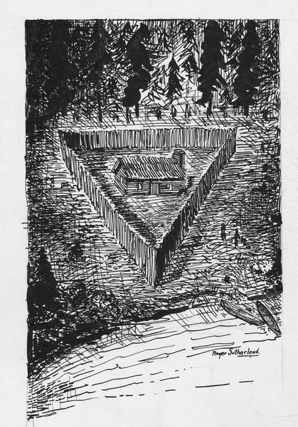
“Front view of the Radisson cabin, the first house built by a white man in Wisconsin. It was built between 1650 and 1660 on Chequamegon Bay, in the vicinity of Ashland. This drawing is not necessarily historically accurate.”
~ Wisconsin Historical Society
Modernize this statement, and in imagination we can see this first dwelling erected by man on the shores of Lake Superior; a small log hut, built possibly on the extremity of a small rocky promontory; the door opens to the water front, while the land side, to the rear of the hut, is defended by a salient of palisades stretching from bank to bank of the narrow promontory; all about the rude structure is a wall of pine boughs piled one upon the other, with a long cord intertwined, and on this cord are strung numbers of the little hawk-bells then largely used in the Indian trade for purposes of gift and barter. It was expected that in case of a night attack from savages, who might be willing to kill them for the sake of their stores, the enemy would stir the boughs and unwittingly ring the bells, thus arousing the little garrison. These ingenious defenses were not put to the test, although no doubt they had a good moral effect; in keeping the thieving Hurons at a respectful distance.
Winter was just setting in. The waters of the noble bay were taking on that black and sullen aspect peculiar to the season. The beautiful islands, later named for the Twelve Apostles,8 looked gloomy indeed in their dark evergreen mantles. From the precipitous edges of the red-sandstone cliffs, which girt about this estuary of our greatest inland sea, the dense pine forests stretched westward and southward for hundreds of miles. Here and there in the primeval depths was a cluster of starveling Algonkins, still trembling from fear of a return of the Iroquois, who had chased them from Canada into this land of swamps and tangled woods, where their safety lay in hiding. At wide intervals, uncertain trails led from village to village, and in places the rivers were convenient highways; these narrow paths, however, beset with danger in a thousand shapes, but emphasized the unspeakable terrors of the wilderness.
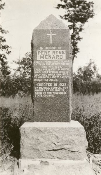
Père René Ménard
“The Search for Wisconsin’s First Priest”
~ Wisconsin Historical Society
Radisson and Groseilliers, true coureurs de bois, were not daunted by the dangers which daily beset them. After caching their goods, they passed the winter of 1661-62 with their Huron neighbors, upon a prolonged hunt, far into the Mille Lacs region of Minnesota. The season was phenomenally severe, and the Indians could not find game enough to sustain life. A famine ensued in the camp, the tragical details of which are painted by our friend Radisson with Hogarthian minuteness. In the spring of 1662, the traders were back again at Chequamegon, and built another fortified shelter, this time possibly on the sand-spit of Shagawaumikong,9 from which base they once more wandered in search of adventures and peltries, going as far northwest as Lake Assiniboine, and later in the season returning to their home on the Lower St. Lawrence.
When Radisson’s party went to Lake Superior, in the autumn of 1661, they were accompanied as far as Keweenaw Bay by a Jesuit priest. Father Pierre Ménard, who established there a mission among the Ottawas. The following June, disheartened in his attempt to convert these obdurate tribesmen, Ménard set out for the Huron villages on the upper waters of the Black and Chippewa, but perished on the way.10
It was not until August of 1665, three years later, that Father Claude Allouez, another Jesuit, was sent to reopen the abandoned Ottawa mission on Lake Superior. He chose his site on the southwestern shore of Chequamegon Bay, possibly the same spot on which Radisson’s hut had been built, four years previous, and piously called his mission and the locality La Pointe du Saint Esprit, which in time was shortened to La Pointe.11

Detail of La Pointe du Saint Esprit
from Claude Allouez map’s of New France, 1669.
~ Research Laboratories of Archaeology

Portrayal of Claude Allouez
~ National Park Service
At the time of Radisson’s visit, the shores of Chequamegon Bay were uninhabited save by a few half-starved Hurons ; but soon thereafter it became the centre of a considerable Indian population, residents of several tribes having been drawn thither, first, by the fisheries, second, by a fancied security in so isolated a region against the Iroquois of the East and the wild Sioux of the West. When Allouez arrived in this polyglot village, October 1, he found there Chippewas, Pottawattómies, Kickapoos, Sauks, and Foxes, all of them Wisconsin tribes; besides these were Hurons, Ottawas, Miamis, and Illinois,— victims of Iroquois hate who had fled in droves before the westward advances of their merciless tormentors.

Jacques Marquette
aka James (Jim) or Père Marquette
~ Wikipedia
Despite his large congregations, Allouez made little headway among these people, being consoled for his hardships and ill-treatment by the devotion of a mere handful of followers. For four years did he labor alone in the Wisconsin wilderness, hoping against hope, varying the monotony of his dreary task by occasional canoe voyages to Quebec, to report progress to his father superior. Father James Marquette, a more youthful zealot, was at last sent to relieve him, and in September, 1669, arrived at La Pointe from Sault Ste. Marie, after spending a full month upon, the journey,—so hampered was he, at that early season, by snow and ice. Allouez, thus relieved from a work that had doubtless palled upon him, proceeded upon invitation of the Pottawattomies to Green Bay, where he arrived early in December, and founded the second Jesuit mission in Wisconsin, St. Francis Xavier, on the site of the modern town of Depere.12
Marquette had succeeded to an uncomfortable berth. Despite his strenuous efforts as a peacemaker, his dusky parishioners soon unwisely quarreled with their western neighbors, the Sioux,13 with the result that the La Pointe bands, and Marquette with them, were driven like leaves before an autumn blast eastward along the southern shore of the great lake: the Ottawas taking up their home in the Manitoulin Islands of Lake Huron, the Hurons accompanying Marquette to the Straits of Mackinaw, where he established the mission of St. Ignace.
With La Pointe mission abandoned, and Lake Superior closed to French enterprise by the “raging Sioux,” the mission at Depere now became the centre of Jesuit operations in Wisconsin, and it was a hundred and sixty-four years later (1835), before mass was again said upon the forest-fringed shores of Chequamegon Bay.
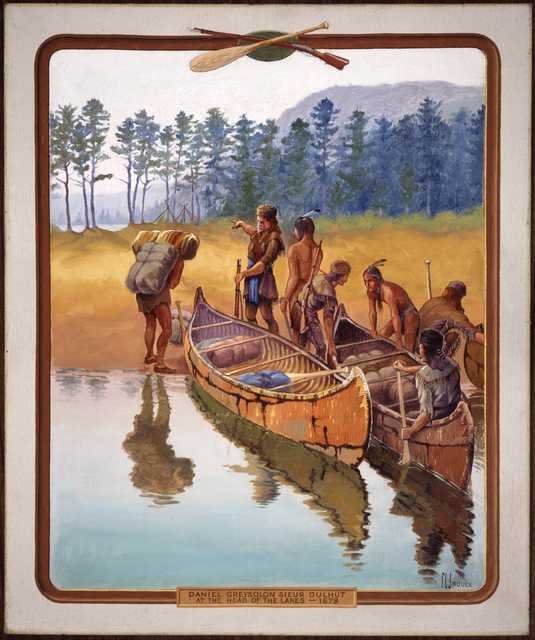
“‘Daniel Greysolon Sieur Dulhut at the Head of the Lakes – 1679.’ Painted by artist Francis Lee Jaques, c.1922.”
~ Minnesota Historical Society
Although the missionary had deserted La Pointe, the fur trader soon came to be much in evidence there. The spirit of Radisson and Groseilliers long permeated this out-of-the-way corner of the Northwest. We find (1673), three years after Marquette’s expulsion. La Salle’s trading agent, Sieur Raudin, cajoling the now relentent Sioux at the western end of Lake Superior. In the summer of 1679, that dashing coureur de bois, Daniel Grayson du l’ Hut,14 ascended the St. Louis River, which divides Wisconsin and Minnesota, and penetrated with his lively crew of voyageurs to the Sandy Lake country, being probably the first white trader upon the head-waters of the Mississippi. The succeeding winter, he spent in profitable commerce with the Assiniboines, Crees, and other northern tribes in the neighborhood of Grand Portage,15 on the boundary between Minnesota and Canada. In June, 1680, probably unaware of the easier portage by way of the Mille Lacs and Rum River, Du I’ Hut set out at the head of a small company of employees to reach the Mississippi by a new route. Entering the narrow and turbulent Bois Brulé,16 half-way along the southern shore of Lake Superior, between Red Cliff and St. Louis River, he with difficulty made his way over the fallen trees and beaver dams which then choked its course. From its head waters there is a mile-long portage to the upper St. Croix; this traversed. Du l’ Hut was upon a romantic stream which swiftly carried him, through foaming rapids and deep, cool lakes, down into the Father of Waters. Here it was that he heard of Father Louis Hennepin’s captivity among the Sioux, and with much address and some courage rescued that doughty adventurer, and carried him by way of the Fox-Wisconsin route in safety to Mackinaw.
…
“In 1693, Le Sueur founded a trading post on the site of present-day La Pointe on Madeline Island, the largest of Chequamegon Bay’s Apostle Islands. After hearing reports of what he believed were valuable deposits of copper ore south of Lake Superior, he traveled to France in 1697, where the French government granted him permission to mine these resources.”
~ Encyclopedia of Exploration, vol. 1, 2004.
An adventurous forest trader, named Le Sueur, was the next man to imprint his name on the page of Lake Superior history. The Fox Indians, who controlled the valleys of the Fox and Wisconsin Rivers, had for various reasons become so hostile to the French that those divergent streams were no longer safe as a gateway from the Great Lakes to the Great River. The tendency of the prolonged Fox War was to force fur trade travel to the portages of Chicago and St. Joseph’s on the south, and those of Lake Superior on the north.17 It was with a view to keeping open one of Du l’ Hut’s old routes, – the Bois Brulé and St. Croix Rivers,- that Le Sueur was despatched by the authorities of New France in 1693. He built a stockaded fort on Madelaine island, convenient for guarding the northern approach,18 and another on an island in the Mississippi, below the mouth of the St. Croix, and near the present town of Red Wing, Minnesota. The post in the Mississippi soon became “the centre of commerce for the Western parts”; and the station in Chequamegon Bay also soon rose to importance, for the Chippewas, who had drifted far inland into Wisconsin and Minnesota with the growing scarcity of game,- the natural result of the indiscriminate slaughter which the fur trade encouraged, – were induced by the new trading facilities to return to their old bay shore haunts, massing themselves in an important village on the southwestern shore.
This incident strikingly illustrates the important part which the trader early came to play in Indian life. At first an agriculturalist in a small way, and a hunter and fisher only so far as the daily necessities of food and clothing required, the Indian was induced by the white man to kill animals for their furs, – luxuries ever in great demand in the marts of civilization. The savage wholly devoted himself to the chase, and it became necessary for the white man to supply him with clothing, tools, weapons, and ornaments of European manufacture; the currency as well as the necessities of the wilderness.19 These articles the savage had heretofore laboriously fashioned for himself at great expenditure of time; no longer was he content with native manufactures, and indeed he quickly lost his old-time facility for making them. It was not long before he was almost wholly dependent on the white trader for the commonest conveniences of life; no longer being tied to his fields, he became more and more a nomad, roving restlessly to and fro in search of fur-bearing game, and quickly populating or depopulating a district according to the conditions of trade. Without his trader, he quickly sank into misery and despair; with the advent of the trader, a certain sort of prosperity once more reigned in the tepee of the red man. In the story of Chequamegon Bay, the heroes are the fur trader and the missionary; and of these the fur trader is the greater, for without his presence on this scene there would have been no Indians to convert.
~ State of Wisconsin Blue Book, 1925, page 66.
Although Le Sueur was not many years in command upon Chequamegon Bay,20 we catch frequent glimpses thereafter of stockaded fur trade stations here, – French, English, and American, in turn, – the most of them doubtless being on Madelaine Island, which was easily defensible from the mainland.21 We know that in 1717 there was a French trader at La Pointe – the popular name for the entire bay district—for he was asked by Lt. Robertel de la Noüe, who was then at Kaministiquoya, to forward a letter to a certain Sioux chief. In September, 1718, Captain Paul Legardeur St. Pierre, whose mother was a daughter of Jean Nicolet, Wisconsin’s first explorer, was sent to command at Chequamegon, assisted by Ensign Linctot, the authorities of the lower country having been informed that the Chippewa chief there was, with his fellow-chief at Keweenaw, going to war with the Foxes. St. Pierre was at Chequamegon for at least a year, and was succeeded by Linctot, who effected an important peace between the Chippewas and Sioux.22
The Indians at La Pointe told the French of an island of copper guarded by spirits; La Ronde, when he heard of the mineral, requested permission from the French Government to combine his duties at the fort with mining. he was not given permission to operate the mines until 1733, and in 1740 his mining activities were halted by an outbreak between the Sioux and the Chippewa. Nonetheless, La Ronde is known as the first practical miner on Lake Superior, and the man who opened this region for settlement by white men.”
~ The WPA Guide to Wisconsin, by Federal Writers’ Project, 2013, page 348.
~ Dictionary of Canadian Biography
Whether a garrisoned fort was maintained at Chequamegon Bay, from St. Pierre’s time to the close of the French domination, it is impossible to say; but it seems probable; for the geographical position was one of great importance in the development of the fur trade, and the few records we have mention the fort as one of long standing.23 In 1730, it is recorded, that a nugget of copper was brought to the post by an Indian, and search was at once made for a mine; but October 18, 1731, the authorities of New France wrote to the home office in Paris that, owing to the superstitions of the Indians, which led them to conceal mineral wealth from the whites, no copper mine had thus far been found in the neighborhood of Chequamegon Bay. The commandant of Chequamegon at this time was Sieur La Ronde Denis, known to history as La Ronde,— like his predecessors, for the most part, a considerable trader in these far Western parts, and necessarily a man of enterprise and vigor. La Ronde was for many years the chief trader in the Lake Superior country, his son and partner being Denis de La Ronde. They built for their trade a boat of 40 tons, which was without doubt “the first vessel on the great lake, with sails larger than an Indian blanket.” 24 On account of the great outlay they had incurred in this and other undertakings in the wilderness, the post of Chequamegon, with its trading monopoly, had been given to the elder La Ronde, according to a despatch of that day, “as a gratuity to defray expenses.” Other allusions to the La Rondes are not infrequent: in 1736,25 the son is ordered to investigate a report of a copper mine at Iron River, not far east of the Bois Brulé; in the spring of 1740, the father is at Mackinaw on his return to Chequamegon from a visit to the lower country, but being sick is obliged to return to Montreal;26 and in 1744, Bellin’s map gives the name “Isle de la Ronde” to what we now know as Madelaine, fair evidence that the French post of this period was on that island.

Detail of Isle de la Ronde from Carte des lacs du Canada by Jacques-Nicolas Bellin, 1744.
~ Wisconsin Historical Society
Pierre-Joseph was the son of Joseph Hertel de St.Francois & Catherine Philippe, born in Trois-Rivieres. He married Catherine-Madeleine Jarrot (daughter of Jean Bte.Jarrot, sieur de Vercheres & Madeleine Francoise d’Ailleboust de Manthet) in 1751. [Her father commanded the post at Green Bay in 1747].
Pierre-Joseph followed in his families tradition and was a captain on a raid of Albany in 1756 during the King George’s War. From 1756 to 1758 he was commander of the post of Lapointe (in today’s northern Wisconsin) and sailed for France after the loss of Canada to the British.”
~ [Unknown].
We hear nothing more of importance concerning Chequamegon until about 1756, when Hertel de Beaubassin, the last French commandant there, was summoned to Lower Canada with his Chippewa allies, to do battle against the English.27 For several years past, wandering English fur traders had been tampering with the Chippewas of Lake Superior, who in consequence frequently maltreated their old friends, the French;28 but now that the tribe were summoned for actual fighting in the lower country, with extravagant promises of presents, booty, and scalps, they with other Wisconsin Indians eagerly flocked under the French banner, and in painted swarms appeared on the banks of the St. Lawrence, with no better result than to embarrass the French commissariat and thus unwittingly aid the ambitious English.
New France was tottering to her fall. The little garrison on Madelaine Island had been withdrawn from the frontier, with many another like it, to help in the defense of the lower country ; and the Upper Lakes, no longer policed by the fur trade monopoly, were free plunder for unlicensed traders, or coureurs des bois. Doubtless such were the party who encamped upon the island during the autumn of 1760. By the time winter had set in upon them, all had left for their wintering grounds in the forests of the far West and Northwest, save a clerk named Joseph, who remained in charge of the stores and the local traffic. With him were his little family,—his wife, who was from Montreal, his child, a small boy, and a man-servant, or voyageur. Traditions differ as to the cause of the servant’s action,— some have it, a desire for wholesale plunder; others, the being detected in a series of petty thefts, which Joseph threatened to report; others, an unholy and unrequited passion for Joseph’s wife. However that may be, the servant murdered first the clerk, and then the wife; and in a few days, stung by the piteous cries of the child, the lad himself. When the spring came, and the traders returned to Chequamegon, they inquired for Joseph and his family, but the servant’s reply was unsatisfactory and he finally confessed to his horrid deed. The story goes, that in horror the traders dismantled the old French fort as a thing accursed, sunk the cannon in a neighboring pool, and so destroyed the palisade that to-day naught remains save grassy mounds. Carrying their prisoner with them on their return voyage to Montreal, he is said to have escaped to the Hurons, among whom he boasted of his deed, only to be killed as too cruel a companion even for savages.29

Detail of “The 12 Apostles” from Captain Jonathan Carver’s journal of his travels with maps and drawings, 1769. ~ Boston Public Library

Alexander Henry , The Elder.
~ Wikipedia.com
New France having now fallen, an English trader, Alexander Henry, spent the winter of 1765-66 upon the mainland, opposite the island.30 Henry had obtained from the English commandant at Mackinaw the exclusive trade of Lake Superior, and at Sault Ste. Marie took into partnership with him Jean Baptiste Cadotte,31 a thrifty Frenchman, who for many years thereafter was one of the most prominent characters on the Upper Lakes. Henry and Cadotte spent several winters together on Lake Superior, but only one upon the shores of Chequamegon, which Henry styles “the metropolis of the Chippeways.”32

John Johnston
~ Homestead.org
The next dweller at Chequamegon Bay, of whom, we have record, was John Johnston, a Scotch-Irish fur trader of some education. Johnston established himself on Madelaine Island, not far from the site of the old French fort; some four miles across the water, on the mainland to the west, near where is now the white town of Bayfield, was a Chippewa village with whose inhabitants he engaged in traffic. Waubojeeg (White Fisher), a forest celebrity in his day, was the village chief at this time, and possessed of a comely daughter whom Johnston soon sought and obtained in marriage. Taking his bride to his island home, Johnston appears to have lived there for a year or two in friendly commerce with the natives, at last retiring to his old station at Sault Ste. Marie.33
Mention has been made of Jean Baptiste Cadotte, who was a partner of Alexander Henry in the latter’s Lake Superior trade, soon after the middle of the century. Cadotte, whose wife was a Chippewa, after his venture with Henry had returned to Sault Ste. Marie, from which point he conducted an extensive trade through the Northwest. Burdened with advancing years, he retired from the traffic in 1796, and divided the business between his two sons, Jean Baptiste and Michel.

Michel Cadotte
~ Findagrave.com
About the opening of the present century,34 Michel took up his abode on Madelaine Island, and from that time to the present there has been a continuous settlement upon it. He had been educated at Montreal, and marrying Equaysayway, the daughter of White Crane, the village chief of La Pointe,35 at once became a person of much importance in the Lake Superior country. Upon the old trading site at the southwestern corner of the island, by this time commonly called La Pointe,— borrowing the name, as we have seen, from the original La Pointe, on the mainland, and it in turn from Point Chequamegon,—Cadotte for over a quarter of a century lived at his ease; here he cultivated a “comfortable little farm,” commanded a fluctuating, but often far-reaching fur trade, first as agent of the Northwest Company and later of Astor’s American Fur Company, and reared a considerable family, the sons of which were, as he had been, educated at Montreal, and became the heads of families of Creole traders, interpreters, and voyageurs whom antiquarians now eagerly seek when engaged in bringing to light the French and Indian traditions of Lake Superior.36
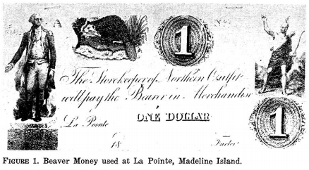
La Pointe Beaver Money
Northern Outfit, American Fur Company
~ Wisconsin Academy of Science, Arts, & Letters, volume 54, page 159.
In the year 1818 there came to the Lake Superior country two sturdy, fairly-educated37 young men, natives of the Berkshire hills of Massachusetts,—Lyman Marcus Warren, and his younger brother, Truman Abraham. They were of the purest New England stock, being lineally descended from Richard Warren, one of the “Mayflower” company. Engaging in the fur trade, the brothers soon became popular with the Chippewas, and in 1821 still further entrenched themselves in the affections of the tribesmen by marrying the two half-breed daughters of old Michel Cadotte,—Lyman taking unto himself Mary, while Charlotte became the wife of Truman. At first the Warrens worked in opposition to the American Fur Company, but John Jacob Astor’s lieutenants were shrewd men and understood the art of overcoming commercial rivals. Lyman was made by them a partner in the lake traffic, and in 1824 established himself at-La Pointe as the company’s agent for the Lac Flambeau, Lac Courte Oreille, and St. Croix departments, an arrangement which continued for some fourteen years. The year previous, the brothers had bought out the interests of their father-in-law, who now, much reduced in means, retired to private life after forty years’ prosecution of the forest trade.38

American Fur Company “Map of La Pointe”
by Lyman Marcus Warren, 1834.
~ Wisconsin Historical Society
The brothers Warren were the last of the great La Pointe fur traders.39 Truman passed away early in his career, having expired in 1825, while upon a voyage between Mackinaw and Detroit. Lyman lived at La Pointe until 1838, when his connection with the American Fur Company was dissolved, and then became United States sub-agent to the Chippewa reservation on Chippewa River, where he died on the tenth of October, 1847, aged fifty-three years.40

Iu Otoshki-Kikindiuin Au Tebeniminvng Gaie Bemajiinung Jesus Christ, Ima Ojibue Inueuining Giizhitong:
The New Testament of Our Lord and Saviour Jesus Christ
by Sherman Hall and Henry Blatchford, 1856.
~ Archive.org
Lyman Marcus Warren was a Presbyterian, and, although possessed of a Catholic wife, was the first to invite Protestant missionaries to Lake. Superior. Not since the days of Allouez had there been an ordained minister at La Pointe; Warren was solicitous for the spiritual welfare of his Chippewa friends, especially the young, who were being reared without religious instruction, and subject to the demoralizing influence of a rough element of white borderers. The Catholic Church was not just then ready to reenter the long-neglected field; his predilections, too, were for the Protestant faith. In 1830, while upon his annual summer trip to Mackinaw for supplies, be secured the cooperation of Frederick Ayer, of the Mackinaw mission, who returned with him in his batteau as lay preacher and school-teacher, and opened at La Pointe what was then the only mission upon the shores of the great lake. Thither came in Warren’s company, the latter part of August, the following year (1831), Rev. Sherman Hall and wife, who served as missionary and teacher, respectively, and Mrs. John Campbell, an interpreter.41
La Pointe was then upon the site of the old French trading post at the southwest corner of Madelaine Island; and there, on the first Sunday afternoon after his arrival, Mr. Hall preached “the first sermon ever delivered in this place by a regularly-ordained Christian minister.” The missionaries appear to have been kindly received by the Catholic Creoles, several of whom were now domiciled at La Pointe. The school was patronized by most of the families upon the island, red and white, who had children of proper age. By the first of September there was an average attendance of twenty-five. Instruction was given almost wholly in the English language, with regular Sunday-school exercises for the children, and frequent gospel meetings for the Indian and Creole adults.
We have seen that the first La Pointe village was at the southwestern extremity of the island. This was known as the “Old Fort” site, for here had been the original Chippewa village, and later the fur-trading posts of the French and English. Gradually, the old harbor became shallow, because of the shifting sand, and unfit for the new and larger vessels which came to be used in the fur trade.

The American Fur Company therefore built a “New Fort” a few miles farther north, still upon the west shore of the island, and to this place, the present village, the name La Pointe came to be transferred. Half-way between the “Old fort” and the “New fort,” Mr. Hall erected (probably in 1832) “a place for worship and teaching,” which came to be the centre of Protestant missionary work in Chequamegon Bay.

Leonard Hemenway Wheeler
~ Unnamed Wisconsin by John Nelson Davidson, 1895.
At that time, the Presbyterians and Congregationalists were, in the American Home Missionary Society and the American Board, united in the conduct of Wisconsin missions, and it is difficult for a layman to understand to which denomination the institution of the original Protestant mission at La Pointe may properly be ascribed. Warren was, according to Neill, a Presbyterian, so also, nominally, were Ayer and Hall, although the last two were latterly rated as Congregationalists. Davidson, a Congregational authority, says: “The first organization of a Congregational church within the present limits of Wisconsin took place at La Pointe in August, 1833, in connection with this mission”;42 and certainly the missionaries who later came to assist Hall were of the Congregational faith; these were Rev. Leonard Hemenway Wheeler and wife, Rev. Woodbridge L. James and wife, and Miss Abigail Spooner. Their work appears to have been as successful as such proselyting endeavors among our American Indians can hope to be, and no doubt did much among the Wisconsin Chippewas to stem the tide of demoralization which upon the free advent of the whites overwhelmed so many of our Western tribes.
James’ family did not long remain at La Pointe. Wheeler was soon recognized as the leading spirit there, although Hail did useful service in the field of publication, his translation of the New Testament into Chippewa (completed in 1836) being among the earliest of Western books. Ayer eventually went to Minnesota. In May, 1845, owing to the removal of the majority of the La Pointe Indians to the new Odanah mission, on Bad River, Wheeler removed thither, and remained their civil, as well as spiritual, counselor until October, 1866, when he retired from the service, full of years and conscious of a record of noble deeds for the uplifting of the savage. Hall tarried at La Pointe until 1853, when he was assigned to Crow Wing reservation, on the Mississippi, thus ending the Protestant mission on Chequamegon Bay. The new church building, begun in 1887, near the present La Pointe landing, had fallen into sad decay, when, in July, 1892, it became the property of the Lake Superior Congregational Club, who purpose to preserve it as an historic treasure, being the first church-home of their denomination in Wisconsin.

Not far from this interesting relic of Protestant pioneering at venerable La Pointe, is a rude structure dedicated to an older faith. Widely has it been advertised, by poets, romancers, and tourist agencies, as “the identical log structure built by Père Marquette”; while within there hangs a picture which we are soberly told by the cicerone was “given by the Pope of that time to Marquette, for his mission church in the wilderness.” It is strange how this fancy was born; stranger still that it persists in living, when so frequently proved unworthy of credence. It is as well known as any fact in modern Wisconsin history,— based on the testimony of living eyewitnesses, as well as on indisputable records,—that upon July 27, 1835, five years after Cadotte had introduced Ayer to Madelaine Island, there arrived at the hybrid village of La Pointe, with but three dollars in his pocket, a worthy Austrian priest. Father (afterwards Bishop) Frederic Baraga. By the side of the Indian graveyard at Middleport, he at once erected “a log chapel, 50×20 ft. and 18 ft. high,” and therein he said mass on the ninth of August, one hundred and sixty-four years after Marquette had been driven from Chequamegon Bay by the onslaught of the Western Sioux.43 Father Baraga’s resuscitated mission, still bearing the name La Pointe, as had the mainland missions of Allouez and Marquette,—throve apace. His “childlike simplicity,” kindly heart, and self-sacrificing labors in their behalf, won to him the Creoles and the now sadly-impoverished tribesmen; and when, in the winter of 1836-37, he was in Europe begging funds for the cause, his simpIe-hearted enthusiasm met with generous response from the faithful.

“Bishop Frederic Baraga, three-quarter length portrait, facing three-quarters to right, seated, in clerical robes, holding his Dictionary of the Otchipwe Language”
~ Library of Congress
Returning to La Pointe in 1837, he finished his little chapel, built log-houses for his half-starved parishioners, and lavished attentions upon them; says Father Verwyst, himself an experienced missionary among the Chippewas : “In fact, he gave them too much altogether—so to say— spoiled them by excessive kindness.” Four years later, his chapel being ill-built and now too small, he had a new one constructed at the modern village of La Pointe, some of the materials of the first being used in the second. This is the building, blessed by Father Baraga on the second Sunday of August, 1841, which is to-day falsely shown to visitors as that of Father Marquette. It is needless to say that no part of the ancient mainland chapel of the Jesuits went into its construction; as for the picture, a “Descent from the Cross,” alleged to have once been in Marquette’s chapel, we have the best of testimony that it was imported by Father Baraga himself from Europe in 1841, he having obtained it there the preceding winter, when upon a second tour to Rome, this time to raise funds for the new church.44 This remarkable man though later raised to a missionary bishopric, continued throughout his life to labor for the uplifting of the Indiana of the Lake Superior country with a self-sacrificing zeal which is rare in the annals of any church, and established a lasting reputation as a student of Indian philology. He left La Pointe mission in 1853, to devote himself to the Menomonees, leaving his work among the Chippewas of Chequamegon Bay to be conducted by others. About the year 1877, the white town of Bayfield, upon the mainland opposite, became the residence of the Franciscan friars who were now placed, in charge. Thus, while the Protestant mission, after a relatively brief career of prosperity, has long, since been removed to Odanah, the Catholics to this day retain possession of their ancient field in Chequamegon Bay.

View of La Pointe, circa 1843.
“American Fur Company with both Mission churches. Sketch purportedly by a Native American youth. Probably an overpainted photographic copy enlargement. Paper on a canvas stretcher.”
~ Wisconsin Historical Society
In closing, let us briefly rehearse the changes in the location of La Pointe, and thus clear our minds of some misconceptions into which several historians have fallen.
- As name-giver, we have Point Chequamegon (or. Shagawaumikong). Originally a long sand-spit hemming in Chequamegon Bay on the east, it is now an island. The most conspicuous object in the local topography, it gave name to the district; and here, at the time of the Columbian discovery, was the Chippewa stronghold.
- The mission of La Pointe du St. Esprit, founded by Allouez, was, it seems well established, on the mainland at the southwestern corner of the bay, somewhere between the present towns of Ashland and Washburn, and possibly on the site of Radisson’s fort. The point which suggested to Allouez the name of his mission was, of course, the neighboring Point Chequamegon.
- The entire region of Chequamegon Bay came soon to bear this name of La Pointe, and early within the present century it was popularly attached to, the island which had previously borne many names, and to-day is legally designated Madelaine.
- When Cadotte’s little trading village sprang up, on the southwestern extremity of the island, on the site of the old Chippewa village and the old French forts, this came to be particularly designated as La Pointe.
- When the American Fur Company established a new fort, a few miles north of the old, the name La Pointe was transferred thereto. This northern village was in popular parlance styled “New Fort,” and the now almost-deserted .southern village “Old Fort”; while the small settlement around the Indian graveyard midway, where Father Baraga built his first chapel, was known as “Middleport.”
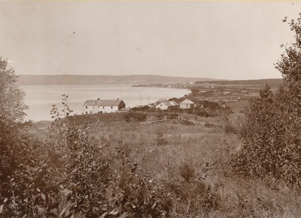
La Pointe, Madelaine Island, Chequamegon Bay, circa 1898.
“The large building in the foreground is an old American Fur Company’s warehouse. The mainland town of Bayfield rests in a hollow of the opposite hills, which appears to merge into the island. This La Pointe, early established as a French military and trading post, must not be confounded with the still earlier missions of La Pointe served by Allouez and Marquette, which is on the mainland on the southwest shore of Chequamegon Bay, between Washburn and Ashland.”
~ Wisconsin Historical Collections, Volume XVI, page 80.
La Pointe has lost much of its old-time significance. No longer is it the refuge of starveling tribes, chased thither by Iroquois, harassed by unneighborly Sioux, and consoled in a measure by the ghostly counsel of Jesuit fathers; no longer a centre of the fur-trade, with coureurs de bois gayly dight, self-seeking English and American factors, Creole traders dispensing largesse to the dusky relatives of their forest brides, and rollicking voyageurs taking no heed of the morrow. Its forest commerce has departed, with the extinction of game and the opening of the Lake Superior country to industrial and agricultural occupation; the Protestant mission has followed the majority of the Indian islanders to mainland reservations; the revived mission of Mother Church has also been quartered upon the bay shore. But the natural charms of Madelaine island, in rocky dell, and matted forest, and sombre, pine-clad shore, are with us still, and over all there floats an aroma of two and a half centuries of historic association, the appreciation of which we need to foster in our materialistic West, for we have none too much of it.
1 The chief authority on Nicolet is Butterfield’s Discovery of the Northwest (Cincinnati, 1881). See also Wis. Hist. Colls., xi, pp. 1-25.
2 In his authoritative “History of the Ojibway Nation,“ in Minn. Hist. Colls., v., Warren prefers the spelling “Chagoumigon,” although recognizing “Shagawaumikong” and “Shaugahwaumikong.” “Chequamegon” is the current modern form. Rev. Edward P. Wheeler, of Ashland, an authority on the Chippewa tongue and traditions, says the pronunciation should be “Sheh-gu-wah-mi-kung,” with the accent on the last syllable.
3 See Nevill and Martin’s Historic Green Bay (Milwaukee,1894); and various articles in the Wisconsin Historical Collections.
4 See Minn. Hist. Colls., v., pp.98, 99, note, for account of early copper mining on Lake Superior by Indians. In the summer of 1892, W. H. Holmes, of the Smithsonian Institution, found on Isle Royale no less than a thousand abandoned shafts which had been worked by them; and “enough stone implements lay around, to stock every museum in the country.”
5 Radisson’s Voyages was published by the Prince Society (Boston, 1895); that portion relation to Wisconsin is reproduced, with notes, in Wis. Hist. Colls., xi. See also Jesuit Relations, 1660, for Father Lallemant’s report of the discoveries of the “two Frenchmen,” who had found “a fine river, great, broad, deep, and comparable, they say, to our great St. Lawrence.”
In Franquelin’s map of 1688, what is now Pigeon River, a part of the international boundary between Minnesota and Canda, is called Groseilliers. An attempt was made by members of the Wisconsin State Historical Society, in the Wisconsin Legislature,during the session of 1895, to have a proposed new county called Radisson; the name was adopted by the friends of the bill, but the measure itself failed to pass.
6 Now called Crees.
7 Radisson’s Voyages plainly indicates that the travelers portaged across the long, narrow sand-spit formerly styled Shagawaumikong, in their day united with the mainland, but now insular, and bearing the name Chequamegon Island; this Radisson describes as “a point of 2 leagues long and some 60 paces broad,”and later he refers to it as “the point that forms that Bay, wch resembles a small lake.” After making this portage of Shagawaumikong, they proceeded in their boats, and “att the end of this bay we landed.” The Ottawas of the party desired to cross over to their villages on the head-waters of the Black and Chippewa, and no landing-place was so advantageous for this purpose as the southwest corner of the bay. It is plain from the narrative that the Frenchmen, now left to themselves, built their fortified hut at or near the place of landing, on the mainland. The Chippewa tradition of the coming of Radisson and Groseilliers, as given by Warren in Minn. Hist. Colls., v., pp. 121, 122, places the camp of the first white men on the eastern extremity of Madeline (or La Pointe) Island. The tradition runs close to the fact in most other particulars; but in the matter of location, Radisson’s journal leaves no room to doubt that the tradition errs.
See post, Father Verwyst’s article, “Historic Sites on Chequamegon Bay,”with notes on the site of Radisson’s fort, by Sam. S. Fifield and Edward P. Wheeler. Verwyst thinks the location to have been “somewhere between Whittlesey’s Creek and Shore’s Landing;” Fifield and Wheeler are confident that it was at Boyd’s Creek.
8 Apparently by Johnathan Carver, in the map accompanying his volume of Travels.
9 Says Warren (Minn. Hist. Colls., v., p. 102): “Shag-a-waum-ik-ong is a narrow neck or point of land about our miles long, and lying nearly parallel to the island of La Pointe, toward the western end of which it converges, till the distance from point to point is not more than two miles.” In first entering the bay, the previous autumn, Radisson describes the point of Shagawaumikong, and says: “That point should be very fitt to build & advantageous for the building of a fort, as we did the spring following.” But later on in his journal, in describing the return to the bay from their winter with the Indians in the Mille Lacs region, he does not mention the exact location of the new “fort.” While in this fort, they “received [news] that the Octanaks [Ottawas] [had] built a fort on the ponit that forms that Bay, wch resembles a small lake. We went towards it with all speede,” – and had a perilous trip thither, across thin ice. This would indicate that the French camp was not on the point. As with many other passages in the journal, it is impossible to reconcile these two statements. Verwyst thinks that the traders were stationed on Houghton Point.
Warren, who had an intimate acquaintance with Chippewa traditions’ believed that that tribe, driven westward by degrees from the shores of the Gulf of St. Lawrence, reached Lake Superior about the time of the Columbian discovery, and came to a stand on Shagaqaumikong Point. “On this spot they remained not long, for they were harassed daily by their warlike foes, and for greater security they were obliged to move their camp to the adjacent island of Mon-in-wun-a-kauning (place of the golden-breasted woodpecker, but known as La Pointe). Here, they chose the site of their ancient town, and it covered a space about three miles long and two broad, comprising the western end of the island.” – (Minn. Hist. Colls., v., p. 96). They remained in this large town “for the space of three generations, or one hundred and twenty years,” but for various reasons (see Ibid, p. 108 et seq., for the details) evacuated the place, and settling on the adjacent mainland came to regard La Pointe Island (now Madeline) as an abode of evil spirits, upon which, it is said, until the days of Cadotte, no Indian dare stay over night alone. Gradually, as the beaver grew more scarce, the Chippewas radiated inland, so that at the time of Radisson’s visit the shores of the bay were almost unoccupied, save during the best fishing season, when Chippewas, Ottawas, Hurons, and others congregated there in considerable numbers.
10 The route which Ménard took, is involved in doubt. Verwyst, following the Jesuit Relations, thinks he ascended some stream flowing into Lake Superior, and portaged over to the head-waters of Black river. Others, following Tailhan’s Perrot, believe that he crossed over to Green Bay, then ascended the Fox, descended the Wisconsin, and ascended the Mississippi to the mouth of the black. If the latter was his route, his visit to the Mississippi preceded Joliet’s by eleven years.
11 Neill (in Minn. Hist. Colls., v., p. 116) is of the opinion that Allouez “built a bark chapel on the shores of the bay, between a village of Petun Hurons and a village composed of three bands of Ottawas.” That Allouez was stationed upon the mainland, where the Indians now were, is evident from his description of the bay (Jesuit Relations for 1666-67): “A beautiful bay, at the bottom of which is situated the great village of the savages, who there plant their fields of Indian corn, and lead a stationary life. There are there, to the number of eight hundred men bearing arms, but collected from seven different nations, who dwell in peace with each other.” Verwyst, whose local knowledge is thorough, thinks that Allouez’s mission was at the mouth of Vanderventer’s Creek, and I have followed him in this regard.
There has always been some confusion among antiquarians as to what particular topographical feature gave name to the region. In christening his mission “La Pointe,” he had reference, I think, not to the particular plot of ground on which his chapel lay, but to the neighboring sandy point of Shagawaumikong, hemming in the bay on the east, in which he must have had a poetic interest, for tradition told him that it was the landfall of the Chippewas, and the place where, perhaps a century before, had been fought a great battle between them and the Dakotah’s (or Sioux), relics of which were to be found in our own day, in the human bones scattered freely through the shifting soil; doubtless in his time, these were much in evidence.
The map of in the Jesuit Relations for 1670-71 styles the entire Bayfield peninsula, forming the west shore of the bay, “La Pointe du St. Esprit,” of 1688, more exact in every particular, places a small settlement near the southwestern extremity of the bay. See also Verwyst’s Missionary Labors of Fathers Marquette, Ménard, and Allouez (Milwaukee, 1886), p. 183.
In 1820, Cass and Schoolcraft visited Chequamegon Bay, and the latter, in his Narrative, says: “Passing this [Bad] River, we continued along the sandy formation to its extreme termination, which separates the Bay of St. Charles [Chequamegon] from that remarkable group of islands called the Twelve Apostles by Carver. It is this sandy point which is called La Pointe Chagoimegon by the old French authors, a term no shortened to La Pointe.”
12 By this time, fear of the Iroquois had subsided, and many Hurons had lately returned with the Pottawattomies, Sauks, and Foxes, to the oldhaunts of the latter, on Fox River. Cadillac, writing in 1703 from Detroit, says (Margry, v., p. 317): “It is proper that you should be informed that more than fifty years since [about 1645] the Iroquois by force of arms drove nearly all of the other Indian nations from this region [Lake Huron] to the extremity of Lake Superior, a country north of this post, and frightfully baren and inhispitable. About thirty-two years ago [1671] these exiled tribes collected themselves together at Michillimakinak.”
13 “The cause of the perpetual war, carried on between these two nations, is this, that both claim, as their exclusive hunting ground, the tract of country which lies between them, and uniformly attack each other when they meet upon it.” – Henry’s Travels and Adventures (N. Y., 1809), pp. 197, 198.
14 From whom the city of Duluth, Minn. was named.
15 For an account of Grand Portage see Wis. Hist. Colls., xi., pp. 123-125.
16 See ante, p. 203, note, for description of the Bois Brulé-St. Croix route.
17 See Parkman’s Half Century of Conflict, and Hebberd’s Wisconsin under French Domination (Madison, 1890).
18 Neill, in Minn. Hist. Colls., v. p 140, says that soon after St. Lusson’s taking possession of the Northwest for France, at Sault. Ste. Marie (1671), French traders built a small fort set about with cedar palisades, on which a cannon was mounted, “at the mouth of a small creek or pond midway between the present location of the American Fur Company’s establishment and the mission-house of the American Board of Foreign Missions.”
19 Minn. Hist. Colls., v., p. 125. Originally, the Indians of Lake Superior went to Quebec to trade; but, as the whites penetrated westward by degrees, these commercial visits were restricted to Montreal, Niagara, Detroit, Mackinaw, Sault Ste. Marie, as each in turn became the outpost of French influence; finally trading-posts were opeend at La Pointe, St. Louis River, and Pigeon River, and in time traders even followed the savages on their long hunts after the ever-decreasing game.
20 In July, 1695, Chingouabé, Chief of the Chippewas, voyaged with Le Sueur to Montreal, to “pay his respects to Onontio, in the name of the young warriors of Point Chagouamigon, and to thank him for having given them some Frenchmen to dwell with them; and to testify their sorrow for one Jobin, a Frenchmen killed at a feast. It occurred accidentally, not maliciously.” In his reply (July 29), Governor Frontenac gave the Chippewas some good advice, and said that he would again send Le Sueur “to command at Chagouamigon.” – Minn. Hist. Colls., v., p. 421.
21 It is evident that hereafter Madelaine Island was the chief seat of French power in Chequamegon Bay, but it was not until the present century that either the name La Pointe or Madelaine was applied to the island. Franquelin’s map (1688) calls it “Isle Detour ou St Michel.” Bellin’s French map of Lake Superior (in Charlevoix’s Histoire et Description Générale de Nouvelle France, Paris, 1744) calls the long sand-point of Shagawaumikong (now Chequamegon Island), “Pointe de Chagauamigon,” and styles the present Madelain Island “Isle La Ronde” after the trader La Ronde; what is now Basswood Island, he calls “Isle Michel,” and at the southern extremity of the bay indicates that at that place was once an important Indian village. In De l’ Isle’s map, of 1745, a French trading house (Maison Francoise) is shown on Shagawaumikong Point itself. Madelaine Island has at various times been known as Monegoinaiccauning (or Moningwnakauning, Chippewa for “golden-breasted woodpecker”), St. Michel, La Ronde, Woodpecker, Montreal, Virginia (Schoolcraft, 1820), Michael’s (McKenney, 1826), Middle (because midway between the stations of Saulte Ste. Marie and Fort William, at Pigeon River), Cadotte’s, and La Pointe (the latter because La pointe village was situated thereon).
22 Minn. Hist. Colls., v., pp. 423-425.
23 It was during this period the only fur-trading station on the south shore of Lake Superior, and was admirably situated for protecting not only the west end of the lake, but the popular portage route between Lake Superior and the Mississippi River, – the Bois Brulé and the St. Croix Rivers.
24 J. D. Butler’s “Early Shipping on Lake Superior,” in Wis. Hist. Soc. Proc., 1894, p. 87. The rigging and material were taken in canoes from the lower country to Sault Ste. Marie, the vessel being built at Point aux Pins, on the north shore, seven miles above the Sault. Butler shows that Alexander Henry was interested with a mining company in launching upon the lake in May, 1771, a sloop of 70 tons. After this, sailing vessels were regularly employed upon Superior, in the prosecution of the fur trade and copper mining. The Hudson’s Bay Company’s “Speedwell” was upon the lake as early as 1789; the Northwest Company’s principal vessel was the “Beaver.”
25 In this year there were reported to be 150 Chippewa braves living on Point Chagouamigon. — N. Y. Colon. Docs., ix.
26 Martin MSS., Dominion Archives, Ottawa, – letter of Beauharnois. For much of the foregoing data, see Neill’s “History of the Ojibways,” Minn. Hist. Colls., v.
27 N. Y. Colon. Docs., x., p. 424
28 Says Governor Galissoniére, in writing to the colonial office at Paris, under date of October, 1748: “Voyageurs robbed and maltreated at Sault Ste. Marie, and elsewhere on Lake Superior; in fine there appears to be no security anywhere.” – N. Y. Colon. Docs., x. p. 182.
29 See the several versions of this tale, Wis. Hist. Colls., viii., pp. 224 et seq.; and Minn. Hist. Colls., v., pp. 141-145, 431-432. Warren says that some Chippewa traditions ascribe this tragedy to the year 1722, but the weight of evidence is as in the text above.
30 “My house, which stood in the bay, was sheltered by an island of fifteen miles in length, and betwen which and the main the channel is four miles broad. On the island there was formerly a French trading post, much frequented; and in its neighborhood a large Indian village.” – Henry’s Travels, p. 199. Henry doubtless means that formerly there was an Indian village on the island; until after the coming of Cadotte, Warren says, the island was thought by the natives to be bewitched.
31 Jean Baptiste Cadotte (formerly spelled Cadot) was the son of one Cadeau, who is said to have come to the Northwest in the train of Sieur de St. Lusson, who took possession of the region centring at Sault Ste. Marie, in 1671. See St. Lusson’s procés verbal in Wis. Hist. Colls., xi., p. 26. Jean Baptiste, who was legally married to a Chippewa woman, had two sons, Jean Paptiste and Michel, both of whom were extensive traders and in their turn married Chippewas. See Minn. Hist. Colls., v., index.
32 “On my arrival at Chagouenig, I found fifty lodges of Indians there. These people were almost naked, their trade having been interrupted first by the English invasion of Canada, and next by Pontiac’s war.” – Travels, p. 193.
33 McKenny, in History of the Indian Tribes (Phila., 1854), i., pp. 154, 155, tells the story. He speaks of Johnston as “the accomplished Irish gentleman who resided so many years at the Sault de Ste. Marie, and who was not better known for his intelligence and polished manners than for his hospitality.” See also, ante, pp. 180, 181, for Schoolcraft and Doty’s notices of Johnston, who died ([ae]t. 66) at Sault Ste. Marie, Sept. 22, 1828. His widow became a Presbyterian, and built a church of that denomination at the Sault. Her daughter married Henry B. Schoolcraft, the historian of the Indian tribes. Waubojeeg died at an advanced age, in 1793.
34 Warren thinks he settled there about 1792 (Minn. Hist. Colls., v., p.111), but there is good evidence that it was at a later date.
35 “The Cranes claim the honor of first having pitched their wigwam and lighted the fire of the Ojibways, at Shaug-ah-waum-ik-ong, a sand point or peninsula lying two miles immediately opposite the Island of La Pointe.” – Warren in Minn. Hist. Colls., v., p. 86.
36 “Kind-hearted Michel Cadotte,” as Warren calls him, also had a trading-post at Lac Courte Oreille. He was, like the other Wisconsin Creole traders, in English employ during the War of 1812-15, and was at the capture of Mackinaw in 1812. He died on the island, July 8, 1837, aged 72 years, and was buried there. As with most of his kind, he made money freely and spent it with prodigality, partly in high living, but mainly in supporting his many Indian relatives; as a consequence, he died poor, the usual fate of men of his type. – (Minn. Hist. Colls., v., p. 449.) Warren says (Ibid., p. 11), the death occurred “in 1836,” but the tombstone gives the above date.
Cass, Schoolcraft, and Doty visited Chequamegon Bay in 1820. Schoolcraft says, in his Narrative, pp. 192, 193: “Six mile beyond the Mauvaise is Pointe Che-goi-me-gon, once the grand rendezvous of the Chippeway tribe, but now reduced to a few lodges. Three miles further west is the island of St. Michel (Madelaine), which lies in the traverse across Chegoimegon Bay, where M. Cadotte has an establishment. This was formerly an important trading post, but is now dwindled to nothing. There is a dwelling of logs, stockaded in the usual manner of trading-housess, besides several out-buildings, and some land in cultivation. We here also found several cows and horses, which have been transported with great labor.” See ante, pp. 200, 201, for Doty’s account of this visit.
37 Alfred Brunson, who visited Lyman Warren at La Pointe, in 1843, wrote: “Mr. Warren had a large and select library, an unexpected sight in an Indian country, containing some books that I had never before seen.” – Brunson, Western Pioneer (Cincinnati, 1879), ii., p. 163.
38 Minn. Hist. Colls., v., pp. 326, 383, 384, 450. Contemporaneously with the settlement of the Warrens at La Pointe, Lieutenant Bayfield of the British navy made (1822-23) surveys from which he prepared the first accurate chart of Lake Superior; his name is preserved in Bayfield peninsula, county, and town.
39 Borup had a trading-post on the island in 1846; but the forest commence had by this time sadly dwindled.
40 He left six children, the oldest son being William Whipple Warren, historian of the Chippewa tribe. See William’s “Memoir of William W. Warren,” in Minn. Hist. Colls., v.
41 See Davidson’s excellent “Missions on Chequamegon Bay,” in Wis. Hist. Colls., xii., to which I am chiefly indebted for information concerning the modern La Pointe missions. Mr. Davidson has since given us, in his Unnamed Wisconsin (Milw., 1895), fuller details of this mission work.
42 Wis. Hist. Colls., xii., p. 445. Mr. Davidson writes to me that in his opinion Ayer leaned to independency, and was really a Congregationalist; Hall is registered as such in the Congregational Year Book for 1859. “As to the La Pointe-Odanah church,” continues Mr. Davidson, in his personal letter, “its early records make no mention of lay elders, – of organization it was independent, rather than strictly Congregational. This could not be otherwise, with no church nearer than the one at Mackinaw. That was Presbyterian, as was its pastor, Rev. William M. Ferry. The La Pointe church adopted articles of faith of its own choosing, instead of holding itself bound by the Westminster confession. Moreover, the church was reorganized after the mission was transferred to the Presbyterian board. For this action there may have been some special reason that I know nothing about. But it seems to me a needless procedure if the church were Presbyterian before.”
43 See Verwyst’s Missionary Labors, pp. 146-149. This chapel was built partly of new logs, and partly of material from an old building given to Father Baraga by the American Fur Company
44 See Wis. Hist. Colls., xii., pp. 445, 446, note, also, Verwyst’s Missionary Labors, pp. 183, 184. Father Verwyst also calls attention to certain vestments at La Pointe, said to be those of Marquette: “That is another fable which we feel it our duty to explode. The vestments there were procured by Bishop Baraga and his successors; not one of them dates from the seventeenth century.”
By Amorin Mello
In our Penoka Survey Incidents series earlier this year, we followed some of the adventures and schemes of Albert Conrad Stuntz circa 1857. The legacy of Albert’s influential survey still defines the geopolitical landscape of the Penokee Mountains to this day. However, Albert’s work during the late 1850s was relatively minor in comparison to that of his brother, George Riley Stuntz, during the early 1850s. The surveying work of George and his employees started in 1852 and enabled the infamous land speculators and townsite promotors of Superior City to manifest their schemes by early 1854 (months before the Treaty of La Point occurred later that year).
Among the men that worked with George was Augustus Hamilton Barber. Sometime around 1850, Augustus had followed his Grandparents, Aunts, Uncles, and Cousins from the Barber family of Lamoille County, Vermont, to Lancaster in Grant County, Wisconsin. After a short career as a school teacher in Grant County, Augustus came to Lake Superior in 1852 employed by George as a Chainman under his contract with the United States General Land Office to survey lands at the Head of Lake Superior.
Before taking a closer look at the Barber Papers, let’s examine the lives and affairs of other surveyors and speculators along the southwest shore of Lake Superior, starting with George Riley Stuntz and his production of these Exterior Field Notes (June of 1852):


Duluth and St. Louis County, Minnesota;
Their Story and People
By Walter Van Brunt, 1921, pages 64-65.

Portrait of George Nettleton’s cabin on Minnesota Point in 1852 on page 75.
First Settler.– The honor, for both Superior and Duluth, must presumably go to George R. Stuntz. He came in 1852, and settled in 1853. Several were earlier of course, but can hardly be considered to have been legitimate independent settlers. Carlton had been on the ground, at Fond du Lac, for some years, but he was Indian agent; Borup and Oaks had spent their time between La Pointe and Fond du Lac, but were then at St. Paul, and mainly interested in the development of that city, and in fur trading. Wm. R. Marshall stated that he “was on the lake as early as 1848,” but not to settle and he did not come again until 1857. Wm. R. Marshall and George R. Stuntz were fellow-surveyors, in federal pay, “back in the ’40s,” but Marshall did not seek to take the place of Stuntz as premier pioneer at the head of Lake Superior. As a matter of fact, although “on the lake as early as “1848,” Marshall did not then get nearer to Duluth than La Pointe, where he met “Borup and Oaks, the principal traders, Truman Warren, George Nettleton, Cruttenden, Wattrous, Rev. Sherman Hall, E. F. Ely and others.” It is quite possible that Stuntz was with Marshall in 1848, for that was the year in which Stuntz first entered Minnesota territory “having charge of a surveying party that was working near Lake Pepin and in what is now Washington County.”
The “Heart of the Continent.”– George R. Stuntz prepared the way for the first attempt at white settlement at the head of Lake Superior. He surveyed the land on the Wisconsin side, within a year of beginning which survey, in 1852, the first settlers began to appear. George R. Stuntz came by direction of George B. Sargent, who at the time was surveyor-general of the Iowa, Wisconsin and Minnesota district for the federal government, his headquarters being at Davenport, Iowa. In that year, states Carey, “he surveyed and definitely located a portion of the northeastern boundary line between Minnesota and Wisconsin, starting from the head of navigation on the St. Louis River, at Fond du Lac, and running south to the St. Croix River.” Stuntz himself stated: “I came in 1852. I saw the advantages of this point (Minnesota Point) as clearly then as I do now (1892). On finishing the survey for the government, I went away to make a report, and returned the next spring and came for good. I saw as surely then as I do now that this was the heart of the continent commercially, and so I drove my stakes.”
![Group of people, including a number of Ojibwe at Minnesota Point, Duluth, Minnesota [featuring William Howenstein] ~ University of Minnesota Duluth, Kathryn A. Martin Library](https://chequamegonhistory.com/wp-content/uploads/2015/06/howenstein-minnesota-point.jpg)
Group of people, including a number of Ojibwe at Minnesota Point, Duluth, Minnesota [featuring William Howenstein in 1872?] ~ University of Minnesota Duluth
The Vanguard.– He did not come alone, needing of course assistants in the work of surveying, but he was in charge of the work, Gand necessarily takes first place in the accounting. William C. Sargent, son of George B. Sargent, stated in 1916, that his father “came here (Duluth) first in 1852 with George R. Stuntz and Bill Howenstein,” and goes on to state “a word of those two grand men, George R. Stuntz and Bill Howenstein.” He believed that “to George R. Stuntz, more than to any other man belongs the honor (of) opening up that region,” and of Howenstein, he said: “And old Bill Howenstein, one of the best ever, and always my very good friend, a kindly body, with a quaint dry humor unsurpassed and seldom met with in these later days. I had many an interesting chat with him, in his home on Minnesota Point, that he built in 1852, and lived in until his death, some years ago.” Bill Howenstein, undoubtedly was of Stuntz’ party in 1852, but it is doubtful whether he built a log house on Minnesota Point in that year. As to General Sargent’s visit in 1852. If he did come then, it was probably only a flying visit. His interest in the head of Lake Superior in 1852 reached only to the extent of directing Stuntz to survey it. He, himself, had the surveying business of three states to attend to.
The New York Times
[December 11, 1852]
The Region about the Southwest End of Lake Superior.
Mr. Stuntz, of Grant County, Wis., has been deputed by the general Land Surveyor of this Northwest District to lay off such a tract of land about the southwest point of the lake into townships and sections, as emigrants will earliest require. He returned via La Pointe and Stillwater last week. We have obtained from him some new views of that region. From Fond du Lac, a trading post situated 11 miles inland on the St. Louis River, eastward, for perhaps 50 miles, the margin of the lake is a flat strip of land reaching back to a rocky ridge about 11 miles off. The soil of this flat land is a rich red clay. The wood is white cedar and pine of the most magnificent growth. The American line is beyond the mouth of the St. Louis and Pigeon rivers. It evidently abounds in copper, iron and silver. The terrestrial compass cannot be used there, so strong is the attraction to the earth. The needle rears and plunges “like mad.” Points of survey have to be fixed by the solar compass.
The Indian and half breed packmen have astonishing strength. One Indian, who is described by the others as being as large as two men, carried for a company of 11 men provisions for ten days, viz: one barrel of flour, half barrel of pork and something else, beside the utensils. Mirage is a common phenomenon is Spring and Summer. For the bays not opening as soon as the main lake, or not cooling so early, an object out on the lake, is viewed from the shore, through a dense medium of air and a thin medium. Hence is a refraction of rays which gives so many wonderful sights that the Chippewas call that the spirit or enchanted land. Sail vessels which are really 40 miles off, are seen flapping and bellying about almost within touch. Turreted Islands, look heavy and toppling towards the zenith. Forests seem to leap from their stems and go a soaring like thistles for the very sport of it.
The ice did not leave some of the bays till the 10th of June. The fish are delicious, especially the salmon trout. But little land game. Mr. Stunts calculates on wonderful enterprises in that country after the opening of the Saut Canal.
Mr. S. describes La Pointe a town of the Lake, as being situated at the head of a bay some 25 miles from the high lake, and secluded from the lake by several islands. He saw there a warehouse 300 feet long, built of tamarac poles, and roofed with bark. This building is very much warped by the pressure of age ; it is entered by a wooden railway. The town is dingy and dreary. He saw a most luxurious garden by the former residence of Dr. Borup. It contained a variety of fruit trees and shrubs, such as plums, cherries, apples, pears, currants, &c.

Cover of Stuntz’s Exterior Field Notes (August-October 1852) ~ Wisconsin Public Land Survey Records: Original Field Notes and Plat Maps

George Riley Stuntz was also assisted by his brother Albert Conrad Stuntz as well as the African-Chippewa mixed-blood Stephen Bonga employed as an Axeman. To learn more about the interesting Bonga (Bonza) family and Stephen as “the first white child born at the head of Lake Superior,” read pages 39-41 of The Black West by William Loren Katz (1971), and pages 131-34 of Black Indians also by Katz (2012).
The Eye of the North-west: First Annual Report of the Statistician of Superior, Wisconsin
By Frank Abial Flower, 1890

Portrait of Stephen Bonga, page 7.
GEORGE R. STUNTZ, DEPUTY U. S. SURVEYOR [pages 50-52]

Portrait of George Riley Stuntz, page 26.
In 1852 George R. Stuntz took a contract to run the township lines in this part of the country, including the state boundary, and filed with the land-office at Dubuque a rude map of the head of the lake, on the Wisconsin side, in December of that year. He took a new contract and returned in the spring of 1853 to survey the copper range around Black River, a few miles south of Superior. He brought seeds with him and planting them on the Namdji, raised a quantity of vegetables; they grew to great size. he also built a trading-post on Minnesota point near the present light-house, and a mill on Iron River in Bayfield county. In respect of these operations W. W. Ward writes from Morley, Mo.:
The first lumber of any description produced locally, other than by “Whip sawing”, was at Iron River, Wisconsin about forty miles from Superior on the South Shore of Lake Superior.
George R. Stuntz with William C. Howenstein, Andrew Reefer and George Falkner built and operated a water power “up and down” sawmill at the falls on Iron River about a half a mile from the Lake, capable of cutting three thousand feet of lumber a day. The writer has several 1 1/4 inch absolutely “clear” White Pine boards 24 and 26 inches wide and 18 feet long that were originally stored in a loft to be used in building a skiff. This mill was built in 1854 and the lumber was floated up the Lake to Superior, Oneota and Fond du Lac…
~ Superior, Wisconsin, papers, 1831-1942 ([unpublished])
From “A Pioneer of Old Superior” by Lillian Kimball Stewart
“In the summer of ’54 the Sam Ward plying between the Sault and any port on Lake Superior, brought on every trip a goodly number of emigrants, speculators, and tourists, bent on seeing the new “city” of Superior. Stuntz’s dock was located near an Indian village, so that every traveler as well as every piece of freight or baggage was subject to inspection by braves, squaws, and papooses before receiving a passport to the shore across the bay…”
~ Superior, Wisconsin, papers, 1831-1942 ([unpublished])
“It was in the spring of 1853 that Mr. Stuntz, Deputy U. S. Surveyor, received his second contract to survey and run the township lines taking in the range around Black River Falls, a portion of Left-hand River country and that part where Superior now is. In the latter part of April that year he organized a party – viz., Nat. W. Kendall, James McKinzie, Pain Bradt, James McBride, Harvey Fargo, Wm. H. Reed, John Chisholm, Joseph Latham, Augustus Barber, and your humble servant. Procured three birch-bark canoes and supplies at Stillwater, Minn.: left there the first day of May, passed up the St. Croix River to its head, made a portage of about two and a half miles into the headwaters of the Brule River, down said river into Lake Superior, thence up the lake to what was called the entry of St. Louis Bay [now Superior Bay], and landed on Minnesota Point in the early part of June. At that time there were no white settlers in this end of the lake – all Chippewa Indians and ‘breeds’ – scarcely a stick missing on that side of the bay where Superior City now stands. We finished the surveying contract and went in early fall down to Iron River, built a double log-shanty, and made other preparations for the construction of a saw mill. Here the first lumber was made at the head of the lake and the first road opened through to the settlement on the St. Croix. The following February, Mr. Stuntz having a trading-post on Minnesota Point [then Stuntz’s Point], I went there and assisted in building a block-house and steamboat pier, and found improvements and a few log-shanties built where old Superior now is located.”
[…]
HUSTLING FOR TOWNSITES [pages 58-60]
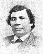
Vincent Roy Jr. ~ Life and Labors of Rt. Rev. Frederic Baraga by Chrysostom Verwyst,
VI. – Superior.
Vincent [Roy Jr.] had barely emerged from the trouble just described when it was necessary for him to exert himself in another direction. A year or so previously he had taken up a claim of land at the headwaters of Lake Superior and there was improvement now on foot for that part of the country, and danger for his interests.
The ship canal at Sault St Marie was in course of construction and it was evidently but a question of days that boats afloat on Lakes Huron and Michigan would be able to run up and unload their cargo for regions further inland somewhere on the shore at the further end of Lake Superior, at which a place, no doubt, a city would be built. The place now occupied by the city of Superior was suitable for the purposes in view but to set it in order and to own the greatest possible part of it, had become all at the same time the cherished idea of too many different elements as that developments could go on smoothly. Three independent crews were struggling to establish themselves at the lower or east end of the bay when a fourth crew approached at the upper or west end, with which Vincent, his brother Frank, and others of LaPointe had joined in. As this crew went directly to and began operations at the place where Vincent had his property it seems to have been guided by him, though it was in reality under the leadership of Wm. Nettleton who was backed by Hon. Henry M. Rice of St. Paul. Without delay the party set to work surveying the land and “improving” each claim, as soon as it was marked off, by building some kind of a log-house upon it. The hewing of timber may have attracted the attention of the other crews at the lower end about two or three miles off, as they came up about noon to see what was going on. The parties met about halfway down the bay at a place where a small creek winds its way through a rugged ravine and falls into the bay. Prospects were anything but pleasant at first at the meeting; for a time it seemed that a battle was to be fought, which however did not take place but the parceling out of ‘claims’ was for the time being suspended. This was in March or April 1854. Hereafter some transacting went on back the curtain, and before long it came out that the interests of the town-site of Superior, as far as necessary for efficient action, were united into a land company of which public and prominent view of New York, Washington, D.C. and other places east of the Mississippi river were the stockholders. Such interests as were not represented in the company were satisfied which meant for some of them that they were set aside for deficiency of right or title to a consideration. The townsite of the Superior of those days was laid out on both sides of the Nemadji river about two or three miles into the country with a base along the water edge about half way up Superior bay, so that Vincent with his property at the upper end of the bay, was pretty well out of the way of the land company, but there were an way such as thought his land a desirable thing and they contested his title in spite of his holding it already for a considerable time. An argument on hand in those days was, that persons of mixed blood were incapable of making a legal claim of land. The assertion looks more like a bugaboo invented for the purpose to get rid of persons in the way than something founded upon law and reason, yet at that time some effect was obtained with it. Vincent managed, however, to ward off all intrusion upon his property, holding it under every possible title, ‘preemption’ etc., until the treaty of LaPointe in the following September, when it was settled upon his name by title of United States scrip so called, that is by reason of the clause, as said above, entered into the second article of that treaty.
The subsequent fate of the piece of land here in question was that Vincent held it through the varying fortune of the ‘head of the lake’ for a period of about thirty six years until it had greatly risen in value, and when the west end was getting pretty much the more important complex of Superior, an English syndicate paid the sum of twenty five thousand dollars, of which was then embodied in a tract afterwards known as “Roy’s Addition”.
~ Biographical Sketch – Vincent Roy Jr; Vincent Roy Jr. Papers.
Up to the time of the survey in the spring of 1854 all was chaos as to lands west of the claims of Robertson, Nelson, Baker and their party. There could be no titles or bona fide purchases, as only the mouth of the Nemadji had been surveyed. There were really three “townsite” companies— Robertson, Nelson and Baker, with their associates J. A. Bullen, J. T. Morgan, E. Y. Shelly, August Zachau, C. G. Pettys, Abraham Emmett, and perhaps others, forming one which had the surveyed lands next to the Nemadji. West of them were Francis Roy, Benjamin Cadotte, Robert Bothwick, Basil Dennis, Charles Knowlton and nearly a dozen half-breeds, mostly brought from Crow Wing by Nettleton in the interest of what was known as the “Hollinshead crowd”—Edmund and Henry M. Rice, George L. Becker, Wm. and George W. Nettleton, Benjamin Thompson, James Stinson and W. H. Newton. Still farther west were Benjamin W. Brunson, A. A. Parker, R. F. Slaughter, C. D. Kimball, Rev. E. F. Ely, George R. Stuntz, Bradley Salter, Joseph Kimball, Calvin Hood, and others who proposed to call their town Endion—”Ahn-dy-yon,” the Chippewa for “home.”
B. W. Brunson, still a resident of St. Paul, has described the contest in writing. He says:
“Believing Superior would become of importance I went there in February, 1854, with R. F. Slaughter. We found some Ontonagon parties had claimed on the bay and we bought an interest in their claims and began to lay out a city and make improvements. While surveying the town, and when we had the same so far completed as to make a plat of it, the township having been subdivided by a good surveyor, then it was that Vincent Roy, Basil Dennis, Charles Brissette and Antoine Warren, accompanied by twenty-one other half-breeds and some four or five white men, headed, led and directed by one Stinson and one Thompson, who were acting for themselves and as agents of the company, came upon the lands to make their claims and avail themselves of pre-emption rights as citizens of the United States. These men were in the employ of the company for the purpose of making claims, and there was a claimant for each and every quarter-section as fast as the surveyor set the quarter-post. They had commenced the day before, with or at the same time the surveyor commenced his work. The timber being dense and there being a strong force, they were able to build an 8×10 cabin and cover it with boughs, upon each quarter, and then overtake the surveyor before he could establish the next quarter, thus taking the land as they went, and in that manner were progressing when they came upon the land marked out and occupied by us.“
The meeting of the two hostile parties occurred on the banks of the deep slough in what is now called Central Park. Nothing but the timidity of the half-breeds prevented bloodshed. Brunson was armed and intended to, and did stand his ground. Thompson, one of the pluckiest of men, was also armed, having two revolvers, and was prepared and intended to proceed. The Indians, not being armed, did not wish to engage in a battle where the leaders only were prepared to fight; and so there was no physical conflict, though a state of chaos and bad feeling continued for some time. Several cabins were demolished, Brunson’s party entirely cutting in pieces a house built by Basil Dennis on the ground now occupied by Dr. Conan’s fine residence.
A long legal contest followed. Finally in 1862-63 patents issued from the government to three men—S. W. Smith, Lars Lenroot and Oliver Lemerise—chosen as trustees of the townsite for the benefit of actual occupants. Thus those who claimed to be proprietors of, but not settlers on the townsite, lost their lands as well as their labor. In the winter of 1853-54 Henry M. Rice asked the Commissioner of the General Land Office whether, when lands which had not been surveyed were claimed for a townsite they would be liable to pre-emption as soon as the survey should be made. The answer was in favor of pre-emption; and that is how those who with Brunson put money into Superior City townsite lost it. The actual settlers got the townsite, the patent being made to the three trustees named who divided the plat, containing 240 acres with riparian rights in Superior Bay, and deeded lots to occupants and purchasers. It may be proper to mention here that a little plat of thirty-four acres, with riparian rights in the bay, and known as Middletown, went through a similar siege of litigation and was finally patented to three trustees —Urguelle Gouge, Louis Morrisette and Nicholas Poulliott—for the benefit of actual occupants. These decisions did not come until the “city” had collapsed and the land become nearly worthless.
The New York Times
[June 19th, 1858]
WESTERN LAND FRAUDS.
More Blood in the Body than Shows in the Face – Land Frauds in the Northwest – The Superior City Controversy – Pre-emptions by Swedes and Indians
Washington, Thursday, June 17, 1858.
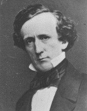
Senator Henry Mower Rice
~ United States Senate Historical Office
There are some interesting matters here besides what takes place in Congress, and I propose from time to time to touch upon them. An expenditure of $60,000,000 per annum does not cover all the pickings and stealings that “prevail” in our hereabouts. Senator RICE did not tell all he knew about land-office operations, when he testified to the value of the Fort Snelling property. Nobody is better aware than he that the tract would be much better to cut up into town lots than Bayfield was when he bought it for a few cents an acre, and sold it for hundreds of dollars. If we could find out all that Senator BRIGHT knows of these matters, one could learn how to become a millionaire at very small expense of brains or labor. Indian treaties and land-office jobbing have made more men rich than care to tell of it – ask General CASS if this is not so.
Seeing a bushel-basket of papers in the Interior Department the other day, I was curious to know what the kernel might be to all that rind, and made inquiry in the premises. I was told that they enveloped the case of Superior City. I cast my eye over some of them, and noticed that an argument was filed on behalf of one of the parties by Mr. Senator BRIGHT – or rather with Senator BRIGHT’S indorsement. This whetted my desire of knowledge, and I ran my eye over the paper in question, which was from the pen of a Minnesota Judge and was without exception the richest document I ever saw intended for a judicial or administrative tribunal. The substance of it was that the opinion of the Attorney-General CUSHING in the case was absurd, the adoption of his views by the Interior Department preposterous, and the action of the local Land office at Superior, in defining the status of certain half-breed Indians on the most abundant testimony, corrupt. It was clear enough that such a document required at least a senatorial indorsement to justify its reception. Nobody can suppose for a moment that Senator BRIGHT has any interest in the result of the case, or that he expected to influence the judgement of his friend, HENDRICKS, (Commissioner of the General Land Office,) by appearing in it. That would be too strong an inference to draw from so meek a fact ; and yet the malicious might suggest it as an apprehension.

Original Proprietors of Superior featuring James Stinson, Benjamin Thomson, Dr. W.W. Coran, U.S. Senator Robert J Walker, George W. Cass, and Horace Bridge. Featured in The Eye of the North-west, pg. 8.
From the printed argument of Senator BRIGHT’S friend, and from a private abstract of the testimony in the case, and a few items I have picked up in the Land Office, I think it will be in my power to indite an epistle that may excite some attention. At the Southwestern extremity of Lake Superior, there is a tract of land, which is expected some day to become the cite of a large city. Being aware of its great advantages for this purpose, a St. Paul speculator by the name of THOMPSON, and a Canadian operator by the name of STINSON, undertook to possess themselves of it as long as as in the early part of General PIERCE‘S administration, by vicarious preemptions. In this plan they were assisted by some official gentlement, who shared in the spoils, and patents were ground out in double-quick time, or certificates issued to Swedes and Indians for the benefit of this STINSON and THOMPSON, and their associate speculators.
More Proprietors of Supeior from The Eye of the North-west, pg. 9.
In the Summer of 1854, this Mr. STINSON, headed a gang of Swedes and led them from Swede Lake, in the Territory of Minnesota, to Lake Superior, guiding them in person to the tracts he wished them to preempt. These men were ignorant of our language and of our laws, and were used by STINSON to “settle” their tracts, “prove up” their claims, and “convey” to him, the said STINSON, without knowing either the frauds they were practicing, or the rights which they might have secured to themselves if they had been acting in good faith. In the Land Office at Hudson, where these frauds were perpetrated, there was a notary public, who drew the deeds to STINSON, got the signatures of the Swedes to them and took the acknowledgements, immediately after the preemption oath had been administered – the Swedes thinking the whole operation a part of the preemption process. The terms were said to be $30 a month, and a bonus of $15 on the consummation of the bargain. The names of these Swedes were Aaron Peterson, Martin Larson, Peter Nelson, John Johnson, Sven Magnassan, Lorenz Johnson, Peter Norell, Sven Larson, Andreas Senson, Johannes Helon, Johannes Peterson, and Peter Erickson. These “preemptors,” for their own benefit, all “proved up” at Hudson, and the very same day they made conveyances to STINSON. The same thing is true of another Swedish invasion that was made in the Summer of 1855. In that year three Swedes – Old Westerland, Andrew Walmart, and Israel Janssen – commenced their settlements June 11, proved up June 22, and conveyed to STINSON June 22 – eleven days being sufficient for the whole operation. The records of the Land Office at Superior, and of the Register of Deeds of Douglas County, show these facts. They are well known in the General Land Office.
But Mr. STINSON did not operate through Swedes alone. He and his friend THOMPSON worked with half-breed Indians also. In March, 1854, he and THOMPSON followed up the Government Surveys with a gang of Chippewa half-breed Indians. The whole gang made preemptions in Douglas County, under the guidance of THOMPSON and STINSON, who hired them at La Pointe, and convered a large portion of a township with their fraudulent pre-emptions, which were proved up simultaneously, and simultaneously conveyed to the attorney of THOMPSON and STINSON. The names of all of this gang appear on the tract books in the General Land Office. These were Joseph Lamoureaux, Joseph Defaut, Joseph Dennis, Joseph Gauthier, Francis Decoteau, John B. Goslin, George D. Morrison and Levi B. Coffee, all preemptors for these land-sharks. There were three or four more half-breeds in the gang, who ran foul of some eight or ten American citizens who were seeking to save a slice of this Territory from Swedish and Indian preemption, and lay out a town site there under the law. This was the origin of the Superior City controversy, which has been pending some three or four years in the various land offices, and which has accumulated the basket of papers which first drew my attention to a case of such interesting dimensions. The contest is nominally between three or four Chippewa half-breeds claiming some three hundred acres as a town site. But the Indians are not merely bogus citizens, they are bogus pre-emptors in the bargain, for they were the hired men of THOMPSON & STINSON.
Mr. CUSHING decided in this controversy, before it was so settled by the Dred Scott case, that a half-breed Indian, receiving annuities as such, recognized as a dependent of a tribe, and the beneficiary of treaty stipulations, could become a citizen of the United States only by some positive act of Federal legislation ; that he could not, of his own volition, or by the laws of a State, change his condition from that of an Indian to that of a Federal citizen. Strange as it may seem, it appears that this part of the Dred Scott is repudiated by Mr. Commissioner HENDRICKS, who thinks a state cannot make a Federal citizen of a man with a drop of negro blood in his veins, but that the Commissioner of the General Land Office may naturalize Indians, ad libitum, without statute or judgement to sustain him.
I am curious to see how this controversy will be decided. The General Land Office upheld STINTSON’S Swedish preemption, on the ground that the frauds were discovered too late for the Commissioner to interefere. Whether or not STINSON hasmade any negro preemptions does not appear. It was too cold at the end of the lake for negroes to flourish much. But now it is to be settled in a case where the attempted frauds have been seasonably discovered, whether or not a Canadian adventurer can preempt whole townships of the Public Lands by the agency of a gang of half-breed Indians, and procure patents for them when the facts are known to the Federal authorities.
The pre-emptive right. Homesteads.
~ Superior, Wisconsin, papers, 1831-1942 ([unpublished])

Detail of Superior City townsite at the head of Lake Superior from Stuntz’s 1854 Plat Map of Township 49 North Range 14 West.
Early history of Superior should make mention of this right of acquisition, since there under, titles to government land were derived. Any qualified person might acquire title to one hundred and sixty acres of land by settling thereon, erecting a dwelling and making other improvements. Such person was to be twenty-one years of age, either male or female, or the head of a family whether man or woman.
Proof of each settlement was required to be made on a certain day at the United State Land Office and upon the payment of two hundred dollars with the taking of a required oath, the preemptioner got his one hundred and sixty acres of land.
But the whole proceeding, was far from straight, as a general thing, and in fact often amounted to a fraud.
“In the first place, Superior was backed by a powerful company of Democratic politicians and Government bankers in Washington, while the northern and northeastern portions of the state were still held by the Indians. This Superior company sought a connection with the Mississippi river, to obtain which they urged in congress the passage of a land grant bill, offering ten sections to the mile to aid in the construction of a railroad from Milwaukee to some point on Lake St. Croix, on the western boundary of the state of Wisconsin.”
~ History of Duluth and St. Louis County, Past and Present,
Volume 1, page 230.
Hence the whole country, in and about Superior, was dotted with preemption cabins, which were little more than logs piles up in walls, without floors, or windows, often with brush for a roof, a hole therein for a chimney and perhaps for a door. A slashing of half an acre or so of trees was the “improvement” so called. A very barbarous travesty, it was, upon a white man’s home and farm. Here is an instance, where as was said, a certain doctor of divinity laid claim to a quarter section of land, now in the midst of this city.
One day he sought “to prove up” his preemption, and one Alfred Allen was his witness, and they asked Allen, “Was the pre-emptions shanty good to live in?“, the law requiring a good habitable house on the claim. And Alf said “Yes, good for mosquitoes.” The Reverend said “Pshaw! Pshaw!” Meanding to upbraid or caution the witness who thereupon only protested and adjured the harder. The difficulty was somehow smoothed over, through some mending of the proofs, and perhaps connivance on the part of persons charged with administration of the United States land laws.
Nevertheless, it is interesting to member that upon rude and rough proceedings, such as are herein alluded to, rest at bottom the titles and claims to everything we own in the nature of lots, blocks, and land.
From: Statements of Hiram Hayes. Mr. Hayes came to Superior in 1854.
History of Duluth and St. Louis County, Past and Present, Volume 1
By Dwight Edwards Woodbridge, et al, 1910
GEORGE R. STUNTZ. [pages 229-231]
One of the earliest settlers at the head of the lakes was Mr. George E. Stuntz, who a short time ago joined the great majority. Before his death Mr. Stuntz wrote of his pioneer experiences as follows:
“In July, 1852, I came to the head of Lake Superior to run the land lines and subdivide certain townships. When I arrived at the head of the lakes there was nothing in Duluth or Superior. There was no settlement. The old American Fur Company had a post at La Pointe, at the west side of Madeline Island.
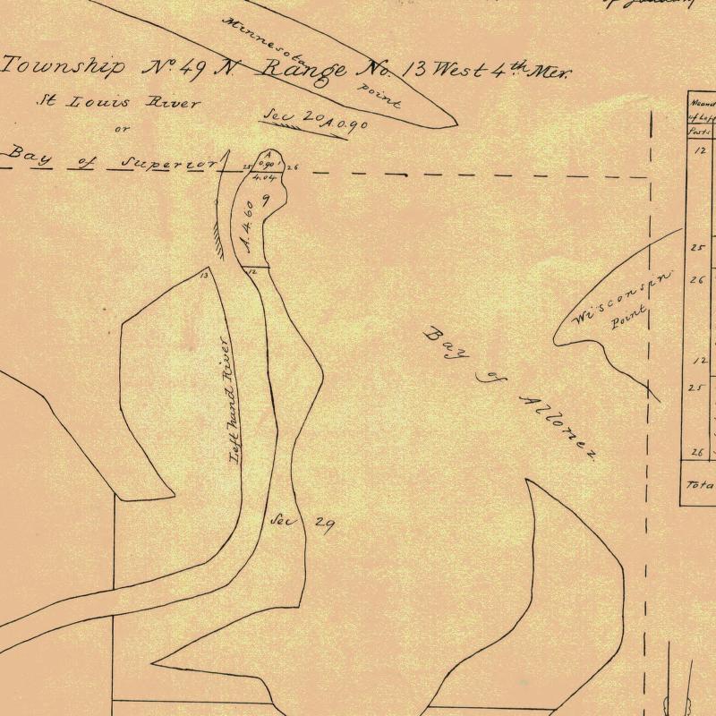
Detail of Minnesota Point from Stuntz’s Exterior Field Notes (August-October of 1852).
“In 1853 I got the range subdivided, and also in Superior, townsite 49, range 13. During the same year, later, in my absence, there came parties from the copper district of upper Michigan and located claims upon the range. They were principally miners. During the same year I built a residence on Minnesota Point under treaty license before the territory was sold to the Government. At that time there were only missionaries or license traders in the tract, as it belonged to the original Indian territory. In 1852, at Fond du Lac, there was a trading post and warehouse, in which I stored my goods on my arrival. In the fall of 1853 I bought three yoke of cattle and two cows at St. Croix Falls and brought them to the mouth of the Iron river, and had to cut a road thirty miles through the dense forest so as to get the oxen, cows and cart through. Later in the fall of 1853 I came through with an extra yoke of oxen, buying provisions, etc., and on coming up to Superior I found quite a settlement of log cabins. These settlers were anxious to get to the United States land office, then at Hudson, Wis. A dense forest intervened. We organized a volunteer company in January, 1854, to cut a road from old Superior to the nearest lumber camp on the St. Croix river, I furnishing two barrels of flour, provisions, pony and dog train, necessary to carry the provisions for a gang of seventeen men. The road was completed in twenty days, the snow being at that time two feet deep. This cut through a direct road to Taylor’s Falls and Stillwater. In 1854 I completed a mill on the Iron river and employed a man to superintend it, and I remained at Minnesota Point, my trading post, where I had first taken out the license. In the same year I took a contract to subdivide two townships located in Superior, townships 48-49, range 15, and afterward I attended the treaty at the time the Indians sold this country to the Government.
Before the 1854 Treaty of La Pointe could be ratified in Washington, D.C., the oral description agreed upon during the negotiations for exterior boundaries of the Chippewa treaties had to be surveyed with the tribe, documented, and delivered to Washington, D.C. before 1855. It is not clear who was involved with the exterior boundaries of these reservations; whether it was Stuntz, Barber, and/or others from their party.
“There were 5,000 Indians present with their chiefs. It was the biggest assemblage of Indians ever held at Lake Superior at this period of the country’s history. It took a month to pacify the troubles that grew among the different tribes in regard to their proportionate rights. This treaty was sent to congress September [30], 1854, and was ratified and became law in January, 1855.
To be continued in 1854…
In the Fall of 1850, the Lake Superior Ojibwe (Chippewa) bands were called to receive their annual payments at Sandy Lake on the Mississippi River. The money was compensation for the cession of most of northern Wisconsin, Upper Michigan, and parts of Minnesota in the treaties of 1837 and 1842. Before that, payments had always taken place in summer at La Pointe. That year they were switched to Sandy Lake as part of a government effort to remove the entire nation from Wisconsin and Michigan in blatant disregard of promises made to the Ojibwe just a few years earlier.
There isn’t enough space in this post to detail the entire Sandy Lake Tragedy (I’ll cover more at a later date), but the payments were not made, and 130-150 Ojibwe people, mostly men, died that fall and winter at Sandy Lake. Over 250 more died that December and January, trying to return to their villages without food or money.

George Warren (b.1823) was the son of Truman Warren and Charlotte Cadotte and the cousin of William Warren. (photo source unclear, found on Canku Ota Newsletter)
If you are a regular reader of Chequamegon History, you will recognize the name of William Warren as the writer of History of the Ojibway People. William’s father, Lyman, was an American fur trader at La Pointe. His mother, Mary Cadotte was a member of the influential Ojibwe-French Cadotte family of Madeline Island. William, his siblings, and cousins were prominent in this era as interpreters and guides. They were people who could navigate between the Ojibwe and mix-blood cultures that had been in this area for centuries, and the ever-encroaching Anglo-American culture.
The Warrens have a mixed legacy when it comes to the Sandy Lake Tragedy. They initially supported the removal efforts, and profited from them as government employees, even though removal was completely against the wishes of their Ojibwe relatives. However, one could argue this support for the government came from a misguided sense of humanitarianism. I strongly recommend William W. Warren: The Life, Letters, and Times of an Ojibwe Leader by Theresa Schenck if you are interested in Warren family and their motivations. The Wisconsin Historical Society has also digitized several Warren family letters, and that’s what prompted this post. I decided to transcribe and analyze two of these letters–one from before the tragedy and one from after it.
The first letter is from Leonard Wheeler, a missionary at Bad River, to William Warren. Initially, I chose to transcribe this one because I wanted to get familiar with Wheeler’s handwriting. The Historical Society has his papers in Ashland, and I’m planning to do some work with them this summer. This letter has historical value beyond handwriting, however. It shows the uncertainty that was in the air prior to the removal. Wheeler doesn’t know whether he will have to move his mission to Minnesota or not, even though it is only a month before the payments are scheduled.
Sept 6, 1850
Dear Friend,
I have time to write you but a few lines, which I do chiefly to fulfill my promise to Hole in the Day’s son. Will you please tell him I and my family are expecting to go Below and visit our friends this winter and return again in the spring. We heard at Sandy Lake, on our way home, that this chief told [Rev.?] Spates that he was expecting a teacher from St. Peters’ if so, the Band will not need another missionary. I was some what surprised that the man could express a desire to have me come and live among his people, and then afterwards tell Rev Spates he was expecting a teacher this fall from St. Peters’. I thought perhaps there was some where a little misunderstanding. Mr Hall and myself are entirely undecided what we shall do next Spring. We shall wait a little and see what are to be the movements of gov. Mary we shall leave with Mr Hall, to go to school during the winter. We think she will have a better opportunity for improvement there, than any where else in the country. We reached our home in safety, and found our families all well. My wife wishes a kind remembrance and joins me in kind regards to your wife, Charlotte and all the members of your family. If Truman is now with you please remember us to him also. Tomorrow we are expecting to go to La Pointe and take the Steam Boat for the Sault monday. I can scarcely realize that nine years have passed away since in company with yourself and Pa[?] Edward[?] we came into the country.
Mary is now well and will probably write you by the bearer of this.
Very truly yours
L. H. Wheeler
 By the 1850s, Young Hole in the Day was positioning himself to the government as “head chief of all the Chippewas,” but to the people of this area, he was still Gwiiwiizens (Boy), his famous father’s son. (Minnesota Historical Society)
Samuel Spates was a missionary at Sandy Lake. Sherman Hall started as a missionary at La Pointe and later moved to Crow Wing.
Mary, Charlotte, and Truman Warren are William’s siblings.
The Wheeler letter is interesting for what it reveals about the position of Protestant missionaries in the 1850s Chequamegon region. From the 1820s onward, the American Board of Commissioners for Foreign Missions sent missionaries, mostly Congregationalists and Presbyterians from New England, to the Lake Superior Country. Their names, Wheeler, Hall, Ely, Boutwell, Ayer, etc. are very familiar to historians, because they produced hundreds of pages of letters and diaries that reveal a great deal about this time period.

Leonard H. Wheeler (Wisconsin Historical Society)
Ojibwe people reacted to these missionaries in different ways. A few were openly hostile, while others were friendly and visited prayer, song, and school meetings. Many more just ignored them or regarded them as a simple nuisance. In forty-plus years, the amount of Ojibwe people converted to Protestantism could be counted on one hand, so in that sense the missions were a spectacular failure. However, they did play a role in colonization as a vanguard for Anglo-American culture in the region. Unlike the traders, who generally married into Ojibwe communities and adapted to local ways to some degree, the missionaries made a point of trying to recreate “civilization in the wilderness.” They brought their wives, their books, and their art with them. Because they were not working for the government or the Fur Company, and because they were highly respected in white-American society, there were times when certain missionaries were able to help the Ojibwe advance their politics. The aftermath of the Sandy Lake Tragedy was such a time for Wheeler.
This letter comes before the tragedy, however, and there are two things I want to point out. First, Wheeler and Sherman Hall don’t know the tragedy is coming. They were aware of the removal, and tentatively supported it on the grounds that it might speed up the assimilation and conversion of the Ojibwe, but they are clearly out of the loop on the government’s plans.
Second, it seems to me that Hole in the Day is giving the missionaries the runaround on purpose. While Wheeler and Spates were not powerful themselves, being hostile to them would not help the Ojibwe argument against the removal. However, most Ojibwe did not really want what the missionaries had to offer. Rather than reject them outright and cause a rift, the chief is confusing them. I say this because this would not be the only instance in the records of Ojibwe people giving ambiguous messages to avoid having their children taken.
Anyway, that’s my guess on what’s going on with the school comment, but you can’t be sure from one letter. Young Hole in the Day was a political genius, and I strongly recommend Anton Treuer’s The Assassination of Hole in the Day if you aren’t familiar with him.

I read this as “passed away since in company with yourself and Pa[?] Edward we came into the country.” Who was Wheeler’s companion when a young William guided him to La Pointe? I intend to find out and fix this quote. (from original in the digital collections of the Wisconsin Historical Society)
In 1851, Warren was in failing health and desperately trying to earn money for his family. He accepted the position of government interpreter and conductor of the removal of the Chippewa River bands. He feels removing is still the best course of action for the Ojibwe, but he has serious doubts about the government’s competence. He hears the desires of the chiefs to meet with the president, and sees the need for a full rice harvest before making the journey to La Pointe. Warren decides to stall at Lac Courte Oreilles until all the Ojibwe bands can unite and act as one, and does not proceed to Lake Superior as ordered by Watrous. The agent is getting very nervous.
 Clement and Paul (pictured) Hudon Beaulieu, and Edward Conner, were mix-blooded traders who like the Warrens were capable of navigating Anglo-American culture while maintaining close kin relationships in several Ojibwe communities. Clement Beaulieu and William Warren had been fierce rivals ever since Beaulieu’s faction drove Lyman Warren out of the American Fur Company. (Photo original unknown: uploaded to findadagrave.com by Joan Edmonson)
For more on Cob-wa-wis (Oshkaabewis) and his Wisconsin River band, see this post.
“Perish” is what I see, but I don’t know who that might be. Is there a “Parrish”, or possibly a “Bineshii” who could have carried Watrous’ letter? I’m on the lookout. (from original in the digital collections of the Wisconsin Historical Society)
Aug 9th 1851
Friend Warren
I am now very anxiously waiting the arrival of yourself and the Indians that are embraced in your division to come out to this place.
Mr. C. H. Beaulieu has arrived from the Lake Du Flambeau with nearly all that quarter and by an express sent on in advance I am informed that P. H. Beaulieu and Edward Conner will be here with Cob-wa-wis and they say the entire Wisconsin band, there had some 32 of the Pillican Lake band come out and some now are in Conner’s Party.
I want you should be here without fail in 10 days from this as I cannot remain longer, I shall leave at the expiration of this time for Crow Wing to make the payment to the St. Croix Bands who have all removed as I learn from letters just received from the St. Croix. I want your assistance very much in making the Crow Wing payment and immediately after the completion of this, (which will not take over two days[)] shall proceed to Sandy Lake to make the payment to the Mississippi and Lake Bands.
The goods are all at Sandy Lake and I shall make the entire payment without delay, and as much dispatch as can be made it; will be quite lots enough for the poor Indians. Perish[?] is the bearer of this and he can tell you all my plans better then I can write them. give My respects to your cousin George and beli[e]ve me
Your friend
J. S. Watrous
W. W. Warren Esq.}
P. S. Inform the Indians that if they are not here by the time they will be struck from the roll. I am daily expecting a company of Infantry to be stationed at this place.
JSW
