Bishop Baraga Crosses Lake Superior
February 18, 2025
Collected & edited by Amorin Mello

Bishop Irenaeus Frederic Baraga
~ Madeline Island Museum
This post features oral legends recorded about two of Bishop Irenaeus Frederick Baraga’s traverses from La Pointe across Lake Superior:
A) to Minnesota’s Cross River by canoe.
B) to Michigan’s Ontonagon River by ice.
In chronological order of publication, the first record was from a German traveloguer, the next two were from Catholic missionaries, and the last two were from Bad River tribal members.
- Kitchi-Gami, by Johann Georg Kohl, 1859/1860.
- Life and Labors of Bishop Baraga, by Rev. Chrysostom Verwyst, 1896.
- Life and Labors of Rt. Rev. Frederick Baraga, by Rev. Verwyst, 1900.
- Chippewa Indian Historical Project, by United States WPA, 1936-1942.
- Chippewa Indian Historical Project, by United States WPA, 1936-1942.

Originally published in German as
Kitschi-Gami; Oder, Erzählungen Vom Obern See
by Johann Georg Kohl, 1859.
Translated and republished in English as
Kitch-Gami: Wanderings Round Lake Superior,
By Johann Georg Kohl, 1860,
Pages 180-183.

German traveloguer
Johann Georg Kohl
Du Roy: “Do you known the summer voyage our most reverend friend, your companion, once made in a birch-bark canoe right across Lake Superior? Ah! that is a celebrated voyage, which everybody round the lake is acquainted with. Indeed, there is hardly a locality on the lake which is not connected with the history of his life, either because he built a chapel there, or wrote a pious book, or founded an Indian parish, or else underwent danger and adventures there, in which he felt that Heaven was protecting him.
“The aforesaid summer voyage, which I will tell you here as companion to his winter journey, was as follows:
“He was staying at that time on one of the Islands of the Apostles, and heard that his immediate presence was required at one of the little Indian missions or stations on the northern shore of the lake. As he is always ready to start at a moment, he walked with his breviary in his hand, dressed in his black robe, and with his gold cross fastened on his breast – he always travels in this solemn garb, on foot or on horseback, on show-shoes or in a canoe – he walked, I say, with his breviary in his hand and his three-corned hat on his head, into the hut of my cousin a well-known Voyageur, and said to him: ‘Dubois, I must cross the lake, direct from here to the northern shore. Hast thou a boat ready?’
” ‘My boat is here,’ said my cousin, ‘but how can I venture to go with you straight across the lake? It is seventy miles, and the weather does not look very promising. No one ever yet attempted this “traverse” in small boats. Our passage to the north shore is made along the coast, and we usually employ eight days in it.’
” ‘Dubois, that is too long; it cannot be. I repeat it to thee. I am called. I must go straight across the lake. Take thy paddle and “couverte,” and come!’ And our reverend friend took his seat in the canoe, and waited patiently till my obedient cousin (who, I grant, opened his eyes very wide, and shook his head at times) packed up his traps, sprang after him and pushed the canoe on the lake.
“Now you are aware, monsieur, that we Indians and Voyageurs rarely make greater traverses across the lake than fifteen miles from cape to cape, so that we may be easily able to pull our boats ashore in the annoying caprices of our weather and water. A passage of twenty-five or thirty miles we call a ‘grand traverse,’ and one of seventy miles is a impossibility. Such a traverse was never made before, and only performed this once. My cousin, however, worked away obediently and cheerfully, and they were soon floating in their nutshell in the middle of the lake like a loon, without compass and out of sight of land. Very soon, too, they had bad weather.
“It began to grow stormy, and the water rose in high waves. My cousin remarked that he had prophesied this, but his pious, earnest passenger read on in his breviary quietly, and only now and then addressed a kind word of encouragement to my cousin, saying that he had not doubted his prophecy about the weather, but he replied to it that he was called across the lake, and God would guide them both to land.
“They toiled all night through the storm and waves, and, as the wind was fortunately with them, they moved along very rapidly, although their little bark danced like a feather on the waters. The next morning they sighted the opposite shore. But how? With a threatening front. Long rows of dark rocks on either side, and at their base a white stripe, the dashing surf of the terribly excited waves. There was no opening in there, no haven, no salvation.
” ‘We are lost, your reverence,’ my cousin said, ‘for it is impossible for me to keep the canoe balanced in those double and triple breakers; and a return is equally impossible, owing to the wind blowing so stiffly against us.’
” ‘Paddle on, dear Dubois – straight on. We must get through, and a way will offer itself.’
“My cousin shrugged his shoulder, made his last prayers, and paddled straight on, he hardly knew how. Already they heard the surf dashing near them; they could no longer understand what they said to each other, owing to the deafening noise, and my cousin slipped his couverte from his shoulders, so as to be ready for a swim, when, all at once, a dark spot opened out in the white edge of the surf, which soon widened. At the same time the violent heaving of the canoe relaxed, it glided on more tranquilly, and entered in perfect safety the broad mouth of a stream, which they had not seen in the distance, owing to the rocks that concealed it.
” ‘Did I not say, Dubois, that I was called across, that I must go, and that thou wouldst be saved with me? Let us pray!’ So the man of God spoke to the Voyageur after they had stepped ashore, and drawn their canoe comfortably on the beach. They then went into the forest, cut down a couple of trees, and erected a cross on the spot where they landed, as a sign of their gratitude.
“Then they went on their way to perform their other duties. Later, however, a rich merchant, a fur trader, came along the same road, and hearing of this traverse, which had become celebrated, he set his men to work, and erected at his own expense, on the same spot, but on a higher rock, a larger and more substantial cross, which now can be seen a long distance on the lake, and which the people call ‘the Cross of —–‘s Traverse.’”

Historical Collections and Researches of Michigan Pioneer and Historical Society: Vol. XXVI,
by Michigan State Historical Society, 1896,
pages 541-542.
LIFE AND LABORS OF BISHOP BARAGA
A short sketch of the life and labors of Bishop Baraga
The Great Indian Apostle of the Northwest.
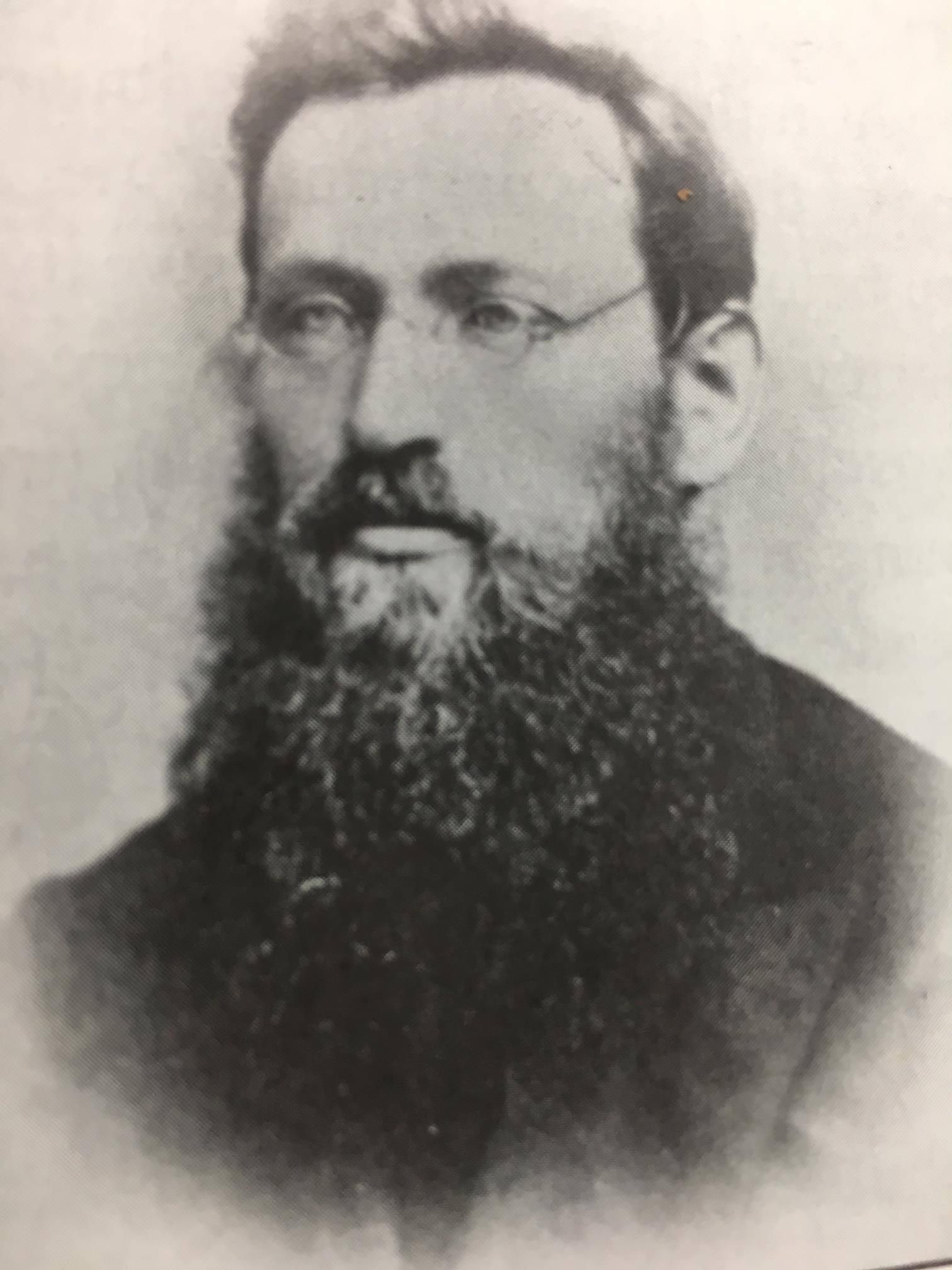
By Rev. Chrysostom Verwyst O.S.F. of Ashland, Wis.
Father John Chebul arrived on Lake Superior at the Sault in October 1859 to assist his fellow Slovanian Bishop Baraga. Chebul spent the winter at Ontonagon with miners before arriving at La Pointe in May 1860.
On another occasion Father Baraga went to Ontonagon from La Pointe. We will relate the incident as told to the writer by Rev. John Cebul, of Newberry, Mich. He was well acquainted with Bishop Baraga, being a fellow countryman who had been sent to La Pointe in 1860, where he labored amongst the Chippewas of that island and Bayfield, Bad River Reserve, Superior and other places, for about thirteen years, being universally loved and esteemed by all. He says:
Bishop Baraga was intending to go on the ice to Ontonagon. He was accompanied by a man from the island. The reason they took to the ice was because it was much nearer and the walking a great deal better than on the main land. During March and April the ice on Lake Superior becomes honey-combed and rotten. If a strong wind blows, it cracks and moves from the shore if the wind blows from the land. Such fields of ice does not notice that he is in danger till he comes to the edge of the ice and then to his horror discovers a large expanse of open water between him and the mainland. Should the ice float out towards the middle of the lake or break up, he is lost. Father Baraga and his companion had traveled on the ice for some time, thinking all was right. All at once they came to the edge of the ice and saw it was impossible to reach land, as the wind had driven the ice from the shore out into the Lake. His companion became greatly alarmed. Father Baraga remained calm, praying, no doubt, fervently to Him who alone could save them. Finally the wind changed and drove the cake of ice on which they were floating to the shore. They landed at Cadotte point, about 20 or 30 miles from Ontonagon, having been carried by the wind on their ice raft about sixty miles. “See,” said the good priest to his companion, “we have traveled a great distance and yet have not labored.” It seems the good God wanted to save the saintly missionary a long and painful walk, by giving him a ride of sixty miles on a cake of ice.

Life and labors of Rt. Rev. Frederic Baraga
by P. Chrysostomus Verwyst, 1900,
pages 219-222.
“Louis Gaudin“ was one of several legendary children born to Jean Baptiste Gaudin, Sr. and Awenishen (a sister of Hole-in-the-day):
– Antoine Gordon
– Elizabeth (Gordon) Belanger
– Louison Gordon, Sr.
– Harriet (Gordon) Lemon
– John Baptiste Gordon, Jr.
– Angelique Gordon
– Joseph GordonLouison Gordon, Sr. (1814-1899) married Julia Brebant, whose sisters were married to Henry Bresette and Judge John W. Bell.Wizon is an objibwecized form of the francophone name Louison.
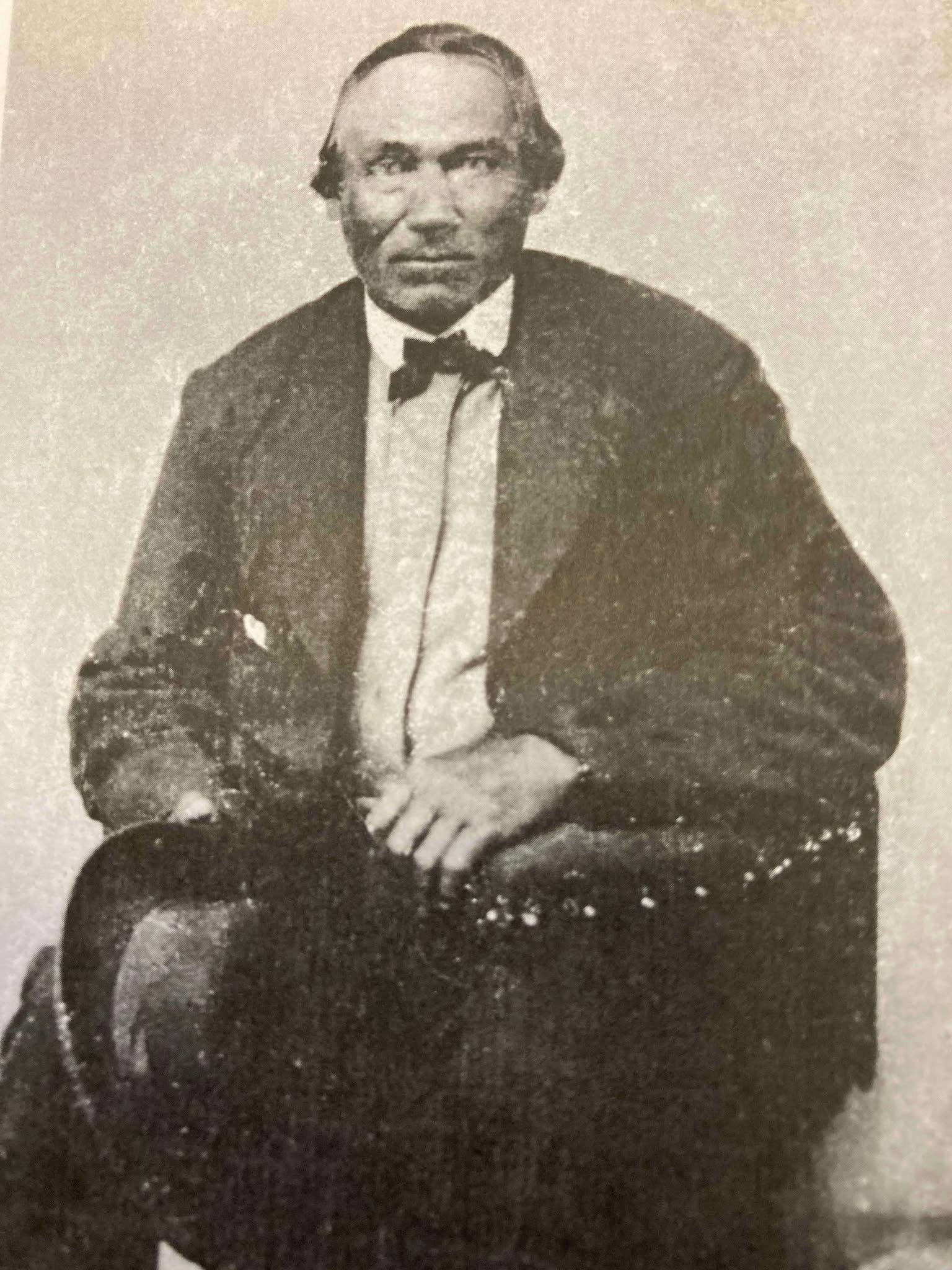
Undated photo from the Gordon Museum thought to be a brother of Antoine Gordon:
possibly Louis Gordon?

Chippewa Entrepreneur
Antoine Gordon
~ Noble Lives of a Noble Race (pg. 207) published by the St. Mary’s Industrial School in Odanah, 1909.
We learn from F. Baraga’s letter, written in October, 1845, that he intended to go to Grand Portage, Minn., the next fall to build a church there. It is, therefore, highly probable that he made that trip in the fall of 1846. He first went to La Pointe, where, no doubt, he spent some time attending to the spiritual wants of the good people. He then engaged a half-breed Indian, named Louis Gaudin, to go with him to Grand Portage. They had but a small fishing boat with a mast and sail, without keel or centre-board. Such a boat might do on a river or small lake, but would be very unsafe on a large lake, where it would easily founder or be driven lake a cork before the wind. The boat was but eighteen feet long. When they started from La Pointe, the people laughed at them for attempting to make the journey. They said it would take them a month to make the voyage, as they would have to keep close to the shore all the way, going first west some seventy miles to the end of the lake and then, doubling, turn northward, coasting along the northern shore of Lake Superior. this would make the distance about two hundred miles, perhaps even more.
However, Father Baraga and his guide set out on their perilous journey. At Sand Island they awaited a favorable wind to cross the lake, which is about forty miles wide at that place. By so doing they would save from eight to one hundred miles, but would expose themselves to great danger, as a high wind might arise, whilst they were out on the open lake, and engulf their frail bark.
They set sail on an unusually calm day. Father Baraga steered and Louis rowed the boat. Before they got midway a heavy west wind arose and the lake grew very rough. They were constantly driven leeward and when they finally reached the north shore they were at least thirty miles east of their intended landing place, having made a very perilous sail of seventy miles during that day.
While in the height of the storm, in mid-ocean, it might be said, Louis became frightened and exclaimed in Chippewa to the Father, who was lying on his back in the boat, reciting his office in an unconcerned manner: “Nosse, ki ga-nibomin, gananbatch” – Father, perhaps we are going to perish!” The Father answered quietly: “Kego segisiken, Wizon” (Chippewa for Louis) – “Don’t be afraid, Wizon; the priest will not die in the water. If he died here in the water the people on the other shore, whither we are going, would be unfortunate.”
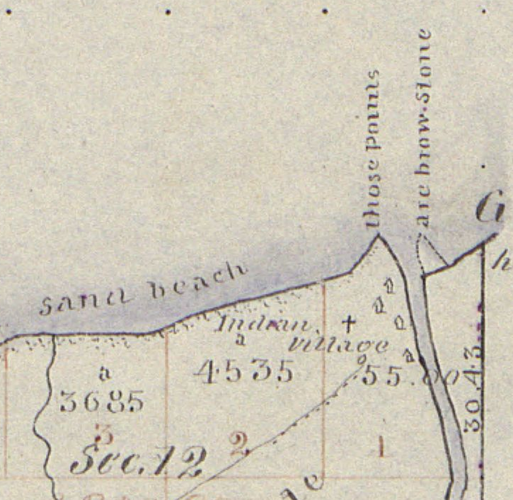
When nearing the north shore the danger was even greater than out on the open water, for there were huge breakers ahead. Louis asked the Father whither to steer, and, as if following a certain inspiration, F. Baraga told him to steer straight ahead for the land. Through a special disposition of Divine Providence watching over the precious life of the saintly missionary, they passed through the breakers unharmed and ran their boat into the mouth of a small river, heretofore unnamed, but now called Cross River.
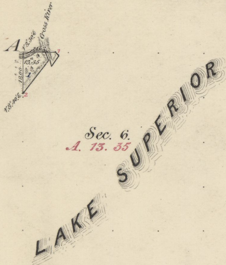
1859 PLSS detail of trees at the mouth of “Cross River”.
Full of gratitude for their miraculous escape, they at once proceeded to erect a cross. Hewing a tree in a rough manner, they cut off the top as far up as they could reach, and taking a shorter piece, they nailed it cross-wise to the tree. “Wizon,” said the Father, “let us make a cross here that the Christian Indians may know that the priest coming from La Pointe landed here.” The cross was, it is true, unartistic, but it was emblem of their holy faith and it gave the name, Tchibaiatigo-Sibi, “Cross River,” to the little stream where they landed.
They arrived none too soon. Ascending an eminence and looking out on the immense lake they saw that the storm was increasing every moment; high waves with white caps, which would surely have engulfed their little bark. They landed about six o’clock in the evening. Having spent the night there, they continued their journey next day, and in two days arrived at Grand Portage, having made the whole journey in three days. May we not think with Louis Gaudin that their safe passage across the stormy lake, and their deliverance from a watery grave, was due to a special intervention of Divine Providence in favor of the saintly missionary?

Missionary Labors of Fathers Marquette, Menard and Allouez, in the Lake Superior Region by Rev. Chrysostom Verwyst of Bayfield, 1886.
In 1667 Father Claude Allouez, S. J., then stationed at the mission of the Holy Ghost at the head of Chequamegon Bay, made the voyage across the lake from Sand Island. He made the voyage in a birch-canoe with three Indians. He remarks that they paddled their canoe all day as hard as they could without intermission, for fear of losing any of the beautiful calm weather they had. It took them twelve hours to make the trip across. The Father was then on his way to visit some Christian Indians residing at Lake Nipigon – “Animibigong” in Chippewa. For the particulars of this journey we refer the reader to “Missionary Labors of Fathers Marquette, Allouez, and Menard in the Lake Superior Region.”
The following narrative is not to be found in any of Baraga’s published letters, but the writers has it from the mouth of trustworthy persons, among whom is Father Chebul, a countryman of F. Baraga, who was stationed at Bayfield for many years. We will give the account, as we have it from Rev. F. Chebul.
Francois Newago, Sr. is the “man named Newagon” from Madeline Island, as his children were still young teenagers then.One time F. Baraga was going to Ontonagon in company with an Indian half-breed in the month of March or April. At that season of the year the ice, though thick, becomes honey-combed and rotten. Some say that Baraga’s companion was a man named Newagon. They went on the ice at La Pointe Island. As the walking on the sandy beach would have been very fatiguing and long, they determined to make straight for Ontonagon over the ice. By so doing they would not only have better walking, but also shorten their way a great deal.
A strong southwest wind was blowing at the time, and the ice, becoming detached from the shore, began drifting lakeward. After they had traveled for some time, they became aware of what hat happened, for they could see the blue waters between them and the shore. Newagon became greatly alarmed, for almost certain death stared them in the face. Had the wind continued blowing in the same direction, the ice would have been driven far out into the lake and broken up into small fragments. They would surely have perished.
To encourage the drooping spirit of his companion, F. Baraga kept telling him that they would escape all right and that they must trust in God, their loving Father and Protector. He also sang Chippewa hymns to divert Newagon’s attention and calm his excitement. Finally the wind shifted and blew the field of ice back towards the shore.
1847 PLSS detail of brownstone points, village, cross, and trailhead at the mouth of Iron River.
“Cadotte Point, near Union Bay“
appears to be located at what is now Silver City at the mouth of Iron River and eastern trailhead to the Porcupine Mountains.Michel Cadotte, Sr. ran a trading post by the Old French Fort on Madeline Island around 1800 and smaller stations scattered along the Wisconsin / Michigan shoreline of Lake Superior. Cadotte first worked for the British North West Company and later the American Fur Company after The War of 1812.They landed near Cadotte Point, near Union Bay, a short distance from Ontonagon, which they reached that same day. “See,” said the missionary to his companion, “we have traveled a great distance and have worked little.” The distance from La Pointe to Ontonagon is about sixty or seventy miles by an air line. Had they been obliged to walk the whole distance around the bend of the lake, it would probably have taken them two or three days of very hard and fatiguing traveling. So what at first seemed to threaten certain death was used by God’s fatherly providence to shorten and facilitate the saintly priest’s journey.
United States. Works Progress Administration:
Chippewa Indian Historical Project Records 1936-1942
(Northland Micro 5; Micro 532)
Reel 1, Envelop 3, Item 5
BISHOP BARAGA’S TRIP TO ONTONAGON
As related by William Obern to John Teeple.
Francois Belanger, Sr.
and Elizabeth (Gordon) Belanger. The Belanger Settlement was founded by their son Frank Belanger, Jr. and Elizabeth (Morrow) Belanger.
The journey I am about to describe is taken from the many experiences of Bishop Baraga, which were related to me by my grandfather. It deals with a journey made at an almost impossible time for ice travel on any of the Great Lakes, and portrays the important part the elements can play in a man’s life, for good or bad, for weal or for woe, as well as Bishop Baraga’s unfaltering confidence in Divine Providence.
The season of the year in which this incident took place was in the spring – along in April. Bishop Baraga and his faithful guide, Louis Gordon, started from LaPointe enroute to Ontonagon, Michigan, a distance of some eighty or ninety miles from LaPointe, straight across as the crow flies over the frozen water of Lake Superior. Dogs were used to a very large extent in those days for the purpose of transportation.
On account of the prevailing soft weather, the ice on the lake was not very solid, and with the right kind of wind, a general break-up was apt to occur at any time. In this instance, when the Bishop and his guide were about ten miles from LaPointe a south-west wind began to blow, increasing in velocity with each passing hour. The ice broke away from the shore, and began drifting outward into the open waters of Lake Superior, carrying its passengers with it. The guide, seeing the danger, suggested to the Bishop that they land on one of the islands, but the Bishop told him not to worry and to keep going in the direction of Ontonagon; that with the help of God they would reach their destination in safety.
With the coming of night the wind increased, and the two travelers were drifting out into the open waters with considerable speed. Soon the mainland was lost to view, and the guide knew that to remain on the ice mean ultimate death by freezing or drowning, but it was too late to do anything now. They had passed up the opportunity of getting off.
The missionary told Louis to look out for the dogs, and after taking a lunch, he wrapped himself up and went to sleep. He advised the guide to do likewise. The guide wrapped himself up, but he did not sleep. He kept constant vigil; about midnight the wind changed, coming from the opposite direction.

Detail of Porcupine Mountains, Iron River and Ontonagon River on the Map of the Mineral Lands Upon Lake Superior Ceded to the United States by the Treaty of 1842 With the Chippeway Indians, 1845.
The guide woke Bishop Baraga, telling him that the wind had changed. The priest asked his guide from what direction it was blowing, and upon being told that it was coming from the north-east remarked, “It is just what I hoped for and suspected.” He again told his guide to lie down and go to sleep, but the guide fearing that the plate of ice they were on might break up, would not sleep. They began to drift back almost in the same direction they had come, and when daylight came the outline of the Porcupine Mountains could be plainly seen in the distance. They were traveling at a very high rate of speed, and about mid afternoon they landed on the south shore of Lake Superior, one mile from Ontonagon, their destination.
“There,” said the bishop after they got off the ice and stepped on to the mainland, “this is just what I expected.”
At the time of this narrative, Ontonagon was a small settlement of Indians with but a few white men, who were engaged in the fur trade with the Indians and represented the American Fur Company.
* According to the description furnished by the guide, the piece of ice they were on was about one hundred by two hundred feet.
United States. Works Progress Administration:
Chippewa Indian Historical Project Records 1936-1942
(Northland Micro 5; Micro 532)
Reel 1, Envelop 3, Item 6
Cross River
ORIGIN OF THE NAME
Related by William Obern
To John Teeple.

Ojibwe, Activist, Priest
The Life of Father Philip Bergin Gordon, Tibishkogijik
by Tadeusz Lewandowski, 2019.
The story I am about to relate deals with an incident of one of the many experiences of Bishop Baraga. The narrative was related to me by my grandmother, Elizabeth Bellanger, who before her marriage was Elizabeth Gordon. She was a blood relative of Father Philip Gordon. The Gordon family consisted of the parents; sons, John, Louis and Antoine, and daughters My grandmother (Elizabeth) and Angelique.
Louis Gordon acted as the guide and all-around servant of Bishop Baraga, the missionary priest. The latter had a very large territory to cover; the northern and southern shores of Lake Superior, thence to the Dakotas and down to the waters known as Chippewa River, which emptied into the Mississippi below St. Paul.
Louis Gordon, the guide, (my grand-uncle) told of many of the experiences he had on these trips with Bishop Baraga. In speaking of my grand-uncle, Louis Gordon, I wish to state first, upon my honor as a gentleman, that he was a Christian in every sense of the word; he never took a drink of intoxicating liquor in his life; and never used profane language.
The stories related to me by my grandmother I well remember, and coming from a man like my grand-uncle, I believe them.
One day Bishop Baraga and his guide, Louis Gordon, started from LaPointe, on the western end of Lake Superior, near the place now known as Bayfield, on the shore of the lake, and about twenty-five miles from the present city of Ashland. At the time of this incident there were no white settlements to speak of at the western end of Lake Superior and the “head of the lakes” region. Bayfield, Washburn, Ashland, Superior and Duluth did not exist in those days. There were few white men among the Indians, and those few represented the American Fur Company. A few, mostly Frenchmen, had in former years settled in Minnesota and Wisconsin.
As formerly stated the trip started from LaPointe. It was to be made by water, and the boat used by the missionary and his guide, from the description given, could not have been more than 16 or 18 feet long. It was just large enough to accommodate the Bishop and his guide and to take care of their camping equipment, and although small, it came out the victor in many storms, proving itself quite seaworthy. These voyagers had a make-shift sail, which furnished them power when the wind was fair, probably a blanket which was raised on a pole; but in calm weather, or when the seas became too rough, the craft was usually propelled with oars. Wind and weather conditions in those days controlled lake travel largely, and when the lake became too rough and the seas too choppy, the voyageurs usually made a landing in some bay or stream outlet.
In this instance, the missionary and his guide were headed for Grand Marias, on the north shore of Lake Superior, a distance of fifty or fifty-five miles from the group of islands known as “Apostle Islands.” Leaving LaPointe, it was necessary for them to cross Lake Superior, traveling directly North. In the event of a severe storm, there is, of course, no place for shelter in the open waters of Lake Superior, and when once started it was necessary for them to continue their voyage until they reached Grand Marias, the point of their destination.
When the Bishop and his guide were about to leave the Apostle Islands, Louis Gordon, the guide, said to Bishop Baraga: “No-say,” (meaning father in Chippewa), “it would not be safe for us to cross the lake in this small boat today. The wind is from the south-west, and it is getting stronger. The lake will become very rough, the seas high, and I am afraid we may perish if we venture out in this wind. We had better not leave this island today, or else follow the south shore around to the end of the lake, so we can find a place to land should the seas become too rough.”
Bishop Baraga replied, “My son, have faith in God. Across that lake my Indians are waiting they must be expecting me, and it is my duty to get there as soon as possible. It would be a waste of time for us to go along the south shore, then along the north shore from the St. Louis River to Grand Marias, when we can cross here and save many miles of hard rowing and precious time. We will trust in God and make the crossing in safety.”
So, Louis Gordon, having unbounded faith in the Bishop, obeyed him, and they began their voyage across the lake, notwithstanding the fact that the wind was increasing in fury and the seas becoming higher and rougher with each passing moment. After they got into the open waters, the guide had considerable difficulty in manning the boat and keeping it from being swamped by the breaking seas. He stood up, and turning to Bishop Baraga said, “No-say, we will never reach the shore.” The Bishop was sitting at the stern of the boat, reciting his breviary. “Louis,” he said, “do not lose faith in God; fear not, He is with us.” The guide was kept busy in keeping the boat in its course, and bailing it out, to prevent it from being filled as the white caps would break over it. He headed it to a point west of Grand Marias in order that he might be better able to ride the crest of the seas, praying and hoping that when they reached the shore, which he hoped would be before dark, they would find a place to land in safety.
I wish to state here that I have seen the north shore of Lake Superior. After leaving Duluth, going east along the north shore, one will find a very rugged shore, ledges of rock from 20 to 200 feet in height standing perpendicularly along the shore line. In these rock ledges are great caves that have been fashioned by angry waves of Lake Superior during centuries. To fully appreciate this story it is well for the reader to know a little concerning the dangers of Lake Superior. Salt-water sailors who have been on the five oceans prefer to be on the ocean in a storm rather than on Lake Superior. The fact that Lake Superior is more dangerous than the oceans is conceded by sailors generally, particularly in the fall of the year. In the ocean, the billows are longer with great spaces between them; while on Lake Superior they are short, choppy, and heavy; and create much more hazard.
Night overtook the missionary and the guide before they reached the north shore; the wind became stronger and the billows higher. The only light they had to guide them was the distant glimmer of the stars, and the guide was able to keep his course by keeping his craft nosed in the direction of the North Star.
After many hours of hard pulling on the oars, the guide knew that they were reaching the shore because he was familiar with the shoreline, and knew that the noise which was all but deafening was created by the breakers dashing against the rock-bound shore.
The guide said to his companion, “No-say, we are nearing the shore, but I am sure we are many miles from Grand Marias. There is no river known in this region and on account of the precipitous formation of the shore line, we have no place to land in safety in this storm.” Bishop Baraga answered, “My son, do as I say, and we will make a landing in safety.” The guide obeyed. His hand were blistered; his strength was leaving his body, but he managed to keep up his struggle against the angry seas. The back-wash created by the billows dashing against the perpendicular rocks of the shore-line made conditions more perilous. The guide said, “Father, there is nothing but certain death ahead of us. We cannot survive this storm.” The noise was so great that it was impossible for the two voyagers to hear each other without shouting, though they were only fifteen or sixteen feet apart; but the Bishop simply said, “Louis, keep going straight ahead.”
Much water had entered their little boat, and it was coming in faster now that they were nearing the ledges of rocks, and the seas, augmented by the back-wash, were becoming rougher, so that destruction seemed imminent. Then amid the tumult and tossing of the boat upon the choppy seas, the boat was suddenly driven from the rough sea into tranquil waters, seemingly guided by some supernatural power. The guide knew that the craft was not being directed by his efforts, and that they were nearing the shore with each sweep of the waves. To his amazement, the boat grounded, and by feeling the depth of the water with his oar he knew that they were in shallow water, but he was unable to determine whether they were in a cave or at the mouth of some stream.
“Father,” Louis cried delightedly, “it seems to me that we are in a cave or at the mouth of some stream, because by feeling around with my oar I can feel a current coming from the land direction.” The missionary then told him to take out their bundle, and light the lantern so that they could see where they were and explore their surroundings.
After lighting the lantern, they made a survey of their surroundings and found that they were at the mouth of a large stream. They climbed out of the river and to higher ground, and there made their camp for the night.
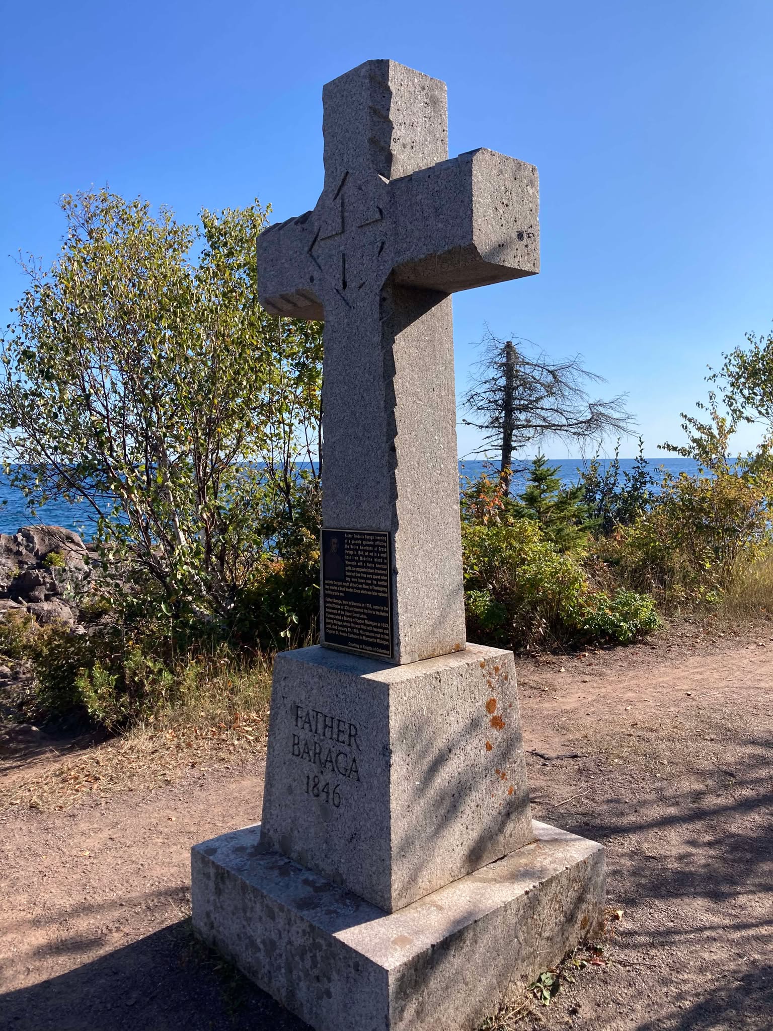
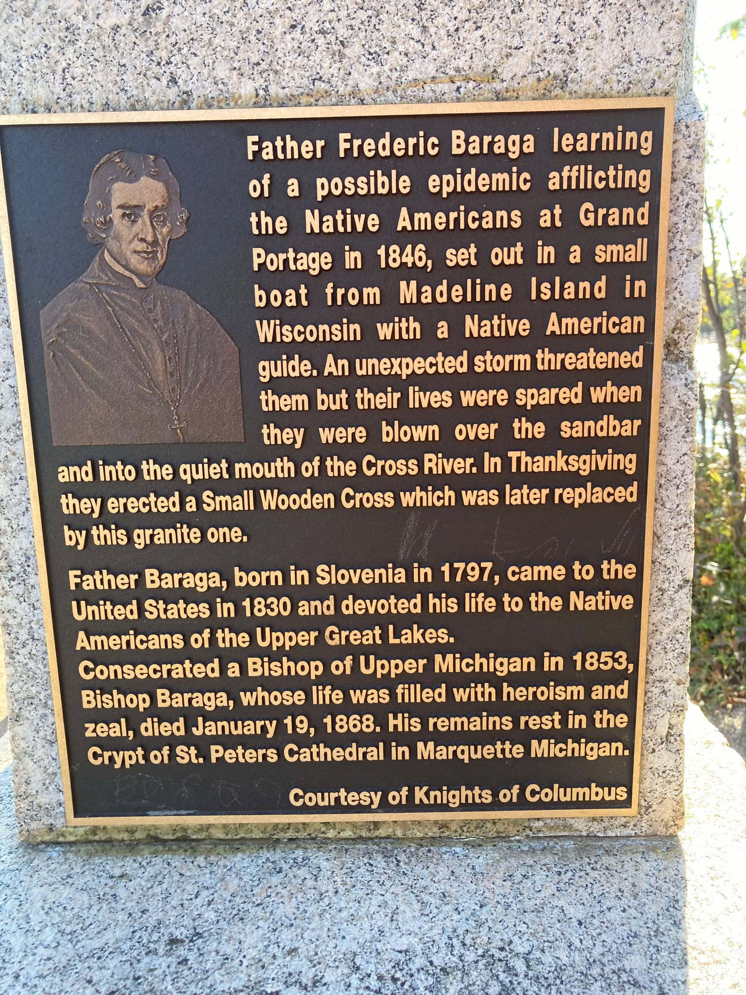
Cross River Historical Marker
Photo by Brian Finstad, 2024.
The following morning, Bishop Baraga told his guide that they would stay there that day, that they would construct and erect a cross in token of thanksgiving to God for his help and guidance to safety. So, all that day they worked. They cut down some large cedar trees and erected a large cedar cross, which they set up on the shore at the mouth of the stream. The next morning Bishop Baraga and his guide went down to the site of the cross they had erected, and again offered thanks to God for their safe deliverance. The missionary told his guide: “Hereafter this stream shall be known as “Cross River”. It has been thus known from that time on.
About twenty or twenty-five years ago, a large number of people from Duluth, Superior, and other towns and cities in the Lake Superior region, regardless of creed, made a trip to Cross River and erected a substantial cross there in place of the old cedar cross set up by Bishop Baraga and his guide, Louis Gordon, in thanksgiving to God for the wonderful guidance and loving care of his servants who landed safely at the mouth of this stream after such a perilous voyage.
Bishop Baraga stopped at Superior on their way back from the North Shore. They did not venture another lake-crossing. This zealous Lake Superior Chippewa Indian Missionary died at Marquette, Michigan, on January 19, 1868.
Cross River Historical Marker
Photo by Brian Finstad, 2024.
Barber Papers: “Apostle Islands” Summer of 1857
February 13, 2016
By Amorin Mello
Selected letters of the Joel Allen Barber Papers
… continued from the Spring of 1857.
This season (Summer of 1857) of the Barber Papers begins with this editorial commentary from Chequamegon History because the Barber Papers do not contain much information about events that occurred during this time period. Fortunately, letters from Giles Addison Barber preceding this season indicate that he had planned to take his second trip west from Vermont to Lake Superior in order to rejoin his son Joel Allen Barber during the Summer of 1857.
Giles’ first trip in the Spring of 1856 was tragically disrupted by the death of his first son Augustus Hamilton Barber, and was unprepared to reconcile Augustus’ unfinished copper claims, land speculations, and U.S. General Land Office survey contracts during that trip. The vocabulary Giles used to describe employees and politics at the U.S. General Land Office in Superior City were not admirable. Giles sought reconciliation by applying pressure upon national politicians in his social network (particularly Alvah Sabin; U.S. Representative from Vermont), and began preparations for this second trip.
Augustus Hamilton Barber had begun to work closely with George Riley Stuntz earlier in 1852 to survey the far northwestern region of the Wisconsin Territory; their most recent survey together before the Summer of 1857 had been at the Gardens in Odanah of the LaPointe Indian Reservation during the Fall of 1856. Stuntz’s nephew Albert Conrad Stuntz began surveying the Gogebic Iron Range of La Pointe County during the Summer of 1857. Lysander “Gray Devil” Cutler moved to Ironton during the Summer of 1857 as the new managing agent on the Gogebic Iron Range for the Wisconsin & Lake Superior Mining & Smelting Company to operate in collusion with Stuntz’s survey of the Gogebic Iron Range for the U.S. General Land Office.
“Mr. Cutler was appointed the managing agent of this prospective Wisconsin bonanza, at a fair salary, to which was added a liberal amount of the stock of the company. His first task was to perfect the title to the property, and the first step toward it was to take a personal view of the situation and the property. It was a somewhat arduous undertaking, not unfraught with danger. Excepting two or three traders and surveyors, who had stock in the company, the population, which consisted mostly of Indians and half-breeds, viewed this incursion of wealth-hunters from the lower lakes with suspicion and distrust. To add to the difficulties of the situation, other parties owning Sioux script were endeavoring to acquire a title to the mineral range. One man working in the interest of the company the year before, had been discovered, after being missed for some weeks, dead in the forest, near the range. Bruises and other indications of violence on the body gave strong ground for the belief that he had been murdered. Altogether it was a position, the applications for which were not numerous. His [Cutler’s] first trip was made in the Summer of 1857.”
~ History of Milwaukee, Wisconsin:
From Prehistoric Times to the Present Date
Milwaukee Genealogical Society, 1881, page 790.

“IN MEMORY OF
AUGUSTUS H. BARBER
of Cambridge, Vt. U.S. Deputy Surveyor
who was drowned in
Montreal River
Apr. 22. A.D. 1856
Aged 24 yrs. & 8 ms.”
~ FindAGrave.com
The death of this unnamed managing agent that Cutler replaced corresponds with the timing of Augustus’ death in the Spring of 1856. Augustus’ last letters reveal that he had gotten into “A Little Trouble“ and decided to “Let ‘Em Rip“ shortly before his death. Augustus was reported to have drowned below Superior Falls near Ironton and the Mouth of the Montreal River. However, a confidential letter written by Giles to Allen on the first year anniversary of Augustus’ death reveals that the location actually occurred further inland under secret circumstances:
“It must remain a sealed book to us, how Augustus was hurried out of the woods, and why it was so ordained if there, was any ordination about it, till we meet him in another world, which I devoutly hope we may do though I am sorry to say more hoping than expecting.”
Augustus is suspected to have been the unnamed managing agent found dead near the Gogebic Iron Range that Cutler replaced. There was a footpath between the Gogebic Iron Range and Ironton, which supports this speculation. James Smith Buck was an elected official of La Pointe County during the Summer of 1857, and wrote memoirs about working in the Penokee Survey Incidents with Cutler and Stuntz. Buck’s memoirs glorified another traumatic event at Ironton which involved Cutler and his management approach to disciplining the mining company’s Lake Superior Chippewa employees at these locations. Buck did not make any references to the Barbers in his memoirs; however, Asaph Whittlesey published a public retort to Buck’s memoirs with a cryptic allusion to “the Siege of Barlisle“. Whittlesey’s reference is suspected to have been about the murder of Augustus Hamilton Barber.
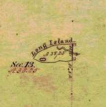
Detail of Chequamegon Point included in the Barber brother’s survey of T47N R4W during the Summer of 1855.
Without further speculation about how the Barber family may have been involved with the 1857 Stuntz/Cutler survey of the Gogebic Iron Range, the rest of this will be dedicated to the 1857 Barber survey of we can focus on the Barber brothers’ survey of what is now the Apostle Islands National Lakeshore.
Joel Allen Barber and his brother Augustus Hamilton Barber began their work to survey the Apostle Islands at Chequamegon Point on Long Island during the Summer of 1855. Augustus and Allen continued their survey of the Apostle Islands during the Winter of 1856:
“We shall go back in a few days and commence surveying around the islands. Now don’t fancy that we cannot survey in the winter, for we have tried it and know better.”
After Augustus’ death, Allen rewrote their original field notes of the Apostle Islands survey during the Winter of 1857, per instructions from their father:
“Keep a strict acct of all the expense of resurveying on the last winters contract, if you get a new one & undertake it, as I am informed that I can get relief from Congress by a special act, paying me all that it will cost to do the work over again, which will be as much for you interest as anybody’s of this please say nothing to any one.”
Allen then renewed their contract for this survey during the Spring of 1857, causing much anxiety for their father despite giving instructions to do this:
“I am surprised to learn that you are going to survey islands so late in the season. Nothing that I can now say will avail any thing else I would caution against trusting too long to the treacherous covering over the dark blue waters. I hope you will have good success and get through without any fatal accidents to your self or to any one of your party.”
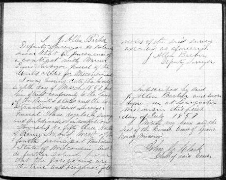
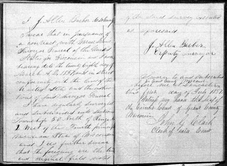
The Barbers’ survey field notes were finally accepted as complete by the U.S. General Land Office during this season; the Summer of 1857.
“… the survey of the Apostle Islands, in Lake Superior. The survey of those islands was executed by J. Allen Barber, deputy surveyor, with unusual care and trouble.”
~ Message of the President of the Untied States to the Two Houses of Congress at the Commencement of the Second Session of the Thirty-Fifth Congress, 1858, page 119.
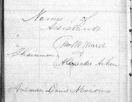
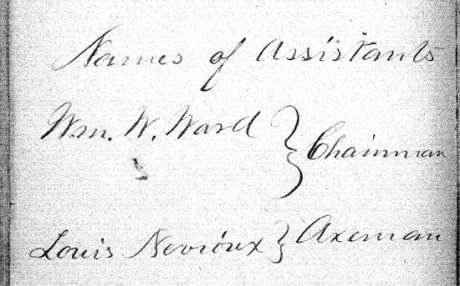
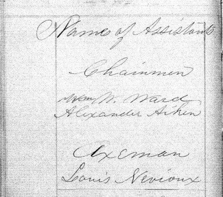
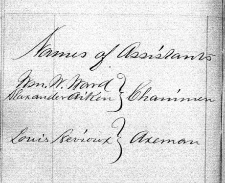
The following documents are the original surveys notes of the Apostle Islands as submitted by Deputy Surveyor Joel Allen Barber during the Summer of 1857. Augustus Hamilton Barber’s former role in these surveys during 1855 and 1856 was not mentioned anywhere in his brother’s survey notes. In lieu, Joel Allen Barber identified three assistants during these surveys:
- William W Ward
- Alexander Aiken
- Louis Nevioux
Aiken and Neveau are familiar surnames in Lake Superior Chippewa communities.
Our transcriptions of selected letters from the Joel Allen Barber Papers are continued below without further editorial commentary:
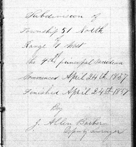
Exterior Field Notes
Township 51 North, Range 2 West
Township 52 North, Range 1 West
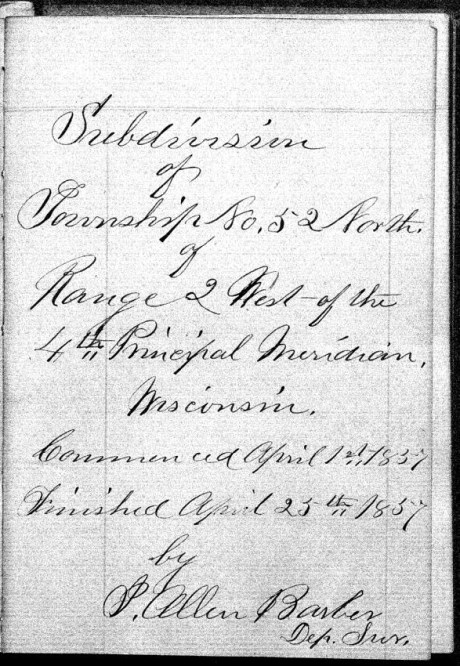
Township 52 North, Range 2 West
Township 53 North, Range 1 East
Township 53 North, Range 1 West
Township 53 North, Range 2 West
April 1857
Notebook ID: EXT27501
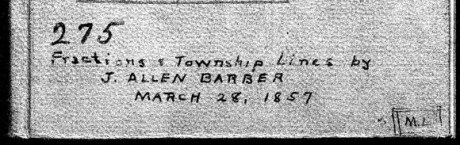
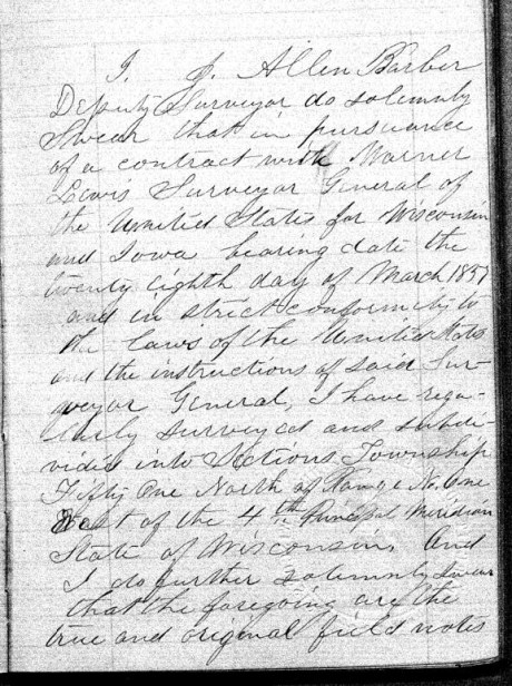
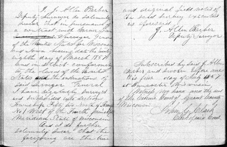
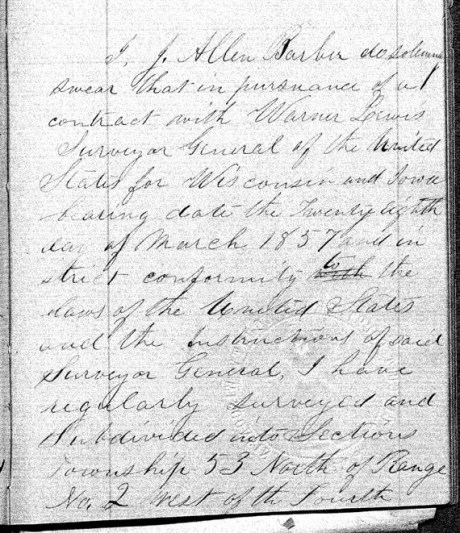
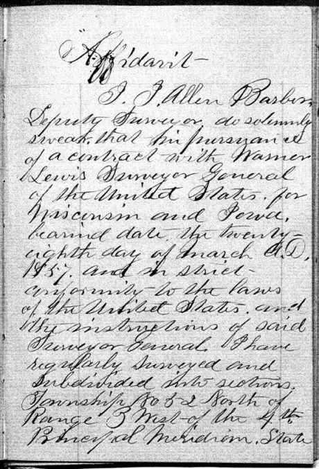
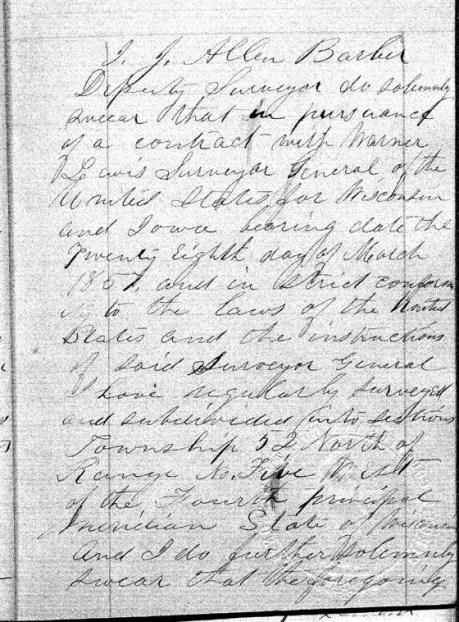
Joel Allen Barber received this survey contract on March 28th, 1857, from Warner Lewis at the General Land Office in Dubuque, Iowa.
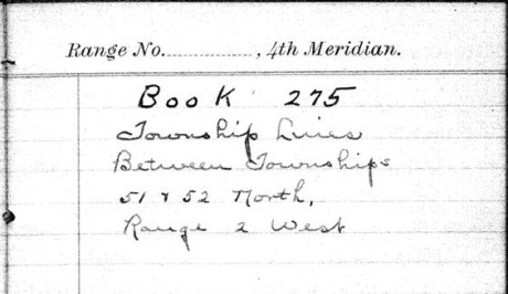
“Township Lines Between Townships 51 & 52 North, Range 2 West”
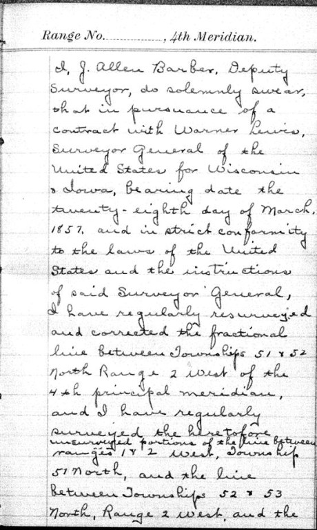
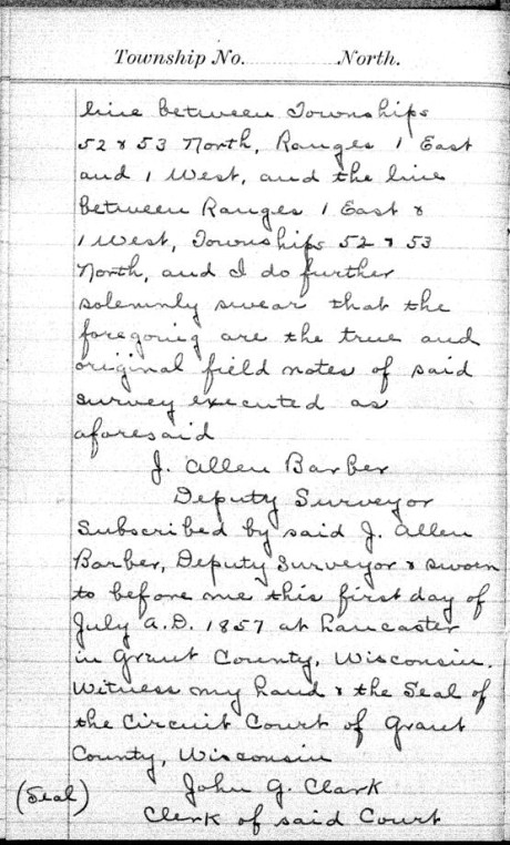
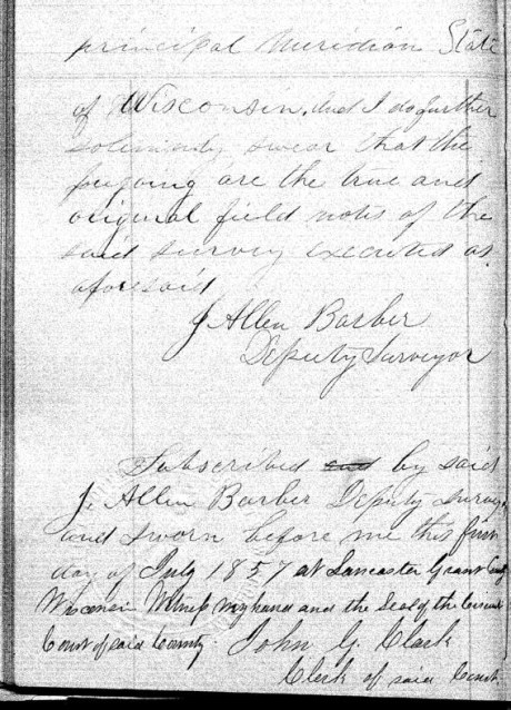
These survey notes were originally sealed in Lancaster, Grant County, on July 1st, 1857.


Interior Field Notes
Barber, J. Allen
Mar. 1857
Notebook ID: INT011E03

“No. 11 T. 46-47-52-&53. R. 1. East”
Township 46 North, Range 1 East
[Joel Allen Barber’s survey notes for this township are referenced by the the Wisconsin Public Land Survey Records, but is are omitted from the General Land Office Records. A survey map published by Charles Whittlesey in 1860 reveals diverse geology, one mineral claim, and part of the ancient Flambeau Trail were documented in this township.]

Detail of T46N-R1E and the surrounding region from Charles Whittlesey’s Geological Map of the Penokie Range, 1860.
Township 47 North, Range 1 East
[One more minor Chequamegon History editorial commentary: Joel Allen Barber’s survey notes of this township are referenced by the Wisconsin Public Land Survey Records, but are omitted from the General Land Office Records. This township is featured in the above detail of Whittlesey’s 1860 map. It is near Ironton; and contains the Mouth of the Montreal River, Superior Falls, and Saxon Falls.]

Superior Falls at the mouth of the Montreal River, as featured in the stereograph “View on Montreal River” by Whitney & Zimmerman from St. Paul, circa 1870.
~ Wikimedia Commons
Township 52 North, Range 1 East
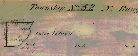
Barber’s survey of T52N R1E included the southeast corner of Outer Island, the rest of this township is occupied by Lake Superior. There are no survey notes available for this township, it was included in the survey of T53N R1E for convenience.
Township 53 North, Range 1 East

Barber’s survey of T53N R1E features the east half of Outer Island, the rest of this township is occupied by Lake Superior.
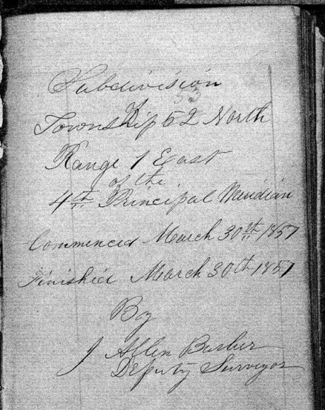
“Commenced March 30th, 1857. Finished March 30th, 1857.”

Barber’s assistants were William W. Ward, Alexander Aiken, and Louis Nevioux.

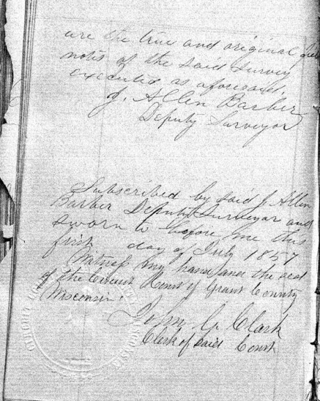
These survey notes were sealed in Lancaster, Grant County, on July 1st, 1857. Barber’s assistants were not signatories.
Interior Field Notes
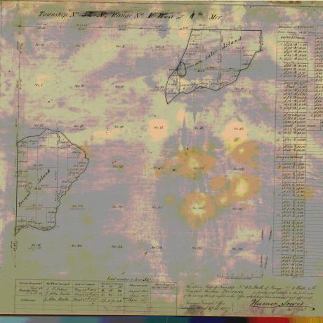
Township 51 North, Range 1 West
Barber, J. Allen
Apr. 1857
Notebook ID: INT010W04

Barber’s survey of T51N R1W included Michigan Island, Gull Island, and a corner of “Presque Island” (Stockton Island).
“Commenced April 24th, 1857, and finished on April 28th, 1857.”

Barber’s assistants were William W. Ward, Alexander Aiken, and Louis Nevioux.

These survey notes were sealed in Lancaster, Grant County, on July 1st, 1857. Barber’s assistants were not signatories.
Interior Field Notes
Township 52 North Range 1 West
Barber, J. Allen
Apr. 1857
Notebook ID: INT010W05
Barber’s survey of T52N R1W included the northeastern end of “Presque Island” (Stockton Island) and the south western end of Outer Island.

“Commenced March 28th, 1857. Finished March 31st, 1857.”

Barber’s assistants were William W Ward, Alexander Aiken, and Louis Nevioux.
These survey notes were sealed in Lancaster, Grant County, on July 1st, 1857. Barber’s assistants were not signatories.
Interior Field Notes
Township 53 North Range 1 West
Barber, J. Allen
Apr. 1857
Notebook ID: INT010W06

Barber’s survey of T53N R1W included the northwestern part of Outer Island. The rest of this township is covered by Lake Superior.

“Commenced March 29th, 1857. Finished March 30th, 1857.”

Barber’s assistants were William W Ward, Alexander Aiken, and Louis Nevioux.
These survey notes were sealed in Lancaster, Grant County, on July 1st, 1857. Barber’s assistants were not signatories.
Interior Field Notes
Township 50 North Range 2 West
Barber, J. Allen
Apr. 1857
Notebook ID: INT019W04

Barber’s survey of T51 R2W included part of Madeline Island.

“Commenced April 22nd, 1857. Finished April 23rd, 1857.”
Barber’s assistants were William W Ward, Alexander Aiken, and Louis Nevioux.
These survey notes were sealed in Lancaster, Grant County, on July 1st, 1857. Barber’s assistants were not signatories.
Interior Field Notes
Township 51 North Range 2 West
Barber, J. Allen
Apr. 1857
Notebook ID: INT019W02

Barber’s survey of T51N R2W included the LaPointe Indian Reservation Fishing Grounds on the north end of Madeline Island, and parts of “Wilson’s Island” (Hermit Island) and “Presque Island” (Stockton Island).

“Commenced April 17th, 1857, and finished April 23rd, 1857.”

Barber’s assistants were William W Ward, Alexander Aiken, and Louis Nevioux.
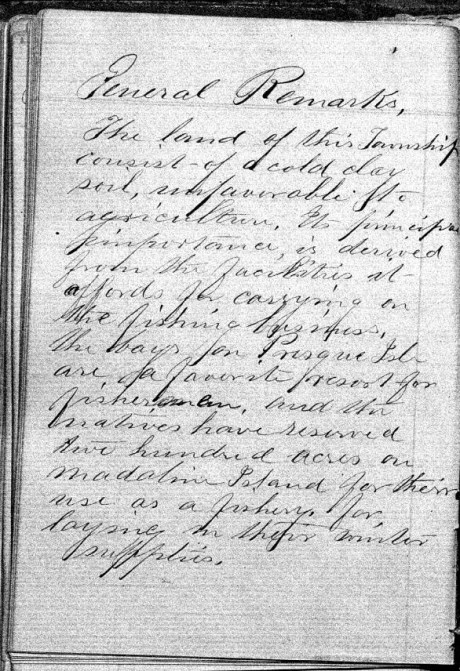
“The land of this Township consists of a cold clay soil, unfavorable to agriculture. It’s principle importance is derived from the facilities it afford for carrying on the fishing business, the bays for Presque Isle are a favorite resort for fishermen, and the natives have reserved two hundred acres on Madeline Island for their use as a fishery, for laying in their winter supplies.”


These survey notes were sealed in Bayfield on May 30th, 1857, by Samuel Stuart Vaughn as Justice of the Peace for LaPointe County. Alexander Aiken was not a signatory, yet William W Ward and Louis Nevioux (“his X mark”) were included as signatories. This nuance was not explained.

There appears to be something written or drawn behind the smaller sheet in this scan of Barber’s original survey field notes.
Interior Field Notes
Township 52 North Range 2 West
Barber, J. Allen
Apr. 1857
Notebook ID: INT019W03
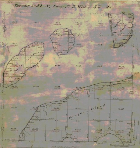
Barber’s survey of T52N R2W included “Devil’s Island” (Manitou Island), an unnamed island (Ironwood Island), and parts of “Hemlock Island” (Cat Island), and “Preque Island” (Stockton Island).
“Commenced April 1st, 1857. Finished April 25th, 1857.”

“There is but little good land in this Township, the greater part being of a very inferior quality, there is some good White Pine on Presque & Hemlock Islands.”
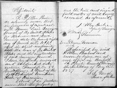
These survey notes were sealed in Bayfield on May 30th, 1857, by Samuel Stuart Vaughn as Justice of the Peace for LaPointe County. Alexander Aiken was not a signatory, yet William W Ward and Louis Nevioux (“his X mark”) were signatories. This nuance was not explained.
Interior Field Notes
Township 53 North Range 2 West
Barber, J. Allen
Apr. 1857
Notebook ID: INT019W05
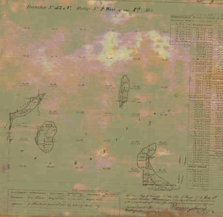
Barber’s survey of T53N R2W included “Shoal Island” (South Twin Island), an unnamed island (North Twin Island), the north end of “Hemlock Island” (Cat Island), and the east end of “Ironwood Island” (Rocky Island).

Barber’s assistants were William W Ward, Alexander Aiken, and Louis Nevioux.
These survey notes were sealed in Lancaster, Grant County on July 1st, 1857. Barber’s assistants were not signatories.
Interior Field Notes
Township 51 North Range 3 West
Barber, J. Allen
Apr. 1857
Notebook ID: INT030W06

Barber’s survey of T51N R3W included parts of “Bass Island” (Basswood Island), “Wilson’s Island” (Hermit Island), Oak Island, and the mainland where the Red Cliff Band of Lake Superior Chippewa was located six years later in 1863.

“Commenced April 14th, 1857. Finished April 28th, 1857.”

Barber’s assistants were William W Ward and Alexander Aiken, and Louis Nevieux.

“The land in this Township is all high and rolling and is pretty well adapted to agricultural pursuits, the soil is gravelly and in some places stony. The poorest portions are Wilson’s and Bass Islands, which contain more clay. Much good White Pine & Hemlock are found on the Main shore near the Lake.”

These survey notes were sealed by Samuel Stuart Vaughn at Bayfield on May 30th, 1857, by Samuel Stuart Vaughn as Justice of the Peace for LaPointe County. Alexander Aiken was not signatories.
Interior Field Notes
Township 52 North Range 3 West
Barber, J. Allen
Apr. 1857
Notebook ID: INT030W07
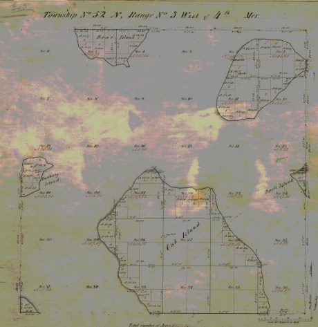
Barber’s survey of T52N R3W included parts of Oak Island, “Devil’s Island” (Manitou Island), Bear Island, “Cranberry Island” (Raspberry Island), an unnamed island (Otter Island), and the mainland where the Red Cliff Band of Lake Superior Chippewa were located six years later in 1863.

“Commenced April 4th, 1857. Finished April 29th, 1857.”
Barber’s assistants were William W Ward, and Louis Nevioux. Alexander Aiken is not identified as an assistant in this survey.

“The principal part of the land of this Township is of good quality. Oak & Bear Islands are very high and rolling with a good soil. The Island in the N.E. part of the Township is more level, but it soil is of a good quality.”

These survey notes were sealed by Samuel Stuart Vaughn in Bayfield on May 30th, 1857, as Justice of Peace for LaPointe County.
Interior Field Notes
Township 53 North Range 3 West
Barber, J. Allen
Apr. 1857
Notebook ID: INT030W08

Barber’s survey of T53N R3W included an unnamed island (Devils Island), the west end of “Ironwood Island” (Rocky Island), and the north end of Bear Island.

“Commenced Apr 4th, 1857. Finished Apr. 7th, 1857.”
Barber’s assistants were William W Ward, Alexander Aiken, and Louis Nevioux.
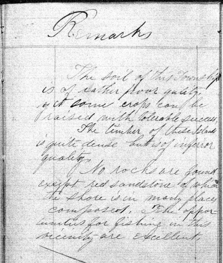
“The soil of this Township is of rather poor quality, yet some crops can be raised with tolerable success. The timber of these Islands is quite dense but is of inferior quality. No rocks are found except red sandstone of which the shore is in many places composed. The opportunities for fishing in this vicinity are excellent.”

These survey notes were sealed in Lancaster, Grant County on July 1st, 1857. Barber’s assistants were not signatories.
Interior Field Notes
Township 51 North Range 4 West
Barber, J. Allen
Apr. 1857
Notebook ID: INT040W04

Barber’s survey of T51N R4W on the mainland was used to locate the Red Cliff Reservation years later in 1863

“Commenced April 30th, 1857. Finished May 8th, 1857.”

Barber’s assistants were William W Ward, Alexander Aiken, and Loius Nevioux.
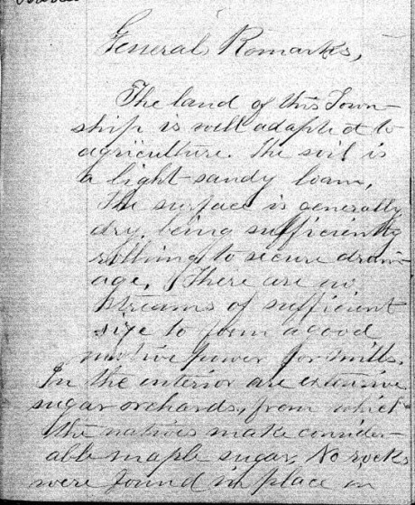
“The land of this Township is well adapted to agriculture. The soil is a light-sandy loam. The surface is generally dry, being sufficiently rolling to secure drainage. There are no streams of sufficient size to power a good motive power for mills. In the interior are extensive sugar orchards, from which the natives make considerable maple sugar. No wells were found in place in …”

“… this Township, but it belongs to the sand-stone formation and is overlaid by drift,- in some places to the depth of several hundred feet. No houses or other improvements were noticed.”


These survey notes were sealed in Bayfield on May 30th, 1857, by Samuel Stuart Vaughn as Justice of Peace for LaPointe County. Alexander Aiken was not a signatory, yet William W Ward and Louis Nevioux (“his X mark”) were signatories. This nuance was not explained.
Interior Field Notes
Township 52 North Range 4 West
Barber, J. Allen
Apr. 1857
Notebook ID: INT040W05

Barber’s survey of T52N R4W included Point Detour on the mainland, an unnamed island (York Island), the west end of “Cranberry Island” (Raspberry Island), and the east end of “Sand River Island” (Sand Island).

“Commenced April 8th, 1857. Finished April 12th, 1857.”
Barber’s assistants were William W Ward, Alexander Aiken, and Louis Nevioux.
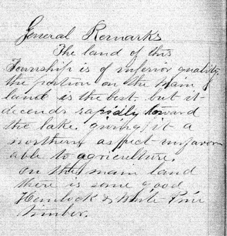
“The land of this Township is of inferior quality, the portion on the main land is the best, but it descends rapidly toward the lake, giving it a northern aspect – unfavorable to agriculture. On the main land there is some good Hemlock & White Pine timber.”


This survey contract was at Bayfield on May 30th, 1857, by Samuel Stuart Vaughn as Justice of Peace for LaPointe County. Alexander Aiken was not a signatory, yet William W Ward and Louis Nevioux (“his X mark”) were signatories. This nuance was not explained.
Interior Field Notes
Township 52 North Range 5 West
Barber, J. Allen
Apr. 1857
Notebook ID: INT050W04

Barber’s survey of T52N R5W included “Steamboat Island” (Eagle Island), “Little Steamboat Island” (no longer exists), and most of Sand Island.
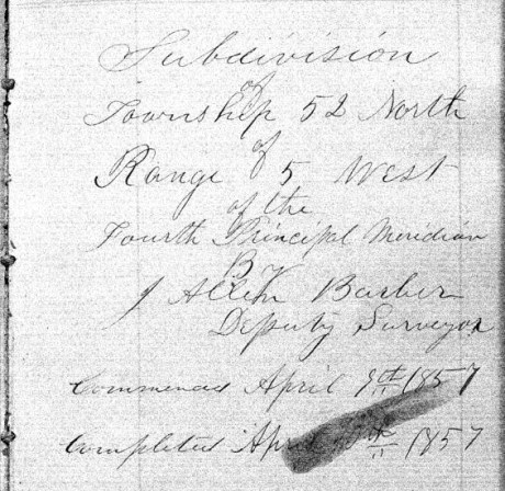
“Commenced April 8th, 1857. Finished April 10th, 1857.”

Barber’s assistants were William W Ward, Alexander Aiken, and Louis Nevioux.
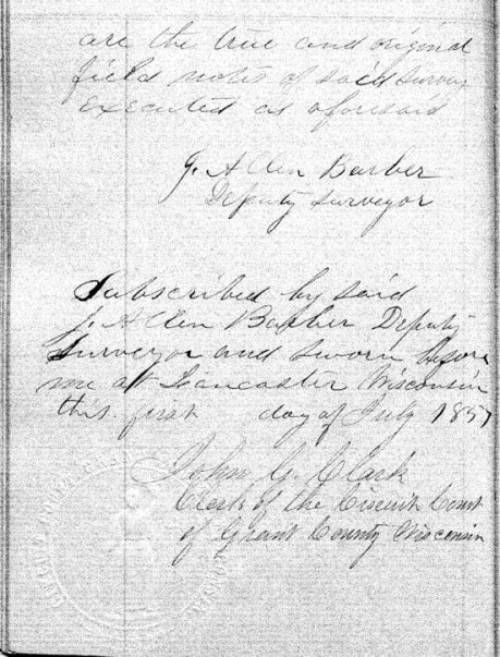
These survey notes were sealed in Lancaster, Grant County on July 1st, 1857. Barber’s assistants were not signatories.
Bayfield Mercury, August 22, 1857.
IRONTON
The Barbers did business with William Herbert and others at Ironton. The activities of “the company“ during the Summer of 1857 are detailed the Penokee Survey Incidents.
“… Wm. Herbutt, was here in 1847-48 prospecting for copper for the American Fur Company.”
Report of the City Statistician, Volume 1, page 58.
Week before last we took a trip to Ironton and the interior in company with Mr. HERBERT, the Agent of the town, and several others, and promised to give our readers an account of the the town and country back of it, but inasmuch as some kind friend took the liberty of abstracting our memorandum book from our pocket, we cannot give as definite an account as we would like.

Lake Superior surveyor, American geologist, and Harvard University professor Josiah Dwight Whitney. ~ Portrait of Whitney by Silas Selleck, 1863.
Ironton is situated on the South shore about 20 miles from this place and three fourths of a mile from the mouth of the Montreal river, which is the State line between this State and Michigan. Its harbor is good and the water is of sufficient depth for any of the largest class of steamers. The company are building a splended pier, 400 feet long, and when finished it probably will be one of the most substantial piers on the Lake, and will cost about $5000. They have also erected a large Hotel, two stories high, and we also noticed the materials on the ground for putting up several frame buildings, and arrangemnts has been made for the erection of a steam sawmill with 40 horse power, which is to be completed this summer, and will cost from $10,000 to $12,000. The lots are 40 x 125, except on 1st and 2nd streets which are 40 x 128.
The site of the town is beautiful, — about a third of it is on a nice level next to the Lake, and then it ascends gradually in benches back for one or two miles. Its near proximity to the Copper mines on the Montreal river and the Iron range back, together with the farming lands, which by the bye is not equalled on Lake Superior, must needs make Ironton a town of no small importance. The company are cutting out a good road from Ironton to the Iron range some 16 miles in length.
While there we visited the Falls on the Montreal river, the scenery of which cannot be surpassed on the Lakes. The lower falls are 60 feet high and the upper falls are 80 feet. They are about three miles apart. The indication of mineral between the two falls and especially on Mr. WHITNEY’s claim, bids as fair for large deposits of copper as any that has yet been discovered and certainly has a good surface show as had any of the mines that are now being developed.
We could say much more about the Iron range and surrounding country, but defer it until another time. The town was only laid out in February last, and it already bids fair for a bright future. Go on gentlemen, we hope you will build up a large town, and help develop the vast resources of the Great Northwest, and we will aid you what we can.
Lancaster Aug 30th 1857
Dear Son.
Maria Green Barber. She came to Lancaster to visit her in-laws, and to consider relocating there from Vermont.
A week or more since I rec’d a letter from [you?] at Bayfield by [????] I am happy a safe arrival for which I am very thankful. But in it you don’t say where your father is. [??? ???ably] return or whether he intends to come here, or go home, or other ways expecting me to go along [???? ?? ?? ????? ????] I have not had a letter from him since you left but father Barber goes on some other which road. I have not [?????] to [????????] as [????????????] about [?? ???] there to get it. Mr Burr [??????] last [??? ???] – I did not know what to do about going but as the friends here so I Pray [??? ???] he would come this way to see to his produce [????????] was out state with [???] that time I thought but to wait a little longer. [?? ??? ????] an [????] I wished I would stay with this while [?? ??? ???] as they are rather homesick [???] the [???? ??? ??? ??? ????? ??????] [????? ??? ??????] I enjoy myself better with them than of [???? other affect?] as it is such a pleasant family and very young so comfortable quilt – Last evening the Bank came up here to give me a seranade. They had intended to come [???] and were expected and They were invited in and treated to Coffee, pie, and cake and the girls gave them the best music – as they said – on the Piano they ever heard – Then they all joined in several songs They went to nearly every house in the town “to wake them up.” Yesterday Miss Barber got in another exhibition – that is, had them (her exhibit) & had something to speak – had a stage in [??????] grove where they exhibited had a pre-mer. I tried to get some – singing – pretty much failed in that – tried to get out there hard and wholely failed – and on the whole, not “[????? ???????]” they say.
It is quite [??????] here [????????? ???? ????] several others of summer complained. There has been hot months but, [???? ?????? ???? ????? ????? ?????] Esq [M????] wife are considered [????? ??? ????]
I wish I knew what [???? ? ??? ???? ????] as your father would write [??????? ??????? ????? ??? ???] to go home without [???????] at last. Got a line from [Albe?] last week. Suppose he [????] to as he does not [?????] to [???????????????????] but “lying ‘round longer.” [??? ??] very sorry he was not that [winter?] the government and instruction of some one who would have taught him something useful and kept in a study.
It is beautiful weather now for gathering the grain [????? ???? ????? ????????? ????] will be plenty of them but very little fruit of any kind this year.
I expect father will come this week without fail if he comes at all. Have heard nothing more about going to Cassville. Uncle Allen is building a large office and Cyrus and Thode are building the Evert house fence. Write often, till you come, to your
Mother
Johnson Sept 20 /57
Friend Allen
May I call you friend? I will venture for if I recollect right we were once very good friends and I hope that we are so still although we are far distant from each other, and may never meet again in this world, have you forgotten Hattie? I have not forgotten Allen and probably never shall, and were I even disposed I have a small gillon badge laid safely away which brings forcably to my mind an old friend who much resembles you, when I once knew. Amherst said he presumed you would not think I was very naughty to dare to write to you, so I thought I would take the liberty. I have written enough so I will close by saying please don’t forget the Johnson people for we shall never forget you.
Good night
Hattie C.
P.S.
Beware of those pretty squaws out there.
Allen,
I want you to understand that Miss Hattie & Miss Hastings & Carls & I have spent the evening here together at Mr. Caldwells upstairs & have had all sorts of good times. That is, as far as I am concerned. (I do not speak for the ladies) & I have enjoyed myself “excruciatingly” (as Hattie suggests) considering the company & the advantages I had.
That’s all
Am
Lancaster Sept 20th 1857
Dear Son.

Portrait of George Riley Stuntz. ~ The Eye of the North-west: First Annual Report of the Statistican of Superior, Wisconsin by Frank Abial Flower, 1890, page 26.
I will venture to write once more to you tho I have no evidence that my letters ever reach you. I have had two letters from you but not one from father since you left here. One from him to Mr Burr of Sept 15-6th appears to be the only one he has sent here since you arrival. Why he has not written to me to let me know what to do about going home I cannot understand, but here I am yet, and shall stay, until he either comes or writes he is not coming. I should have written several times to him, had I not expected him every week [??????????] letter [????] that you had not [??????] from [???????] I had not gone home with Mr B. Mr Stunts [visited?] here, and said he was going [??????] to La Pointe [???? ??????] you have learned the state of affairs before this. Mr [??] returned home last night having been about now a few weeks, had a fortunate trip tho on Lake Ontario there was a high wind and every passenger very sick. I am thankful to have escaped that, but something else may happen to us when I do go. Oh how I do dread the journeys.
I am confident that your father will be here this week, that is if he is not still too sick to come – which I greatly fear he is. If he is still there when this arrives he may [c??????] it as much to him as to you. How I wish you would confide to travel there this fall and to remain with [me?] [?????] to me the [??????????] and remain there this winter [?????????????????????????????????????????????????????]
There will be a County Fair held here this week – the grounds in full view of Uncle Jay’s where I am now stopping. I shall probably see some of the best food [ration?] of this great country. I went, two weeks since to McCartney and Cassville with Allen and family. Had a pleasant ride, but it was very warm and dusty. Mc has a beautiful place, the largest orchard in the county, I suppose, as they will have 500 bushels this fall. It is on the highest land 2 miles east of the Miss. river. But perhaps you have been there, if not you have seen the river at other points. I was wishing to see the “great river” and went to Cassville for that purpose. It is certainly worth the trouble of going to see. Aunt Sa’h pointed out to me a high sharp bluff which Augustus climbed and left his name out on the white bark of a [tree?]. To me, how interesting – almost sacred does every thing appear where he has left the impress of his work. There is nothing can bring so forcibly to our minds a dear departed friend, as a sight of the productions of his hands or his mind. So, if we would be remembered with pleasure and gratitude we must do something for the good of every being with whom we have to do.
“IN MEMORY OF
AUGUSTUS H. BARBER
of Cambridge, Vt. U.S. Deputy Surveyor
who was drowned in
Montreal River
Apr. 22. A.D. 1856
Aged 24 yrs. & 8 ms.”
~ FindAGrave.com
I hope your father has placed the marble he sent me enclosed the grave of the dear one who lies on the land here, I feared shall never have the melancholy satisfaction of visiting the cursed spot. It hardly know whether I can wish to behold the terrible scene where he lost his prime life. I cannot but fear that those of my family now in that inhospitable shore may be laid beside that line [??] bed grave that we may all live to [???? ???? ?????].
And land flowing with milk and sugar – than which no better can be found, at least I have yet found a place better adapted in all respects to make life comfortable. With labor and care we can have all that is desirable there – without those we can h should have little enjoyment here unless we are content to live in poverty and filth. One thing alone would discourage me from coming to this Western world, where in the great uncertainty or procuring a constant convenient supply of good soft water. Here, at Jay’s, their Cistern leaks and they have to fix up the pump and have to draw it from the bottom where it [????? ?? ???] with a pail and string, as they do at Allen’s and Thode’s you know there is no cistern and they manage to catch some in tubs to wash with.
It would almost kill Marth and the girls to bring enough from the spring near as it is, based on when they get it, it is good for nothing to wash with in that it is cleansed with [??? ?? ???]. I never yet saw water so convenient, plenty and good as it is at our old home.
Mr. Harris [?????] died about 3 weeks since, and Mrs. Mills is not expected to live but a few days – perhaps hours. It has been very healthy most of the [senses?] People from other places come here to spent the summer on account of the known healthfulness of the place. One gentleman from Cleveland, with consumption, and the Drs said, come – at the end of the 1 week, he had gained 12 lbs – Says he will buy property and stay here. [Sherman Page?] is here – has commenced a select school.
I have no more to [??????????????????????????]
your Mother
Aunt Lucy is unwell to day and I have [????] the [?????].
All friends well but Allen who has his old complaint.
Am sorry this ink is not black & you can read it.
