1854 Treaty Lands at Apostle Islands National Lakeshore
March 20, 2026
Collected & edited by Amorin Mello
 The Chequamegon area’s Apostle Islands National Lakeshore has been in the news lately due to the reintroduction of Congressman Tom Tiffany’s proposed Apostle Islands National Park and [Sand Island] Preserve Act. This proposed Act has been controversial due to strong opposition from local governments citing lack of consultation and insufficient infrastructure, among other concerns.
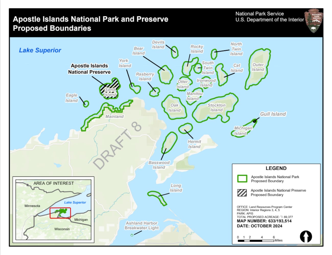
The goal of this post is to raise awareness about how the current Apostle Islands National Lakeshore contains roughly 3,000 acres of tribal lands reserved by the 1854 Treaty of La Pointe, and should consider returning these tribal lands back to the Lake Superior Chippewa before making any changes to become the proposed Apostle Islands National Park and Sand Island Preserve.
The current Apostle Islands National Lakeshore contains 3 types of lands reserved by the 1854 Chippewa Treaty of La Pointe:
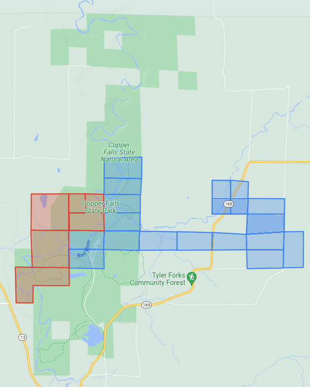
29 Allotments (red) within the Red Cliff Reservation,
14 Allotments (blue) on Stockton, Hermit, & Basswood Islands,
and the disputed Bad River Reservation (purple) on Long Island.
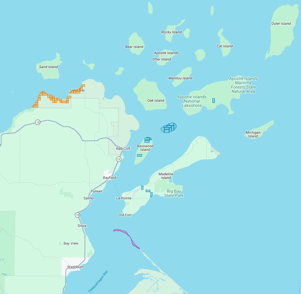
All of the Apostle Islands are part of the ceded territory from the 1842 Treaty of La Pointe covering roughly 22,000 square miles in northern Wisconsin and Michigan. The historical context of this 1842 ceded territory was to allow Americans to move into copper-rich areas while still retaining hunting, fishing and gathering rights for the Lake Superior Chippewa on those same lands. In modern context, this 1842 ceded territory has natural resource managed jointly between the States of Michigan and Wisconsin, the Lake Superior Chippewa, and Great Lakes Indian Fish & Wildlife Commission (GLIFWC).
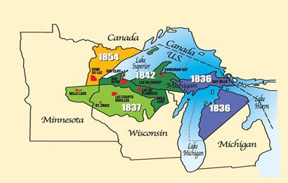
Map of 1836, 1837, 1842, and 1854 ceded territories jointly managed by the Great Lakes Indian Fish & Wildlife Commission (GLIFWC).
The 1854 Treaty of La Pointe reclaimed certain lands within the 1842 ceded territory to be reserved as permanent homelands for the Lake Superior Chippewa Bands in the form of Reservations and Allotments. For more information, we have covered the debates and circumstances leading up to the creation of these Reservations and Allotments in great detail on this blog, such as the Sandy Lake Tragedy and Ojibwe Removal events. Unfortunately much of those Reservations and Allotments have become “checkerboarded” or alienated from the Lake Superior Chippewa despite the original intention of being permanent homelands.
In this post we will examine roughly 3,000 acres of those Reservations and Allotments from the 1854 Treaty of La Pointe that are contained within the Apostle Islands National Lakeshore today. For clarification, there is a Reservation and several Allotments on Madeline Island, which are outside of the Apostle Islands National Lakeshore and will be discussed at a later date instead of in this post. Nor are we including any of the 1887 Dawes Act Allotments on the Apostle Islands in this post, because they are not from the 1854 Treaty.
Without further ado…
Zaagawaamikong-neyaashi
(roughly translated as “long soft beaver dam point”)
a.k.a. Chequamegon Point and Long Island
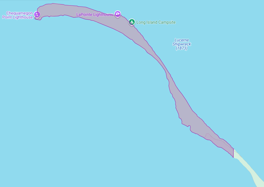
The Apostle Islands National Lakeshore contains Chequamegon Point (roughly 300 acres) on Long Island located at the Bad River Reservation (a.k.a. Mashkiiziibii).
Currently, federal maps of Long Island depict Chequamegon Point to lie outside the Bad River Reservation boundaries. Ownership of Chequamegon Point has been disputed between Bad River and the Federal Government for many generations since the 1854 Treaty.
This dispute is based on how the Second Clause of the Second Article of the 1854 Treaty of La Pointe defined the boundaries of the Bad River Reservation to follow “along the lake shore, crossing Shag-waw-me-quon [Chequamegon] Point, to the place of beginning“. In recent years, Bad River has been conducting a Historical Background Study about the 1854 Treaty of La Pointe and the Chippewa understanding of how they negotiated with Federal negotiators to include Chequamegon Point in Bad River’s lakeshore reservation boundaries.
We have mentioned this ongoing dispute in past posts, and will continue to examine historic records in support of Bad River’s efforts to repatriate tribal ownership of Chequamegon Point.
Gaa-giishkidaawangaa-wiikwedong
(roughly translated as “sand bay”)
a.k.a. Sand Point, Sand Bay, and Little Sand Bay
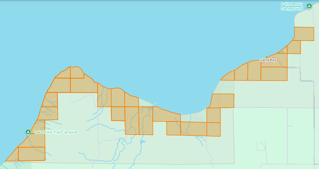
The Apostle Islands National Lakeshore’s Mainland Unit contains 29 Allotments (roughly 1,550 acres) located at the Red Cliff Reservation (a.k.a. Gaa-miskwaabikaang). The Sand Bay shoreline contains three Allotments (uncolored) that are owned by Red Cliff.
The media often cites the 1887 Dawes Act when describing how Allotments on the Lake Superior Chippewa Reservations became alienated from tribal ownership. That is factually incorrect, because these Allotments came from the 1854 Treaty of La Pointe, which precedes the 1887 Dawes Act by several decades. The key difference here is how these 1854 Chippewa Treaty Allotments were designed to reserve tribal land that would never be taken away later, while the later 1887 Dawes Act Allotments were designed to be alienated/sold after a period of 25 years. Unfortunately the 1854 Treaty Allotments were mismanaged by non-tribal governments as being temporary instead of permanent.
This mismanagement has caused much damage over time in the form of “checkerboarded” tribal land bases, which explains the legacy of how these 29 Allotments inside the Red Cliff Reservation fell out of tribal ownership and became part of the original boundaries of the Apostle Islands National Lakeshore.
In 1970, two additional Allotments along the Sand Bay shoreline were targeted to become part of the original boundaries of Apostle Islands National Lakeshore, but ultimately never became alienated from tribal ownership. Today these two Allotments still remain excluded from the boundaries of the current Apostle Islands National Lakeshore and proposed National Park.
In 2018, a third Allotment along Sand Bay that had fallen out of tribal ownership due to “checkerboarding” was repatriated from Town of Russell ownership back to tribal ownership, and is now a Tribal Management Unit of the Apostle Islands National Lakeshore.
The proposed boundaries of the Apostle Islands National Park and [Sand Island] Preserve Act contain this repatriated Allotment, but not the two Allotments that were never alienated from tribal ownership.
Wiisaakodewan-minis
(roughly translated as “half-burnt wood island”)
a.k.a. Stockton Island or Presque Isle
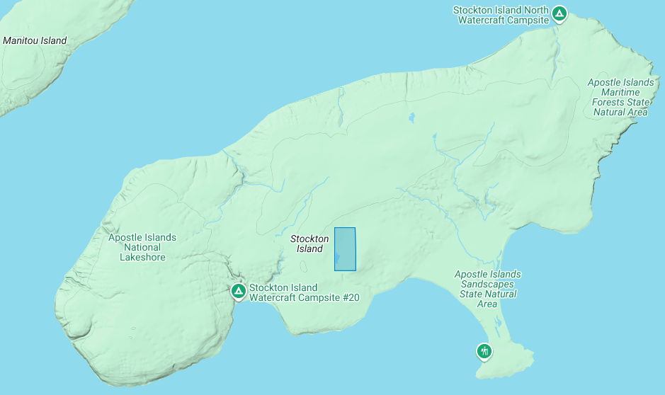
The Apostle Islands National Lakeshore contains one allotment (roughly 80 acres) on Stockton Island:
1) Joseph Gauthier (a.k.a. Gokee) Senior
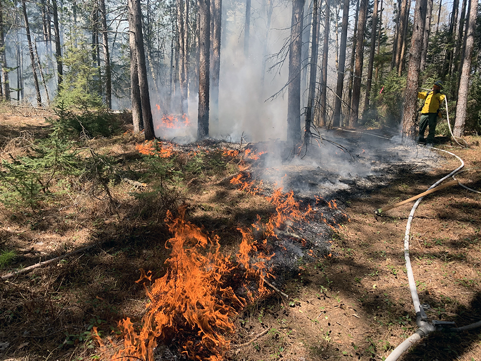
A prescribed fire on Stockton Island conducted by National Park Service and Tribal partners.
~ Photo by Dave Cooper at NPS
The root word of island’s traditional name, Wiisaakodewan (half-burnt wood), refers to Stockton Island’s historic appearance of being partially burnt. In recent years, the Apostle Islands National Lakeshore and the Lake Superior Chippewa have jointly reintroduced the practice of using prescribed fire management to promote the growth of blueberries and other traditional ecological resources on the cultural landscape of Stockton Island.
Wiisaakodewan also happens to be the root word of a pejorative slang term describing the Mixed Blood people of Lake Superior Chippewa. At the time of the Treaty Era, the Mixed Bloods of the Lake Superior Chippewa held a strong connection to this island via the tribal fishing industry. For example, the surveyor Joel Allen Barber described how “the bays on Presque Isle [Stockton Island] are a favorite resort of fishermen” in connection to the tribal fishing grounds of the La Pointe Indian Reservation on Madeline Island’s north end.
Wiigobiish-minis
(roughly translated as “basswood island”)
a.k.a. Basswood Island
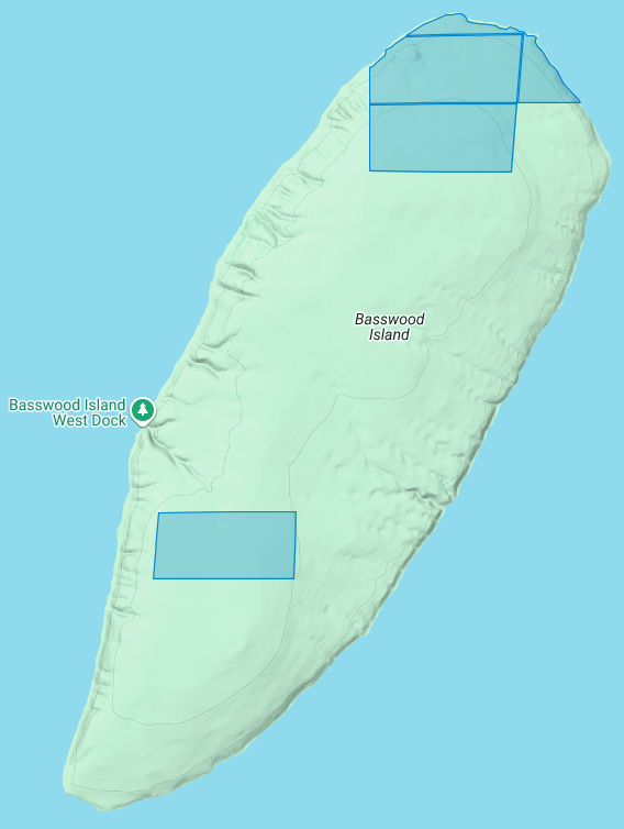
The Apostle Islands National Lakeshore contains four allotments (roughly 290 acres) on Basswood Island:
1) John Baptist Berriot
2) Henry Bresette (a.k.a. Brisette)
3) John Baptist Lemieux
4) Louis Neveaux
In a previous post we briefly mentioned that the infamous John Breckenridge made national news with his land speculation on Basswood Island immediately following the 1854 Treaty of La Pointe. In a few short years Breckinridge would become Vice President of the United States, and also a Confederate States Army brigadier general during the Civil War.
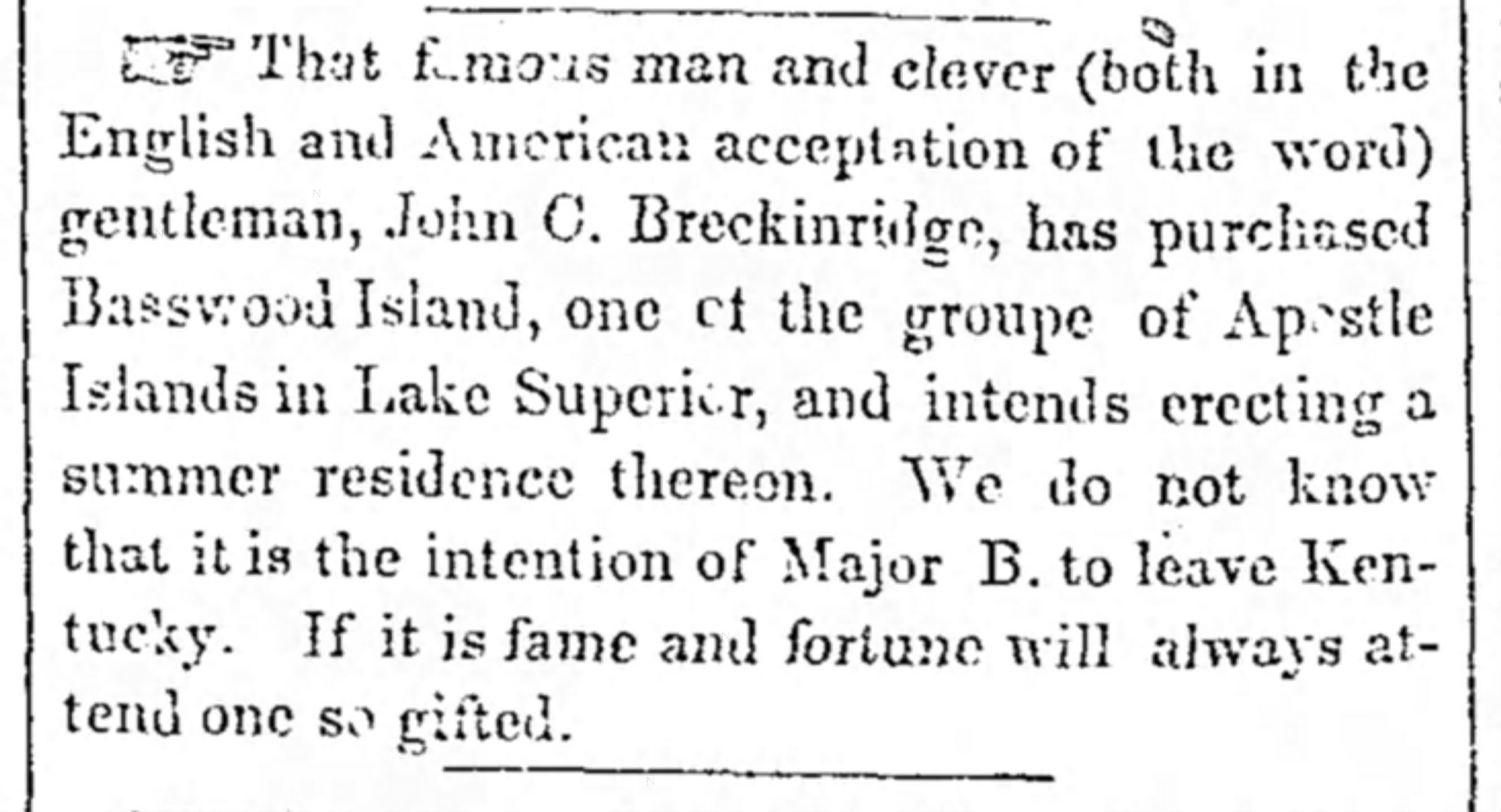
The Louisville Daily Courier [Kentucky], August 14th 1855, Page 4.
Eshkwegwindeg-minis
(roughly translated as “floating at the end or behind island”)
a.k.a. Hermit Island
f.k.a. Austrian Island
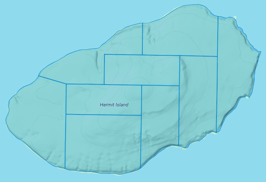
The Apostle Islands National Lakeshore contains nine allotments (roughly 780 acres) covering all of Hermit Island:
1) Josette Deefoe (a.k.a. Defoe)
2) Michael Defoe
3) Francois Dejadin (a.k.a. Artishon) Junior
4) Charles Dingley
5) Mary Dingley
6) Mary DuBay
7) Louis Gaudin (a.k.a. Gordon)
8) John Baptist Goslin (a.k.a. Gauslin)
9) Elizabeth (a.k.a. Isabella) Tremble
The traditional name of Eshkwegwindeg appears to be referencing this island’s location between the mainland and several other Apostle Islands. Today it still remains a central hub between the Red Cliff Reservation, the La Pointe Reservation on the north end of Madeline Island, and the other Apostle Islands with Allotments. It is noteworthy how the entirety of this Island is covered by Allotments, unlike the other aforementioned Islands.
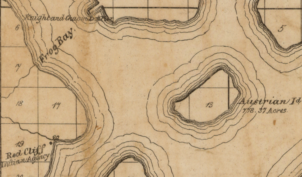
Austrian Island on Asaph Whittlesey’s 1871 map of Apostle Islands and Harbor of Bayfield and Its Surroundings.
~ Wisconsin Historical Society
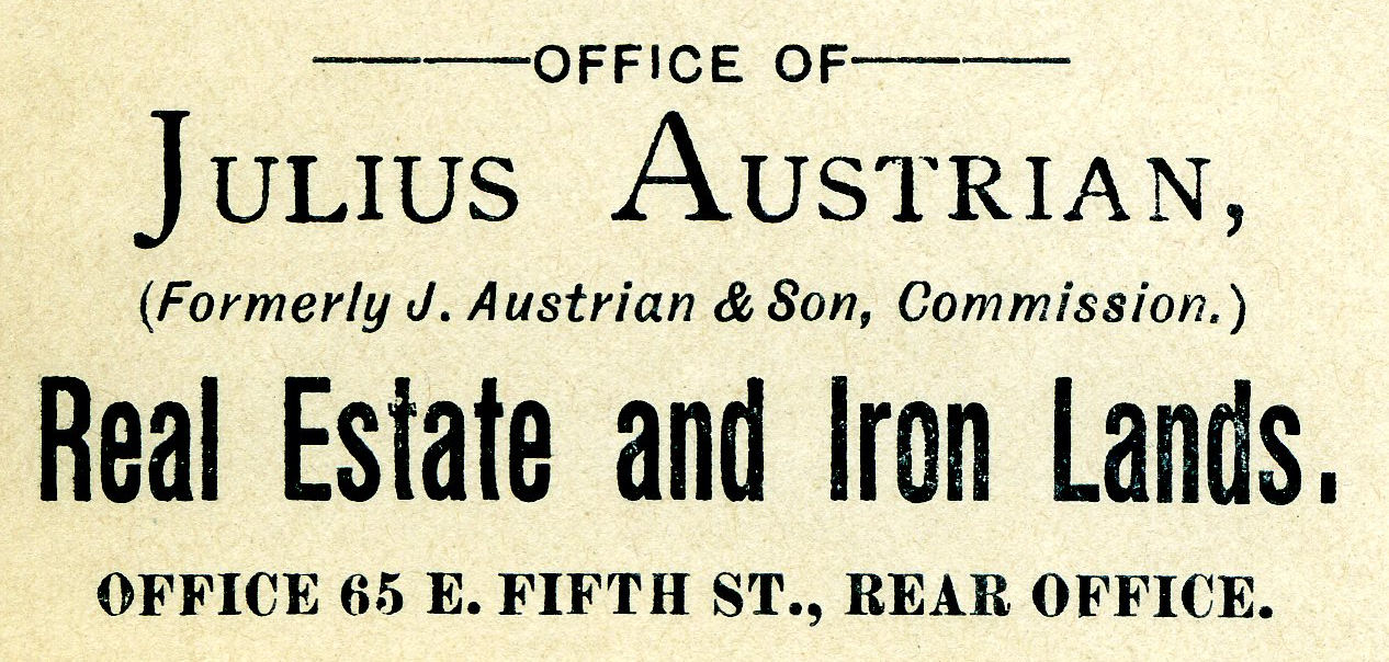
Modern maps call this Hermit Island in reference to the colorful story of how William Wilson was ostracized from La Pointe and relocated to this Island to live out a solitary life during the Treaty Era. The famous “brownstone king” Frederick Prentice‘s connection to this Island in later decades is also a popular story being told by tour guides in modern times. However, I personally am more interested in exploring the history of how this Island was know as “Austrian Island” between the Wilson and Prentice eras, because it illustrates Julius Austrian’s abuse of Allotments to take private ownership of what should be tribal lands for personal profit.
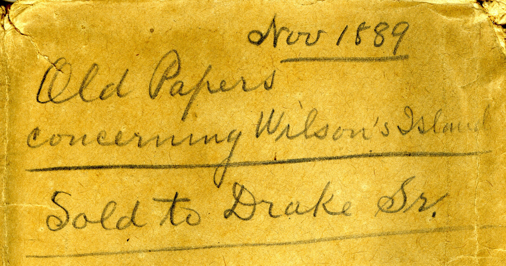
Madeline Island Museum
JULIUS AUSTRIAN PAPERS (2011.158.A) Folder 5:
PAPERS RELATING TO WILSON’S ISLAND (HERMIT ISLAND IN THE APOSTLE ISLANDS ARCHIPELAGO), WISCONSIN (1870-1888)
Julius Austrian’s corporate letterhead circa 1888 advertising Allotments for sale.
I personally became very interested in Chequamegon history specifically because of Julius Austrian and his abuse of Allotments to take private ownership of what should be tribal lands in the Penokee Mountains for personal profit, and how that legacy evolved to become what is still known as the La Pointe Iron Company today.
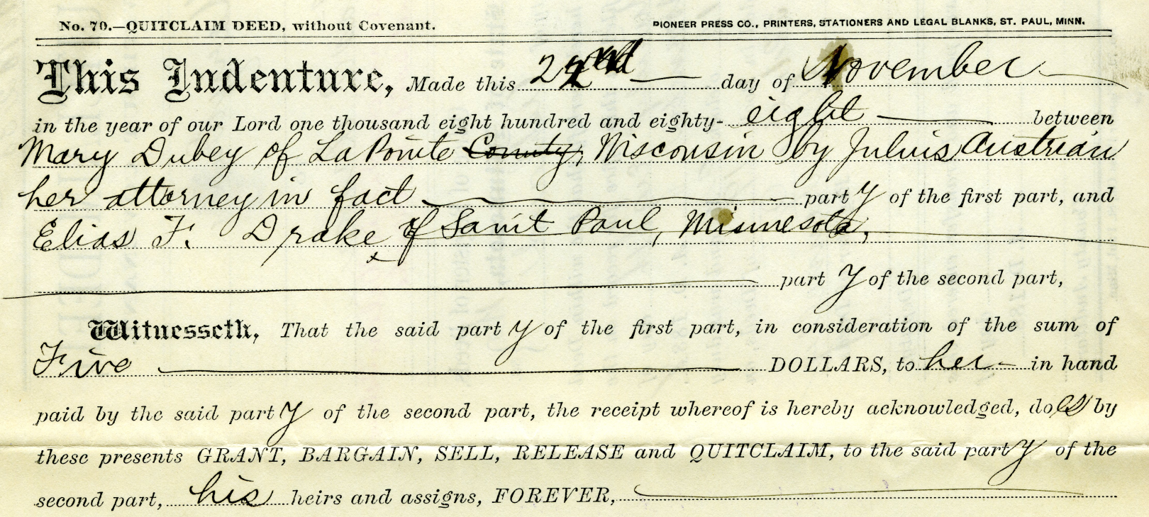
Example of Julius Austrian using Power Of Attorney to buy Mary DuBay’s Allotment for $5 so he could later flip it for profit as private property.
Austrian’s land speculation on Hermit Island follows the same trend of using Allotments via power of attorney over Mixed Blood tribal members of the Lake Superior Chippewa to grab ownership of prime real estate before other land speculators. In the Penokees example, Austrian gave each Mixed Blood $100 to sell their Allotments via Power of Attorney, but here we see how Austrian gave Mary DuBay only $5 for her Allotment on Hermit Island.
My research has been the foundation of academic research in Larry Nesper’s book Our Relations…the Mixed Bloods, and I will continue to post more on this topic in the Austrian Papers on this website.
So what?
Regular readers of Chequamegon History know that my writing style is to post historic documents enhanced with multimedia and sidebars, but omit my own interpretations and and just let readers reach their own conclusions. Leo, on the other hand, is more inclined to speak out about the implications, such as in his posts 19th Century Deer in the Headlights and Slavery, Debt Default, and the Sandy Lake Tragedy. However, in this case, due to Congressman Tom Tiffany’s ongoing efforts despite strong opposition from local governments, I felt it was important to expound on this issue a bit more than I usually do.
Righting a Wrong: Restoring Lands to the Leech Lake Band of Ojibwe
In 2020, the Leech Lake Band of Ojibwe Reservation Restoration Act (Public Law 116-255) returned approximately 11,760 acres of allotted lands wrongfully taken by the Chippewa National Forest back to Tribal ownership and management. The same concept should be applied to repatriate tribal lands in the Apostle Islands National Lakeshore before moving forward with the proposed Apostle Islands National Park and Preserve Act.
Lac Court Oreilles Band of Lake Superior Chippewa v. Walker, Evers
Tribes of the 1854 Chippewa Treaty in Michigan and Wisconsin have won two important lawsuits in recent years due to the fact that their tribal lands should have been reserved under the 1854 Treaty of La Pointe instead of becoming “checkerboarded” from illegal taxation/foreclosures.
Red Cliff Band of Lake Superior Chippewa Indians v. Bayfield County
What started off as a dispute about zoning authority over tribal lands has developed into a constructive partnership. Bayfield County and Red Cliff have developed a Memorandum of Understanding that has led to repatriation of tribal lands within the Red Cliff Reservation. This has led to 2,500 acres being returned by the County to Red Cliff in recent years, with the last 900 acres being completed in 2022.
While returning all County-owned surface rights within the Reservation back to the Tribe has been a tremendous achievement, the County still owns mineral rights within the Red Cliff Reservation. Mineral rights supersede land rights under Wisconsin law, so more work still remains to be done in these land repatriation efforts between Bayfield County and Red Cliff.
Bayfield County should promote their efforts in recent years to help Red Cliff repatriate 2,500 acres of County-owned lands back to tribal ownership, and encourage the Apostle Islands National Lakeshore to return their 3,000 acres of Reservation/Allotments back to tribal ownership.
Frog Bay Tribal National Park
Congressman Tom Tiffany claims that his proposed Apostle Islands National Park and Preserve Act would create the first National Park in Wisconsin. However, Red Cliff already earned that claim to fame in 2012 by establishing the Frog Bay Tribal National Park through an innovative partnership to repatriate Allotments on their Reservation from non-native landowners.
We would much rather see the establishment of a Sand Bay Tribal National Park in Red Cliff, a Chequamegon Point Tribal National Park in Bad River, and Tribal National Parks for the Apostle Islands Allotments, before the proposed Apostle Islands National Park and Preserve. Ultimately these Tribal Lands should be returned to the Lake Superior Chippewa and let them decide whether to manage them as Tribal National Parks or not.
Treaty Allotments at Copper Falls
February 17, 2022
Collected & edited by Amorin Mello

Chippewa Treaty (blue) and Sioux Script (red) treaty land allotments in the Penokee Mountains located along mineral deposits near Mellen, Wisconsin.
[LaPointe County Register of Deeds: Volume 2 Deeds Page 419]

Julius Austrian had better success entering lands with Chippewa Certificates along the iron range for the Leopold & Austrian family’s La Pointe Iron Company than here along the copper range.
Be it known to all men that I Julius Austrian of Lapointe County State of Wisconsin am held and firmly Bound unto Julius [Bernault?], Peter King, Abraham Comartin, John W Bell & Henry Merryweather and to Each of them Separately in the Sum of One thousand Dollars for which payment will and truly to be made I bind my self my heirs executors and administrators firmly by these presents.
The condition of the above obligations are such that whereas the above mentioned Julius [Bernault?], Peter King, Abraham Comartin, John W Bell & Henry Merryweather having Squatted and improved the following mentioned Lands in Lapointe County with the intent of Claiming the Same as a Town Site namely the East half of Section No Seventeen (17) of Township number Forty five (45) of Range no two (2) and have agreed with the said Julius Austrian that he may enter the above described lands by Chippewa Script or otherwise at his option.

The “East half of Section No Seventeen (17) …” is where the Bad River and Tyler Forks River join spectacularly at what is now Brownstone Falls in Copper Falls State Park.
Now if the said Julius Austrian shall with due diligence enter the same as provided and obtain a Patent or Patents as Early as possible from the United States, and within 10 Days from the time he may procure and obtain said Patent or Patents for the above mentioned lands whether in his name or in the names of other parties, make execute & deliver or cause so to be done, to each of the above mentioned parties a Good & Sufficient Deed of warrantee clear of all incumbrances of an undivided Four ninetieths part of the whole mentioned East half of said Section no 17 as above specified. Then this obligation to be null & voice, otherwise to Remain in full force and virtue.
Given under my hand and seal at Lapointe this 30th day of April 1858.
Julius Austrian {Seal}
In presence of
Henry Smitz
M H Mandelbaum
State of Wisconsin } S.S.
County of Lapointe }
Personally came before the undersigned a Notary Public in & For the County of Lapointe the within named Julius Austrian to me well known who acknowledged that he did execute sign & seal the within Bond as his free Act and Deed.
{Seal} M H Mandelbaum
Notary Public
[Ashland County Register of Deeds: Volume 1 Deeds Pages 264-268]
{$180.00 Stamp Int Revenue U.S.}
This Indenture made the twenty fifth day of May in the year one thousand eight hundred and sixty four Between Louis Stein of the City and State of New York individually, Margaret Dupuis by Loius Stein her attorney, Charlotte Mercier by Louis Stein her attorney, Hypolite Auger by Louis Stein her attorney, Julia Renville by Louis Stein her attorney and Louise Moreau by Louis Stein her attorney, parties of the first part, and the Ashland Copper Mining Company, a Corporation created under and by virtue of the laws of the State of Wisconsin, party of the second part.
Whereas the north half of the North East quarter of Section Seventeen (17) in Township number Forty five (45) of Range Two (2) west in the District of Lands subject to Sale at Bayfield Wisconsin containing eighty acres according to the Government Survey was located on the 14th day of October 1863 with Chippewa Half Breed Scrip No 228 by John B Corbin,
and also the South Half of the North East Quarter of of Section Seventeen (17) Township Forty Five (45) Range Two (2) in the District of Lands subject to Sale at Bayfield Wisconsin containing eighty acres according to Government Survey was located on the 28th day of September 1863 with Chippewa Scrip Number 209 by John P Hamlin attorney for John Baptiste Denomie,
and also the North East half of South East quarter of Section Seventeen (17) Township Forty five (45) Range two (2) West in the District of Lands subject to Sale at Bayfield Wisconsin containing eighty acres according to the Government Survey was located October 14th 1863 with Chippewa Half Breed Scrip No 161 issued to John Haskins by John P Hamlin attorney,
and also the North East Quarter of South West quarter of Section Seventeen (27) Township Forty Five (45) Range Two (2) west in the District of lands subject to sale at Bayfield Wisconsin containing Forty acres according to the Government Survey was located October 20th 1863 with Sioux Scrip No 212 B by Louis Stein attorney for Margaret Dupuis,
And also the North West Quarter of South West quarter of Section Seventeen (17) Township number Forty five North of Range Two (2) West in the District of Lands subject to Sale at Bayfield Wisconsin containing Forty acres according to the Government Survey was located on November 25th 1863 with Sioux Half Breed Scrip No 102 B by Louis Stein attorney for Charlotte Mercier,
And also the South East Quarter of Section Eighteen (18) Township Forty five (45) North of Range Two (2) West in the District of Lands subject to Sale at Bayfield Wisconsin containing one hundred and sixty acres according to the Government Survey, was located on the 25th day of November 1863 with Sioux Half Breed Scrip No 487 C by Louis Stein attorney for Hypolite Auger,
And also the South half of South West Quarter of Section Seventeen (17) Township Forty five (45) Range Two (2) in the District of Lands subject to Sale at Bayfield Wisconsin containing eighty acres according to the Government Survey was located October 18th 1863 with Sioux Half Breed Scrip No 212 Letter C by Louis Stein attorney for Margaret Dupuis,
And also the North half of the North West quarter of Section Twenty (20) Township Forty five (45) North of Range 2 west in the District of lands subject to Sale at Bayfield Wisconsin containing eighty acres according to the Government Survey was located September 10th 1863 with Chippewa Half Breed Scrip No 158 by Julius Austrian attorney,
And also the South Half of South East Quarter of Section Seventeen (17) Township Forty five (45) Range Two (2) West in the District of Lands subject to Sale at Bayfield Wisconsin containing eighty acres according to the Government Survey was located on the 14th day of October 1863 with Chippewa Half Breed Scrip No 281 issued to Michael Lambert by John P Hamlin attorney,
And also the North East quarter of Section nineteen (19) Township No Forty five (45) Range Two (2) West in the District of Lands subject to Sale at Bayfield Wisconsin containing one hundred and Sixty acres according to the Government Survey was located on the 19th day of October 1863 with Sioux Half Breed Scrip No 29 by Louis Stein attorney for Julia Renville,
And also the North half of South East quarter and East Half of the South West quarter of Section Number nineteen (19) Township No Forty five (45) Range Two (2) West in the District of Lands subject to Sale at Bayfield Wisconsin containing One hundred and Sixty acres according to the Government Survey was located on the 19th day of October 1963 with Sioux Half Breed Scrip No 17 C by Louis Stein attorney for Louise Moreau.
Chippewa and Sioux treaty land allotments in and contiguous to Copper Falls State Park. There are more Chippewa allotments here than those claimed by Ashland Copper Mining Company. Others went to Robert Morrin, Joseph Roy, Francis S. Gurnoe, John Chapman, Francis Fournier, Rosalie Trocquer, John Baptiste Visneau, Henry Davenport, Edward Ashman, Henry Graham, Mary Graham, Joseph Blanchard, and Reuben Chapman.
And whereas said North Half of North East Quarter of Section Seventeen (17) in Township No Forty five (45) of Range Two west was conveyed by John B Corbin and Wife to John P Hamlin by Deed dated October 17th 1863, and Recorded in the Office of Register of Deeds of Ashland County Wisconsin in Book of Deeds Vol 1 pages 218 & 219 October 18, 1863 and was further conveyed by said John P Hamlin to Louis Stein by Deed dated October 31st 1863, and Recorded in said Registers office in Book of Deeds Vol 1 Page 225 November 9th 1863,

John Baptiste Denomie Jr of Odanah; son of allottee Jean Baptiste Denomie Sr.
~ Noble Lives of a Noble Race, A Series of Reproductions by the Pupils of Saint Mary’s, Odanah, Wisconsin, 1909, page 213-217.
And whereas said South Half of the North east quarter of Section Seventeen (17) Township Forty five (45) Range Two (2) has been conveyed by the said John Baptiste Denomie to Louis Stein by Deed dated May 25th 1864,
and said North East Half of South East Quarter of Section Seventeen (17) Township Forty five (45) Range Two(2) west has been conveyed by said John Haskins to said Louis Stein by Deed dated May 25th 1864,
and said South East Quarter of Section Eighteen (18) Township Forty five (45) North of range two (2) west has been conveyed by Hypolite Auger to said Louis Stein by Deed Dated January 1, 1862 and recorded in said Office of Register of Deeds in Vol 1 of Deeds page 227 January 23 1864,

The Ashland Copper Mine was mapped by Irving in 1873 for the Geology of Wisconsin: Volume III. This was located at what is now the main picnic area on Michael Lambert’s Chippewa Allotment in Copper Falls State Park.
and said South Half of South East quarter of Section Seventeen (17) Township Forty five (45) Range two (2) West has been conveyed by the said Michael Lambert to the said Louis Stein by Deed dated May 25th 1864,
and the said Louis Stein has also acquired the title of the said North Half of the North West quarter of Section twenty (20) Township Forty five (45) North of Range two (2) West from the said Julius Austrian.
And whereas the said parties of the first part to these presents have sold and agreed to convey to the said party of the second part to these presents a tract of land situated in the County of Ashland in the State of Wisconsin which includes the whole or parts of the several tracts pieces and parcels of land herein before described which said tract of land so sold and agreed to be conveyed to the said party of the second part is hereinafter particularly described.
Now Therefore this Indenture Witnesseth that the said parties of the first part for and in consideration of Twenty thousand shares of the Capital Stocks of the said party of the second part of the value of five dollars for each Share, which have been issued or transferred and assigned to them the said parties of the first part or as they have appointed and directed, the receipt of which is hereby acknowledged, have granted, bargained, sold, released, conveyed, and confirmed and by these presents do grant, bargain, sell, release, convey and confirm unto the said party of the second part its successors and assigns forever

Copper Falls by Emily Fritts, August 2016.
~ WikiMedia Commons
All that certain tract and parcel of Land situate, lying and being in the County of Ashland in the State of Wisconsin, known bounded and described as follows to wit;
Beginning at a point in the center of Bad River in Township Number Forty five (45) North Range Number Two (2) West of the Fourth Meridian where said river crosses the northerly boundary of Section number Seventeen (17) in the North East quarter, thence running west eight hundred (800) feet more or less to the North West corner of said North East quarter Section; thence South twenty six hundred and forty (2640) feet to the center of Section number Seventeen (17); thence West Five thousand two hundred and eighty feet (5280) to the center of Section number eighteen (18); thence South Five thousand two hundred and eighty (5280) feet to the center of Section number nineteen (18); thence west thirteen hundred and twenty (1320) feet; thence South twenty six hundred and forty (2640) feet; thence East thirteen hundred and twenty (1320) feet; thence North twenty three hundred and ninety (2390) feet more or less to the center of said Bad River and thence North Easterly along the center of said Bad River as it runs to the place of beginning, containing six hundred and fifty three acres (653) more or less and being portions of Section numbers seventeen (17), eighteen (18), nineteen (19) and twenty (20) in the aforesaid Township.

Brownstone Falls in Copper Falls State Park by Yinan Chen.
~ WikiMedia Commons
To have and to hold the above described and hereby granted premises and every part and parcel thereof together with all and singular the tenements hereditaments and appurtenances thereunto belonging or in anywise appertaining unto the said party of the second part its successors and assigns to its and their own purpose, use, benefit and behoof forever. And the said parties of the first part severally for himself and herself and not the one for the other, and for his and her heirs executors and administrators do hereby covenant promise and agree to and with the said party of the second part, its successors and assigns to make, execute, sign, seal, acknowledge and deliver at the Cost and expense of the said party of the second part its successors and assigns all such other and further Deeds, grants, conveyances and instruments in writing as the said party of the second part its successors and assigns or its or their Counsel learned in the law shall at any times advise, devise or require for the [more?] effectually conveying to and vesting in the said party of the second part its successors and assigns the fee simple of the above described and hereby granted, promised and every part thereof with the appurteances. And the said Margaret DuPuis, Charlotte Mercier, Hypolite Auger, Julia Renville and Louise Moreau severally and not the one for the other and each of them only in respect to so much of the hereby conveyed premises as is located by or for him or her as herein before stated and set forth and is hereby conveyed by him or her or intended so to be for himself and herself, his and her heirs, executors and administrators covenant and agree to and with the said party of the second part its successors and assigns in the manner and form following that is to say That he or she at the time of the ensealing and delivery of these presents is the true, lawful and rightful owner of the said hereby conveyed premises, and has therein a good sure, perfect and indefeasible estate in fee simple; and that he and she has full right, power and authority to grant, bargain, sell, remise, release, convey and confirm the said premises unto the said party of the second part its successors and assigns in manner and form aforesaid and that the said party of the second part its successors and assigns shall quietly enjoy and possess the said premises and that he and she will Warrant and Defend the title to the same against all lawful claims.
In Witness Whereof the said parties of the first part have hereunto set their hands and Seals they day and year first above written
Louis Stein {S.S.}
Margaret Dupuis by Louis Stein atty {S.S.}
Charlotte Mercier by Louis Stein atty {S.S.}
Hypolite Auger by Louis Stein attorney {S.S.}
Julia Renville by Louis Stein Attorney {S.S.}
Louis Moreau by Louis Stein attorney {S.S.}
Sealed and delivered in Presence
A H Wallis
Andrew Clerk
State of New York } S.S.
County of New York }
Be it Remembered that on this seventh day of June in the year eighteen hundred and sixty four before the subscriber a Commissioner in and for the said State, appointed by the Governor of the State of Wisconsin to take acknowledgment and proof of the execution of Deeds, or other conveyances or leases and of any contract, letter of attorney or other writing under seal or not administer oaths and take and certify depositions to be used or recorded in the said State of Wisconsin appeared Louis Stein whom I know to be the person described in and who executed the foregoing instrument and acknowledged that he executed the same in his own behalf as his own act and deed and also acknowledged that he executed the same as the act and deed of Margaret Dupuis, Charlotte Mercier, Hypolite Auger, Julia Renville & Louise Moreau therein descried by virtue of a Power of Attorney severally executed by them authorizing the same, and which Power of Attorney have been duly exhibited to me by the said Louis Stein.
Given under my hand and Official Seal
{Seal} Charles E Jenkins Commissioner for the State of Wisconsin, residing in the city of New York.
Indian Agency’s Explanation of the 1854 Treaty
December 13, 2017
By Amorin Mello
Treaty Commissioner Henry C. Gilbert’s
Explanation of the Treaty Concluded in 1854
with the Assistance of David B. Herriman
Transactions of the Wisconsin Academy of Sciences, Arts and Letters:
Volume 79, No. 1, Appendix 5
Office Michigan Indian Agency
Detroit October 17th, 1854
Sir

Mackinac Indian Agent
Henry Clark Gilbert
~ Branch County Photographs
I transmit herewith a treaty concluded at LaPointe on the 30th Ultimo between Mr. Herriman and myself as Commissioners on the part of the United States and the Chippewas of Lake Superior and the Mississippi.
On receiving your letters of August 10th, 12th, and 14th, relative to this treaty, I immediately dispatched a special messenger from this place by way of Chicago, Galena and St. Paul to Mr. Herriman at the Crow wing Chippewa Agency transmitting to him your letter requesting him to meet me at LaPointe with the Chiefs and Headmen of his Agency at as early a day as possible. I adopted this course in preference to sending a messenger from La Pointe on my arrival there for the purpose of saving time and I was thus enabled to secure the attendance of Mr Herriman and the Mississippi Chiefs some 10 or 12 days earlier than I could otherwise have done.
I left for LaPointe on the 26th of August last and arrived there the 1st day of September – Mr Herriman meeting me there the 14th of the same Month.
By this time a large number of Indians had assembled – including not only those entitled to payment but all those from the Interior who live about Lakes de Flambeau and Lake Courteilles. The Chiefs who were notified to attend brought with them in every instance their entire bands. We made a careful estimate of the number present and found there were about 4,000. They all had to be fed and taken care of, thus adding greatly to the expenses attending the negotiations.

Charles William Wulff Borup and Charles Henry Oakes married into the La Pointe mixed blood Beaulieu family; built the American Fur Company’s new La Pointe outfit during the 1830’s; sold La Pointe to Julius Austrian during 1853; and started the first bank in Minnesota during 1854 at St. Paul.
~ 1854 banknote from HeritageAuctions.com
A great number of traders and claim agents were also present as well as some of the persons from St. Paul’s who I had reason to believe attended for the purpose of preventing if possible the consummation of the treaty. The utmost precautions were taken by me to prevent a knowledge of the fact that negotiations were to take place from being public. The Messenger sent by me to Mr Herriman was not only trust worthy but was himself totally ignorant of the purport of the dispatches to Major Herriman. Information however of the fact was communicated from some source and the persons present in consequence greatly embarrassed our proceedings.
After Major Herriman’s arrival we soon found that the Mississippi Indians could not be induced to sell their land on any terms. Much jealousy and ill feeling existed between them and the Lake Superior Indians and they could not even be prevailed upon to meet each other in council. They were all however anxious that a division should be made of the payments to become due under former existing treaties and a specific apportionment made between the Mississippi and the Lake Superior Indians and places of payment designated.
Taking advantage of this feeling we proposed to them a division of the country between them and the establishment of a boundary line, on one side of which the country should belong exclusively to the Lake Superior and on the other side to the Mississippi Indians. We had but little difficulty in inducing them to agree to this proposition and after much negotiation the line designated in the treaty was agreed upon.
We then obtained from the Lake Indians a cession of their portion of the Country on the terms stated in the treaty. The district ceded embraces all the mineral region bordering on Lake Superior and Pigeon river & is supposed to be by far the most valuable portion of their country. But a small portion of the amount agreed to be paid in annuities is payable in coin. The manner of payment is such as in our judgement would most tend to promote the permanent welfare and hasten the civilization of the Indians.
We found the points most strenuously insisted upon by them were first the privilege of remaining in the country where they reside and next the appropriation of land for their future homes. Without yielding these points, it was idle for us to talk about a treaty. We therefore agreed to the selection of lands for them in territory heretofore ceded.
The tract for the Ance and Vieux Desert bands is a the head of Ke, wa, we naw Bay Michigan and is at present occupied by them. I estimate the quantity at about 60,000 acres.
Detail of La Pointe Indian Reservation survey boundaries including Gichi-ziibiiwishenhnyan from a letter dated March 30th, 1855, written by the Commissioner John Wilson of the General Land Office to General Surveyor Warner Lewis.
~ National Archives Microfilm Publications; Microcopy No. 27; Roll 16; Volume 16.
These reservations are located in Wisconsin, the principal of which is for the LaPointe Band on Bad river – A large number of Indians now reside there and I presume it will ultimately become the home of most of the Chippewas residing in that state. It is a tract of land well adapted for Agricultural purposes and includes the present Missionary Station under the care of the American Board of Commissioners for Foreign Missions. About one third of the land however lying on the Lake Superior is swamp and valueless, except as it gives them access to the Lake for fishing purposes.
The other Wisconsin reservations lie on Lac de Flambeau and Lac Courteirelle in the Interior and the whole amount of land reserved in that state I estimate at about 200,000 acres exclusive of the Swamp land included in the LaPointe reservation. in the ceded Country there are two tracts set apart for the Indians – one on St Louis river of 100,000 acres for the Fond DuLac bands and one embracing the point bounded by the Lake and Pigeon river and containing about 120,000 acres.
There are two or three other small reservations to be hereafter selected under the direction of the President. The whole quantity of land embrace within all the tracts set apart we estimate at about 486,000 acres – No portion of the reserved lands are occupied by whites except the Missionary establishment on Bad river.
The provision going to each Half Breed family 80 acres of land was most strenuously insisted upon by the Indians. There are about 200 such families on my pay roll and allowing as many more to the Interior Indians which is a very liberal estimate, the amount of land required will be about 32,000 acres.
A principal source of embarrassment was the provision setting aside a portion of the consideration to be paid as the Chiefs might direct &c. In other words to pay their debts with. We had much difficulty in reducing the amount insisted upon to the sum stated in the treaty. I have no doubt that there are many just claims upon these Indians. The regular payment of their annuities was so long withheld that they were forced to depend to a great extent upon their traders. There claims that were all disposed to acknowledge and insisted upon providing for their payment and without the insertion of the provision referred to, we could not have concluded the treaty.
I regret very much that we could not have purchased the whole country and made the treaty in every particular within the limit of your instructions. But this was absolutely impossible and we were forced to the alternative of abandoning the attempt to treaty or of making the concessions detailed in the treaty.

Bureau of Indian Affairs Director
George W. Manypenny
~ Commons.Wikimedia.org
There are many points respecting which I should like much to make explanations, and for that purpose and in order to make a satisfactory settlement of the accounts for treaty purposes and in order to make a satisfactory settlement of the accounts for treaty expenses I respectfully request the privilege of attending at Washington at such time after making my other annuity payments as you may think proper.
Very Respectfully
Your Obt. Servt.
Henry C. Gilbert
Commissioner
Hon. Geo. W. Manypenny
Com. Ind. Affs.
Washington D.C.
Land Office Frauds
March 25, 2016
By Amorin Mello
New York Times
December 9, 1858
—~~~0~~~—
Land Office Frauds.
—~~~0~~~—
AGRICULTURAL CAPABILITIES HEREABOUT – LOCAL AMUSEMENTS AND EXCITEMENTS – SETTLEMENTS OF SUPERIOR CITY – A CONTROVERSY, AND SECRETARY M’CLELLAND’S ADJUDICATION OF IT – SECRETARY THOMPSON’S REVERSAL OF THAT JUDGEMENT – ITS CONSEQUENCES – LAND-STEALING RAMPANT – INSTRUCTIONS FOR THE ENTRY OF SUPERIOR CITY – THE LAND OFFICE REPEALS THE LAW OF THE LAND – A CASE FOR INVESTIGATION.
Correspondence of the New-York Times.
SUPERIOR CITY, Wis., Thursday, Nov. 25.

I am booked here for another winter, but fortunately with no fear of starvation this time. We have been most successful the last Summer in our Agricultural labors. The clay soils about here has proved marvelously fruitful, and where we expected little or nothing it has turned out huge potatoes that almost dissolve under the steaming process, and open as white as the inside of a cocoa-nut ; mammoth turnips, as good as turnips can be ; cabbages of enormous size ; and cauliflowers, that queen of vegetables, weighing as much as a child a year old. There is no reason to fear for the future of this country, now that we can show such vegetable products, and talk of our gardens as well as of our mines, forests, furs, and fisheries.
We are not without our excitements here, too ; though we have no model artists, or theatrical exhibitions, to treat our friends with. But our little city is now in a state of commotion produced by causes which often agitate frontier life, and sometimes reach the great center with their echo or reverberation. The Land Office is the great point of interest to frontier men, and the land law is the only jurisprudence save Lynch law, in which we are particularly interested. And as we have no means of reaching the great Federal legislature, through our Local Presses, we are always glad of an opportunity to be heard through the Atlantic organs, which are heard all over the country, and strike a note which the wind takes up and carries not only to San Francisco, but up here to the mouth of the St. Louis River, the hereafter great local point of Pacific and Atlantic intercommunication.

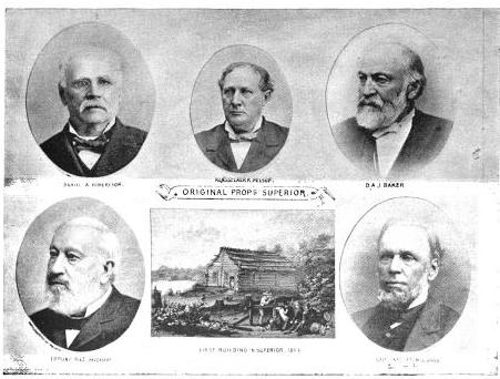
The Eye of the Northwest, pg. 8: James Stinson; Benjamin Thompson; W. W. Corcoran; U. S. Senator Robert J Walker; George W Cass; and Horace S Walbridge.
Five or six years ago a few American pioneers – stalwart backwoodsmen, undertook to select a town site out here, and did select one in good faith, and with clubs and muskets in had fought off from their premises a gang of Indians who were claiming to preëmpt it as “American citizens.” The Indians, however, were backup up by a Canadian white man by the name of STINSON, and some of the great speculators who were engaged in another town enterprise alongside here, and this “Indian war” was protracted in the local and general Land Offices some two or three years, when Mr. M’CLELLAND, then Secretary of the Interior, made a final adjudication of all the legal questions involved in the controversy, and sent it back to the Land Office to ascertain and apply the facts to the law as settled, on great deliberation by himself and Mr. CUSHING.
More Proprietors of Superior from The Eye of the North-west
, pg. 9: [names are illegible]
Meanwhile the original settlers and occupants maintained their adverse possession against the Indians and all the world, and expended a good deal of money in erecting buildings and a pier, and in cutting out streets and in laying out their town, and in carrying on their litigation, which was by no means inexpensive. M’CLELLAND’s determination of the law in their favor encouraged them to go on and incur additional expenses ; and they parted with diverse interests in the town site, some by assignment to persons who advanced money, and some by sale on quit-claim to persons who covenanted to make improvements. They made application to the proper office to enter the site, and nobody objected but the Indians – and the Indians were nowhere. So things stood when the case went back to the General Land Office, and to Mr. Secretary THOMPSON. The worthy Secretary, for some cause altogether unaccountable, adopted the extraordinary (and under the decision of the Supreme Court illegal) course of reversing the final judgement of his predecessor in this very case, (an exercise of power entirely unheard of in a case of mere private right,) and of rejecting the claim of the original occupants and settlers, though it was not contested by somebody who had a better right.
You may well imagine that this decision excited no little astonishment here. All the land stealers looked upon Superior City as vacant ground. They thought the men who selected and settled the town site were outlawed, and had no interests. Some supposed that the Land Office would put the ground up at auction. A chap by the name of SWEETZER came on here fresh from the General Land Office, and undertook to lay Sioux scrip on the whole site. Another – one JOHN GRANT – made application to preëmpt a portion of the site – and, what is the most remarkable feature about this business, GRANT was permitted to enter it as a preëmptor, though it was notoriously a selected town site, and in the adverse possession of town claimants half a year before GRANT ever saw it. This outrage created a great excitement for a small place. The Register, Mr. DANIEL SHAW, excuses himself by saying that he was almost expressly ordered by HENDRICKS to issue the certificate to GRANT, but this we do not believe in these parts. SHAW is clever, and covers his tracks, but nobody here supposes that the Commissioner ever countenanced such a gross violation of a public statute, without a motive. And what motive could the Commissioner have?
But, besides these movements, one of the Indians – ROY by name, who was defeated as one of the claimants by preëmeption – is now seeking to locate his Chippewa scrip on the town-site, and it is supposed that the same influences which urged him as an American citizen will support his claim as an Indian. A white man by the name of KINGSBURY, encouraged by the disregard of law exhibited by the local office, has made a claim on another part of the town-site. This purports to have originated in the fourth year of a litigation between the town claimants and the illegal preëmptors, and is supposed to be stimulated and encouraged by the Register.![Vincent Roy, Jr., portrait from "Short biographical sketch of Vincent Roy, [Jr.,]" in Life and Labors of Rt. Rev. Frederic Baraga, by Chrysostom Verwyst, 1900, pages 472-476.](https://chequamegonhistory.com/wp-content/uploads/2016/03/vincent-roy-jr.jpg)
Subsequently to his original rejection of the town-site claim, Mr. Secretary THOMPSON issued instructions to permit the entry, and the County Judge made application on the 18th instant, under the law of the United States, May 23, 1844. On this being known, some of the persons heretofore claiming under the original settlers and occupants (who had selected the town and paid all the expenses of the settlement) came together and formed an organization as a city, under a recent law of Wisconsin, the object of which they declare to be secure to themselves a title from the United States to the lots they specially occupy, and to sell the balance to defray their expenses in entering and alloting the land! The men whose rights vested under the absolute decision of Secretary MCCLELLAND, and who did all that they could do to enter the land, and paid the money for it more than two years ago, – the men whose “respective INTERESTS” the statute of 1844 recognizes and was designed to protect, – these men are all ruled off the course, and the men claiming under them have conspired to divide the land and its proceeds among themselves.
Of course these iniquitous and illegal proceedings are all within the reach of the Courts – but they are the legitimate consequence of Mr. JACOB THOMPSON’s repeal of so much of the Preëmption Law of 1841 as excludes from preëmption those portions of the public lands that have been “selected as the site of a city or town.” Mr. THOMPSON has overruled all his predecessors, all the Attorney-General, all the local offices, all the lexicographers, and the English language generally, by deciding solemnly that “selection” does not mean “selection,” but means something else – or more particularly nothing at all. Because, says he, if adverse “selection” excluded a preëmptor, then a preëmptor might be excluded by a false allegation of selection. Was there ever such an argal since Dogberry’s time? The Secretary has discovered an equally efficient “dispensing power” with that of King JAMES of blessed memory, and one which his brethren in the Cabinet may use very efficiently, if Congress does not look into the subject and fix some limits to it. For now, not only the Secretary, but the Commissioner, and the Register and Receiver, all think that they are at liberty to treat the repeal by the Secretary as an effective nullification of the law of the land.
If Congress would amuse their leisure a little by looking at these land office operations on the verge of civilization, they would strike a placer of corruption. Let them open the books and call for the documents, and see what Dr. T. RUSH SPENSER, late Register of the Willow River District, says of his predecessor and successor, Mr. JOHN O. HENNING, and then ascertain by what influences HENNING has been reappointed, and SPENSER transferred to Superior. Let them find out what Receiver DEAN said of Register SHAW, and what Register SHAW said of Receiver DEAN, and why DEAN was dismissed and why SHAW was retained. It will be rare fun for somebody. The country ought to know something about the Land Offices, and such an investigation as this would enlighten the country very materially. I hope it will be made, and that the country will learn how it is that more land has been entered in this district by Indians, foreigners, and minors than by qualified preëmptors, and all for the benefit of a few favored speculators.
