1838 Arrests at La Pointe
April 4, 2024
Collected & edited by Amorin Mello
The legendary Gichi-miishen (Michel Cadotte, Sr.) passed away days before the 1837 Treaty of St Peters was signed. One year later his son Michel Cadotte, Jr. and son-in-law Lyman M. Warren were both publicly arrested at the 1838 Annuity Payments in La Pointe, clouding their families’ 1827 Deed for Old La Pointe and 1834 Reinvention of La Pointe.
Letters Received by the Office of Indian Affairs:
La Pointe Agency 1831-1839
National Archives Identifier: 164009310

April 6, 1836
from La Pointe Indian Sub-agency
via Fort Snelling
to Commissioner of Indian Affairs
Received May 21, 1838
Answered May 22, 1838
Lapointe
April 6, 1838
C. A. Harris Esq’r
Com’r In Affs
Sir
I take the liberty of addressing you to ask whether in your opinion there is a probability that my salary can be increased by an act of Congress, or otherwise. I make this enquiry because I feel desirous of keeping this office, and unless the salary can be increased I shall be compelled to resign; the great distance of this place from any market and the expenses of transporting property hither, together [with] the prohibition of entering into trade rendering it at present altogether insufficient. A speedy answer is respectfully solicited.
I am sir with great
Respect your most obdt servant
D. P. Bushnell

American Fur Company public notice in newspapers nationwide about Lyman M. Warren being removed from La Pointe.

October 27, 1838
from Governor of Wisconsin Territory
to Commissioner of Indian Affairs
received November 19, 1838
Superintendency of Indian Affairs
for the Territory of Wisconsin
Mineral Point Oct. 27 1838.
Hon C. A. Harris
Com. of Ind. Affs.
Sir:

Henry Dodge
I have the honor to transmit the report of E. F. Ely, Esq. Sup’t of a school at Fond du Lac, Lake Superior, forwarded by Mr D. P. Bushnell, Sub agent at La Pointe, which had not been received at the time the other reports were transmitted.
Mr. Bushnell also informs me under date of the 18th Sept. that he has caused Lyman M. Warren, an American citizen, and Michel Cadotte, a half-breed, to be removed from the Indian Country, and has furnished the Dist. Attorney at Green Bay with the necessary evidence and requested him to commence suits against them, for violations of the 12th, 13th & 15th Sections of the act of June 30, 1834. Mr Warren is now here, and suits have been instituted upon the representations of the sub-agent. Further information will be furnished to you as soon as received.
Very respectfully
Your obed’t serv’t
Henry Dodge
Supt Ind. Affs

November 23, 1838
from Lyman M. Warren of La Pointe
via Governor of Wisconsin Territory
to Commissioner of Indian Affairs
Received December 15, 1838
Answered December 22, 1838
Superintendency of Indian Affairs
for the Territory of Wisconsin
Mineral Point Nov 23, 1838.
T. Hartley Crawford Esq’r
Com. of Indian Affairs
Washington
Sir:

Copy of 1834 “Map of La Pointe” by Lyman M. Warren.
I have the honor to transmit enclosed herewith, a communication from Lyman M. Warren, recently of La Pointe, Lake Superior, who, upon charges of a violation of the 12th, 13th & 15th Sections of the “Act to regulate trade and intercourse with the Indian tribes &c,” was removed from the Indian Country. Mr Warren has been long in the service of the American Fur Company at that post, and extensively engaged in Indian trade; and, from the hurried manner in which he was taken from the country, much of his business remains unsettled. He now asks from the Department, for the reasons given in his letter, that he be permitted to return to La Pointe next Spring for the purpose only of settling his business; an indulgence which I think may be safely granted. Mr Warren was the bearer of the information to the Dist. Attorney of the United States at this place, upon which suits were instituted against him, which fact, with that of his previous good standing and the respectability of his connection in this Territory, warrants me in the opinion that no detriment can arise to the Government from a compliance with his request. I have also consulted with the Sub-agent at that station, Mr. Bushnell, who admits the propriety of permitting him to return to the country, for the purposes expressed in his letter, if the agent be not absent. In case the Department should feel disposed to accede to his request, it would be well to instruct the District Attorney not to take any advantage of his absence at the Spring term of the Court, at which he is recognized to answer.
Very respectfully
Your obed’t Servant
Henry Dodge
Supt. Ind. Affs.
Prairie du Chein 7th Nov. 1838
To His Excellency
Henry Doge
Governor of Wisconsin
And Superintendent of
Indian affairs
Sir
Since Michel Cadotte and myself have arrived at this place and been served with process in the various suits brought against us in the name of the United States and given bail for our appearance at the May Term of the Crawford District Court in the Cases where bail was required, I have thought proper to address your Excellency in relation to the course that has been taken against me, and to request through your Excellency, some indulgence from the Department in the management of the Cases from the peculiar circumstances of my situation.
Your Excellency is aware that I was arrested at Lapointe on Lake Superior among the Chippewa Indians by a Military force, without legal process, and brought from thence by the way of the Sault Ste Marys, Mackinac and Green Bay to Fort Winebago from which place I came voluntarily and brought to the complaint against me to your Excellency that after giving bail in one Case at Mineral Point I came to this place whither the Deputy Marshall was sent to execute other process on me and Michel Cadotte. I was arrested and brought away from Lapointe at a time when private business of the greatest importance required my presence there, and my arrest and removal and consequent losses have almost ruined me. On my way I was robbed of upwards of One Thousand Dollars in Cash which is one of the consequences to me of the proceedings that have been commenced against me. I believe that your Excellency is fully aware that if I had been disposed to disregard the laws and authorities of the Country and to set them at defiance the force which was sent for me was not sufficient to bring me away. In fact the Indians in the vicinity were disposed to resists and to prevent my removal, and would have done so if I had not used my influence to restrain them. I mention this as an evidence of my disposition to submit to the laws and authorities of the Government, rather than to oppose or violate either.
I have been a Trader in extensive business among the Chippeways on Lake Superior for upwards of twenty one years, an can appeal with confidence to all intelligent Gentlemen who have been acquainted with my course of conduct throughout that period for testimony that I have always conformed my conduct to the laws of Congress, and the regulations of the Department, when known and understood. I have never knowingly violated either, and if I have ever in any case gone contrary to either, it has been when the law or regulation had not been made known at my remote and far distant station.
No one could expect that so far removed as I have been from settlements and civilization with so little intercourse with either, I could be so well and promptly made acquainted with the legislation and regulations of the Government as those who enjoyed the advantage of a residence within the more immediate sphere of its action and opperations. In the present Case I feel perfectly conscious, that I am free from all blame, and believe that it will be found upon investigation, that the proceedings against me originated in malice.
It is expected I believe that the Half breeds of the Chippeways on Lake Superior will be paid their share of the money donated to them by Treaty, some time early next Spring. It is of great importance to me and to others that I should be present at that payment. I have of my own a large family of children who are interested in the expected payment. Besides I am guardian of an estate which will require my personal presence at that place, in order that it may be settled.
Cadotte is also interested in the payment on his own account, and that of his children. It will be impossible for us to go up in the Spring and return to the Spring terms of the Court at Mineral Point and this place. I would therefore request it as a favor of the Department, if sufficient reason does not appear for dismissing the prosecutions altogether, that I may be permitted with Cadotte to attend at La Pointe in the next Spring season at the contemplated payment, or when ever the same may be made, and that no steps may be taken in the prosecution of the suits against us in our absence, and that the Attorney for the Territory may be directed not to take any default against us in any of the Cases either for want of bail, or plea, or other necessary propositions for our defense, while we may be absent on such business.
I hope that your Excellency will perceive the great importance to me of obtaining this indulgence, and sufficient reason to induce the kind interposition of your Excellency’s good offices to have it granted to me.
With great respect
I am your
Excellency’s Obedient Servant
L. M. Warren
W.718.

December 15, 1838
from Solicitor of the Treasury
to Commissioner of Indian Affairs
Received December 17, 1838
Answered December 22, 1838
and returned papers
from US Attorney Moses McCure Strong
dated November 25, 1838
Office of the Solicitor
of the Treasury
December 15, 1838
T. H. Crawford Esqr.
Comm’r of Indian Affairs.
Sir,
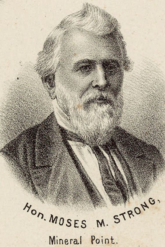
Moses McCure Strong
~ 1878 Historical Atlas of Wisconsin
I have the honor to inclose to you herewith a letter received by this morning’s mail from Messr Strong, United States Attorney for the Territory of Wisconsin, with a copy of one addressed to him by D. P. Burchnell, Indian Sub-agent at Mineral Point, Wisconsin, in relation to sundry suits commenced by him, to recover the penalty incurred for the violation of the 12, 13, & 15 sections of the act of Congress of of 30 June 1834 intitled “an act to regulate trade and intercourse with indian tribes, and to procure peace on the frontiers.”; which suits he states were commenced at the request of Mr. Burchnell.
To enable me to reply to the District Attorney’s letter I shall be obliged by your informing me at your earliest convenience, whether you wish any particular [directions?] given to him on the subject. Please return the District Attorney’s letter with its inclosure.
very respectfully Yours
H. D. Gilpin
Solicitor of the Treasury
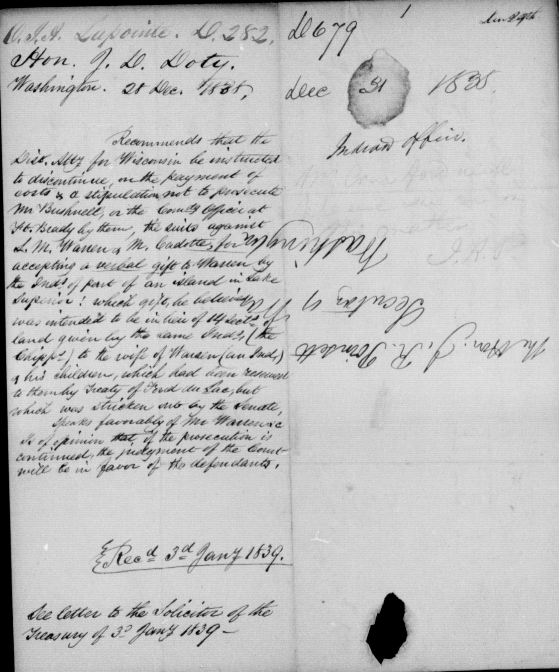
December 28, 1838
from James Duane Doty
to Commissioner of Indian Affairs
forwarded to Secretary of War December 31, 1838
Received January 3, 1839
See letter to Solicitor of the Treasury dated January 3, 1838.
Washington
Dec. 28 1838.
The Hon. J. R. Poinsett
Secy of War
Sir,

1827 Deed for Old La Pointe from Madeline and Michel Cadotte, Sr. to Lyman M. Warren for 2,000 acres of unceded tribal land on Madeline Island to be held in trust for the Cadotte/Warren grandchildren and future generations.
A prosecution was commenced last fall by the Indian Department against Lyman M. Warren, a licensed Trader at Lapointe, Lake Superior and a half Indian by the name of Michel Cadotte, for accepting of a verbal gift to Warren by the Indians of a part of an Island in Lake Superior. This gift I believe was intended to be in lieu of 14 sections of land given by the same Indians to the wife of Warren (an Indian woman, and his children, which had been reserved to them in the Treaty of Fond du Lac, but which was I am informed, stricken out, with other reservations of land, by the Senate.
It appears that Warren was ignorant of the act of Congress on this subject, and that so soon as he was informed, he desisted. Some months afterwards, and without anything new having secured, the sub-agent (then 300 miles from Lapointe) obtained a military force to be sent from Fort Brady to arrest Warren and his interpreter Cadotte. They made no resistance but voluntarily came with the soldiers to the Sault Ste Marie, and thence to Mineral Point 600 miles further.
Mr. Warren has been a Trader in that Country for the last 20 years, and I have personally known him there since the year 1820. During this long period he has been much respected as an upright Trader, submissive to the laws, and at all times disposed to extend the power of this government over the Northern Indians, who it is well known have been most inclined to visit and listen to the British authorities. I do not think there is another Indian Trader in the North West who has a greater influence with those Tribes than Mr. Warren.
The sub-agent, Mr. Bushnell, was a stranger in that country, but recently appointed, and, I cannot but think, has caused Mr. Warren to be arrested without a due examination of the facts of the case, or without giving a proper consideration to the effect it will be likely to have with the Indians of that country.
If Mr. Warren is compelled to defend this suit, whether it results in his favour or not, it must ruin him and his family, and I think the government will lose more than it will gain by continuing the prosecution.
From my knowledge of the parties, the facts of the case and the condition of the country I would respectfully recommend that the District Attorney be directed to discontinue the prosecutions against Warren & Cadotte upon the payment of costs and a stipulation not to prosecute Bushnell and the Commanding Officer at Fort Brady. I have no hesitation in expressing to you the opinion, that if the prosecution is continued the judgement of the Court will be in favour of the defendants.
With much respect I am Sir your obdt svt
J. D. Doty
1837 Petitions from La Pointe to the President
January 29, 2023
Collected & edited by Amorin Mello
Letters Received by the Office of Indian Affairs:
La Pointe Agency 1831-1839
National Archives Identifier: 164009310
O. I. A. La Pointe J171.
Hon Geo. W. Jones
Ho. of Reps. Jany 9, 1838
Transmits petition dated 31st Augt 1837, from Michel Cadotte & 25 other Chip. Half Breeds, praying that the amt to be paid them, under the late Chip. treaty, be distributed at La Pointe, and submitting the names of D. P. Bushnell, Lyman M. Warren, for the appt of Comsr to make the distribution.
Transmits it, that it may receive such attention as will secure the objects of the petitioners, says as the treaty has not been satisfied it may be necessary to bring the subject of the petition before the Comsr Ind Affrs of the Senate.
Recd 10 Jany 1838
file
[?] File.
House of Representatives Jany 9th 1838

Sir
I hasten to transmit the inclosed petition, with the hope, that the subject alluded to, may receive such attention, as to secure the object of the petitioners. As the Chippewa Treaty has not yet been ratified it may be necessary to bring the subject of the petition before the Committee of Indian Affairs of the Senate.
I am very respectfully
Your obt svt
Geo W. Jones
C. A. Harris Esqr
Comssr of Indian Affairs
War Department

To the President of the United States of America
The humble petition of the undersigned Chippewa Half-Breeds citizens of the United Sates, respectfully Shareth:

Bizhiki (Buffalo), Dagwagaane (Two Lodges Meet), and Jechiikwii’o (Snipe, aka Little Buffalo) signed the 1837 Treaty of St Peters for the La Pointe Band.
That, your petitioners having lately heard that a Treaty had been concluded between the Government of the United Sates and the Chippewa Indians at St Peters, for the cession of certain lands belonging to that tribe:
ARTICLE 3.
“The sum of one hundred thousand dollars shall be paid by the United States, to the half-
breeds of the Chippewa nation, under the direction of the President. It is the wish of the
Indians that their two sub-agents Daniel P. Bushnell, and Miles M. Vineyard, superintend
the distribution of this money among their half-breed relations.”
That, the said Chippewa Indians X, having a just regard to the interest and welfare of their Half Breed brethren, did there and then stipulate; that, a certain sum of money should be paid once for all unto the said Half-Breeds, to satisfy all claim they might have on the lands so ceded to the United States.
That, your petitioners are ignorant of the time and place where such payment is to be made.
That the great majority of the Half-Breeds entitled to a distribution of said sum of money, are either residing at La Pointe on Lake Superior, or being for the most part earning their livelihood from the Traders, are consequently congregated during the summer months at the aforesaid place.
Your petitioners humbly solicit their father the President, to take their case into consideration, and not subject them to a long and costly journey in ordering the payments to be made at any inconvenient distance, but on the contrary they trust that in his wisdom he will see the justice of their demand in requiring he will be pleased to order the same to be distributed at Lapointe agreeable to their request.
Your petitioners would also intimate that, although they are fully aware that the Executive will make a judicious choice in the appointment of the Commissioners who will be selected to carry into effect the Provisions of said Treaty, yet, they would humbly submit to the President, that they have full confidence in the integrity of D. P. Bushnell Esqr. resident Indian Agent for the United States at this place and Lyman M Warren Esquire, Merchant.
Your petitioners entertain the flattering hope, that, their petition will not be made in vain, and as in duty bound will ever pray.
La Pointe, Lake Superior,
Territory of Wisconsin 31st August 1837
Michel Cadotte
Michel Bosquet X his mark
Seraphim Lacombe X his mark
Joseph Cadotte X his mark
Antoine Cadotte X his mark
Chs W Borup for wife & Children
A Morrison for wife & children
Pierre Cotte
Henry Cotte X his mark
Frances Roussan X his mark
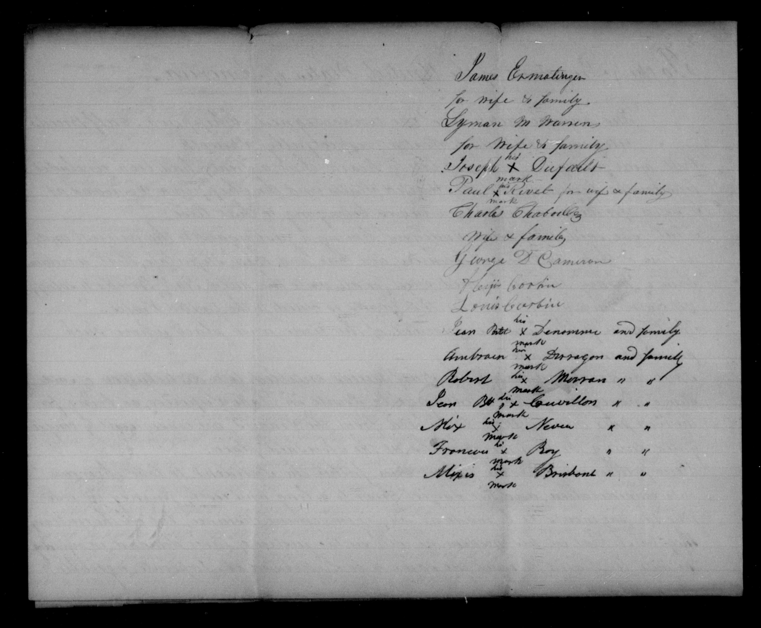
James Ermatinger for wife & family
Lyman M Warren for wife & family
Joseph Dufault X his mark
Paul Rivet X his mark for wife & family
Charles Chaboullez wife & family
George D. Cameron
Alixis Corbin
Louis Corbin
Jean Bste Denomme X his mark and family
Ambrose Deragon X his mark and family
Robert Morran X his mark ” “
Jean Bst Couvillon X his mark ” “
Alix Neveu X his mark ” “
Frances Roy X his mark ” “
Alixis Brisbant X his mark ” “
Signed in presence of G. Pauchene
John Livingston
O.I.A. La Pointe W424.
Governor of Wisconsin
Mineral Pt. Feby 19, 1838
Transmits the talk of “Buffalo,” a Chip. Chief, delivered at the La Pointe SubAgt, Dec. 9, 1837, asking that the am. due the half-breeds under the late Treaty, be divided fairly among them, & paid them there, as they will not go to St Peters for it, &c.
Says Buffalo has great influence with his tribe, & is friendly to the whites; his sentiments accord with most of those of the half-breeds & Inds in that part of the country.
File
Recd 13 March 1838
[?] File.
Superintendency of Indian Affairs
for the Territory of Wisconsin
Mineral Point, Feby 19, 1838
Sir,
I have the honor to inclose the talk of “Buffalo,” a principal chief of the Chippewa Indians in the vicinity of La Pointe, delivered on the 9th Dec’r last before Mr Bushnell, sub-agent of the Chippewas at that place. Mr. Bushnell remarks that the speech is given with as strict an adherence to the letter as the language will admit, and has no doubt the sentiments expressed by this Chief accord with those of most of the half-breeds and Indians in that place of the Country. The “Buffalo” is a man of great influence among his tribe, and very friendly to the whites.
Very respectfully,
Your obed’t sevt.
Henry Dodge
Supt Ind Affs
Hon C. A. Harris
Com. of Ind. Affairs
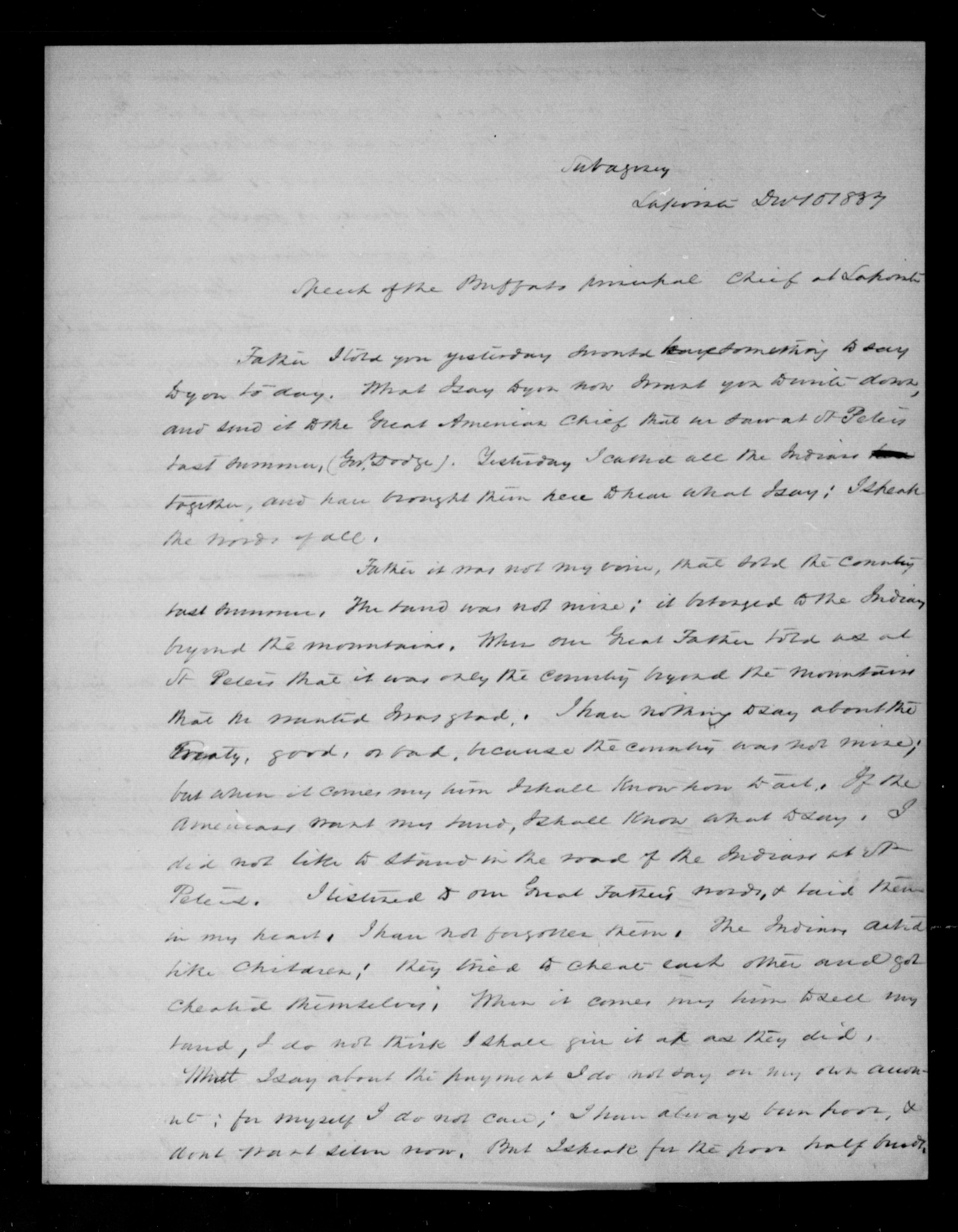
Subagency
Lapointe Dec 10 1837
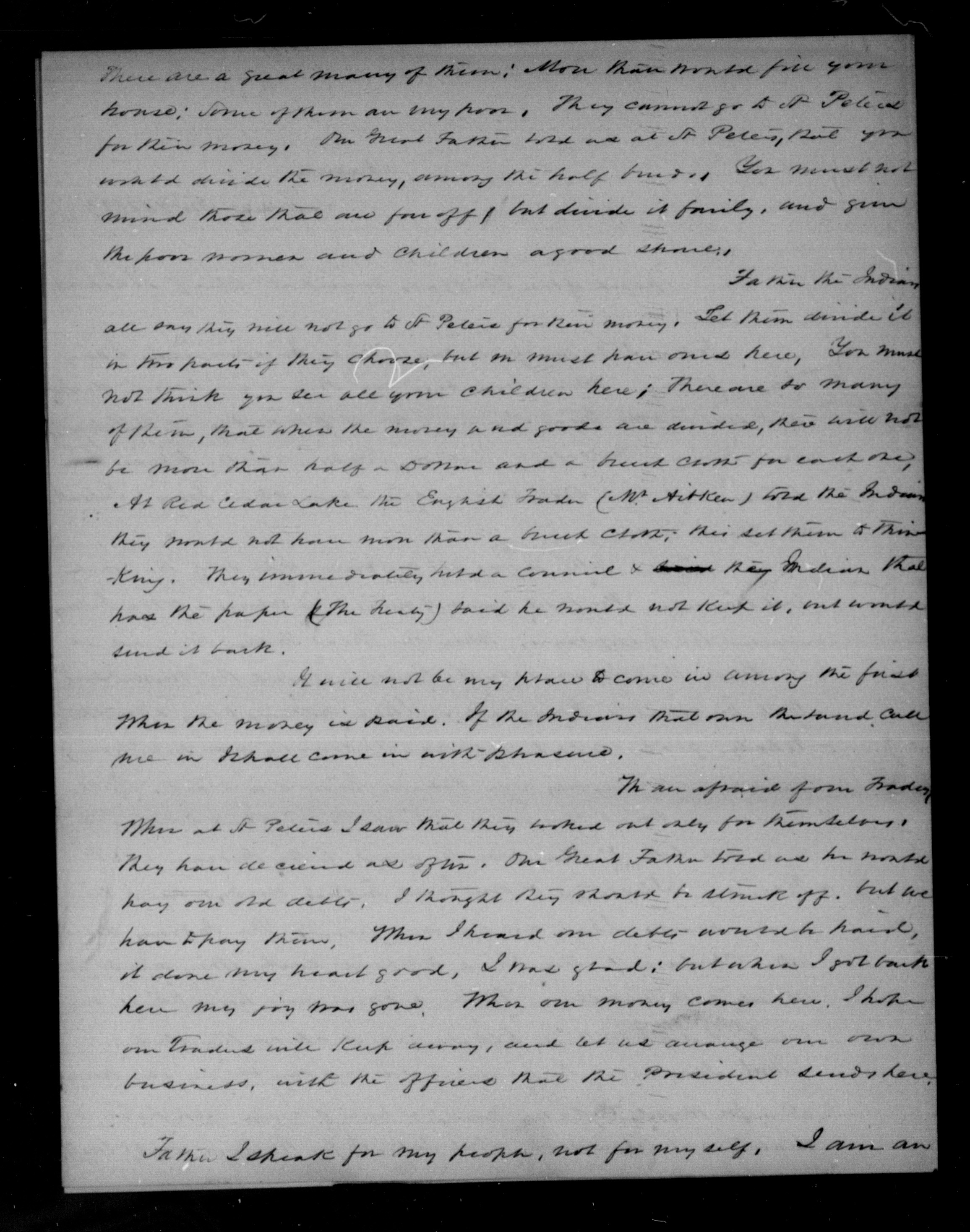
Speech of the Buffalo principal Chief at Lapointe
Father I told you yesterday I would have something to say to you today. What I say to you now I want you to write down, and send it to the Great American Chief that we saw at St Peters last summer, (Gov. Dodge). Yesterday, I called all the Indians together, and have brought them here to hear what I say; I speak the words of all.
ARTICLE 1.
“The said Chippewa nation cede to the United States all that tract of country included
within the following boundaries:
[…]
thence to and along the dividing ridge between the waters of Lake Superior and those of the Mississippi
[…]“
Father it was not my voice, that sold the country last summer. The land was not mine; it belonged to the Indians beyond the mountains. When our Great Father told us at St Peters that it was only the country beyond the mountains that he wanted I was glad. I have nothing to say about the Treaty, good, or bad, because the country was not mine; but when it comes my time I shall know how to act. If the Americans want my land, I shall know what to say. I did not like to stand in the road of the Indians at St Peters. I listened to our Great Father’s words, & said them in my heart. I have not forgotten them. The Indians acted like children; they tried to cheat each other and got cheated themselves. When it comes my time to sell my land, I do not think I shall give it up as they did.
What I say about the payment I do not say on my own account; for myself I do not care; I have always been poor, & don’t want silver now. But I speak for the poor half breeds.
There are a great many of them; more than would fill your house; some of them are very poor They cannot go to St Peters for their money. Our Great Father told us at St Peters, that you would divide the money, among the half breeds. You must not mind those that are far off, but divide it fairly, and give the poor women and children a good share.
Father the Indians all say they will not go to St Peters for their money. Let them divide it in this parts if they choose, but one must have ones here. You must not think you see all your children here; there are so many of them, that when the money and goods are divided, there will not be more than half a Dollar and a breech cloth for each one. At Red Cedar Lake the English Trader (W. Aitken) told the Indians they would not have more than a breech cloth; this set them to thinking. They immediately held a council & their Indian that had the paper (The Treaty) said he would not keep it, and would send it back.
It will not be my place to come in among the first when the money is paid. If the Indians that own the land call me in I shall come in with pleasure.
ARTICLE 4.
“The sum of seventy thousand dollars shall be applied to the payment, by the United States, of certain claims against the Indians; of which amount twenty eight thousand dollars shall, at their request, be paid to William A. Aitkin, twenty five thousand to Lyman M. Warren, and the balance applied to the liquidation of other just demands against them—which they acknowledge to be the case with regard to that presented by Hercules L. Dousman, for the sum of five thousand dollars; and they request that it be paid.“
We are afraid of one Trader. When at St Peters I saw that they worked out only for themselves. They have deceived us often. Our Great Father told us he would pay our old debts. I thought they should be struck off, but we have to pay them. When I heard our debts would be paid, it done my heart good. I was glad; but when I got back here my joy was gone. When our money comes here, I hope our Traders will keep away, and let us arrange our own business, with the officers that the President sends here.
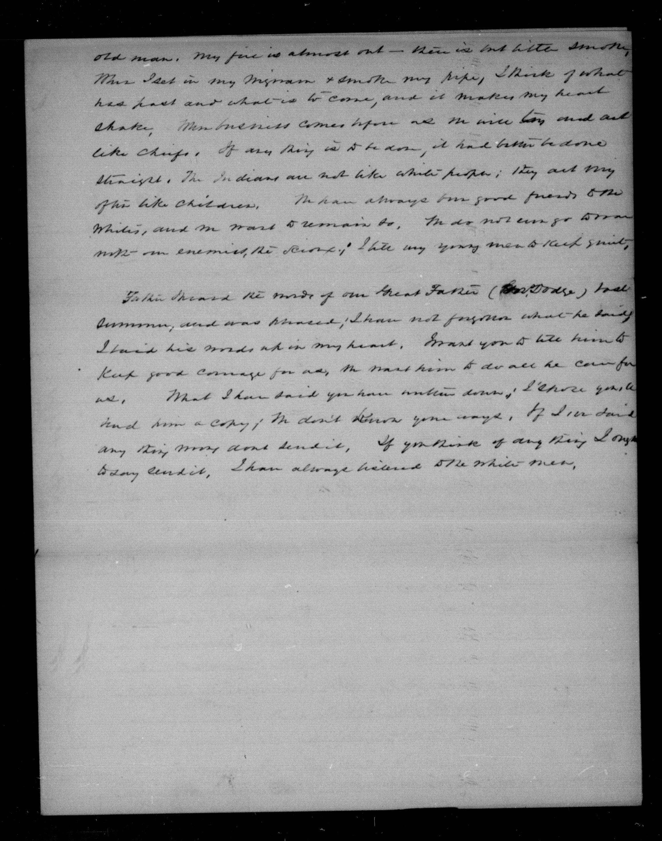
Father I speak for my people, not for myself. I am an old man. My fire is almost out – there is but little smoke. When I set in my wigwam & smoke my pipe, I think of what has past and what is to come, and it makes my heart shake. When business comes before us we will try and act like chiefs. If any thing is to be done, it had better be done straight. The Indians are not like white people; they act very often like children. We have always been good friends to the whites, and we want to remain so. We do not [even?] go to war with our enemies, the Sioux; I tell my young men to keep quiet.
Father I heard the words of our Great Father (Gov. Dodge) last summer, and was pleased; I have not forgotten what he said. I have his words up in my heart. I want you to tell him to keep good courage for us, we want him to do all he can for us. What I have said you have written down; I [?] you to hand him a copy; we don’t know your ways. If I [?] said any thing [?] dont send it. If you think of any thing I ought to say send it. I have always listened to the white men.
O.I.A. Lapointe, B.458
D. P. Bushnell
Lapointe, March 8, 1838
At the request of some of the petitioners, encloses a petition dated 7 March 1838, addressed to the Prest, signed by 167 Chip. half breeds, praying that the amt stipulated by the late Chip. Treaty to be paid to the half breeds, to satisfy all claims they ma have on the lands ceded by this Treaty, may be distributed at Lapointe.
Hopes their request will be complied with; & thinks their annuity should likewise be paid at Lapointe.
File
Recd 2nd May, 1838
Subagency
Lapointe Mch 6 1838
Sir
I have the honor herewith to enclose a petition addressed to the President of the United States, handed to me with a request by several of the petitioners that I would forward it. The justice of the demand of these poor people is so obvious to any one acquainted with their circumstances, that I cannot omit this occasion to second it, and to express a sincere hope that it will be complied with. Indeed, if the convenience and wishes of the Indians are consulted, and as the sum they receive for their country is so small, these should, I conciev, be principle considerations, their annuity will likewise as paid here; for it is a point more convenient of access for the different bands, that almost any other in their own country, and one moreover, where they have interests been in the habit of assembling in the summer months.
I am sir, with great respect,
your most obt servant,
D. P. Bushnell
O. I. A.
C. A. Harris Esqr.
Comr Ind. Affs
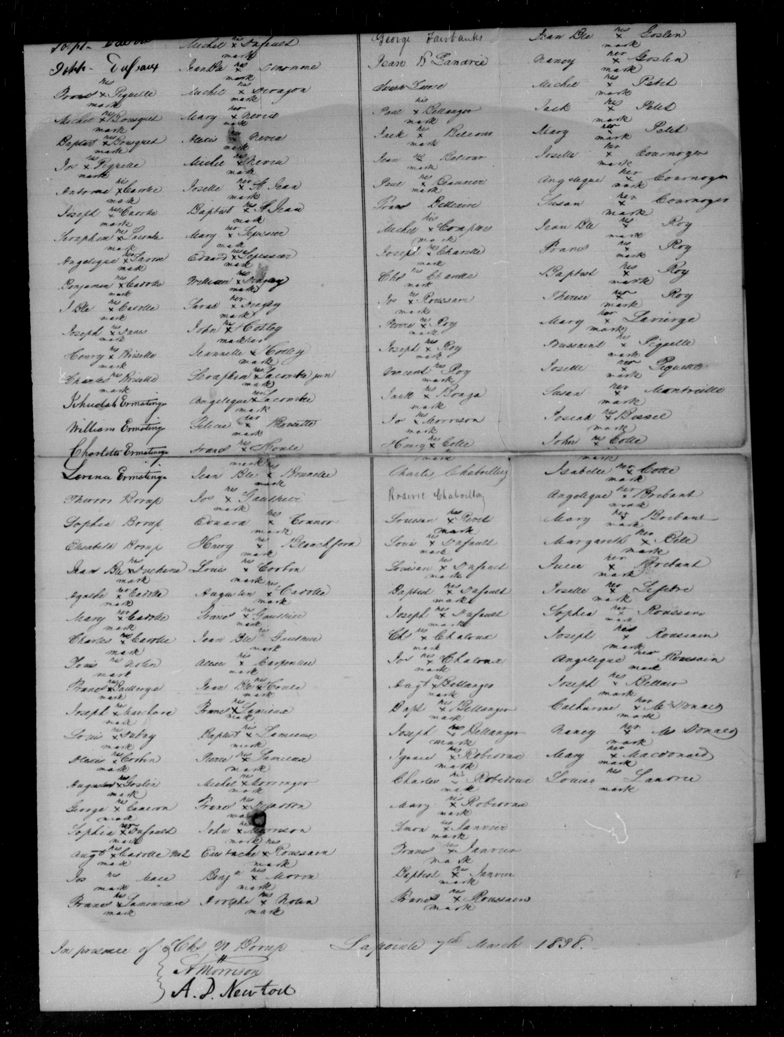
To the President of the United States of America
The humble petition of the undersigned Chippewa Half-Breeds citizens of the United States respectfully shareth
That your petitioners having lately heard, that a Treaty has been concluded between the Government of the United States and the Chippewa Indians at St Peters for the cession of certain lands belonging to that tribe;
That the said Chippewa Indians having a just regard to the interest and wellfare of their Half-Breed brethern, did there and then stipulate, that a certain sum of money should be paid once for all unto the said Half-Breeds, to satisfy all claims, they might have on the lands so ceded to the United States;
That your petitioners are ignorant of the time and place, where such payment is to be made; and
That the great majority of the Half-Breeds entitled to a portion of said sum of money are either residing at Lapointe on Lake Superior, or being for the most part earning their livelihood from the Traders, are consequently congregated during the summer months at the aforesaid place;
Your petitioners therefore humbly solicit their Father the President to take their case into consideration, and not subject them to a long and costly journey on ordering the payment to be made at any convenient distance, but on the contrary, they wish, that in his wisdom he will see the justice of this petition and that he will be pleased to order the same to be distributed at Lapointe agreeably to their request.
Your petitioners entertain the flattering hope, that their petition will not be made in vain and as in duly bound will ever pray.
Half Breeds of Folleavoine Lapointe Lac Court Oreilles and Lac du Flambeau
Georg Warren
Edward Warren
William Warren
Truman A Warren
Mary Warren
Michel Cadott
Joseph Cadotte
Joseph Dufault
Frances Piquette X his mark
Michel Bousquet X his mark
Baptiste Bousquet X his mark
Jos Piquette X his mark
Antoine Cadotte X his mark
Joseph Cadotte X his mark
Seraphim Lacombre X his mark
Angelique Larose X her mark
Benjamin Cadotte X his mark
J Bte Cadotte X his mark
Joseph Danis X his mark
Henry Brisette X his mark
Charles Brisette X his mark
Jehudah Ermatinger
William Ermatinger
Charlotte Ermatinger
Larence Ermatinger
Theodore Borup
Sophia Borup
Elisabeth Borup
Jean Bte Duchene X his mark
Agathe Cadotte X her mark
Mary Cadotte X her mark
Charles Cadotte X his mark
Louis Nolin _ his mark
Frances Baillerge X his mark
Joseph Marchand X his mark
Louis Dubay X his mark
Alexis Corbin X his mark
Augustus Goslin X his mark
George Cameron X his mark
Sophia Dufault X her mark
Augt Cadotte No 2 X his mark
Jos Mace _ his mark
Frances Lamoureau X his mark
Charles Morrison
Charlotte L. Morrison
Mary A Morrison
Margerike Morrison
Jane Morrison
Julie Dufault X her mark
Michel Dufault X his mark
Jean Bte Denomme X his mark
Michel Deragon X his mark
Mary Neveu X her mark
Alexis Neveu X his mark
Michel Neveu X his mark
Josette St Jean X her mark
Baptist St Jean X his mark
Mary Lepessier X her mark
Edward Lepessier X his mark
William Dingley X his mark
Sarah Dingley X her mark
John Hotley X his mark
Jeannette Hotley X her mark
Seraphim Lacombre Jun X his mark
Angelique Lacombre X her mark
Felicia Brisette X her mark
Frances Houle X his mark
Jean Bte Brunelle X his mark
Jos Gauthier X his mark
Edward Connor X his mark
Henry Blanchford X his mark
Louis Corbin X his mark
Augustin Cadotte X his mark
Frances Gauthier X his mark
Jean Bte Gauthier X his mark
Alexis Carpentier X his mark
Jean Bte Houle X his mark
Frances Lamieux X his mark
Baptiste Lemieux X his mark
Pierre Lamieux X his mark
Michel Morringer X his mark
Frances Dejaddon X his mark
John Morrison X his mark
Eustache Roussain X his mark
Benjn Morin X his mark
Adolphe Nolin X his mark
Half-Breeds of Fond du Lac
John Aitken
Roger Aitken
Matilda Aitken
Harriet Aitken
Nancy Scott
Robert Fairbanks
George Fairbanks
Jean B Landrie
Joseph Larose
Paul Bellanges X his mark
Jack Belcour X his mark
Jean Belcour X his mark
Paul Beauvier X his mark
Frances Belleaire
Michel Comptois X his mark
Joseph Charette X his mark
Chl Charette X his mark
Jos Roussain X his mark
Pierre Roy X his mark
Joseph Roy X his mark
Vincent Roy X his mark
Jack Bonga X his mark
Jos Morrison X his mark
Henry Cotte X his mark
Charles Chaboillez
Roderic Chaboillez
Louison Rivet X his mark
Louis Dufault X his mark
Louison Dufault X his mark
Baptiste Dufault X his mark
Joseph Dufault X his mark
Chs Chaloux X his mark
Jos Chaloux X his mark
Augt Bellanger X his mark
Bapt Bellanger X his mark
Joseph Bellanger X his mark
Ignace Robidoux X his mark
Charles Robidoux X his mark
Mary Robidoux X her mark
Simon Janvier X his mark
Frances Janvier X his mark
Baptiste Janvier X his mark
Frances Roussain X his mark
Therese Rouleau X his mark
Joseph Lavierire X his mark
Susan Lapointe X her mark
Mary Lapointe X her mark
Louis Gordon X his mark
Antoine Gordon X his mark
Jean Bte Goslin X his mark
Nancy Goslin X her mark
Michel Petit X his mark
Jack Petit X his mark
Mary Petit X her mark
Josette Cournoyer X her mark
Angelique Cournoyer X her mark
Susan Cournoyer X her mark
Jean Bte Roy X his mark
Frances Roy X his mark
Baptist Roy X his mark
Therese Roy X her mark
Mary Lavierge X her mark
Toussaint Piquette X his mark
Josette Piquette X her mark
Susan Montreille X her mark
Josiah Bissel X his mark
John Cotte X his mark
Isabelle Cotte X her mark
Angelique Brebant X her mark
Mary Brebant X her mark
Margareth Bell X her mark
Julie Brebant X her mark
Josette Lefebre X her mark
Sophia Roussain X her mark
Joseph Roussain X his mark
Angelique Roussain X her mark
Joseph Bellair X his mark
Catharine McDonald X her mark
Nancy McDonald X her mark
Mary Macdonald X her mark
Louise Landrie X his mark
In presence of
Chs W Borup
A Morrison
A. D. Newton
Lapointe 7th March 1838
1827 Deed for Old La Pointe
December 27, 2022
Collected & edited by Amorin Mello
Chief Buffalo and other principal men for the La Pointe Bands of Lake Superior Chippewa began signing treaties with the United States at the 1825 Treaty of Prairie Du Chien; followed by the 1826 Treaty of Fond Du Lac, which reserved Tribal Trust Lands for Chippewa Mixed Bloods along the St. Mary’s River between Lake Superior and Lake Huron:
ARTICLE 4.
The Indian Trade & Intercourse Act of 1790 was the United States of America’s first law regulating tribal land interests:
SEC. 4. And be it enacted and declared, That no sale of lands made by any Indians, or any nation or tribe of Indians the United States, shall be valid to any person or persons, or to any state, whether having the right of pre-emption to such lands or not, unless the same shall be made and duly executed at some public treaty, held under the authority of the United States.
It being deemed important that the half-breeds, scattered through this extensive country, should be stimulated to exertion and improvement by the possession of permanent property and fixed residences, the Chippewa tribe, in consideration of the affection they bear to these persons, and of the interest which they feel in their welfare, grant to each of the persons described in the schedule hereunto annexed, being half-breeds and Chippewas by descent, and it being understood that the schedule includes all of this description who are attached to the Government of the United States, six hundred and forty acres of land, to be located, under the direction of the President of the United States, upon the islands and shore of the St. Mary’s river, wherever good land enough for this purpose can be found; and as soon as such locations are made, the jurisdiction and soil thereof are hereby ceded. It is the intention of the parties, that, where circumstances will permit, the grants be surveyed in the ancient French manner, bounding not less than six arpens, nor more than ten, upon the river, and running back for quantity; and that where this cannot be done, such grants be surveyed in any manner the President may direct. The locations for Oshauguscodaywayqua and her descendents shall be adjoining the lower part of the military reservation, and upon the head of Sugar Island. The persons to whom grants are made shall not have the privilege of conveying the same, without the permission of the President.
The aforementioned Schedule annexed to the 1826 Treaty of Fond du Lac included (among other Chippewa Mixed Blood families at La Pointe) the families of Madeline & Michel Cadotte, Sr. and their American son-in-laws, the brothers Truman A. Warren and Lyman M. Warren:
-
To Michael Cadotte, senior, son of Equawaice, one section.
-
To Equaysay way, wife of Michael Cadotte, senior, and to each of her children living within the United States, one section.
-
To each of the children of Charlotte Warren, widow of the late Truman A. Warren, one section.
-
To Ossinahjeeunoqua, wife of Michael Cadotte, Jr. and each of her children, one section.
-
To each of the children of Ugwudaushee, by the late Truman A. Warren, one section.
-
To William Warren, son of Lyman M. Warren, and Mary Cadotte, one section.

Detail of Michilimackinac County circa 1818 from Michigan as a territory 1805-1837 by C.A. Burkhart, 1926.
~ UW-Milwaukee Libraries
Now, if it seems odd for a Treaty in Minnesota (Fond du Lac) to give families in Wisconsin (La Pointe) lots of land in Michigan (Sault Ste Marie), just remember that these places were relatively ‘close’ to each other in the sociopolitical fabric of Michigan Territory back in 1827. All three places were in Michilimackinac County (seated at Michilimackinac) until 1826, when they were carved off together as part of the newly formed Chippewa County (seated at Sault Ste Marie). Lake Superior remained Unceded Territory until later decades when land cessions were negotiated in the 1836, 1837, 1842, and 1854 Treaties.
Ultimately, the United States removed the aforementioned Schedule from the 1826 Treaty before ratification in 1827.
Several months later, at Michilimackinac, Madeline & Michel Cadotte, Sr. recorded the following Deed to reserve 2,000 acres surrounding the old French Forts of La Pointe to benefit future generations of their family.
Register of Deeds
Michilimackinac County
Book A of Deeds, Pages 221-224
Michel Cadotte and
Magdalen Cadotte
to
Lyman M. Warren
~Deed.
Received for Record
July 26th 1827 at two Six O’Clock A.M.
J.P. King
Reg’r Probate

Bizhiki (Buffalo), Gimiwan (Rain), Kaubuzoway, Wyauweenind, and Bikwaakodowaanzige (Ball of Dye) signed the 1826 Treaty of Fond Du Lac as the Chief and principal men of La Pointe.
“Copy of 1834 map of La Pointe by Lyman M. Warren“ at Wisconsin Historical Society. Original map (not shown here) is in the American Fur Company papers of the New York Historical Society.
Whereas the Chief and principal men of the Chippeway Tribe of indians, residing on and in the parts adjacent to the island called Magdalen in the western part of Lake Superior, heretofore released and confirmed by Deed unto Magdalen Cadotte a Chippeway of the said tribe, and to her brothers and sisters as tenants in common, thereon, all that part of the said Island called Magdalen, lying south and west of a line commencing on the eastern shore of said Island in the outlet of Great Wing river, and running directly thence westerly to the centre of Sandy bay on the western side of said Island;
and whereas the said brothers and sisters of said Magdalen Cadotte being tenants in common of the said premises, thereafterwards, heretofore, released, conveyed and confirmed unto their sister, the said Magdalen Cadotte all their respective rights title, interest and claim in and to said premises,
and whereas the said Magdalen Cadotte is desirous of securing a portion of said premises to her five grand children viz; George Warren, Edward Warren and Nancy Warren children of her daughter Charlotte Warren, by Truman A. Warren late a trader at said island, deceased, and William Warren and Truman A. Warren children of her daughter Mary Warren by Lyman M. Warren now a trader at said Island;
and whereas the said Magdalen Cadotte is desirous to promote the establishment of a mission on said Island, by and under the direction, patronage and government of the American board of commissioners for foreign missions, according to the plan, wages, and principles and purposes of the said Board.

William Whipple Warren was one of the beneficiary grandchildren named in this Deed.
Now therefore, Know all men by these presents that we Michael Cadotte and Magdalen Cadotte, wife of the said Michael, of said Magdalen Island, in Lake Superior, for and in consideration of one dollar to us in hand paid by Lyman M. Warren, the receipt whereof is hereby acknowledged, and for and in consideration of the natural love and affection we bear to our Grandchildren, the said George, Edward, Nancy, William W., and Truman A. Warren, children of our said daughters Charlotte and Mary;
and the further consideration of our great desire to promote the establishment of a mission as aforesaid, under and by the direction, government and patronage of Board aforesaid, have granted, bargained, sold, released, conveyed and confirmed, and by these presents do grant, bargain, sell, release, convey and confirm unto the said Lyman M. Warren his heirs and assigns, out of the aforerecited premises and as part and parcel thereof a certain tract of land on Magdalen Island in Lake Superior, bounded as follows,
Detail of Ojibwemowin placenames on GLIFWC’s webmap.
that is to say, beginning at the most southeasterly corner of the house built and now occupied by said Lyman M. Warren, on the south shore of said Island between this tract and the land of the grantor, thence on the east by a line drawn northerly until it shall intersect at right angles a line drawn westerly from the mouth of Great Wing River to the Centre of Sandy Bay, thence on the north by the last mentioned line westward to a Point in said line, from which a line drawn southward and at right angles therewith would fall on the site of the old fort, so called on the southerly side of said Island; thence on the west by a line drawn from said point and parallel to the eastern boundary of said tract, to the Site of the old fort, so called, thence by the course of the Shore of old Fort Bay to the portage; thence by a line drawn eastwardly to the place of beginning, containing by estimation two thousand acres, be the same more or less, with the appurtenances, hereditaments, and privileges thereto belonging.
To have and to hold the said granted premises to him the said Lyman M. Warren his heirs and assigns: In Trust, Nevertheless, and upon this express condition, that whensoever the said American Board of Commissioners for foreign missions shall establish a mission on said premises, upon the plan, usages, principles and purposes as aforesaid, the said Lyman M. Warren shall forthwith convey unto the american board of commissioners for foreign missions, not less than one quarter nor more than one half of said tract herein conveyed to him, and to be divided by a line drawn from a point in the southern shore of said Island, northerly and parallel with the east line of said tract, and until it intersects the north line thereof.

Roughly 2,100 acres lies south of Middle Road.
And as to the residue of the said Estate, the said Lyman M. Warren shall divided the same equally with and amongst the said five children, as tenants in common, and not as joint tenants; and the grantors hereby authorize the said Lyman M. Warren with full powers to fulfil said trust herein created, hereby ratifying and confirming the deed and deeds of said premises he may make for the purpose ~~~
In witness whereof we have hereunto set our respective hands, this twenty fifth day of july A.D. one thousand eight hundred and twenty seven, of Independence the fifty first.
(Signed) Michel Cadotte {Seal}
Magdalen Cadotte X her mark {Seal}
Signed, Sealed and delivered
in presence of us }
Daniel Dingley
Samuel Ashman
Wm. M. Ferry
(on the third page and ninth line from the top the word eastwardly was interlined and from that word the three following lines and part of the fourth to the words “to the place” were erased before the signing & witnessing of this instrument.)
~~~~~~
Territory of Michigan }
County of Michilimackinac }
Be it known that on the twenty sixth day of July A.D. 1827, personally came before me, the subscriber, one of the Justices of the Peace for the County of Michilimackinac, Michel Cadotte and Magdalen Cadotte, wife of the said Michel Cadotte, and the said Magdalen being examined separate and apart from her said husband, each severally acknowledged the foregoing instrument to be their voluntary act and deed for the uses and purposes therein expressed.
(Signed) J. P. King
Just. peace
Cxd
fees Paid $2.25
By Leo
In April, the Supreme Court heard arguments in the case Department of Commerce v. New York and could render a decision any day on whether or not the 2020 federal census should include a question asking about citizenship status. In January, a Federal District Court in New York ruled that commerce secretary, Wilbur Ross, violated the law by pushing for that question.
Those in agreement with the District ruling suggest that the Trump administration wants to add the question as a way of discouraging immigrants from participating in the census, thereby diminishing the political power of immigrant communities. This, they say, would violate the Constitution on the grounds that the census must be an “actual enumeration” of all persons within the United States, not only citizens.
Proponents of the citizenship question counter that citizenship status is a perfectly natural question to ask in the census, that any government would want to know how many citizens it has, and that several past iterations of the 10-year count have included similar questions.
It remains to be seen how the Supreme Court will rule, but chances are it will not be the last time an issue of race, identity, or citizenship pops up in the politics of the census. From its creation by the Constitution as a way to apportion seats in congress according to populations of the states, the count has always begged tricky questions that essentially boil down to:
Who is a real American? Who isn’t? Who is a citizen? Who is three-fifths of a human being? Who might not be human at all? What does it mean to be White? To be Colored? To be civilized? How do you classify the myriad of human backgrounds, cultures and stories into finite, discrete “races?”
The Civil War and Fourteenth Amendment helped shed light on some of these questions, but it would be a mistake to think that they belong to the past. The NPR podcast Codeswitch has done an excellent series on census, and this episode from last August gives a broad overview of the history.
Here at Chequamegon History, though, we aren’t in the business broad overviews. We are going to drill down right into the data. We’ll comb through the 1850 federal census for La Pointe County and compare it with the 1860 data for La Pointe and Ashland Counties. Just for fun, we’ll compare both with the 1855 Wisconsin State Census for La Pointe County, then double back to the 1840 federal census for western St. Croix County. Ultimately, the hope is to help reveal how the population of the Chequamegon region viewed itself, and ultimately how that differed from mainstream America’s view. With luck, that will give us a framework for more stories like Amorin’s recent post on the killing of Louis Gurnoe.
Background
 Judge Daniel Harris Johnson of Prairie du Chien had no apparent connection to Lake Superior when he was appointed to travel northward to conduct the census for La Pointe County in 1850. The event made an impression on him. It gets a mention in his short memorial biography in the 1902 Proceedings of the State Bar Association.
Two years after statehood, Lake Superior’s connection to the rest of Wisconsin was hardly existent. This was long before Highways 51 and 53 were built, and commerce still flowed west to east. Any communication to or from Madison was likely to first go through Michigan via Mackinaw and Sault Ste. Marie, or through Minnesota Territory via St. Paul, Stillwater, and Sandy Lake. La Pointe County had been created in 1845, and when official business had to happen, a motley assortment of local residents who could read and write English: Charles Oakes, John W. Bell, Antoine Gordon, Alexis Carpentier, Julius Austrian, Leonard Wheeler, etc. would meet to conduct the business.
It is unclear how much notice the majority Ojibwe and French-patois speaking population took of this or of the census generally. To them, the familiar institutions of American power, the Fur Company and the Indian Agency, were falling apart at La Pointe and reorganizing in St. Paul with dire consequences for the people of Chequamegon. When Johnson arrived in September, the Ojibwe people of Wisconsin had already been ordered to remove to Sandy Lake in Minnesota Territory for their promised annual payments for the sale of their land. That fall, the government would completely botch the payment, and by February, hundreds of people in the Lake Superior Bands would be dead from starvation and disease.
So, Daniel Johnson probably found a great deal of distraction and anxiety among the people he was charged to count. Indians, thought of by the United States as uncivilized federal wards and citizens of their own nations, were typically not enumerated. However, as I wrote about in my last post, race and identity were complicated at La Pointe, and the American citizens of the Chequamegon region also had plenty to lose from the removal.
Madison, for its part, largely ignored this remote, northern constituency and praised the efforts to remove the Ojibwe from the state. It isn’t clear how much Johnson was paying attention to these larger politics, however. He had his own concerns:


House Documents, Volume 119, Part 1. U.S. Government Printing Office, 1859. Google Books.
So, in “that thinly settled and half civilized region,” Johnson only found a population of about 500, “exclusive of Indians.” He didn’t think 500 was a lot, but by some counts, that number would have seemed very high. Take the word of a European visitor to La Pointe:
Among 200 Indians, only a few white families live there. One of the boatmen gave us a name, with which we found Mr. Austrian.
And, from this Mr. Austrian, himself:
There were only about 6 white American inhabitants on the Island, about 50 Canadian Frenchmen who were married to squaws, and a number of full blooded Indians, among whom was chief Buffalo who was a descendant of chiefs & who was a good Indian and favorably regarded by the people.
~Joseph Austrian, Brother of Julius and La Pointe resident 1851-52
Who lived around La Pointe in 1850?
In her biography, William W. Warren: the Life, Letters, and Times of an Ojibwe Leader, Theresa Schenck describes the short life of an ambitious young man from La Pointe. William Whipple Warren (1825-1853) grew up on the Island speaking Ojibwe as his first language. His father was a Yankee fur trader from New York. His mother was a daughter of Michel and Madeline Cadotte. In his famous History of the Ojibways Warren describes the Ojibwe as people with whom he readily claims kinship, but he doesn’t write as if he is an Ojibwe person himself. However, he helped interpret the Treaty of 1847 which had definitively made him an Indian in the eyes of the United States (a fact he was willing to use for economic gain). Still, a few years later, when he became a legislator in Minnesota Territory he dismissed challenges to his claims of whiteness.
If he were alive today, Warren might get a chuckle out of this line from the South African comedian Trevor Noah.
People mocked me. Gave me names like mixed breed, half caste — I hate that term ‘half’. Why half? Why not double? Or twice as nice, I don’t know.
— Trevor Noah
William Warren did not see himself as quite the walking contradiction we might see him as today. He was a product of the time and place he came from: La Pointe. By 1850, he had left that place, but his sister and a few hundred of his cousins still lived there. Many of them were counted in the census.
What is Metis?
Half-breeds, Mixed-bloods, Frenchmen, Wiisakodewininiwag, Mitif, Creoles, Metis, Canadiens, Bois Brules, Chicots, French-of-the-country, etc.–at times it seems each of these means the same thing. At other times each has a specific meaning. Each is ambiguous in its own way. In 1850, roughly half the families in the Chequamegon area fit into this hard-to-define category.


Kohl, J. G. Kitchi-Gami: Wanderings around Lake Superior. London: Chapman and Hall, 1860. pg. 260-61.
We were accompanied on our trip throughout the lakes of western Canada by half-Indians who had paternal European blood in their veins. Yet so often, a situation would allow us to spend a night inside rather than outdoors, but they always asked us to choose to Irish camp outside with the Indians, who lived at the various places. Although one spoke excellent English, and they were drawn more to the great American race, they thought, felt, and spoke—Indian! ~Carl Scherzer
In describing William Warren’s people, Dr. Schenck writes,
Although the most common term for people of mixed Indian and European ancestry in the nineteenth century was “half-breed,” the term “mixed blood” was also used. I have chosen to use the latter term, which is considered less offensive, although biologically inaccurate, today. The term “métis” was not in usage at the time, except to refer to a specific group of people of mixed ancestry in the British territories to the north. “Wissakodewinini,” the word used by the Ojibwe, meant “burned forest men,” or bois brulés in French, so called because half-breeds were like the wood of a burned forest, which is often burned on one side, and light on the other (pg. xv).
Schenck is correct in pointing out that mixed-blood was far more commonly used in 19th-century sources than Metis (though the latter term did exist). She is also correct in saying that the term is more associated with Canada and the Red River Country. There is an additional problem with Metis, in that 21st-century members of the Wannabe Tribe have latched onto the term and use it, incorrectly, to refer to anyone with partial Native ancestry but with no affiliation to a specific Indian community.
That said, I am going to use Metis for two reasons. The first is that although blood (i.e. genetic ancestry) seemed to be ubiquitous topic of conversation in these communities, I don’t think “blood” is what necessarily what defined them. The “pure-blooded French Voyageur” described above by Kohl clearly saw himself as part of Metis, rather than “blanc” society. There were also people of fully-Ojibwe ancestry who were associated more with Metis society than with traditional Ojibwe society (see my post from April). As such, I find Metis the more versatile and accurate term, given that it means “mixed,” which can be just as applicable to a culture and lifestyle as it is to a genetic lineage.

One time Canadian pariah turned national hero, Louis Riel and his followers had cousins at La Pointe (Photo: Wikipedia)
The second reason I prefer Metis is precisely because of the way it’s used in Manitoba. Analogous to the mestizo nations of Latin America, Metis is not a way of describing any person with Native and white ancestry. The Metis consider themselves a creole-indigenous nation unto themselves, with a unique culture and history. This history, already two centuries old by 1850, represents more than simply a borrowed blend of two other histories. Finally, the fur-trade families of Red River came from Sault Ste. Marie, Mackinac, Grand Portage, and La Pointe. There were plenty of Cadottes, Defaults, Roys, Gurnoes, and Gauthiers among them. There was even a Riel family at La Pointe. They were the same nation
Metis and Ojibwe Identity in the American Era
When the 1847 Treaty of Fond du Lac “stipulated that the half or mixed bloods of the Chippewas residing with them shall be considered Chippewa Indians, and shall, as such, be allowed to participate in all annuities which shall hereafter be paid…” in many ways, it contradicted two centuries of tradition. Metis identity, in part, was dependent on not being Indian. They were a minority culture within a larger traditional Anishinaabe society. This isn’t to say that Metis people were necessarily ashamed of their Native ancestors–expressions of pride are much easier to find than expressions shame–they were just a distinct people. This was supposedly based in religion and language, but I would argue it came mostly from paternal lineage (originating from highly-patriarchal French and Ojibwe societies) and with the nature of men’s work. For women, the distinction between Ojibwe and Metis was less stark.
The imposition of American hegemony over the Chequamegon region was gradual. With few exceptions, the Americans who came into the region from 1820 to 1850 were adult men. If new settlers wanted families, they followed the lead of American and British traders and married Metis and Ojibwe women.
Still, American society on the whole did not have a lot of room for the racial ambiguity present in Mexico or even Canada. A person was “white” or “colored.” Race mixing was seen as a problem that affected particular individuals. It was certainly not the basis for an entire nation. In this binary, if Metis people weren’t going to be Indian, they had to be white.
The story of the Metis and American citizenship is complicated and well-studied. There is risk of overgeneralizing, but let’s suffice to say that in relation to the United States government, Metis people did feel largely entitled to the privileges of citizenship (synonymous with whiteness until 1865), as well as to the privileges of Ojibwe citizenship. There wasn’t necessarily a contradiction.
Whatever qualms white America might have had if they’d known about it, Metis people voted in American elections, held offices, and were counted by the census.
Ojibwe “Full-bloods” and the United States Census
Representatives and direct Taxes shall be apportioned among the several States which
may be included within this Union, according to their respective Numbers, which shall be determined by adding to the whole Number of free Persons, including those bound to Service for a Term of Years, and excluding Indians not taxed, three fifths of all other Persons. The actual Enumeration shall be made within three Years after the first Meeting of the Congress of the United States, and within every subsequent Term of ten Years, in such Manner as they shall by Law direct.~Excerpt from Article I Section II, U. S. Constitution
As I argued in the April post, our modern conception of “full-blood” and “mixed-blood” has been shaped by the “scientific” racism of the late 19th and early 20th centuries. The distinction, while very real in a cultural sense, was not well-grounded in biology.
The relationship of Indians (i.e. full-bloods or those living a traditional lifestyle) to American society and citizenship was possibly more contradictory then that of the Metis. In one sense, America saw Indians as foreigners on their own continent: either as enemies to be exterminated, or as domestic-dependent ward nations to be “protected.” The constitutional language about the census calls for slaves to be counted as three-fifths of a person. It says Indians shouldn’t be counted at all.
In another sense, however, the path to personhood in America was somewhat clearer for Indians than it was for African Americans. Many New England liberals saw exodus to Liberia as the only viable future for free blacks. These same voices felt that Indians could be made white if only they were separated from their religions, cultures, and tribal identities. In 1834, to avoid a second removal, the Brothertown Indians of Wisconsin petitioned congress for citizenship and the termination of collective title to their tribal lands. In 1839, their request was granted. In the eyes of the law, they had effectively become white. Other communities would follow suit. However, most Native people did not gain any form of American citizenship until 1924.
How did that play out for the Ojibwe people of Chequamegon, and how did it impact the 1850 census? Well, it’s complicated.
Race, the Census, and Classifying Households
The enumeration forms Daniel H. Johnson carried to La Pointe had more rows and columns than ever. The Seventh Census was the first to count everyone in the household by name (previous versions only listed the Head of Household with tally marks). It was also the first census to have a box for “color.” Johnson’s choices for color were “white,” “black,” and “mulatto,” forcing him to make some decisions.
He seems to have tried to follow the Indians not taxed clause strictly. 40-50% of households in the region were headed by a full-blood Ojibwe person, possibly only two of them were enumerated. You won’t find Chief Buffalo, Makadebinesi (Blackbird), Oshkinaawe, Omizhinaawe, Edawegiizhig, and their immediate families in the 1850 census. Jechiikwii’o (often called Little Buffalo) is not in the document, even though he was an early Catholic convert, dressed in “white” clothing, and counted more Metis Ojibwe among his followers than full-bloods. However, his son, Antoine Buffalo Sr. (Antoine Jachequaon) is counted. Antoine, along with George Day, were counted as white heads of household by the census, though it is unclear if they had any European ancestry (Sources conflict. If anyone has genealogical information for the Buffalo and Day families, feel free to comment on the post). A handful of individuals called full-bloods in other sources, were listed as white. This includes 90-year old Madeline Cadotte, Marie Bosquet, and possibly the Wind sisters (presumably descendants of Noodin, one of the St. Croix chiefs who became Catholic and relocated to La Pointe around this time). They were married to Metis men or lived in Metis households. All Metis were listed as white.
Johnson did invent new category for five other Ojibwe people: “Civilized Indian,” which he seemed to use arbitrarily. Though also living in Metis households, Mary Ann Cadotte, Osquequa Baszina, Marcheoniquidoque, Charlotte Houle, and Charles Loonsfoot apparently couldn’t be marked white the way Madeline Cadotte was. These extra notations by Johnson and other enumeration marshals across the country are why the Seventh Federal Census is sometimes referred to as the first to count Native Americans.

So, out of 470 individuals enumerated at La Pointe and Bad River (I’ve excluded Fond du Lac from my study) Johnson listed 465 (99%) as white. By no definition, contemporary or modern, was the Chequamegon area 99% white in 1850. The vast majority of names on the lines had Ojibwe ancestry, and as Chippewas of Lake Superior, were receiving annuities from the treaties.
There were a few white American settlers. The Halls had been at La Pointe for twenty years. The Wheelers were well-established at Odanah. Junius and Jane Welton had arrived by then. George Nettleton was there, living with a fellow Ohioan James Cadwell. The infamous Indian agent, John Watrous, was there preparing the disastrous Sandy Lake removal. Less easy to describe as American settlers, but clearly of European origins, Fr. Otto Skolla was the Catholic priest, and Julius Austrian was the richest man it town.
There were also a handful of American bachelors who had drifted into the region and married Metis women. These first-wave settlers included government workers like William VanTassel, entrepreneurs like Peter VanderVenter, adventurers with an early connection to the region like Bob Boyd and John Bell, and homesteaders like Ervin Leihy.
It is unclear how many of French-surnamed heads of household were Chicots (of mixed ancestry) and how many were Canadiens (of fully-French ancestry). My sense is that it is about half and half. Some of this can be inferred from birthplace (though a birthplace of Canada could indicate across the river at Sault Ste. Marie as easily it could a farm in the St. Lawrence Valley). Intense genealogical study of each family might provide some clarifications, but I am going to follow Kohl’s voyageurs and not worry too much about it. Whether it was important or not to Jean Baptiste Denomie and Alexis Carpentier that they had no apparent Indian ancestry and that they had come from “the true homeland” of Quebec, for all intents and purposes they had spent their whole adult lives in “the Upper Country,” and their families were “of the Country.” They were Catholic and spoke a form of French that wasn’t taught in the universities. American society would not see them as white in the way it saw someone like Sherman Hall as white.
So, by my reckoning, 435 of the 470 people counted at La Pointe (92.5%) were Metis, full-blood Ojibwe living in Metis households, or Canadians in Metis families. Adding the five “Civilized Indians” and the six Americans married into Metis families, the number rises to 95%. I am trying to track down accurate data on the of Indians not taxed (i.e. non-enumerated full-bloods) living at or near La Pointe/Bad River at this time. My best estimates would put it roughly the same as the number of Metis. So, when Johnson describes a land with a language and culture foreign to English-speaking Americans, he’s right.
Birthplace, Age, and Gender
Ethnic composition is not the only data worth looking at if we want to know what this area was like 169 years ago. The numbers both challenge and confirm assumptions of how things worked.
Let’s take mobility for example:

The young voyageur quoted by Kohl may have felt like he didn’t have a home other than en voyage, but 86% of respondents reported being born in Wisconsin. Except for ten missionary children, all of these were Metis or “Civilized Indian.” Wisconsin could theoretically mean Lac du Flambeau, Rice Lake, or even Green Bay, this but this number still seemed high to me. I’m guessing more than 14% of 21st-century Chequamegon residents were born outside the state, and 19th-century records are all about commerce, long-distance travel, and new arrivals in new lands. We have to remember that most of those records are coming from that 14%.
In September of 1850 the federal government was telling the Ojibwe of Wisconsin they needed to leave Wisconsin forever. How the Metis fit into the story of the Sandy Lake Tragedy has always been somewhat fuzzy, but this data would indicate that for a clear majority, it meant a serious uprooting.
For those born outside Wisconsin, more than two-thirds reported being born in Michigan, Canada, or Minnesota Territory. These are overwhelmingly Metis or in the case of Anglo-Canadians like Robert Morrin, heads of Metis households from areas with a fur-trade tradition. Only eighteen individuals reported being born in the eastern United States. Only three reported Europe.
I had more questions than assumptions about the gender and age breakdown of the population. Would there be more women than men because of the dangerous jobs done by men or would mortality from childbirth balance that out? Or maybe widows wouldn’t be counted if they returned to the wigwams of their mothers? How would newcomers skew the age and gender demographics of the area?
Let’s take a look:
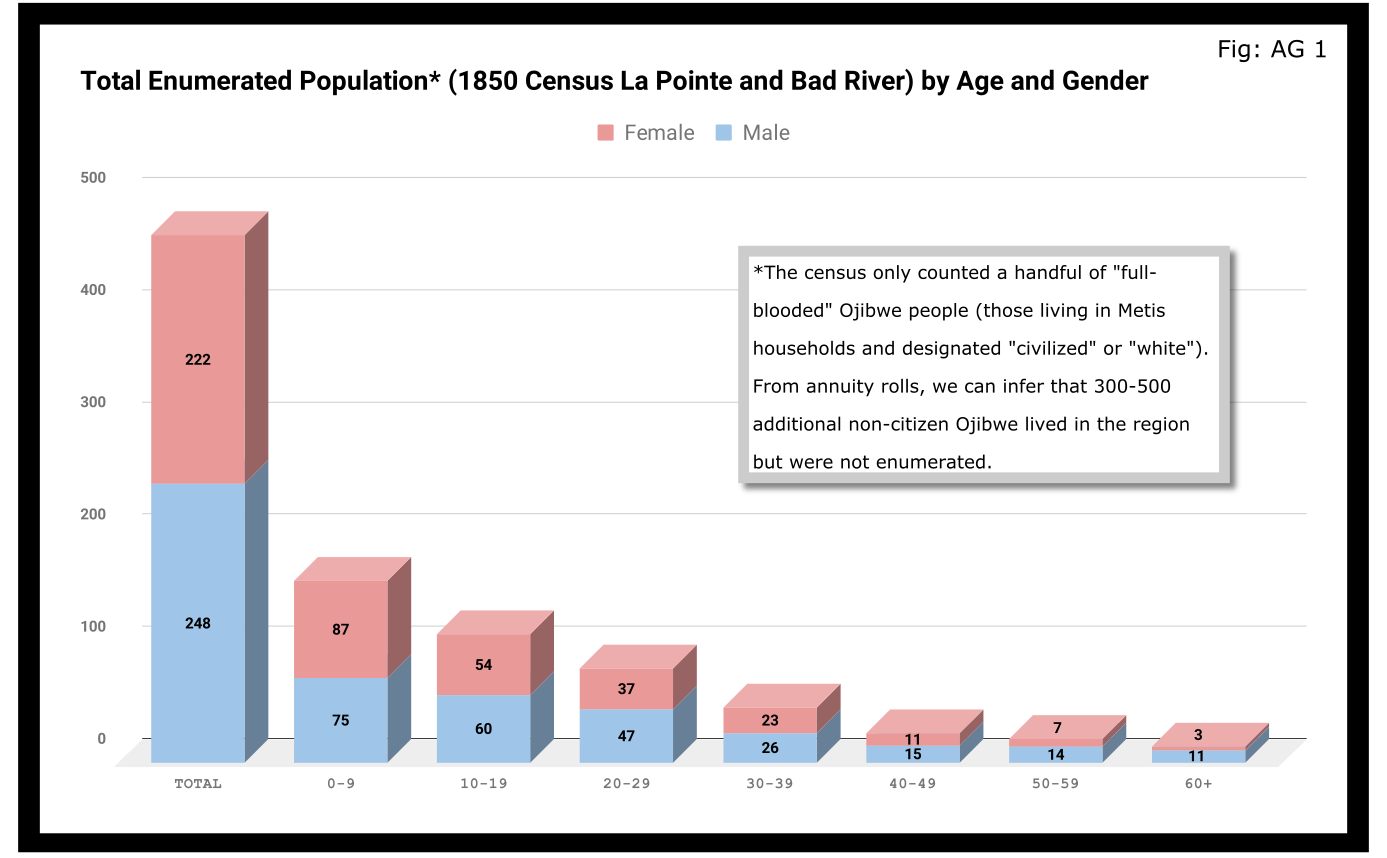
A quick glance at Figure AG 1 shows that the population skewed male 248-222 and skewed very young (61% under 20 years old). On the eve of Sandy Lake, the natural increase in the population seemed to be booming.

The hypotheses that women had higher mortality rates and were more likely to be undercounted looked good until we limit the data to the Wisconsin-born population. In Figure AG 2, we see that the male majority disappears entirely. The youthful trend, indicating large families and a growing population, continues with 66% of the Wisconsin-born population being under 20.

The male skew of the total population was entirely due to those born outside Wisconsin. This is not surprising given how much we’ve emphasized the number of men who came into the Lake Superior country to marry local women.
A look at the oldest residents in chart AG 2 and AG 3 hints at another story. Madeline Cadotte is the only Wisconsin-born person over seventy to be counted. The oldest men all came from Michigan and Canada. Why? My hypothesis is that between the fall of New France in 1759 and the establishment of Michel Cadotte’s post sometime around 1800, there wasn’t a large population or a very active fur trade around La Pointe proper. That meant Cadotte’s widow and other full bloods were the oldest locally-born residents in 1850. Their Metis contemporaries didn’t come over from the Soo or down from Grand Portage until 1810 or later.
Economics
Before the treaties, the economy of this area was built on two industries: foraging and trade. Life for Ojibwe people revolved around the seasonal harvest of fish, wild rice, game, maple sugar, light agriculture, and other forms of gathering food directly from the land. Trade did not start with the French, and even after the arrival of European goods into the region, the primary purpose of trade seemed to be for cementing alliances and for the acquisition of luxury goods and sacred objects. Richard White, Theresa Schenck, and Howard Paap have all challenged the myth of Ojibwe “dependence” on European goods for basic survival, and I find their arguments persuasive.
Trade, though, was the most important industry for Metis men and La Pointe was a center of this activity. The mid-19th century saw a steep decline in trade, however, to be replaced by a toxic cycle of debts, land sales, and annuity payments. The effects of this change on the Metis economy and society seem largely understudied. The fur trade though, was on its last legs. Again, the Austrian travel writer Carl Scherzer, who visited La Pointe in 1852:
After this discussion of the of the rates of the American Fur Company and its agents, we want to add some details about the men whose labor and time exerted such a great influence on the fate and culture of the Indian tribes. We wish to add a few explanatory words about the sad presence on La Pointe of the voyageurs or courriers du bois.
This peculiar class of people, which is like a vein of metal that suddenly disappears within the bedrock and reappears many hundreds of miles away under the same geological conditions, their light reaches the borders of the eastern Canadas. The British people, with their religion and customs, reappeared on the shores of these northern lakes only in 1808 with the Fur Company. For labor they drew on those who could carry their wares across the lakes and communicate with the Indians.
Many young men of adventurous natures left the old wide streets of Montreal and moved into the trackless primeval forests of the West. Young and strong as laborers, they soon started to adopt the lifestyle and language of the aborigines. They married with the Indians and inhabit small settlements scattered throughout those mighty lands which begin at Mackinow Island and come up the upper lake to the region of Minnesota. They almost all speak the Canadian patois along with the language of the Chippewas, the tribe with which they came into kinship. We found only a few, even among the younger generation, who understood English.
Since then, every day the population of the otherwise deserted shore of Lake Superior increases with the discovery of copper mines. The animals driven away by the whirlwind of civilization toward the west, attract the Indians with their sensitive guns, leaving La Pointe, abandoned by the Company for their headquarters at St. Paul in Minnesota. Most voyageurs left the island, having seen their business in ruins and lacking their former importance. Just a few families remain here, making a meager livelihood of hunting, fishing, and the occasional convoy of a few travelers led by business, science, or love of nature who purchase their limited resources.
From Scherzer’s description, two things are clear. It’s pretty clear from the flowery language of the Viennese visitor.Washington Irving and other Romantic-Era authors had already made the Voyageur into the stock stereotypical character we all know today. Th only change, though, is these days voyageurs are often depicted as representatives of white culture, but that’s a post for another time.
The second item, more pertinent to this post, is that a lot of voyageurs were out of work. This is especially relevant when we look at our census data. Daniel Johnson recorded the occupations of all males fifteen or over:
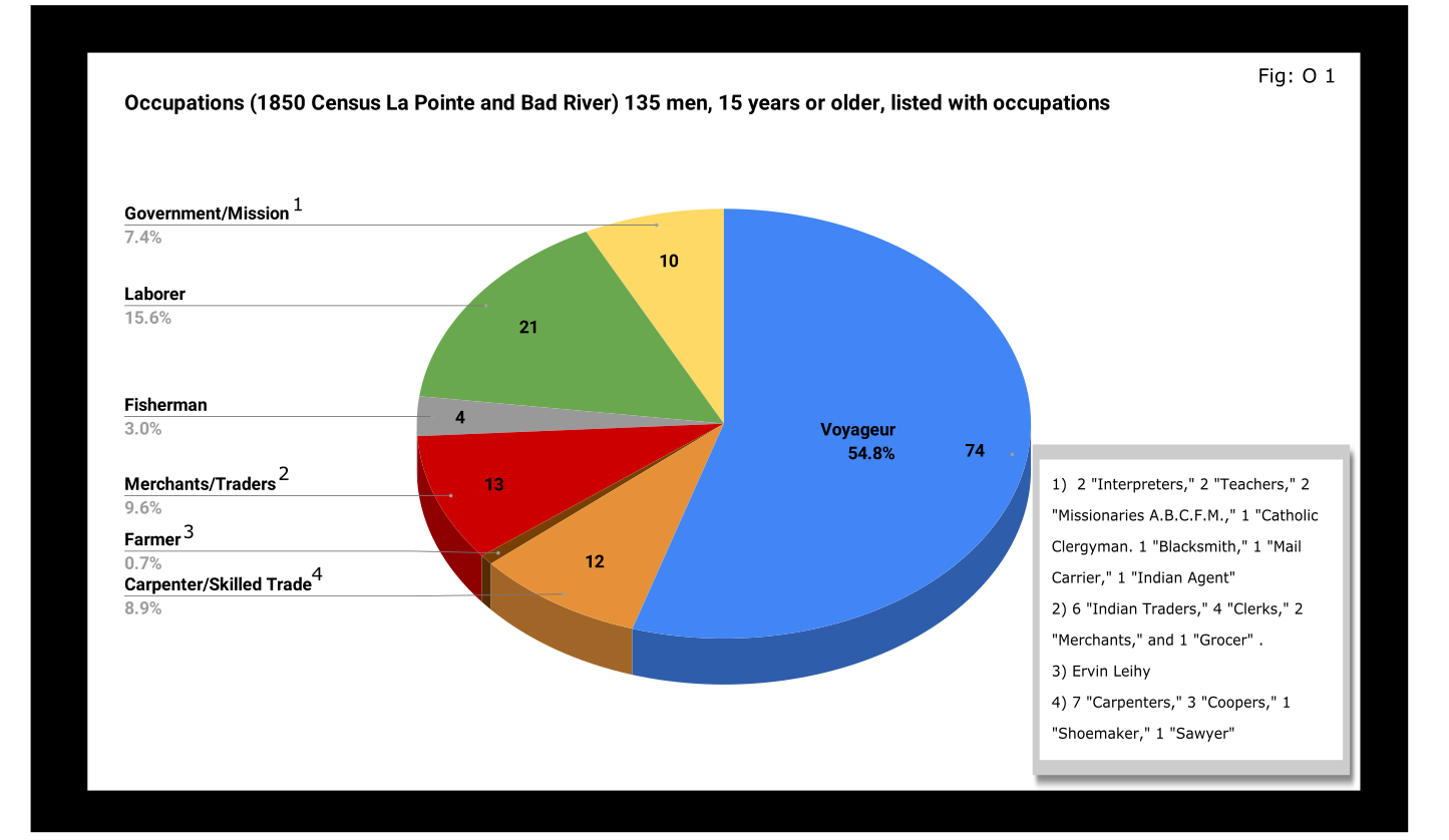
A full 55% of enumerated men fifteen and older still identified themselves as voyageurs in 1850. This included teenagers as well as senior citizens. All were from Metis households, though aside from farmer, all of the other occupation categories in Figure O 1 included Metis people.

A look at household sizes did not show voyageurs having to support significantly larger or smaller families when compared to the other occupation categories.
The other piece of economic data collected was value of real estate. Here we see some interesting themes:

If real estate is a good proxy for wealth in a farming community, it is an imperfect one in the Chequamegon area of 1850. If a voyageur had no home but the river and portage, then we might not expect him to put his coin into land and buildings. A teacher or Indian agent might draw a consistent salary but then live in supplied housing before moving on. With that caveat, let’s dig into the data.
Excluding the single farmer, men in the merchant/trader group controlled the most wealth in real estate, with Julius Austrian controlling as much as the other merchants combined. Behind them were carpenters and men with specific trades like cooper or shoemaker. Those who reported their occupation generally as “laborer” were not far behind the tradesmen. I suspect their real estate holdings may be larger and less varied than expected because of the number of sons and close relatives of Michel Cadotte Sr. who identified themselves as laborers. Government and mission employees held relatively little real estate, but the institutions they represented certainly weren’t lacking in land or power. Voyageurs come in seventh, just behind widows and ahead of fishermen of which there were only four in each category.
It is interesting, though, that the second and third richest men (by real estate) were both voyageurs, and voyageur shows a much wider range of households than some of the other categories: laborers in particular. With the number of teenagers calling themselves voyageurs, I suspect that the job still had more social prestige attached to it, in 1850, than say farmer or carpenter.
With hindsight we know that after 1854, voyageurs would be encouraged to take up farming and commercial fishing. It is striking, however, how small these industries were in 1850. Despite the American Fur Company’s efforts to push its Metis employees into commercial fishing in the 1830s, and knowing how many of the family names in Figure O 3 are associated with the industry, commercial fishing seemed neither popular nor lucrative in 1850. I do suspect, however, that the line between commercial and subsistence fishing was less defined in those days and that fishing in general was seen as falling back on the Indian gathering lifestyle. It wouldn’t be surprised if all these families were fishing alongside their Ojibwe relatives but didn’t really see fishing (or sugaring, etc.) as an occupation in the American sense.
Finally, it could not have escaped the voyageurs notice that while they were struggling, their former employers and their employers educated sons were doing pretty well. They also would have noticed that it was less and less from furs. Lump annuity payments for Ojibwe land sales brought large amounts of cash into the economy one day a year. It must have felt like piranhas with blood in the water. Alongside their full-blood cousins, Metis Ojibwe received these payments after 1847, but they had more of a history with money and capitalism. Whether to identify with the piranha or the prey would have depended on all sorts of decisions, opportunities and circumstances.
Education and Literacy
The census also collected data on education and literacy, asking whether children had attended school within the year, and whether adults over twenty could read and write. The history of white education efforts in this area are fairly well documented. The local schools in 1850 were run by the American Board of Commissioners of Foreign Missions (A.B.C.F.M.) at the La Pointe and Odanah missions, and an entire generation had come of age at La Pointe in the years since Rev. Sherman Hall first taught out of Lyman Warren’s storehouse in 1831. These Protestant ministers and teachers railed against the papists and heathens in their writings, but most of their students were Catholic or traditional Ojibwe in religion. Interestingly, much of the instruction was done in the Ojibwe language. Unfortunately, however, the census does not indicate the language an individual is literate in. I highly recommend The Ojibwe Journals of Edmund F. Ely, 1833-1849 if you are interested in these topics.
To start with, though, let’s look at how many people were going to school:

Thirty-nine students had gone to school in the previous year. There is a lot of sample-size noise in the data, but it seems like ages 7-11 (what we would call the upper-elementary years) were the prime years to attend school.
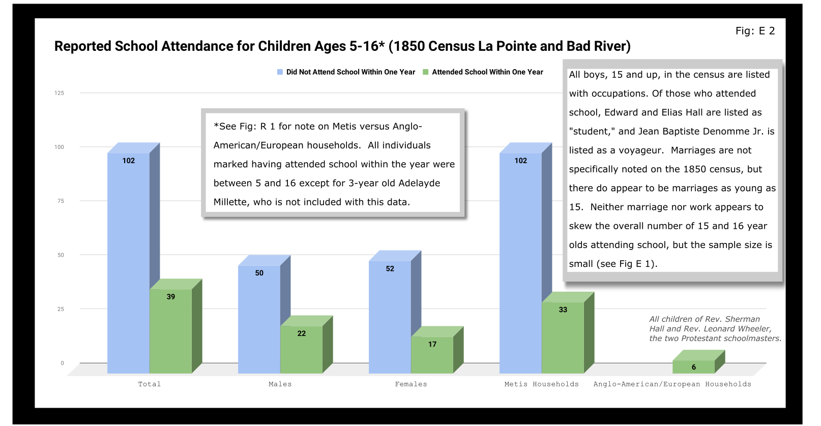
Overall, most children had not attended school within the year. Attendance rates were slightly higher for boys than for girls. White children, all from two missionary families, had a 100% attendance rate compared to 24% for the Metis and “Civilized Indian” children.
We should remember, however, that not attending school within the year is not the same as having never attended school. Twelve-year-old Eliza Morrin (later Morrison) is among the number that didn’t attend school, but she was educated enough to write her memoirs in English, which was her second language. They were published in 2002 as A Little History of My Forest Life, a fascinating account of Metis life in the decades following 1854.
Eliza’s parents were among the La Pointe adults who could read and write. Her aunt, uncle, and adult cousins in the neighboring Bosquet (Buskey) house were not. Overall, just over half of adults over 20 were illiterate without a significant gender imbalance. Splitting by birthplace, however, shows the literacy rate for Wisconsin-born (i.e. Metis and “Civilized Indian”) was only 30%, down from the overall male literacy rate of 48%. For Wisconsin-born women, the drop is only three points, from 47% to 44%. This suggests Metis women were learning to read while their husbands and brothers (perhaps en voyage) were not.

And this is exactly what the data say when we split by occupation. The literacy rate for voyageurs was only 13%. This beats fisherman–all four were illiterate–but lagged far behind all other types of work.
If education was going to be a factor in the economic mobility of unemployed voyageurs, the trends weren’t looking good.
Odds and Ends
Two marriages were reported as occurring in the year previous to the census: Peter and Caroline Vanderventer and Pierre and Marguerite Robideaux (ak.a. Peter and Margaret Rabideaux). Though married, however, Caroline was not living with her husband, a 32-year old grocer from New York. She (along with their infant daughter) was still in the home of her parents Benjamin and Margaret Moreau (Morrow). The Vanderventers eventually built a home together and went on to have several more children. It appears their grandson George Vanderventer married Julia Rabideaux, the granddaughter of Peter and Margaret.
I say appears in the case of George and Julia, because Metis genealogy can be tricky. It requires lots of double and triple checking. Here’s what I came across when I once tried to find an unidentified voyageur known only as Baptiste:

Sometimes it feels like for every Souverain Denis or Argapit Archambeau, there are at least 15 Jean-Baptiste Cadottes, 12 Charles Bresettes, 10 Francois Belangers and 8 Joseph DeFoes. Those old Canadian names had a way of persisting through the generations. If you were a voyageur at La Pointe in 1850, there was nearly a 30% chance your name was Jean-Baptiste. To your friends you might be John-Baptist, Shabadis, John, JB, or Battisens, and you might be called something else entirely when the census taker came around.
The final column on Daniel Johnson’s census asked whether the enumerated person was “deaf and dumb, blind, insane, idiotic, pauper, or convict.” 20 year-old Isabella Tremble, living in the household of Charles Oakes, received the unfortunate designation of idiotic. 26-year-old Francois DeCouteau did not have a mark in that column, but had “Invalid” entered in for his occupation. It’s fair to say we’ve made some progress in the treatment of people with disabilities.
Final Thoughts
I am not usually a numbers person when it comes to history. I’ll always prefer a good narrative story, to charts, tables, and cold numbers. Sometimes, though, the numbers help tell the story. They can help us understand why when Louis Gurnoe was killed, no one was held accountable. At the very least, they can help show us that the society he lived in was under significant stress, that the once-prestigious occupation of his forefathers would no longer sustain a family, and that the new American power structure didn’t really understand or care who his people were.
Ultimately, the census is about America describes itself. From the very beginning, it’s never been entirely clear if in E. pluribus unum we should emphasize the pluribus or the unum. We struggled with that in 1850, and we still struggle today. To follow the Department of Commerce v. New York citizenship case, I recommend Scotusblog. For more census posts about this area in the 19th century, keep following Chequamegon History.
Sources, Data, and Further Reading
-
Paap, Howard D. Red Cliff, Wisconsin a History of an Ojibwe Community ; Volume 1 The Earliest Years: the Origin to 1854. North Star Press of St. Cloud, Inc., 1854.
-
Satz, Ronald N. Chippewa Treaty Rights: the Reserved Rights of Wisconsin’s Chippewa Indians in Historical Perspective. University of Wisconsin Press, 1997.
-
Original Census Act of May 23, 1850 (includes form and instructions for marshals). (PDF)
-
Compiled data spreadsheets (Google Drive Folder) I’ll make these a lot more user friendly in future census posts. By the time it occurred to me that I should include my tables in this post, most of them were already done in tally marks on scrap paper.
-
Finally, these are the original pages, scanned from microfilm by FamilySearch.com. I included the image for Fond du Lac (presumably those living on the Wisconsin side of the St. Louis River) even though I did not include it in any of the data above.
-

- Bad River
-
- Fond du Lac (not included in above data)


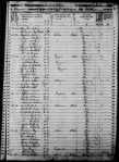

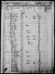
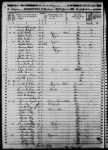


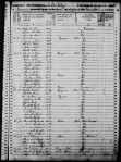
An Incident of Chegoimegon
November 26, 2016
By Amorin Mello
This is a reproduction of “An Incident of Chegoimegon – 1760” from Report and Collections of the State Historical Society of Wisconsin: For the years 1877, 1878 and 1879. Volume VIII., pages 224-226.
—
AN INCIDENT OF CHEGOIMEGON – 1760.*
—
We have been permitted to extract the following from the journal of a gentleman who has seen a large portion of the country to the north and west of this place, and to whose industry our readers have been often indebted for information relating to the portion of country over which he has passed, and to transactions among the numerous tribes, within the limits of this territory, which tend to elucidate their characteristics, and lay open the workings of their untaught minds:

Detail of Isle de la Ronde from Carte des lacs du Canada by Jacques-Nicolas Bellin; published in Charlevoix’s Histoire et Description Générale de Nouvelle France, Paris, 1744.
Monecauning (abbreviated for “Monegoinaic-cauning,” the Woodpecker Island, in Chippewa language) – which is sometimes called Montreal Island, Cadott’s Island, or Middle Island, and is one of “the Apostles” mentioned by Charlevoix. it is situated in Lake Superior, about ninety miles from Fond du Lac, at the extremity of La Pointe, or Point Chegoimegon.
On this island the French Government had a fort, long previous to its surrender to the English, in 1763. It was garrisoned by regular soldiers, and was the most northern post at which the French king had troops stationed. It was never re-occupied by the English, who removed everything valuable to the Sault de St. Marie, and demolished the works. It is said to have been strongly fortified, and the remains of the works may yet be seen.
In the autumn of 1760, all of the traders except one, who traded from this post, left it for their wintering grounds. He who remained had with him his wife, who was a lady from Montreal, his child – a small boy, and one servant. During the winter, the servant, probably for the purpose of plunder, killed the trader and his wife; and a few days after their death, murdered the child. He continued at the fort until the spring. When the traders came, they enquired for the gentleman and his family; and were told by the servant, that in the month of March, they left him to go to their sugar camp, beyond the bay, since which time he had neither seen nor heard them. The Indians, who were somewhat implicated by this statement, were not well satisfied with it, and determined to examine into its truth. They went out and searched for the family’s tracks; but found none, and their suspicions of the murderer increased. They remained perfectly silent on the subject; and when the snow had melted away, and the frost left the ground, they took sharp stakes and examined around the fort by sticking them into the ground, until they found three soft spots a short distance from each other, and digging down they discovered the bodies.
The servant was immediately seized and sent off in an Indian canoe, for Montreal, for trial. When passing the Longue Saut, in the river St. Lawrence, the Indians who had him in charge, were told of the advances of the English upon Montreal, and that they could not in safety proceed to that place. They at once became a war party, – their prisoner was released, and he joined and fought with them. Having no success, and becoming tired of the war, they sought their own land – taking the murderer with them as one of their war party.
They had nearly reached the Saut de St. Marie, when they held a dance. During the dance, as is usual, each one “struck the post,” and told, in his manner, of his exploits. The murderer, in his turn, danced up to the post, and boasted that he had killed the trader and his family – relating all the circumstances attending the murder. The chief heard him in silence, saving the usual grunt, responsive to the speaker. The evening passed away, and nothing farther occurred.
The next day the chief called his young men aside, and said to them: “Did you not hear this man’s speech last night? He now says that he did the murder with which we charged him. He ought not to have boasted of it. We boast of having killed our enemies – never our friends. Now he is going back to the place where committed the act, and where we live – perhaps he will again murder. He is a bad man – neither we nor our friends are safe. If you are of my mind, we will strike this man on the head.” They all declared themselves of his opinion, and determined that justice should be rendered him speedily and effectually.
They continued encamped, and made a feast, to which the murderer was invited to partake. They filled his dish with an extravagant quantity, and when he commenced his meal, the chief informed him, in a few words, of the decree in council, and that as soon as he had finished his meal, either by eating the whole his dish contained, or as much as he could, the execution was to take place. The murderer, now becoming sensible of his perilous situation, from the appearance of things around him, availed himself of the terms of the sentence he had just heard pronounced, and did ample justice to the viands. He continued, much to the discomfiture of the “phiz” of justice (personified by the chief, who all the while sat smoking through his nose), eating and drinking until he had sat as long as a modern alderman at a corporation dinner. But it was of no avail – when he ceased eating he ceased breathing.
The chief cut up the body of the murderer, and boiled it for another feast – but his young men would touch none of it – they said, “he was not worthy to be eaten – he was worse than a bad dog. We will not taste him, for if we do, we shall be worse than dogs ourselves.”
Mr. Morrison, who gave me the above relation, told me he had it from a very old Indian, who was present at the death of the murderer.
* – This paper was originally published in the Detroit Gazette, Aug. 30, 1822. Hon. C. C. Throwbridge of Detroit, a resident of that place for sixty years, states that Mr. Schoolcraft, without doubt, contributed this sketch to the Gazette; that Mr. Schoolcraft, at the time of its publication, was residing at the Saut St. Marie: and Mr. Morrison, who was one of Mr. Astor’s most trusted agents at “L’Anse Qui-wy-we-nong,” came down to Mackinaw every summer, and thus gave Mr. Schoolcraft the information.
L. C. D.
The Story of Chequamegon Bay
March 1, 2016
By Amorin Mello
This is a reproduction of Reuben Gold Thwaites’ 1895 “The Story of Chequamegon Bay” to demonstrate how our local history has been institutionalized and portrayed since the end of the 19th century. Thwaites’ professional legacy as a journalist is embedded in many institutions, including the following:
- American Library Association
- American Antiquarian Society
- University of Wisconsin
- Wisconsin State Journal
- Wisconsin Historical Society
- Mississippi Valley Historical Association
According to Wikipedia:
Thwaites was well-known for not being a mere academic, but rather as a historian who attempted to understand history by experiencing those aspects that he could, and bringing those experiences to life. In 1888 he took canoe trips on the Wisconsin, Fox and Rock rivers. In 1892 he took a bicycle trip across England. In 1903 he took a trip down the Ohio River in a rowboat.
Thwaites’ approach and work has been questioned, to some degree by his contemporaries but more so in modern times. His summaries include phraseology such as “[Europeans] left the most luxurious country in Europe to seek shelter in the foul and unwelcome huts of one of the most wretched races of man.” When editing the Jesuit Relations, he included background information that is generally credible and thorough with respect to events and Europe, but is far less thorough in regard to the disruptions from disease and other sources that the indigenous people themselves were facing. In other words, the criticism is that the original works were insensitive, and Thwaites failed to fully account for the prejudicial and inaccurate reporting in the Relations. However, Thwaites is also recognized as being the pioneer in an approach to using the Relations that is continuing to be enriched by modern scholarship, and so in a sense he started a process by which his very work could be corrected and improved as historians learn more about the periods in question.
The purpose of reproducing this story is to serve as an introduction to Chequamegon Bay history, and as a reference point for modern scholarship and primary research about Chequamegon Bay before 1860.
The Story about Chequamegon Bay was originally published in Collections of the State Historical Society of Wisconsin: Volume XIII, by Reuben Gold Thwaites, 1895, pages 397-425.
The Story Of Chequamegon Bay.
by the Editor.

Reuben Gold Thwaites
~ Wisconsin Historical Society
WE commonly think of Wisconsin as a young State. In a certain sense she is. There are men now living, two or three of whom I meet almost daily, who were blazing paths through the Wisconsin wilderness, only sixty years ago: men who cleared the forests and broke the prairies; who founded frontier communities which have developed into cities; who upon this far away border sowed the seeds of industries which to-day support tens of thousands of their fellows; who threw up their hats when the Territory was erected; and who sat in the convention which gave to the new State a constitution. The Wisconsin of to-day, the Wisconsin which we know, is indeed young; for the lively octogenarians who were in at the birth will not admit that they are now old. But there was an earlier, a less prosaic, a far more romantic Wisconsin,—the French Wisconsin; and it had flourished in its own fashion for full two centuries before the coming of the Anglo-Saxon, who, brusquely crowding the Creole to the wall, made of his old home an American Commonwealth.
In 1634, when the child born upon the Mayflower was but in her fourteenth year, Jean Nicolet, sent out by the enterprising Champlain as far as Wisconsin,— a thousand miles of canoe journey west from Quebec,— made trading contracts, such as they were, with a half-score of squalid tribes huddled in widely-separated villages throughout the broad wilderness lying between Lakes Superior and Michigan. It was a daring, laborious expedition, as notable in its day as Livingstone’s earliest exploits in Darkest Africa ; and although its results were slow of development,—for in the seventeenth century man was still cautiously deliberate,— this initial visit of the forest ambassador of New France to the country of the Upper Lakes broke the path for a train of events which were of mighty significance in American history.1

“Jean Nicolet, landing at the Bay of Green Bay in 1634. Painted by Franz Edward Rohrbeck (1852-1919) in 1910 into the mural in the rotunda of the Brown County Courthouse, Green Bay, Wisconsin. It shows Nicolet wearing a Chinese damask tunic strewn with flowers and birds, and discharging two pistols into the air.”
~ Wikipedia.org
Let us examine the topography of Wisconsin. The State is situated at the head of the chain of Great Lakes. It is touched on the east by Lake Michigan, on the north by Lake Superior, on the west by the Mississippi, and is drained by interlacing rivers which so closely approach each other that the canoe voyager can with case pass from one great water system to the other; he can enter the continent at the Gulf of St. Lawrence, and by means of numerous narrow portages in Wisconsin emerge into the south-flowing Mississippi, eventually returning to the Atlantic through the Gulf of Mexico. From Lake Michigan, the Fox-Wisconsin river system was the most popular highway to the great river; into Lake Superior, there flow numerous turbulent streams from whose sources lead short portage trails over to the headwaters .of feeders of the Mississippi. From the western shore of Lake Superior, Pigeon River invites to exploration of the Winnipeg country, whence the canoeist can by a half-hundred easy routes reach the distant regions of Athabasca and the Polar Sea. In their early voyages to the head of lake navigation, it was in the course of nature that the French should soon discover Wisconsin; and having discovered it, learn that it was the key-point of the Northwest — the gateway to the entire continental interior. Thus, through Wisconsin’s remarkable system of interlacing waterways, to which Nicolet led the way, New France largely prosecuted her far-reaching forest trade and her missionary explorations, securing a nominal control of the basin of the Mississippi at a time when Anglo-Saxons had gained little more of the Atlantic slope than could be seen from the mast-head of a caravel. Thus the geographical character of Wisconsin became, early in the history of New France, an important factor. The trading posts and Jesuit missions on Chequamegon Bay2 of Lake Superior, and on Green Bay of Lake Michigan, soon played a prominent part in American exploration. The career of Green Bay is familiar to us all.3 I have thought it well hastily to summarize, in the brief space allowed me, the equally instructive story of Chequamegon Bay.

“Outline Map showing the position of the ancient mine-pits of Point Keweenaw, Michigan”
~ Ancient Mining on the Shores of Lake Superior, by Charles Whittlesey
The sandstone cliffs of Lake Superior were, many geologists think, among the first Laurentian islands to arise from the ancient ocean; if this be so, then the rim of our greatest inland sea is one of the oldest spots on earth. In its numerous mines of copper, prehistoric man long delved and wrought with rude hammers and chisels of stone, fashioning those curious copper implements which are carefully treasured in American museums of archaeology;4 and upon its rugged shores the Caucasian early planted his stake, when between him and New England tidewater all was savagery.
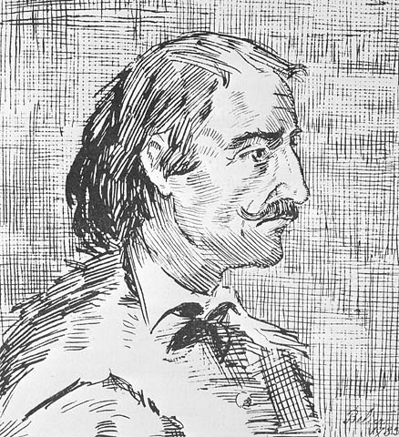
Pierre d’Esprit Sieur Radisson
~ Dictionary of Canadian Biography
After the coming to Wisconsin of Nicolet, a long period followed, in which the energies of New France were devoted to fighting back the Iroquois, who swarmed before the very gates of Quebec and Montreal. Exploration was for the time impossible. A quarter of a century passes away before we have evidence of another white man upon Wisconsin soil. In the spring of 1659, the Indians of the valley of the Fox were visited by two French fur-traders from the Lower St. Lawrence – Pierre d’Esprit, Sieur Radisson, and his sister’s husband, Medard Chouart, Sieur de Groseilliers. In all American history there are no characters more picturesque than these two adventurous Creoles, who, in their fond desire to “travell and see countries,” and “to be known as the remotest people,” roamed at will over the broad region between St. Jame’s seaway and the Wisconsin River, having many curious experiences with wild beasts and wilder men. They made several important geographical discoveries, – among them, probably, the discovery of the Mississippi River in 1659, fourteen years before the visit of Joliet and Marquette; and from a trading settlement proposed by them to the English, when their fellow-countrymen no longer gave them employment, developed the great establishment of the Hudson’s Bay Company. The unconsciously-amusing narrative which Radisson afterwards wrote, for the editication of King Charles II, of England, is one of the most interesting known to American antiquaries.5

“Arrival of Radisson in an Indian camp, 1660”
by Charles William Jefferys
~ Wikimedia.org
Two years after Radisson and Groseilliers were upon the Fox River, and made their notable trip to the Mississippi, they were again in the Northwest (autumn of 1661), and this time upon Lake Superior, which they had approached by carrying around the Sault Ste. Marie. Skirting the southern shore of the lake, past the now famous Pictured Rocks, they carried across Keweenaw Point, visited a band of Christino Indians6 not far from the mouth of Montreal River, now the far western boundary between Upper Michigan and Wisconsin, and, portaging across the base of the Chequamegon Island of to-day, – then united to the mainland,- entered beautiful Chequamegon Bay. Just where they made their camp, it is impossible from Radisson’s confused narrative to say; but that it was upon the mainland no Wisconsin antiquary now doubts, and we have reason to believe that it was upon the southwest shore, between the modern towns of Ashland and Washburn.7

“Close-up of the Radisson and Groseilliers house historic site marker, commemorating the first house built in Wisconsin by white men. The house was believed to have stood in the vicinity of Ashland at the mouth of Fish Creek where it empties into Chequamegon Bay.”
~ Wisconsin Historical Society
Our chronicler writes, with a particularity of detail suggestive of De Foe:
“We went about to make a fort of stakes, w’ was in this manner. Suppose that the watter-side had ben in one end; att the same end there should be murtherers, and att need we made a bastion in a triangle to defend us from assault. The doore was neare the watter side, our fire was in the midle, and our bed on the right hand, covered. There were boughs of trees all about our fort layed acrosse, one uppon an other. Besides those boughs, we had a long cord tyed w’ some small bells, w’ weare sentereys. Finally, we made an ende of that fort in 2 dayes’ time.”
“Front view of the Radisson cabin, the first house built by a white man in Wisconsin. It was built between 1650 and 1660 on Chequamegon Bay, in the vicinity of Ashland. This drawing is not necessarily historically accurate.”
~ Wisconsin Historical Society
Modernize this statement, and in imagination we can see this first dwelling erected by man on the shores of Lake Superior; a small log hut, built possibly on the extremity of a small rocky promontory; the door opens to the water front, while the land side, to the rear of the hut, is defended by a salient of palisades stretching from bank to bank of the narrow promontory; all about the rude structure is a wall of pine boughs piled one upon the other, with a long cord intertwined, and on this cord are strung numbers of the little hawk-bells then largely used in the Indian trade for purposes of gift and barter. It was expected that in case of a night attack from savages, who might be willing to kill them for the sake of their stores, the enemy would stir the boughs and unwittingly ring the bells, thus arousing the little garrison. These ingenious defenses were not put to the test, although no doubt they had a good moral effect; in keeping the thieving Hurons at a respectful distance.
Winter was just setting in. The waters of the noble bay were taking on that black and sullen aspect peculiar to the season. The beautiful islands, later named for the Twelve Apostles,8 looked gloomy indeed in their dark evergreen mantles. From the precipitous edges of the red-sandstone cliffs, which girt about this estuary of our greatest inland sea, the dense pine forests stretched westward and southward for hundreds of miles. Here and there in the primeval depths was a cluster of starveling Algonkins, still trembling from fear of a return of the Iroquois, who had chased them from Canada into this land of swamps and tangled woods, where their safety lay in hiding. At wide intervals, uncertain trails led from village to village, and in places the rivers were convenient highways; these narrow paths, however, beset with danger in a thousand shapes, but emphasized the unspeakable terrors of the wilderness.
Père René Ménard
“The Search for Wisconsin’s First Priest”
~ Wisconsin Historical Society
Radisson and Groseilliers, true coureurs de bois, were not daunted by the dangers which daily beset them. After caching their goods, they passed the winter of 1661-62 with their Huron neighbors, upon a prolonged hunt, far into the Mille Lacs region of Minnesota. The season was phenomenally severe, and the Indians could not find game enough to sustain life. A famine ensued in the camp, the tragical details of which are painted by our friend Radisson with Hogarthian minuteness. In the spring of 1662, the traders were back again at Chequamegon, and built another fortified shelter, this time possibly on the sand-spit of Shagawaumikong,9 from which base they once more wandered in search of adventures and peltries, going as far northwest as Lake Assiniboine, and later in the season returning to their home on the Lower St. Lawrence.
When Radisson’s party went to Lake Superior, in the autumn of 1661, they were accompanied as far as Keweenaw Bay by a Jesuit priest. Father Pierre Ménard, who established there a mission among the Ottawas. The following June, disheartened in his attempt to convert these obdurate tribesmen, Ménard set out for the Huron villages on the upper waters of the Black and Chippewa, but perished on the way.10
It was not until August of 1665, three years later, that Father Claude Allouez, another Jesuit, was sent to reopen the abandoned Ottawa mission on Lake Superior. He chose his site on the southwestern shore of Chequamegon Bay, possibly the same spot on which Radisson’s hut had been built, four years previous, and piously called his mission and the locality La Pointe du Saint Esprit, which in time was shortened to La Pointe.11

Detail of La Pointe du Saint Esprit
from Claude Allouez map’s of New France, 1669.
~ Research Laboratories of Archaeology

Portrayal of Claude Allouez
~ National Park Service
At the time of Radisson’s visit, the shores of Chequamegon Bay were uninhabited save by a few half-starved Hurons ; but soon thereafter it became the centre of a considerable Indian population, residents of several tribes having been drawn thither, first, by the fisheries, second, by a fancied security in so isolated a region against the Iroquois of the East and the wild Sioux of the West. When Allouez arrived in this polyglot village, October 1, he found there Chippewas, Pottawattómies, Kickapoos, Sauks, and Foxes, all of them Wisconsin tribes; besides these were Hurons, Ottawas, Miamis, and Illinois,— victims of Iroquois hate who had fled in droves before the westward advances of their merciless tormentors.

Jacques Marquette
aka James (Jim) or Père Marquette
~ Wikipedia
Despite his large congregations, Allouez made little headway among these people, being consoled for his hardships and ill-treatment by the devotion of a mere handful of followers. For four years did he labor alone in the Wisconsin wilderness, hoping against hope, varying the monotony of his dreary task by occasional canoe voyages to Quebec, to report progress to his father superior. Father James Marquette, a more youthful zealot, was at last sent to relieve him, and in September, 1669, arrived at La Pointe from Sault Ste. Marie, after spending a full month upon, the journey,—so hampered was he, at that early season, by snow and ice. Allouez, thus relieved from a work that had doubtless palled upon him, proceeded upon invitation of the Pottawattomies to Green Bay, where he arrived early in December, and founded the second Jesuit mission in Wisconsin, St. Francis Xavier, on the site of the modern town of Depere.12
Marquette had succeeded to an uncomfortable berth. Despite his strenuous efforts as a peacemaker, his dusky parishioners soon unwisely quarreled with their western neighbors, the Sioux,13 with the result that the La Pointe bands, and Marquette with them, were driven like leaves before an autumn blast eastward along the southern shore of the great lake: the Ottawas taking up their home in the Manitoulin Islands of Lake Huron, the Hurons accompanying Marquette to the Straits of Mackinaw, where he established the mission of St. Ignace.
With La Pointe mission abandoned, and Lake Superior closed to French enterprise by the “raging Sioux,” the mission at Depere now became the centre of Jesuit operations in Wisconsin, and it was a hundred and sixty-four years later (1835), before mass was again said upon the forest-fringed shores of Chequamegon Bay.
“‘Daniel Greysolon Sieur Dulhut at the Head of the Lakes – 1679.’ Painted by artist Francis Lee Jaques, c.1922.”
~ Minnesota Historical Society
Although the missionary had deserted La Pointe, the fur trader soon came to be much in evidence there. The spirit of Radisson and Groseilliers long permeated this out-of-the-way corner of the Northwest. We find (1673), three years after Marquette’s expulsion. La Salle’s trading agent, Sieur Raudin, cajoling the now relentent Sioux at the western end of Lake Superior. In the summer of 1679, that dashing coureur de bois, Daniel Grayson du l’ Hut,14 ascended the St. Louis River, which divides Wisconsin and Minnesota, and penetrated with his lively crew of voyageurs to the Sandy Lake country, being probably the first white trader upon the head-waters of the Mississippi. The succeeding winter, he spent in profitable commerce with the Assiniboines, Crees, and other northern tribes in the neighborhood of Grand Portage,15 on the boundary between Minnesota and Canada. In June, 1680, probably unaware of the easier portage by way of the Mille Lacs and Rum River, Du I’ Hut set out at the head of a small company of employees to reach the Mississippi by a new route. Entering the narrow and turbulent Bois Brulé,16 half-way along the southern shore of Lake Superior, between Red Cliff and St. Louis River, he with difficulty made his way over the fallen trees and beaver dams which then choked its course. From its head waters there is a mile-long portage to the upper St. Croix; this traversed. Du l’ Hut was upon a romantic stream which swiftly carried him, through foaming rapids and deep, cool lakes, down into the Father of Waters. Here it was that he heard of Father Louis Hennepin’s captivity among the Sioux, and with much address and some courage rescued that doughty adventurer, and carried him by way of the Fox-Wisconsin route in safety to Mackinaw.
…
“In 1693, Le Sueur founded a trading post on the site of present-day La Pointe on Madeline Island, the largest of Chequamegon Bay’s Apostle Islands. After hearing reports of what he believed were valuable deposits of copper ore south of Lake Superior, he traveled to France in 1697, where the French government granted him permission to mine these resources.”
~ Encyclopedia of Exploration, vol. 1, 2004.
An adventurous forest trader, named Le Sueur, was the next man to imprint his name on the page of Lake Superior history. The Fox Indians, who controlled the valleys of the Fox and Wisconsin Rivers, had for various reasons become so hostile to the French that those divergent streams were no longer safe as a gateway from the Great Lakes to the Great River. The tendency of the prolonged Fox War was to force fur trade travel to the portages of Chicago and St. Joseph’s on the south, and those of Lake Superior on the north.17 It was with a view to keeping open one of Du l’ Hut’s old routes, – the Bois Brulé and St. Croix Rivers,- that Le Sueur was despatched by the authorities of New France in 1693. He built a stockaded fort on Madelaine island, convenient for guarding the northern approach,18 and another on an island in the Mississippi, below the mouth of the St. Croix, and near the present town of Red Wing, Minnesota. The post in the Mississippi soon became “the centre of commerce for the Western parts”; and the station in Chequamegon Bay also soon rose to importance, for the Chippewas, who had drifted far inland into Wisconsin and Minnesota with the growing scarcity of game,- the natural result of the indiscriminate slaughter which the fur trade encouraged, – were induced by the new trading facilities to return to their old bay shore haunts, massing themselves in an important village on the southwestern shore.
This incident strikingly illustrates the important part which the trader early came to play in Indian life. At first an agriculturalist in a small way, and a hunter and fisher only so far as the daily necessities of food and clothing required, the Indian was induced by the white man to kill animals for their furs, – luxuries ever in great demand in the marts of civilization. The savage wholly devoted himself to the chase, and it became necessary for the white man to supply him with clothing, tools, weapons, and ornaments of European manufacture; the currency as well as the necessities of the wilderness.19 These articles the savage had heretofore laboriously fashioned for himself at great expenditure of time; no longer was he content with native manufactures, and indeed he quickly lost his old-time facility for making them. It was not long before he was almost wholly dependent on the white trader for the commonest conveniences of life; no longer being tied to his fields, he became more and more a nomad, roving restlessly to and fro in search of fur-bearing game, and quickly populating or depopulating a district according to the conditions of trade. Without his trader, he quickly sank into misery and despair; with the advent of the trader, a certain sort of prosperity once more reigned in the tepee of the red man. In the story of Chequamegon Bay, the heroes are the fur trader and the missionary; and of these the fur trader is the greater, for without his presence on this scene there would have been no Indians to convert.
~ State of Wisconsin Blue Book, 1925, page 66.
Although Le Sueur was not many years in command upon Chequamegon Bay,20 we catch frequent glimpses thereafter of stockaded fur trade stations here, – French, English, and American, in turn, – the most of them doubtless being on Madelaine Island, which was easily defensible from the mainland.21 We know that in 1717 there was a French trader at La Pointe – the popular name for the entire bay district—for he was asked by Lt. Robertel de la Noüe, who was then at Kaministiquoya, to forward a letter to a certain Sioux chief. In September, 1718, Captain Paul Legardeur St. Pierre, whose mother was a daughter of Jean Nicolet, Wisconsin’s first explorer, was sent to command at Chequamegon, assisted by Ensign Linctot, the authorities of the lower country having been informed that the Chippewa chief there was, with his fellow-chief at Keweenaw, going to war with the Foxes. St. Pierre was at Chequamegon for at least a year, and was succeeded by Linctot, who effected an important peace between the Chippewas and Sioux.22
The Indians at La Pointe told the French of an island of copper guarded by spirits; La Ronde, when he heard of the mineral, requested permission from the French Government to combine his duties at the fort with mining. he was not given permission to operate the mines until 1733, and in 1740 his mining activities were halted by an outbreak between the Sioux and the Chippewa. Nonetheless, La Ronde is known as the first practical miner on Lake Superior, and the man who opened this region for settlement by white men.”
~ The WPA Guide to Wisconsin, by Federal Writers’ Project, 2013, page 348.
~ Dictionary of Canadian Biography
Whether a garrisoned fort was maintained at Chequamegon Bay, from St. Pierre’s time to the close of the French domination, it is impossible to say; but it seems probable; for the geographical position was one of great importance in the development of the fur trade, and the few records we have mention the fort as one of long standing.23 In 1730, it is recorded, that a nugget of copper was brought to the post by an Indian, and search was at once made for a mine; but October 18, 1731, the authorities of New France wrote to the home office in Paris that, owing to the superstitions of the Indians, which led them to conceal mineral wealth from the whites, no copper mine had thus far been found in the neighborhood of Chequamegon Bay. The commandant of Chequamegon at this time was Sieur La Ronde Denis, known to history as La Ronde,— like his predecessors, for the most part, a considerable trader in these far Western parts, and necessarily a man of enterprise and vigor. La Ronde was for many years the chief trader in the Lake Superior country, his son and partner being Denis de La Ronde. They built for their trade a boat of 40 tons, which was without doubt “the first vessel on the great lake, with sails larger than an Indian blanket.” 24 On account of the great outlay they had incurred in this and other undertakings in the wilderness, the post of Chequamegon, with its trading monopoly, had been given to the elder La Ronde, according to a despatch of that day, “as a gratuity to defray expenses.” Other allusions to the La Rondes are not infrequent: in 1736,25 the son is ordered to investigate a report of a copper mine at Iron River, not far east of the Bois Brulé; in the spring of 1740, the father is at Mackinaw on his return to Chequamegon from a visit to the lower country, but being sick is obliged to return to Montreal;26 and in 1744, Bellin’s map gives the name “Isle de la Ronde” to what we now know as Madelaine, fair evidence that the French post of this period was on that island.

Detail of Isle de la Ronde from Carte des lacs du Canada by Jacques-Nicolas Bellin, 1744.
~ Wisconsin Historical Society
Pierre-Joseph was the son of Joseph Hertel de St.Francois & Catherine Philippe, born in Trois-Rivieres. He married Catherine-Madeleine Jarrot (daughter of Jean Bte.Jarrot, sieur de Vercheres & Madeleine Francoise d’Ailleboust de Manthet) in 1751. [Her father commanded the post at Green Bay in 1747].
Pierre-Joseph followed in his families tradition and was a captain on a raid of Albany in 1756 during the King George’s War. From 1756 to 1758 he was commander of the post of Lapointe (in today’s northern Wisconsin) and sailed for France after the loss of Canada to the British.”
~ [Unknown].
We hear nothing more of importance concerning Chequamegon until about 1756, when Hertel de Beaubassin, the last French commandant there, was summoned to Lower Canada with his Chippewa allies, to do battle against the English.27 For several years past, wandering English fur traders had been tampering with the Chippewas of Lake Superior, who in consequence frequently maltreated their old friends, the French;28 but now that the tribe were summoned for actual fighting in the lower country, with extravagant promises of presents, booty, and scalps, they with other Wisconsin Indians eagerly flocked under the French banner, and in painted swarms appeared on the banks of the St. Lawrence, with no better result than to embarrass the French commissariat and thus unwittingly aid the ambitious English.
New France was tottering to her fall. The little garrison on Madelaine Island had been withdrawn from the frontier, with many another like it, to help in the defense of the lower country ; and the Upper Lakes, no longer policed by the fur trade monopoly, were free plunder for unlicensed traders, or coureurs des bois. Doubtless such were the party who encamped upon the island during the autumn of 1760. By the time winter had set in upon them, all had left for their wintering grounds in the forests of the far West and Northwest, save a clerk named Joseph, who remained in charge of the stores and the local traffic. With him were his little family,—his wife, who was from Montreal, his child, a small boy, and a man-servant, or voyageur. Traditions differ as to the cause of the servant’s action,— some have it, a desire for wholesale plunder; others, the being detected in a series of petty thefts, which Joseph threatened to report; others, an unholy and unrequited passion for Joseph’s wife. However that may be, the servant murdered first the clerk, and then the wife; and in a few days, stung by the piteous cries of the child, the lad himself. When the spring came, and the traders returned to Chequamegon, they inquired for Joseph and his family, but the servant’s reply was unsatisfactory and he finally confessed to his horrid deed. The story goes, that in horror the traders dismantled the old French fort as a thing accursed, sunk the cannon in a neighboring pool, and so destroyed the palisade that to-day naught remains save grassy mounds. Carrying their prisoner with them on their return voyage to Montreal, he is said to have escaped to the Hurons, among whom he boasted of his deed, only to be killed as too cruel a companion even for savages.29

Detail of “The 12 Apostles” from Captain Jonathan Carver’s journal of his travels with maps and drawings, 1769. ~ Boston Public Library

Alexander Henry , The Elder.
~ Wikipedia.com
New France having now fallen, an English trader, Alexander Henry, spent the winter of 1765-66 upon the mainland, opposite the island.30 Henry had obtained from the English commandant at Mackinaw the exclusive trade of Lake Superior, and at Sault Ste. Marie took into partnership with him Jean Baptiste Cadotte,31 a thrifty Frenchman, who for many years thereafter was one of the most prominent characters on the Upper Lakes. Henry and Cadotte spent several winters together on Lake Superior, but only one upon the shores of Chequamegon, which Henry styles “the metropolis of the Chippeways.”32

John Johnston
~ Homestead.org
The next dweller at Chequamegon Bay, of whom, we have record, was John Johnston, a Scotch-Irish fur trader of some education. Johnston established himself on Madelaine Island, not far from the site of the old French fort; some four miles across the water, on the mainland to the west, near where is now the white town of Bayfield, was a Chippewa village with whose inhabitants he engaged in traffic. Waubojeeg (White Fisher), a forest celebrity in his day, was the village chief at this time, and possessed of a comely daughter whom Johnston soon sought and obtained in marriage. Taking his bride to his island home, Johnston appears to have lived there for a year or two in friendly commerce with the natives, at last retiring to his old station at Sault Ste. Marie.33
Mention has been made of Jean Baptiste Cadotte, who was a partner of Alexander Henry in the latter’s Lake Superior trade, soon after the middle of the century. Cadotte, whose wife was a Chippewa, after his venture with Henry had returned to Sault Ste. Marie, from which point he conducted an extensive trade through the Northwest. Burdened with advancing years, he retired from the traffic in 1796, and divided the business between his two sons, Jean Baptiste and Michel.

Michel Cadotte
~ Findagrave.com
About the opening of the present century,34 Michel took up his abode on Madelaine Island, and from that time to the present there has been a continuous settlement upon it. He had been educated at Montreal, and marrying Equaysayway, the daughter of White Crane, the village chief of La Pointe,35 at once became a person of much importance in the Lake Superior country. Upon the old trading site at the southwestern corner of the island, by this time commonly called La Pointe,— borrowing the name, as we have seen, from the original La Pointe, on the mainland, and it in turn from Point Chequamegon,—Cadotte for over a quarter of a century lived at his ease; here he cultivated a “comfortable little farm,” commanded a fluctuating, but often far-reaching fur trade, first as agent of the Northwest Company and later of Astor’s American Fur Company, and reared a considerable family, the sons of which were, as he had been, educated at Montreal, and became the heads of families of Creole traders, interpreters, and voyageurs whom antiquarians now eagerly seek when engaged in bringing to light the French and Indian traditions of Lake Superior.36
La Pointe Beaver Money
Northern Outfit, American Fur Company
~ Wisconsin Academy of Science, Arts, & Letters, volume 54, page 159.
In the year 1818 there came to the Lake Superior country two sturdy, fairly-educated37 young men, natives of the Berkshire hills of Massachusetts,—Lyman Marcus Warren, and his younger brother, Truman Abraham. They were of the purest New England stock, being lineally descended from Richard Warren, one of the “Mayflower” company. Engaging in the fur trade, the brothers soon became popular with the Chippewas, and in 1821 still further entrenched themselves in the affections of the tribesmen by marrying the two half-breed daughters of old Michel Cadotte,—Lyman taking unto himself Mary, while Charlotte became the wife of Truman. At first the Warrens worked in opposition to the American Fur Company, but John Jacob Astor’s lieutenants were shrewd men and understood the art of overcoming commercial rivals. Lyman was made by them a partner in the lake traffic, and in 1824 established himself at-La Pointe as the company’s agent for the Lac Flambeau, Lac Courte Oreille, and St. Croix departments, an arrangement which continued for some fourteen years. The year previous, the brothers had bought out the interests of their father-in-law, who now, much reduced in means, retired to private life after forty years’ prosecution of the forest trade.38

American Fur Company “Map of La Pointe”
by Lyman Marcus Warren, 1834.
~ Wisconsin Historical Society
The brothers Warren were the last of the great La Pointe fur traders.39 Truman passed away early in his career, having expired in 1825, while upon a voyage between Mackinaw and Detroit. Lyman lived at La Pointe until 1838, when his connection with the American Fur Company was dissolved, and then became United States sub-agent to the Chippewa reservation on Chippewa River, where he died on the tenth of October, 1847, aged fifty-three years.40

Iu Otoshki-Kikindiuin Au Tebeniminvng Gaie Bemajiinung Jesus Christ, Ima Ojibue Inueuining Giizhitong:
The New Testament of Our Lord and Saviour Jesus Christ
by Sherman Hall and Henry Blatchford, 1856.
~ Archive.org
Lyman Marcus Warren was a Presbyterian, and, although possessed of a Catholic wife, was the first to invite Protestant missionaries to Lake. Superior. Not since the days of Allouez had there been an ordained minister at La Pointe; Warren was solicitous for the spiritual welfare of his Chippewa friends, especially the young, who were being reared without religious instruction, and subject to the demoralizing influence of a rough element of white borderers. The Catholic Church was not just then ready to reenter the long-neglected field; his predilections, too, were for the Protestant faith. In 1830, while upon his annual summer trip to Mackinaw for supplies, be secured the cooperation of Frederick Ayer, of the Mackinaw mission, who returned with him in his batteau as lay preacher and school-teacher, and opened at La Pointe what was then the only mission upon the shores of the great lake. Thither came in Warren’s company, the latter part of August, the following year (1831), Rev. Sherman Hall and wife, who served as missionary and teacher, respectively, and Mrs. John Campbell, an interpreter.41
La Pointe was then upon the site of the old French trading post at the southwest corner of Madelaine Island; and there, on the first Sunday afternoon after his arrival, Mr. Hall preached “the first sermon ever delivered in this place by a regularly-ordained Christian minister.” The missionaries appear to have been kindly received by the Catholic Creoles, several of whom were now domiciled at La Pointe. The school was patronized by most of the families upon the island, red and white, who had children of proper age. By the first of September there was an average attendance of twenty-five. Instruction was given almost wholly in the English language, with regular Sunday-school exercises for the children, and frequent gospel meetings for the Indian and Creole adults.
We have seen that the first La Pointe village was at the southwestern extremity of the island. This was known as the “Old Fort” site, for here had been the original Chippewa village, and later the fur-trading posts of the French and English. Gradually, the old harbor became shallow, because of the shifting sand, and unfit for the new and larger vessels which came to be used in the fur trade.

The American Fur Company therefore built a “New Fort” a few miles farther north, still upon the west shore of the island, and to this place, the present village, the name La Pointe came to be transferred. Half-way between the “Old fort” and the “New fort,” Mr. Hall erected (probably in 1832) “a place for worship and teaching,” which came to be the centre of Protestant missionary work in Chequamegon Bay.

Leonard Hemenway Wheeler
~ Unnamed Wisconsin by John Nelson Davidson, 1895.
At that time, the Presbyterians and Congregationalists were, in the American Home Missionary Society and the American Board, united in the conduct of Wisconsin missions, and it is difficult for a layman to understand to which denomination the institution of the original Protestant mission at La Pointe may properly be ascribed. Warren was, according to Neill, a Presbyterian, so also, nominally, were Ayer and Hall, although the last two were latterly rated as Congregationalists. Davidson, a Congregational authority, says: “The first organization of a Congregational church within the present limits of Wisconsin took place at La Pointe in August, 1833, in connection with this mission”;42 and certainly the missionaries who later came to assist Hall were of the Congregational faith; these were Rev. Leonard Hemenway Wheeler and wife, Rev. Woodbridge L. James and wife, and Miss Abigail Spooner. Their work appears to have been as successful as such proselyting endeavors among our American Indians can hope to be, and no doubt did much among the Wisconsin Chippewas to stem the tide of demoralization which upon the free advent of the whites overwhelmed so many of our Western tribes.
James’ family did not long remain at La Pointe. Wheeler was soon recognized as the leading spirit there, although Hail did useful service in the field of publication, his translation of the New Testament into Chippewa (completed in 1836) being among the earliest of Western books. Ayer eventually went to Minnesota. In May, 1845, owing to the removal of the majority of the La Pointe Indians to the new Odanah mission, on Bad River, Wheeler removed thither, and remained their civil, as well as spiritual, counselor until October, 1866, when he retired from the service, full of years and conscious of a record of noble deeds for the uplifting of the savage. Hall tarried at La Pointe until 1853, when he was assigned to Crow Wing reservation, on the Mississippi, thus ending the Protestant mission on Chequamegon Bay. The new church building, begun in 1887, near the present La Pointe landing, had fallen into sad decay, when, in July, 1892, it became the property of the Lake Superior Congregational Club, who purpose to preserve it as an historic treasure, being the first church-home of their denomination in Wisconsin.

Not far from this interesting relic of Protestant pioneering at venerable La Pointe, is a rude structure dedicated to an older faith. Widely has it been advertised, by poets, romancers, and tourist agencies, as “the identical log structure built by Père Marquette”; while within there hangs a picture which we are soberly told by the cicerone was “given by the Pope of that time to Marquette, for his mission church in the wilderness.” It is strange how this fancy was born; stranger still that it persists in living, when so frequently proved unworthy of credence. It is as well known as any fact in modern Wisconsin history,— based on the testimony of living eyewitnesses, as well as on indisputable records,—that upon July 27, 1835, five years after Cadotte had introduced Ayer to Madelaine Island, there arrived at the hybrid village of La Pointe, with but three dollars in his pocket, a worthy Austrian priest. Father (afterwards Bishop) Frederic Baraga. By the side of the Indian graveyard at Middleport, he at once erected “a log chapel, 50×20 ft. and 18 ft. high,” and therein he said mass on the ninth of August, one hundred and sixty-four years after Marquette had been driven from Chequamegon Bay by the onslaught of the Western Sioux.43 Father Baraga’s resuscitated mission, still bearing the name La Pointe, as had the mainland missions of Allouez and Marquette,—throve apace. His “childlike simplicity,” kindly heart, and self-sacrificing labors in their behalf, won to him the Creoles and the now sadly-impoverished tribesmen; and when, in the winter of 1836-37, he was in Europe begging funds for the cause, his simpIe-hearted enthusiasm met with generous response from the faithful.

“Bishop Frederic Baraga, three-quarter length portrait, facing three-quarters to right, seated, in clerical robes, holding his Dictionary of the Otchipwe Language”
~ Library of Congress
Returning to La Pointe in 1837, he finished his little chapel, built log-houses for his half-starved parishioners, and lavished attentions upon them; says Father Verwyst, himself an experienced missionary among the Chippewas : “In fact, he gave them too much altogether—so to say— spoiled them by excessive kindness.” Four years later, his chapel being ill-built and now too small, he had a new one constructed at the modern village of La Pointe, some of the materials of the first being used in the second. This is the building, blessed by Father Baraga on the second Sunday of August, 1841, which is to-day falsely shown to visitors as that of Father Marquette. It is needless to say that no part of the ancient mainland chapel of the Jesuits went into its construction; as for the picture, a “Descent from the Cross,” alleged to have once been in Marquette’s chapel, we have the best of testimony that it was imported by Father Baraga himself from Europe in 1841, he having obtained it there the preceding winter, when upon a second tour to Rome, this time to raise funds for the new church.44 This remarkable man though later raised to a missionary bishopric, continued throughout his life to labor for the uplifting of the Indiana of the Lake Superior country with a self-sacrificing zeal which is rare in the annals of any church, and established a lasting reputation as a student of Indian philology. He left La Pointe mission in 1853, to devote himself to the Menomonees, leaving his work among the Chippewas of Chequamegon Bay to be conducted by others. About the year 1877, the white town of Bayfield, upon the mainland opposite, became the residence of the Franciscan friars who were now placed, in charge. Thus, while the Protestant mission, after a relatively brief career of prosperity, has long, since been removed to Odanah, the Catholics to this day retain possession of their ancient field in Chequamegon Bay.

View of La Pointe, circa 1843.
“American Fur Company with both Mission churches. Sketch purportedly by a Native American youth. Probably an overpainted photographic copy enlargement. Paper on a canvas stretcher.”
~ Wisconsin Historical Society
In closing, let us briefly rehearse the changes in the location of La Pointe, and thus clear our minds of some misconceptions into which several historians have fallen.
- As name-giver, we have Point Chequamegon (or. Shagawaumikong). Originally a long sand-spit hemming in Chequamegon Bay on the east, it is now an island. The most conspicuous object in the local topography, it gave name to the district; and here, at the time of the Columbian discovery, was the Chippewa stronghold.
- The mission of La Pointe du St. Esprit, founded by Allouez, was, it seems well established, on the mainland at the southwestern corner of the bay, somewhere between the present towns of Ashland and Washburn, and possibly on the site of Radisson’s fort. The point which suggested to Allouez the name of his mission was, of course, the neighboring Point Chequamegon.
- The entire region of Chequamegon Bay came soon to bear this name of La Pointe, and early within the present century it was popularly attached to, the island which had previously borne many names, and to-day is legally designated Madelaine.
- When Cadotte’s little trading village sprang up, on the southwestern extremity of the island, on the site of the old Chippewa village and the old French forts, this came to be particularly designated as La Pointe.
- When the American Fur Company established a new fort, a few miles north of the old, the name La Pointe was transferred thereto. This northern village was in popular parlance styled “New Fort,” and the now almost-deserted .southern village “Old Fort”; while the small settlement around the Indian graveyard midway, where Father Baraga built his first chapel, was known as “Middleport.”
La Pointe, Madelaine Island, Chequamegon Bay, circa 1898.
“The large building in the foreground is an old American Fur Company’s warehouse. The mainland town of Bayfield rests in a hollow of the opposite hills, which appears to merge into the island. This La Pointe, early established as a French military and trading post, must not be confounded with the still earlier missions of La Pointe served by Allouez and Marquette, which is on the mainland on the southwest shore of Chequamegon Bay, between Washburn and Ashland.”
~ Wisconsin Historical Collections, Volume XVI, page 80.
La Pointe has lost much of its old-time significance. No longer is it the refuge of starveling tribes, chased thither by Iroquois, harassed by unneighborly Sioux, and consoled in a measure by the ghostly counsel of Jesuit fathers; no longer a centre of the fur-trade, with coureurs de bois gayly dight, self-seeking English and American factors, Creole traders dispensing largesse to the dusky relatives of their forest brides, and rollicking voyageurs taking no heed of the morrow. Its forest commerce has departed, with the extinction of game and the opening of the Lake Superior country to industrial and agricultural occupation; the Protestant mission has followed the majority of the Indian islanders to mainland reservations; the revived mission of Mother Church has also been quartered upon the bay shore. But the natural charms of Madelaine island, in rocky dell, and matted forest, and sombre, pine-clad shore, are with us still, and over all there floats an aroma of two and a half centuries of historic association, the appreciation of which we need to foster in our materialistic West, for we have none too much of it.
1 The chief authority on Nicolet is Butterfield’s Discovery of the Northwest (Cincinnati, 1881). See also Wis. Hist. Colls., xi, pp. 1-25.
2 In his authoritative “History of the Ojibway Nation,“ in Minn. Hist. Colls., v., Warren prefers the spelling “Chagoumigon,” although recognizing “Shagawaumikong” and “Shaugahwaumikong.” “Chequamegon” is the current modern form. Rev. Edward P. Wheeler, of Ashland, an authority on the Chippewa tongue and traditions, says the pronunciation should be “Sheh-gu-wah-mi-kung,” with the accent on the last syllable.
3 See Nevill and Martin’s Historic Green Bay (Milwaukee,1894); and various articles in the Wisconsin Historical Collections.
4 See Minn. Hist. Colls., v., pp.98, 99, note, for account of early copper mining on Lake Superior by Indians. In the summer of 1892, W. H. Holmes, of the Smithsonian Institution, found on Isle Royale no less than a thousand abandoned shafts which had been worked by them; and “enough stone implements lay around, to stock every museum in the country.”
5 Radisson’s Voyages was published by the Prince Society (Boston, 1895); that portion relation to Wisconsin is reproduced, with notes, in Wis. Hist. Colls., xi. See also Jesuit Relations, 1660, for Father Lallemant’s report of the discoveries of the “two Frenchmen,” who had found “a fine river, great, broad, deep, and comparable, they say, to our great St. Lawrence.”
In Franquelin’s map of 1688, what is now Pigeon River, a part of the international boundary between Minnesota and Canda, is called Groseilliers. An attempt was made by members of the Wisconsin State Historical Society, in the Wisconsin Legislature,during the session of 1895, to have a proposed new county called Radisson; the name was adopted by the friends of the bill, but the measure itself failed to pass.
6 Now called Crees.
7 Radisson’s Voyages plainly indicates that the travelers portaged across the long, narrow sand-spit formerly styled Shagawaumikong, in their day united with the mainland, but now insular, and bearing the name Chequamegon Island; this Radisson describes as “a point of 2 leagues long and some 60 paces broad,”and later he refers to it as “the point that forms that Bay, wch resembles a small lake.” After making this portage of Shagawaumikong, they proceeded in their boats, and “att the end of this bay we landed.” The Ottawas of the party desired to cross over to their villages on the head-waters of the Black and Chippewa, and no landing-place was so advantageous for this purpose as the southwest corner of the bay. It is plain from the narrative that the Frenchmen, now left to themselves, built their fortified hut at or near the place of landing, on the mainland. The Chippewa tradition of the coming of Radisson and Groseilliers, as given by Warren in Minn. Hist. Colls., v., pp. 121, 122, places the camp of the first white men on the eastern extremity of Madeline (or La Pointe) Island. The tradition runs close to the fact in most other particulars; but in the matter of location, Radisson’s journal leaves no room to doubt that the tradition errs.
See post, Father Verwyst’s article, “Historic Sites on Chequamegon Bay,”with notes on the site of Radisson’s fort, by Sam. S. Fifield and Edward P. Wheeler. Verwyst thinks the location to have been “somewhere between Whittlesey’s Creek and Shore’s Landing;” Fifield and Wheeler are confident that it was at Boyd’s Creek.
8 Apparently by Johnathan Carver, in the map accompanying his volume of Travels.
9 Says Warren (Minn. Hist. Colls., v., p. 102): “Shag-a-waum-ik-ong is a narrow neck or point of land about our miles long, and lying nearly parallel to the island of La Pointe, toward the western end of which it converges, till the distance from point to point is not more than two miles.” In first entering the bay, the previous autumn, Radisson describes the point of Shagawaumikong, and says: “That point should be very fitt to build & advantageous for the building of a fort, as we did the spring following.” But later on in his journal, in describing the return to the bay from their winter with the Indians in the Mille Lacs region, he does not mention the exact location of the new “fort.” While in this fort, they “received [news] that the Octanaks [Ottawas] [had] built a fort on the ponit that forms that Bay, wch resembles a small lake. We went towards it with all speede,” – and had a perilous trip thither, across thin ice. This would indicate that the French camp was not on the point. As with many other passages in the journal, it is impossible to reconcile these two statements. Verwyst thinks that the traders were stationed on Houghton Point.
Warren, who had an intimate acquaintance with Chippewa traditions’ believed that that tribe, driven westward by degrees from the shores of the Gulf of St. Lawrence, reached Lake Superior about the time of the Columbian discovery, and came to a stand on Shagaqaumikong Point. “On this spot they remained not long, for they were harassed daily by their warlike foes, and for greater security they were obliged to move their camp to the adjacent island of Mon-in-wun-a-kauning (place of the golden-breasted woodpecker, but known as La Pointe). Here, they chose the site of their ancient town, and it covered a space about three miles long and two broad, comprising the western end of the island.” – (Minn. Hist. Colls., v., p. 96). They remained in this large town “for the space of three generations, or one hundred and twenty years,” but for various reasons (see Ibid, p. 108 et seq., for the details) evacuated the place, and settling on the adjacent mainland came to regard La Pointe Island (now Madeline) as an abode of evil spirits, upon which, it is said, until the days of Cadotte, no Indian dare stay over night alone. Gradually, as the beaver grew more scarce, the Chippewas radiated inland, so that at the time of Radisson’s visit the shores of the bay were almost unoccupied, save during the best fishing season, when Chippewas, Ottawas, Hurons, and others congregated there in considerable numbers.
10 The route which Ménard took, is involved in doubt. Verwyst, following the Jesuit Relations, thinks he ascended some stream flowing into Lake Superior, and portaged over to the head-waters of Black river. Others, following Tailhan’s Perrot, believe that he crossed over to Green Bay, then ascended the Fox, descended the Wisconsin, and ascended the Mississippi to the mouth of the black. If the latter was his route, his visit to the Mississippi preceded Joliet’s by eleven years.
11 Neill (in Minn. Hist. Colls., v., p. 116) is of the opinion that Allouez “built a bark chapel on the shores of the bay, between a village of Petun Hurons and a village composed of three bands of Ottawas.” That Allouez was stationed upon the mainland, where the Indians now were, is evident from his description of the bay (Jesuit Relations for 1666-67): “A beautiful bay, at the bottom of which is situated the great village of the savages, who there plant their fields of Indian corn, and lead a stationary life. There are there, to the number of eight hundred men bearing arms, but collected from seven different nations, who dwell in peace with each other.” Verwyst, whose local knowledge is thorough, thinks that Allouez’s mission was at the mouth of Vanderventer’s Creek, and I have followed him in this regard.
There has always been some confusion among antiquarians as to what particular topographical feature gave name to the region. In christening his mission “La Pointe,” he had reference, I think, not to the particular plot of ground on which his chapel lay, but to the neighboring sandy point of Shagawaumikong, hemming in the bay on the east, in which he must have had a poetic interest, for tradition told him that it was the landfall of the Chippewas, and the place where, perhaps a century before, had been fought a great battle between them and the Dakotah’s (or Sioux), relics of which were to be found in our own day, in the human bones scattered freely through the shifting soil; doubtless in his time, these were much in evidence.
The map of in the Jesuit Relations for 1670-71 styles the entire Bayfield peninsula, forming the west shore of the bay, “La Pointe du St. Esprit,” of 1688, more exact in every particular, places a small settlement near the southwestern extremity of the bay. See also Verwyst’s Missionary Labors of Fathers Marquette, Ménard, and Allouez (Milwaukee, 1886), p. 183.
In 1820, Cass and Schoolcraft visited Chequamegon Bay, and the latter, in his Narrative, says: “Passing this [Bad] River, we continued along the sandy formation to its extreme termination, which separates the Bay of St. Charles [Chequamegon] from that remarkable group of islands called the Twelve Apostles by Carver. It is this sandy point which is called La Pointe Chagoimegon by the old French authors, a term no shortened to La Pointe.”
12 By this time, fear of the Iroquois had subsided, and many Hurons had lately returned with the Pottawattomies, Sauks, and Foxes, to the oldhaunts of the latter, on Fox River. Cadillac, writing in 1703 from Detroit, says (Margry, v., p. 317): “It is proper that you should be informed that more than fifty years since [about 1645] the Iroquois by force of arms drove nearly all of the other Indian nations from this region [Lake Huron] to the extremity of Lake Superior, a country north of this post, and frightfully baren and inhispitable. About thirty-two years ago [1671] these exiled tribes collected themselves together at Michillimakinak.”
13 “The cause of the perpetual war, carried on between these two nations, is this, that both claim, as their exclusive hunting ground, the tract of country which lies between them, and uniformly attack each other when they meet upon it.” – Henry’s Travels and Adventures (N. Y., 1809), pp. 197, 198.
14 From whom the city of Duluth, Minn. was named.
15 For an account of Grand Portage see Wis. Hist. Colls., xi., pp. 123-125.
16 See ante, p. 203, note, for description of the Bois Brulé-St. Croix route.
17 See Parkman’s Half Century of Conflict, and Hebberd’s Wisconsin under French Domination (Madison, 1890).
18 Neill, in Minn. Hist. Colls., v. p 140, says that soon after St. Lusson’s taking possession of the Northwest for France, at Sault. Ste. Marie (1671), French traders built a small fort set about with cedar palisades, on which a cannon was mounted, “at the mouth of a small creek or pond midway between the present location of the American Fur Company’s establishment and the mission-house of the American Board of Foreign Missions.”
19 Minn. Hist. Colls., v., p. 125. Originally, the Indians of Lake Superior went to Quebec to trade; but, as the whites penetrated westward by degrees, these commercial visits were restricted to Montreal, Niagara, Detroit, Mackinaw, Sault Ste. Marie, as each in turn became the outpost of French influence; finally trading-posts were opeend at La Pointe, St. Louis River, and Pigeon River, and in time traders even followed the savages on their long hunts after the ever-decreasing game.
20 In July, 1695, Chingouabé, Chief of the Chippewas, voyaged with Le Sueur to Montreal, to “pay his respects to Onontio, in the name of the young warriors of Point Chagouamigon, and to thank him for having given them some Frenchmen to dwell with them; and to testify their sorrow for one Jobin, a Frenchmen killed at a feast. It occurred accidentally, not maliciously.” In his reply (July 29), Governor Frontenac gave the Chippewas some good advice, and said that he would again send Le Sueur “to command at Chagouamigon.” – Minn. Hist. Colls., v., p. 421.
21 It is evident that hereafter Madelaine Island was the chief seat of French power in Chequamegon Bay, but it was not until the present century that either the name La Pointe or Madelaine was applied to the island. Franquelin’s map (1688) calls it “Isle Detour ou St Michel.” Bellin’s French map of Lake Superior (in Charlevoix’s Histoire et Description Générale de Nouvelle France, Paris, 1744) calls the long sand-point of Shagawaumikong (now Chequamegon Island), “Pointe de Chagauamigon,” and styles the present Madelain Island “Isle La Ronde” after the trader La Ronde; what is now Basswood Island, he calls “Isle Michel,” and at the southern extremity of the bay indicates that at that place was once an important Indian village. In De l’ Isle’s map, of 1745, a French trading house (Maison Francoise) is shown on Shagawaumikong Point itself. Madelaine Island has at various times been known as Monegoinaiccauning (or Moningwnakauning, Chippewa for “golden-breasted woodpecker”), St. Michel, La Ronde, Woodpecker, Montreal, Virginia (Schoolcraft, 1820), Michael’s (McKenney, 1826), Middle (because midway between the stations of Saulte Ste. Marie and Fort William, at Pigeon River), Cadotte’s, and La Pointe (the latter because La pointe village was situated thereon).
22 Minn. Hist. Colls., v., pp. 423-425.
23 It was during this period the only fur-trading station on the south shore of Lake Superior, and was admirably situated for protecting not only the west end of the lake, but the popular portage route between Lake Superior and the Mississippi River, – the Bois Brulé and the St. Croix Rivers.
24 J. D. Butler’s “Early Shipping on Lake Superior,” in Wis. Hist. Soc. Proc., 1894, p. 87. The rigging and material were taken in canoes from the lower country to Sault Ste. Marie, the vessel being built at Point aux Pins, on the north shore, seven miles above the Sault. Butler shows that Alexander Henry was interested with a mining company in launching upon the lake in May, 1771, a sloop of 70 tons. After this, sailing vessels were regularly employed upon Superior, in the prosecution of the fur trade and copper mining. The Hudson’s Bay Company’s “Speedwell” was upon the lake as early as 1789; the Northwest Company’s principal vessel was the “Beaver.”
25 In this year there were reported to be 150 Chippewa braves living on Point Chagouamigon. — N. Y. Colon. Docs., ix.
26 Martin MSS., Dominion Archives, Ottawa, – letter of Beauharnois. For much of the foregoing data, see Neill’s “History of the Ojibways,” Minn. Hist. Colls., v.
27 N. Y. Colon. Docs., x., p. 424
28 Says Governor Galissoniére, in writing to the colonial office at Paris, under date of October, 1748: “Voyageurs robbed and maltreated at Sault Ste. Marie, and elsewhere on Lake Superior; in fine there appears to be no security anywhere.” – N. Y. Colon. Docs., x. p. 182.
29 See the several versions of this tale, Wis. Hist. Colls., viii., pp. 224 et seq.; and Minn. Hist. Colls., v., pp. 141-145, 431-432. Warren says that some Chippewa traditions ascribe this tragedy to the year 1722, but the weight of evidence is as in the text above.
30 “My house, which stood in the bay, was sheltered by an island of fifteen miles in length, and betwen which and the main the channel is four miles broad. On the island there was formerly a French trading post, much frequented; and in its neighborhood a large Indian village.” – Henry’s Travels, p. 199. Henry doubtless means that formerly there was an Indian village on the island; until after the coming of Cadotte, Warren says, the island was thought by the natives to be bewitched.
31 Jean Baptiste Cadotte (formerly spelled Cadot) was the son of one Cadeau, who is said to have come to the Northwest in the train of Sieur de St. Lusson, who took possession of the region centring at Sault Ste. Marie, in 1671. See St. Lusson’s procés verbal in Wis. Hist. Colls., xi., p. 26. Jean Baptiste, who was legally married to a Chippewa woman, had two sons, Jean Paptiste and Michel, both of whom were extensive traders and in their turn married Chippewas. See Minn. Hist. Colls., v., index.
32 “On my arrival at Chagouenig, I found fifty lodges of Indians there. These people were almost naked, their trade having been interrupted first by the English invasion of Canada, and next by Pontiac’s war.” – Travels, p. 193.
33 McKenny, in History of the Indian Tribes (Phila., 1854), i., pp. 154, 155, tells the story. He speaks of Johnston as “the accomplished Irish gentleman who resided so many years at the Sault de Ste. Marie, and who was not better known for his intelligence and polished manners than for his hospitality.” See also, ante, pp. 180, 181, for Schoolcraft and Doty’s notices of Johnston, who died ([ae]t. 66) at Sault Ste. Marie, Sept. 22, 1828. His widow became a Presbyterian, and built a church of that denomination at the Sault. Her daughter married Henry B. Schoolcraft, the historian of the Indian tribes. Waubojeeg died at an advanced age, in 1793.
34 Warren thinks he settled there about 1792 (Minn. Hist. Colls., v., p.111), but there is good evidence that it was at a later date.
35 “The Cranes claim the honor of first having pitched their wigwam and lighted the fire of the Ojibways, at Shaug-ah-waum-ik-ong, a sand point or peninsula lying two miles immediately opposite the Island of La Pointe.” – Warren in Minn. Hist. Colls., v., p. 86.
36 “Kind-hearted Michel Cadotte,” as Warren calls him, also had a trading-post at Lac Courte Oreille. He was, like the other Wisconsin Creole traders, in English employ during the War of 1812-15, and was at the capture of Mackinaw in 1812. He died on the island, July 8, 1837, aged 72 years, and was buried there. As with most of his kind, he made money freely and spent it with prodigality, partly in high living, but mainly in supporting his many Indian relatives; as a consequence, he died poor, the usual fate of men of his type. – (Minn. Hist. Colls., v., p. 449.) Warren says (Ibid., p. 11), the death occurred “in 1836,” but the tombstone gives the above date.
Cass, Schoolcraft, and Doty visited Chequamegon Bay in 1820. Schoolcraft says, in his Narrative, pp. 192, 193: “Six mile beyond the Mauvaise is Pointe Che-goi-me-gon, once the grand rendezvous of the Chippeway tribe, but now reduced to a few lodges. Three miles further west is the island of St. Michel (Madelaine), which lies in the traverse across Chegoimegon Bay, where M. Cadotte has an establishment. This was formerly an important trading post, but is now dwindled to nothing. There is a dwelling of logs, stockaded in the usual manner of trading-housess, besides several out-buildings, and some land in cultivation. We here also found several cows and horses, which have been transported with great labor.” See ante, pp. 200, 201, for Doty’s account of this visit.
37 Alfred Brunson, who visited Lyman Warren at La Pointe, in 1843, wrote: “Mr. Warren had a large and select library, an unexpected sight in an Indian country, containing some books that I had never before seen.” – Brunson, Western Pioneer (Cincinnati, 1879), ii., p. 163.
38 Minn. Hist. Colls., v., pp. 326, 383, 384, 450. Contemporaneously with the settlement of the Warrens at La Pointe, Lieutenant Bayfield of the British navy made (1822-23) surveys from which he prepared the first accurate chart of Lake Superior; his name is preserved in Bayfield peninsula, county, and town.
39 Borup had a trading-post on the island in 1846; but the forest commence had by this time sadly dwindled.
40 He left six children, the oldest son being William Whipple Warren, historian of the Chippewa tribe. See William’s “Memoir of William W. Warren,” in Minn. Hist. Colls., v.
41 See Davidson’s excellent “Missions on Chequamegon Bay,” in Wis. Hist. Colls., xii., to which I am chiefly indebted for information concerning the modern La Pointe missions. Mr. Davidson has since given us, in his Unnamed Wisconsin (Milw., 1895), fuller details of this mission work.
42 Wis. Hist. Colls., xii., p. 445. Mr. Davidson writes to me that in his opinion Ayer leaned to independency, and was really a Congregationalist; Hall is registered as such in the Congregational Year Book for 1859. “As to the La Pointe-Odanah church,” continues Mr. Davidson, in his personal letter, “its early records make no mention of lay elders, – of organization it was independent, rather than strictly Congregational. This could not be otherwise, with no church nearer than the one at Mackinaw. That was Presbyterian, as was its pastor, Rev. William M. Ferry. The La Pointe church adopted articles of faith of its own choosing, instead of holding itself bound by the Westminster confession. Moreover, the church was reorganized after the mission was transferred to the Presbyterian board. For this action there may have been some special reason that I know nothing about. But it seems to me a needless procedure if the church were Presbyterian before.”
43 See Verwyst’s Missionary Labors, pp. 146-149. This chapel was built partly of new logs, and partly of material from an old building given to Father Baraga by the American Fur Company
44 See Wis. Hist. Colls., xii., pp. 445, 446, note, also, Verwyst’s Missionary Labors, pp. 183, 184. Father Verwyst also calls attention to certain vestments at La Pointe, said to be those of Marquette: “That is another fable which we feel it our duty to explode. The vestments there were procured by Bishop Baraga and his successors; not one of them dates from the seventeenth century.”
Perrault, Curot, Nelson, and Malhoit
March 8, 2014

Click to enlarge (it can only be read when the image is full size).
I’ve been getting lazy, lately, writing all my posts about the 1850s and later. It’s easy to find sources about that because they are everywhere, and many are being digitized in an archival format. It takes more work to write a relevant post about the earlier eras of Chequamegon History. The sources are sparse, scattered, and the ones that are digitized or published have largely been picked over and examined by other researchers. However, that’s no excuse. Those earlier periods are certainly as interesting as the mid-19th Century. I needed to just jump in and do a project of some sort.
I’m someone who needs to know the names and personalities involved to truly wrap my head around a history. I’ve never been comfortable making inferences and generalizations unless I have a good grasp of the specific. This doesn’t become easy in the Lake Superior country until after the Cass Expedition in 1820.
But what about a generation earlier?
The dawn of the 19th-century was a dynamic time for our region. The fur trade was booming under the British North West Company. The Ojibwe were expanding in all directions, especially to west, and many of familiar French surnames that are so common in the area arrived with Canadian and Ojibwe mix-blooded voyageurs. Admittedly, the pages of the written record around 1800 are filled with violence and alcohol, but that shouldn’t make one lose track of the big picture. Right or wrong, sustainable or not, this was a time of prosperity for many. I say this from having read numerous later nostalgic accounts from old chiefs and voyageurs about this golden age.
We can meet some of the bigger characters of this era in the pages of William W. Warren and Henry Schoolcraft. In them, men like Mamaangazide (Mamongazida “Big Feet”) and Michel Cadotte of La Pointe, Beyazhig (Pay-a-jick “Lone Man) of St. Croix, and Giishkiman (Keeshkemun “Sharpened Stone”) of Lac du Flambeau become titans, covered with glory in trade, war, and influence. However, there are issues with these accounts. These two authors, and their informants, are prone toward glorifying their own family members. Considering that Schoolcraft’s (his mother-in law, Ozhaawashkodewike) and Warren’s (Flat Mouth, Buffalo, Madeline and Michel Cadotte Jr., Jean Baptiste Corbin, etc.) informants were alive and well into adulthood by 1800, we need to keep things in perspective.
The nature of Ojibwe leadership wasn’t different enough in that earlier era to allow for a leader with any more coercive power than that of the chiefs in 1850s. Mamaangazide and his son Waabojiig may have racked up great stories and prestige in hunting and war, but their stature didn’t get them rich, didn’t get them out of performing the same seasonal labors as the other men in the band, and didn’t guarantee any sort of power for their descendants. In the pages of contemporary sources, the titans of Warren and Schoolcraft are men.
Finally, it should be stated that 1800 is comparatively recent. Reading the journals and narratives of the Old North West Company can make one feel completely separate from the American colonization of the Chequamegon Region in the 1840s and ’50s. However, they were written at a time when the Americans had already claimed this area for over a decade. In fact, the long knife Zebulon Pike reached Leech Lake only a year after Francois Malhoit traded at Lac du Flambeau.
The Project
I decided that if I wanted to get serious about learning about this era, I had to know who the individuals were. The most accessible place to start would be four published fur-trade journals and narratives: those of Jean Baptiste Perrault (1790s), George Nelson (1802-1804), Michel Curot (1803-1804), and Francois Malhoit (1804-1805).
The reason these journals overlap in time is that these years were the fiercest for competition between the North West Company and the upstart XY Company of Sir Alexander MacKenzie. Both the NWC traders (such as Perrault and Malhoit) and the XY traders (Nelson and Curot) were expected to keep meticulous records during these years.
I’d looked at some of these journals before and found them to be fairly dry and lacking in big-picture narrative history. They mostly just chronicle the daily transactions of the fur posts. However, they do frequently mention individual Ojibwe people by name, something that can be lacking in other primary records. My hope was that these names could be connected to bands and villages and then be cross-referenced with Warren and Schoolcraft to fill in some of the bigger story. As the project took shape, it took the form of a map with lots of names on it. I recorded every Ojibwe person by name and located them in the locations where they met the traders, unless they are mentioned specifically as being from a particular village other than where they were trading.
I started with Perrault’s Narrative and tried to record all the names the traders and voyageurs mentioned as well. As they were mobile and much less identified with particular villages, I decided this wasn’t worth it. However, because this is Chequamegon History, I thought I should at least record those “Frenchmen” (in quotes because they were British subjects, some were English speakers, and some were mix-bloods who spoke Ojibwe as a first language) who left their names in our part of the world. So, you’ll see Cadotte, Charette, Corbin, Roy, Dufault (DeFoe), Gauthier (Gokee), Belanger, Godin (Gordon), Connor, Bazinet (Basina), Soulierre, and other familiar names where they were encountered in the journals. I haven’t tried to establish a complete genealogy for either, but I believe Perrault (Pero) and Malhoit (Mayotte) also have names that are still with us.
For each of the names on the map, I recorded the narrative or journal they appeared in:
JBP= Jean Baptiste Perrault
GN= George Nelson
MC= Michel Curot
FM= Francois Malhoit

Red Lake-Pembina area: By this time, the Ojibwe had started to spread far beyond the Lake Superior forests and into the western prairies. Perrault speaks of the Pillagers (Leech Lake Band) being absent from their villages because they had gone to hunt buffalo in the west. Vincent Roy Sr. and his sons later settled at La Pointe, but their family maintained connections in the Canadian borderlands. Jean Baptiste Cadotte Jr. was the brother of Michel Cadotte (Gichi-Mishen), the famous La Pointe trader.

Leech Lake and Sandy Lake area: The names that jump out at me here are La Brechet or Gaa-dawaabide (Broken Tooth), the great Loon-clan chief from Sandy Lake (son of Bayaaswaa mentioned in this post) and Loon’s Foot (Maangozid). The Maangozid we know as the old speaker and medicine man from Fond du Lac (read this post) was the son of Gaa-dawaabide. He would have been a teenager or young man at the time Perrault passed through Sandy Lake.

Fond du Lac and St. Croix: Augustin Belanger and Francois Godin had descendants that settled at La Pointe and Red Cliff. Jean Baptiste Roy was the father of Vincent Roy Sr. I don’t know anything about Big Marten and Little Marten of Fond du Lac or Little Wolf of the St. Croix portage, but William Warren writes extensively about the importance of the Marten Clan and Wolf Clan in those respective bands. Bayezhig (Pay-a-jick) is a celebrated warrior in Warren and Giishkiman (Kishkemun) is credited by Warren with founding the Lac du Flambeau village. Buffalo of the St. Croix lived into the 1840s. I wrote about his trip to Washington in this post.
Lac Courte Oreilles and Chippewa River: Many of the men mentioned at LCO by Perrault are found in Warren. Little (Petit) Michel Cadotte was a cousin of the La Pointe trader, Big (Gichi/La Grande) Michel Cadotte. The “Red Devil” appears in Schoolcraft’s account of 1831. The old, respected Lac du Flambeau chief Giishkiman appears in several villages in these journals. As the father of Keenestinoquay and father-in-law of Simon Charette, a fur-trade power couple, he traded with Curot and Nelson who worked with Charette in the XY Company.

La Pointe: Unfortunately, none of the traders spent much time at La Pointe, but they all mention Michel Cadotte as being there. The family of Gros Pied (Mamaangizide, “Big Feet”) the father of Waabojiig, opened up his lodge to Perrault when the trader was waylaid by weather. According to Schoolcraft and Warren, the old war chief had fought for the French on the Plains of Abraham in 1759.

Lac du Flambeau: Malhoit records many of the same names in Lac du Flambeau that Nelson met on the Chippewa River. Simon Charette claimed much of the trade in this area. Mozobodo and “Magpie” (White Crow), were his brothers-in-law. Since I’ve written so much about chiefs named Buffalo, I should point out that there’s an outside chance Le Taureau (presumably another Bizhiki) could be the famous Chief Buffalo of La Pointe.

L’Anse, Ontonagon, and Lac Vieux Desert: More Cadottes and Roys, but otherwise I don’t know much about these men.

At Mackinac and the Soo, Perrault encountered a number of names that either came from “The West,” or would find their way there in later years. “Cadotte” is probably Jean Baptiste Sr., the father of “Great” Michel Cadotte of La Pointe.

Malhoit meets Jean Baptiste Corbin at Kaministiquia. Corbin worked for Michel Cadotte and traded at Lac Courte Oreilles for decades. He was likely picking up supplies for a return to Wisconsin. Kaministiquia was the new headquarters of the North West Company which could no longer base itself south of the American line at Grand Portage.
Initial Conclusions
There are many stories that can be told from the people listed in these maps. They will have to wait for future posts, because this one only has space to introduce the project. However, there are two important concepts that need to be mentioned. Neither are new, but both are critical to understanding these maps:
1) There is a great potential for misidentifying people.
Any reading of the fur-trade accounts and attempts to connect names across sources needs to consider the following:
- English names are coming to us from Ojibwe through French. Names are mistranslated or shortened.
- Ojibwe names are rendered in French orthography, and are not always transliterated correctly.
- Many Ojibwe people had more than one name, had nicknames, or were referenced by their father’s names or clan names rather than their individual names.
- Traders often nicknamed Ojibwe people with French phrases that did not relate to their Ojibwe names.
- Both Ojibwe and French names were repeated through the generations. One should not assume a name is always unique to a particular individual.
So, if you see a name you recognize, be careful to verify it’s reall the person you’re thinking of. Likewise, if you don’t see a name you’d expect to, don’t assume it isn’t there.
2) When talking about Ojibwe bands, kinship is more important than physical location.
In the later 1800s, we are used to talking about distinct entities called the “St. Croix Band” or “Lac du Flambeau Band.” This is a function of the treaties and reservations. In 1800, those categories are largely meaningless. A band is group made up of a few interconnected families identified in the sources by the names of their chiefs: La Grand Razeur’s village, Kishkimun’s Band, etc. People and bands move across large areas and have kinship ties that may bind them more closely to a band hundreds of miles away than to the one in the next lake over.
I mapped here by physical geography related to trading posts, so the names tend to group up. However, don’t assume two people are necessarily connected because they’re in the same spot on the map.
On a related note, proximity between villages should always be measured in river miles rather than actual miles.
Going Forward
I have some projects that could spin out of these maps, but for now, I’m going to set them aside. Please let me know if you see anything here that you think is worth further investigation.
Sources:
Curot, Michel. A Wisconsin Fur Trader’s Journal, 1803-1804. Edited by Reuben Gold Thwaites. Wisconsin Historical Collections, vol. XX: 396-472, 1911.
Malhoit, Francois V. “A Wisconsin Fur Trader’s Journal, 1804-05.” Collections of the State Historical Society of Wisconsin. Ed. Reuben Gold Thwaites. Vol. 19. Madison: State Historical Society of Wisconsin, 1910. 163-225. Print.
Nelson, George, Laura L. Peers, and Theresa M. Schenck. My First Years in the Fur Trade: The Journals of 1802-1804. St. Paul, MN: Minnesota Historical Society, 2002. Print.
Perrault, Jean Baptiste. Narrative of The Travels And Adventures Of A Merchant Voyager In The Savage Territories Of Northern America Leaving Montreal The 28th of May 1783 (to 1820) ed. and Introduction by, John Sharpless Fox. Michigan Pioneer and Historical Collections. vol. 37. Lansing: Wynkoop, Hallenbeck, Crawford Co., 1900.
Schoolcraft, Henry Rowe. Information Respecting The History,Condition And Prospects OF The Indian Tribes Of The United States. Illustrated by Capt. S. Eastman. Published by the Authority of Congress. Part III. Philadelphia: Lippincott, Grambo & Company, 1953.
Schoolcraft, Henry Rowe, and Philip P. Mason. Expedition to Lake Itasca; the Discovery of the Source of the Mississippi. East Lansing: Michigan State UP, 1958. Print.
Warren, William W., and Theresa M. Schenck. History of the Ojibway People. St. Paul: Minnesota Historical Society, 2009. Print.
Fun With Maps
June 28, 2013
I’m someone who loves a good historical map, so one of my favorite websites is memory.loc.gov, the digital collections of the Library of Congress. You can spend hours zooming in on neat vintage maps. This post has snippets from eleven of them, stretching from 1674 to 1843. They are full of cool old inaccuracies, but they also highlight important historical trends and eras in our history. This should not be considered an exhaustive survey of the best maps out there, nor is it representative of all the LOC maps. Really, it’s just 11 semi-random maps with my observations on what I found interesting. Click on any map to go to the Library of Congress site where you can browse more of it. Enjoy:
French 1674
Nouvelle decouverte de plusieurs nations dans la Nouvelle France en l’année 1673 et 1674 by Louis Joliet. Joliet famously traveled from the Great Lakes down the Mississippi with the Jesuit Jacques Marquette in 1673.
- Cool trees.
- Baye des Puans: The French called the Ho-Chunk Puans, “Stinky People.” That was a translation of the Ojibwe word Wiinibiigoo (Winnebago), which means “stinky water people.” Green Bay is “green” in summer because of the stinky green algae that covers it. It’s not surprising that the Ho-Chunk no longer wish to be called the Winnebago or Puans.
- 8tagami: The French used 8 in Indian words for the English sound “W.” 8tagami (Odagami) is the Ojibwe/Odawa/Potawatomi word for the Meskwaki (Fox) People.
- Nations du Nord: To the French, the country between Lake Superior and Hudson Bay was the home of “an infinity of nations,” (check out this book by that title) small bands speaking dialects of Ojibwe, Cree, and Assiniboine Sioux.
- The Keweenaw is pretty small, but Lake Superior has generally the right shape.
French 1688
Carte de l’Amerique Septentrionnale by Jean Baptiste Louis Franquelin: Franquelin created dozens of maps as the royal cartographer and hydrographer of New France.
- Lake Superior is remarkably accurate for this time period.
- Nations sous le nom d’Outouacs: “Nations under the name of Ottawas”–the French had a tendency to lump all Anishinaabe peoples in the west (Ojibwe, Ottawa, Potawatomi, etc.) under the name Outouais or Outouacs.
- River names, some are the same and some have changed. Bois Brule (Brule River) in French is “burnt wood” a translation of the Ojibwe wiisakode. I see ouatsicoto inside the name of the Brule on this map (Neouatsicoton), but I’m not 100% sure that’s wiisakode. Piouabic (biwaabik is Ojibwe word for Iron) for the Iron River is still around. Mosquesisipi (Mashkiziibi) or Swampy River is the Ojibwe for the Bad River.
- Madeline Island is Ile. St. Michel, showing that it was known at “Michael’s Island” a century before Michel Cadotte established his fur post.
- Ance Chagoüamigon: Point Chequamegon
French 1703
Carte de la riviere Longue : et de quelques autres, qui se dechargent dans le grand fleuve de Missisipi [sic] … by Louis Armand the Baron de Lahontan. Baron Lahontan was a military officer of New France who explored the Mississippi and Missouri River valleys.
- Lake Superior looks quite strange.
- “Sauteurs” and Jesuits at Sault Ste. Marie: the French called the Anishinaabe people at Sault Ste. Marie (mostly Crane Clan) the Sauteurs or Saulteaux, meaning “people of the falls.” This term came to encompass most of the people who would now be called Ojibwe.
- Fort Dulhut: This is not Duluth, Minnesota, but rather Kaministiquia (modern-day Thunder Bay). It is named for the same person–Daniel Greysolon, the Sieur du Lhut (Duluth).
- Riviere Du Tombeau: “The River of Tombs” at the west end of the Lake is the St. Croix River, which does not actually flow into Lake Superior but connects it to the Mississippi over a short portage from the Brule River.
- Chagouamigon (Chequamegon) is placed much too far to the east.
- The Fox River is gigantic flowing due east rather than north into Green Bay. We see the “Savage friends of the French:” Outagamis (Meskwaki/Fox), Malumins (Menominee), and Kikapous (Kickapoo).
French 1742
Carte des lacs du Canada by Jacques N. Bellin 1742. Bellin was a famous European mapmaker who compiled various maps together. The top map is a detail from the Carte de Lacs. The bottom one is from a slightly later map.
- Of the maps shown so far, this has the best depiction of Chequamegon, but Lake Superior as a whole is much less accurate than on Franquelin’s map from fifty years earlier.
- The mysterious “Isle Phillipeaux,” a second large island southeast of Isle Royale shows prominently on this map. Isle Phillipeaux is one of those cartographic oddities that pops up on maps for decades after it first appears even though it doesn’t exist.
- Cool river names not shown on Franquelin’s map: Atokas (Cranberry River) and Fond Plat “Flat-bottom” (Sand River)
- The region west of today’s Herbster, Wisconsin is lablled “Papoishika.” I did an extensive post about an area called Ka-puk-wi-e-kah in that same location.
- Ici etoit une Bourgade Considerable: “Here there was a large village.” This in reference to when Chequamegon was a center for the Huron, Ottawa (Odawa) and other refugee nations of the Iroquois Wars in the mid-1600s.
- “La Petite Fille”: Little Girl’s Point.
- Chequamegon Bay is Baye St. Charles
- Catagane: Kakagon, Maxisipi: Mashkizibi
- The islands are “The 12 Apostles.”
British 1778
A new map of North America, from the latest discoveries 1778. Engrav’d for Carver’s Travels. In 1766 Jonathan Carver became one of the first Englishmen to pass through this region. His narrative is a key source for the time period directly following the conquest of New France, when the British claimed dominion over the Great Lakes.
- Lake Superior still has two giant islands in the middle of it.
- The Chipeway (Ojibwe), Ottaway (Odawa), and Ottagamie (Meskwaki/Fox) seem to have neatly delineated nations. The reality was much more complex. By 1778, the Ojibwe had moved inland from Lake Superior and were firmly in control of areas like Lac du Flambeau and Lac Courte Oreilles, which had formerly been contested by the Meskwaki.
Dutch 1805
Charte von den Vereinigten Staaten von Nord-America nebst Louisiana by F.L. Gussefeld: Published in Europe.
- The Dutch never had a claim to this region. In fact, this is a copy of a German map. However, it was too cool-looking to pass up.
- Over 100 years after Franquelin’s fairly-accurate outline of Lake Superior, much of Europe was still looking at this junk.
- “Ober See” and Tschippeweer” are funny to me.
- Isle Phillipeau is hanging on strong into the nineteenth century.
American 1805
A map of Lewis and Clark’s track across the western portion of North America, from the Mississippi to the Pacific Ocean : by order of the executive of the United States in 1804, 5 & 6 / copied by Samuel Lewis from the original drawing of Wm. Clark. This map was compiled from the manuscript maps of Lewis and Clark.
- The Chequamegon Region supposedly became American territory with the Treaty of Paris in 1783. The reality on the ground, however, was that the Ojibwe held sovereignty over their lands. The fur companies operating in the area were British-Canadian, and they employed mostly French-Ojibwe mix-bloods in the industry.
- This is a lovely-looking map, but it shows just how little the Americans knew about this area. Ironically, British Canada is very well-detailed, as is the route of Lewis and Clark and parts of the Mississippi that had just been visited by the American, Lt. Zebulon Pike.
- “Point Cheganega” is a crude islandless depiction of what we would call Point Detour.
- The Montreal River is huge and sprawling, but the Brule, Bad, and Ontonagon Rivers do not exist.
- To this map’s credit, there is only one Isle Royale. Goodbye Isle Phillipeaux. It was fun knowing you.
- It is striking how the American’s had access to decent maps of the British-Canadian areas of Lake Superior, but not of what was supposedly their own territory.
English 1811
A new map of North America from the latest authorities By John Cary of London. This map was published just before the outbreak of war between Britain and the United States.
- These maps are starting to look modern. The rivers are getting more accurate and the shape of Lake Superior is much better–though the shoreline isn’t done very well.
- Burntwood=Brule, Donagan=Ontonagon
- The big red line across Lake Superior is the US-British border. This map shows Isle Royale in Canada. The line stops at Rainy Lake because the fate of the parts of Minnesota and North Dakota in the Hudson Bay Watershed (claimed by the Hudson Bay Company) was not yet settled.
- “About this place a settlement of the North West Company”: This is Michel Cadotte’s trading post at La Pointe on Madeline Island. Cadotte was the son of a French trader and an Anishinaabe woman, and he traded for the British North West Company.
- It is striking that a London-made map created for mass consumption would so blatantly show a British company operating on the American side of the line. This was one of the issues that sparked the War of 1812. The Indian nations of the Great Lakes weren’t party to the Treaty of Paris and certainly did not recognize American sovereignty over their lands. They maintained the right to have British traders. America didn’t see it that way.
American 1820
Map of the United States of America : with the contiguous British and Spanish possessions / compiled from the latest & best authorities by John Melish
- Lake Superior shape and shoreline are looking much better.
- Bad River is “Red River.” I’ve never seen that as an alternate name for the Bad. I’m wondering if it’s a typo from a misreading of “bad”
- Copper mines are shown on the Donagon (Ontonagon) River. Serious copper mining in that region was still over a decade away. This probably references the ancient Indian copper-mining culture of Lake Superior or the handful of exploratory attempts by the French and British.
- The Brule-St. Croix portage is marked “Carrying Place.”
- No mention of Chequamegon or any of the Apostle Islands–just Sand Point.
- Isle Phillipeaux lives! All the way into the 1820s! But, it’s starting to settle into being what it probably was all along–the end of the Keweenaw mistakenly viewed from Isle Royale as an island rather than a peninsula.
American 1839 

From the Map of Michigan and part of Wisconsin Territory, part of the American Atlas produced under the direction of U.S. Postmaster General David H. Burr.
- Three years before the Ojibwe cede the Lake Superior shoreline of Wisconsin, we see how rapidly American knowledge of this area is growing in the 1830s.
- The shoreline is looking much better, but the islands are odd. Stockton (Presque Isle) and Outer Island have merged into a huge dinosaur foot while Madeline Island has lost its north end.
- Weird river names: Flagg River is Spencer’s, Siskiwit River is Heron, and Sand River is Santeaux. Fish Creek is the gigantic Talking Fish River, and “Raspberry” appears to be labeling the Sioux River rather than the farther-north Raspberry River.
- Points: Bark Point is Birch Bark, Detour is Detour, and Houghton is Cold Point. Chequamegon Point is Chegoimegon Point, but the bay is just “The Bay.”
- The “Factory” at Madeline Island and the other on Long Island refers to a fur post. This usage is common in Canada: Moose Factory, York Factory, etc. At this time period, the only Factory would have been on Madeline.
- The Indian Village is shown at Odanah six years before Protestant missionaries supposedly founded Odanah. A commonly-heard misconception is that the La Pointe Band split into Island and Bad River factions in the 1840s. In reality, the Ojibwe didn’t have fixed villages. They moved throughout the region based on the seasonal availability of food. The traders were on the island, and it provided access to good fishing, but the gardens, wild rice, and other food sources were more abundant near the Kakagon sloughs. Yes, those Ojibwe married into the trading families clustered more often on the Island, and those who got sick of the missionaries stayed more often at Bad River (at least until the missionaries followed them there), but there was no hard and fast split of the La Pointe Band until long after Bad River and Red Cliff were established as separate reservations.
American 1843
Hydrographical basin of the upper Mississippi River from astronomical and barometrical observations, surveys, and information by Joseph Nicollet. Nicollet is considered the first to accurately map the basin of the Upper Mississippi. His Chequamegon Region is pretty good also.
- You may notice this map decorating the sides of the Chequamegon History website.
- This post mentions this map and the usage of Apakwa for the Bark River.
- As with the 1839 map, this map’s Raspberry River appears to be the Sioux rather than the Miskomin (Raspberry) River.
- Madeline Island has a little tail, but the Islands have their familiar shapes.
- Shagwamigon, another variant spelling
- Mashkeg River: in Ojibwe the Bad River is Mashkizibi (Swamp River). Mashkiig is the Ojibwe word for swamp. In the boreal forests of North America, this word had migrated into English as muskeg. It’s interesting how Nicollet labels the forks, with the White River fork being the most prominent.
That’s all for now folks. Thanks for covering 200 years of history with me through these maps. If you have any questions, or have any cool observations of your own, go ahead and post them in the comments.
Chief Buffalo, Flat Mouth, and Tecumseh
April 28, 2013
 The Shawnee Prophet, Tenskwatawa painted by Charles Bird King c.1820 (Wikimedia Commons)
In contrast with other Great Lakes nations, the Lake Superior Ojibwe are often portrayed as not having had a role in the Seven Years War, Pontiac’s War, Tecumseh’s War, or the War of 1812. The Chequamegon Ojibwe are often characterized as being uniformly friendly toward whites, peacefully transitioning from the French and British to the American era. The Ojibwe leaders Buffalo of La Pointe and Flat Mouth of Leech Lake are seen as men who led their people into negotiations rather than battle with the United States.
No one tried harder to promote the idea of Ojibwe-American friendship than William W. Warren (1825-1853), the Madeline Island-born mix-blooded historian who wrote History of the Ojibway People. Warren details Ojibwe involvement in all of these late-18th and early 20th-century imperial conflicts, but then repeatedly dismisses it as solely the work of more easterly Ojibwe bands or a few rogue warriors. The reality was much more complicated.
It is true, the Lake Superior Ojibwe never entered into these wars as a single body, but the Lake Superior Ojibwe rarely did anything as a single body. Different bands, chiefs, and families pursued different policies. What is clear from digging deeper into the sources, however, is that the anti-American resistance ideologies of men like the Tecumseh and his brother Tenskwatawa (The Prophet) had more followers around here than Warren would have you believe. The passage below, from none other than Warren himself, shows that these followers included Buffalo and Flat Mouth.
History of the Ojibway People is available free online, but I’m not going to link to it. I want you to check out or buy the second edition, edited and annotated by Theresa Schenck and published by the Minnesota Historical Society in 2009. It is not the edition I first read this story in, but this post does owe a great debt to Dr. Schenck’s footnotes. Also, if you get the book, you will find the added bonus of a second account of these same events from Julia Warren Spears, William’s sister (Appendix C). The passage that is reproduced here can be read on pages 227-231.
“… no event of any importance occured on the Chippeway and Wisconsin Rivers till the year 1808, when, under the influence of the excitement which the Shaw-nee prophet, brother of Tecumseh, succeeded in raising, even to the remotest village of the Ojibways, the men of the Lac Coutereille village, pillaged the trading house of Michel Cadotte at Lac Coutereilles, while under charge of a clerk named John Baptiste Corbin. From the lips of Mons. Corbin, who is still living at Lac Coutereille, at the advanced age of seventy-six years, and who has now been fifty-six years in the Ojibway country, I have obtained a reliable account of this transaction…”
“…In the year 1808, during the summer while John B. Corbin had charge of the Lac Coutereille post, messengers, whose faces were painted black, and whose actions appeared strange, arrived at the different principal villages of the Ojibways. In solemn councils they performed certain ceremonies, and told that the Great Spirit had at last condescended to hold communion with the red race, through the medium of a Shawano prophet, and that they had been sent to impart the glad tidings.
The Shawano sent them word that the Great Spirit was about to take pity on his red children, whom he had long forsaken for their wickedness. He bade them to return to the primitive usages and customs of their ancestors, to leave off the use of everything which the evil white race had introduced among them. Even the fire-steel must be discarded, and fire made as in ages past, by the friction of two sticks. And this fire, once lighted in their principal villages, must always be kept sacred and burning. He bade them to discard the use of fire-water—to give up lying and stealing and warring with one another. He even struck at some of the roots of the Me-da-we religion, which he asserted had become permeated with many evil medicines, and had lost almost altogether its original uses and purity. He bade the medicine men to throw away their evil and poisonous medicines, and to forget the songs and ceremonies attached thereto, and he introduced new medicines and songs in their place. He prophesied that the day was nigh, when, if the red race listened to and obeyed his words, the Great Spirit would deliver them from their dependence on the whites, and prevent their being finally down-trodden and exterminated by them. The prophet invited the Ojibways to come and meet him at Detroit, where in person, he would explain to them the revelations of the “Great Master of Life.” He even claimed the power of causing the dead to arise, and come again to life.
It is astonishing how quickly this new belief obtained possession in the minds of the Ojibways. It spread like wild-fire throughout their entire country, and even reached the remotest northern hunters who had allied themselves with the Crees and Assiniboines. The strongest possible proof which can be adduced of their entire belief, is in their obeying the mandate to throw away their medicine bags, which the Indian holds most sacred and inviolate. It is said that the shores of Sha-ga-waum-ik-ong were strewed with the remains of medicine bags, which had been committed to the deep. At this place, the Ojibways collected in great numbers. Night and day, the ceremonies of the new religion were performed, till it was at last determined to go in a body to Detroit, to visit the prophet. One hundred and fifty canoes are said to have actually started from Pt. Shag-a-waum-ik-ong for this purpose, and so strong was their belief, that a dead child was brought from Lac Coutereille to be taken to the prophet for resuscitation.
This large party arrived on their foolish journey, as far as the Pictured Rocks, on Lake Superior, when, meeting with Michel Cadotte, who had been to Sault Ste. Marie for his annual outfit of goods, his influence, together with information of the real motives of the prophet in sending for them, succeeded in turning them back.
The few Ojibways who had gone to visit the prophet from the more eastern villages of the tribe, had returned home disappointed, and brought back exaggerated accounts of the suffering through hunger, which the proselytes of the prophet who had gathered at his call, were enduring, and also giving the lie to many of the attributes which he had assumed. It is said that at Detroit he would sometimes leave the camp of the Indians, and be gone, no one knew whither, for three and four days at a time. On his return he would assert that he had been to the spirit land and communed with the master of life. It was, however, soon discovered that he only went and hid himself in a hollow oak which stood behind the hill on which the most beautiful portion of Detroit City is now built. These stories became current among the Ojibways, and each succeeding year developing more fully the fraud and warlike purpose of the Shawano, the excitement gradually died away among the Ojibways, and the medicine men and chiefs who had become such ardent believers, hung their heads in shame whenever the Shawano was mentioned.

 Two men of “strong minds and unusual intelligence,” Buffalo of La Pointe (top) and Eshkibagikoonzhe or “Flat Mouth” of Leech Lake. (Wisconsin Historical Society) (Minnesota Historical Society)
At this day it is almost impossible to procure any information on this subject from the old men who are still living, who were once believers and preached their religion, so anxious are they to conceal the fact of their once having been so egregiously duped. The venerable chiefs Buffalo, of La Pointe, and Esh-ke-bug-e-coshe, of Leech Lake, who have been men of strong minds and unusual intelligence, were not only firm believers of the prophet, but undertook to preach his doctrines.
One essential good resulted to the Ojibways through the Shawano excitement–they threw away their poisonous roots and medicines, and poisoning, which was formerly practiced by their worst class of medicine men, has since become entirely unknown.
So much has been written respecting the prophet and the new beliefs which he endeavored to inculcate amongst his red brethren, that we will no longer dwell on the merits or demerits of his pretended mission. It is now evident that he and his brother Tecumseh had in view, and worked to effect, a general alliance of the red race, against the whites, and their final extermination from the ‘Great Island which the great spirit had given as an inheritance to his red children.’”
From 1805 to 1811, the Shawnee Prophet Tenskwatawa and his brother Tecumseh spread a religious and political message from the Canadas in the north, to the Gulf of Mexico in the south, to the prairies of the west. They called for all Indians to abandon white ways, unite as one people, and create a British-protected Indian country between the Ohio and the Great Lakes. While he seldom convinced entire nations (including the Shawnee) to join him, Tecumseh gained followers from all over.
 This picture of Tecumseh in British uniform was painted decades after his death by Benson John Lossing (Wikimedia Commons)
His coalition came apart, however, at the Battle of Tippecanoe on November 7, 1811. Tecumseh was away recruiting more followers when American forces under William Henry Harrison defeated Tenskwatawa. Accounts suggest it was a closely-fought battle with the Americans suffering the most casualties. However, in the end Harrison prevailed due to his superior numbers.
With Tenskwatawa discredited, Tecumseh ended up raising a new coalition to fight alongside the British against the Americans in the War of 1812. He was killed in the Battle of the Thames, October 5, 1813, when the British forces under General Henry Procter abandoned their Indian allies on the battlefield.
After the War of 1812, British traders pulled out of their posts in American territory. However, the Ojibwe of Lake Superior continued to trade across the line in Canada. In 1822, the American agent Henry Schoolcraft’s gave his first description of Buffalo, a man he would come to know well over the next thirty-five years. He described “a chief decorated with British insignia.” Ten years later, Flat Mouth was telling Schoolcraft he had no right or ability to stop the Ojibwe from allying with the British. These chiefs were not men who were unwavering friends of the United States for their whole lives.
Buffalo and Flat Mouth lived to be very old men, and lived to see the Ojibwe cede their lands in treaties, suffer the tragic 1850-51 removal to Sandy Lake, and see the beginnings of a paternalist American regime on the newly-created reservations. Their Shawnee contemporary, Tecumseh, did not live that long.
Tecumseh’s life and death are documented in the second episode of the 2009 television miniseries American Experience: We Shall Remain. The episode, Tecumseh’s Vision, is very good throughout. The most interesting part comes at the very end when several of the expert interviewees comment on the meaning of Tecumseh’s death:
“I think Tecumseh is, in a sense, saved by his death. He’s saved for immortality through death on the battlefield.”
Stephen Warren, Augustana College
“One of the great things in icons is to bow out at the right time, and one of the things Tecumseh does is he never lets you down. He was there, articulating his position — uncompromisingly pro-Native American position. He never signs the treaties. He never reneges on those basic as principles of the sacrosanct aboriginal holding of this territory. He bows out at the peak of this great movement he is leading. He’s there, right at the end, whatever the odds are, fighting for it into the dying moments.”
John Sugden, author Tecumseh: A Life
“For some people, they may call him a troublemaker. And I think that’s because, in the end, he lost. Had he won, he’d have been, you know, a hero. But I think, to a degree, he still has to be recognized as a hero, for what he attempted to do. If he had a little more help, maybe he would have got a little farther down the line. If the British would have backed him up, like they were supposed to have, maybe the United States is only half as big as it is today.”
Sherman Tiger, Absentee Shawnee Tribe of Oklahoma
Stephen Warren and John Sugden indicate that he is a hero because of the way he died. Sherman Tiger seems to say that Tecumseh’s death, in part, is what kept him from being a hero, and that if he had more men, maybe his “vision” of a united Indian nation would have come true.
In 1811, the Ojibwe of Lake Superior and the upper Mississippi had hundreds of warriors experienced in battle with the Dakota Sioux. They were heirs to a military tradition that defeated the Iroquois and the Meskwaki (Fox). A handful of Ojibwe did fight beside Tecumseh, and according to John Baptiste Corbine through Warren, many more could have. It’s possible they could have tipped the balance and caused Tippecanoe or Thames to end differently. It is also possible that Buffalo, Flat Mouth, and other future Ojibwe leaders could have died on the battlefield.
Tecumseh died young and uncompromised. Buffalo and Flat Mouth faced many tough decisions and lived long enough to see their people lose their independence and most of their land. However, they were there to lead their people through the hard times of the removal period. Tecumseh wasn’t.
Ultimately, it’s hard to say which is more heroic? What do you think?
Sources:
Schenck, Theresa M., William W. Warren: The Life, Letters, and times of an Ojibwe Leader. Lincoln: University of Nebraska, 2007. Print.
Schoolcraft, Henry Rowe, and Philip P. Mason. Expedition to Lake Itasca; the Discovery of the Source of the Mississippi,. [East Lansing]: Michigan State UP, 1958. Print.
Schoolcraft, Henry R. Personal Memoirs of a Residence of Thirty Years with the Indian Tribes on the American Frontiers: With Brief Notices of Passing Events, Facts, and Opinions, A.D. 1812 to A.D. 1842. Philadelphia: Lippincott, Grambo and, 1851. Print.
Warren, William W., and Theresa M. Schenck. History of the Ojibway People. St. Paul: Minnesota Historical Society, 2009. Print.
White, Richard. The Middle Ground: Indians, Empires, and Republics in the Great Lakes Region, 1650-1815. Cambridge: Cambridge UP, 1991. Print.
Witgen, Michael J. An Infinity of Nations: How the Native New World Shaped Early North America. Philadelphia: University of Pennsylvania, 2012. Print.
Maangozid’s Family Tree
April 14, 2013

(Amos Butler, Wikimedia Commons) I couldn’t find a picture of Maangozid on the internet, but loon is his clan, and “loon foot” is the translation of his name. The Northeast Minnesota Historical Center in Duluth has a photograph of Maangozid in the Edmund Ely papers. It is reproduced on page 142 of The Ojibwe Journals of Edmund F. Ely 1833-1849 (2012) ed. Theresa Schenck.
In the various diaries, letters, official accounts, travelogues, and histories of this area from the first half of the nineteenth century, there are certain individuals that repeatedly find their way into the story. These include people like the Ojibwe chiefs Buffalo of La Pointe, Flat Mouth of Leech Lake, and the father and son Hole in the Day, whose influence reached beyond their home villages. Fur traders, like Lyman Warren and William Aitken, had jobs that required them to be all over the place, and their role as the gateway into the area for the American authors of many of these works ensure their appearance in them. However, there is one figure whose uncanny ability to show up over and over in the narrative seems completely disproportionate to his actual power or influence. That person is Maangozid (Loon’s Foot) of Fond du Lac.
Naagaanab, a contemporary of Maangozid (Undated, Newberry Library Chicago)
In fairness to Maangozid, he was recognized as a skilled speaker and a leader in the Midewiwin religion. His father was a famous chief at Sandy Lake, but his brothers inherited that role. He married into the family of Zhingob (Shingoop, “Balsam”) a chief at Fond du Lac, and served as his speaker. Zhingob was part of the Marten clan, which had produced many of Fond du Lac’s chiefs over the years (many of whom were called Zhingob or Zhingobiins). Maangozid, a member of the Loon clan born in Sandy Lake, was seen as something of an outsider. After Zhingob’s death in 1835, Maangozid continued to speak for the Fond du Lac band, and many whites assumed he was the chief. However, it was younger men of the Marten clan, Nindibens (who went by his father’s name Zhingob) and Naagaanab, who the people recognized as the leaders of the band.
Certainly some of Maangozid’s ubiquity comes from his role as the outward voice of the Fond du Lac band, but there seems to be more to it than that. He just seems to be one of those people who through cleverness, ambition, and personal charisma, had a knack for always being where the action was. In the bestselling book, The Tipping Point, Malcolm Gladwell talks all about these types of remarkable people, and identifies Paul Revere as the person who filled this role in 1770s Massachusetts. He knew everyone, accumulated information, and had powers of persuasion. We all know people like this. Even in the writings of uptight government officials and missionaries, Maangozid comes across as friendly, hilarious, and most of all, everywhere.
Recently, I read The Ojibwe Journals of Edmund F. Ely 1833-1849 (U. of Nebraska Press; 2012), edited by Theresa Schenck. There is a great string of journal entries spanning from the Fall of 1836 to the summer of 1837. Maangozid, feeling unappreciated by the other members of the band after losing out to Nindibens in his bid for leadership after the death of Zhingob, declares he’s decided to become a Christian. Over the winter, Maangozid visits Ely regularly, assuring the stern and zealous missionary that he has turned his back on the Midewiwin. The two men have multiple fascinating conversations about Ojibwe and Christian theology, and Ely rejoices in the coming conversion. Despite assurances from other Ojibwe that Maangozid has not abandoned the Midewiwin, and cold treatment from Maangozid’s wife, Ely continues to believe he has a convert. Several times, the missionary finds him participating in the Midewiwin, but Maangozid always assures Ely that he is really a Christian.

J.G. Kohl (Wikimedia Commons)
It’s hard not to laugh as Ely goes through these intense internal crises over Maangozid’s salvation when its clear the spurned chief has other motives for learning about the faith. In the end, Maangozid tells Ely that he realizes the people still love him, and he resumes his position as Mide leader. This is just one example of Maangozid’s personality coming through the pages.
If you’re scanning through some historical writings, and you see his name, stop and read because it’s bound to be something good. If you find a time machine that can drop us off in 1850, go ahead and talk to Chief Buffalo, Madeline Cadotte, Hole in the Day, or William Warren. The first person I’d want to meet would be Maangozid. Chances are, he’d already be there waiting.
Anyway, I promised a family tree and here it is. These pages come from Kitchi-Gami: wanderings round Lake Superior (1860) by Johann Georg Kohl. Kohl was a German adventure writer who met Maangozid at La Pointe in 1855.
When Kitchi-Gami was translated from German into English, the original French in the book was left intact. Being an uncultured hillbilly of an American, I know very little French. Here are my efforts at translating using my limited knowledge of Ojibwe, French-Spanish cognates, and Google Translate. I make no guarantees about the accuracy of these translations. Please comment and correct them if you can.
1) This one is easy. This is Gaadawaabide, Maangozid’s father, a famous Sandy Lake chief well known to history. Google says “the one with pierced teeth.” The Ojibwe People’s Dictionary translates it as “he had a gap in his teeth.” Most 19th-century sources call him Broken Tooth, La Breche, or Katawabida (or variants thereof).
2) Also easy–this is the younger Bayaaswaa, the boy whose father traded his life for his when he was kidnapped by the Meskwaki (Fox) (see post from March 30, 2013). Bayaaswaa grew to be a famous chief at Sandy Lake who was instrumental in the 18th-century Ojibwe expansion into Minnesota. Google says “the man who makes dry.” The Ojibwe People’s Dictionary lists bayaaswaad as a word for the animate transitive verb “dry.”
3) Presumably, this mighty hunter was the man Warren called Bi-aus-wah (Bayaaswaa) the Father in History of the Ojibways. That isn’t his name here, but it was very common for Anishinaabe people to have more than one name. It says “Great Skin” right on there. Google has the French at “the man who carries a large skin.” Michiiwayaan is “big animal skin” according to the OPD.
4) Google says “because he had very red skin” for the French. I don’t know how to translate the Ojibwe or how to write it in the modern double-vowel system.
5) Weshki is a form of oshki (new, young, fresh). This is a common name for firstborn sons of prominent leaders. Weshki was the name of Waabojiig’s (White Fisher) son, and Chief Buffalo was often called in Ojibwe Gichi-weshki, which Schoolcraft translated as “The Great Firstborn.”
6) “The Southern Sky” in both languages. Zhaawano-giizhig is the modern spelling. For an fascinating story of another Anishinaabe man, named Zhaawano-giizhigo-gaawbaw (“he stands in the southern sky”), also known as Jack Fiddler, read Killing the Shamen by Thomas Fiddler and James R. Stevens. Jack Fiddler (d.1907), was a great Oji-Cree (Severn Ojibway) chief from the headwaters of the Severn River in northern Ontario. His band was one of the last truly uncolonized Indian nations in North America. He commited suicide in RCMP custody after he was arrested for killing a member of his band who had gone windigo.
7) Google says, “the timber sprout.” Mitig is tree or stick. Something along the lines of sprouting from earth makes sense with “akosh,” but my Ojibwe isn’t good enough to combine them correctly in the modern spelling. Let me know if you can.
8) Google just says, “man red head.” Red Head is clearly the Ojibwe meaning also–miskondibe (OPD).
9) “The Sky is Afraid of the Man”–I can’t figure out how to write this in the modern Ojibwe, but this has to be one of the coolest names anyone has ever had.
**UPDATE** 5/14/13
Thank you Charles Lippert for sending me the following clarifications:
“Kadawibida Gaa-dawaabide Cracked Tooth
Bajasswa Bayaaswaa Dry-one
Matchiwaijan Mechiwayaan Great Hide
Wajki Weshki Youth
Schawanagijik Zhaawano-giizhig Southern Skies
Mitiguakosh Mitigwaakoonzh Wooden beak
Miskwandibagan Miskwandibegan Red Skull
Gijigossekot Giizhig-gosigwad The Sky Fears
“I am cluless on Wajawadajkoa. At first I though it might be a throat word (..gondashkwe) but this name does not contain a “gon”. Human skin usually have the suffix ..azhe, which might be reflected here as aja with a 3rd person prefix w.”

Kohl’s Kitchi-Gami is a very nice, accessible introduction to the culture of this area in the 1850s. It’s a little light on the names, dates, and events of the narrative political history that I like so much, but it goes into detail on things like houses, games, clothing, etc.
There is a lot to infer or analyze from these three pages. What do you think? Leave a comment, and look out for an upcoming post about Tagwagane, a La Pointe chief who challenges the belief that “the Loon totem [is] the eldest and noblest in the land.”
