Judge Bell Incidents: King of the Apostle Islands
January 30, 2025
Collected & edited by Amorin Mello
This post is the first of a series featuring The Ashland News items about La Pointe’s infamous Judge John William Bell, written mainly by his son-in-law George Francis Thomas née Gilbert Fayette Thomas a.k.a G.F.T.
 Wednesday, September 30, 1885, page 2.
ON HISTORICAL GROUND.

James Chapman
~ Madeline Island Museum

Judge Joseph McCloud
~ Madeline Island Museum
Saturday last, says The Bayfield Press, the editor had the pleasure of visiting Judge John W. Bell at his home at La Pointe, accompanied by Major Wing, James Chapman and Judge Joseph McCloud. The judge, now in his 81st year, still retains much of that indomitable energy that made him for many years a veritable king of the Apostle Islands. Owing, however, to a fractured limb and an irritating ulcer on his foot he is mostly confined to his chair. His recollection of the early history of this country is vivid, while his fund of anecdotes of his early associates is apparently inexhaustible and renders a visit to this remarkable pioneer at once full of pleasure and instruction. The part played by Judge Bell in the early history of this country is one well worthy of preservation and in the hands of competent parties could be made not the least among the many historical sketches of the pioneers of the great northwest. The judge’s present home is a large, roomy house, located in the center of a handsome meadow whose sloping banks are kissed by the waters of the lake he loves so well. Here, surrounded by children and grand-children, cut off from the noise and bustle of the outside world, his sands of life are peacefully passing away.
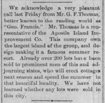
Leaving La Pointe our little party next visited the site of the Apostle Islands Improvement company’s new summer resort and found it all the most vivid fancy could have painted. Here, also, we met Peter Robedeaux, the oldest surviving voyager of the Hudson Bay Fur Co. Mr. Robedeaux is now in his 89th year, and is as spry as any man not yet turned fifty. He was born near Montreal in 1796, and when only fourteen years of age entered the employ of the Hudson Bay Fur Co., and visited the then far distant waters of the Columbia river, in Washington Territory. He remained in the employ of this company for twenty-five years and then entered the employ of the American Fur company, with headquarters at La Pointe. For fifty years this man has resided on Madeline Island, and the streams tributary to the great lake not visited by him can be numbered by the fingers on one’s hand. His life until the past few years has been one crowded with exciting incidents, many of which would furnish ample material for the ground-work of a novel after the Leather Stocking series style.
Wednesday, June 30, 1886, page 2.
GOLDEN WEDDING.
About thirty of the old settlers of Ashland and Bayfield went over to La Pointe on Saturday to celebrate the golden wedding anniversary of Judge John W. Bell and wife, who were married in the old church at La Pointe June 26th, 1836, fifty years ago. The party took baskets containing their lunch with them, the old couple having no knowledge of the intended visit. After congratulations had been extended the table was spread, and during the meal many reminiscences of olden times were called up.
Judge Bell is in his eighty-third year, and is becoming quite feeble. Mrs. Bell is perhaps ten or twelve years younger. Judge Bell came to La Pointe in 1834, and has lived there constantly ever since. La Pointe used to be the county seat of Ashland county, and prior to the year 1872 Judge Bell performed the duties of every office of the county. In fact he was virtually king of the island.
The visitors took with them some small golden tokens of regard for the aged couple, the coins left with them aggregating between $75 and $100.
Wednesday, July 20, 1887, page 6.
REMINISCENCES OF OLD LA POINTE
(Written for The Ashland News)

Visitors to this quiet and delapidated old town on Madeline Island, Lake Superior, about whom early history and traditions so much has been published, are usually surprised when told that less than forty years have passed since there flourished at this point a city of about 2,500 people. Now not more than thirty families live upon the entire island. Thirty-five years ago neither Bayfield, Ashland nor Washburn was thought of, and La Pointe was the metropolis of Northern Wisconsin.
Since interesting himself in the island the writer has often been asked: Why, if there were so many inhabitants there as late as forty years ago, are there so few now? In reply a great number of reasons present themselves, chief among which are natural circumstances, but in the writer’s mind the imperfect land titles clouding old La Pointe for the last thirty years have tended materially to hastening its downfall.

Captain John Daniel Angus
~ Madeline Island Museum
Of the historic data of La Pointe, of which the writer has almost an unlimited supply, much that seems romance is actual fact, and the witnesses of occurrences running back over fifty years are still here upon the island and can be depended upon for the truthfulness of their reminiscences. There are no less than five very old men yet living here who have made their homes upon the island for over fifty years. Judge John W. Bell, or “Squire,” as he is familiarly called, has lived here since the year 1835, coming from the “Soo,” on the brig, John Jacob Astor, in company with another old pioneer of the place known as Capt. John Angus. Mr. Bell contracted with the American Fur Co., and Capt. Angus sailed the “Big Sea” over. Mr. Bell is now eighty three years of age, and is crippled from the effects of a fall received while attending court in Ashland, in Jan. 1884. He is a man of iron constitution and might have lived – and may yet for all we know – to become a centenarian. The hardships of pioneer life endured by the old Judge would have killed an ordinary man long ago. He is a cripple and an invalid, but he has never missed a meal of victuals nor does he show any sign of weakening of his wonderful mind. He delights to relate reminiscences of early days, and will talk for hours to those who prove congenial. Once in his career, Mr. Bell had in his employ the famous “Wilson, the Hermit,” whose romantic history is one of the interesting features sought after by tourists when they visit the islands.
~ History of Northern Wisconsin, by the Western Historical Co., 1881.
Once Mr. Bell started an opposition fur company having for his field of operations that portion of Northern Wisconsin and Michigan now included within the limits of the great Gogebic and Penokee iron ranges, and had in his employ several hundred trappers and carriers. Later Mr. Bell became a prominent explorer, joining numerous parties in the search for gold, silver and copper; iron being considered too inferior a metal for the attention of the popular mind in those days.
Almost with his advent on the island Mr. Bell became a leader in the local political field, during his residence of fifty-two years holding almost continually some one of the various offices within the gift the people. He was also employed at various times by the United States government in connection with Indian affairs, he having a great influence with the natives.

Ramsay Crooks
~ Madeline Island Museum
The American Fur Co., with Ramsay Crooks at its head gave life and sustenance to La Pointe a half century ago, and for several years later, but when a private association composed of Borup, Oakes and others purchased the rights and effects of the American Fur Co., trade at La Pointe began to fall away. The halcyon days were over. The wild animals were getting scarce, and the great west was inducing people to stray. The new fur company eventually moved to St. Paul, where even now their descendants can be found.

Julius Austrian
~ Madeline Island Museum
Prior to the final extinction of the fur trade at La Pointe and in the early days of steamboating on the great lakes, the members of the well-known firm of Leopold & Austrian settled here, and soon gathered about them a number of their relatives, forming quite a Jewish colony. They all became more or less interested in real estate, Julius and Joseph Austrian entering from the government at $1.25 per acre all the lands upon which the village was situated, some 500 acres.

Joseph Austrian
~ Jennifer Barber Family
The original patent issued by the government, of which a copy exists in the office of the register of deeds in Ashland, is a literary curiosity, as are also many other title papers issued in early days. Indeed if any one will examine the records and make a correct abstract or title history of old La Pointe, the writer will make such person a present of one of the finest corner lots on the island. Such a thing can not be done simply from the records. A large portion of the original deeds for village lots were simply worthless, but the people in those days never examined into the details, taking every man to be honest, hence errors and wrongs were not found out.
Now the lots are not worth the taxes and interest against them, and the original purchaser will never care whether his title was good or otherwise. The county of Ashland bought almost the whole town site for taxes many years ago and has had an expensive load to carry until the writer at last purchased the tax titles of the village, which includes many of the old buildings. The writer has now shouldered the load, and proposes to preserve the old relics that tourists may continue to visit the island and see a town of “Ye olden times.”
~ The Boscobel Dial
September 29, 1885.
Originally the intention was to form a syndicate to purchase the old town. An association of prominent citizens of Ashland and Bayfield, at one time came very near securing it, and the writer still has hopes of such an association some day controlling the historical spot. The scheme, however, has met with considerable opposition from a few who desire no changes to be made in the administration of affairs on the island. The principal opponent is Julius Austrian, of St. Paul, who still owns one-sixth part of La Pointe, and is expecting to get back another portion of lots, which have been sold for taxes and deeded by the county ever since 1874. He would like no doubt, to make Ashland county stand the taxes on the score of illegality. As a mark of affection for the place, he has lately removed the old warehouse which has stood so many years a prominent landmark in La Pointe’s most beautiful harbor. Tourists from every part of the world who have visited the old town will join in regretting the loss and despise the action.
G. F. T.
To be continued in King No More…
Asaph Whittlesey Incidents: Number VIII
April 20, 2023
Collected & edited by Amorin Mello

Originally published in the April 6, 1878, issue of The Ashland Press. Transcribed with permission from Ashland Narratives by K. Wallin and published in 2013 by Straddle Creek Co.
… continued from Number VII.
Early Recollections of Ashland: Number VIII
by Asaph Whittlesey
We now offer a few comments upon our experience in common, and our appreciation of Doctor Edwin Ellis. I observe first that the inherent modesty of the man left him with next to no thought of himself in his “Early Recollections of Ashland,” and therefore the weightier of the task falling upon me. Had the question been raised “who is Dr. Ellis?” a proper reply would have been “Dr. Ellis is Dr. Ellis.”

In all my acquaintance I find no person more clearly identified than is this man. His manner of shaking hands, the music of his voice, and his unconscious habit of setting his hair on end, belong to no one but the man Edwin Ellis. For near a quarter of a century have I known him in the relationship of neighbor, physician, oarsman, farmer, speculator, preacher, merchant and as one skilled in back gammon, and can testify that he is a man who does with his might whatsoever his hands find to do. Those of us who were known as pre-emptors or town site claimants had occasion to regard the arrival of Dr. Ellis with no little suspicion, as certainly an emergency only would have induced him to make the trip from La Pointe during the most inclement season of the year. I remember well my anxiety to know whether or not he was a married man, and so direct were my inquiries as to this, that seemingly there was no way left but for him to satisfy our curiosity by simply saying yes or no. However we soon discovered that we were only wasting words in pressing the subject, and abandoned all further inquiry regarding it. Is it not strange that so good a man and one possessing so admirable a wife should be found so unwilling to satisfy our inquisitive minds in regard to this matter?
There was still another peculiarity noticeable in the Doctor, and that was his proclivity for secret organizations. He was chosen Chairman of a secret organization having for its object protection to pre-emptors from having their claims jumped, though one writer informs us that in the eye of the law they were all trespassers, – but by this means those holding claims felt a security in being absent from them the greater portion of their time. Perhaps the existence of this organization may explain why there has been so many little acres of early clearings discovered by brother Pratt, in the vicinity of Ashland.
Again, Dr. Ellis is one who thinks for himself, but is ever free to weigh the arguments of others, that he may be convinced of the right, and having formed his conclusion is outspoken, so that no one can mistake his position. Being of a hopeful and cheerful turn of mind, his company is courted. All in all whether as to his fitness for the life of a pioneer or as a neighbor and Christian friend I never knew a better.
I have been with him also in times of very great peril, when seemingly we were destined to a watery grave. But through presence of mind and well directed effort we succeeded in reaching the shore amid a feeling of profound gratitude toward our Great Protector above, for sparing our lives. As it is my intention hereafter to refer briefly to the history of a few of the ladies who first settled in and about Ashland. I will omit any special reference to Mrs. Ellis at this time.
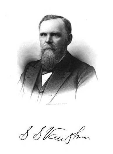
HON. SAMUEL S. VAUGHN
First arrived at La Pointe in 1852. At the time of my arrival there in 1854, I found him running a one horse store in an old frame building, standing in the sand near the present residence of George A. Stahl. So far as I am enabled to bring to mind the succession of events, my first sight of this man was at his own store where I invested in a very poor pocket compass, and this I soon after deposited on the copper range while upon an exploring trip with Ervin Leihy, Esq. Mr. Vaughn, however, claims that he first caught sight of me on the occasion of my aiding Rev. L. H. Wheeler in a social talk with the La Pointe people upon the subject of temperance one Sunday afternoon, in the store of Julias Austrian, Esq.

Reverend
Leonard H Wheeler
The leading man then engaged in the grocery business, as it was called, was one Peter B. Vanderventer, who subsequently left the country at a midnight hour rather than remain and meet a worse doom. Vanderventer was a large sized man and more a hellish countenance, and in exhibition of his bravery at the temperance meeting to which I have referred, he planted himself directly in front of me, and not more than three feet distant, so that I presume he did not mistake my language.
I cannot let slip the opportunity now furnished for informing the public of what seemed to me a rather severe practical joke inflicted upon Vaughn and Vanderventer, as it is too good to be lost, we will mention it right here. It seems that at the time Mr. Austrian made so extended entries of land upon the island, Messrs. Vaughn and Vanderventer discovered that Austrian had failed to enter a fraction shown upon the official plot, as reaching quite a distance into the bay, from what was known as Boyd’s Point and containing some forty acres or more. As La Pointe seemed likely to hold prominence as a business place, they saw the necessity of forthwith securing the tract of land in question. The two therefore suddenly disappeared amid the coldest days of a Lake Superior winter, and footed it under very adverse circumstances through to Willow River, something like one hundred and seventy-five miles, and returned, but yet were quite satisfied to know that they had secured to themselves what they had started for. From this time forward for several years these gentlemen paid their taxes promptly, until they finally employed a surveyor to re-survey and plot their promising possessions. Right here is where they discovered the point of the joke, by being informed that there was not a single foot of their land left, but all and much more had been washed away. Perhaps it was cruel in me to do so, but I could not resist making frequent inquiries as to their real estate.

Section 6 from 1852 GLO PLSS survey of T49N-R3W-4PM showing Boyds Point (now Grants Point) on Madeline Island.
Modern aerial imagery overlay showing Vanderventer & Vaughn’s Lot 3 lost to the sands of time (along with parts of Boyd & Rowley’s Lots 1 & 2).
In 1855 Vaughn removed his stock of goods to a building near where Thomas Stahl, Esq., now resides, where I often shared his bed and board, and it remains a pleasure to me to this day to testify to his qualities as a No. one cook, while biscuits of his make were entitled to special mention. It was a standing rule with him to have a controversy of words with Mr. McElroy, neither being specially noted for the refinement of their language. I think it was during the August term of the Circuit Court in 1860 that Mr. Vaughn and Andrew Tate were admitted to the practice of law before the Hon. S.N. Fuller, Judge of the Eighth Circuit of Wisconsin. It is said that they passed a very creditable examination.
This was the first term of Circuit Court held in the County of La Pointe, Elisha Pike being honored as foreman of the first grand jury convened within the county. Although Mr. Vaughn is but forty-eight years of age he can boast of having held the following positions of trust: Post-master, Justice of the Peace, Chairman of Town and County Boards, also member of the Wisconsin legislature in 1871, (having a constituency of 6,365 souls). In the practice of law his maiden effort was that of procuring papers of divorce in a somewhat renowned case. It is thought that but for the public trust which he held as a Chairman of the School Board he probably would never have known married life, – but as it was so foreordained they accepted the situation, while the people shouted, Amen!
On the arrival of business at Ashland in 1873, Mr. Vaughn removed his family to that place where he once more engaged as trader and forwarding and commission merchant.
To be continued in Number IX…
1827 Deed for Old La Pointe
December 27, 2022
Collected & edited by Amorin Mello
Chief Buffalo and other principal men for the La Pointe Bands of Lake Superior Chippewa began signing treaties with the United States at the 1825 Treaty of Prairie Du Chien; followed by the 1826 Treaty of Fond Du Lac, which reserved Tribal Trust Lands for Chippewa Mixed Bloods along the St. Mary’s River between Lake Superior and Lake Huron:
ARTICLE 4.
The Indian Trade & Intercourse Act of 1790 was the United States of America’s first law regulating tribal land interests:
SEC. 4. And be it enacted and declared, That no sale of lands made by any Indians, or any nation or tribe of Indians the United States, shall be valid to any person or persons, or to any state, whether having the right of pre-emption to such lands or not, unless the same shall be made and duly executed at some public treaty, held under the authority of the United States.
It being deemed important that the half-breeds, scattered through this extensive country, should be stimulated to exertion and improvement by the possession of permanent property and fixed residences, the Chippewa tribe, in consideration of the affection they bear to these persons, and of the interest which they feel in their welfare, grant to each of the persons described in the schedule hereunto annexed, being half-breeds and Chippewas by descent, and it being understood that the schedule includes all of this description who are attached to the Government of the United States, six hundred and forty acres of land, to be located, under the direction of the President of the United States, upon the islands and shore of the St. Mary’s river, wherever good land enough for this purpose can be found; and as soon as such locations are made, the jurisdiction and soil thereof are hereby ceded. It is the intention of the parties, that, where circumstances will permit, the grants be surveyed in the ancient French manner, bounding not less than six arpens, nor more than ten, upon the river, and running back for quantity; and that where this cannot be done, such grants be surveyed in any manner the President may direct. The locations for Oshauguscodaywayqua and her descendents shall be adjoining the lower part of the military reservation, and upon the head of Sugar Island. The persons to whom grants are made shall not have the privilege of conveying the same, without the permission of the President.
The aforementioned Schedule annexed to the 1826 Treaty of Fond du Lac included (among other Chippewa Mixed Blood families at La Pointe) the families of Madeline & Michel Cadotte, Sr. and their American son-in-laws, the brothers Truman A. Warren and Lyman M. Warren:
-
To Michael Cadotte, senior, son of Equawaice, one section.
-
To Equaysay way, wife of Michael Cadotte, senior, and to each of her children living within the United States, one section.
-
To each of the children of Charlotte Warren, widow of the late Truman A. Warren, one section.
-
To Ossinahjeeunoqua, wife of Michael Cadotte, Jr. and each of her children, one section.
-
To each of the children of Ugwudaushee, by the late Truman A. Warren, one section.
-
To William Warren, son of Lyman M. Warren, and Mary Cadotte, one section.

Detail of Michilimackinac County circa 1818 from Michigan as a territory 1805-1837 by C.A. Burkhart, 1926.
~ UW-Milwaukee Libraries
Now, if it seems odd for a Treaty in Minnesota (Fond du Lac) to give families in Wisconsin (La Pointe) lots of land in Michigan (Sault Ste Marie), just remember that these places were relatively ‘close’ to each other in the sociopolitical fabric of Michigan Territory back in 1827. All three places were in Michilimackinac County (seated at Michilimackinac) until 1826, when they were carved off together as part of the newly formed Chippewa County (seated at Sault Ste Marie). Lake Superior remained Unceded Territory until later decades when land cessions were negotiated in the 1836, 1837, 1842, and 1854 Treaties.
Ultimately, the United States removed the aforementioned Schedule from the 1826 Treaty before ratification in 1827.
Several months later, at Michilimackinac, Madeline & Michel Cadotte, Sr. recorded the following Deed to reserve 2,000 acres surrounding the old French Forts of La Pointe to benefit future generations of their family.
Register of Deeds
Michilimackinac County
Book A of Deeds, Pages 221-224

Michel Cadotte and
Magdalen Cadotte
to
Lyman M. Warren
~Deed.
Received for Record
July 26th 1827 at two Six O’Clock A.M.
J.P. King
Reg’r Probate

Bizhiki (Buffalo), Gimiwan (Rain), Kaubuzoway, Wyauweenind, and Bikwaakodowaanzige (Ball of Dye) signed the 1826 Treaty of Fond Du Lac as the Chief and principal men of La Pointe.

“Copy of 1834 map of La Pointe by Lyman M. Warren“ at Wisconsin Historical Society. Original map (not shown here) is in the American Fur Company papers of the New York Historical Society.
Whereas the Chief and principal men of the Chippeway Tribe of indians, residing on and in the parts adjacent to the island called Magdalen in the western part of Lake Superior, heretofore released and confirmed by Deed unto Magdalen Cadotte a Chippeway of the said tribe, and to her brothers and sisters as tenants in common, thereon, all that part of the said Island called Magdalen, lying south and west of a line commencing on the eastern shore of said Island in the outlet of Great Wing river, and running directly thence westerly to the centre of Sandy bay on the western side of said Island;
and whereas the said brothers and sisters of said Magdalen Cadotte being tenants in common of the said premises, thereafterwards, heretofore, released, conveyed and confirmed unto their sister, the said Magdalen Cadotte all their respective rights title, interest and claim in and to said premises,
and whereas the said Magdalen Cadotte is desirous of securing a portion of said premises to her five grand children viz; George Warren, Edward Warren and Nancy Warren children of her daughter Charlotte Warren, by Truman A. Warren late a trader at said island, deceased, and William Warren and Truman A. Warren children of her daughter Mary Warren by Lyman M. Warren now a trader at said Island;
and whereas the said Magdalen Cadotte is desirous to promote the establishment of a mission on said Island, by and under the direction, patronage and government of the American board of commissioners for foreign missions, according to the plan, wages, and principles and purposes of the said Board.

William Whipple Warren was one of the beneficiary grandchildren named in this Deed.
Now therefore, Know all men by these presents that we Michael Cadotte and Magdalen Cadotte, wife of the said Michael, of said Magdalen Island, in Lake Superior, for and in consideration of one dollar to us in hand paid by Lyman M. Warren, the receipt whereof is hereby acknowledged, and for and in consideration of the natural love and affection we bear to our Grandchildren, the said George, Edward, Nancy, William W., and Truman A. Warren, children of our said daughters Charlotte and Mary;
and the further consideration of our great desire to promote the establishment of a mission as aforesaid, under and by the direction, government and patronage of Board aforesaid, have granted, bargained, sold, released, conveyed and confirmed, and by these presents do grant, bargain, sell, release, convey and confirm unto the said Lyman M. Warren his heirs and assigns, out of the aforerecited premises and as part and parcel thereof a certain tract of land on Magdalen Island in Lake Superior, bounded as follows,

Detail of Ojibwemowin placenames on GLIFWC’s webmap.
that is to say, beginning at the most southeasterly corner of the house built and now occupied by said Lyman M. Warren, on the south shore of said Island between this tract and the land of the grantor, thence on the east by a line drawn northerly until it shall intersect at right angles a line drawn westerly from the mouth of Great Wing River to the Centre of Sandy Bay, thence on the north by the last mentioned line westward to a Point in said line, from which a line drawn southward and at right angles therewith would fall on the site of the old fort, so called on the southerly side of said Island; thence on the west by a line drawn from said point and parallel to the eastern boundary of said tract, to the Site of the old fort, so called, thence by the course of the Shore of old Fort Bay to the portage; thence by a line drawn eastwardly to the place of beginning, containing by estimation two thousand acres, be the same more or less, with the appurtenances, hereditaments, and privileges thereto belonging.
To have and to hold the said granted premises to him the said Lyman M. Warren his heirs and assigns: In Trust, Nevertheless, and upon this express condition, that whensoever the said American Board of Commissioners for foreign missions shall establish a mission on said premises, upon the plan, usages, principles and purposes as aforesaid, the said Lyman M. Warren shall forthwith convey unto the american board of commissioners for foreign missions, not less than one quarter nor more than one half of said tract herein conveyed to him, and to be divided by a line drawn from a point in the southern shore of said Island, northerly and parallel with the east line of said tract, and until it intersects the north line thereof.

Roughly 2,100 acres lies south of Middle Road.
And as to the residue of the said Estate, the said Lyman M. Warren shall divided the same equally with and amongst the said five children, as tenants in common, and not as joint tenants; and the grantors hereby authorize the said Lyman M. Warren with full powers to fulfil said trust herein created, hereby ratifying and confirming the deed and deeds of said premises he may make for the purpose ~~~
In witness whereof we have hereunto set our respective hands, this twenty fifth day of july A.D. one thousand eight hundred and twenty seven, of Independence the fifty first.
(Signed) Michel Cadotte {Seal}
Magdalen Cadotte X her mark {Seal}
Signed, Sealed and delivered
in presence of us }
Daniel Dingley
Samuel Ashman
Wm. M. Ferry
(on the third page and ninth line from the top the word eastwardly was interlined and from that word the three following lines and part of the fourth to the words “to the place” were erased before the signing & witnessing of this instrument.)
~~~~~~
Territory of Michigan }
County of Michilimackinac }
Be it known that on the twenty sixth day of July A.D. 1827, personally came before me, the subscriber, one of the Justices of the Peace for the County of Michilimackinac, Michel Cadotte and Magdalen Cadotte, wife of the said Michel Cadotte, and the said Magdalen being examined separate and apart from her said husband, each severally acknowledged the foregoing instrument to be their voluntary act and deed for the uses and purposes therein expressed.
(Signed) J. P. King
Just. peace
Cxd
fees Paid $2.25
Wisconsin Territory Delegation: La Pointe
April 23, 2016
By Amorin Mello
A curious series of correspondences from “Morgan”
… continued from The Copper Region.

The Daily Union (Washington D.C.)
“Liberty, The Union, And The Constitution.”
August 9, 1845.
La Pointe, Lake Superior
July 26, 1845
To the Editor of the Union:

View of La Pointe, circa 1843.
“American Fur Company with both Mission churches. Sketch purportedly by a Native American youth. Probably an overpainted photographic copy enlargement. Paper on a canvas stretcher.”
~ Wisconsin Historical Society
I have just time to state that, having spent five days at Copper Harbor, examining the copper mine, &c. at that place, and having got everything in readiness, we set off for this place, along the coast, in an open Mackinac boat, travelling by day, and camping out at night. We reached this post on yesterday, the 25th instant. We have now been under tents 21 nights. In coming up the shore of the lake, we on one occasion experienced a tremendous rain accompanied with thunder, which wetted our things to a considerable extent, and partly filled the boat with water.
On our way we spent a good part of a day at Eagle river, and examined the mine in the process of being worked at that place, but found it did not equal our expectations.
We also stopped at the Ontonagon, the mineral region bordering which, some fifteen miles from the lake, promises to be as good as any other portion of the mineral region, if not better.
I have not time at present to enter fully into the results of observations I have made, or to describe the incidents and adventures of the long journey I have performed along the lake shore for the distance of about 500 miles, from Sault Ste. Marie to La Pointe. There are many things I wish to say, and to describe, &c.; but as the schooner “Uncle Tom,” by which I write, is just about leaving, I have not time at present. I must reserve these things for a future opportunity.
I am, very respectfully,
Your obedient servant,
MORGAN.
P.S. – I set off in a day or two for the Mississippi and Falls of St. Anthony, via the Brulé and St. Croix rivers.
Yours, &c., M.
The Daily Union (Washington D.C.)
“Liberty, The Union, And The Constitution.”
August 25, 1845
EDITOR’S CORRESPONDENCE
—
[From our regular Northern correspondant.]
La Pointe, Lake Superior,
July 28, 1845.

Map of the Mineral Lands Upon Lake Superior Ceded to the United States by the Treaty of 1842 With the Chippeway Indians.
~ Wisconsin Historical Society
In what I said in my last letter of this date, in relation to the extent, value, and prospects of the copper-mines opened on Lake Superior, I had no wish to dampen the ardor, would the feelings or injure the interest of any one concerned. My only wish is to state facts. This, in all cases, I feel it my duty to do; although, in so doing, as in the present case, my individual interest suffers thereby. Could I have yielded to the impulses and influences prevailing in the copper region, I might have been greatly benefited in a pecuniary point of view by pursuing a different course ; but, knowing those whom I represented, as well as the public and the press for which I write, wanted the truth, the whole truth, and nothing but the truth, I could do nothing less than make the statement I did. Previous to visiting the country, I could, of course, know nothing of its real character. I had to judge, like others, from published reports of its mineral wealth, accompanied with specimens, &c., which appeared very flattering; but which, I am now convinced, have been rather overdrawn, and the mineral region set out larger and richer than it really is. The authors of the reports were, doubtlessly, actuated by pure motives. They, no doubt, had a wish, in laying down the boundaries of the mineral region, so to extend it as to leave out no knoll or range of trap-rock, or other formation, if any indicative of mineral deposites, which usually appear in connexion with them, occurred.
I consider, in conclusion, that the result thus far is this: that the mines opened may possibly, in their prosecution, lead to rich and permanent veins; and probably pay or yield something, in some cases, while exploring them. But, however rich the specimens of one raised, at present there is nothing in them, geologically speaking, that indicates, conclusively, that they have reached a vein, or that the mines will continue permanently as rich as they are at present. This would be my testimony, according to the best of “my knowledge and belief,” on the witness’s stand, under oath.
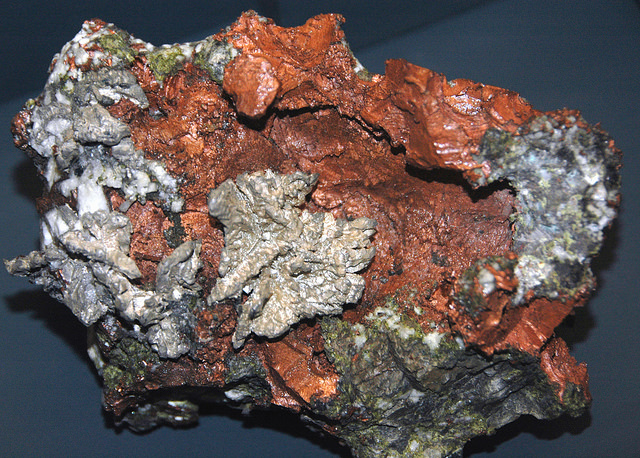
“The remarkable copper-silver ‘halfbreed’ specimen shown above comes from northern Michigan’s Portage Lake Volcanic Series, an extremely thick, Precambrian-aged, flood-basalt deposit that fills up an ancient continental rift valley.”
~ Creative Commons from James St. John
That the region, as before said, is rich in copper and silver ores, cannot be denied. And I think the indications that veins may or do exist somewhere in great richness, are sufficiently evident to justify continued explorations in search of them, by those who have the means and leisure to follow them up for several years. To find the veins, and most permanent deposites, must be the work of time; and as the season is short, on Lake Superior, for such operations, several years may be necessary before a proper and practical examination can be made of the country.
The general features of Lake Superior are very striking, and differ very much in appearance from what I have ever met with in any other part of the continent. The vastness and depth of such a body of pure fresh cold water so far within the continent, is an interesting characteristic. When we consider it is over 900 feet deep, with an area of over 30,000 square miles, and yet that, throughout its whole extent, it presents as pure and as fresh-tasted water as though it were taken from a mountain brook, the question naturally arises, Where can such a vast supply of pure water come from? It is true, it has great many streams flowing into it, but they are nearly all quite small, and would seem to be wholly inadequate to supply such a vast mass of water, and preserve it in such a state of purity. The water supplied by most of the rivers is far less pure than that in the lake itself. East of Keweena point, we found the water of the rivers discolored, being tinged by pine and other roots, clay, &c., often resembling the hue of New England rum. Such rivers, or all combined, would seem to be inadequate to supply such a vast quantity of pure clear water as fills this inland ocean!
~ United States Geological Survey
It is possible that this great lake is freely supplied with water from subterranean springs opening into it from below. The river St. Mary’s also seems inadequate, from its size, to discharge as much water as comes into the lake from the rivers which it receives. In this case, evaporation may be so great as to diminish the water that would otherwise pass out at it.
As relates to tides in the other lakes, we have nothing to say; but, as far as Lake Superior is concerned, we feel assured, from observation, as well as from the reports of others upon whom we can rely, that there are tides in it – variously estimated at from 8 to 12 inches; influenced, we imagine, by the point of observation, and the season of the year at which such tides are noticed.
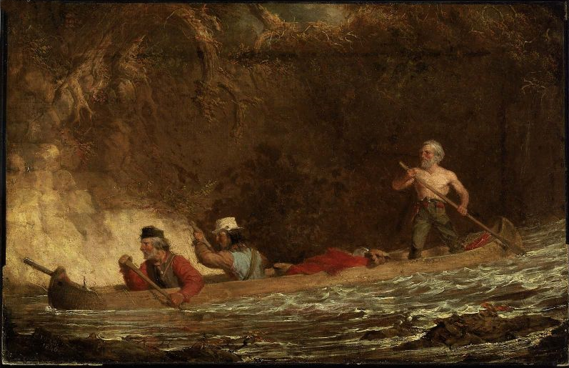
The Voyageurs (1846) by Charles Deas.
~ Commons.Wikimedia.org
What strikes the voyageur with the most interest, in the way of scenery, is the wild, high, bold, and precipitous coast of the southern shore, for such much of the whole distance between Grand Sable and La Pointe, and, indeed, for some distance beyond La Pointe ; the picturesque appearance of which often seemed heightened to us, as on a clear morning, or late afternoon, or voyageurs would conduct our boat for miles near their bases. Above us, the cliffs would rise in towering heights, while the bald eagle would be soaring in grand circular flights above their summits; our voyageurs, at the same time, chanting in chorus many of their wildest boat songs, as we glided along on the smooth and silent bosom of the lake. I have heard songs among various nations, and in various parts of the world; but, whether it was the wild scenery resting in solemn grandeur before me, with the ocean-like waste of water around us, which lent wilderness to the song, I never listened to any which appeared to sing a verse in solo, and then repeat a chorus, in which the whole crew would join. This would often be continued for several miles at a time, as the boat glided forward over smooth water, or danced along over the gentle swells of a moderate sea; the voyageurs, at the same moment, keeping time with their oars.
Jean Baptiste, our pilot, had an excellent voice, full, loud, and strong. He generally led off, in singing; the others falling in at the choruses. All their songs were in French, sometimes sentimental or pathetic, sometimes comic, and occasionally extempore, made, as sung, from the occurrences of the preceding day, or suggested by passing scenes.
The Chippewa Indians are poor singers; yet they have songs (such as they are) among them; one of which is a monotonous air repeated at their moccasin games.
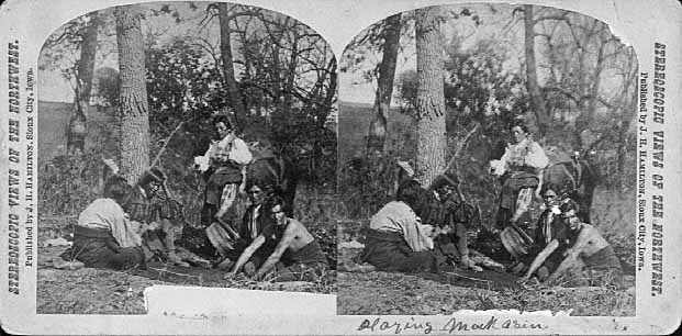
Stereographic view of a moccasin game, by J. H. Hamilton, 1880.
~ University of Minnesota Duluth
Next to the love of liquor, many of the Indians have a most unconquerable passion for gambling. While at La Pointe, I had an opportunity of seeing them play their celebrated moccasin game. They were to the number of two, or three aside, seated on the ground opposite to each other, which a blanket spread out between them, on which were placed four or five moccasins. The had two lead bullets, one of which was made rough, while the other remained smooth. Two f the gamesters were quite young men, with their faces painted with broad horizontal red and blue stripes, their eyelashes at the same time being dyed of a dark color. They played the game, won and lost, with as much sang froid as old and experienced gamblers. Those who sat opposite, especially one of them, was much older, but no means a match, at the time of my visit, for the young rascals, his antagonists. One takes the balls in his hands, keeps his eye directly on the countenance of the opposite party, at the same time tossing the balls in his hands, and singing, in a changing voice, words which sound somewhat like “He-he-hy-er-he-he-hy-er-haw-haw-haw-yer. He-he-hy-er,” &c. During which he keeps raising, shifting, and putting down the moccasins, till, finally, he raises his hands, having succeeded in concealing the balls under two of the moccasins, for which the other proceeds to search; and if he succeeds, on the first trial, in finding the rough ball, he wins. Then he takes the balls to hide, and commences singing himself. If he fails, he loses; and the first party repeats the song and the secretion of the balls. They hold in their hands small bundles of splinters of wood. When one loses, he gives to the winner so many sticks of wood. A certain number of them gained by any one of the party, wins the game. When I saw them, they had staked up their beads, belts, garters, knife-cases, &c. Their love of gaming is so strong, as to cause them to bet and lose everything they possess in the world – often stripping the last blanket from their naked backs, to stake on the game. It is said that some Indians acquire so much dexterity at this game, that others addicted to it refuse to play with them. In playing the game, they keep up a close watch on each other’s eyes, as being the best index to the movement of the hands. The song is repeated, no doubt, to diver the attention of the antagonists.
Among other peculiarities of Lake Superior, and one of its greatest recommendations, is the abundance and superiority of its fish, consisting of trout of large size, white fish, siskomit, ( a species of salmon,) and bass. The trout and siskomit are the finest and noblest fresh-water fish I ever saw. Almost every day we could catch trout by trailing a hook and line in the water behind out boat. In this way we caught one fine siskomit. Its meat, when fresh-cooked, we found about the color of salmon. The fish itself is about as heavy as a common-sized salmon, but less flat, being more round in form.

Detail of “The 12 Apostles” from Captain Jonathan Carver’s journal of his travels with maps and drawings, 1766.
~ Boston Public Library
If you will look at a map of Lake Superior, you will find, near its upper end, a labyrinth of islands, called by the early French voyageurs, of whom P. Charlevoix was one, (a Jesuit,) “the Madelaine islands.” They are sometimes called “the Twelve Apostles.” The largest island is now generally known as “the Madelaine island” – being the largest of the group. Just inside, and near its southern extremity, at the head of a large, regular bay, with a sandy beach, with an open and gently-rising scattered pine and spruce land in the rear of the beach, stands La Pointe – one of the most pleasant, beautiful, and desirable places for a residence on Lake Superior, and the very place where Fort Wilkins should have been placed, instead of its present location, which must be conceded, by every impartial person, to be among the very worst that could have been selected on the whole lake.
The garrison at Copper harbor, located, as it is, upon the rocky surface of trap conglomerate, affording a surface so scantily supplied with soil amidst masses of pebbly rock and trap fragments as to be wholly unfit for any sort of cultivation whatever, is altogether out of place. It is wholly inaccessible by land, and can only be reached by water in summer. It is at a spot where Indians usually never passed within forty miles of it, till since its occupation.
Detail of the Indian trail or “mail route” between La Pointe and St. Anthony Falls.
~ A new map of the State of Wisconsin, by Thomas, Cowperthwait & Co., 1850
The very next Congress should direct its prompt removal to La Pointe. Here, from the foot of the bay in front of the Madelaine island, there is an Indian trail, connecting La Pointe with St. Anthony’s Falls, and over which the mail is carried in winter by voyageurs on foot. La Pointe is the favorite resort of the Indians. Their lodges, in villages, bark canoes, &c. are found here the year round.
They delight to paddle and sail their canoes about the beautiful bays, harbors, &c. of these islands, employing their time in canoe building, hunting, fishing, &c. At every annual payment of their annuities, they flock to La Pointe in great numbers. Not only is that section of the great Chippewa nation sharing in the annuities brought together, but large parties of the same tribe, who receive no annuity, come at the same time from the British possessions to the north of Pigeon river. The Chippewas, called the “Pillageurs,” (so called from their thievish propensities,) inhabiting the country about Mille and Leech lakes, also attend – to meet relations, to traffic , and, perhaps, to steal a little. The great advantage of a government outpost is felt in the moral effect it exercises over the Indians. I know of no place where this influence would be more decidedly and beneficially exerted than at La Pointe. here should be daily unfurled the “stars and stripes,” and the sound of the evening gun be heard over the beautiful bays, and along the shores of the Twelve Apostles, which the Indians would learn to reverence with little less respect than they do the voice of the Manitou – the guardian spirit of the mines, embowelled in the dark trap hills of the lake.
Here, too, is an exceedingly healthy place, a good soil, and every convenience for raising the finest potatoes, turnips, and every kind of garden stuff.

1856 oil painting of Doctor Charles William Wulff Borup, a native of Copenhagen, Denmark. Borup married Elizabeth Beaulieu, a Lake Superior Chippewa daughter of Bazil Hudon Beaulieu and Ogimaagizzhigokwe. Borup and his brothers-in-law Charles Henry Oakes and Clement Hudon Beaulieu were co-signers of the 1842 Treaty with the Chippewa at La Pointe. Borup and Oakes became the first bankers of Minnesota.
Dr. Borup, the agent for the American Fur Company, (who have an extensive trading-post at this place,) has a superb garden. In walking through it with him, I saw very fine crops of the usual garden vegetables growing in it. His red currant bushes were literally bent down beneath their weight of ripe fruit. His cherry-trees had also borne well. Gooseberries also succeed well. The doctor also had some young apple-trees, that were in a thriving condition. Poultry, likewise, does well. Mrs. B. had her yard well stocked with turkeys, geese, ducks, and chickens. There was also a good garden at the mission-house of the American board.
However infinitely better is such a place for a United States garrison than Copper harbor, located, as it were, on a barren rock, where no Indians are seen, unless induced to go there by the whites – where there is nothing to protect – where intercourse is cut off in winter, and food can only reach it in summer – where there is no soil on which to raise a potato or a cabbage. I can only say that a greater blunder, in the location of a military post, was probably never committed. And if made (of which I am assured it was not) by a military man, he ought to be court-martialed and cashiered.
The mouth of the Ontonagon river is a far better spot for the fort than Copper harbor. It has a good soil, and a beautiful site for a fort. Furthermore, the country between it and Fort Winnebago, on the Wisconsin river, is favorable to the construction of a military road, which ought, at no distant day, to be opened. Another road should be cut from Fort Snelling, near the falls of St. Anthony, to La Pointe. In cutting these roads, it would seem to me as if the United States soldiers themselves might be usefully employed.
~ FortWiki.com
While at Copper harbor, I frequently visited Fort Wilkins, in command of Captain Cleary, whom I consider in every way an ornament and an honor to the service. In the brief space of time he has been at this post, and with the slender materials at command afforded by the country, he has nevertheless succeeded in making an “oasis” in a wilderness. He has erected one of the neatest, most comfortable, and best-planned garrisons it has been my lot to enter on the western frontier. He keeps all in excellent condition. His men look clean, healthy, and active. He drills them daily, and keeps them under most excellent discipline. He seems to take both pleasure and ride in the service. He says he never has any difficulty with is soldiers while he can exclude ardent spirits from them, as he succeeds in doing here, notwithstanding the great number of visitors to Copper harbor this summer.
To all travellers who are interested in objects of leading curiosity, the character of the Indians they fall in with cannot fail to arrest a share of attention.
The Chippewas are the only Indians now met with from the Sault Ste. Marie and Mackinac, extending from thence west along the southern shore of Lake Superior, to Fond du Lac, and from thence, in the same direction, to the Mississippi river. Within the United States they extend over the country south from the British boundary, to the country low down on the St. Croix and Chippewa rivers. The same tribe extends from our boundary northwest of the lake, entirely around its northern shore on British territory, till they reach the Sault Ste. Marie, opposite the American shore. It is said this tribe, spread over such a vast tract of country, is a branch of the powerful race of the Algonquins. They are sometimes called O-jib-was. They do not exist as a consolidated nation, or strictly as a confederation of bands. The entire nation on both sides of the line is divided into a great number of bands, with a chief at the head of each, which not uncommonly go by his name, such as “Old Martin’s band,” “Hole in the Day’s band,” &c.
The chief’s son, especially if he exhibits the right qualities, is expected to succeed his father at the head of the band; but very frequently the honor is reached by usurpation. The whole nation, which widely differ in circumstances, according to the part of the country they inhabit, nevertheless all speak the Chippewa language, and have extensive connexion by marriage, &c. The bands inhabiting the southern shore of Lake Superior are by far the best of any others. Though polygamy still prevails among them, and especially among their chiefs, it is nevertheless said to be becoming less common, especially where they are much influenced by Catholic and other missions. While at La Pointe, an Indian wedding was consummated, being conducted according to the ceremonies of the Catholic church, and performed by the missionary priest of that persuasion stationed at the Pointe.
There is one trait of character possessed by the Chippewas, (if we except, perhaps, the band of “pillageurs,” who have a kind of “Bedouin Arab” reputation among their countrymen,) which, I am sorry to say, the whites do not possess in an equal degree – that is, “very great honesty.”
White men can travel among them with the most perfect safety as to life and property. I will venture to say, that a man may carry baskets filled with gold and silver, and set them down in Indian villages, or leave them lying where he likes, or go to sleep by them, with Indians encamped all around him, and not one cent will be touched. Such a thing as a house being broken open and robbed at a Chippewa Indian trading-post was never heard of – within between two and three years’ intercourse with them – in time of peace. Dr. Borup said he would not be afraid, if concealed to look on, to leave his store door open all night; and the fact alone of its being left open, might be made known to the Indians at the Pointe. He would expect to see no Indian enter the store, nor would he expect to lose anything; such was his confidence in their honesty!!
Last winter, flour at the Pointe rose to $40 per barrel. The poor Indians were nearly famished for bread, but were unable to purchase it at such a price. They knew the American Fur Company had a considerable lot in store, guarded by nothing stronger than a padlock, yet they never offered the least violence towards the company’s agents or store! Would white people have acted as honestly? The poor Indians, by nature honest, have too often known the whites by the wrongs inflicted upon them, which God can forgive, but time can never blot out! They are very superstitious, but not as basely and insanely so, but a great deal, as the Mormons, Millerites, and other moon-stricken sects among the whites. They believe in one Great and Good Spirit, or a Being who can at will inflict good or evil on mankind; and there’s an end of it. They often denominate the mysterious spirit of evil import the Manitou, making him to dwell in the wild hills, islands, grottoes, and caves of Lake Superior.
From these huge birds the Indians obtained their first knowledge of fire, which they kindled with fire-sticks. These mythical birds were the most powerful of the animal deities of the Indians of the woodlands and of the plains. When the weather was stormy they flew about high in the heavens. When they flapped their great wings, one heard the crashes of thunder, when they opened and closed their eyes flashes of lightning were seen. Some carried lakes of water on their backs, these slopped over and caused downpours of rain. Their arrows, or thunderbolts, were the eggs which they dropped in their flight. These shattered the rocks and set fire to the forests and prairies.
A Chippewa Indian hunter, who was carried away to his nest by a Thunderer, saved his life by killing one of the young birds and flying back to earth in its feathered hide.
In the Smoky Mountains, a wild and rugged region in the southwestern part of Bayfield County, was the home of Winneboujou (Nenebozho), the fabled hero of the Ojibwa Indians. This all-powerful manitou was a blacksmith, and had his forge on the flat top of the highest mountain. Here he shaped the native copper of the Lake Superior region into useful implements for his Indian children. Much of his work at his forge was done at night, and the ringing blows of his great hammer could be heard throughout the Brule Valley and Lake Superior region. The fire of his forge reddened the sky. When he was not busy at his forge he was away hunting or seeking other adventures. Many stories of the exploits of this giant manitou have been told by the Chippewa and other Wisconsin Algonquian tribes.”
~ Legends of the Hills of Wisconsin by Dorothy Moulding Brown; The Wisconsin Archaeologist, Volume 18, Number 1, 1937, pages 20-21.
At times, it is said, a peculiar noise issues from the Porcupine mountains, and from the high hills on the main land, both east and west of La Pointe, some distance off. It is said to resemble the distant discharge of ordnance, or thunder. At one time, they said it was so loud and frequent, that they mistook it for signal guns fired from the brig Astor, which they thought might be in distress, and actually sent out a boat in search of her.
“Ojibwe shoulder pouch depicting two thunderbirds in quillwork, Peabody Museum, Harvard University.”
~ Commons.Wikimedia.org
These sounds the Indians believe to be the voice of the spirit “Manitou,” who guards the deposites of mineral wealth embowelled beneath the hills, and to whom any attempt made to dig them up, and carry them off, would be highly offensive, and followed by some kind of punishment. I have never yet heard of an Indian’s leading a white man to a locality of copper, or telling where he has found a piece when picked up!
Some have supposed that the noise in question arises from volcanic action; but, as no vibration is felt in the earth, and no other proof exists of such being the case, we are led to believe that the noise is produced by the lashing of the waves of the lake after a storm, as they are driven forward into the grottoes, caves, &c. of the tall sandstone cliffs, formed at their bases by the disintegrating effects of water and ice. Some distance east of La Pointe, about the Little Girl’s Point and Montreal river, as well as west of the same place, some fifteen or twenty miles, high red sandstone cliffs occur. At their bases, near the water’s edge, a great many curiously-shaped caves and grottoes appeared. In places, the sandstone had been so cut away, that only pillars remained standing at some ten or fifteen feet in the lake, from the top of which a high rude arch would extend to the main shore, and beneath which boats could easily pass. This was particularly the case near where the islands are parted with going west up the southern shore of the lake. Some caves, with small openings for mouths, run for a long distance back beneath the hills, expanding, likely, into large halls with high vaulted roofs, &c. After a storm, a heavy sea continues to roll into these grottoes and caverns, the waves lashing themselves against their sides and roofs – thus producing sounds resembling those heard at La Pointe, &c.
As the weather is generally calm after a storm, before the sea goes down, it is likely at such times these sounds are heard.
We had occasion to pass these places when a considerable sea would be on, close to the cliffs, and could hear the hollow heavy sounds of the waves as they broke into the caverns within the cliffs and hills. Every day, while we remained, parties of Indians continued to arrive, to be present at the payment.
We finally became prepared to leave for the Mississippi, having bought two bark canoes, and hired four new voyageurs – two for each canoe – one Indian, one half-breed, and two descendants of Canadian French; and, with a stock of provisions, we were ready to be off. From this place, I sent back three voyageurs to the Sault Ste. Marie, all that I hired to come as far as La Pointe. So, after paying our respects to Mr. Hays, our worthy Indian agent, and to Dr. Borup, (to both of whom I had borne letters of introduction,) and having many “bon voyages” heaped upon us by our friends and the friends of the voyageurs, we bade adieu to La Pointe.
You will not hear from me again till I reach the Falls of St. Croix.
I am yours, very truly, &c.
MORGAN.
To be continued in Saint Croix Falls…
Barber Papers: “Apostle Islands” Summer of 1857
February 13, 2016
By Amorin Mello
Selected letters of the Joel Allen Barber Papers
… continued from the Spring of 1857.
This season (Summer of 1857) of the Barber Papers begins with this editorial commentary from Chequamegon History because the Barber Papers do not contain much information about events that occurred during this time period. Fortunately, letters from Giles Addison Barber preceding this season indicate that he had planned to take his second trip west from Vermont to Lake Superior in order to rejoin his son Joel Allen Barber during the Summer of 1857.
Giles’ first trip in the Spring of 1856 was tragically disrupted by the death of his first son Augustus Hamilton Barber, and was unprepared to reconcile Augustus’ unfinished copper claims, land speculations, and U.S. General Land Office survey contracts during that trip. The vocabulary Giles used to describe employees and politics at the U.S. General Land Office in Superior City were not admirable. Giles sought reconciliation by applying pressure upon national politicians in his social network (particularly Alvah Sabin; U.S. Representative from Vermont), and began preparations for this second trip.
Augustus Hamilton Barber had begun to work closely with George Riley Stuntz earlier in 1852 to survey the far northwestern region of the Wisconsin Territory; their most recent survey together before the Summer of 1857 had been at the Gardens in Odanah of the LaPointe Indian Reservation during the Fall of 1856. Stuntz’s nephew Albert Conrad Stuntz began surveying the Gogebic Iron Range of La Pointe County during the Summer of 1857. Lysander “Gray Devil” Cutler moved to Ironton during the Summer of 1857 as the new managing agent on the Gogebic Iron Range for the Wisconsin & Lake Superior Mining & Smelting Company to operate in collusion with Stuntz’s survey of the Gogebic Iron Range for the U.S. General Land Office.
“Mr. Cutler was appointed the managing agent of this prospective Wisconsin bonanza, at a fair salary, to which was added a liberal amount of the stock of the company. His first task was to perfect the title to the property, and the first step toward it was to take a personal view of the situation and the property. It was a somewhat arduous undertaking, not unfraught with danger. Excepting two or three traders and surveyors, who had stock in the company, the population, which consisted mostly of Indians and half-breeds, viewed this incursion of wealth-hunters from the lower lakes with suspicion and distrust. To add to the difficulties of the situation, other parties owning Sioux script were endeavoring to acquire a title to the mineral range. One man working in the interest of the company the year before, had been discovered, after being missed for some weeks, dead in the forest, near the range. Bruises and other indications of violence on the body gave strong ground for the belief that he had been murdered. Altogether it was a position, the applications for which were not numerous. His [Cutler’s] first trip was made in the Summer of 1857.”
~ History of Milwaukee, Wisconsin:
From Prehistoric Times to the Present Date
Milwaukee Genealogical Society, 1881, page 790.

“IN MEMORY OF
AUGUSTUS H. BARBER
of Cambridge, Vt. U.S. Deputy Surveyor
who was drowned in
Montreal River
Apr. 22. A.D. 1856
Aged 24 yrs. & 8 ms.”
~ FindAGrave.com
The death of this unnamed managing agent that Cutler replaced corresponds with the timing of Augustus’ death in the Spring of 1856. Augustus’ last letters reveal that he had gotten into “A Little Trouble“ and decided to “Let ‘Em Rip“ shortly before his death. Augustus was reported to have drowned below Superior Falls near Ironton and the Mouth of the Montreal River. However, a confidential letter written by Giles to Allen on the first year anniversary of Augustus’ death reveals that the location actually occurred further inland under secret circumstances:
“It must remain a sealed book to us, how Augustus was hurried out of the woods, and why it was so ordained if there, was any ordination about it, till we meet him in another world, which I devoutly hope we may do though I am sorry to say more hoping than expecting.”
Augustus is suspected to have been the unnamed managing agent found dead near the Gogebic Iron Range that Cutler replaced. There was a footpath between the Gogebic Iron Range and Ironton, which supports this speculation. James Smith Buck was an elected official of La Pointe County during the Summer of 1857, and wrote memoirs about working in the Penokee Survey Incidents with Cutler and Stuntz. Buck’s memoirs glorified another traumatic event at Ironton which involved Cutler and his management approach to disciplining the mining company’s Lake Superior Chippewa employees at these locations. Buck did not make any references to the Barbers in his memoirs; however, Asaph Whittlesey published a public retort to Buck’s memoirs with a cryptic allusion to “the Siege of Barlisle“. Whittlesey’s reference is suspected to have been about the murder of Augustus Hamilton Barber.
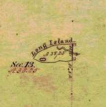
Detail of Chequamegon Point included in the Barber brother’s survey of T47N R4W during the Summer of 1855.
Without further speculation about how the Barber family may have been involved with the 1857 Stuntz/Cutler survey of the Gogebic Iron Range, the rest of this will be dedicated to the 1857 Barber survey of we can focus on the Barber brothers’ survey of what is now the Apostle Islands National Lakeshore.
Joel Allen Barber and his brother Augustus Hamilton Barber began their work to survey the Apostle Islands at Chequamegon Point on Long Island during the Summer of 1855. Augustus and Allen continued their survey of the Apostle Islands during the Winter of 1856:
“We shall go back in a few days and commence surveying around the islands. Now don’t fancy that we cannot survey in the winter, for we have tried it and know better.”
After Augustus’ death, Allen rewrote their original field notes of the Apostle Islands survey during the Winter of 1857, per instructions from their father:
“Keep a strict acct of all the expense of resurveying on the last winters contract, if you get a new one & undertake it, as I am informed that I can get relief from Congress by a special act, paying me all that it will cost to do the work over again, which will be as much for you interest as anybody’s of this please say nothing to any one.”
Allen then renewed their contract for this survey during the Spring of 1857, causing much anxiety for their father despite giving instructions to do this:
“I am surprised to learn that you are going to survey islands so late in the season. Nothing that I can now say will avail any thing else I would caution against trusting too long to the treacherous covering over the dark blue waters. I hope you will have good success and get through without any fatal accidents to your self or to any one of your party.”
The Barbers’ survey field notes were finally accepted as complete by the U.S. General Land Office during this season; the Summer of 1857.
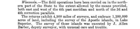
“… the survey of the Apostle Islands, in Lake Superior. The survey of those islands was executed by J. Allen Barber, deputy surveyor, with unusual care and trouble.”
~ Message of the President of the Untied States to the Two Houses of Congress at the Commencement of the Second Session of the Thirty-Fifth Congress, 1858, page 119.
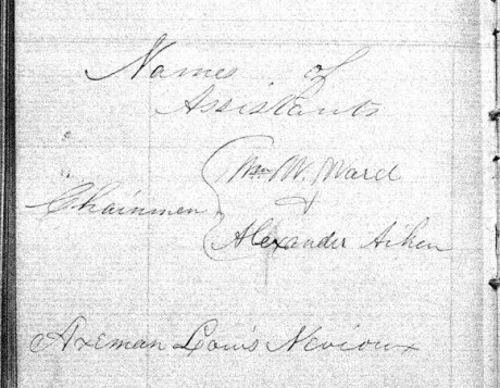
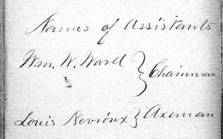
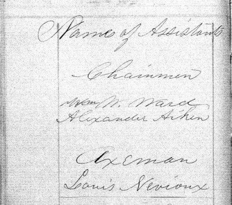
The following documents are the original surveys notes of the Apostle Islands as submitted by Deputy Surveyor Joel Allen Barber during the Summer of 1857. Augustus Hamilton Barber’s former role in these surveys during 1855 and 1856 was not mentioned anywhere in his brother’s survey notes. In lieu, Joel Allen Barber identified three assistants during these surveys:
- William W Ward
- Alexander Aiken
- Louis Nevioux
Aiken and Neveau are familiar surnames in Lake Superior Chippewa communities.
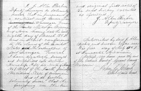
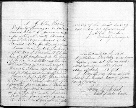
Our transcriptions of selected letters from the Joel Allen Barber Papers are continued below without further editorial commentary:
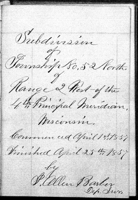
Exterior Field Notes
Township 51 North, Range 2 West
Township 52 North, Range 1 West
Township 52 North, Range 2 West
Township 53 North, Range 1 East
Township 53 North, Range 1 West
Township 53 North, Range 2 West
April 1857
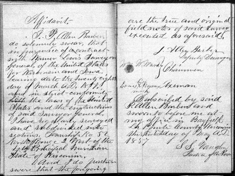
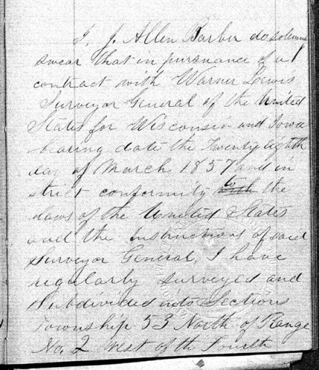
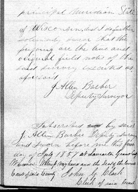
Notebook ID: EXT27501
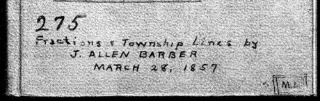
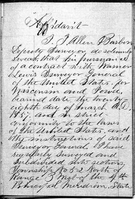
Joel Allen Barber received this survey contract on March 28th, 1857, from Warner Lewis at the General Land Office in Dubuque, Iowa.
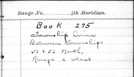
“Township Lines Between Townships 51 & 52 North, Range 2 West”
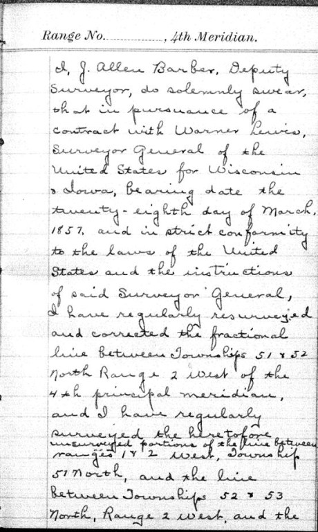
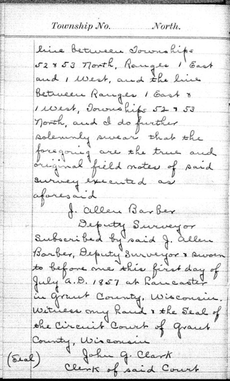
These survey notes were originally sealed in Lancaster, Grant County, on July 1st, 1857.


Interior Field Notes
Barber, J. Allen
Mar. 1857
Notebook ID: INT011E03

“No. 11 T. 46-47-52-&53. R. 1. East”
Township 46 North, Range 1 East
[Joel Allen Barber’s survey notes for this township are referenced by the the Wisconsin Public Land Survey Records, but is are omitted from the General Land Office Records. A survey map published by Charles Whittlesey in 1860 reveals diverse geology, one mineral claim, and part of the ancient Flambeau Trail were documented in this township.]

Detail of T46N-R1E and the surrounding region from Charles Whittlesey’s Geological Map of the Penokie Range, 1860.
Township 47 North, Range 1 East
[One more minor Chequamegon History editorial commentary: Joel Allen Barber’s survey notes of this township are referenced by the Wisconsin Public Land Survey Records, but are omitted from the General Land Office Records. This township is featured in the above detail of Whittlesey’s 1860 map. It is near Ironton; and contains the Mouth of the Montreal River, Superior Falls, and Saxon Falls.]

Superior Falls at the mouth of the Montreal River, as featured in the stereograph “View on Montreal River” by Whitney & Zimmerman from St. Paul, circa 1870.
~ Wikimedia Commons
Township 52 North, Range 1 East
Barber’s survey of T52N R1E included the southeast corner of Outer Island, the rest of this township is occupied by Lake Superior. There are no survey notes available for this township, it was included in the survey of T53N R1E for convenience.
Township 53 North, Range 1 East

Barber’s survey of T53N R1E features the east half of Outer Island, the rest of this township is occupied by Lake Superior.
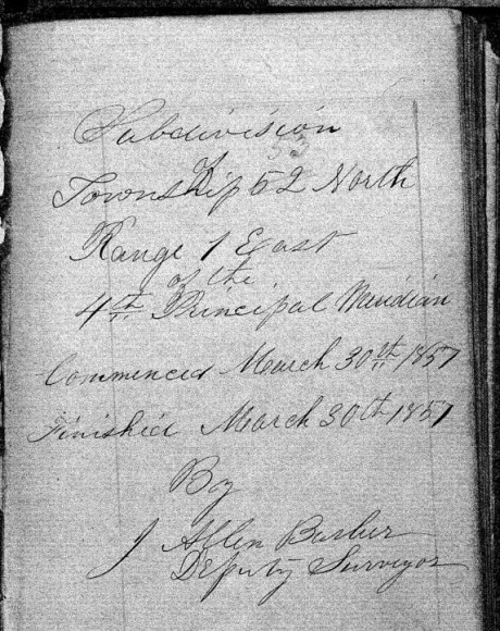
“Commenced March 30th, 1857. Finished March 30th, 1857.”

Barber’s assistants were William W. Ward, Alexander Aiken, and Louis Nevioux.

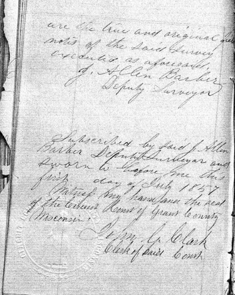
These survey notes were sealed in Lancaster, Grant County, on July 1st, 1857. Barber’s assistants were not signatories.
Interior Field Notes
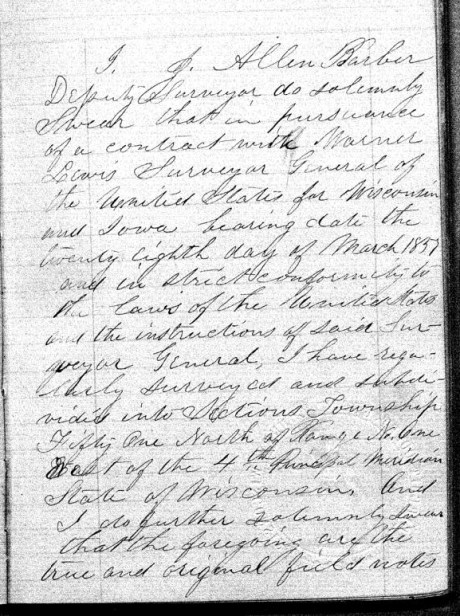
Township 51 North, Range 1 West
Barber, J. Allen
Apr. 1857
Notebook ID: INT010W04

Barber’s survey of T51N R1W included Michigan Island, Gull Island, and a corner of “Presque Island” (Stockton Island).
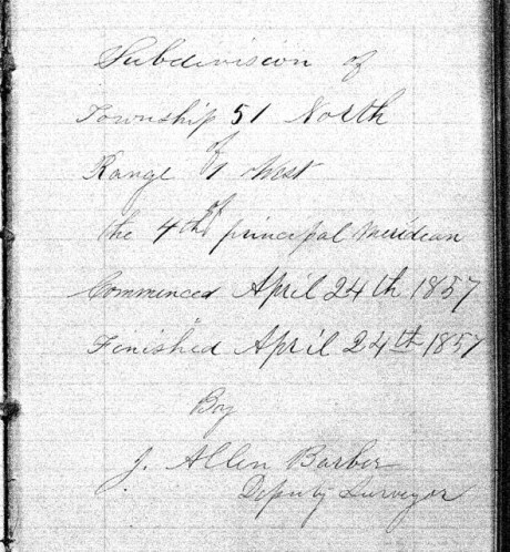
“Commenced April 24th, 1857, and finished on April 28th, 1857.”

Barber’s assistants were William W. Ward, Alexander Aiken, and Louis Nevioux.

These survey notes were sealed in Lancaster, Grant County, on July 1st, 1857. Barber’s assistants were not signatories.
Interior Field Notes
Township 52 North Range 1 West
Barber, J. Allen
Apr. 1857
Notebook ID: INT010W05
Barber’s survey of T52N R1W included the northeastern end of “Presque Island” (Stockton Island) and the south western end of Outer Island.

“Commenced March 28th, 1857. Finished March 31st, 1857.”

Barber’s assistants were William W Ward, Alexander Aiken, and Louis Nevioux.
These survey notes were sealed in Lancaster, Grant County, on July 1st, 1857. Barber’s assistants were not signatories.
Interior Field Notes
Township 53 North Range 1 West
Barber, J. Allen
Apr. 1857
Notebook ID: INT010W06

Barber’s survey of T53N R1W included the northwestern part of Outer Island. The rest of this township is covered by Lake Superior.

“Commenced March 29th, 1857. Finished March 30th, 1857.”

Barber’s assistants were William W Ward, Alexander Aiken, and Louis Nevioux.
These survey notes were sealed in Lancaster, Grant County, on July 1st, 1857. Barber’s assistants were not signatories.
Interior Field Notes
Township 50 North Range 2 West
Barber, J. Allen
Apr. 1857
Notebook ID: INT019W04

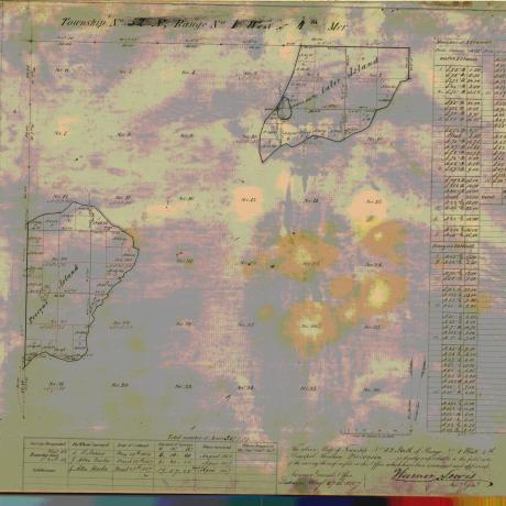
Barber’s survey of T51 R2W included part of Madeline Island.

“Commenced April 22nd, 1857. Finished April 23rd, 1857.”
Barber’s assistants were William W Ward, Alexander Aiken, and Louis Nevioux.
These survey notes were sealed in Lancaster, Grant County, on July 1st, 1857. Barber’s assistants were not signatories.
Interior Field Notes
Township 51 North Range 2 West
Barber, J. Allen
Apr. 1857
Notebook ID: INT019W02

Barber’s survey of T51N R2W included the LaPointe Indian Reservation Fishing Grounds on the north end of Madeline Island, and parts of “Wilson’s Island” (Hermit Island) and “Presque Island” (Stockton Island).

“Commenced April 17th, 1857, and finished April 23rd, 1857.”

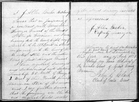
Barber’s assistants were William W Ward, Alexander Aiken, and Louis Nevioux.
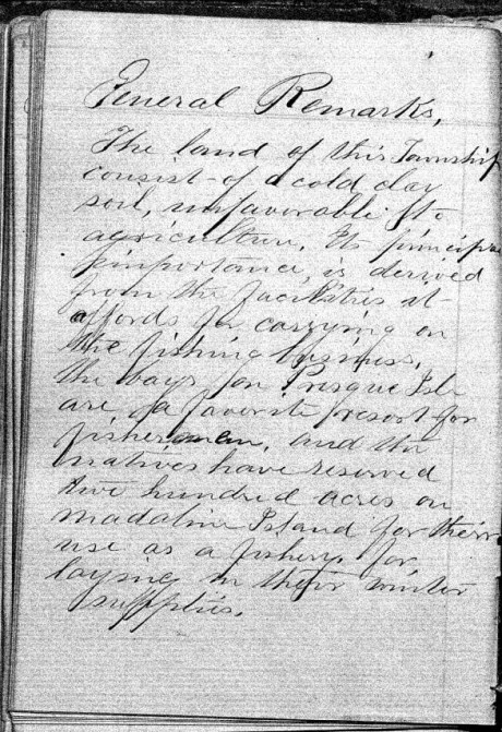
“The land of this Township consists of a cold clay soil, unfavorable to agriculture. It’s principle importance is derived from the facilities it afford for carrying on the fishing business, the bays for Presque Isle are a favorite resort for fishermen, and the natives have reserved two hundred acres on Madeline Island for their use as a fishery, for laying in their winter supplies.”


These survey notes were sealed in Bayfield on May 30th, 1857, by Samuel Stuart Vaughn as Justice of the Peace for LaPointe County. Alexander Aiken was not a signatory, yet William W Ward and Louis Nevioux (“his X mark”) were included as signatories. This nuance was not explained.

There appears to be something written or drawn behind the smaller sheet in this scan of Barber’s original survey field notes.
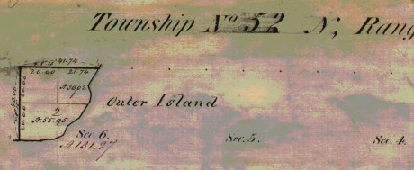
Interior Field Notes
Township 52 North Range 2 West
Barber, J. Allen
Apr. 1857
Notebook ID: INT019W03
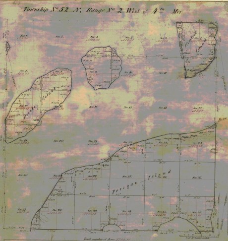
Barber’s survey of T52N R2W included “Devil’s Island” (Manitou Island), an unnamed island (Ironwood Island), and parts of “Hemlock Island” (Cat Island), and “Preque Island” (Stockton Island).
“Commenced April 1st, 1857. Finished April 25th, 1857.”

“There is but little good land in this Township, the greater part being of a very inferior quality, there is some good White Pine on Presque & Hemlock Islands.”
These survey notes were sealed in Bayfield on May 30th, 1857, by Samuel Stuart Vaughn as Justice of the Peace for LaPointe County. Alexander Aiken was not a signatory, yet William W Ward and Louis Nevioux (“his X mark”) were signatories. This nuance was not explained.
Interior Field Notes
Township 53 North Range 2 West
Barber, J. Allen
Apr. 1857
Notebook ID: INT019W05
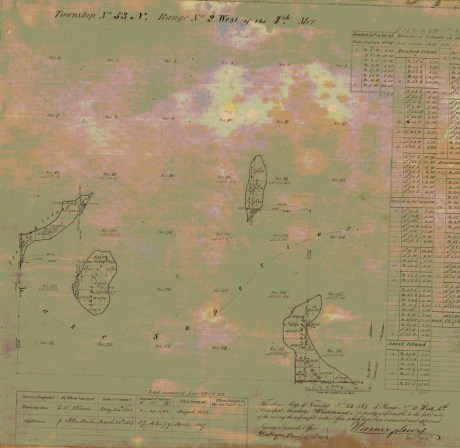
Barber’s survey of T53N R2W included “Shoal Island” (South Twin Island), an unnamed island (North Twin Island), the north end of “Hemlock Island” (Cat Island), and the east end of “Ironwood Island” (Rocky Island).

Barber’s assistants were William W Ward, Alexander Aiken, and Louis Nevioux.
These survey notes were sealed in Lancaster, Grant County on July 1st, 1857. Barber’s assistants were not signatories.
Interior Field Notes
Township 51 North Range 3 West
Barber, J. Allen
Apr. 1857
Notebook ID: INT030W06

Barber’s survey of T51N R3W included parts of “Bass Island” (Basswood Island), “Wilson’s Island” (Hermit Island), Oak Island, and the mainland where the Red Cliff Band of Lake Superior Chippewa was located six years later in 1863.

“Commenced April 14th, 1857. Finished April 28th, 1857.”

Barber’s assistants were William W Ward and Alexander Aiken, and Louis Nevieux.

“The land in this Township is all high and rolling and is pretty well adapted to agricultural pursuits, the soil is gravelly and in some places stony. The poorest portions are Wilson’s and Bass Islands, which contain more clay. Much good White Pine & Hemlock are found on the Main shore near the Lake.”

These survey notes were sealed by Samuel Stuart Vaughn at Bayfield on May 30th, 1857, by Samuel Stuart Vaughn as Justice of the Peace for LaPointe County. Alexander Aiken was not signatories.
Interior Field Notes
Township 52 North Range 3 West
Barber, J. Allen
Apr. 1857
Notebook ID: INT030W07
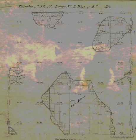
Barber’s survey of T52N R3W included parts of Oak Island, “Devil’s Island” (Manitou Island), Bear Island, “Cranberry Island” (Raspberry Island), an unnamed island (Otter Island), and the mainland where the Red Cliff Band of Lake Superior Chippewa were located six years later in 1863.

“Commenced April 4th, 1857. Finished April 29th, 1857.”
Barber’s assistants were William W Ward, and Louis Nevioux. Alexander Aiken is not identified as an assistant in this survey.

“The principal part of the land of this Township is of good quality. Oak & Bear Islands are very high and rolling with a good soil. The Island in the N.E. part of the Township is more level, but it soil is of a good quality.”

These survey notes were sealed by Samuel Stuart Vaughn in Bayfield on May 30th, 1857, as Justice of Peace for LaPointe County.
Interior Field Notes
Township 53 North Range 3 West
Barber, J. Allen
Apr. 1857
Notebook ID: INT030W08

Barber’s survey of T53N R3W included an unnamed island (Devils Island), the west end of “Ironwood Island” (Rocky Island), and the north end of Bear Island.

“Commenced Apr 4th, 1857. Finished Apr. 7th, 1857.”
Barber’s assistants were William W Ward, Alexander Aiken, and Louis Nevioux.
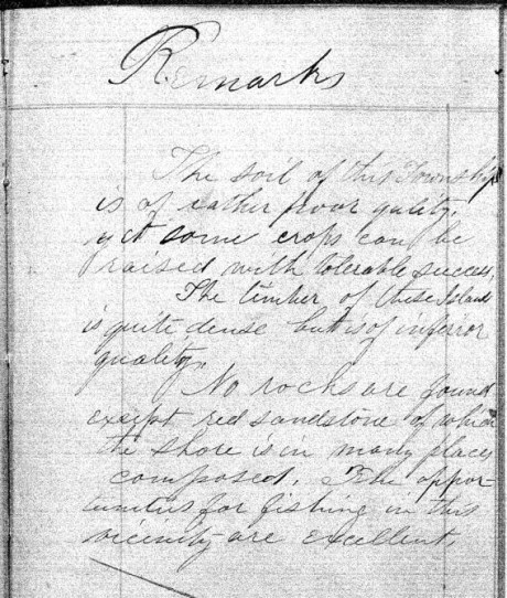
“The soil of this Township is of rather poor quality, yet some crops can be raised with tolerable success. The timber of these Islands is quite dense but is of inferior quality. No rocks are found except red sandstone of which the shore is in many places composed. The opportunities for fishing in this vicinity are excellent.”

These survey notes were sealed in Lancaster, Grant County on July 1st, 1857. Barber’s assistants were not signatories.
Interior Field Notes
Township 51 North Range 4 West
Barber, J. Allen
Apr. 1857
Notebook ID: INT040W04

Barber’s survey of T51N R4W on the mainland was used to locate the Red Cliff Reservation years later in 1863

“Commenced April 30th, 1857. Finished May 8th, 1857.”

Barber’s assistants were William W Ward, Alexander Aiken, and Loius Nevioux.
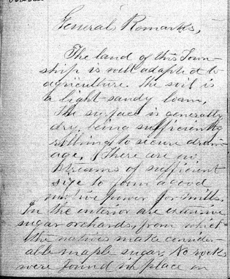
“The land of this Township is well adapted to agriculture. The soil is a light-sandy loam. The surface is generally dry, being sufficiently rolling to secure drainage. There are no streams of sufficient size to power a good motive power for mills. In the interior are extensive sugar orchards, from which the natives make considerable maple sugar. No wells were found in place in …”

“… this Township, but it belongs to the sand-stone formation and is overlaid by drift,- in some places to the depth of several hundred feet. No houses or other improvements were noticed.”


These survey notes were sealed in Bayfield on May 30th, 1857, by Samuel Stuart Vaughn as Justice of Peace for LaPointe County. Alexander Aiken was not a signatory, yet William W Ward and Louis Nevioux (“his X mark”) were signatories. This nuance was not explained.
Interior Field Notes
Township 52 North Range 4 West
Barber, J. Allen
Apr. 1857
Notebook ID: INT040W05

Barber’s survey of T52N R4W included Point Detour on the mainland, an unnamed island (York Island), the west end of “Cranberry Island” (Raspberry Island), and the east end of “Sand River Island” (Sand Island).

“Commenced April 8th, 1857. Finished April 12th, 1857.”
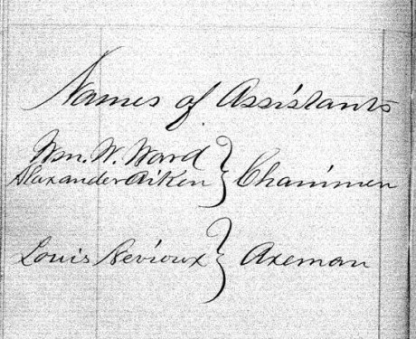
Barber’s assistants were William W Ward, Alexander Aiken, and Louis Nevioux.
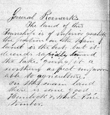
“The land of this Township is of inferior quality, the portion on the main land is the best, but it descends rapidly toward the lake, giving it a northern aspect – unfavorable to agriculture. On the main land there is some good Hemlock & White Pine timber.”


This survey contract was at Bayfield on May 30th, 1857, by Samuel Stuart Vaughn as Justice of Peace for LaPointe County. Alexander Aiken was not a signatory, yet William W Ward and Louis Nevioux (“his X mark”) were signatories. This nuance was not explained.
Interior Field Notes
Township 52 North Range 5 West
Barber, J. Allen
Apr. 1857
Notebook ID: INT050W04

Barber’s survey of T52N R5W included “Steamboat Island” (Eagle Island), “Little Steamboat Island” (no longer exists), and most of Sand Island.
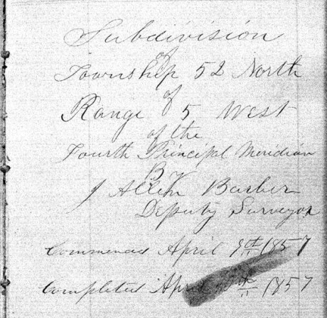
“Commenced April 8th, 1857. Finished April 10th, 1857.”

Barber’s assistants were William W Ward, Alexander Aiken, and Louis Nevioux.
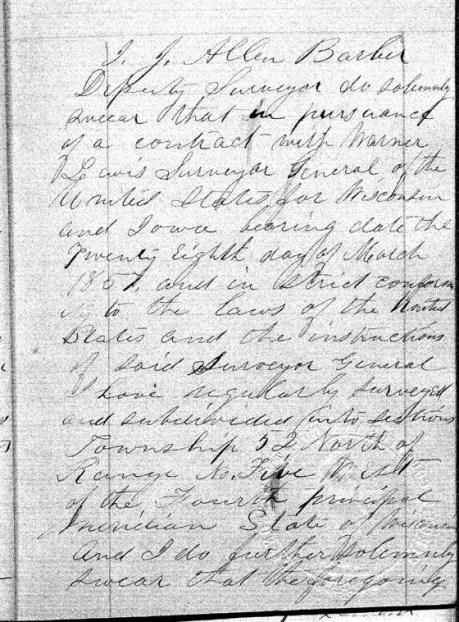
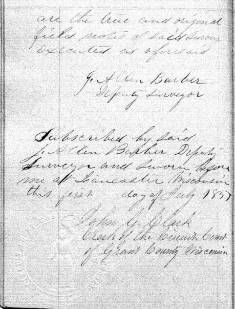
These survey notes were sealed in Lancaster, Grant County on July 1st, 1857. Barber’s assistants were not signatories.
Bayfield Mercury, August 22, 1857.
IRONTON
The Barbers did business with William Herbert and others at Ironton. The activities of “the company“ during the Summer of 1857 are detailed the Penokee Survey Incidents.
“… Wm. Herbutt, was here in 1847-48 prospecting for copper for the American Fur Company.”
Report of the City Statistician, Volume 1, page 58.
Week before last we took a trip to Ironton and the interior in company with Mr. HERBERT, the Agent of the town, and several others, and promised to give our readers an account of the the town and country back of it, but inasmuch as some kind friend took the liberty of abstracting our memorandum book from our pocket, we cannot give as definite an account as we would like.

Lake Superior surveyor, American geologist, and Harvard University professor Josiah Dwight Whitney. ~ Portrait of Whitney by Silas Selleck, 1863.
Ironton is situated on the South shore about 20 miles from this place and three fourths of a mile from the mouth of the Montreal river, which is the State line between this State and Michigan. Its harbor is good and the water is of sufficient depth for any of the largest class of steamers. The company are building a splended pier, 400 feet long, and when finished it probably will be one of the most substantial piers on the Lake, and will cost about $5000. They have also erected a large Hotel, two stories high, and we also noticed the materials on the ground for putting up several frame buildings, and arrangemnts has been made for the erection of a steam sawmill with 40 horse power, which is to be completed this summer, and will cost from $10,000 to $12,000. The lots are 40 x 125, except on 1st and 2nd streets which are 40 x 128.
The site of the town is beautiful, — about a third of it is on a nice level next to the Lake, and then it ascends gradually in benches back for one or two miles. Its near proximity to the Copper mines on the Montreal river and the Iron range back, together with the farming lands, which by the bye is not equalled on Lake Superior, must needs make Ironton a town of no small importance. The company are cutting out a good road from Ironton to the Iron range some 16 miles in length.
While there we visited the Falls on the Montreal river, the scenery of which cannot be surpassed on the Lakes. The lower falls are 60 feet high and the upper falls are 80 feet. They are about three miles apart. The indication of mineral between the two falls and especially on Mr. WHITNEY’s claim, bids as fair for large deposits of copper as any that has yet been discovered and certainly has a good surface show as had any of the mines that are now being developed.
We could say much more about the Iron range and surrounding country, but defer it until another time. The town was only laid out in February last, and it already bids fair for a bright future. Go on gentlemen, we hope you will build up a large town, and help develop the vast resources of the Great Northwest, and we will aid you what we can.
Lancaster Aug 30th 1857
Dear Son.
Maria Green Barber. She came to Lancaster to visit her in-laws, and to consider relocating there from Vermont.
A week or more since I rec’d a letter from [you?] at Bayfield by [????] I am happy a safe arrival for which I am very thankful. But in it you don’t say where your father is. [??? ???ably] return or whether he intends to come here, or go home, or other ways expecting me to go along [???? ?? ?? ????? ????] I have not had a letter from him since you left but father Barber goes on some other which road. I have not [?????] to [????????] as [????????????] about [?? ???] there to get it. Mr Burr [??????] last [??? ???] – I did not know what to do about going but as the friends here so I Pray [??? ???] he would come this way to see to his produce [????????] was out state with [???] that time I thought but to wait a little longer. [?? ??? ????] an [????] I wished I would stay with this while [?? ??? ???] as they are rather homesick [???] the [???? ??? ??? ??? ????? ??????] [????? ??? ??????] I enjoy myself better with them than of [???? other affect?] as it is such a pleasant family and very young so comfortable quilt – Last evening the Bank came up here to give me a seranade. They had intended to come [???] and were expected and They were invited in and treated to Coffee, pie, and cake and the girls gave them the best music – as they said – on the Piano they ever heard – Then they all joined in several songs They went to nearly every house in the town “to wake them up.” Yesterday Miss Barber got in another exhibition – that is, had them (her exhibit) & had something to speak – had a stage in [??????] grove where they exhibited had a pre-mer. I tried to get some – singing – pretty much failed in that – tried to get out there hard and wholely failed – and on the whole, not “[????? ???????]” they say.
It is quite [??????] here [????????? ???? ????] several others of summer complained. There has been hot months but, [???? ?????? ???? ????? ????? ?????] Esq [M????] wife are considered [????? ??? ????]
I wish I knew what [???? ? ??? ???? ????] as your father would write [??????? ??????? ????? ??? ???] to go home without [???????] at last. Got a line from [Albe?] last week. Suppose he [????] to as he does not [?????] to [???????????????????] but “lying ‘round longer.” [??? ??] very sorry he was not that [winter?] the government and instruction of some one who would have taught him something useful and kept in a study.
It is beautiful weather now for gathering the grain [????? ???? ????? ????????? ????] will be plenty of them but very little fruit of any kind this year.
I expect father will come this week without fail if he comes at all. Have heard nothing more about going to Cassville. Uncle Allen is building a large office and Cyrus and Thode are building the Evert house fence. Write often, till you come, to your
Mother
Johnson Sept 20 /57
Friend Allen
May I call you friend? I will venture for if I recollect right we were once very good friends and I hope that we are so still although we are far distant from each other, and may never meet again in this world, have you forgotten Hattie? I have not forgotten Allen and probably never shall, and were I even disposed I have a small gillon badge laid safely away which brings forcably to my mind an old friend who much resembles you, when I once knew. Amherst said he presumed you would not think I was very naughty to dare to write to you, so I thought I would take the liberty. I have written enough so I will close by saying please don’t forget the Johnson people for we shall never forget you.
Good night
Hattie C.
P.S.
Beware of those pretty squaws out there.
Allen,
I want you to understand that Miss Hattie & Miss Hastings & Carls & I have spent the evening here together at Mr. Caldwells upstairs & have had all sorts of good times. That is, as far as I am concerned. (I do not speak for the ladies) & I have enjoyed myself “excruciatingly” (as Hattie suggests) considering the company & the advantages I had.
That’s all
Am
Lancaster Sept 20th 1857
Dear Son.

Portrait of George Riley Stuntz. ~ The Eye of the North-west: First Annual Report of the Statistican of Superior, Wisconsin by Frank Abial Flower, 1890, page 26.
I will venture to write once more to you tho I have no evidence that my letters ever reach you. I have had two letters from you but not one from father since you left here. One from him to Mr Burr of Sept 15-6th appears to be the only one he has sent here since you arrival. Why he has not written to me to let me know what to do about going home I cannot understand, but here I am yet, and shall stay, until he either comes or writes he is not coming. I should have written several times to him, had I not expected him every week [??????????] letter [????] that you had not [??????] from [???????] I had not gone home with Mr B. Mr Stunts [visited?] here, and said he was going [??????] to La Pointe [???? ??????] you have learned the state of affairs before this. Mr [??] returned home last night having been about now a few weeks, had a fortunate trip tho on Lake Ontario there was a high wind and every passenger very sick. I am thankful to have escaped that, but something else may happen to us when I do go. Oh how I do dread the journeys.
I am confident that your father will be here this week, that is if he is not still too sick to come – which I greatly fear he is. If he is still there when this arrives he may [c??????] it as much to him as to you. How I wish you would confide to travel there this fall and to remain with [me?] [?????] to me the [??????????] and remain there this winter [?????????????????????????????????????????????????????]
There will be a County Fair held here this week – the grounds in full view of Uncle Jay’s where I am now stopping. I shall probably see some of the best food [ration?] of this great country. I went, two weeks since to McCartney and Cassville with Allen and family. Had a pleasant ride, but it was very warm and dusty. Mc has a beautiful place, the largest orchard in the county, I suppose, as they will have 500 bushels this fall. It is on the highest land 2 miles east of the Miss. river. But perhaps you have been there, if not you have seen the river at other points. I was wishing to see the “great river” and went to Cassville for that purpose. It is certainly worth the trouble of going to see. Aunt Sa’h pointed out to me a high sharp bluff which Augustus climbed and left his name out on the white bark of a [tree?]. To me, how interesting – almost sacred does every thing appear where he has left the impress of his work. There is nothing can bring so forcibly to our minds a dear departed friend, as a sight of the productions of his hands or his mind. So, if we would be remembered with pleasure and gratitude we must do something for the good of every being with whom we have to do.
“IN MEMORY OF
AUGUSTUS H. BARBER
of Cambridge, Vt. U.S. Deputy Surveyor
who was drowned in
Montreal River
Apr. 22. A.D. 1856
Aged 24 yrs. & 8 ms.”
~ FindAGrave.com
I hope your father has placed the marble he sent me enclosed the grave of the dear one who lies on the land here, I feared shall never have the melancholy satisfaction of visiting the cursed spot. It hardly know whether I can wish to behold the terrible scene where he lost his prime life. I cannot but fear that those of my family now in that inhospitable shore may be laid beside that line [??] bed grave that we may all live to [???? ???? ?????].
And land flowing with milk and sugar – than which no better can be found, at least I have yet found a place better adapted in all respects to make life comfortable. With labor and care we can have all that is desirable there – without those we can h should have little enjoyment here unless we are content to live in poverty and filth. One thing alone would discourage me from coming to this Western world, where in the great uncertainty or procuring a constant convenient supply of good soft water. Here, at Jay’s, their Cistern leaks and they have to fix up the pump and have to draw it from the bottom where it [????? ?? ???] with a pail and string, as they do at Allen’s and Thode’s you know there is no cistern and they manage to catch some in tubs to wash with.
It would almost kill Marth and the girls to bring enough from the spring near as it is, based on when they get it, it is good for nothing to wash with in that it is cleansed with [??? ?? ???]. I never yet saw water so convenient, plenty and good as it is at our old home.
Mr. Harris [?????] died about 3 weeks since, and Mrs. Mills is not expected to live but a few days – perhaps hours. It has been very healthy most of the [senses?] People from other places come here to spent the summer on account of the known healthfulness of the place. One gentleman from Cleveland, with consumption, and the Drs said, come – at the end of the 1 week, he had gained 12 lbs – Says he will buy property and stay here. [Sherman Page?] is here – has commenced a select school.
I have no more to [??????????????????????????]
your Mother
Aunt Lucy is unwell to day and I have [????] the [?????].
All friends well but Allen who has his old complaint.
Am sorry this ink is not black & you can read it.
To be continued in the Fall of 1857…
CAUTION: This translation was made using Google Translate by someone who neither speaks nor reads German. It should not be considered accurate by scholarly standards.
When we last left Moritz Wagner and Carl Scherzer, the two Austrian adventurers who traveled across Lake Superior in 1852, they had avoided certain death when caught in a storm halfway through the crossing between Bad River and La Pointe. In this post, we find them on Madeline Island in the wee hours of the morning, looking for a place to stay.
In the three days they spent in La Pointe, they produced a description of the island as colorful as any I’ve come across. Enjoy:

A View of La Pointe from Report of a Geological Survey of Wisconsin, Iowas, and Minnesota (1852) by David Dale Owen (Digitized by Google Books)
XXI
From Ontonagon to the mouth of the Bois-brule River–Canoe ride to Magdalen Island–Porcupine Mountains–Camping in the open air–A dangerous canoe landing at night–A hospitable Jewish family–The island of La Pointe–The American Fur Company–The voyageurs or courriers de bois–Old Buffalo, the 90 year-old Chippewa chief–A schoolhouse and an examination–The Austrian Franciscan monk–Sunday mass and reflections on the Catholic missions–Continuing the journey by sail–Nous sommes degrades–A canoeman and apostle of temperance–Fond du lac–Sauvons-nous!
It was 1 o’clock in the morning, and the whole settlement was in a deep sleep. We were at a loss as to which door to knock at. Among 200 Indians, only a few white families live there. One of the boatmen gave us a name, with which we found Mr. Austrian (a name meaning Oestreicher) a descendent of the Mosaic.
We knocked confidently by rattling at the window showing the distinguishing hemp of Austrian. We have always had a favorable bias for our Jewish countrymen in this nation. They have brought over so many ancient patriarchal customs of antiquity unadulterated, faithful, and pure in their sympathetic breasts. Here the noble manners of hospitality sweep away the cold breath of selfishness found among the Americans. The Jews are always ready to welcome strangers and donate a warm and magnanimous hand with every occasion.
They opened and the young doorman yelled out to the person in the next room, “Joe, steh auf, Leut from below, sind da!” and because it could not be doubted that we were, “One of our people!” We were then bombarded with all the tastes of the kosher delicatessen: belek, kugel, kindeln, and other tidbits of the Jewish frying pan. We were offered a nice, clean room and did not suspect that the close Yom Kippur (Jewish fast day) should frustrate our feast.
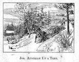
Jewish-immigrant brothers, Julius and Joseph Austrian, were prominent La Pointe residents at this time. This image depicts an incident from Benjamin Armstrong’s Early Life Among the Indians (Engraving by Marr & Richards Co.).
17 September, early, 61° Fahr. The actual owner of the home was absent. However, his younger brother received us with all the warmth of a Bayreuth Jew. He had only been in the country a short time, and spoke English with a Spanish-sounding accent as he called to us in the room, “Waken sie!” He showed us a pair of Indian snowshoes, and asked, “Haben sie snow shoes noch nie geused?*” He finally told of the fish trade in the same mixed gibberish, “Below werden die Fische umgepakt, inspected, und dann weider vereignepakt again.”
(*German immigrants all have a peculiar manner of acquiring the English language. As they hear a strange new name, they mix it together immediately with the words of their native language, without regard for how the expression works in English. A carpenter told us, “Wenn sie ein loghouse bauen wollen un dasselbe inwendig geplastered und von außen geclapboarded wird, so wird es 700 dollars kosten!”
In Pennsylvania, all counties speak an unintelligible German-English slang. It may be that after a few generations, a whole new language is emerging. So, some German immigrants are a tragic example of how one can forget his native language without having to learn another language as a substitute.)
La Pointe is the largest of several islands known under the collective name of Isles des Apotres. It has an unusual history. One of the earliest points on Lake Superior where men of faith planted the cross of salvation in 1665, it wasn’t until a century later that the progress of civilization began to push the two and four-legged forest dwellers further and further west . For several years it was the home depot (post) of the Fur Trading Company. This trading company was founded in 1808 by John Jacob Astor as the American Fur Trading Company, by an act of law of the State of New York. It granted exclusive right of trade and intercourse with the Indians, and in earlier times, provided an immense source of power and wealth. Currently, the business is divided between a Company of the West and the North West, of which the latter united with the Hudson’s Bay Company* and created unrestricted competition and limited the field of activity. The company of the west, currently under the leadership of J. Chouteau and Company, trades with the Indians of the Missouri and Mississippi. Its headquarters are at the upper Mississippi. The company owns 25 stations (trading posts) employing 200 voyageurs who take care of transporting commodities in the business season and bring the furs to the businesses located in St. Paul, Mendota, and Crow Wing in the Minnesota Territory.
(*[This footnote goes on for several pages on the history and structure of the Hudson Bay Company. As it interrupts the narrative, and can be found in other sources, I’ve omitted it.])
The different Indian tribes will kill the animals of the forest in the course of the year and then gather at certain points for the individual bands. Every year there is a caravan of agents (traders) of the fur company who obtain this rich quantity of valuable animal skins from the ignorant Indians for a lowly price of trade items.
This commercial agent will bring birch canoes full of presents across Lake Superior, and usually in 26 to 30 days will bring back the skins of bears, wolves, silver and other foxes, beavers, raccoon, martens, wolverine, otters, muskrats, weasels, and buffalos. Whether their fate is to be a winter covering for the delicate lady’s hands or the lining of a skirt in the princely salons is yet to be determined.
Next door, in perhaps richer numbers and selection, but certainly of far less value, are items of the clever broker. The eyes glare as he flaunts his manufactures. One sees, woolen blankets, cloth fabrics, firearms, ammunition, tin kettles, earrings, finger rings, brass buttons, breastplates, wampum, chopping knives, birch canoes, and mirrors. There is makeup of red, blue, black, and green color, but all the items together carry only one color, that of speculation and dizzying purpose.
Although the furs are barter items, they have an adopted value determined so that the price of the animal fur always corresponds with a certain number of exchanged wares. But the furs are usually valued very low and in contrast, the reverse items are priced very high. The total traffic area with the Indians in the West should produce 1 million dollars annually. Together, the furs are shipped, via New York, to London which is the main market for the American fur trade.
Since we did not visit these remote areas during the season of barter, we could not bear witness to this certainly most-interesting and instructive spectacle, but we cannot omit some words and impart some pressure as we become aware of the facts which throw a sad light on the business of the whites with the Indians. We believe it is the same, and more truthful, to be told as it is by Schoolcraft, the highly-respected American historian, on his travels among the tribes on Lake Superior.
A shotgun worth 10 guineas was sold by an agent to an Indian chief for 120 pounds of beaver skins, or 480 dollars of value. A caravan of 6 bales of barter commodities was traded for $2000. In Athabasca, 96 sacks of beaver skins weighing 8640 pounds brought back four dollars of value when their real worth was $34,560!
Another scholarly researcher, Coldon,writing in 1741 in the area of the Five Nations, describes how the whites in general and the traders in particular, create debts. The vice of drunkenness among the wild Indians occurs so frequently because the greed of the traders allows them to shrink to the lowest means and intentionally put the foolish aborigines in a state of intoxication causing an even more advantageous position for fraud. This evil passion has wreaked more havoc among the Indians than disease or war. It has destroyed more than instruction in Christianity could ever be capable of building up.
Among the Indian tribes there is a strongly-held opinion that if you murder a fur trader, he will retaliate by intentionally bringing back infected goods.* This belief probably arose from the sensitivity caused by the way the whiteskins associate with the redskins. They treat the actual natives of American soil as their subjects and servants, and consider it their privilege to satisfy their greed and passion and claim material and bodily impunity.**
(*[Here the authors insert an extensive footnote about smallpox infections in the Lake Superior region. As it disrupts the narrative and is information that can be found in Schoolcraft’s Narrative of an Expedition Through the Upper Mississippi River to Itasca Lake, I’ve omitted it here.])
(**Two residents of La Pointe told us how a former agent convinced several Indians and mix-bloods to entrust him with their savings due to them from the sale of the Indian country to the government. He used the advantage of his position to gain their trust and did not issue receipts for the borrowed. He had about $800 from everyone but when it was claimed, the fraudulent agent told them they would have to be content with repayment in commodities, flour, sausage, and potatoes, for which the he charged an exorbitant price. We started this narrative not wanting to believe it, but two good Catholics swore on the host. The agent has since left this island, to general contempt, taking the gold pieces of the Indians with him.)

The Voyageurs (1846) by Charles Deas (Wikimedia Images)
After this discussion of the of the rates of the American Fur Company and its agents, we want to add some details about the men whose labor and time exerted such a great influence on the fate and culture of the Indian tribes. We wish to add a few explanatory words about the sad presence on La Pointe of the voyageurs or courriers du bois.
This peculiar class of people, which is like a vein of metal that suddenly disappears within the bedrock and reappears many hundreds of miles away under the same geological conditions, their light reaches the borders of the eastern Canadas. The British people, with their religion and customs, reappeared on the shores of these northern lakes only in 1808 with the Fur Company. For labor they drew on those who could carry their wares across the lakes and communicate with the Indians.
Many young men of adventurous natures left the old wide streets of Montreal and moved into the trackless primeval forests of the West. Young and strong as laborers, they soon started to adopt the lifestyle and language of the aborigines. They married with the Indians and inhabit small settlements scattered throughout those mighty lands which begin at Mackinow Island and come up the upper lake to the region of Minnesota. They almost all speak the Canadian patois along with the language of the Chippewas, the tribe with which they came into kinship. We found only a few, even among the younger generation, who understood English.
Since then, every day the population of the otherwise deserted shore of Lake Superior increases with the discovery of copper mines. The animals driven away by the whirlwind of civilization toward the west, attract the Indians with their sensitive guns, leaving La Pointe, abandoned by the Company for their headquarters at St. Paul in Minnesota. Most voyageurs left the island, having seen their business in ruins and lacking their former importance. Just a few families remain here, making a meager livelihood of hunting, fishing, and the occasional convoy of a few travelers led by business, science, or love of nature who purchase their limited resources.*
(*Except for us, this year they had only two travelers visit this area for scientific interest. The scarcity of this type of tourist seems to be the reason why the price the voyageurs and their companions ask is high. We paid all our leaders one and one half dollars a day and just as many for the days necessary for their return. The voyageurs are democratic and truly similar to those Alpine villagers who charged the emperor two Louis d’or for a breakfast of two eggs.)
A devout Franciscan friar, the family of a Methodist preacher, a school teacher, and a skilled tradesman, together with some old canoe houses, remains of the once large voyageur legion, make up the small numbers of the white population.
The island is 15 miles long, 5.6 miles wide, and has 30 miles in circumference. The main formation is sandstone and red clay. Vegetation proliferates in spruce, pine, cedar, birch, tamarack (Larix americana), etc. The oval horseshoe shape of the island makes it one of the best ports of the entirety of Lake Superior, and this, despite current unemployment, promises hope for a comfortable future.
Add to that, the infinite abundance of fish on their shores. Delicious, but only edible in the spring, are the Siscawit (Salmo siscowet), and the trout (Salmo amethystus). The whitefish (Coregonus albus) are available in uncommon quantities. The most successful fishmonger here sent during the past years, 300 barrels of various species of fish, each 200 pounds, to the markets of Cleveland and Detroit.

The Siscowet, or Fat Trout, is a subspecies of Lake Trout (Drawn by David Starr Jordan, and Barton Warren Evermann, 1911; Digitized by University of Washington)
At the invitation of the zealous schoolteacher*, we toured the schoolhouse. Here we met Old Buffalo (Chi Waishki or Pezhickee), the 90-year-old hereditary chief of the Chippewa band. He was wrapped in a blue striped shirt and a wool blanket. He carried a royal scepter made from a broken wooden base of a bed as a symbol of his authority. He was looking for some glue to repair a garment for a young Indian. We find it necessary here to mention that of the many Chippewas on this island, very few are full-blood Indians. Having crossed frequently with the European race, and through the efforts of Christian missionaries, they have adopted the habits of civilization. They inhabit the abandoned wooden shacks of the Fur Company, and are even given to industrial employment.
(*Mr. Pulcifer, the schoolmaster is a highly-educated teacher. He gives the Sabbath service in the absence of the Methodist preacher. The Methodist mission on the island of La Pointe was founded in 1831).
The Indian chief, worthy by his age, heredity, and his imposing figure, told us he was born near the island and left the area only once to travel in the matters of his tribe to the Great Father* in Washington. His stay was accompanied by many consoling words but little actual success. Since then, he’s been back to the chase. One winter, he brought in 150 fox skins. Despite this wealth of skins in a game-rich area, he is now poor. Here we have the hereditary Chippewa chief, whose generations (totem) are carved in the ancient birch bark,** giving us profuse thanks for just a modest silver coin and a piece of dry cloth. What time can bring to a ruler!
(*”Great Father” is what the Indians call the President and other agents of the United States government.)
(**Almost all Indian tribes have the custom of preserving their lineage from oblivion by carving characters, that correspond to the names of their tribe, on trees, canoes, weapons and everywhere else.
Strangely, we later learned that the majestic Old Buffalo was violently opposed for years to the education and spiritual progress of the Indians. Probably, it’s because he suspected a better instructed generation would no longer obey. Presently, he tacitly accepts the existence of the school and even visits sometimes, where like ourselves, he has the opportunity to see the gains made in this school with its stubborn, fastidious look of an old German high council.)
Although made of simple planks, the school hall is clean and well-ventilated. The youth, consisting of 25 mix-blooded children, are instructed by the Methodist teachers in reading, writing, arithmetic, geography, and natural history. The teacher takes 6 to 8 children to the teacher’s desk and tells them to read their lessons or recite them from memory. Most often, there are questions which are subjected to discussion, questions that relate to the everyday world. This gives the youth the advantage of preparation for practical life.*
(*One of these practical textbooks is similar to Guide to Knowledge, a popular textbook in England: Conversations on common things by a teacher. Boston, Munroe and Francis. 1849.)
For example, a student may read a sentence in which the word “lead” occurs. This immediately gives rise to an instructive conversation about this noble metal, such as where lead is most found, what it is used for, the compounds in which it is used, etc. The youth, by learning this way about various natural phenomena, learns at the same time to know and admire the sources of a country’s wealth. It is an early and delicate way to teach the students the important parts of the geographical, physical, and political history of the country before their own history.

The front page of the Kladderadatsh, a German-languague satirical newspaper published in Berlin. Despite it’s popularity among the masses in Europe, I’m not sure the kids in La Pointe had subscriptions (Wikimedia Images).
At the conclusion of the lesson, the older children, by their own reflection but encouraged by their teacher, asked us several questions about European life: if many European children went to school, and what they learned there…
It was shamefully difficult answering these simple questions asked by the children.
We told these smart young half-Indians that here in Europe the same God lives and moves as in their hemisphere, and that His sun is the only true light that rises for the peoples of the East. We replied further that children learn a tremendous amount but usually know incredibly little, and finally, that the Berliner Kladderadatsch is the most widely read political journal. This last answer left the little indigene who asked the pointed questions bewildered and seemed to discourage the asking of any further information about Europe. At that point, the school meeting was cancelled to our great relief.
Another no-less worthy host received us with warm greetings of the heart. It was the worthy Franciscan monk, Father Scolla, from Rudolphswerth in Carinthia. We went to deliver the pleasure of a recommendation to our pious countryman. We knocked at the meager gate of the little boarded house that grew out from the rear part of the church. We are now almost ashamed of the worldly manner in which we approached, given the distinguished reception we received at the hands of such a pious priest.

Alternate translation of this passage found in History of the diocese of Sault Ste, Marie and Marquette (1906) by Antoine Ivan Rezek pg.367 (Digitized by Google Books)
Our traveling way of life often finds us witness to scenes of parting, separation, and reunion, but we have never seen any man become so pale, taken, and overcome with intimate emotion as this Franciscan when he learned through language and handshake that we were compatriots from the Imperial City.
We can reasonably account for this surprise in that almost 20 years had passed since the lone missionary had seen a countryman “of the Imperial City” and had been addressed in his language, and felt the warm shake of an Austrian hand. His whole religious intercourse with the faithful, be it preaching the gospel at the pulpit, forgiving sin in confessional, or donating food for the journey to the deathbed, happens in a foreign tongue, in French and Indian language.
What troubled us most about his monastic life was the poverty and helplessness with which this devout priest remains continually fights to preach the Way. The greater part of his church consists of converted Indians and mix-bloods, who all live in such poor circumstances that there is no thought of support for this priest. The maintenance costs for the church and its priests must therefore be restricted to those means which fall from the general missionary funds of the Catholic Church.
The quota, that makes its way to the Church of Our Lady of La Pointe, is extremely low, and sometimes isn’t received for so many years that one gets the impression that the bishop in Milwaukee has forgotten the lonely forests of Madeline Island, its Lady, and Father Scolla. The pious Franciscan, whose destitution has denied him any assistance in church and house, must therefore do as priests and lay ministers do. He decorates and adorns the high altar, paints the images of saints, rings the bell, and worries about the upkeep of his small house at the same time.

cntd. translation in Rezek pg.368
On the Sunday before we left, we attended the service. The small church was quite filled with Indian women, mix-bloods, and Canadian voyageurs. The women wore long cloth of dark green, blue, and black covering them from hips to head and wrapping them in one whole soft shape. The men were all dressed in European clothing. During the vicarious sacrifice of the mass, four half-Indians in white surplices sang the Latin text shouldering such edification that you would have sworn they understood every word.
The sermon was held in French, the most common language of the island, and it was appropriate for the comprehension of the people in the audience. In the afternoon, the tireless Franciscan monk preaches in Indian for his neophytes, which prevents age from weakening his intellectual ability to learn a foreign tongue.
Much more edification of the faithful would have prevailed if not for the wailing cries of the infants disturbed by the devotion, who were brought along on the backs of the countless “squaws.” But these grumpy little citizens of the world seemed to understand even less than the adult choir of the plot of the Latin score.

Fr. Otto Skolla was from Novo Mesto (Rudolfswert) in today’s Slovenia not far from the Slovenian homeland of his fellow Lake Superior priest, Bishop Frederick Baraga (Rezek pg. 360)
When we speak of the conviction in his calling and pure enthusiasm of the priest’s benediction, of the faithful community dropping to their knees, covering their faces, and reverently making the sign of the cross, we could not help but feel sadness that such a worthy and pious work could not flourish better due to a lack of temporal goods.
What ability to spread blessings the Catholic missionary would have if equipped with the necessary material resources: a teacher for the youth, a doctor for the sick, a support for the poor. How can the Church win over humanity when right now the distressing spectacle is such that the Catholic youth, lacking the funds for a teacher, get no education, and the narrow-minded principles of their spiritual board keep them from getting permission to attend the Methodist school?
If you watch the incredible speed of the other religious sects, such as the Methodists, Baptists, and Presbyterians, and the extraordinary sums taken in and put out for education and missionary purposes– they have missionaries in all ports in the Union–and how without consideration of their religion, they receive immigrants, comfort the sick, the suffering, and take care of the children, while the Herald of Catholic teaching to foreign lands moves slowly. It may not surprise you, especially here in the United States that foreign religious sects are gaining converts while the ranks of the Catholic Church, despite the massive influx of Catholic populations from Ireland and Germany, not only aren’t increasing, but are actually seeing a decrease in numbers.

The Catholic church on Madeline Island as drawn by Skolla (Rezek pg.361).
CAUTION: This translation was made using Google Translate by someone who neither speaks nor reads German. It should not be considered accurate by scholarly standards.
CAUTION: This translation was made using Google Translate by someone who neither speaks nor reads German. It should not be considered accurate by scholarly standards.

Moritz Wagner (1813-1887) (Wikimedia Images)
Americans love travelogues. From de Tocqueville’s Democracy in America, to Twain’s Roughing It, to Steinbeck’s Travels with Charley, a few pages of a well-written travelogue by a random interloper can often help a reader picture a distant society more clearly than volumes of documents produced by actual members of the community. And while travel writers often misinterpret what they see, their works remain popular long into the future. When you think about it, this isn’t surprising. The genre is built on helping unfamiliar readers interpret a place that is different, whether by space or time, from the one they inhabit. The travel writer explains everything in a nice summary and doesn’t assume the reader knows the subject.
You can imagine, then, my excitement when I accidentally stumbled upon a largely-unknown and untranslated travelogue from 1852 that devotes several pages to to the greater Chequamegon region.
I was playing around on Google Books looking for variants of Chief Buffalo’s name from sources in the 1850s. Those of you who read regularly know that the 1850s were a decade of massive change in this area, and the subject of many of my posts. I was surprised to see one of the results come back in German. The passage clearly included the words Old Buffalo, Pezhickee, La Pointe, and Chippewa, but otherwise, nothing. I don’t speak any German, and I couldn’t decipher all the letters of the old German font.

Karl (Carl) Ritter von Scherzer (1821-1903) (Wikimedia Images)
The book was Reisen in Nordamerika in den Jahren 1852 und 1853 (Travels in North America in the years 1852 and 1853) by the Austrian travel writers Dr. Moritz Wagner and Dr. Carl Scherzer. These two men traveled throughout the world in the mid 19th-century and became well-known figures in Europe as writers, government officials, and scientists. In America, however, Reisen in Nordamerika never caught on. It rests in a handful of libraries, but as far as I can find, it has never been translated into English.
Chapter 21, From Ontonagon to the Mouth of the Bois-brule River, was the chapter I was most interested in. Over the course of a couple of weeks, I plugged paragraphs into Google Translate, about 50 pages worth.
Here is the result (with the caveat that it was e-translated, and I don’t actually know German). Normally I clog up my posts with analysis, but I prefer to let this one stand on its own. Enjoy:
XXI
From Ontonagon to the mouth of the Bois-brule River–Canoe ride to Magdalen Island–Porcupine Mountains–Camping in the open air–A dangerous canoe landing at night–A hospitable Jewish family–The island of La Pointe–The American Fur Company–The voyageurs or courriers de bois–Old Buffalo, the 90 year-old Chippewa chief–A schoolhouse and an examination–The Austrian Franciscan monk–Sunday mass and reflections on the Catholic missions–Continuing the journey by sail–Nous sommes degrades–A canoeman and apostle of temperance–Fond du lac–Sauvons-nous!
On September 15th, we were under a cloudless sky with the thermometer showing 37°F. In a birch canoe, we set out for Magdalene Island (La Pointe). Our intention was to drive up the great Lake Superior to its western end, then up the St. Louis and Savannah Rivers, to Sandy Lake on the eastern bank of the Mississippi River. Our crew consisted of a young Frenchman of noble birth and education and a captain of the U.S. Navy. Four French Canadians were the leaders of the canoes. Their trustworthy, cheerful, sprightly, and fearless natures carried us so bravely against the thundering waves, that they probably could have even rowed us across the river Styx.
Upon embarkation, an argument broke out between passengers and crew over the issue of overloading the boat. It was only conditioned to hold our many pieces of baggage and the provisions to be acquired along the way. However, our mercenary pilot produced several bags and packages, for which he could be well paid, by carrying them Madeline Island as freight.
Shortly after our exit, the weather hit us and a strong north wind obliged us to pull to shore and make Irish camp, after we had only covered four English miles to the Attacas (Cranberry) Rive,r one of the numerous mountain streams that pour into Lake Superior. We brought enough food from Ontonagon to provide for us for approximately 14 days of travel. The settlers of La Pointe, which is the last point on the lake where whites live, provided for themselves only scanty provisions. A heavy bag of ship’s biscuit was at the end of one canoe, and a second sack contained tea, sugar, flour, and some rice. A small basket contained our cooking and dining utensils.
The captain believed that all these supplies would be unecessary because the bush and fishing would provide us with the richest delicacies. But already in the next lunch hour, when we caught sight of no wild fowl, he said that we must prepare the rice. It was delicious with sugar. Dry wood was collected and a merry flickering fire prepared. An iron kettle hung from birch branches crossed akimbo, and the water soon boiled and evaporated. The sea air was fresh, and the sun shone brightly. The noise of the oncoming waves sounded like martial music to the unfinished ear, so we longed for the peaceful quiet lake. The shore was flat and sandy, but the main attraction of the scenery was in the gigantic forest trees and the richness of their leafy ornaments.
At a quarter to 3 o’clock, we left the bivouac as there was no more wind, and by 3 o’clock, with our camp still visible, the water became weaker and weaker and soon showed tree and cloud upon its smooth surface. We passed the Porcupine Mountains, a mountain range made of trapp geological formation. We observed that some years ago, a large number of inexperienced speculators sunk shafts and made a great number of investments in anticipation of a rich copper discovery. Now everything is destroyed and deserted and only the green arbor vitae remain on the steep trap rocks.
Our night was pretty and serene, so we went uninterrupted until 1 o’clock in the morning. Our experienced boatmen did not trust the deceptive smoothness of the lake, however, and they uttered repeated fears that storms would interrupt our trip. It happens quite often that people who travel in late autumn for pleasure or necessity from Ontonagon to Magdalene Island, 70 miles away, are by sea storms prevented from travelling that geographically-small route for as many as 6 or 8 days.
Used to the life of the Indians in the primeval forests, for whom even in places of civilization prefer the green carpet under the open sky to the soft rug and closed room, the elements could not dampen the emotion of the paddlers of the canoe or force out the pleasure of the chase.* But for Europeans, all sense of romantic adventure is gone when in such a forest for days without protection from the heavy rain and without shelter from the cold eeriness for his shivering limbs.
(*We were accompanied on our trip throughout the lakes of western Canada by half-Indians who had paternal European blood in their veins. Yet so often, a situation would allow us to spend a night inside rather than outdoors, but they always asked us to choose to Irish camp outside with the Indians, who lived at the various places. Although one spoke excellent English, and they were both drawn more to the great American race, they thought, felt, and spoke—Indian!)
It is amazing the carelessness with which the camp is set near the sparks of the crackling fire. An overwhelming calm is needed to prevent frequent accidents, or even loss of human life, from falling on the brands. As we were getting ready to continue our journey early in the morning, we found the front part of our tent riddled with a myriad of flickering sparks.
16 September (50° Fahrenheit)*) Black River, seven miles past Presque Isle. Gradually the shore area becomes rolling hills around Black River Mountain, which is about 100 feet in height. Frequently, immense masses of rock protrude along the banks and make a sudden landing impossible. This difficulty to reach shore, which can stretch for several miles long, is why a competent captain will only risk a daring canoe crossing on a fairly calm lake.
(*We checked the thermometer regularly every morning at 7 o’clock, and when travel conditions allowed it, at noon and evening.)
At Little Girl’s Point, a name linked to a romantic legend, we prepared lunch from the unfinished bread from the day before. We had rice, tea, and the remains of the bread we brought from a bakery in Ontonagon from our first days.
In the afternoon, we met at a distance a canoe with two Indians and a traveler going in an easterly direction. We got close enough to ask some short questions in telegraph style. We asked, “Where do you go? How is the water in the St. Louis and Savannah River?”
We were answered in the same brevity that they were from Crow Wing going to Ontonagon, and that the rivers were almost dried from a month-long lack of rain.
The last information was of utmost importance to us for it changed, all of a sudden, the fibers of our entire itinerary. With the state of the rivers, we would have to do most of the 300-mile long route on foot which neither the advanced season of the year, nor the sandy steppes invited. If we had been able to extend our trip, we could have visited Itasca Lake, the cradle of the Mississippi, where only a few historically-impressive researchers and travelers have passed near: Pike, Cass, Schoolcraft, Nicollet, and to our knowledge, no Austrian.
However, this was impossible considering our lack of necessary academic preparation and in consideration of the economy of our travel plan. We do not like the error, we would almost say vice, of so many travelers who rush in hasty discontent, supported by modern transport, through wonderful parts of creation without gaining any knowledge of the land’s physical history and the fate of its inhabitants.*
(*We were told here recently of such a German tourist who traveled through Mexico in only a fortnight– i.e. 6 days from Veracruz to the capital and 6 days back with only two days in the capital!)
While driving, the boatmen sang alternately. They were, for the most part, frivolous love songs and not of the least philological or ethnographic interest.
After 2 o’clock, we passed the rocks of the Montreal River. They run for about six miles with a long drag reaching up to an altitude of 100 feet. There are layers of shale and red sandstone, all of which run east to west. By weathering, they have obtained such a dyed-painting appearance, that you can see in their marbled colors something resembling a washed-out image.
The Montreal* is a major tributary of Lake Superior. About 300 steps up from where it empties into the lake, it forms a very pretty waterfall surrounded by an impressive pool. Rugged cliffs form the 80’ falls over a vertical sandstone layer and form a lovely valley. The width of the Montreal is 10’, and it also forms the border between the states of Michigan and Wisconsin.
(*Indian: Ka-wa’-si-gi-nong sepi, the white flowing falls.)
We stayed in this cute little bay for over an hour as our frail canoes had begun to take on a questionable amount of water as the result of some wicked stone wounds.
Up from Montreal River heading towards La Pointe, the earlier red sandstone formation starts again, and the rich shaded hills and rugged cliffs disappear suddenly. Around 6 o’clock, we rested for half an hour at the mouth of the Bad River of Lake Superior. We quickly prepared our evening snack as the possibility of reaching Magdalene Island that same night was still in contention.
Across from us, on the western shore of Bad River*, we saw Indians by a warm fire. One of the boatmen suspected they’d come back from catching fish, and he called in a loud voice across the river asking if they wanted to come over and sell us some. We took their response, and soon shy Indian women (squaws) appeared. Lacking a male, they dreaded to get involved in trading with Whites, and did not like the return we offered.
(*On Bad River, a Methodist Mission was founded in 1841. It consists of the missionary, his wife, and a female teacher. Their sphere of influence is limited to dispensing divine teaching only to those wandering tribes of Chippewa Indians that come here every year during the season of fishing, to divest the birch tree of its bark, and to build it into a shelter).
A part of our nightly trip was spent fantastically in blissful contemplation of the wonders above us and next to us. Night sent the cool fragrance of the forest to our lonely rocking boat, and the sky was studded with stars that sparkled through the green branches of the woods. Soon, luminous insects appeared on the tops of the trees in equally brilliant bouquets.
At 11 o’clock at night, we saw a magnificent aurora borealis, which left such a bright scent upon the dark blue sky. However, the theater soon changed scene, and a fierce south wind moved in incredibly fast. What had just been a quietly slumbering lake, as if inhabited by underwater ghosts, struck the alarm and suddenly tumultuous waves approached the boat. With the faster waves wanting to forestall the slower, a raging tumult arose resembling the dirt thrown up by great wagon wheels.
We were directly in the middle of that powerful watery surface, about one and one half miles from the mainland and from the nearest south bank of the island. It would have been of no advantage to reverse course as it required no more time to reach the island as to go back. At the outbreak of this dangerous storm, our boatmen were still determined to reach La Pointe.
But when several times the beating waves began to fill our boat from all sides with water, the situation became much more serious. As if to increase our misery, at almost the same moment a darkness concealed the sky and gloomy clouds veiled the stars and northern lights, and with them went our cheerful countenance.
Now singing, our boatmen spoke with anxious gestures and an unintelligible patois to our fellow traveler. The captain said jokingly, that they took counsel to see who should be thrown in the water first should the danger increase. We replied in a like manner that it was never our desire to be first and that we felt the captain should keep that honor. Fortunately, all our concern soon ended as we landed at La Pointe (Chegoimegon).
To be continued…
CAUTION: This translation was made using Google Translate by someone who neither speaks nor reads German. It should not be considered accurate by scholarly standards.
Chief Buffalo, Flat Mouth, and Tecumseh
April 28, 2013
 The Shawnee Prophet, Tenskwatawa painted by Charles Bird King c.1820 (Wikimedia Commons)
In contrast with other Great Lakes nations, the Lake Superior Ojibwe are often portrayed as not having had a role in the Seven Years War, Pontiac’s War, Tecumseh’s War, or the War of 1812. The Chequamegon Ojibwe are often characterized as being uniformly friendly toward whites, peacefully transitioning from the French and British to the American era. The Ojibwe leaders Buffalo of La Pointe and Flat Mouth of Leech Lake are seen as men who led their people into negotiations rather than battle with the United States.
No one tried harder to promote the idea of Ojibwe-American friendship than William W. Warren (1825-1853), the Madeline Island-born mix-blooded historian who wrote History of the Ojibway People. Warren details Ojibwe involvement in all of these late-18th and early 20th-century imperial conflicts, but then repeatedly dismisses it as solely the work of more easterly Ojibwe bands or a few rogue warriors. The reality was much more complicated.
It is true, the Lake Superior Ojibwe never entered into these wars as a single body, but the Lake Superior Ojibwe rarely did anything as a single body. Different bands, chiefs, and families pursued different policies. What is clear from digging deeper into the sources, however, is that the anti-American resistance ideologies of men like the Tecumseh and his brother Tenskwatawa (The Prophet) had more followers around here than Warren would have you believe. The passage below, from none other than Warren himself, shows that these followers included Buffalo and Flat Mouth.
History of the Ojibway People is available free online, but I’m not going to link to it. I want you to check out or buy the second edition, edited and annotated by Theresa Schenck and published by the Minnesota Historical Society in 2009. It is not the edition I first read this story in, but this post does owe a great debt to Dr. Schenck’s footnotes. Also, if you get the book, you will find the added bonus of a second account of these same events from Julia Warren Spears, William’s sister (Appendix C). The passage that is reproduced here can be read on pages 227-231.
“… no event of any importance occured on the Chippeway and Wisconsin Rivers till the year 1808, when, under the influence of the excitement which the Shaw-nee prophet, brother of Tecumseh, succeeded in raising, even to the remotest village of the Ojibways, the men of the Lac Coutereille village, pillaged the trading house of Michel Cadotte at Lac Coutereilles, while under charge of a clerk named John Baptiste Corbin. From the lips of Mons. Corbin, who is still living at Lac Coutereille, at the advanced age of seventy-six years, and who has now been fifty-six years in the Ojibway country, I have obtained a reliable account of this transaction…”
“…In the year 1808, during the summer while John B. Corbin had charge of the Lac Coutereille post, messengers, whose faces were painted black, and whose actions appeared strange, arrived at the different principal villages of the Ojibways. In solemn councils they performed certain ceremonies, and told that the Great Spirit had at last condescended to hold communion with the red race, through the medium of a Shawano prophet, and that they had been sent to impart the glad tidings.
The Shawano sent them word that the Great Spirit was about to take pity on his red children, whom he had long forsaken for their wickedness. He bade them to return to the primitive usages and customs of their ancestors, to leave off the use of everything which the evil white race had introduced among them. Even the fire-steel must be discarded, and fire made as in ages past, by the friction of two sticks. And this fire, once lighted in their principal villages, must always be kept sacred and burning. He bade them to discard the use of fire-water—to give up lying and stealing and warring with one another. He even struck at some of the roots of the Me-da-we religion, which he asserted had become permeated with many evil medicines, and had lost almost altogether its original uses and purity. He bade the medicine men to throw away their evil and poisonous medicines, and to forget the songs and ceremonies attached thereto, and he introduced new medicines and songs in their place. He prophesied that the day was nigh, when, if the red race listened to and obeyed his words, the Great Spirit would deliver them from their dependence on the whites, and prevent their being finally down-trodden and exterminated by them. The prophet invited the Ojibways to come and meet him at Detroit, where in person, he would explain to them the revelations of the “Great Master of Life.” He even claimed the power of causing the dead to arise, and come again to life.
It is astonishing how quickly this new belief obtained possession in the minds of the Ojibways. It spread like wild-fire throughout their entire country, and even reached the remotest northern hunters who had allied themselves with the Crees and Assiniboines. The strongest possible proof which can be adduced of their entire belief, is in their obeying the mandate to throw away their medicine bags, which the Indian holds most sacred and inviolate. It is said that the shores of Sha-ga-waum-ik-ong were strewed with the remains of medicine bags, which had been committed to the deep. At this place, the Ojibways collected in great numbers. Night and day, the ceremonies of the new religion were performed, till it was at last determined to go in a body to Detroit, to visit the prophet. One hundred and fifty canoes are said to have actually started from Pt. Shag-a-waum-ik-ong for this purpose, and so strong was their belief, that a dead child was brought from Lac Coutereille to be taken to the prophet for resuscitation.
This large party arrived on their foolish journey, as far as the Pictured Rocks, on Lake Superior, when, meeting with Michel Cadotte, who had been to Sault Ste. Marie for his annual outfit of goods, his influence, together with information of the real motives of the prophet in sending for them, succeeded in turning them back.
The few Ojibways who had gone to visit the prophet from the more eastern villages of the tribe, had returned home disappointed, and brought back exaggerated accounts of the suffering through hunger, which the proselytes of the prophet who had gathered at his call, were enduring, and also giving the lie to many of the attributes which he had assumed. It is said that at Detroit he would sometimes leave the camp of the Indians, and be gone, no one knew whither, for three and four days at a time. On his return he would assert that he had been to the spirit land and communed with the master of life. It was, however, soon discovered that he only went and hid himself in a hollow oak which stood behind the hill on which the most beautiful portion of Detroit City is now built. These stories became current among the Ojibways, and each succeeding year developing more fully the fraud and warlike purpose of the Shawano, the excitement gradually died away among the Ojibways, and the medicine men and chiefs who had become such ardent believers, hung their heads in shame whenever the Shawano was mentioned.

 Two men of “strong minds and unusual intelligence,” Buffalo of La Pointe (top) and Eshkibagikoonzhe or “Flat Mouth” of Leech Lake. (Wisconsin Historical Society) (Minnesota Historical Society)
At this day it is almost impossible to procure any information on this subject from the old men who are still living, who were once believers and preached their religion, so anxious are they to conceal the fact of their once having been so egregiously duped. The venerable chiefs Buffalo, of La Pointe, and Esh-ke-bug-e-coshe, of Leech Lake, who have been men of strong minds and unusual intelligence, were not only firm believers of the prophet, but undertook to preach his doctrines.
One essential good resulted to the Ojibways through the Shawano excitement–they threw away their poisonous roots and medicines, and poisoning, which was formerly practiced by their worst class of medicine men, has since become entirely unknown.
So much has been written respecting the prophet and the new beliefs which he endeavored to inculcate amongst his red brethren, that we will no longer dwell on the merits or demerits of his pretended mission. It is now evident that he and his brother Tecumseh had in view, and worked to effect, a general alliance of the red race, against the whites, and their final extermination from the ‘Great Island which the great spirit had given as an inheritance to his red children.’”
From 1805 to 1811, the Shawnee Prophet Tenskwatawa and his brother Tecumseh spread a religious and political message from the Canadas in the north, to the Gulf of Mexico in the south, to the prairies of the west. They called for all Indians to abandon white ways, unite as one people, and create a British-protected Indian country between the Ohio and the Great Lakes. While he seldom convinced entire nations (including the Shawnee) to join him, Tecumseh gained followers from all over.
 This picture of Tecumseh in British uniform was painted decades after his death by Benson John Lossing (Wikimedia Commons)
His coalition came apart, however, at the Battle of Tippecanoe on November 7, 1811. Tecumseh was away recruiting more followers when American forces under William Henry Harrison defeated Tenskwatawa. Accounts suggest it was a closely-fought battle with the Americans suffering the most casualties. However, in the end Harrison prevailed due to his superior numbers.
With Tenskwatawa discredited, Tecumseh ended up raising a new coalition to fight alongside the British against the Americans in the War of 1812. He was killed in the Battle of the Thames, October 5, 1813, when the British forces under General Henry Procter abandoned their Indian allies on the battlefield.
After the War of 1812, British traders pulled out of their posts in American territory. However, the Ojibwe of Lake Superior continued to trade across the line in Canada. In 1822, the American agent Henry Schoolcraft’s gave his first description of Buffalo, a man he would come to know well over the next thirty-five years. He described “a chief decorated with British insignia.” Ten years later, Flat Mouth was telling Schoolcraft he had no right or ability to stop the Ojibwe from allying with the British. These chiefs were not men who were unwavering friends of the United States for their whole lives.
Buffalo and Flat Mouth lived to be very old men, and lived to see the Ojibwe cede their lands in treaties, suffer the tragic 1850-51 removal to Sandy Lake, and see the beginnings of a paternalist American regime on the newly-created reservations. Their Shawnee contemporary, Tecumseh, did not live that long.
Tecumseh’s life and death are documented in the second episode of the 2009 television miniseries American Experience: We Shall Remain. The episode, Tecumseh’s Vision, is very good throughout. The most interesting part comes at the very end when several of the expert interviewees comment on the meaning of Tecumseh’s death:
“I think Tecumseh is, in a sense, saved by his death. He’s saved for immortality through death on the battlefield.”
Stephen Warren, Augustana College
“One of the great things in icons is to bow out at the right time, and one of the things Tecumseh does is he never lets you down. He was there, articulating his position — uncompromisingly pro-Native American position. He never signs the treaties. He never reneges on those basic as principles of the sacrosanct aboriginal holding of this territory. He bows out at the peak of this great movement he is leading. He’s there, right at the end, whatever the odds are, fighting for it into the dying moments.”
John Sugden, author Tecumseh: A Life
“For some people, they may call him a troublemaker. And I think that’s because, in the end, he lost. Had he won, he’d have been, you know, a hero. But I think, to a degree, he still has to be recognized as a hero, for what he attempted to do. If he had a little more help, maybe he would have got a little farther down the line. If the British would have backed him up, like they were supposed to have, maybe the United States is only half as big as it is today.”
Sherman Tiger, Absentee Shawnee Tribe of Oklahoma
Stephen Warren and John Sugden indicate that he is a hero because of the way he died. Sherman Tiger seems to say that Tecumseh’s death, in part, is what kept him from being a hero, and that if he had more men, maybe his “vision” of a united Indian nation would have come true.
In 1811, the Ojibwe of Lake Superior and the upper Mississippi had hundreds of warriors experienced in battle with the Dakota Sioux. They were heirs to a military tradition that defeated the Iroquois and the Meskwaki (Fox). A handful of Ojibwe did fight beside Tecumseh, and according to John Baptiste Corbine through Warren, many more could have. It’s possible they could have tipped the balance and caused Tippecanoe or Thames to end differently. It is also possible that Buffalo, Flat Mouth, and other future Ojibwe leaders could have died on the battlefield.
Tecumseh died young and uncompromised. Buffalo and Flat Mouth faced many tough decisions and lived long enough to see their people lose their independence and most of their land. However, they were there to lead their people through the hard times of the removal period. Tecumseh wasn’t.
Ultimately, it’s hard to say which is more heroic? What do you think?
Sources:
Schenck, Theresa M., William W. Warren: The Life, Letters, and times of an Ojibwe Leader. Lincoln: University of Nebraska, 2007. Print.
Schoolcraft, Henry Rowe, and Philip P. Mason. Expedition to Lake Itasca; the Discovery of the Source of the Mississippi,. [East Lansing]: Michigan State UP, 1958. Print.
Schoolcraft, Henry R. Personal Memoirs of a Residence of Thirty Years with the Indian Tribes on the American Frontiers: With Brief Notices of Passing Events, Facts, and Opinions, A.D. 1812 to A.D. 1842. Philadelphia: Lippincott, Grambo and, 1851. Print.
Warren, William W., and Theresa M. Schenck. History of the Ojibway People. St. Paul: Minnesota Historical Society, 2009. Print.
White, Richard. The Middle Ground: Indians, Empires, and Republics in the Great Lakes Region, 1650-1815. Cambridge: Cambridge UP, 1991. Print.
Witgen, Michael J. An Infinity of Nations: How the Native New World Shaped Early North America. Philadelphia: University of Pennsylvania, 2012. Print.
