1856 Inquest on the Body of Jerry Sullivan
March 18, 2017
By Amorin Mello

Wheeler Family Papers: Box 3, Folder 12;
La Pointe County, 1849-1862
Papers Relating to an
Inquest on the Body of
Jerry Sullivan
~~~
State of Wisconsin
County of Lapointe
To any Constable of said County.
In the name of the State of Wisconsin you are hereby commanded to Summon Joseph Lapointe Oskinawa and [Cotonse for I have?] son of the little chief named [Jegequaon?] to be and appear at my office in Lapointe and give Evedince on an Inquest then & there to be held on the body of P Jerry Sullivan found frozen to death how and by what means he came to his death.
Given under my hand this 10th day of March AD 1856.
J. W. Bell
Justice of the Peace
State of Wisconsin.
To any Constable of the County of Lapointe
You are hereby required immediately to summon six good and lawfull men of the County of Lapointe to appear forthwith before me at my office in the town of Lapointe to enquire upon the view of the Dead Body of Patrick Jerry Sullivan there being dead, how and by what means he came to his death.
Given under my hand this 10th day of March 1856.
J. W. Bell
Justice of the Peace
– – – – – – – – – –
Served the within by Summoning the following Individuals and producing them in Court.
Antoine Perrinier
John Cochran
John Bono
Marks Mandelbaum
JB. Roy
Batiste Gaudin
& Edward Fornier
Antoine Cournoyer Sr. was a French-Canadian and father of a mixed-blood family in the La Pointe Band.
A. (his X mark) Cournier
Constable
Fees 50 cts
Inquest on the Body of Jerry Sullivan.
Patrick Sullivan
being duly sworn says that last Thursday evening

Captain John Daniel Angus first settled at La Pointe in 1835.
~ Madeline Island Museum
Oskinawa came to my house, and there a pair of Boots and Blanket and two quilts belonging to the deseased and was going away My little Boy seen him do so. My wife went out of Doors and asked him where the old man was, I heard them talking and I went out. I asked Oskinawa if the old man had left Angus and if he was coming to night, he replied that he did leave him the old man some where on the Ice. I went to see Oskinawa the next day and he told me that an Indian had come across and told him that the old man was sick in a house on the opposite side. I started on Saturday morning in search of the old man and called at the different houses but could get no information of him I also searched along the shore. John Morrison told me that on thursday he seen him with Oskinawa abreast of his place away a good distance from shore on his way to Lapointe. I went to Capt Angus that night to Enquire, Capt Angus told me that he had made an arrangement with Joseph Lapointe to bring the old man home with him as he was coming to Lapointe with a horse and train and he would pay him for it. on Monday afternoon after searching I found the Deseased lying on his back frozen lying on the beach about a mile or more from Lapointe and brought him home and requested that an Inquest should be held over him.
Sworn & subscribed to before me this 10th day of March 1856
J W Bell
Justice of the Peace
Inquest on the Body of Jerry Sullivan
Oskinawe
being duly sworn Says that he knows deceased. Deseased left the Bay to come to lapointe on foot thursday at about half past two o’clock PM.
I overtook him on the road Shortly after I requested the diseased to come along with me as I wanted to get ahead of horse that was going to Lapointe. Mr. Angus had given me the Old Man’s things to bring to Lapointe I had a dog and a train with me the Old Man deseased could not keep up with me and I left him. I overtook the horse at Stoney point and came home in company with the horse Joseph Lapointe had the horse. I could still see the Old Man coming after us when I was this side of the Stoney point.
Sworn to March 10th 1856 before me
J W Bell Justice
– – – – – – – – – –
John [Degequaon?]
being duly sworn says, that on Saturday last he went to the Bay & Capt Angus enquired of him if the old Man had got home.
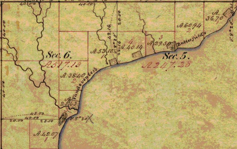
Captains Angus and Butterfield were south of Houghton Point, in what is now the City of Washburn. Detail from the Barber Brothers’ survey during August of 1855.
I answered in the negative. Capt Angus told me that he had told Joseph Lapointe on his sleigh and that he would pay him for it. Steven Butterfield told me that he heard Capt Angus tell Joseph Lapointe to take the Old Man on his sleigh. in the Evening I told Mrs Lapointe the Mother of Joseph and she said her son was very foolish in not taken the old man in his sleigh, but that she had herself told him not to take any person on his sleigh before he was paid for it as he had been cheated so often, and perhaps her son had refused the old man for the reason that the old man had once refused to lend him a bucket to water his horse.
Sworn on March 10th 1856 before me
J W Bell Justice.
– – – – –
Joseph Lapointe
duly sworn says, that he left the Bay with his horse to come to Lapointe on thursday afternoon that the deseased wanted to come over with him in his sleigh that he offered the deseased to bring him over to Lapointe with his things for half a Dollar but the Deseased would not agree to give it to him.
I then turned my horse and came away, on the road he broke an Iron pin and went back to Mr Angus to get it repaired that the Deseased was still there that Mr Angus did not say any thing to him at all in regard to bringing the old man over. Mr Angus never asked him to bring the old man over.
Says that the reason that he did not want any thing in his sleigh was because he wanted to get to Lapointe and back the same day.
Sworn to before me this 10th day of March 1856,
J W Bell Justice
An inquisition taken at Lapointe in the County of Lapointe, on the 10th day of March 1856 before J W Bell one of the Justices of the peace of said County, upon the view of the Body of Jerry Sullivan there dead by the Jurors whose names are hereunto Subscribed, who being duly sworn to Enquire on behalf of the people of this State when, in what manner, and by what means the said Jerry Sullivan came to his death upon their Oaths do say, that from the Evedince produced on their inquest that they Exempt any person from blame, and that owing to the late hour of starting the deceased came to his Death by freezing in making an effort to reach home.
In testimony whereof the said Justice of the Peace and the Jurors of this inquest have hereunto set their hands the day and year aforesaid.
John W. Bell
Justice of the Peace
W. J. Cochran
M. H. Mandelbaum
John Bono
Antoine Perrinier
Edward Fornier
John B. Roy~ Jury ~
Patrick Sullivan
Son of the diseased being duly sworn Says that Deseased was not possesed of any real Estate, and all the personal Estate that he knows of was
Money to the amount of 35.00 which he left with my wife, 7.00 which he lent me, 6 cents was found in his pocket after his disease and 1 Barrel of Flour which I got of him valued at 20.00. Making $62.06. He told me that Captain Angus Owed him for some labor, likewise he had some potatoes hid in the ground and some wood in the woods cut. the Diseased made my house his principal home. he had a due Bill on Mr
J haveAustrian for the Sum of 3.75. Total in Money & due Bills 65.81. also 5.00 worth of meal. 70.81Incidental Expenses paid by me out of the above for
holding an Inquest and Burrial rites, Church Rites &cExpenses of Inquest Jury fees & witnesses &c $8.37
Paid for Coffin & Outer Box 9.38
Paid the Preist for a Mass 5.00
To 4 Men looking for Diseased 4.00
Paid Paul Souliere 2.00
Henry Brissette 1.00
Michael Brissette for teaming 1.00
two Indian Boys for bringing Deseased 2.00
John Cochran two Days. 3.00
Hauling Sand for grave 4.50
[Bisson?] 1 Day searching for diseased 1.00
Ten Dollars for a Railing round the Grave 10.00
Grave Stone 5.00
To Massers to be said hereafter 15.00
Decided that Patrick Sullivan is the proper person to collect and settle all affairs of the diseased. and what remain he is entitled to for his trouble.
Early Trails and Water Routes
August 3, 2016
By Amorin Mello

United States. Works Progress Administration:
Chippewa Indian Historical Project Records 1936-1942
(Northland Micro 5; Micro 532)
Abstract
“Records of a WPA project to collect Chippewa Indian folklore sponsored by the Great Lakes Indian Agency and directed by Sister M. Macaria Murphy of St. Mary’s Indian School, Odanah, Wisconsin. Included are narrative and statistical reports, interview outlines, and operational records; and essays concerning Chippewa religious beliefs and rituals, food, liquor, transportation, trade, clothing, games and dances, and history. Also includes copies of materials from the John A. Bardon collection concerning the Superior, Wisconsin region, La Pointe baptismal records, the family tree of Qui-ka-ba-no-kwe, and artwork of Peter Whitebird.”
Reel 1, Envelope 2, Item 1
Editor’s Note: This article is the result of the information given by the staff, also gleanings from the “Bardon Collection.”
EARLY TRAILS AND WATER ROUTES
~ Fifty Years in the Northwest, by W. H. C. Folsom, 1888, page 258.
Bardon in his Collections says, “From the earliest times, the waterways were the Red Man’s highways: naturally the fur-trader, explorer, and missionary followed the same routes.”
For hundreds of years before the white man came to live in this country, the Indians rarely traveled on land except to portage their canoes in taking short cuts from one body of water to another, thus cutting off considerable distance for extensive traveling. Then, too, game was plentiful on the banks of rivers and lakes. For these reasons the Indian preferred traveling by water to that of land.
For the white man in the early 50’s as well as for the Indian, transportation could be carried on only by water in the lowlands and by trails in the uplands, therefore, canoes were extensively used in the former and quite commonly employed in the latter, for the highlands, too, and their lakes and streams.
Water Routes
An important route connecting the Great Lakes and the Mississippi was by way of the Brule and the St. Croix Rivers. This water route began at Lake Superior, ascended the Brule River to Lake St. Croix then descended the St. Croix River to the Mississippi. The first eastern settler, missionaries, explorers, traders and Indians used this route very extensively.
Another route connecting Lake Superior and the Mississippi River was made by the historian, Schoolcraft, over a hundred years ago. This historic water route began at Chequamegon Bay, ascended the Bad River, and descended the Namekagon and the St. Croix Rivers to the Mississippi.
A route by way of Fish Creek from Chequamegon Bay was also important. Indian travelers portaged their canoes from Fish Creek to White River and down this river for several miles and again portaged to Lake Namakagon, from thence to Namakagon River, thence to the St. Croix and down to the Mississippi. This same route could be taken to the Flambeau and the Wisconsin Rivers by going upstream on the St. Croix.
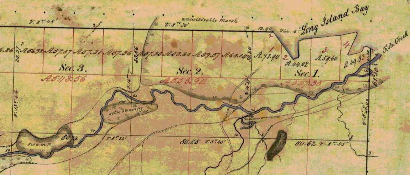
Several trails converged at the mouth of Fish Creek on Chequamegon Bay. ~ Wisconsin Public Land Survey Records
Trails
In traveling by trail most Indians traveled on foot, but many used dog-teams and toboggans, and in some cases, ponies. The Lake Superior region was a permanent camping ground for the Chippewa. This country for many miles around, and numerous trails branching off in all directions, far too many for us to mention each individually. Here we shall point out only the more important ones.
Talking Trail
“Talking Trail”, was so named on account of its beginning at a popular meeting or camping site situated where the city of Washburn now stands. “Talking Trail” began at this camping ground, thence it extended south, to Fish Creek, then south-west for a few miles, finally west to Superior, thus connecting Chequamegon Bay and Superior.
The “Talking Trail” began at the mouth of Vanderventer Creek near Washburn, and was also known as the “Council Trail.”
~ Wisconsin Public Land Survey Records
Bad River Trail
Whether or not this old trail was specifically known as designated above, the title is quite appropriate, since it began at the Leihy Mill on Bad River, Odanah, ran south to Tyler’s Forks, thence to Lake Namakagon and on to Lac Court Oreilles Reservation.
Indian War Trail
The reason for this name is evident: This trail was much used by the Chippewa in time of strife with the Sioux. The War Trail ran east to Montreal River and on to Porcupine Mountains, then to Ontonagon, thence to the copper country, including L’Anse and Marquette, Michigan. Mrs. Frank La Fernier of the Bad River Reservation, (1937) whose father, Mr. James lived to the age of one hundred-three years, corroborated this statement. Mr. James carried United States mail over this trail from our section of the country.
Moccasin Mike Trail

Chief Joseph Ozaagii was a cosigner of the 1854 Treaty at La Pointe on behalf of the Fond Du Lac Band.
~ Geni.com
“Moccasin Mike Trail”, was only another name for the “Osaugee1 Trail”. It was one of the most historic trails, and was evidently named after the local chief, Osaugee, who was the father-in-law of Charles Lord, a latter resident of Solon Springs, but originally a pioneer Quebec trader and voyageur.
This famous trail extended from the south of the St. Louis River, down Wisconsin Pointe, thence along the southern shore of Lake Superior to La Pointe, Bayfield, Ashland, Ontonagon, and the “Copper Country” of Michigan.
A branch of this trail led south, along the Montreal River to central Wisconsin, and was the route of the fur trader from Lake Superior to Green Bay. In the late 50’s and early 60’s, this trail was the land route East and South, and was much used by the early missionaries, traders and pioneer settlers. It became the regular mail route between all “south shore” points. Owen Sheridan and R.S. Mclean were two of the early mail carriers on this trail, packing on foot during the summer and fall, and travelling by dog team in winter.

“Osawgee Beach” postcard, circa 1920.
~ Zenith City Online
When Superior was started in 1853, a new branch of this trail began at the Nemadji River crossing and followed the mainland east, practically along the present high-ways 10 and 2, through what is now Alloues and Itasca, then east over the route of the present drive to an intersection with the main trail near Dutchman’s Creek. The early settlers remember it well. The density of the woods through which it passed kept the trail free from drifting snows and cutting winter winds. Snow shoes, toboggans, and dog teams were a powerful aid to travelers over this early trail.

Detail of Michael S. Bright Sr.‘s trading post on Saint Louis Bay near Oneota (West Duluth).
~ General Land Office Records
With the march of civilization, the settler, and the coming of regularly laid out roads, this intensely historic trail became practically eliminated. In the early 90’s, the Board of Douglas County in conjunction with the city of Superior saw the need of an all-year-round road to Lake Superior and Wisconsin Point. The project was sponsored by Michael S. Bright, now of Duluth, then a member of the County Board from the second ward of Superior. As the Supervisor of the Ward was always dubbed some Indian name, Mr. Bright fell heir to the sobriquet of “Moccasin Mike”. Because the rejuvenated road followed the old Osaugee Trail, and Mr. Bright had been very active in its building, the County Board officially designated the new road: “The Moccasin Mike Trail”.
1 Chief Osaugee was one of the signers of the important Treaty with the Chippewa in 1854. In Vol 2 “Treaties”, compiled by Chas. J. Kappler, the chief’s name is spelled: O sau’gee. The Chippewa spelling is: Osagi, the a being pronounced like a in ah, and the i like e in he.
TRAILS BECOME HIGHWAYS
“… the navigable waters leading into the Mississippi and St. Lawrence, and the carrying places between the same, shall be common highways and forever free …”
Many of the old Indian trails, especially those bordering on the southern shores of Lake Superior, have become permanent highways, and a number of these took their rise in our own village of Odanah. One of these led to Lac du Flambeau, and is now our present U.S. No. 2.
Over-Ridge Trail
This one-time Indian trail ran through Hurley, Wisconsin, Ironwood, Bessemer, Wakefield, and beyond Marinesco, Michigan, where it turned south to Lac du Flambeau. The Indians called the trail: “Ka-ke-way-wa-jwie-no-con”, meaning – “Over Ridge Trail”. At the turning point, it was necessary to cross a small river called “Ka-ba-no-ti-go-ge-wung” or “Presque Isle River”.
White River Trail
Another old Indian trail, leading West out of Odanah followed the [????] of our present U.S. No. 2; after crossing the Chicago and North Western railroad just a few feet west of the steel Railroad Bridge at the west entrance of the village, this trail entered the outskirts of Ashland where it turned directly towards Lake Superior. From thence it followed what is now Front Street in Ashland, turning south at the present site of the Knight Hotel. Following Ellis Avenue, it later crossed “Wa-bi-si-bi,” or White River. Mr. Scott, one of our historical staff says, “At that time there was a solid jam of flood wood at that point. Elm trees blew down on top of the jam, making it sufficiently solid for all kinds of Indian traffic.”

Detail of trails in Ashland east to Odanah and south to the White River. ~ Wisconsin Public Land Survey Records
This Indian Trail ran through Fifield, Wisconsin then straight east to Lac du Flambeau, from thence to Wausau, which was one of the trading posts of the early days. It is now our present U.S. Highway, No. 13.
N.B. An old wagon road known as the St. Paul Road was once a trail when the United States mail was carried on foot. In later years a wagon road was constructed by the War Department for military purposes.
See article following on “Military or St. Paul Road,” By W.P. Bigboy.
Reel 1, Envelope 2, Item 2
MILITARY, OR ST. PAUL, ROAD
By W.P. Bigboy
The road referred to in the “Recollections of Joseph Bell,” was the old military, or St. Paul, road, built by the government during the Civil War.
It followed the trail blazed out in earlier years by “Old Michel Buskey,” later identified as a keeper of a stopping place along this route. These hostelries could be found along the entire route and were for the accommodation and convenience of the early mail packers and travelers, who in the pursuit of their regular missions found the water ways or routes an impediment in the early and proper discharge of their assigned duties. Their locations were spaced by about twenty miles, and in most cases homesteads located near lakes were designated as such. Here mail carriers and other weary travelers, becoming too fatigued to continue farther, could pause and rest, and then continue on their way.
Leaving Bayfield, the first stopping place was at Moose Lake and the second at Loon Lake. These two places were located between Iron River and Bayfield, somewhere in the “Barrens.” The third stop was at Spider Lake. Here lived “Old Michel Buskey,” original trail blazer. His sunny disposition led to the designation of his cheery home as one of the stopping places; and for many years, not only the mail carriers, but many other weary travelers enjoyed the hospitality rendered by this family.
Leaving this place the next stopping place was at Island Lake, near Barnes of today. The next or fifth stop was at Gordon considered the crossroad of the country. Here the traveler usually made an over-night-stop, and enjoyed the hospitality of the village founder, Antoine Gordon.
From Gordon the road continued in a southwesterly direction until it reach near where the Namakagon empties into the St. Croix River. Here John Morrison, the grandfather of the Odanah Morrison, maintained a small hostelry for the accommodation of the traveling public for years. From there the road continued on to Yellow Lake, where another stopping place was located, then the road continued on to St. Croix Falls, where the traffic was ferried across the St. Croix, thence continuing on to St. Paul.
The road was not turnpiked as are the roads of today, but deep gullies and ravines were bridged with stout timbers and lumber, strong enough to bear the heavier armament of the United States Army in the event it became necessary to use the road for the transportation of army equipment.
Reel 1, Envelope 12, Item 3.
EARLY EXPERIENCE
Statement of Joseph Bell, [90?] yrs.
Interviewed by Dan Morrison.
I am in no position to give you much of a story that anyone would care to read, as I am not educated. During my childhood days we did not have the opportunity of going to school that the children now have, and all that I know is what I picked up myself. I have a few things in mind, however, that may be of interest to the present and succeeding generations, pertaining to some old people who were brought up at La Pointe on Madeline Island.

Portrait of Antoine Gordon from Noble Lives of a Noble Race by St. Mary’s Industrial School (Odanah), page 207.
I will tell you about William Gordon’s father raised on Madeline Island, who belongs ot the Lake Superior Band of Chippewa Indians. In the very early days when the United States Government caused roads to be built for the purpose of opening up the country, one of the first roads to be constructed ran from Bayfield to Eau Claire Lakes. This road opened up a vast section of the country, and when new roads were built in those times, people, as a rule, followed in quest for new locations and homes. William Gordon’s [illegible] father did just this. He followed the road from the starting point at Bayfield, running south for some distance, thence west to what they call Moose Lake. This was known as the first station and stopping place. The second station or stopping place was Moon Lake. The third station was at Spider Lake, known now as Silver Lake. The fourth place was Gordon’s, where William Gordon’s father settled. The present town of Gordon represents the first settlement of William Gordon’s father. The fifth stopping place was Yellow River; the sixth, Grantsburg and the seventh, was St. Croix Falls. This was the last stopping place as far as I remember.

The 1820 Cass-Schoolcraft expedition mapped the “Great Trail to the Folle Avoines Country” beginning at the mouth of the Sioux River.
~ Narrative journal of travels from Detroit northwest through the great chain of American lakes to the sources of the Mississippi River in the year 1820, by Henry Rowe Schoolcraft, page 105.
As I said before, these roads opened up a beautiful section of the country, full of wild game, plenty of fur-bearing animals, with many lakes and rivers where fishing was at its best. one could easily make a good living by hunting and trapping, and there was always plenty to eat. Many of the Indians who lived at La Pointe on Madeline Island left the island, following the direction of the newly constructed road. Though they were members of the La Pointe Band of the Lake Superior Chippewa, many remained in the new settlements, and the Indians remaining along the St. Croix River and other adjacent places finally lost their identity on the La Pointe Band and were later known as the “Lost Tribe.”
My great grandfather told me that the Chippewa lived on the south side of Lake St. Croix and the Sioux Indians lived on the north side, both claiming ownership of the St. Croix River. The question of full right of the St. Croix River kindled a feeling of animosity between the two tribes, and failing to arrive at any suitable agreement, war was declared between them, the aim of which was to settle the ownership of the river once and for all. In these encounters the Chippewa conquered the Sioux, driving them out of the country entirely. In their retreat, the Sioux followed a westerly direction, finally stopping where the city of St. Paul stands today.
