1856 Inquest on the Body of Jerry Sullivan
March 18, 2017
By Amorin Mello

Wheeler Family Papers: Box 3, Folder 12;
La Pointe County, 1849-1862
Papers Relating to an
Inquest on the Body of
Jerry Sullivan
~~~
State of Wisconsin
County of Lapointe
To any Constable of said County.
In the name of the State of Wisconsin you are hereby commanded to Summon Joseph Lapointe Oskinawa and [Cotonse for I have?] son of the little chief named [Jegequaon?] to be and appear at my office in Lapointe and give Evedince on an Inquest then & there to be held on the body of P Jerry Sullivan found frozen to death how and by what means he came to his death.
Given under my hand this 10th day of March AD 1856.
J. W. Bell
Justice of the Peace
State of Wisconsin.
To any Constable of the County of Lapointe
You are hereby required immediately to summon six good and lawfull men of the County of Lapointe to appear forthwith before me at my office in the town of Lapointe to enquire upon the view of the Dead Body of Patrick Jerry Sullivan there being dead, how and by what means he came to his death.
Given under my hand this 10th day of March 1856.
J. W. Bell
Justice of the Peace
– – – – – – – – – –
Served the within by Summoning the following Individuals and producing them in Court.
Antoine Perrinier
John Cochran
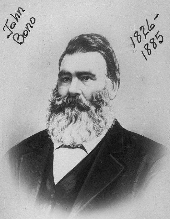
John Bono
Marks Mandelbaum
JB. Roy
Batiste Gaudin
& Edward Fornier
Antoine Cournoyer Sr. was a French-Canadian and father of a mixed-blood family in the La Pointe Band.
A. (his X mark) Cournier
Constable
Fees 50 cts
Inquest on the Body of Jerry Sullivan.
Patrick Sullivan
being duly sworn says that last Thursday evening

Captain John Daniel Angus first settled at La Pointe in 1835.
~ Madeline Island Museum
Oskinawa came to my house, and there a pair of Boots and Blanket and two quilts belonging to the deseased and was going away My little Boy seen him do so. My wife went out of Doors and asked him where the old man was, I heard them talking and I went out. I asked Oskinawa if the old man had left Angus and if he was coming to night, he replied that he did leave him the old man some where on the Ice. I went to see Oskinawa the next day and he told me that an Indian had come across and told him that the old man was sick in a house on the opposite side. I started on Saturday morning in search of the old man and called at the different houses but could get no information of him I also searched along the shore. John Morrison told me that on thursday he seen him with Oskinawa abreast of his place away a good distance from shore on his way to Lapointe. I went to Capt Angus that night to Enquire, Capt Angus told me that he had made an arrangement with Joseph Lapointe to bring the old man home with him as he was coming to Lapointe with a horse and train and he would pay him for it. on Monday afternoon after searching I found the Deseased lying on his back frozen lying on the beach about a mile or more from Lapointe and brought him home and requested that an Inquest should be held over him.
Sworn & subscribed to before me this 10th day of March 1856
J W Bell
Justice of the Peace
Inquest on the Body of Jerry Sullivan
Oskinawe
being duly sworn Says that he knows deceased. Deseased left the Bay to come to lapointe on foot thursday at about half past two o’clock PM.
I overtook him on the road Shortly after I requested the diseased to come along with me as I wanted to get ahead of horse that was going to Lapointe. Mr. Angus had given me the Old Man’s things to bring to Lapointe I had a dog and a train with me the Old Man deseased could not keep up with me and I left him. I overtook the horse at Stoney point and came home in company with the horse Joseph Lapointe had the horse. I could still see the Old Man coming after us when I was this side of the Stoney point.
Sworn to March 10th 1856 before me
J W Bell Justice
– – – – – – – – – –
John [Degequaon?]
being duly sworn says, that on Saturday last he went to the Bay & Capt Angus enquired of him if the old Man had got home.
Captains Angus and Butterfield were south of Houghton Point, in what is now the City of Washburn. Detail from the Barber Brothers’ survey during August of 1855.
I answered in the negative. Capt Angus told me that he had told Joseph Lapointe on his sleigh and that he would pay him for it. Steven Butterfield told me that he heard Capt Angus tell Joseph Lapointe to take the Old Man on his sleigh. in the Evening I told Mrs Lapointe the Mother of Joseph and she said her son was very foolish in not taken the old man in his sleigh, but that she had herself told him not to take any person on his sleigh before he was paid for it as he had been cheated so often, and perhaps her son had refused the old man for the reason that the old man had once refused to lend him a bucket to water his horse.
Sworn on March 10th 1856 before me
J W Bell Justice.
– – – – –
Joseph Lapointe
duly sworn says, that he left the Bay with his horse to come to Lapointe on thursday afternoon that the deseased wanted to come over with him in his sleigh that he offered the deseased to bring him over to Lapointe with his things for half a Dollar but the Deseased would not agree to give it to him.
I then turned my horse and came away, on the road he broke an Iron pin and went back to Mr Angus to get it repaired that the Deseased was still there that Mr Angus did not say any thing to him at all in regard to bringing the old man over. Mr Angus never asked him to bring the old man over.
Says that the reason that he did not want any thing in his sleigh was because he wanted to get to Lapointe and back the same day.
Sworn to before me this 10th day of March 1856,
J W Bell Justice
An inquisition taken at Lapointe in the County of Lapointe, on the 10th day of March 1856 before J W Bell one of the Justices of the peace of said County, upon the view of the Body of Jerry Sullivan there dead by the Jurors whose names are hereunto Subscribed, who being duly sworn to Enquire on behalf of the people of this State when, in what manner, and by what means the said Jerry Sullivan came to his death upon their Oaths do say, that from the Evedince produced on their inquest that they Exempt any person from blame, and that owing to the late hour of starting the deceased came to his Death by freezing in making an effort to reach home.
In testimony whereof the said Justice of the Peace and the Jurors of this inquest have hereunto set their hands the day and year aforesaid.
John W. Bell
Justice of the Peace
W. J. Cochran
M. H. Mandelbaum
John Bono
Antoine Perrinier
Edward Fornier
John B. Roy~ Jury ~
Patrick Sullivan
Son of the diseased being duly sworn Says that Deseased was not possesed of any real Estate, and all the personal Estate that he knows of was
Money to the amount of 35.00 which he left with my wife, 7.00 which he lent me, 6 cents was found in his pocket after his disease and 1 Barrel of Flour which I got of him valued at 20.00. Making $62.06. He told me that Captain Angus Owed him for some labor, likewise he had some potatoes hid in the ground and some wood in the woods cut. the Diseased made my house his principal home. he had a due Bill on Mr
J haveAustrian for the Sum of 3.75. Total in Money & due Bills 65.81. also 5.00 worth of meal. 70.81Incidental Expenses paid by me out of the above for
holding an Inquest and Burrial rites, Church Rites &cExpenses of Inquest Jury fees & witnesses &c $8.37
Paid for Coffin & Outer Box 9.38
Paid the Preist for a Mass 5.00
To 4 Men looking for Diseased 4.00
Paid Paul Souliere 2.00
Henry Brissette 1.00
Michael Brissette for teaming 1.00
two Indian Boys for bringing Deseased 2.00
John Cochran two Days. 3.00
Hauling Sand for grave 4.50
[Bisson?] 1 Day searching for diseased 1.00
Ten Dollars for a Railing round the Grave 10.00
Grave Stone 5.00
To Massers to be said hereafter 15.00
Decided that Patrick Sullivan is the proper person to collect and settle all affairs of the diseased. and what remain he is entitled to for his trouble.
Bayfield’s Early Days
December 22, 2016
By Amorin Mello
This is a reproduction of “Bayfield’s Early Days;” a paper read at Bayfield’s 50th Anniversary by Nazaire LaBonte, as printed in the Bayfield County Press on April 6th, 1906.

“Map of Bayfield situate in La Pointe County, Wisconsin.” By Major McAboy for the Bayfield Land Company in 1856.
~ Wisconsin Historical Society
BAYFIELD’S EARLY DAYS

Nazaire LaBonte
~ FindaGrave.com
Mr. Toast Master, the Bayfield Commercial Club and Ladies and Gentlemen: We are here this evening, as you all know, to commemorate Bayfield’s fiftieth birthday, and I am duly grateful and exceedingly happy to be in your midst this evening, and at the request of the club, to make an accounting of the fifty years just past which was spent here. In order to prepare you for the ordeal, it might be well to remind you that I am not an orator of note, and if I hear some one say, “That man LaBONTE is a cracker Jack of a talker,” don’t you think for a moment I will believe it.
If you are prepared for the worst, I will proceed. I am one of a family of eleven (five boys and six girls) and the son of Francis and Angeline LaBONTE. I was born at Quebec, Canada April 6, 1836, and lived on a farm adjoining that city until I departed for Bayfield which occurred when I was twenty years of age, taking passage at Detroit on the side wheel steamer, Superior, Capt. SWEET commanding the boat. I am not sure, but believe the folks around felt pretty bad when I left, and I have heard since that lots of people in Canada cried when they learned I had quit that country, and it was said I was a brainy man and it was a shame to see me go, and that it would be hard to replace me. I cannot say whether they ever replaced me or not.
John Baptiste Bonneau was the father-in-law of LaBonte, and the namesake of Bono Creek on Chequamegon Bay.
~ FinaGrave.com
Among those who were fellow passengers with me for Bayfield were Benjamin BICKSLER, Frank DAVIDSON, John T. CAHO, and a Mr. WYMAN and a Mr. STEADMAN. Our boat’s cargo consisted of a little of everything including a lot of cattle for Ontonagon, Mich., but on account of a heavy sea that prevailed we were unable to make that port and came on through to LaPointe, Wis., then a stirring village and headquarters of the American Fur Company, where we arrived June 9th 1856, being en route four days as I remember it. The boat did not stop at Bayfield for the reason there was no dock here at that time.
I was anxious to continue on to Superior, but my cash was running low, and when I struck the captain for a ride to that port on the strength of my good looks, or pay fare on the installment, (and all I could scrape up was seventeen cents) the captain, in a gruff way said: “You walk, you pea souper!” I never liked Capt. Sweet since.
The following morning in company with those mentioned, I came over from LaPointe to Bayfield in a rowboat which landed us at the present site of the Dormer BOUTIN Fish Co.’s plant, where there was a dock being built, owned by a Mr. Charles CHILDS of Sault St. Mary, who sometime afterward sold the same to H. M. RICE, C. P. RUDD, and S. L. VAUGHN, and afterwards known as the Vaughn dock, until sold to W. F. DALRYMPLE.
The only building here then was a log house located where M. RYDER’s store now stands, built and owned by the Bayfield Land Company for the accommodation of the men employed by this concern. This company consisted of H. M. RICE, John D. LIVINGSTON, RITTENHOUSE, DAVIDSON and PAYNE. There was not a woman here and it makes me lonesome to make this statement.
That part of the town site lying on the flat was covered by a scattering growth of small Norway pine with an occasional large white pine; and the only thoroughfare was a trail leading from the dock site to the log house mentioned. The hills now dotted with buildings were covered with mixed woods, mostly hardwood.
I found employment here with the Bayfield Land Co., on a mill that was building on the site upon which now stands the R. D. PIKE Lumber Co. mill. The mill was completed and operating in October of that year and about two months afterwards burned down after which I turned my attention to cutting cord wood which was sold to the steamers for fuel purposes.
In the Spring of fifty-seven, I with others started to cut out the Bayfield and St. Paul stage road as far as Yellow Lake, a distance of about 140 miles; the balance of the route to St. Paul was by way of Wood River to Sunrise over logging roads. Sunrise (50 miles from St. Paul) was a junction where the St. Paul stage met both the Bayfield and Superior stages and took their freight and passengers. It required six days to make the trip from Bayfield to St. Paul and the fare was twenty dollars, meals extra at 50 cents each and lodgings the same.
From this time until about 1880, I cut cord wood, logs and made fish barrel staves of clear white pine that was so plentiful at that time.

Matilda Davis; wife of LaBonte and stepdaughter of Bono.
~ FindaGrave.com
On April 4, 1861, I was married to Miss Matilda DAVIS [Bono], Father John CHEBULE officiating.
In the summer of ’61, I went to work in the Red Cliff saw mill (the property of Uncle Sam), which had just been built under contract with the government by Colonel John BANFIELD. I worked there for twelve years in the capacity of sawyer, filer, and scaler on a salary of $3.00 per day. My family and myself resided there about half of the time and the balance of the time in Bayfield. Six men, including myself, constituted the mill crew and the capacity of the mill was six thousand feet per day, which was measured, marked and piled as fast as it left the saw. My neighbor (Commodore Bob INGLIS) was engineer in the mill part of one season, Bob was a good mechanic, a trim, good-looking fellow, and of course was a favorite of the maids on the reservation, and I never found out why he quit that good job and pleasant surroundings so soon. I am told Bob likes the girls yet, but of course, one must not believe all he hears, and allowing that it is the truth, I cannot blame him, for I like the girls myself.
The mill was sold to Duluth parties after operating twelve years, after which I built and kept a summer boarding place known as the LaBONTE house at Bayfield which house was open to the public for many years. I raised a family of four children (Mrs. N. BACHAND and Mrs. CHURCH) who are both here with their families at the present time, and lost a son at the age of six and one half years and also an infant daughter.
My health has always been good, and as far as I know, I am a better man than my wife today. I am seventy years of age, have lived here fifty years and expect to live here fifty years longer, at the expiration of which time if the politics are too corrupt or conditions don’t just suit, I shall move West and grow up with the country.
I am yours very respectfully,
N. LaBONTE
Historic Sites on Chequamegon Bay
July 25, 2016
By Amorin Mello
Historical Sites on Chequamegon Bay was originally published in Collections of the State Historical Society of Wisconsin: Volume XIII, by Reuben Gold Thwaites, 1895, pages 426-440.
HISTORIC SITES ON CHEQUAMEGON BAY.1
—
BY CHRYSOSTOM VERWYST, O.S.F.
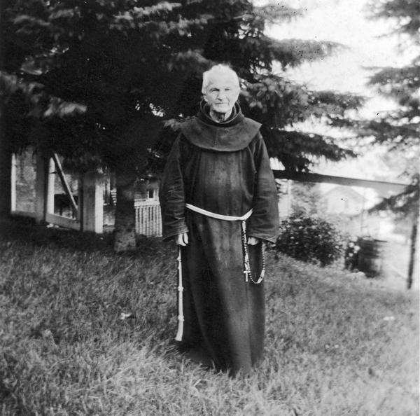
Reverend Chrysostome Verwyst, circa 1918.
~ Wisconsin Historical Society
One of the earliest spots in the Northwest trodden by the feet of white men was the shore of Chequamegon Bay. Chequamegon is a corrupt form of Jagawamikong;2 or, as it was written by Father Allouez in the Jesuit Relation for 1667, Chagaouamigong. The Chippewas on Lake Superior have always applied this name exclusively to Chequamegon Point, the long point of land at the entrance of Ashland Bay. It is now commonly called by whites, Long Island; of late years, the prevailing northeast winds have caused Lake Superior to make a break through this long, narrow peninsula, at its junction with the mainland, or south shore, so that it is in reality an island. On the northwestern extremity of this attenuated strip of land, stands the government light-house, marking the entrance of the bay.

William Whipple Warren, circa 1851.
~ Commons.Wikimedia.org
W. W. Warren, in his History of the Ojibway Nation3, relates an Indian legend to explain the origin of this name. Menabosho, the great Algonkin demi-god, who made this earth anew after the deluge, was once hunting for the great beaver in Lake Superior, which was then but a large beaver-pond. In order to escape his powerful enemy, the great beaver took refuge in Ashland Bay. To capture him, Menabosho built a large dam extending from the south shore of Lake Superior across to Madelaine (or La Pointe) Island. In doing so, he took up the mud from the bottom of the bay and occasionally would throw a fist-full into the lake, each handful forming an island, – hence the origin of the Apostle Islands. Thus did the ancient Indians, the “Gété-anishinabeg,” explain the origin of Chequamegon Point and the islands in the vicinity. His dam completed, Menabosho started in pursuit of the patriarch of all the beavers ; he thinks he has him cornered. But, alas, poor Menabosho is doomed to disappointment. The beaver breaks through the soft dam and escapes into Lake Superior. Thence the word chagaouamig, or shagawamik (“soft beaver-dam”), – in the locative case, shagawamikong (“at the soft beaver-dam”).
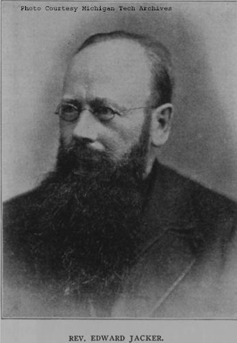
Reverend Edward Jacker
~ FindAGrave.com
Rev. Edward Jacker, a well-known Indian scholar, now deceased, suggests the following explanation of Chequamegon: The point in question was probably first named Jagawamika (pr. shagawamika), meaning “there are long, far-extending breakers;” the participle of this verb is jaiagawamikag (“where there are long breakers”). But later, the legend of the beaver hunt being applied to the spot, the people imagined the word amik (a beaver) to be a constituent part of the compound, and changed the ending in accordance with the rules of their language, – dropping the final a in jagawamika, making it jagawamik, – and used the locative case, ong (jagawamikong), instead of the participial form, ag (jaiagawamikag).4
The Jesuit Relations apply the Indian name to both the bay and the projection of land between Ashland Bay and Lake Superior. our Indians, however, apply it exclusively to this point at the entrance of Ashland Bay. It was formerly nearly connected with Madelaine (La Pointe) Island, so that old Indians claim a man might in early days shoot with a bow across the intervening channel. At present, the opening is about two miles wide. The shores of Chequamegon Bay have from time immemorial been the dwelling-place of numerous Indian tribes. The fishery was excellent in the bay and along the adjacent islands. The bay was convenient to some of the best hunting grounds of Northern Wisconsin and Minnesota. The present writer was informed, a few years ago, that in Douglas county alone 2,500 deer had been killed during one short hunting season.5 How abundant must have been the chase in olden times, before the white had introduced to this wilderness his far-reaching fire-arms! Along the shores of our bay were established at an early day fur-trading posts, where adventurous Frenchmen carried on a lucrative trade with their red brethren of the forest, being protected by French garrisons quartered in the French fort on Madelaine Island.
From Rev. Henry Blatchford, an octogenarian, and John B. Denomie (Denominé), an intelligent half-breed Indian of Odanah, near Ashland, the writer has obtained considerable information as to the location of ancient and modern aboriginal villages on the shores of Chequamegon Bay. Following are the Chippewa names of the rivers and creeks emptying into the bay, where there used formerly to be Indian villages:

Charles Whittlesey documented several pictographs along the Bad River.
Mashki-Sibi (Swamp River, misnamed Bad River): Up this river are pictured rocks, now mostly covered with earth, on which in former times Indians engraved in the soft stone the images of their dreams, or the likenesses of their tutelary manitous. Along this river are many maple-groves, where from time immemorial they have made maple-sugar.
Makodassonagani-Sibi (Bear-trap River), which emptties into the Kakagon. The latter seems in olden times to have been the regular channel of Bad River, when the Bad emptied into Ashland Bay, instead of Lake Superior, as it now does. Near the mouth of the Kakagon are large wild-rice fields, where the Chippewas annually gather, as no doubt did their ancestors, great quantities of wild rice (Manomin). By the way, wild rice is very palatable, and the writer and his dusky spiritual children prefer it to the rice of commerce, although it does not look quite so nice.
Bishigokwe-Sibiwishen is a small creek, about six miles or so east of Ashland. Bishigokwe means a woman who has been abandoned by her husband. In olden times, a French trader resided at the mouth of this creek. He suddenly disappeared, – whether murdered or not, is not known. His wife continued to reside for many years at their old home, hence the name.
Nedobikag-Sibiwishen is the Indian name for Bay City Creek, within the limits of Ashland. Here Tagwagané, a celebrated Indian chief of the Crane totem, used occasionally to reside. Warren6 gives us a speech of his, at the treaty of La Pointe in 1842. This Tagwagané had a copper plate, an heirloom handed down in his family from generation to generation, on which were rude indentations and hieroglyphics denoting the number of generations of that family which had passed away since they first pitched their lodges at Shagawamikong and took possession of the adjacent country, including Madelaine Island. From this original mode of reckoning time, Warren concludes that the ancestors of said family first came to La Pointe circa A. D. 1490.

Detail of “Ici était une bourgade considerable” from Carte des lacs du Canada by Jacques-Nicolas Bellin, 1744.
~ Wisconsin Historical Society
Metabikitigweiag-Sibiwishen is the creek between Ashland and Ashland Junction, which runs into Fish Creek a short distance west of Ashland. At the junction of these two creeks and along their banks, especially on the east bank of Fish Creek, was once a large and populous Indian village of Ottawas, who there raised Indian corn. It is pointed out on N. Bellin’s map (1744)7, with the remark, Ici était une bourgade considerable (“here was once a considerable village”). We shall hereafter have occasion to speak of this place. The soil along Fish Creek is rich, formed by the annual overflowage of its water, leaving behind a deposit of rich, sand loam. There a young growth of timber along the right bank between the bay and Ashland Junction, and the grass growing underneath the trees shows that it was once a cultivated clearing. It was from this place that the trail left the bay, leading to the Chippewa River country. Fish Creek is called by the Indians Wikwedo-Sibiwishen, which means “Bay Creek,” from wikwed, Chippewa for bay; hence the name Wikwedong, the name they gave to Ashland, meaning “at the bay.”

Whittlesey Creek (National Wildlife Refuge) was named after Asaph Whittlesey, brother of Charles Whittlesey. Photo of Asaph, circa 1860.
~ Wisconsin Historical Society
According to Blatchford, there was formerly another considerable village at the mouth of Whittlesey’s Creek, called by the Indians Agami-Wikwedo-Sibiwishen, which signifies “a creek on the other side of the bay,” from agaming (on the other side of a river, or lake), wikwed (a bay), and sibiwishen (a creek). I think that Fathers Allouez and Marquette had their ordinary abode at or near this place, although Allouez seems also to have resided for some time at the Ottawa village up Fish Creek.
A short distance from Whittlesey’s Creek, at the western bend of the bay, where is now Shore’s Landing, there used to be a large Indian village and trading-post, kept by a Frenchman. Being at the head of the bay, it was the starting point of the Indian trail to the St. Croix country. Some years ago the writer dug up there, an Indian mound. The young growth of timber at the bend of the bay, and the absence of stumps, indicate that it had once been cleared. At the foot of the bluff or bank, is a beautiful spring of fresh water. As the St. Croix country was one of the principal hunting grounds of the Chippewas and Sioux, it is natural there should always be many living at the terminus of the trail, where it struck the bay.
From this place northward, there were Indian hamlets strung along the western shore of the bay. Father Allouez mentions visiting various hamlets two, three, or more (French) leagues away from his chapel. Marquette mentions five clearings, where Indian villages were located. At Wyman’s place, the writer some years ago dug up two Indian mounds, one of which was located on the very bank of the bay and was covered with a large number of boulders, taken from the bed of the bay. In this mound were found a piece of milled copper, some old-fashioned hand-made iron nails, the stem of a clay pipe, etc. The objects were no doubt relics of white men, although Indians had built the mound itself, which seemed like a fire-place shoveled under, and covered with large boulders to prevent it from being desecrated.
Boyd’s Creek is called in Chippewa, Namebinikanensi-Sibiwishen, meaning “Little Sucker Creek.” A man named Boyd once resided there, married to an Indian woman. He was shot in a quarrel with another man. One of his sons resides at Spider Lake, and another at Flambeau Farm, while two of his grand-daughters live at Lac du Flambeau.
Further north is Kitchi-Namebinikani-Sibiwishen, meaning “Large Sucker Creek,” but whites now call it Bonos Creek. These two creeks are not far apart, and once there was a village of Indians there. It was noted as a place for fishing at a certain season of the year, probably in spring, when suckers and other fish would go up these creeks to spawn.
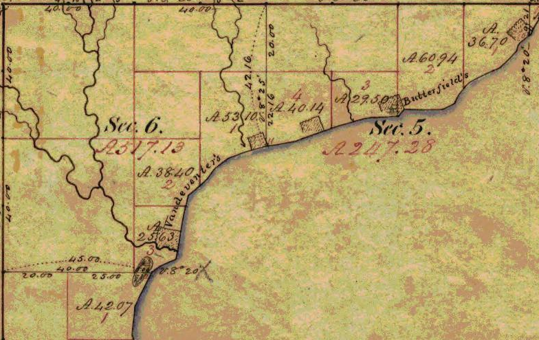
At Vanderventer’s Creek, near Washburn, was the celebrated Gigito-Mikana, or “council-trail,” so called because here the Chippewas once held a celebrated council; hence the Indian name Gigito-Mikana-Sibiwishen, meaning “Council-trail Creek.” At the mouth of this creek, there was once a large Indian village.
There used also to be a considerable village between Pike’s Bay and Bayfield. It was probably there that the celebrated war chief, Waboujig, resided.

John Baptiste Denomie
~ Noble Lives of a Noble Race, A Series of Reproductions by the Pupils of Saint Mary’s, Odanah, Wisconsin, page 213-217.
There was once an Indian village where Bayfield now stands, also at Wikweiag (Buffalo Bay), at Passabikang, Red Cliff, and on Madelaine Island. The writer was informed by John B. Denomie, who was born on the island in 1834, that towards Chabomnicon Bay (meaning “Gooseberry Bay”) could long ago be seen small mounds or corn-hills, now overgrown with large trees, indications of early Indian agriculture. There must have been a village there in olden times. Another ancient village was located on the southwestern extremity of Madelaine Island, facing Chequamegon Point, where some of their graves may still be seen. It is also highly probable that there were Indian hamlets scattered along the shore between Bayfield and Red Cliff, the most northern mainland of Wisconsin. There is now a large, flourishing Indian settlement there, forming the Red Cliff Chippewa reservation. There is a combination church and school there at present, under the charge of the Franciscan Order. Many Indians also used to live on Chequamegon Point, during a great part of the year, as the fishing was good there, and blueberries were abundant in their season. No doubt from time immemorial Indians were wont to gather wild rice at the mouth of the Kakagon, and to make maple sugar up Bad River.

Illustration from The Story of Chequamegon Bay, Collections of the State Historical Society of Wisconsin: Volume XIII, 1895, page 419.
We thus see that the Jesuit Relations are correct when they speak of many large and small Indian villages (Fr. bourgades) along the shores of Chequamegon Bay. Father Allouez mentions two large Indian villages at the head of the bay – the one an Ottawa village, on Fish Creek; the other a Huron, probably between Shore’s Landing and Washburn. Besides, he mentions smaller hamlets visited by him on his sick-calls. Marquette says that the Indians lived there in five clearings, or villages. From all this we see that the bay was from most ancient times the seat of a large aboriginal population. Its geographical position towards the western end of the great lake, its rich fisheries and hunting grounds, all tended to make it the home of thousands of Indians. Hence it is much spoken of by Perrot, in his Mémoire, and by most writers on the Northwest of the last century. Chequamegon Bay, Ontonagon, Keweenaw Bay, and Sault Ste. Marie (Baweting) were the principal resorts of the Chippewa Indians and their allies, on the south shore of Lake Superior.
“Front view of the Radisson cabin, the first house built by a white man in Wisconsin. It was built between 1650 and 1660 on Chequamegon Bay, in the vicinity of Ashland. This drawing is not necessarily historically accurate.”
~ Wisconsin Historical Society
The first white men on the shores of Chequamegon Bay were in all probability Groseilliers and Radisson. They built a fort on Houghton Point, and another at the head of the bay, somewhere between Whittlesey’s Creek and Shore’s Landing, as in some later paper I hope to show from Radisson’s narrative.8 As to the place where he shot the bustards, a creek which led him to a meadow9, I think this was Fish Creek, at the mouth of which is a large meadow, or swamp.10
After spending six weeks in the Sioux country, our explorers retraced their steps to Chequamegon Bay, arriving there towards the end of winter. They built a fort on Houghton Point. The Ottawas had built another fort somewhere on Chequamegon Point. In travelling towards this Ottawa fort, on the half-rotten ice, Radisson gave out and was very sick for eight days; but by rubbing his legs with hot bear’s oil, and keeping them well bandaged, he finally recovered. After his convalescence, our explorers traveled northward, finally reaching James Bay.
The next white men to visit our bay were two Frenchmen, of whom W. W. Warren says:11
“One clear morning in the early part of winter, soon after the islands which are clustered in this portion of Lake Superior, and known as the Apostles, had been locked in ice, a party of young men of the Ojibways started out from their village in the Bay of Shag-a-waum-ik-ong [Chequamegon], to go, as was customary, and spear fish through holes in the ice, between the island of La Pointe and the main shore, this being considered as the best ground for this mode of fishing. While engaged in this sport, they discovered a smoke arising from a point of the adjacent island, toward its eastern extremity.
“The island of La Pointe was then totally unfrequented, from superstitious fears which had but a short time previous led to its total evacuation by the tribe, and it was considered an act of the greatest hardihood for any one to set foot on its shores. The young men returned home at evening and reported the smoke which they had seen arising from the island, and various were the conjectures of the old people respecting the persons who would dare to build a fire on the spirit-haunted isle. They must be strangers, and the young men were directed, should they again see the smoke, to go and find out who made it.
“Early the next morning, again proceeding to their fishing-ground, the young men once more noticed the smoke arising from the eastern end of the unfrequented island, and, again led on by curiosity, they ran thither and found a small log cabin, in which they discovered two white men in the last stages of starvation. The young Ojibways, filled with compassion, carefully conveyed them to their village, where being nourished with great kindness, their lives were preserved.
“These two white men had started from Quebec during the summer with a supply of goods, to go and find the Ojibways who every year had brought rich packs of beaver to the sea-coast, notwithstanding that their road was barred by numerous parties of the watchful and jealous Iroquois. Coasting slowly up the southern shores of the Great Lake late in the fall, they had been driven by the ice on to the unfrequented island, and not discovering the vicinity of the Indian village, they had been for some time enduring the pangs of hunger. At the time they were found by the young Indians, they had been reduced to the extremity of roasting and eating their woolen cloth and blankets as the last means of sustaining life.
“Having come provided with goods they remained in the village during the winter, exchanging their commodities for beaver skins. They ensuing spring a large number of the Ojibways accompanied them on their return home.
“From close inquiry, and judging from events which are said to have occurred about this period of time, I am disposed to believe that this first visit by the whites took place about two hundred years ago [Warren wrote in 1852]. It is, at any rate, certain that it happened a few years prior to the visit of the ‘Black-gowns’ [Jesuits] mentioned in Bancroft’s History, and it is one hundred and eighty-four years since this well-authenticated occurrence.”
So far Warren; he is, however, mistaken as to the date of the first black-gown’s visit, which was not 1668 but 1665.

Portrayal of Claude Allouez
~ National Park Service
The next visitors to Chequamegon Bay were Père Claude Allouez and his six companions in 1665. We come now to a most interesting chapter in the history of our bay, the first formal preaching of the Christian religion on its shores. For a full account of Father Allouez’s labors here, the reader is referred to the writer’s Missionary Labors of Fathers Marquette, Allouez, and Ménard in the Lake Superior Region. Here will be given merely a succinct account of their work on the shores of the bay. To the writer it has always been a soul-inspiring thought that he is allowed to tread in the footsteps of those saintly men, who walked, over two hundred years ago, the same ground on which he now travels; and to labor among the same race for which they, in starvation and hardship, suffered so much.
In the Jesuit Relation for 1667, Father Allouez thus begins the account of his five years’ labors on the shores of our bay:
“On the eight of August of the year 1665, I embarked at Three Rivers with six Frenchmen, in company with more than four hundred Indians of different tribes, who were returning to their country, having concluded the little traffic for which they had come.”
Marquis Alexandre de Prouville de Tracy
~ Wikipedia.org
His voyage into the Northwest was one of the great hardships and privations. The Indians willingly took along his French lay companions, but him they disliked. Although M. Tracy, the governor of Quebec, had made Father Allouez his ambassador to the Upper Algonquins, thus to facilitate his reception in their country, nevertheless they opposed him accompanying them, and threatened to abandon him on some desolate island. No doubt the medicine-men were the principal instigators of this opposition. He was usually obliged to paddle like the rest, often till late in the night, and that frequently without anything to eat all day.
“On a certain morning,” he says, “a deer was found, dead since four or five days. It was a lucky acquisition for poor famished beings. I was offered some, and although the bad smell hindered some from eating it, hunger made me take my share. But I had in consequence an offensive odor in my mouth until the next day. In addition to all these miseries we met with, at the rapids I used to carry packs as large as possible for my strength; but I often succumbed, and this gave our Indians occasion to laugh at me. They used to make fun of me, saying a child ought to be called to carry me and my baggage.”
August 24, they arrived at Lake Huron, where they made a short stay; then coasting along the shores of that lake, they arrived at Sault Ste. Marie towards the beginning of September. September 2, they entered Lake Superior, which the Father named Lake Tracy in acknowledgement of the obligations which the people of those upper countries owed to the governor. Speaking of his voyage on Lake Superior, Father Allouez remarks:
“Having entered Lake Tracy, we were engaged the whole month of September in coasting along the south shore. I had the consolation of saying holy mass, as I now found myself alone with our Frenchmen, which I had not been able to do since my departure from Three Rivers. * * * We afterwards passed the bay, called by the aged, venerable Father Ménard, Sait Theresa [Keweenaw] Bay.”
Speaking of his arrival at Chequamegon Bay, he says:
“After having traveled a hundred and eighty leagues on the south shore of Lake Tracy, during which our Saviour often deigned to try our patience by storms, hunger, daily and nightly fatigues, we finally, on the first day of October, 1665, arrived at Chagaouamigong, for which place we had sighed so long. It is a beautiful bay, at the head of which is situated the large village of the Indians, who there cultivate fields of Indian corn and do not lead a nomadic life. There are at this place men bearing arms, who number about eight hundred; but these are gathered together from seven different tribes, and live in peacable community. This great number of people induced us to prefer this place to all others for our ordinary abode, in order to attend more conveniently to the instruction of these heathens, to put up a chapel there and commence the functions of Christianity.”
Further on, speaking of the site of his mission and its chapel, he remarks:
“The section of the lake shore, where we have settled down, is between two large villages, and is, as it were, the center of all the tribes of these countries, because the fishing here is very good, which is the principal source of support of these people.”
To locate still more precisely the exact site of his chapel, he remarks, speaking of the three Ottawa clans (Outaouacs, Kiskakoumacs, and Outaoua-Sinagonc):
“I join these tribes [that is, speaks of them as one tribe] because they had one and the same language, which is the Algonquin, and compose one of the same village, which is opposite that of the Tionnontatcheronons [Hurons of the Petun tribe] between which villages we reside.”
But where was that Ottawa village? A casual remark of Allouez, when speaking of the copper mines of Lake Superior, will help us locate it.
“It is true,” says he, “on the mainland, at the place where the Outaouacs raise Indian corn, about half a league from the edge of the water, the women have sometimes found pieces of copper scattered here and there, weighing ten, twenty or thirty pounds. It is when digging into the sand to conceal their corn that they make these discoveries.”
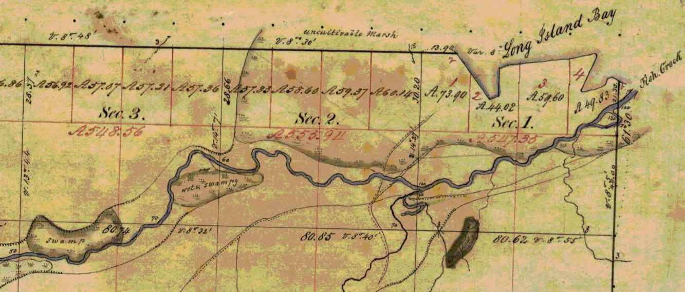
Detail of Fish Creek from Township 47 North Range 5 West.
~ Wisconsin Public Land Survey Records
Allouez evidently means Fish Creek. About a mile or so from the shore of the bay, going up this creek, can be seen traces of an ancient clearing on the left-hand side, where Metabikitigweiag Creeek empties into Fish Creek, about half-way between Ashland and Ashland Junction. The writer examined the locality about ten years ago. This then is the place where the Ottawas raised Indian corn and had their village. In Charlevoix’s History of New France, the same place is marked as the site of an ancient large village. The Ottawa village on Fish Creek appears to have been the larger of the two at the head of Chequamegon Bay, and it was there Allouez resided for a time, until he was obliged to return to his ordinary dwelling place, “three-fourths of a league distant.” This shows that the ordinary abode of Father Allouez and Marquette, the site of their chapel, was somewhere near Whittlesey’s Creek or Shore’s Landing. The Huron village was most probably along the western shore of the bay, between Shore’s Landing and Washburn.

Detail of Ashland next to an ancient large village (unmarked) in Township 47 North Range 4 West.
~ Wisconsin Public Land Survey Records
Father Allouez did not confine his apostolic labors to the two large village at the head of the bay. He traveled all over the neighborhood, visiting the various shore hamlets, and he also spent a month at the western extremity of Lake Superior – probably at Fond du Lac – where he met with some Chippewas and Sioux. In 1667 he crossed the lake, most probably from Sand Island, in a frail birch canoe, and visited some Nipissirinien Christians at Lake Nepigon (Allimibigong). The same year he went to Quebec with an Indian flotilla, and arrived there on the 3d of August, 1667. After only two days’ rest he returned with the same flotilla to his far distant mission on Chequamegon Bay, taking along Father Louis Nicholas. Allouez contained his missionary labors here until 1669, when he left to found St. Francis Xavier mission at the head of Green Bay. His successor at Chequamegon Bay was Father James Marquette, discoverer and explorer of the Mississippi. Marquette arrived here September 13, 1669, and labored until the spring of 1671, when he was obliged to leave on account of the war which had broken out the year before, between the Algonquin Indians at Chequamegon Bay and their western neighbors, the Sioux.
1 – See ante, p. 419 for map of the bay. – ED.
2 – In writing Indian names, I follow Baraga’s system of orthography, giving the French quality to both consonants and vowels.
3 – Minn. Hist. Colls., v. – ED.
4 – See ante, p. 399, note. – ED.
5 – See Carr’s interesting and exhaustive article, “The Food of Certain American Indians,” in Amer. Antiq. Proc., x., pp. 155 et seq. – ED.
6 – Minn. Hist. Colls., v. – ED.
7 – In Charlevoix’s Nouvelle France. – ED.
8 – See Radisson’s Journal, in Wis. Hist. Colls., xi. Radisson and Groseilliers reached Chequamegon Bay late in the autumn of 1661. – ED.
9 – Ibid., p. 73: “I went to the wood some 3 or 4 miles. I find a small brooke, where I walked by ye sid awhile, wch brought me into meddowes. There was a poole, where weare a good store of bustards.” – ED.
10 – Ex-Lieut. Gov. Sam. S. Fifield, of Ashland, writes me as follows:
“After re-reading Radisson’s voyage to Bay Chewamegon, I am satisfied that it would by his description be impossible to locate the exact spot of his camp. The stream in which he found the “pools,” and where he shot fowl, is no doubt Fish Creek, emptying into the bay at its western extremity. Radisson’s fort must have been near the head of the bay, on the west shore, probably at or near Boyd’s Creek, as there is an outcropping of rock in that vicinity, and the banks are somewhat higher than at the head of the bay, where the bottom lands are low and swampy, forming excellent “duck ground” even to this day. Fish Creek has three outlets into the bay, – one on the east shore or near the east side, one central, and one near the western shore; for full two miles up the stream, it is a vast swamp, through which the stream flows in deep, sluggish lagoons. Here, in the early days of American settlement, large brook trout were plenty; and even in my day many fine specimens have been taken from these “pools.” Originally, there was along these bottoms a heavy elm forest, mixed with cedar and black ash, but it has now mostly disappeared. An old “second growth,” along the east side, near Prentice Park, was evidently once the site of an Indian settlement, probably of the 18th century.
“I am of the opinion that the location of Allouez’s mission was at the mouth of Vanderventer’s Creek, on the west shore of the bay, near the present village of Washburn. It was undoubtedly once the site of a large Indian village, as was the western part of the present city of Ashland. When I came to this locality, nearly a quarter of a century ago, “second growth” spots could be seen in several places, where it was evident that the Indians had once had clearings for their homes. The march of civilization has obliterated these landmarks of the fur-trading days, when the old French voyageurs made the forest-clad shores of our beautiful bay echo with their boat songs, and when resting from their labors sparked the dusky maidens in their wigwams.”
Rev. E. P. Wheeler, of Ashland, a native of Madelaine Island, and an authority on the region, writes me:
“I think Radisson’s fort was at the mouth of Boyd’s Creek, – at least that place seems for the present to fulfill the conditions of his account. it is about three or four miles from here to Fish Creek valley, which leads, when followed down stream, to marshes ‘meadows, and a pool.’ No other stream seems to have the combination as described. Boyd’s Creek is about four miles from the route he probably took, which would be by way of the plateau back from the first level, near the lake. Radisson evidently followed Fish Creek down towards the lake, before reaching the marshes. This condition is met by the formation of the creek, as it is some distance from the plateau through which Fish Creek flows to its marshy expanse. Only one thing makes me hesitate about coming to a final decision, – that is, the question of the age of the lowlands and formations around Whittlesey Creek. I am going to go over the ground with an expert geologist, and will report later. Thus far, there seems to be no reason to doubt that Fish Creek is the one upon which Radisson hunted.” – ED.
11 – Minn. Hist. Colls., v., pp. 121, 122, gives the date as 1652. – ED.
