1837 Petitions from La Pointe to the President
January 29, 2023
Collected & edited by Amorin Mello
Letters Received by the Office of Indian Affairs:
La Pointe Agency 1831-1839
National Archives Identifier: 164009310
O. I. A. La Pointe J171.
Hon Geo. W. Jones
Ho. of Reps. Jany 9, 1838
Transmits petition dated 31st Augt 1837, from Michel Cadotte & 25 other Chip. Half Breeds, praying that the amt to be paid them, under the late Chip. treaty, be distributed at La Pointe, and submitting the names of D. P. Bushnell, Lyman M. Warren, for the appt of Comsr to make the distribution.
Transmits it, that it may receive such attention as will secure the objects of the petitioners, says as the treaty has not been satisfied it may be necessary to bring the subject of the petition before the Comsr Ind Affrs of the Senate.
Recd 10 Jany 1838
file
[?] File.
House of Representatives Jany 9th 1838

Sir
I hasten to transmit the inclosed petition, with the hope, that the subject alluded to, may receive such attention, as to secure the object of the petitioners. As the Chippewa Treaty has not yet been ratified it may be necessary to bring the subject of the petition before the Committee of Indian Affairs of the Senate.
I am very respectfully
Your obt svt
Geo W. Jones
C. A. Harris Esqr
Comssr of Indian Affairs
War Department

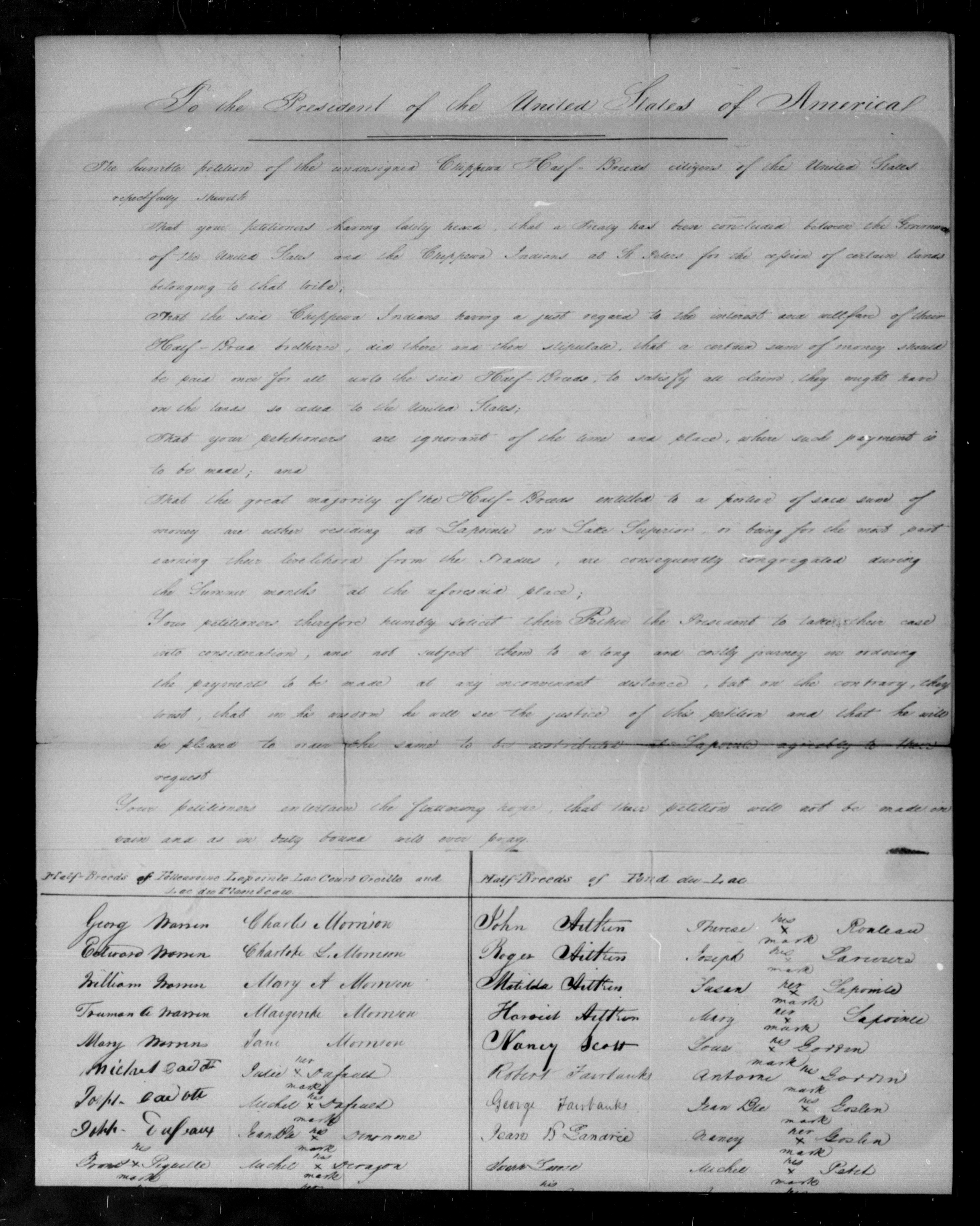
To the President of the United States of America
The humble petition of the undersigned Chippewa Half-Breeds citizens of the United Sates, respectfully Shareth:

Bizhiki (Buffalo), Dagwagaane (Two Lodges Meet), and Jechiikwii’o (Snipe, aka Little Buffalo) signed the 1837 Treaty of St Peters for the La Pointe Band.
That, your petitioners having lately heard that a Treaty had been concluded between the Government of the United Sates and the Chippewa Indians at St Peters, for the cession of certain lands belonging to that tribe:
ARTICLE 3.
“The sum of one hundred thousand dollars shall be paid by the United States, to the half-
breeds of the Chippewa nation, under the direction of the President. It is the wish of the
Indians that their two sub-agents Daniel P. Bushnell, and Miles M. Vineyard, superintend
the distribution of this money among their half-breed relations.”
That, the said Chippewa Indians X, having a just regard to the interest and welfare of their Half Breed brethren, did there and then stipulate; that, a certain sum of money should be paid once for all unto the said Half-Breeds, to satisfy all claim they might have on the lands so ceded to the United States.
That, your petitioners are ignorant of the time and place where such payment is to be made.
That the great majority of the Half-Breeds entitled to a distribution of said sum of money, are either residing at La Pointe on Lake Superior, or being for the most part earning their livelihood from the Traders, are consequently congregated during the summer months at the aforesaid place.
Your petitioners humbly solicit their father the President, to take their case into consideration, and not subject them to a long and costly journey in ordering the payments to be made at any inconvenient distance, but on the contrary they trust that in his wisdom he will see the justice of their demand in requiring he will be pleased to order the same to be distributed at Lapointe agreeable to their request.
Your petitioners would also intimate that, although they are fully aware that the Executive will make a judicious choice in the appointment of the Commissioners who will be selected to carry into effect the Provisions of said Treaty, yet, they would humbly submit to the President, that they have full confidence in the integrity of D. P. Bushnell Esqr. resident Indian Agent for the United States at this place and Lyman M Warren Esquire, Merchant.
Your petitioners entertain the flattering hope, that, their petition will not be made in vain, and as in duty bound will ever pray.
La Pointe, Lake Superior,
Territory of Wisconsin 31st August 1837
Michel Cadotte
Michel Bosquet X his mark
Seraphim Lacombe X his mark
Joseph Cadotte X his mark
Antoine Cadotte X his mark
Chs W Borup for wife & Children
A Morrison for wife & children
Pierre Cotte
Henry Cotte X his mark
Frances Roussan X his mark
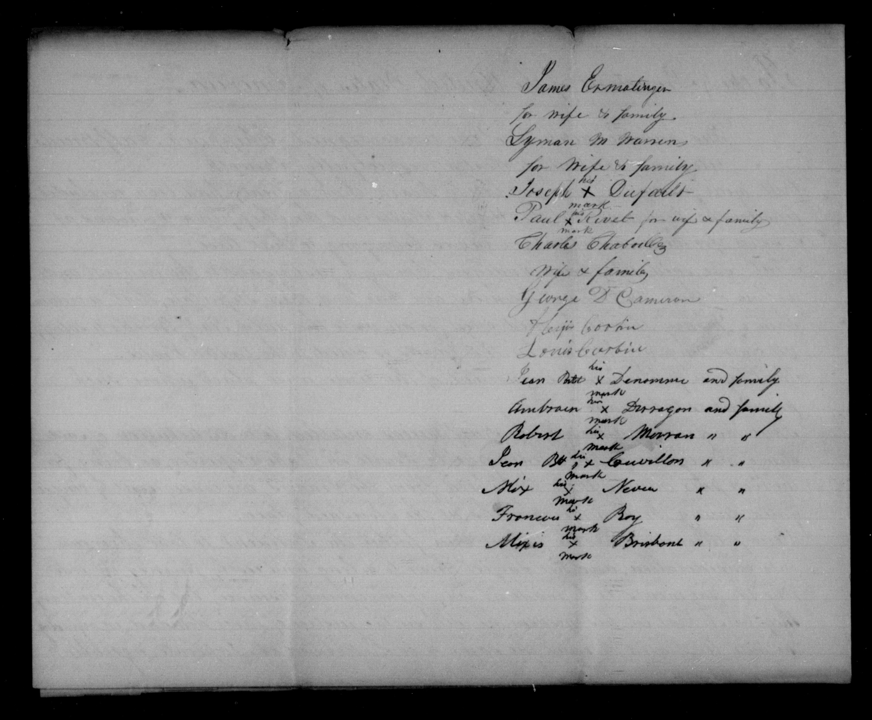
James Ermatinger for wife & family
Lyman M Warren for wife & family
Joseph Dufault X his mark
Paul Rivet X his mark for wife & family
Charles Chaboullez wife & family
George D. Cameron
Alixis Corbin
Louis Corbin
Jean Bste Denomme X his mark and family
Ambrose Deragon X his mark and family
Robert Morran X his mark ” “
Jean Bst Couvillon X his mark ” “
Alix Neveu X his mark ” “
Frances Roy X his mark ” “
Alixis Brisbant X his mark ” “
Signed in presence of G. Pauchene
John Livingston
O.I.A. La Pointe W424.
Governor of Wisconsin
Mineral Pt. Feby 19, 1838
Transmits the talk of “Buffalo,” a Chip. Chief, delivered at the La Pointe SubAgt, Dec. 9, 1837, asking that the am. due the half-breeds under the late Treaty, be divided fairly among them, & paid them there, as they will not go to St Peters for it, &c.
Says Buffalo has great influence with his tribe, & is friendly to the whites; his sentiments accord with most of those of the half-breeds & Inds in that part of the country.
File
Recd 13 March 1838
[?] File.
Superintendency of Indian Affairs
for the Territory of Wisconsin
Mineral Point, Feby 19, 1838

Sir,
I have the honor to inclose the talk of “Buffalo,” a principal chief of the Chippewa Indians in the vicinity of La Pointe, delivered on the 9th Dec’r last before Mr Bushnell, sub-agent of the Chippewas at that place. Mr. Bushnell remarks that the speech is given with as strict an adherence to the letter as the language will admit, and has no doubt the sentiments expressed by this Chief accord with those of most of the half-breeds and Indians in that place of the Country. The “Buffalo” is a man of great influence among his tribe, and very friendly to the whites.
Very respectfully,
Your obed’t sevt.
Henry Dodge
Supt Ind Affs
Hon C. A. Harris
Com. of Ind. Affairs
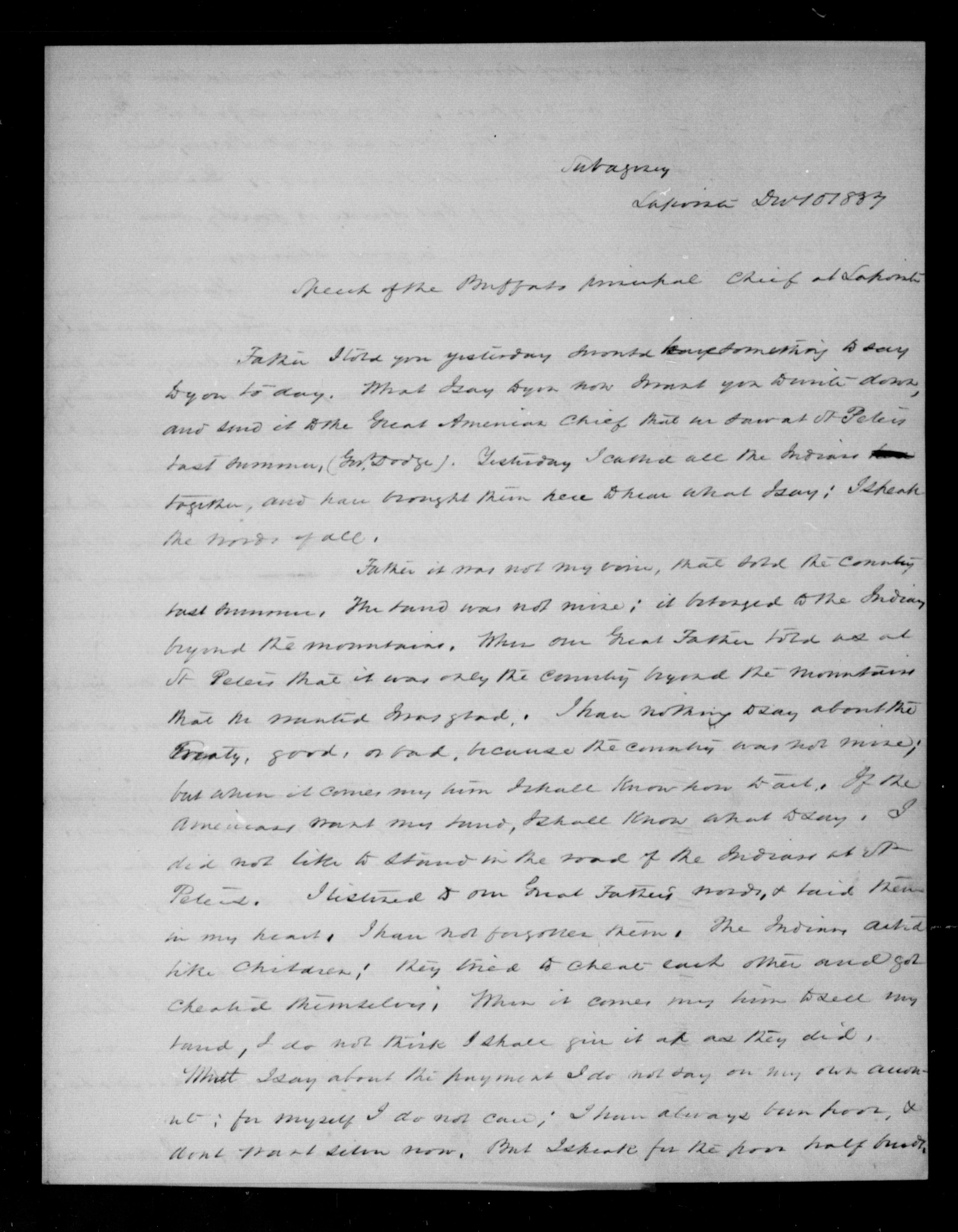
Subagency
Lapointe Dec 10 1837
Speech of the Buffalo principal Chief at Lapointe
Father I told you yesterday I would have something to say to you today. What I say to you now I want you to write down, and send it to the Great American Chief that we saw at St Peters last summer, (Gov. Dodge). Yesterday, I called all the Indians together, and have brought them here to hear what I say; I speak the words of all.
ARTICLE 1.
“The said Chippewa nation cede to the United States all that tract of country included
within the following boundaries:
[…]
thence to and along the dividing ridge between the waters of Lake Superior and those of the Mississippi
[…]“
Father it was not my voice, that sold the country last summer. The land was not mine; it belonged to the Indians beyond the mountains. When our Great Father told us at St Peters that it was only the country beyond the mountains that he wanted I was glad. I have nothing to say about the Treaty, good, or bad, because the country was not mine; but when it comes my time I shall know how to act. If the Americans want my land, I shall know what to say. I did not like to stand in the road of the Indians at St Peters. I listened to our Great Father’s words, & said them in my heart. I have not forgotten them. The Indians acted like children; they tried to cheat each other and got cheated themselves. When it comes my time to sell my land, I do not think I shall give it up as they did.
What I say about the payment I do not say on my own account; for myself I do not care; I have always been poor, & don’t want silver now. But I speak for the poor half breeds.
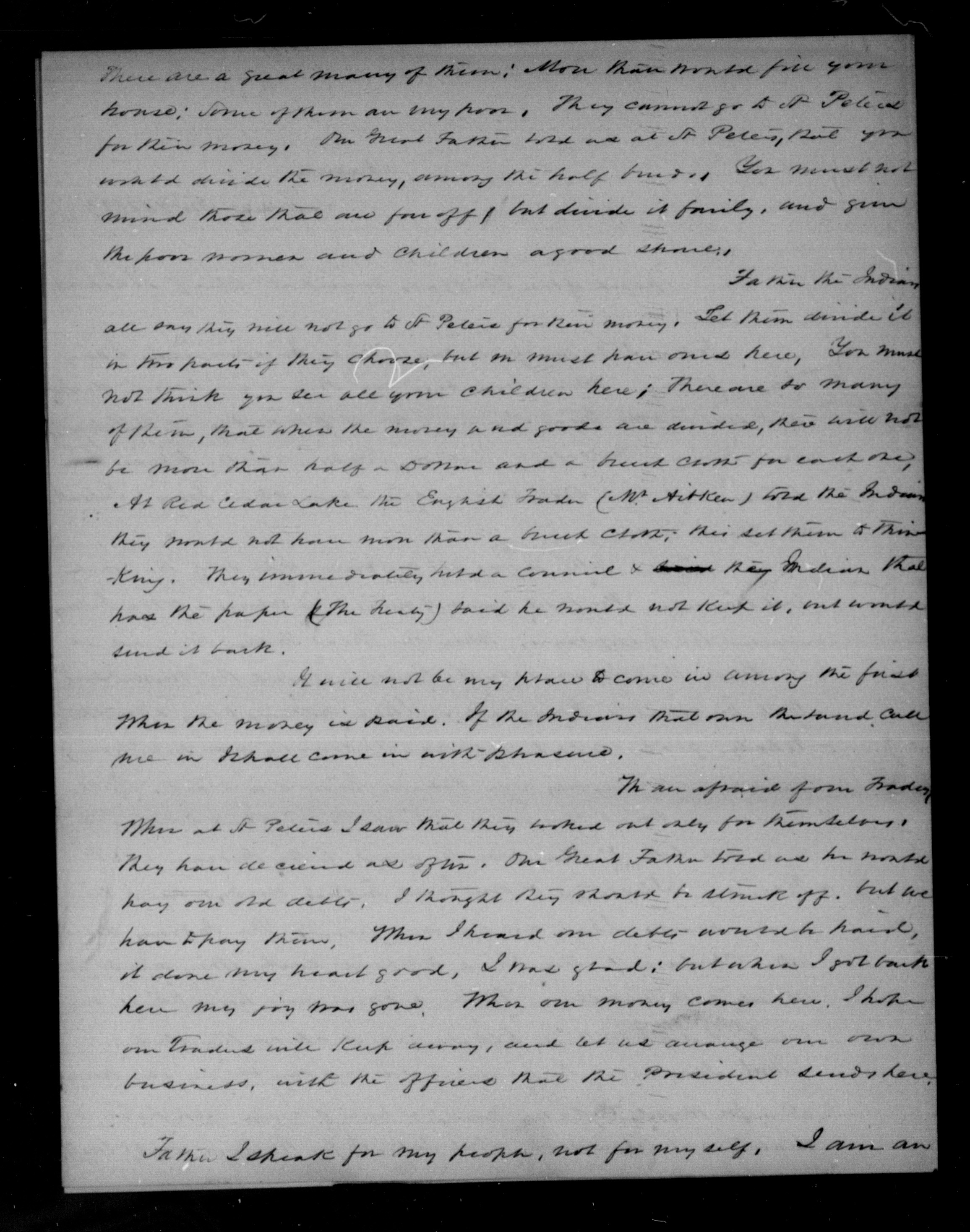
There are a great many of them; more than would fill your house; some of them are very poor They cannot go to St Peters for their money. Our Great Father told us at St Peters, that you would divide the money, among the half breeds. You must not mind those that are far off, but divide it fairly, and give the poor women and children a good share.
Father the Indians all say they will not go to St Peters for their money. Let them divide it in this parts if they choose, but one must have ones here. You must not think you see all your children here; there are so many of them, that when the money and goods are divided, there will not be more than half a Dollar and a breech cloth for each one. At Red Cedar Lake the English Trader (W. Aitken) told the Indians they would not have more than a breech cloth; this set them to thinking. They immediately held a council & their Indian that had the paper (The Treaty) said he would not keep it, and would send it back.
It will not be my place to come in among the first when the money is paid. If the Indians that own the land call me in I shall come in with pleasure.
ARTICLE 4.
“The sum of seventy thousand dollars shall be applied to the payment, by the United States, of certain claims against the Indians; of which amount twenty eight thousand dollars shall, at their request, be paid to William A. Aitkin, twenty five thousand to Lyman M. Warren, and the balance applied to the liquidation of other just demands against them—which they acknowledge to be the case with regard to that presented by Hercules L. Dousman, for the sum of five thousand dollars; and they request that it be paid.“
We are afraid of one Trader. When at St Peters I saw that they worked out only for themselves. They have deceived us often. Our Great Father told us he would pay our old debts. I thought they should be struck off, but we have to pay them. When I heard our debts would be paid, it done my heart good. I was glad; but when I got back here my joy was gone. When our money comes here, I hope our Traders will keep away, and let us arrange our own business, with the officers that the President sends here.
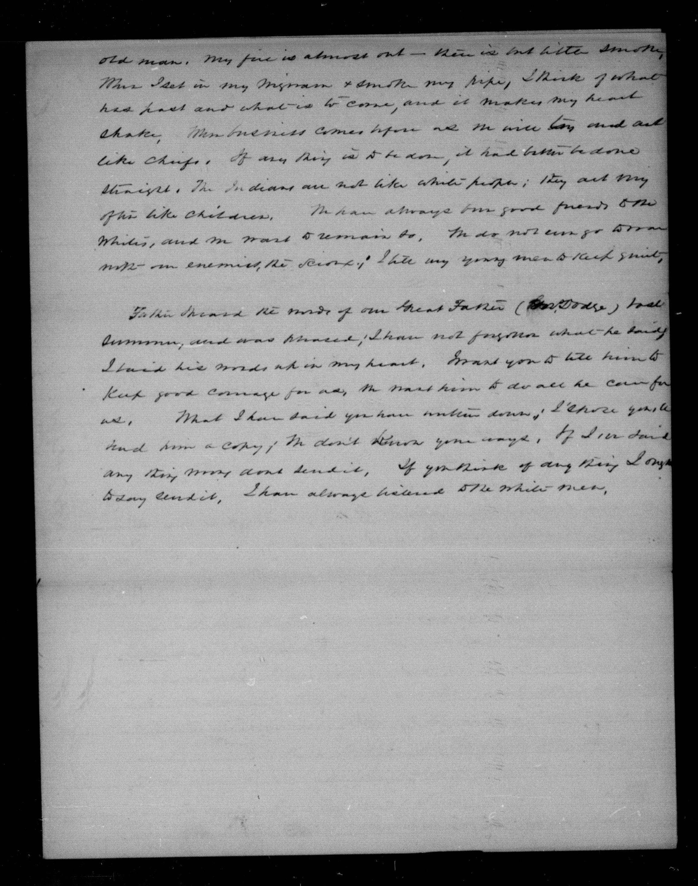
Father I speak for my people, not for myself. I am an old man. My fire is almost out – there is but little smoke. When I set in my wigwam & smoke my pipe, I think of what has past and what is to come, and it makes my heart shake. When business comes before us we will try and act like chiefs. If any thing is to be done, it had better be done straight. The Indians are not like white people; they act very often like children. We have always been good friends to the whites, and we want to remain so. We do not [even?] go to war with our enemies, the Sioux; I tell my young men to keep quiet.
Father I heard the words of our Great Father (Gov. Dodge) last summer, and was pleased; I have not forgotten what he said. I have his words up in my heart. I want you to tell him to keep good courage for us, we want him to do all he can for us. What I have said you have written down; I [?] you to hand him a copy; we don’t know your ways. If I [?] said any thing [?] dont send it. If you think of any thing I ought to say send it. I have always listened to the white men.
O.I.A. Lapointe, B.458
D. P. Bushnell
Lapointe, March 8, 1838
At the request of some of the petitioners, encloses a petition dated 7 March 1838, addressed to the Prest, signed by 167 Chip. half breeds, praying that the amt stipulated by the late Chip. Treaty to be paid to the half breeds, to satisfy all claims they ma have on the lands ceded by this Treaty, may be distributed at Lapointe.
Hopes their request will be complied with; & thinks their annuity should likewise be paid at Lapointe.
File
Recd 2nd May, 1838
Subagency
Lapointe Mch 6 1838
Sir
I have the honor herewith to enclose a petition addressed to the President of the United States, handed to me with a request by several of the petitioners that I would forward it. The justice of the demand of these poor people is so obvious to any one acquainted with their circumstances, that I cannot omit this occasion to second it, and to express a sincere hope that it will be complied with. Indeed, if the convenience and wishes of the Indians are consulted, and as the sum they receive for their country is so small, these should, I conciev, be principle considerations, their annuity will likewise as paid here; for it is a point more convenient of access for the different bands, that almost any other in their own country, and one moreover, where they have interests been in the habit of assembling in the summer months.
I am sir, with great respect,
your most obt servant,
D. P. Bushnell
O. I. A.
C. A. Harris Esqr.
Comr Ind. Affs
To the President of the United States of America
The humble petition of the undersigned Chippewa Half-Breeds citizens of the United States respectfully shareth
That your petitioners having lately heard, that a Treaty has been concluded between the Government of the United States and the Chippewa Indians at St Peters for the cession of certain lands belonging to that tribe;
That the said Chippewa Indians having a just regard to the interest and wellfare of their Half-Breed brethern, did there and then stipulate, that a certain sum of money should be paid once for all unto the said Half-Breeds, to satisfy all claims, they might have on the lands so ceded to the United States;
That your petitioners are ignorant of the time and place, where such payment is to be made; and
That the great majority of the Half-Breeds entitled to a portion of said sum of money are either residing at Lapointe on Lake Superior, or being for the most part earning their livelihood from the Traders, are consequently congregated during the summer months at the aforesaid place;
Your petitioners therefore humbly solicit their Father the President to take their case into consideration, and not subject them to a long and costly journey on ordering the payment to be made at any convenient distance, but on the contrary, they wish, that in his wisdom he will see the justice of this petition and that he will be pleased to order the same to be distributed at Lapointe agreeably to their request.
Your petitioners entertain the flattering hope, that their petition will not be made in vain and as in duly bound will ever pray.
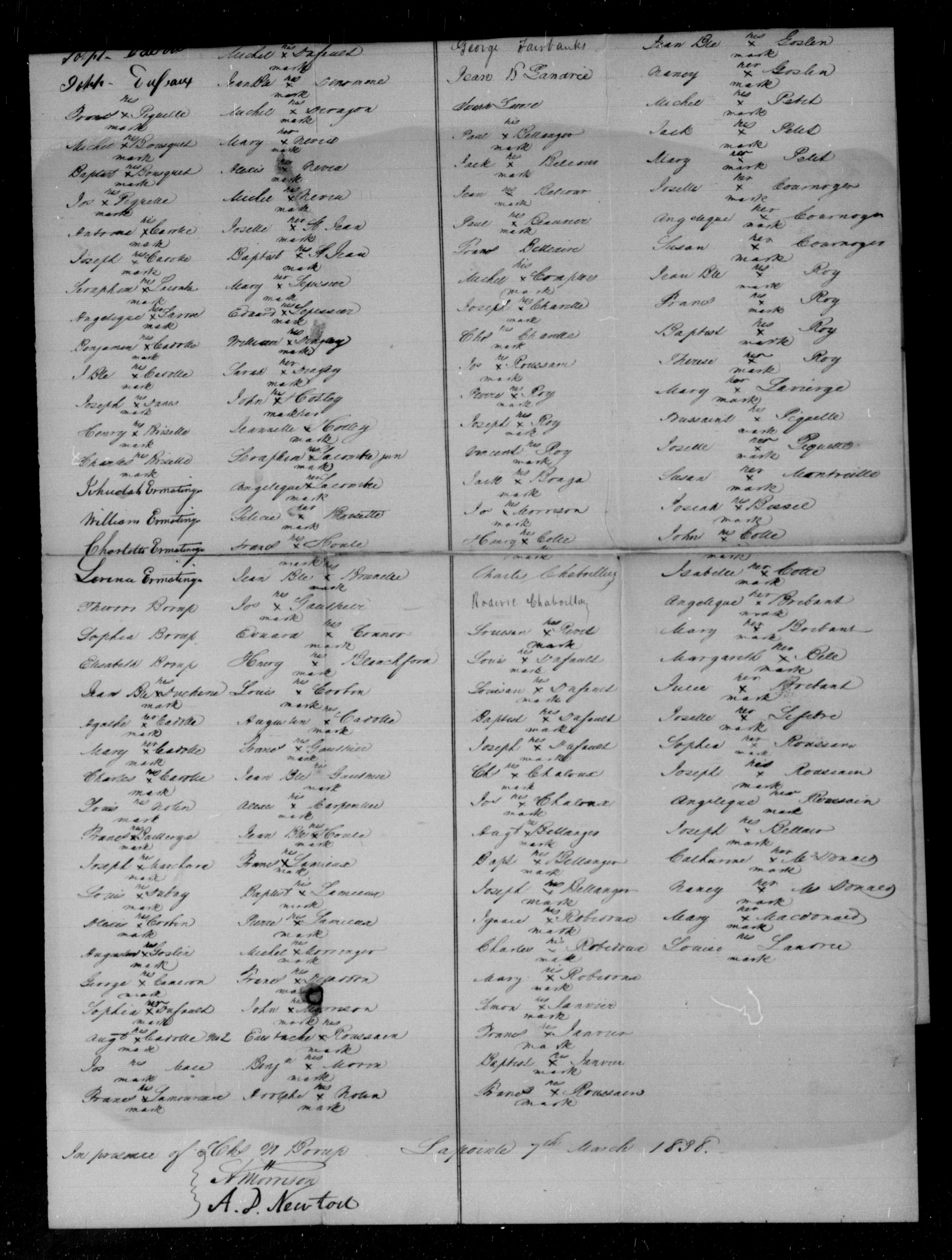
Half Breeds of Folleavoine Lapointe Lac Court Oreilles and Lac du Flambeau
Georg Warren
Edward Warren
William Warren
Truman A Warren
Mary Warren
Michel Cadott
Joseph Cadotte
Joseph Dufault
Frances Piquette X his mark
Michel Bousquet X his mark
Baptiste Bousquet X his mark
Jos Piquette X his mark
Antoine Cadotte X his mark
Joseph Cadotte X his mark
Seraphim Lacombre X his mark
Angelique Larose X her mark
Benjamin Cadotte X his mark
J Bte Cadotte X his mark
Joseph Danis X his mark
Henry Brisette X his mark
Charles Brisette X his mark
Jehudah Ermatinger
William Ermatinger
Charlotte Ermatinger
Larence Ermatinger
Theodore Borup
Sophia Borup
Elisabeth Borup
Jean Bte Duchene X his mark
Agathe Cadotte X her mark
Mary Cadotte X her mark
Charles Cadotte X his mark
Louis Nolin _ his mark
Frances Baillerge X his mark
Joseph Marchand X his mark
Louis Dubay X his mark
Alexis Corbin X his mark
Augustus Goslin X his mark
George Cameron X his mark
Sophia Dufault X her mark
Augt Cadotte No 2 X his mark
Jos Mace _ his mark
Frances Lamoureau X his mark
Charles Morrison
Charlotte L. Morrison
Mary A Morrison
Margerike Morrison
Jane Morrison
Julie Dufault X her mark
Michel Dufault X his mark
Jean Bte Denomme X his mark
Michel Deragon X his mark
Mary Neveu X her mark
Alexis Neveu X his mark
Michel Neveu X his mark
Josette St Jean X her mark
Baptist St Jean X his mark
Mary Lepessier X her mark
Edward Lepessier X his mark
William Dingley X his mark
Sarah Dingley X her mark
John Hotley X his mark
Jeannette Hotley X her mark
Seraphim Lacombre Jun X his mark
Angelique Lacombre X her mark
Felicia Brisette X her mark
Frances Houle X his mark
Jean Bte Brunelle X his mark
Jos Gauthier X his mark
Edward Connor X his mark
Henry Blanchford X his mark
Louis Corbin X his mark
Augustin Cadotte X his mark
Frances Gauthier X his mark
Jean Bte Gauthier X his mark
Alexis Carpentier X his mark
Jean Bte Houle X his mark
Frances Lamieux X his mark
Baptiste Lemieux X his mark
Pierre Lamieux X his mark
Michel Morringer X his mark
Frances Dejaddon X his mark
John Morrison X his mark
Eustache Roussain X his mark
Benjn Morin X his mark
Adolphe Nolin X his mark
Half-Breeds of Fond du Lac
John Aitken
Roger Aitken
Matilda Aitken
Harriet Aitken
Nancy Scott
Robert Fairbanks
George Fairbanks
Jean B Landrie
Joseph Larose
Paul Bellanges X his mark
Jack Belcour X his mark
Jean Belcour X his mark
Paul Beauvier X his mark
Frances Belleaire
Michel Comptois X his mark
Joseph Charette X his mark
Chl Charette X his mark
Jos Roussain X his mark
Pierre Roy X his mark
Joseph Roy X his mark
Vincent Roy X his mark
Jack Bonga X his mark
Jos Morrison X his mark
Henry Cotte X his mark
Charles Chaboillez
Roderic Chaboillez
Louison Rivet X his mark
Louis Dufault X his mark
Louison Dufault X his mark
Baptiste Dufault X his mark
Joseph Dufault X his mark
Chs Chaloux X his mark
Jos Chaloux X his mark
Augt Bellanger X his mark
Bapt Bellanger X his mark
Joseph Bellanger X his mark
Ignace Robidoux X his mark
Charles Robidoux X his mark
Mary Robidoux X her mark
Simon Janvier X his mark
Frances Janvier X his mark
Baptiste Janvier X his mark
Frances Roussain X his mark
Therese Rouleau X his mark
Joseph Lavierire X his mark
Susan Lapointe X her mark
Mary Lapointe X her mark
Louis Gordon X his mark
Antoine Gordon X his mark
Jean Bte Goslin X his mark
Nancy Goslin X her mark
Michel Petit X his mark
Jack Petit X his mark
Mary Petit X her mark
Josette Cournoyer X her mark
Angelique Cournoyer X her mark
Susan Cournoyer X her mark
Jean Bte Roy X his mark
Frances Roy X his mark
Baptist Roy X his mark
Therese Roy X her mark
Mary Lavierge X her mark
Toussaint Piquette X his mark
Josette Piquette X her mark
Susan Montreille X her mark
Josiah Bissel X his mark
John Cotte X his mark
Isabelle Cotte X her mark
Angelique Brebant X her mark
Mary Brebant X her mark
Margareth Bell X her mark
Julie Brebant X her mark
Josette Lefebre X her mark
Sophia Roussain X her mark
Joseph Roussain X his mark
Angelique Roussain X her mark
Joseph Bellair X his mark
Catharine McDonald X her mark
Nancy McDonald X her mark
Mary Macdonald X her mark
Louise Landrie X his mark
In presence of
Chs W Borup
A Morrison
A. D. Newton
Lapointe 7th March 1838
Treaty Allotments at Copper Falls
February 17, 2022
Collected & edited by Amorin Mello

Chippewa Treaty (blue) and Sioux Script (red) treaty land allotments in the Penokee Mountains located along mineral deposits near Mellen, Wisconsin.
[LaPointe County Register of Deeds: Volume 2 Deeds Page 419]

Julius Austrian had better success entering lands with Chippewa Certificates along the iron range for the Leopold & Austrian family’s La Pointe Iron Company than here along the copper range.
Be it known to all men that I Julius Austrian of Lapointe County State of Wisconsin am held and firmly Bound unto Julius [Bernault?], Peter King, Abraham Comartin, John W Bell & Henry Merryweather and to Each of them Separately in the Sum of One thousand Dollars for which payment will and truly to be made I bind my self my heirs executors and administrators firmly by these presents.
The condition of the above obligations are such that whereas the above mentioned Julius [Bernault?], Peter King, Abraham Comartin, John W Bell & Henry Merryweather having Squatted and improved the following mentioned Lands in Lapointe County with the intent of Claiming the Same as a Town Site namely the East half of Section No Seventeen (17) of Township number Forty five (45) of Range no two (2) and have agreed with the said Julius Austrian that he may enter the above described lands by Chippewa Script or otherwise at his option.

The “East half of Section No Seventeen (17) …” is where the Bad River and Tyler Forks River join spectacularly at what is now Brownstone Falls in Copper Falls State Park.
Now if the said Julius Austrian shall with due diligence enter the same as provided and obtain a Patent or Patents as Early as possible from the United States, and within 10 Days from the time he may procure and obtain said Patent or Patents for the above mentioned lands whether in his name or in the names of other parties, make execute & deliver or cause so to be done, to each of the above mentioned parties a Good & Sufficient Deed of warrantee clear of all incumbrances of an undivided Four ninetieths part of the whole mentioned East half of said Section no 17 as above specified. Then this obligation to be null & voice, otherwise to Remain in full force and virtue.
Given under my hand and seal at Lapointe this 30th day of April 1858.
Julius Austrian {Seal}
In presence of
Henry Smitz
M H Mandelbaum
State of Wisconsin } S.S.
County of Lapointe }
Personally came before the undersigned a Notary Public in & For the County of Lapointe the within named Julius Austrian to me well known who acknowledged that he did execute sign & seal the within Bond as his free Act and Deed.
{Seal} M H Mandelbaum
Notary Public
[Ashland County Register of Deeds: Volume 1 Deeds Pages 264-268]
{$180.00 Stamp Int Revenue U.S.}
This Indenture made the twenty fifth day of May in the year one thousand eight hundred and sixty four Between Louis Stein of the City and State of New York individually, Margaret Dupuis by Loius Stein her attorney, Charlotte Mercier by Louis Stein her attorney, Hypolite Auger by Louis Stein her attorney, Julia Renville by Louis Stein her attorney and Louise Moreau by Louis Stein her attorney, parties of the first part, and the Ashland Copper Mining Company, a Corporation created under and by virtue of the laws of the State of Wisconsin, party of the second part.
Whereas the north half of the North East quarter of Section Seventeen (17) in Township number Forty five (45) of Range Two (2) west in the District of Lands subject to Sale at Bayfield Wisconsin containing eighty acres according to the Government Survey was located on the 14th day of October 1863 with Chippewa Half Breed Scrip No 228 by John B Corbin,
and also the South Half of the North East Quarter of of Section Seventeen (17) Township Forty Five (45) Range Two (2) in the District of Lands subject to Sale at Bayfield Wisconsin containing eighty acres according to Government Survey was located on the 28th day of September 1863 with Chippewa Scrip Number 209 by John P Hamlin attorney for John Baptiste Denomie,
and also the North East half of South East quarter of Section Seventeen (17) Township Forty five (45) Range two (2) West in the District of Lands subject to Sale at Bayfield Wisconsin containing eighty acres according to the Government Survey was located October 14th 1863 with Chippewa Half Breed Scrip No 161 issued to John Haskins by John P Hamlin attorney,
and also the North East Quarter of South West quarter of Section Seventeen (27) Township Forty Five (45) Range Two (2) west in the District of lands subject to sale at Bayfield Wisconsin containing Forty acres according to the Government Survey was located October 20th 1863 with Sioux Scrip No 212 B by Louis Stein attorney for Margaret Dupuis,
And also the North West Quarter of South West quarter of Section Seventeen (17) Township number Forty five North of Range Two (2) West in the District of Lands subject to Sale at Bayfield Wisconsin containing Forty acres according to the Government Survey was located on November 25th 1863 with Sioux Half Breed Scrip No 102 B by Louis Stein attorney for Charlotte Mercier,
And also the South East Quarter of Section Eighteen (18) Township Forty five (45) North of Range Two (2) West in the District of Lands subject to Sale at Bayfield Wisconsin containing one hundred and sixty acres according to the Government Survey, was located on the 25th day of November 1863 with Sioux Half Breed Scrip No 487 C by Louis Stein attorney for Hypolite Auger,
And also the South half of South West Quarter of Section Seventeen (17) Township Forty five (45) Range Two (2) in the District of Lands subject to Sale at Bayfield Wisconsin containing eighty acres according to the Government Survey was located October 18th 1863 with Sioux Half Breed Scrip No 212 Letter C by Louis Stein attorney for Margaret Dupuis,
And also the North half of the North West quarter of Section Twenty (20) Township Forty five (45) North of Range 2 west in the District of lands subject to Sale at Bayfield Wisconsin containing eighty acres according to the Government Survey was located September 10th 1863 with Chippewa Half Breed Scrip No 158 by Julius Austrian attorney,
And also the South Half of South East Quarter of Section Seventeen (17) Township Forty five (45) Range Two (2) West in the District of Lands subject to Sale at Bayfield Wisconsin containing eighty acres according to the Government Survey was located on the 14th day of October 1863 with Chippewa Half Breed Scrip No 281 issued to Michael Lambert by John P Hamlin attorney,
And also the North East quarter of Section nineteen (19) Township No Forty five (45) Range Two (2) West in the District of Lands subject to Sale at Bayfield Wisconsin containing one hundred and Sixty acres according to the Government Survey was located on the 19th day of October 1863 with Sioux Half Breed Scrip No 29 by Louis Stein attorney for Julia Renville,
And also the North half of South East quarter and East Half of the South West quarter of Section Number nineteen (19) Township No Forty five (45) Range Two (2) West in the District of Lands subject to Sale at Bayfield Wisconsin containing One hundred and Sixty acres according to the Government Survey was located on the 19th day of October 1963 with Sioux Half Breed Scrip No 17 C by Louis Stein attorney for Louise Moreau.
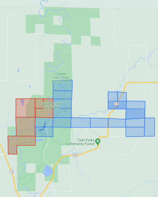
Chippewa and Sioux treaty land allotments in and contiguous to Copper Falls State Park. There are more Chippewa allotments here than those claimed by Ashland Copper Mining Company. Others went to Robert Morrin, Joseph Roy, Francis S. Gurnoe, John Chapman, Francis Fournier, Rosalie Trocquer, John Baptiste Visneau, Henry Davenport, Edward Ashman, Henry Graham, Mary Graham, Joseph Blanchard, and Reuben Chapman.
And whereas said North Half of North East Quarter of Section Seventeen (17) in Township No Forty five (45) of Range Two west was conveyed by John B Corbin and Wife to John P Hamlin by Deed dated October 17th 1863, and Recorded in the Office of Register of Deeds of Ashland County Wisconsin in Book of Deeds Vol 1 pages 218 & 219 October 18, 1863 and was further conveyed by said John P Hamlin to Louis Stein by Deed dated October 31st 1863, and Recorded in said Registers office in Book of Deeds Vol 1 Page 225 November 9th 1863,

John Baptiste Denomie Jr of Odanah; son of allottee Jean Baptiste Denomie Sr.
~ Noble Lives of a Noble Race, A Series of Reproductions by the Pupils of Saint Mary’s, Odanah, Wisconsin, 1909, page 213-217.
And whereas said South Half of the North east quarter of Section Seventeen (17) Township Forty five (45) Range Two (2) has been conveyed by the said John Baptiste Denomie to Louis Stein by Deed dated May 25th 1864,
and said North East Half of South East Quarter of Section Seventeen (17) Township Forty five (45) Range Two(2) west has been conveyed by said John Haskins to said Louis Stein by Deed dated May 25th 1864,
and said South East Quarter of Section Eighteen (18) Township Forty five (45) North of range two (2) west has been conveyed by Hypolite Auger to said Louis Stein by Deed Dated January 1, 1862 and recorded in said Office of Register of Deeds in Vol 1 of Deeds page 227 January 23 1864,

The Ashland Copper Mine was mapped by Irving in 1873 for the Geology of Wisconsin: Volume III. This was located at what is now the main picnic area on Michael Lambert’s Chippewa Allotment in Copper Falls State Park.
and said South Half of South East quarter of Section Seventeen (17) Township Forty five (45) Range two (2) West has been conveyed by the said Michael Lambert to the said Louis Stein by Deed dated May 25th 1864,
and the said Louis Stein has also acquired the title of the said North Half of the North West quarter of Section twenty (20) Township Forty five (45) North of Range two (2) West from the said Julius Austrian.
And whereas the said parties of the first part to these presents have sold and agreed to convey to the said party of the second part to these presents a tract of land situated in the County of Ashland in the State of Wisconsin which includes the whole or parts of the several tracts pieces and parcels of land herein before described which said tract of land so sold and agreed to be conveyed to the said party of the second part is hereinafter particularly described.
Now Therefore this Indenture Witnesseth that the said parties of the first part for and in consideration of Twenty thousand shares of the Capital Stocks of the said party of the second part of the value of five dollars for each Share, which have been issued or transferred and assigned to them the said parties of the first part or as they have appointed and directed, the receipt of which is hereby acknowledged, have granted, bargained, sold, released, conveyed, and confirmed and by these presents do grant, bargain, sell, release, convey and confirm unto the said party of the second part its successors and assigns forever

Copper Falls by Emily Fritts, August 2016.
~ WikiMedia Commons
All that certain tract and parcel of Land situate, lying and being in the County of Ashland in the State of Wisconsin, known bounded and described as follows to wit;
Beginning at a point in the center of Bad River in Township Number Forty five (45) North Range Number Two (2) West of the Fourth Meridian where said river crosses the northerly boundary of Section number Seventeen (17) in the North East quarter, thence running west eight hundred (800) feet more or less to the North West corner of said North East quarter Section; thence South twenty six hundred and forty (2640) feet to the center of Section number Seventeen (17); thence West Five thousand two hundred and eighty feet (5280) to the center of Section number eighteen (18); thence South Five thousand two hundred and eighty (5280) feet to the center of Section number nineteen (18); thence west thirteen hundred and twenty (1320) feet; thence South twenty six hundred and forty (2640) feet; thence East thirteen hundred and twenty (1320) feet; thence North twenty three hundred and ninety (2390) feet more or less to the center of said Bad River and thence North Easterly along the center of said Bad River as it runs to the place of beginning, containing six hundred and fifty three acres (653) more or less and being portions of Section numbers seventeen (17), eighteen (18), nineteen (19) and twenty (20) in the aforesaid Township.

Brownstone Falls in Copper Falls State Park by Yinan Chen.
~ WikiMedia Commons
To have and to hold the above described and hereby granted premises and every part and parcel thereof together with all and singular the tenements hereditaments and appurtenances thereunto belonging or in anywise appertaining unto the said party of the second part its successors and assigns to its and their own purpose, use, benefit and behoof forever. And the said parties of the first part severally for himself and herself and not the one for the other, and for his and her heirs executors and administrators do hereby covenant promise and agree to and with the said party of the second part, its successors and assigns to make, execute, sign, seal, acknowledge and deliver at the Cost and expense of the said party of the second part its successors and assigns all such other and further Deeds, grants, conveyances and instruments in writing as the said party of the second part its successors and assigns or its or their Counsel learned in the law shall at any times advise, devise or require for the [more?] effectually conveying to and vesting in the said party of the second part its successors and assigns the fee simple of the above described and hereby granted, promised and every part thereof with the appurteances. And the said Margaret DuPuis, Charlotte Mercier, Hypolite Auger, Julia Renville and Louise Moreau severally and not the one for the other and each of them only in respect to so much of the hereby conveyed premises as is located by or for him or her as herein before stated and set forth and is hereby conveyed by him or her or intended so to be for himself and herself, his and her heirs, executors and administrators covenant and agree to and with the said party of the second part its successors and assigns in the manner and form following that is to say That he or she at the time of the ensealing and delivery of these presents is the true, lawful and rightful owner of the said hereby conveyed premises, and has therein a good sure, perfect and indefeasible estate in fee simple; and that he and she has full right, power and authority to grant, bargain, sell, remise, release, convey and confirm the said premises unto the said party of the second part its successors and assigns in manner and form aforesaid and that the said party of the second part its successors and assigns shall quietly enjoy and possess the said premises and that he and she will Warrant and Defend the title to the same against all lawful claims.
In Witness Whereof the said parties of the first part have hereunto set their hands and Seals they day and year first above written
Louis Stein {S.S.}
Margaret Dupuis by Louis Stein atty {S.S.}
Charlotte Mercier by Louis Stein atty {S.S.}
Hypolite Auger by Louis Stein attorney {S.S.}
Julia Renville by Louis Stein Attorney {S.S.}
Louis Moreau by Louis Stein attorney {S.S.}
Sealed and delivered in Presence
A H Wallis
Andrew Clerk
State of New York } S.S.
County of New York }
Be it Remembered that on this seventh day of June in the year eighteen hundred and sixty four before the subscriber a Commissioner in and for the said State, appointed by the Governor of the State of Wisconsin to take acknowledgment and proof of the execution of Deeds, or other conveyances or leases and of any contract, letter of attorney or other writing under seal or not administer oaths and take and certify depositions to be used or recorded in the said State of Wisconsin appeared Louis Stein whom I know to be the person described in and who executed the foregoing instrument and acknowledged that he executed the same in his own behalf as his own act and deed and also acknowledged that he executed the same as the act and deed of Margaret Dupuis, Charlotte Mercier, Hypolite Auger, Julia Renville & Louise Moreau therein descried by virtue of a Power of Attorney severally executed by them authorizing the same, and which Power of Attorney have been duly exhibited to me by the said Louis Stein.
Given under my hand and Official Seal
{Seal} Charles E Jenkins Commissioner for the State of Wisconsin, residing in the city of New York.
By Leo
In April, the Supreme Court heard arguments in the case Department of Commerce v. New York and could render a decision any day on whether or not the 2020 federal census should include a question asking about citizenship status. In January, a Federal District Court in New York ruled that commerce secretary, Wilbur Ross, violated the law by pushing for that question.
Those in agreement with the District ruling suggest that the Trump administration wants to add the question as a way of discouraging immigrants from participating in the census, thereby diminishing the political power of immigrant communities. This, they say, would violate the Constitution on the grounds that the census must be an “actual enumeration” of all persons within the United States, not only citizens.
Proponents of the citizenship question counter that citizenship status is a perfectly natural question to ask in the census, that any government would want to know how many citizens it has, and that several past iterations of the 10-year count have included similar questions.
It remains to be seen how the Supreme Court will rule, but chances are it will not be the last time an issue of race, identity, or citizenship pops up in the politics of the census. From its creation by the Constitution as a way to apportion seats in congress according to populations of the states, the count has always begged tricky questions that essentially boil down to:
Who is a real American? Who isn’t? Who is a citizen? Who is three-fifths of a human being? Who might not be human at all? What does it mean to be White? To be Colored? To be civilized? How do you classify the myriad of human backgrounds, cultures and stories into finite, discrete “races?”
The Civil War and Fourteenth Amendment helped shed light on some of these questions, but it would be a mistake to think that they belong to the past. The NPR podcast Codeswitch has done an excellent series on census, and this episode from last August gives a broad overview of the history.
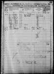
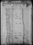
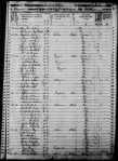
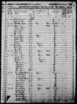
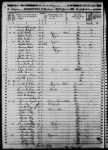
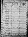
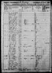
Here at Chequamegon History, though, we aren’t in the business broad overviews. We are going to drill down right into the data. We’ll comb through the 1850 federal census for La Pointe County and compare it with the 1860 data for La Pointe and Ashland Counties. Just for fun, we’ll compare both with the 1855 Wisconsin State Census for La Pointe County, then double back to the 1840 federal census for western St. Croix County. Ultimately, the hope is to help reveal how the population of the Chequamegon region viewed itself, and ultimately how that differed from mainstream America’s view. With luck, that will give us a framework for more stories like Amorin’s recent post on the killing of Louis Gurnoe.
Background
 Judge Daniel Harris Johnson of Prairie du Chien had no apparent connection to Lake Superior when he was appointed to travel northward to conduct the census for La Pointe County in 1850. The event made an impression on him. It gets a mention in his short memorial biography in the 1902 Proceedings of the State Bar Association.
Two years after statehood, Lake Superior’s connection to the rest of Wisconsin was hardly existent. This was long before Highways 51 and 53 were built, and commerce still flowed west to east. Any communication to or from Madison was likely to first go through Michigan via Mackinaw and Sault Ste. Marie, or through Minnesota Territory via St. Paul, Stillwater, and Sandy Lake. La Pointe County had been created in 1845, and when official business had to happen, a motley assortment of local residents who could read and write English: Charles Oakes, John W. Bell, Antoine Gordon, Alexis Carpentier, Julius Austrian, Leonard Wheeler, etc. would meet to conduct the business.
It is unclear how much notice the majority Ojibwe and French-patois speaking population took of this or of the census generally. To them, the familiar institutions of American power, the Fur Company and the Indian Agency, were falling apart at La Pointe and reorganizing in St. Paul with dire consequences for the people of Chequamegon. When Johnson arrived in September, the Ojibwe people of Wisconsin had already been ordered to remove to Sandy Lake in Minnesota Territory for their promised annual payments for the sale of their land. That fall, the government would completely botch the payment, and by February, hundreds of people in the Lake Superior Bands would be dead from starvation and disease.
So, Daniel Johnson probably found a great deal of distraction and anxiety among the people he was charged to count. Indians, thought of by the United States as uncivilized federal wards and citizens of their own nations, were typically not enumerated. However, as I wrote about in my last post, race and identity were complicated at La Pointe, and the American citizens of the Chequamegon region also had plenty to lose from the removal.
Madison, for its part, largely ignored this remote, northern constituency and praised the efforts to remove the Ojibwe from the state. It isn’t clear how much Johnson was paying attention to these larger politics, however. He had his own concerns:


House Documents, Volume 119, Part 1. U.S. Government Printing Office, 1859. Google Books.
So, in “that thinly settled and half civilized region,” Johnson only found a population of about 500, “exclusive of Indians.” He didn’t think 500 was a lot, but by some counts, that number would have seemed very high. Take the word of a European visitor to La Pointe:
Among 200 Indians, only a few white families live there. One of the boatmen gave us a name, with which we found Mr. Austrian.
And, from this Mr. Austrian, himself:
There were only about 6 white American inhabitants on the Island, about 50 Canadian Frenchmen who were married to squaws, and a number of full blooded Indians, among whom was chief Buffalo who was a descendant of chiefs & who was a good Indian and favorably regarded by the people.
~Joseph Austrian, Brother of Julius and La Pointe resident 1851-52
Who lived around La Pointe in 1850?
In her biography, William W. Warren: the Life, Letters, and Times of an Ojibwe Leader, Theresa Schenck describes the short life of an ambitious young man from La Pointe. William Whipple Warren (1825-1853) grew up on the Island speaking Ojibwe as his first language. His father was a Yankee fur trader from New York. His mother was a daughter of Michel and Madeline Cadotte. In his famous History of the Ojibways Warren describes the Ojibwe as people with whom he readily claims kinship, but he doesn’t write as if he is an Ojibwe person himself. However, he helped interpret the Treaty of 1847 which had definitively made him an Indian in the eyes of the United States (a fact he was willing to use for economic gain). Still, a few years later, when he became a legislator in Minnesota Territory he dismissed challenges to his claims of whiteness.
If he were alive today, Warren might get a chuckle out of this line from the South African comedian Trevor Noah.
People mocked me. Gave me names like mixed breed, half caste — I hate that term ‘half’. Why half? Why not double? Or twice as nice, I don’t know.
— Trevor Noah
William Warren did not see himself as quite the walking contradiction we might see him as today. He was a product of the time and place he came from: La Pointe. By 1850, he had left that place, but his sister and a few hundred of his cousins still lived there. Many of them were counted in the census.
What is Metis?
Half-breeds, Mixed-bloods, Frenchmen, Wiisakodewininiwag, Mitif, Creoles, Metis, Canadiens, Bois Brules, Chicots, French-of-the-country, etc.–at times it seems each of these means the same thing. At other times each has a specific meaning. Each is ambiguous in its own way. In 1850, roughly half the families in the Chequamegon area fit into this hard-to-define category.


Kohl, J. G. Kitchi-Gami: Wanderings around Lake Superior. London: Chapman and Hall, 1860. pg. 260-61.
We were accompanied on our trip throughout the lakes of western Canada by half-Indians who had paternal European blood in their veins. Yet so often, a situation would allow us to spend a night inside rather than outdoors, but they always asked us to choose to Irish camp outside with the Indians, who lived at the various places. Although one spoke excellent English, and they were drawn more to the great American race, they thought, felt, and spoke—Indian! ~Carl Scherzer
In describing William Warren’s people, Dr. Schenck writes,
Although the most common term for people of mixed Indian and European ancestry in the nineteenth century was “half-breed,” the term “mixed blood” was also used. I have chosen to use the latter term, which is considered less offensive, although biologically inaccurate, today. The term “métis” was not in usage at the time, except to refer to a specific group of people of mixed ancestry in the British territories to the north. “Wissakodewinini,” the word used by the Ojibwe, meant “burned forest men,” or bois brulés in French, so called because half-breeds were like the wood of a burned forest, which is often burned on one side, and light on the other (pg. xv).
Schenck is correct in pointing out that mixed-blood was far more commonly used in 19th-century sources than Metis (though the latter term did exist). She is also correct in saying that the term is more associated with Canada and the Red River Country. There is an additional problem with Metis, in that 21st-century members of the Wannabe Tribe have latched onto the term and use it, incorrectly, to refer to anyone with partial Native ancestry but with no affiliation to a specific Indian community.
That said, I am going to use Metis for two reasons. The first is that although blood (i.e. genetic ancestry) seemed to be ubiquitous topic of conversation in these communities, I don’t think “blood” is what necessarily what defined them. The “pure-blooded French Voyageur” described above by Kohl clearly saw himself as part of Metis, rather than “blanc” society. There were also people of fully-Ojibwe ancestry who were associated more with Metis society than with traditional Ojibwe society (see my post from April). As such, I find Metis the more versatile and accurate term, given that it means “mixed,” which can be just as applicable to a culture and lifestyle as it is to a genetic lineage.

One time Canadian pariah turned national hero, Louis Riel and his followers had cousins at La Pointe (Photo: Wikipedia)
The second reason I prefer Metis is precisely because of the way it’s used in Manitoba. Analogous to the mestizo nations of Latin America, Metis is not a way of describing any person with Native and white ancestry. The Metis consider themselves a creole-indigenous nation unto themselves, with a unique culture and history. This history, already two centuries old by 1850, represents more than simply a borrowed blend of two other histories. Finally, the fur-trade families of Red River came from Sault Ste. Marie, Mackinac, Grand Portage, and La Pointe. There were plenty of Cadottes, Defaults, Roys, Gurnoes, and Gauthiers among them. There was even a Riel family at La Pointe. They were the same nation
Metis and Ojibwe Identity in the American Era
When the 1847 Treaty of Fond du Lac “stipulated that the half or mixed bloods of the Chippewas residing with them shall be considered Chippewa Indians, and shall, as such, be allowed to participate in all annuities which shall hereafter be paid…” in many ways, it contradicted two centuries of tradition. Metis identity, in part, was dependent on not being Indian. They were a minority culture within a larger traditional Anishinaabe society. This isn’t to say that Metis people were necessarily ashamed of their Native ancestors–expressions of pride are much easier to find than expressions shame–they were just a distinct people. This was supposedly based in religion and language, but I would argue it came mostly from paternal lineage (originating from highly-patriarchal French and Ojibwe societies) and with the nature of men’s work. For women, the distinction between Ojibwe and Metis was less stark.
The imposition of American hegemony over the Chequamegon region was gradual. With few exceptions, the Americans who came into the region from 1820 to 1850 were adult men. If new settlers wanted families, they followed the lead of American and British traders and married Metis and Ojibwe women.
Still, American society on the whole did not have a lot of room for the racial ambiguity present in Mexico or even Canada. A person was “white” or “colored.” Race mixing was seen as a problem that affected particular individuals. It was certainly not the basis for an entire nation. In this binary, if Metis people weren’t going to be Indian, they had to be white.
The story of the Metis and American citizenship is complicated and well-studied. There is risk of overgeneralizing, but let’s suffice to say that in relation to the United States government, Metis people did feel largely entitled to the privileges of citizenship (synonymous with whiteness until 1865), as well as to the privileges of Ojibwe citizenship. There wasn’t necessarily a contradiction.
Whatever qualms white America might have had if they’d known about it, Metis people voted in American elections, held offices, and were counted by the census.
Ojibwe “Full-bloods” and the United States Census
Representatives and direct Taxes shall be apportioned among the several States which
may be included within this Union, according to their respective Numbers, which shall be determined by adding to the whole Number of free Persons, including those bound to Service for a Term of Years, and excluding Indians not taxed, three fifths of all other Persons. The actual Enumeration shall be made within three Years after the first Meeting of the Congress of the United States, and within every subsequent Term of ten Years, in such Manner as they shall by Law direct.~Excerpt from Article I Section II, U. S. Constitution
As I argued in the April post, our modern conception of “full-blood” and “mixed-blood” has been shaped by the “scientific” racism of the late 19th and early 20th centuries. The distinction, while very real in a cultural sense, was not well-grounded in biology.
The relationship of Indians (i.e. full-bloods or those living a traditional lifestyle) to American society and citizenship was possibly more contradictory then that of the Metis. In one sense, America saw Indians as foreigners on their own continent: either as enemies to be exterminated, or as domestic-dependent ward nations to be “protected.” The constitutional language about the census calls for slaves to be counted as three-fifths of a person. It says Indians shouldn’t be counted at all.
In another sense, however, the path to personhood in America was somewhat clearer for Indians than it was for African Americans. Many New England liberals saw exodus to Liberia as the only viable future for free blacks. These same voices felt that Indians could be made white if only they were separated from their religions, cultures, and tribal identities. In 1834, to avoid a second removal, the Brothertown Indians of Wisconsin petitioned congress for citizenship and the termination of collective title to their tribal lands. In 1839, their request was granted. In the eyes of the law, they had effectively become white. Other communities would follow suit. However, most Native people did not gain any form of American citizenship until 1924.
How did that play out for the Ojibwe people of Chequamegon, and how did it impact the 1850 census? Well, it’s complicated.
Race, the Census, and Classifying Households
The enumeration forms Daniel H. Johnson carried to La Pointe had more rows and columns than ever. The Seventh Census was the first to count everyone in the household by name (previous versions only listed the Head of Household with tally marks). It was also the first census to have a box for “color.” Johnson’s choices for color were “white,” “black,” and “mulatto,” forcing him to make some decisions.
He seems to have tried to follow the Indians not taxed clause strictly. 40-50% of households in the region were headed by a full-blood Ojibwe person, possibly only two of them were enumerated. You won’t find Chief Buffalo, Makadebinesi (Blackbird), Oshkinaawe, Omizhinaawe, Edawegiizhig, and their immediate families in the 1850 census. Jechiikwii’o (often called Little Buffalo) is not in the document, even though he was an early Catholic convert, dressed in “white” clothing, and counted more Metis Ojibwe among his followers than full-bloods. However, his son, Antoine Buffalo Sr. (Antoine Jachequaon) is counted. Antoine, along with George Day, were counted as white heads of household by the census, though it is unclear if they had any European ancestry (Sources conflict. If anyone has genealogical information for the Buffalo and Day families, feel free to comment on the post). A handful of individuals called full-bloods in other sources, were listed as white. This includes 90-year old Madeline Cadotte, Marie Bosquet, and possibly the Wind sisters (presumably descendants of Noodin, one of the St. Croix chiefs who became Catholic and relocated to La Pointe around this time). They were married to Metis men or lived in Metis households. All Metis were listed as white.
Johnson did invent new category for five other Ojibwe people: “Civilized Indian,” which he seemed to use arbitrarily. Though also living in Metis households, Mary Ann Cadotte, Osquequa Baszina, Marcheoniquidoque, Charlotte Houle, and Charles Loonsfoot apparently couldn’t be marked white the way Madeline Cadotte was. These extra notations by Johnson and other enumeration marshals across the country are why the Seventh Federal Census is sometimes referred to as the first to count Native Americans.

So, out of 470 individuals enumerated at La Pointe and Bad River (I’ve excluded Fond du Lac from my study) Johnson listed 465 (99%) as white. By no definition, contemporary or modern, was the Chequamegon area 99% white in 1850. The vast majority of names on the lines had Ojibwe ancestry, and as Chippewas of Lake Superior, were receiving annuities from the treaties.
There were a few white American settlers. The Halls had been at La Pointe for twenty years. The Wheelers were well-established at Odanah. Junius and Jane Welton had arrived by then. George Nettleton was there, living with a fellow Ohioan James Cadwell. The infamous Indian agent, John Watrous, was there preparing the disastrous Sandy Lake removal. Less easy to describe as American settlers, but clearly of European origins, Fr. Otto Skolla was the Catholic priest, and Julius Austrian was the richest man it town.
There were also a handful of American bachelors who had drifted into the region and married Metis women. These first-wave settlers included government workers like William VanTassel, entrepreneurs like Peter VanderVenter, adventurers with an early connection to the region like Bob Boyd and John Bell, and homesteaders like Ervin Leihy.
It is unclear how many of French-surnamed heads of household were Chicots (of mixed ancestry) and how many were Canadiens (of fully-French ancestry). My sense is that it is about half and half. Some of this can be inferred from birthplace (though a birthplace of Canada could indicate across the river at Sault Ste. Marie as easily it could a farm in the St. Lawrence Valley). Intense genealogical study of each family might provide some clarifications, but I am going to follow Kohl’s voyageurs and not worry too much about it. Whether it was important or not to Jean Baptiste Denomie and Alexis Carpentier that they had no apparent Indian ancestry and that they had come from “the true homeland” of Quebec, for all intents and purposes they had spent their whole adult lives in “the Upper Country,” and their families were “of the Country.” They were Catholic and spoke a form of French that wasn’t taught in the universities. American society would not see them as white in the way it saw someone like Sherman Hall as white.
So, by my reckoning, 435 of the 470 people counted at La Pointe (92.5%) were Metis, full-blood Ojibwe living in Metis households, or Canadians in Metis families. Adding the five “Civilized Indians” and the six Americans married into Metis families, the number rises to 95%. I am trying to track down accurate data on the of Indians not taxed (i.e. non-enumerated full-bloods) living at or near La Pointe/Bad River at this time. My best estimates would put it roughly the same as the number of Metis. So, when Johnson describes a land with a language and culture foreign to English-speaking Americans, he’s right.
Birthplace, Age, and Gender
Ethnic composition is not the only data worth looking at if we want to know what this area was like 169 years ago. The numbers both challenge and confirm assumptions of how things worked.
Let’s take mobility for example:

The young voyageur quoted by Kohl may have felt like he didn’t have a home other than en voyage, but 86% of respondents reported being born in Wisconsin. Except for ten missionary children, all of these were Metis or “Civilized Indian.” Wisconsin could theoretically mean Lac du Flambeau, Rice Lake, or even Green Bay, this but this number still seemed high to me. I’m guessing more than 14% of 21st-century Chequamegon residents were born outside the state, and 19th-century records are all about commerce, long-distance travel, and new arrivals in new lands. We have to remember that most of those records are coming from that 14%.
In September of 1850 the federal government was telling the Ojibwe of Wisconsin they needed to leave Wisconsin forever. How the Metis fit into the story of the Sandy Lake Tragedy has always been somewhat fuzzy, but this data would indicate that for a clear majority, it meant a serious uprooting.
For those born outside Wisconsin, more than two-thirds reported being born in Michigan, Canada, or Minnesota Territory. These are overwhelmingly Metis or in the case of Anglo-Canadians like Robert Morrin, heads of Metis households from areas with a fur-trade tradition. Only eighteen individuals reported being born in the eastern United States. Only three reported Europe.
I had more questions than assumptions about the gender and age breakdown of the population. Would there be more women than men because of the dangerous jobs done by men or would mortality from childbirth balance that out? Or maybe widows wouldn’t be counted if they returned to the wigwams of their mothers? How would newcomers skew the age and gender demographics of the area?
Let’s take a look:
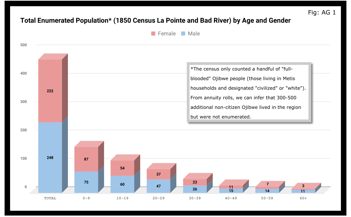
A quick glance at Figure AG 1 shows that the population skewed male 248-222 and skewed very young (61% under 20 years old). On the eve of Sandy Lake, the natural increase in the population seemed to be booming.

The hypotheses that women had higher mortality rates and were more likely to be undercounted looked good until we limit the data to the Wisconsin-born population. In Figure AG 2, we see that the male majority disappears entirely. The youthful trend, indicating large families and a growing population, continues with 66% of the Wisconsin-born population being under 20.

The male skew of the total population was entirely due to those born outside Wisconsin. This is not surprising given how much we’ve emphasized the number of men who came into the Lake Superior country to marry local women.
A look at the oldest residents in chart AG 2 and AG 3 hints at another story. Madeline Cadotte is the only Wisconsin-born person over seventy to be counted. The oldest men all came from Michigan and Canada. Why? My hypothesis is that between the fall of New France in 1759 and the establishment of Michel Cadotte’s post sometime around 1800, there wasn’t a large population or a very active fur trade around La Pointe proper. That meant Cadotte’s widow and other full bloods were the oldest locally-born residents in 1850. Their Metis contemporaries didn’t come over from the Soo or down from Grand Portage until 1810 or later.
Economics
Before the treaties, the economy of this area was built on two industries: foraging and trade. Life for Ojibwe people revolved around the seasonal harvest of fish, wild rice, game, maple sugar, light agriculture, and other forms of gathering food directly from the land. Trade did not start with the French, and even after the arrival of European goods into the region, the primary purpose of trade seemed to be for cementing alliances and for the acquisition of luxury goods and sacred objects. Richard White, Theresa Schenck, and Howard Paap have all challenged the myth of Ojibwe “dependence” on European goods for basic survival, and I find their arguments persuasive.
Trade, though, was the most important industry for Metis men and La Pointe was a center of this activity. The mid-19th century saw a steep decline in trade, however, to be replaced by a toxic cycle of debts, land sales, and annuity payments. The effects of this change on the Metis economy and society seem largely understudied. The fur trade though, was on its last legs. Again, the Austrian travel writer Carl Scherzer, who visited La Pointe in 1852:
After this discussion of the of the rates of the American Fur Company and its agents, we want to add some details about the men whose labor and time exerted such a great influence on the fate and culture of the Indian tribes. We wish to add a few explanatory words about the sad presence on La Pointe of the voyageurs or courriers du bois.
This peculiar class of people, which is like a vein of metal that suddenly disappears within the bedrock and reappears many hundreds of miles away under the same geological conditions, their light reaches the borders of the eastern Canadas. The British people, with their religion and customs, reappeared on the shores of these northern lakes only in 1808 with the Fur Company. For labor they drew on those who could carry their wares across the lakes and communicate with the Indians.
Many young men of adventurous natures left the old wide streets of Montreal and moved into the trackless primeval forests of the West. Young and strong as laborers, they soon started to adopt the lifestyle and language of the aborigines. They married with the Indians and inhabit small settlements scattered throughout those mighty lands which begin at Mackinow Island and come up the upper lake to the region of Minnesota. They almost all speak the Canadian patois along with the language of the Chippewas, the tribe with which they came into kinship. We found only a few, even among the younger generation, who understood English.
Since then, every day the population of the otherwise deserted shore of Lake Superior increases with the discovery of copper mines. The animals driven away by the whirlwind of civilization toward the west, attract the Indians with their sensitive guns, leaving La Pointe, abandoned by the Company for their headquarters at St. Paul in Minnesota. Most voyageurs left the island, having seen their business in ruins and lacking their former importance. Just a few families remain here, making a meager livelihood of hunting, fishing, and the occasional convoy of a few travelers led by business, science, or love of nature who purchase their limited resources.
From Scherzer’s description, two things are clear. It’s pretty clear from the flowery language of the Viennese visitor.Washington Irving and other Romantic-Era authors had already made the Voyageur into the stock stereotypical character we all know today. Th only change, though, is these days voyageurs are often depicted as representatives of white culture, but that’s a post for another time.
The second item, more pertinent to this post, is that a lot of voyageurs were out of work. This is especially relevant when we look at our census data. Daniel Johnson recorded the occupations of all males fifteen or over:
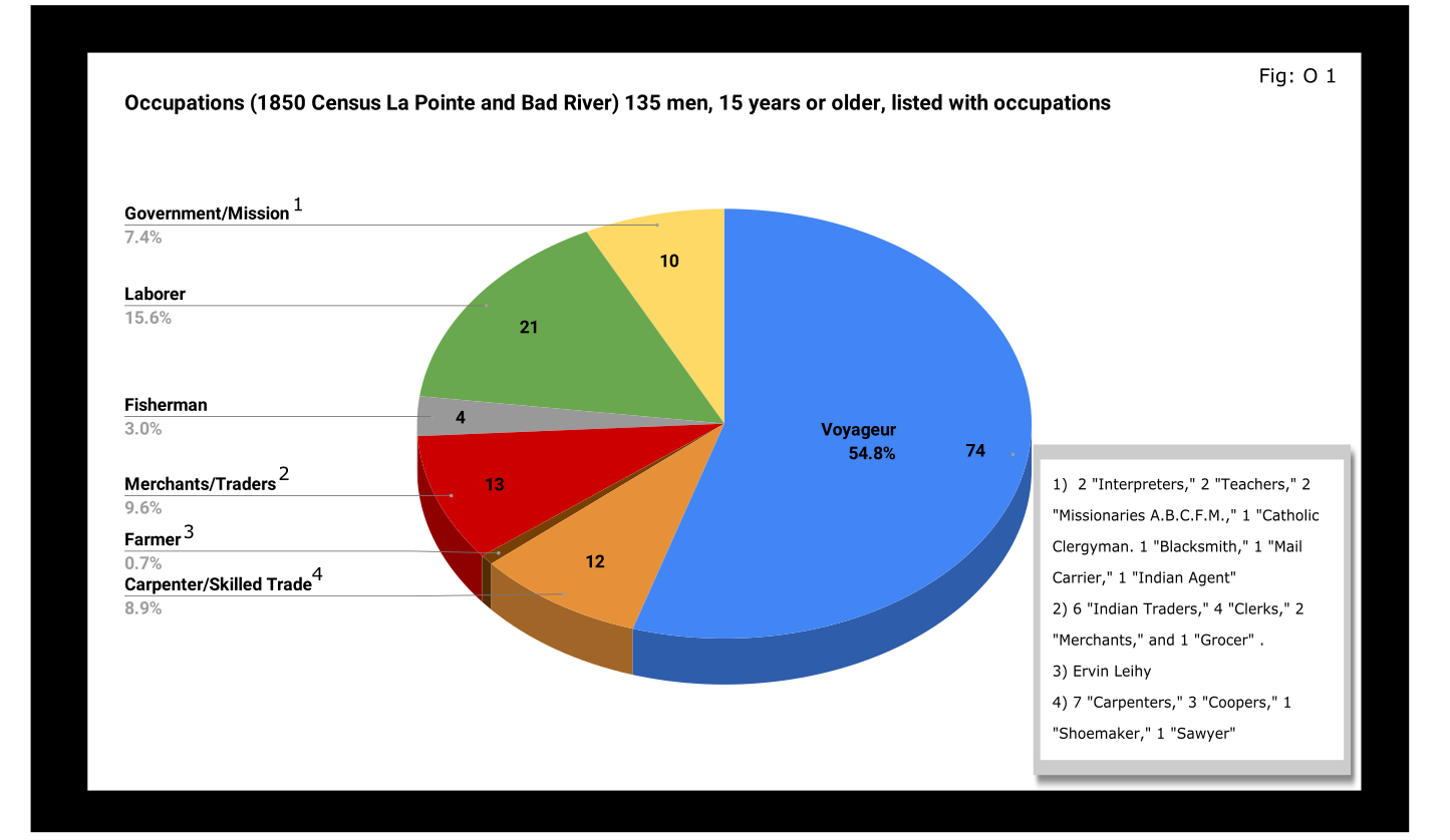
A full 55% of enumerated men fifteen and older still identified themselves as voyageurs in 1850. This included teenagers as well as senior citizens. All were from Metis households, though aside from farmer, all of the other occupation categories in Figure O 1 included Metis people.

A look at household sizes did not show voyageurs having to support significantly larger or smaller families when compared to the other occupation categories.
The other piece of economic data collected was value of real estate. Here we see some interesting themes:

If real estate is a good proxy for wealth in a farming community, it is an imperfect one in the Chequamegon area of 1850. If a voyageur had no home but the river and portage, then we might not expect him to put his coin into land and buildings. A teacher or Indian agent might draw a consistent salary but then live in supplied housing before moving on. With that caveat, let’s dig into the data.
Excluding the single farmer, men in the merchant/trader group controlled the most wealth in real estate, with Julius Austrian controlling as much as the other merchants combined. Behind them were carpenters and men with specific trades like cooper or shoemaker. Those who reported their occupation generally as “laborer” were not far behind the tradesmen. I suspect their real estate holdings may be larger and less varied than expected because of the number of sons and close relatives of Michel Cadotte Sr. who identified themselves as laborers. Government and mission employees held relatively little real estate, but the institutions they represented certainly weren’t lacking in land or power. Voyageurs come in seventh, just behind widows and ahead of fishermen of which there were only four in each category.
It is interesting, though, that the second and third richest men (by real estate) were both voyageurs, and voyageur shows a much wider range of households than some of the other categories: laborers in particular. With the number of teenagers calling themselves voyageurs, I suspect that the job still had more social prestige attached to it, in 1850, than say farmer or carpenter.
With hindsight we know that after 1854, voyageurs would be encouraged to take up farming and commercial fishing. It is striking, however, how small these industries were in 1850. Despite the American Fur Company’s efforts to push its Metis employees into commercial fishing in the 1830s, and knowing how many of the family names in Figure O 3 are associated with the industry, commercial fishing seemed neither popular nor lucrative in 1850. I do suspect, however, that the line between commercial and subsistence fishing was less defined in those days and that fishing in general was seen as falling back on the Indian gathering lifestyle. It wouldn’t be surprised if all these families were fishing alongside their Ojibwe relatives but didn’t really see fishing (or sugaring, etc.) as an occupation in the American sense.
Finally, it could not have escaped the voyageurs notice that while they were struggling, their former employers and their employers educated sons were doing pretty well. They also would have noticed that it was less and less from furs. Lump annuity payments for Ojibwe land sales brought large amounts of cash into the economy one day a year. It must have felt like piranhas with blood in the water. Alongside their full-blood cousins, Metis Ojibwe received these payments after 1847, but they had more of a history with money and capitalism. Whether to identify with the piranha or the prey would have depended on all sorts of decisions, opportunities and circumstances.
Education and Literacy
The census also collected data on education and literacy, asking whether children had attended school within the year, and whether adults over twenty could read and write. The history of white education efforts in this area are fairly well documented. The local schools in 1850 were run by the American Board of Commissioners of Foreign Missions (A.B.C.F.M.) at the La Pointe and Odanah missions, and an entire generation had come of age at La Pointe in the years since Rev. Sherman Hall first taught out of Lyman Warren’s storehouse in 1831. These Protestant ministers and teachers railed against the papists and heathens in their writings, but most of their students were Catholic or traditional Ojibwe in religion. Interestingly, much of the instruction was done in the Ojibwe language. Unfortunately, however, the census does not indicate the language an individual is literate in. I highly recommend The Ojibwe Journals of Edmund F. Ely, 1833-1849 if you are interested in these topics.
To start with, though, let’s look at how many people were going to school:

Thirty-nine students had gone to school in the previous year. There is a lot of sample-size noise in the data, but it seems like ages 7-11 (what we would call the upper-elementary years) were the prime years to attend school.
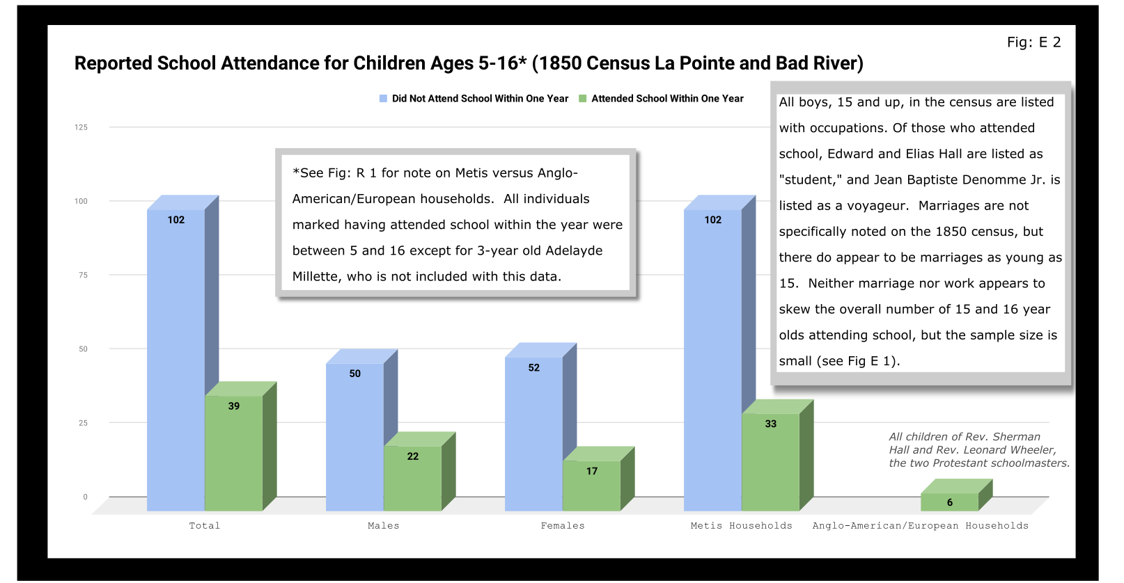
Overall, most children had not attended school within the year. Attendance rates were slightly higher for boys than for girls. White children, all from two missionary families, had a 100% attendance rate compared to 24% for the Metis and “Civilized Indian” children.
We should remember, however, that not attending school within the year is not the same as having never attended school. Twelve-year-old Eliza Morrin (later Morrison) is among the number that didn’t attend school, but she was educated enough to write her memoirs in English, which was her second language. They were published in 2002 as A Little History of My Forest Life, a fascinating account of Metis life in the decades following 1854.
Eliza’s parents were among the La Pointe adults who could read and write. Her aunt, uncle, and adult cousins in the neighboring Bosquet (Buskey) house were not. Overall, just over half of adults over 20 were illiterate without a significant gender imbalance. Splitting by birthplace, however, shows the literacy rate for Wisconsin-born (i.e. Metis and “Civilized Indian”) was only 30%, down from the overall male literacy rate of 48%. For Wisconsin-born women, the drop is only three points, from 47% to 44%. This suggests Metis women were learning to read while their husbands and brothers (perhaps en voyage) were not.

And this is exactly what the data say when we split by occupation. The literacy rate for voyageurs was only 13%. This beats fisherman–all four were illiterate–but lagged far behind all other types of work.
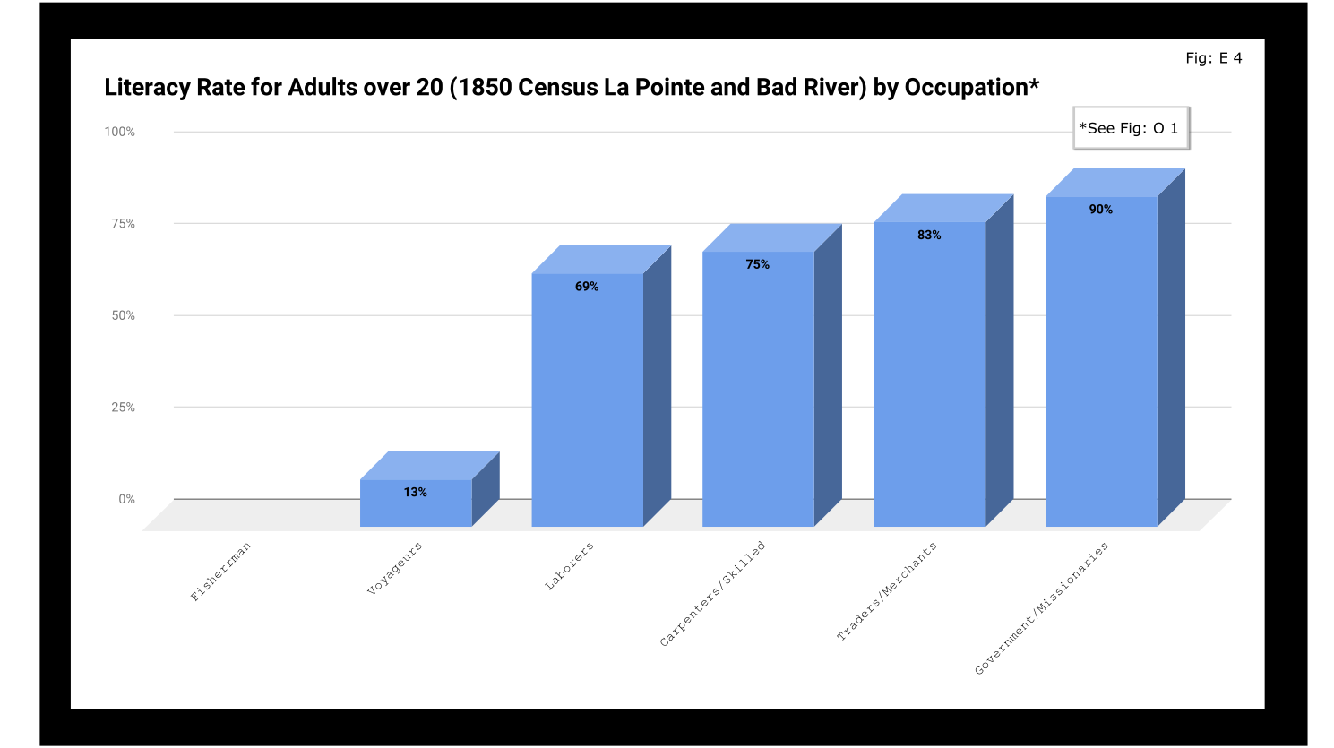
If education was going to be a factor in the economic mobility of unemployed voyageurs, the trends weren’t looking good.
Odds and Ends
Two marriages were reported as occurring in the year previous to the census: Peter and Caroline Vanderventer and Pierre and Marguerite Robideaux (ak.a. Peter and Margaret Rabideaux). Though married, however, Caroline was not living with her husband, a 32-year old grocer from New York. She (along with their infant daughter) was still in the home of her parents Benjamin and Margaret Moreau (Morrow). The Vanderventers eventually built a home together and went on to have several more children. It appears their grandson George Vanderventer married Julia Rabideaux, the granddaughter of Peter and Margaret.
I say appears in the case of George and Julia, because Metis genealogy can be tricky. It requires lots of double and triple checking. Here’s what I came across when I once tried to find an unidentified voyageur known only as Baptiste:

Sometimes it feels like for every Souverain Denis or Argapit Archambeau, there are at least 15 Jean-Baptiste Cadottes, 12 Charles Bresettes, 10 Francois Belangers and 8 Joseph DeFoes. Those old Canadian names had a way of persisting through the generations. If you were a voyageur at La Pointe in 1850, there was nearly a 30% chance your name was Jean-Baptiste. To your friends you might be John-Baptist, Shabadis, John, JB, or Battisens, and you might be called something else entirely when the census taker came around.
The final column on Daniel Johnson’s census asked whether the enumerated person was “deaf and dumb, blind, insane, idiotic, pauper, or convict.” 20 year-old Isabella Tremble, living in the household of Charles Oakes, received the unfortunate designation of idiotic. 26-year-old Francois DeCouteau did not have a mark in that column, but had “Invalid” entered in for his occupation. It’s fair to say we’ve made some progress in the treatment of people with disabilities.
Final Thoughts
I am not usually a numbers person when it comes to history. I’ll always prefer a good narrative story, to charts, tables, and cold numbers. Sometimes, though, the numbers help tell the story. They can help us understand why when Louis Gurnoe was killed, no one was held accountable. At the very least, they can help show us that the society he lived in was under significant stress, that the once-prestigious occupation of his forefathers would no longer sustain a family, and that the new American power structure didn’t really understand or care who his people were.
Ultimately, the census is about America describes itself. From the very beginning, it’s never been entirely clear if in E. pluribus unum we should emphasize the pluribus or the unum. We struggled with that in 1850, and we still struggle today. To follow the Department of Commerce v. New York citizenship case, I recommend Scotusblog. For more census posts about this area in the 19th century, keep following Chequamegon History.
Sources, Data, and Further Reading
-
Paap, Howard D. Red Cliff, Wisconsin a History of an Ojibwe Community ; Volume 1 The Earliest Years: the Origin to 1854. North Star Press of St. Cloud, Inc., 1854.
-
Satz, Ronald N. Chippewa Treaty Rights: the Reserved Rights of Wisconsin’s Chippewa Indians in Historical Perspective. University of Wisconsin Press, 1997.
-
Original Census Act of May 23, 1850 (includes form and instructions for marshals). (PDF)
-
Compiled data spreadsheets (Google Drive Folder) I’ll make these a lot more user friendly in future census posts. By the time it occurred to me that I should include my tables in this post, most of them were already done in tally marks on scrap paper.
-
Finally, these are the original pages, scanned from microfilm by FamilySearch.com. I included the image for Fond du Lac (presumably those living on the Wisconsin side of the St. Louis River) even though I did not include it in any of the data above.
-

- Bad River
-
- Fond du Lac (not included in above data)


Historic Sites on Chequamegon Bay
July 25, 2016
By Amorin Mello
Historical Sites on Chequamegon Bay was originally published in Collections of the State Historical Society of Wisconsin: Volume XIII, by Reuben Gold Thwaites, 1895, pages 426-440.
HISTORIC SITES ON CHEQUAMEGON BAY.1
—
BY CHRYSOSTOM VERWYST, O.S.F.
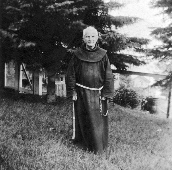
Reverend Chrysostome Verwyst, circa 1918.
~ Wisconsin Historical Society
One of the earliest spots in the Northwest trodden by the feet of white men was the shore of Chequamegon Bay. Chequamegon is a corrupt form of Jagawamikong;2 or, as it was written by Father Allouez in the Jesuit Relation for 1667, Chagaouamigong. The Chippewas on Lake Superior have always applied this name exclusively to Chequamegon Point, the long point of land at the entrance of Ashland Bay. It is now commonly called by whites, Long Island; of late years, the prevailing northeast winds have caused Lake Superior to make a break through this long, narrow peninsula, at its junction with the mainland, or south shore, so that it is in reality an island. On the northwestern extremity of this attenuated strip of land, stands the government light-house, marking the entrance of the bay.

William Whipple Warren, circa 1851.
~ Commons.Wikimedia.org
W. W. Warren, in his History of the Ojibway Nation3, relates an Indian legend to explain the origin of this name. Menabosho, the great Algonkin demi-god, who made this earth anew after the deluge, was once hunting for the great beaver in Lake Superior, which was then but a large beaver-pond. In order to escape his powerful enemy, the great beaver took refuge in Ashland Bay. To capture him, Menabosho built a large dam extending from the south shore of Lake Superior across to Madelaine (or La Pointe) Island. In doing so, he took up the mud from the bottom of the bay and occasionally would throw a fist-full into the lake, each handful forming an island, – hence the origin of the Apostle Islands. Thus did the ancient Indians, the “Gété-anishinabeg,” explain the origin of Chequamegon Point and the islands in the vicinity. His dam completed, Menabosho started in pursuit of the patriarch of all the beavers ; he thinks he has him cornered. But, alas, poor Menabosho is doomed to disappointment. The beaver breaks through the soft dam and escapes into Lake Superior. Thence the word chagaouamig, or shagawamik (“soft beaver-dam”), – in the locative case, shagawamikong (“at the soft beaver-dam”).
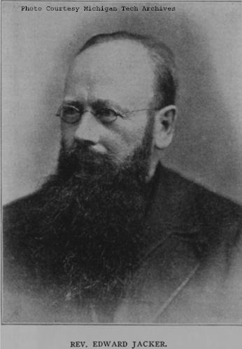
Reverend Edward Jacker
~ FindAGrave.com
Rev. Edward Jacker, a well-known Indian scholar, now deceased, suggests the following explanation of Chequamegon: The point in question was probably first named Jagawamika (pr. shagawamika), meaning “there are long, far-extending breakers;” the participle of this verb is jaiagawamikag (“where there are long breakers”). But later, the legend of the beaver hunt being applied to the spot, the people imagined the word amik (a beaver) to be a constituent part of the compound, and changed the ending in accordance with the rules of their language, – dropping the final a in jagawamika, making it jagawamik, – and used the locative case, ong (jagawamikong), instead of the participial form, ag (jaiagawamikag).4
The Jesuit Relations apply the Indian name to both the bay and the projection of land between Ashland Bay and Lake Superior. our Indians, however, apply it exclusively to this point at the entrance of Ashland Bay. It was formerly nearly connected with Madelaine (La Pointe) Island, so that old Indians claim a man might in early days shoot with a bow across the intervening channel. At present, the opening is about two miles wide. The shores of Chequamegon Bay have from time immemorial been the dwelling-place of numerous Indian tribes. The fishery was excellent in the bay and along the adjacent islands. The bay was convenient to some of the best hunting grounds of Northern Wisconsin and Minnesota. The present writer was informed, a few years ago, that in Douglas county alone 2,500 deer had been killed during one short hunting season.5 How abundant must have been the chase in olden times, before the white had introduced to this wilderness his far-reaching fire-arms! Along the shores of our bay were established at an early day fur-trading posts, where adventurous Frenchmen carried on a lucrative trade with their red brethren of the forest, being protected by French garrisons quartered in the French fort on Madelaine Island.
From Rev. Henry Blatchford, an octogenarian, and John B. Denomie (Denominé), an intelligent half-breed Indian of Odanah, near Ashland, the writer has obtained considerable information as to the location of ancient and modern aboriginal villages on the shores of Chequamegon Bay. Following are the Chippewa names of the rivers and creeks emptying into the bay, where there used formerly to be Indian villages:

Charles Whittlesey documented several pictographs along the Bad River.
Mashki-Sibi (Swamp River, misnamed Bad River): Up this river are pictured rocks, now mostly covered with earth, on which in former times Indians engraved in the soft stone the images of their dreams, or the likenesses of their tutelary manitous. Along this river are many maple-groves, where from time immemorial they have made maple-sugar.
Makodassonagani-Sibi (Bear-trap River), which emptties into the Kakagon. The latter seems in olden times to have been the regular channel of Bad River, when the Bad emptied into Ashland Bay, instead of Lake Superior, as it now does. Near the mouth of the Kakagon are large wild-rice fields, where the Chippewas annually gather, as no doubt did their ancestors, great quantities of wild rice (Manomin). By the way, wild rice is very palatable, and the writer and his dusky spiritual children prefer it to the rice of commerce, although it does not look quite so nice.
Bishigokwe-Sibiwishen is a small creek, about six miles or so east of Ashland. Bishigokwe means a woman who has been abandoned by her husband. In olden times, a French trader resided at the mouth of this creek. He suddenly disappeared, – whether murdered or not, is not known. His wife continued to reside for many years at their old home, hence the name.
Nedobikag-Sibiwishen is the Indian name for Bay City Creek, within the limits of Ashland. Here Tagwagané, a celebrated Indian chief of the Crane totem, used occasionally to reside. Warren6 gives us a speech of his, at the treaty of La Pointe in 1842. This Tagwagané had a copper plate, an heirloom handed down in his family from generation to generation, on which were rude indentations and hieroglyphics denoting the number of generations of that family which had passed away since they first pitched their lodges at Shagawamikong and took possession of the adjacent country, including Madelaine Island. From this original mode of reckoning time, Warren concludes that the ancestors of said family first came to La Pointe circa A. D. 1490.

Detail of “Ici était une bourgade considerable” from Carte des lacs du Canada by Jacques-Nicolas Bellin, 1744.
~ Wisconsin Historical Society
Metabikitigweiag-Sibiwishen is the creek between Ashland and Ashland Junction, which runs into Fish Creek a short distance west of Ashland. At the junction of these two creeks and along their banks, especially on the east bank of Fish Creek, was once a large and populous Indian village of Ottawas, who there raised Indian corn. It is pointed out on N. Bellin’s map (1744)7, with the remark, Ici était une bourgade considerable (“here was once a considerable village”). We shall hereafter have occasion to speak of this place. The soil along Fish Creek is rich, formed by the annual overflowage of its water, leaving behind a deposit of rich, sand loam. There a young growth of timber along the right bank between the bay and Ashland Junction, and the grass growing underneath the trees shows that it was once a cultivated clearing. It was from this place that the trail left the bay, leading to the Chippewa River country. Fish Creek is called by the Indians Wikwedo-Sibiwishen, which means “Bay Creek,” from wikwed, Chippewa for bay; hence the name Wikwedong, the name they gave to Ashland, meaning “at the bay.”

Whittlesey Creek (National Wildlife Refuge) was named after Asaph Whittlesey, brother of Charles Whittlesey. Photo of Asaph, circa 1860.
~ Wisconsin Historical Society
According to Blatchford, there was formerly another considerable village at the mouth of Whittlesey’s Creek, called by the Indians Agami-Wikwedo-Sibiwishen, which signifies “a creek on the other side of the bay,” from agaming (on the other side of a river, or lake), wikwed (a bay), and sibiwishen (a creek). I think that Fathers Allouez and Marquette had their ordinary abode at or near this place, although Allouez seems also to have resided for some time at the Ottawa village up Fish Creek.
A short distance from Whittlesey’s Creek, at the western bend of the bay, where is now Shore’s Landing, there used to be a large Indian village and trading-post, kept by a Frenchman. Being at the head of the bay, it was the starting point of the Indian trail to the St. Croix country. Some years ago the writer dug up there, an Indian mound. The young growth of timber at the bend of the bay, and the absence of stumps, indicate that it had once been cleared. At the foot of the bluff or bank, is a beautiful spring of fresh water. As the St. Croix country was one of the principal hunting grounds of the Chippewas and Sioux, it is natural there should always be many living at the terminus of the trail, where it struck the bay.
From this place northward, there were Indian hamlets strung along the western shore of the bay. Father Allouez mentions visiting various hamlets two, three, or more (French) leagues away from his chapel. Marquette mentions five clearings, where Indian villages were located. At Wyman’s place, the writer some years ago dug up two Indian mounds, one of which was located on the very bank of the bay and was covered with a large number of boulders, taken from the bed of the bay. In this mound were found a piece of milled copper, some old-fashioned hand-made iron nails, the stem of a clay pipe, etc. The objects were no doubt relics of white men, although Indians had built the mound itself, which seemed like a fire-place shoveled under, and covered with large boulders to prevent it from being desecrated.
Boyd’s Creek is called in Chippewa, Namebinikanensi-Sibiwishen, meaning “Little Sucker Creek.” A man named Boyd once resided there, married to an Indian woman. He was shot in a quarrel with another man. One of his sons resides at Spider Lake, and another at Flambeau Farm, while two of his grand-daughters live at Lac du Flambeau.
Further north is Kitchi-Namebinikani-Sibiwishen, meaning “Large Sucker Creek,” but whites now call it Bonos Creek. These two creeks are not far apart, and once there was a village of Indians there. It was noted as a place for fishing at a certain season of the year, probably in spring, when suckers and other fish would go up these creeks to spawn.
At Vanderventer’s Creek, near Washburn, was the celebrated Gigito-Mikana, or “council-trail,” so called because here the Chippewas once held a celebrated council; hence the Indian name Gigito-Mikana-Sibiwishen, meaning “Council-trail Creek.” At the mouth of this creek, there was once a large Indian village.
There used also to be a considerable village between Pike’s Bay and Bayfield. It was probably there that the celebrated war chief, Waboujig, resided.
John Baptiste Denomie
~ Noble Lives of a Noble Race, A Series of Reproductions by the Pupils of Saint Mary’s, Odanah, Wisconsin, page 213-217.
There was once an Indian village where Bayfield now stands, also at Wikweiag (Buffalo Bay), at Passabikang, Red Cliff, and on Madelaine Island. The writer was informed by John B. Denomie, who was born on the island in 1834, that towards Chabomnicon Bay (meaning “Gooseberry Bay”) could long ago be seen small mounds or corn-hills, now overgrown with large trees, indications of early Indian agriculture. There must have been a village there in olden times. Another ancient village was located on the southwestern extremity of Madelaine Island, facing Chequamegon Point, where some of their graves may still be seen. It is also highly probable that there were Indian hamlets scattered along the shore between Bayfield and Red Cliff, the most northern mainland of Wisconsin. There is now a large, flourishing Indian settlement there, forming the Red Cliff Chippewa reservation. There is a combination church and school there at present, under the charge of the Franciscan Order. Many Indians also used to live on Chequamegon Point, during a great part of the year, as the fishing was good there, and blueberries were abundant in their season. No doubt from time immemorial Indians were wont to gather wild rice at the mouth of the Kakagon, and to make maple sugar up Bad River.

Illustration from The Story of Chequamegon Bay, Collections of the State Historical Society of Wisconsin: Volume XIII, 1895, page 419.
We thus see that the Jesuit Relations are correct when they speak of many large and small Indian villages (Fr. bourgades) along the shores of Chequamegon Bay. Father Allouez mentions two large Indian villages at the head of the bay – the one an Ottawa village, on Fish Creek; the other a Huron, probably between Shore’s Landing and Washburn. Besides, he mentions smaller hamlets visited by him on his sick-calls. Marquette says that the Indians lived there in five clearings, or villages. From all this we see that the bay was from most ancient times the seat of a large aboriginal population. Its geographical position towards the western end of the great lake, its rich fisheries and hunting grounds, all tended to make it the home of thousands of Indians. Hence it is much spoken of by Perrot, in his Mémoire, and by most writers on the Northwest of the last century. Chequamegon Bay, Ontonagon, Keweenaw Bay, and Sault Ste. Marie (Baweting) were the principal resorts of the Chippewa Indians and their allies, on the south shore of Lake Superior.
“Front view of the Radisson cabin, the first house built by a white man in Wisconsin. It was built between 1650 and 1660 on Chequamegon Bay, in the vicinity of Ashland. This drawing is not necessarily historically accurate.”
~ Wisconsin Historical Society
The first white men on the shores of Chequamegon Bay were in all probability Groseilliers and Radisson. They built a fort on Houghton Point, and another at the head of the bay, somewhere between Whittlesey’s Creek and Shore’s Landing, as in some later paper I hope to show from Radisson’s narrative.8 As to the place where he shot the bustards, a creek which led him to a meadow9, I think this was Fish Creek, at the mouth of which is a large meadow, or swamp.10
After spending six weeks in the Sioux country, our explorers retraced their steps to Chequamegon Bay, arriving there towards the end of winter. They built a fort on Houghton Point. The Ottawas had built another fort somewhere on Chequamegon Point. In travelling towards this Ottawa fort, on the half-rotten ice, Radisson gave out and was very sick for eight days; but by rubbing his legs with hot bear’s oil, and keeping them well bandaged, he finally recovered. After his convalescence, our explorers traveled northward, finally reaching James Bay.
The next white men to visit our bay were two Frenchmen, of whom W. W. Warren says:11
“One clear morning in the early part of winter, soon after the islands which are clustered in this portion of Lake Superior, and known as the Apostles, had been locked in ice, a party of young men of the Ojibways started out from their village in the Bay of Shag-a-waum-ik-ong [Chequamegon], to go, as was customary, and spear fish through holes in the ice, between the island of La Pointe and the main shore, this being considered as the best ground for this mode of fishing. While engaged in this sport, they discovered a smoke arising from a point of the adjacent island, toward its eastern extremity.
“The island of La Pointe was then totally unfrequented, from superstitious fears which had but a short time previous led to its total evacuation by the tribe, and it was considered an act of the greatest hardihood for any one to set foot on its shores. The young men returned home at evening and reported the smoke which they had seen arising from the island, and various were the conjectures of the old people respecting the persons who would dare to build a fire on the spirit-haunted isle. They must be strangers, and the young men were directed, should they again see the smoke, to go and find out who made it.
“Early the next morning, again proceeding to their fishing-ground, the young men once more noticed the smoke arising from the eastern end of the unfrequented island, and, again led on by curiosity, they ran thither and found a small log cabin, in which they discovered two white men in the last stages of starvation. The young Ojibways, filled with compassion, carefully conveyed them to their village, where being nourished with great kindness, their lives were preserved.
“These two white men had started from Quebec during the summer with a supply of goods, to go and find the Ojibways who every year had brought rich packs of beaver to the sea-coast, notwithstanding that their road was barred by numerous parties of the watchful and jealous Iroquois. Coasting slowly up the southern shores of the Great Lake late in the fall, they had been driven by the ice on to the unfrequented island, and not discovering the vicinity of the Indian village, they had been for some time enduring the pangs of hunger. At the time they were found by the young Indians, they had been reduced to the extremity of roasting and eating their woolen cloth and blankets as the last means of sustaining life.
“Having come provided with goods they remained in the village during the winter, exchanging their commodities for beaver skins. They ensuing spring a large number of the Ojibways accompanied them on their return home.
“From close inquiry, and judging from events which are said to have occurred about this period of time, I am disposed to believe that this first visit by the whites took place about two hundred years ago [Warren wrote in 1852]. It is, at any rate, certain that it happened a few years prior to the visit of the ‘Black-gowns’ [Jesuits] mentioned in Bancroft’s History, and it is one hundred and eighty-four years since this well-authenticated occurrence.”
So far Warren; he is, however, mistaken as to the date of the first black-gown’s visit, which was not 1668 but 1665.

Portrayal of Claude Allouez
~ National Park Service
The next visitors to Chequamegon Bay were Père Claude Allouez and his six companions in 1665. We come now to a most interesting chapter in the history of our bay, the first formal preaching of the Christian religion on its shores. For a full account of Father Allouez’s labors here, the reader is referred to the writer’s Missionary Labors of Fathers Marquette, Allouez, and Ménard in the Lake Superior Region. Here will be given merely a succinct account of their work on the shores of the bay. To the writer it has always been a soul-inspiring thought that he is allowed to tread in the footsteps of those saintly men, who walked, over two hundred years ago, the same ground on which he now travels; and to labor among the same race for which they, in starvation and hardship, suffered so much.
In the Jesuit Relation for 1667, Father Allouez thus begins the account of his five years’ labors on the shores of our bay:
“On the eight of August of the year 1665, I embarked at Three Rivers with six Frenchmen, in company with more than four hundred Indians of different tribes, who were returning to their country, having concluded the little traffic for which they had come.”
Marquis Alexandre de Prouville de Tracy
~ Wikipedia.org
His voyage into the Northwest was one of the great hardships and privations. The Indians willingly took along his French lay companions, but him they disliked. Although M. Tracy, the governor of Quebec, had made Father Allouez his ambassador to the Upper Algonquins, thus to facilitate his reception in their country, nevertheless they opposed him accompanying them, and threatened to abandon him on some desolate island. No doubt the medicine-men were the principal instigators of this opposition. He was usually obliged to paddle like the rest, often till late in the night, and that frequently without anything to eat all day.
“On a certain morning,” he says, “a deer was found, dead since four or five days. It was a lucky acquisition for poor famished beings. I was offered some, and although the bad smell hindered some from eating it, hunger made me take my share. But I had in consequence an offensive odor in my mouth until the next day. In addition to all these miseries we met with, at the rapids I used to carry packs as large as possible for my strength; but I often succumbed, and this gave our Indians occasion to laugh at me. They used to make fun of me, saying a child ought to be called to carry me and my baggage.”
August 24, they arrived at Lake Huron, where they made a short stay; then coasting along the shores of that lake, they arrived at Sault Ste. Marie towards the beginning of September. September 2, they entered Lake Superior, which the Father named Lake Tracy in acknowledgement of the obligations which the people of those upper countries owed to the governor. Speaking of his voyage on Lake Superior, Father Allouez remarks:
“Having entered Lake Tracy, we were engaged the whole month of September in coasting along the south shore. I had the consolation of saying holy mass, as I now found myself alone with our Frenchmen, which I had not been able to do since my departure from Three Rivers. * * * We afterwards passed the bay, called by the aged, venerable Father Ménard, Sait Theresa [Keweenaw] Bay.”
Speaking of his arrival at Chequamegon Bay, he says:
“After having traveled a hundred and eighty leagues on the south shore of Lake Tracy, during which our Saviour often deigned to try our patience by storms, hunger, daily and nightly fatigues, we finally, on the first day of October, 1665, arrived at Chagaouamigong, for which place we had sighed so long. It is a beautiful bay, at the head of which is situated the large village of the Indians, who there cultivate fields of Indian corn and do not lead a nomadic life. There are at this place men bearing arms, who number about eight hundred; but these are gathered together from seven different tribes, and live in peacable community. This great number of people induced us to prefer this place to all others for our ordinary abode, in order to attend more conveniently to the instruction of these heathens, to put up a chapel there and commence the functions of Christianity.”
Further on, speaking of the site of his mission and its chapel, he remarks:
“The section of the lake shore, where we have settled down, is between two large villages, and is, as it were, the center of all the tribes of these countries, because the fishing here is very good, which is the principal source of support of these people.”
To locate still more precisely the exact site of his chapel, he remarks, speaking of the three Ottawa clans (Outaouacs, Kiskakoumacs, and Outaoua-Sinagonc):
“I join these tribes [that is, speaks of them as one tribe] because they had one and the same language, which is the Algonquin, and compose one of the same village, which is opposite that of the Tionnontatcheronons [Hurons of the Petun tribe] between which villages we reside.”
But where was that Ottawa village? A casual remark of Allouez, when speaking of the copper mines of Lake Superior, will help us locate it.
“It is true,” says he, “on the mainland, at the place where the Outaouacs raise Indian corn, about half a league from the edge of the water, the women have sometimes found pieces of copper scattered here and there, weighing ten, twenty or thirty pounds. It is when digging into the sand to conceal their corn that they make these discoveries.”
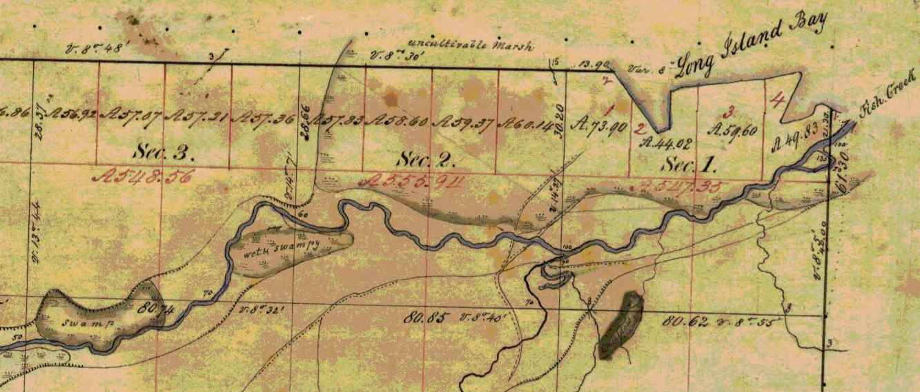
Detail of Fish Creek from Township 47 North Range 5 West.
~ Wisconsin Public Land Survey Records
Allouez evidently means Fish Creek. About a mile or so from the shore of the bay, going up this creek, can be seen traces of an ancient clearing on the left-hand side, where Metabikitigweiag Creeek empties into Fish Creek, about half-way between Ashland and Ashland Junction. The writer examined the locality about ten years ago. This then is the place where the Ottawas raised Indian corn and had their village. In Charlevoix’s History of New France, the same place is marked as the site of an ancient large village. The Ottawa village on Fish Creek appears to have been the larger of the two at the head of Chequamegon Bay, and it was there Allouez resided for a time, until he was obliged to return to his ordinary dwelling place, “three-fourths of a league distant.” This shows that the ordinary abode of Father Allouez and Marquette, the site of their chapel, was somewhere near Whittlesey’s Creek or Shore’s Landing. The Huron village was most probably along the western shore of the bay, between Shore’s Landing and Washburn.

Detail of Ashland next to an ancient large village (unmarked) in Township 47 North Range 4 West.
~ Wisconsin Public Land Survey Records
Father Allouez did not confine his apostolic labors to the two large village at the head of the bay. He traveled all over the neighborhood, visiting the various shore hamlets, and he also spent a month at the western extremity of Lake Superior – probably at Fond du Lac – where he met with some Chippewas and Sioux. In 1667 he crossed the lake, most probably from Sand Island, in a frail birch canoe, and visited some Nipissirinien Christians at Lake Nepigon (Allimibigong). The same year he went to Quebec with an Indian flotilla, and arrived there on the 3d of August, 1667. After only two days’ rest he returned with the same flotilla to his far distant mission on Chequamegon Bay, taking along Father Louis Nicholas. Allouez contained his missionary labors here until 1669, when he left to found St. Francis Xavier mission at the head of Green Bay. His successor at Chequamegon Bay was Father James Marquette, discoverer and explorer of the Mississippi. Marquette arrived here September 13, 1669, and labored until the spring of 1671, when he was obliged to leave on account of the war which had broken out the year before, between the Algonquin Indians at Chequamegon Bay and their western neighbors, the Sioux.
1 – See ante, p. 419 for map of the bay. – ED.
2 – In writing Indian names, I follow Baraga’s system of orthography, giving the French quality to both consonants and vowels.
3 – Minn. Hist. Colls., v. – ED.
4 – See ante, p. 399, note. – ED.
5 – See Carr’s interesting and exhaustive article, “The Food of Certain American Indians,” in Amer. Antiq. Proc., x., pp. 155 et seq. – ED.
6 – Minn. Hist. Colls., v. – ED.
7 – In Charlevoix’s Nouvelle France. – ED.
8 – See Radisson’s Journal, in Wis. Hist. Colls., xi. Radisson and Groseilliers reached Chequamegon Bay late in the autumn of 1661. – ED.
9 – Ibid., p. 73: “I went to the wood some 3 or 4 miles. I find a small brooke, where I walked by ye sid awhile, wch brought me into meddowes. There was a poole, where weare a good store of bustards.” – ED.
10 – Ex-Lieut. Gov. Sam. S. Fifield, of Ashland, writes me as follows:
“After re-reading Radisson’s voyage to Bay Chewamegon, I am satisfied that it would by his description be impossible to locate the exact spot of his camp. The stream in which he found the “pools,” and where he shot fowl, is no doubt Fish Creek, emptying into the bay at its western extremity. Radisson’s fort must have been near the head of the bay, on the west shore, probably at or near Boyd’s Creek, as there is an outcropping of rock in that vicinity, and the banks are somewhat higher than at the head of the bay, where the bottom lands are low and swampy, forming excellent “duck ground” even to this day. Fish Creek has three outlets into the bay, – one on the east shore or near the east side, one central, and one near the western shore; for full two miles up the stream, it is a vast swamp, through which the stream flows in deep, sluggish lagoons. Here, in the early days of American settlement, large brook trout were plenty; and even in my day many fine specimens have been taken from these “pools.” Originally, there was along these bottoms a heavy elm forest, mixed with cedar and black ash, but it has now mostly disappeared. An old “second growth,” along the east side, near Prentice Park, was evidently once the site of an Indian settlement, probably of the 18th century.
“I am of the opinion that the location of Allouez’s mission was at the mouth of Vanderventer’s Creek, on the west shore of the bay, near the present village of Washburn. It was undoubtedly once the site of a large Indian village, as was the western part of the present city of Ashland. When I came to this locality, nearly a quarter of a century ago, “second growth” spots could be seen in several places, where it was evident that the Indians had once had clearings for their homes. The march of civilization has obliterated these landmarks of the fur-trading days, when the old French voyageurs made the forest-clad shores of our beautiful bay echo with their boat songs, and when resting from their labors sparked the dusky maidens in their wigwams.”
Rev. E. P. Wheeler, of Ashland, a native of Madelaine Island, and an authority on the region, writes me:
“I think Radisson’s fort was at the mouth of Boyd’s Creek, – at least that place seems for the present to fulfill the conditions of his account. it is about three or four miles from here to Fish Creek valley, which leads, when followed down stream, to marshes ‘meadows, and a pool.’ No other stream seems to have the combination as described. Boyd’s Creek is about four miles from the route he probably took, which would be by way of the plateau back from the first level, near the lake. Radisson evidently followed Fish Creek down towards the lake, before reaching the marshes. This condition is met by the formation of the creek, as it is some distance from the plateau through which Fish Creek flows to its marshy expanse. Only one thing makes me hesitate about coming to a final decision, – that is, the question of the age of the lowlands and formations around Whittlesey Creek. I am going to go over the ground with an expert geologist, and will report later. Thus far, there seems to be no reason to doubt that Fish Creek is the one upon which Radisson hunted.” – ED.
11 – Minn. Hist. Colls., v., pp. 121, 122, gives the date as 1652. – ED.
