Martin Beaser
August 9, 2016
By Amorin Mello
Magazine of Western History Illustrated
November 1888
as republished in
Magazine of Western History: Volume IX, No.1, pages 24-27.
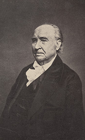
Martin Beaser.

Portrait of Martin Beaser on page 24.
On the fifth day of July 1854, Asaph Whittlesey and George Kilborn left La Pointe, in a row-boat, with the design of finding a “town site” on some available point near the “head of the bay.” At five o’clock P.M. of the same day they landed at the westerly limit of the present town site of Ashland. As Mr. Whittlesey stepped ashore, Mr. Kilborn exclaimed, “Here is the place for a big city!” and handing his companion an axe, he added, “I want you to have the honor of cutting the first tree in a way of a settlement upon the town site.” And the tree thus felled formed one of the foundation logs in the first building in the place. Such is the statement which has found its way into print as to the beginning of Ashland. But the same account adds: “Many new-comers arrived during the first few years after the settlement; among them Martin Beaser, who located permanently in Ashland in 1856, and was one of its founders.”1 How this was will soon be explained.
The father of the subject of this sketch, John Baptiste Beaser, was a native of Switzerland, educated as a priest, but never took orders. He came to America, reaching Philadelphia about the year 1812, where he married Margaret McLeod. They then moved to Buffalo, in one of the suburbs of which, called Williamsville, their son Martin was born, on the twenty-seventh of October, 1822. The boy received his early education in the common schools of the place, when, at the age of fourteen, he went on a whaling voyage, sailing from New Bedford, Massachusetts. His voyage lasted four years; his second voyage, three years; the last of which was made in the whaleship Rosseau, which is still afloat, the oldest of its class in America.
The young man went out as boat-steerer on his second voyage, returning as third mate. During his leisure time on shipboard and the interval between the two voyages, he spent in studying the science of navigation, which he successfully mastered. On his return from his fourth years’ cruise in the Pacific and Indian oceans, he was offered the position of second mate on a new ship then nearing completion and which would be ready to sail in about sixty days. He accepted the offer. They would notify him when the ship was ready, and he would in the meantime visit his mother, then a widow, residing in Buffalo. Accordingly, after an absence of seven years, he returned to his native city, spending the time in renewing old acquaintances and relating the varied experience of a whaler’s life. He had rare conversational powers, holding his listeners spell-bound at the recital of some thrilling adventure. A journal kept by him during his voyages and now in the possession of his family, abounds in hair-breadth escapes from savages on the shores of some of the South sea islands and the perils of whale-fishing, of which he had many narrow escapes. The time passed quickly, and he anxiously awaited the summons to join his ship. Leaving the city for a day the expected letter came, but was carefully concealed by his mother until after the ship had sailed, thus entirely changing the future of his life.
“… Martin, a sailor just from the whaling grounds of the Northwest Coast …”
Disappointed in his aspirations to command a ship in the near future, as he had reasons to hope from the rapid promotions he had already received – from a boy before the mast to mate of a ship in two voyages – and yielding to his mother’s wish not to leave home again, he engaged in sailing on Lake Erie from Buffalo to Detroit until 1847, when he went in the interest of a company in the latter city to Lake Superior for the purpose of exploring the copper ranges in the northern peninsula of Michigan. He coasted from Sault Ste. Marie to Ontonagon in a bateau. Remaining in the employ of the company about a year, he then engaged in a general forwarding and commission business for himself.
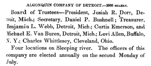
“Algonquin Company of Detroit.”
~ Reports of Wm. A. Burt and Bela Hubbard, by T. W. Bristol, 1846, page 97.
~ A History of the Northern Peninsula of Michigan and Its People: Volume 1, by Alvah Littlefield Sawyer, 1911, page 222.
Mr. Beaser was largely identified with the early mining interests of Ontonagon county, being instrumental in opening up and developing some of the best mines in that district.
In 1848 he was married in Cattaraugus county, New York, in the town of Perrysburgh, to Laura Antionette Bebee. The husband and wife the next spring went west, going to Ontonagon by way of Detroit. The trip from buffalo lasted from the first day of May to the sixth of June, they being detained at the “Soo” two weeks on account of the changing of the schooner Napoleon into a propeller, in which vessel, after a voyage of six days, they reached Ontonagon.
Here Mr. Beaser resided for seven years in the same business of forwarding and commission, furnishing frequently powder and candles to the miners by the ton. He was a portion of the this time associated with Thomas B. Hanna, formerly of Ohio. They then sold out their interest – Mr. Beaser going in company with Augustus Coburn and Edward Sayles to Superior, at the head of the lake, taking a small boat with them and Indian guides. Thus equipped they explored the region of Duluth, going up the Brule and St. Louis rivers. They then returned to La Pointe, going up Chaquamegon bay; and having their attention called to the site of what is now Ashland, on account of what seemed to be its favorable geographical position. As there had been some talk of the feasibility of connecting the Mississippi river and Lake Superior by a ship canal, it was suggested to them that this point would be a good one for its eastern terminus. Another circumstance which struck them was the contiguity of the Penokee iron range. This was in 1853. The company then returned to Ontonagon.
Closing up his business at the latter place, Mr. Beaser decided to return to the bay of Chaquamegon to look up and locate the town site on its southern shore. In the summer of 1854, on arriving there, he found Mr. Whittlesey and Mr. Kilborn on the ground. He then made arrangement with them by which he (Mr. Beaser) was to enter the land, which he did at Superior, where the land office was then located for that section. The contract between the three was, that Mr. Whittlesey and Mr. Kilborn were to receive each an eighth interest in the land, while the residue was to go to Mr. Beaser. The patent for the land was issued to Schuyler Goff, as county Judge of La Pointe county, Wisconsin, who was the trustee for the three men, under the law then governing the location of town sites.
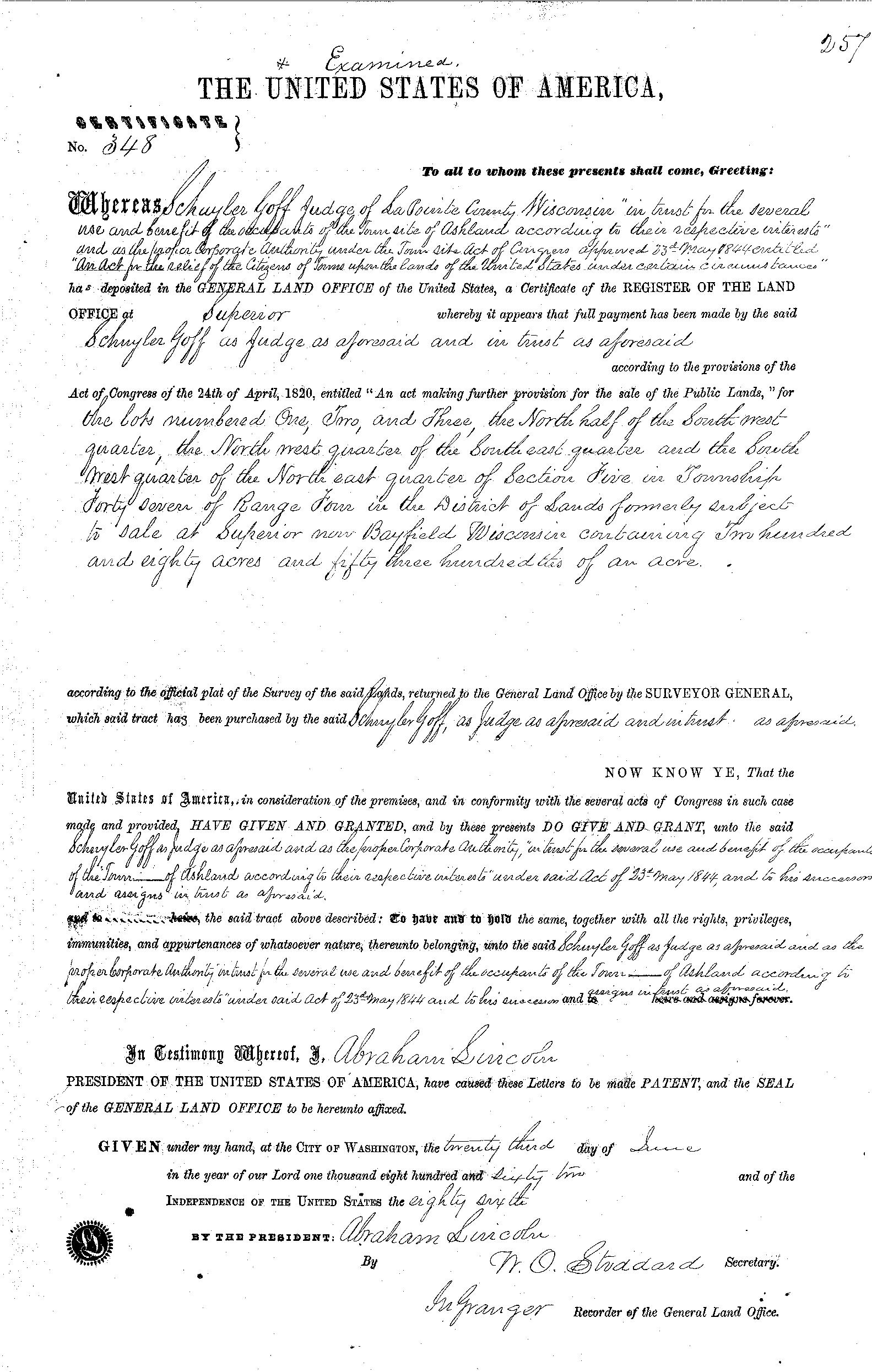
La Pointe County Judge Schuyler Goff was issued this patent for 280.53 acres on June 23rd, 1862, on behalf of Martin Beaser, Asaph Whittlesey, and George Kilburn.
~ General Land Office Records
Mr. Beaser afterwards got his deed from the judge to his three-quarters’ interest in the site.

Beaser named Ashland in honor of the Henry Clay Estate in Kentucky.
~ National Park Service
In January, 1854, Mr. Beaser having previously engaged a topographical engineer, G.L. Brunschweiler, the two, with a dog train and two Indians, made the journey from Ontonagon to the proposed town site, where Mr. Brunschweiler surveyed and platted2 a town on the land of the men before spoken of as parties in interest, to which town Mr. Beaser gave the name of Ashland. These three men, therefore, were the founders of Ashland, although afterwards various additions were made to it.
Mr. Beaser did not bring his family to Ashland until the eighth of September, 1856. He engaged in the mercantile business there until the war broke out, and was drowned in the bay while attempting to come from Bayfield to Ashland in an open boat, during a storm, on the fourth of November, 1866. He was buried on Madeline island at La Pointe. He was “closely identified with enterprises tending to open up the country; was wealthy and expended freely; was a man of fine discretion and good, common sense.” He was never discouraged as to Ashland’s future prosperity.
The children of Mr. Beaser, three in number, are all living: Margaret Elizabeth, wife of James A. Croser of Menominee, Michigan; Percy McLeod, now of Ashland; and Harry Hamlin, also of Ashland, residing with his mother, now Mrs. Wilson, an intelligent and very estimable lady.
1 See ‘History of Northern Wisconsin,’ p. 67.
2 The date of the platting of Ashland by Brunschweiler is taken from the original plat in the possession of the recorder of Ashland county, Wisconsin.
Colonel Charles Whittlesey
May 27, 2016
By Amorin Mello

C.C. Baldwin was a friend, colleague, and biographer of Charles Whittlesey.
~ Memorial of Charles Candee Baldwin, LL. D.: Late President of the Western Reserve Historical Society, 1896, page iii.
This is a reproduction of Colonel Charles Whittlesey’s biography from the Magazine of Western History, Volume V, pages 534-548, as published by his successor Charles Candee Baldwin from the Western Reserve Historical Society. This biography provides extensive and intimate details about the life and profession of Whittlesey not available in other accounts about this legendary man.
Whittlesey came to Lake Superior in 1845 while working for the Algonquin Mining Company along the Keweenaw Peninsula’s copper region. His first trip to Chequamegon Bay appears to have been in 1849 while doing do a geological survey of the Penokee Mountains for David Dale Owen. Whittlesey played a dramatic role in American settlement of the Chequamegon Bay region. Whittlesey convinced his brother, Asaph Whittlesey Jr., to move from the Western Reserve in 1854 establish what became the City of Ashland at the head of Chequamegon Bay as a future port town for extracting and shipping minerals from the Penokee Mountains. Whittlesey’s influence can still be witnessed to this day through local landmarks named in his honor:
Whittlesey published more than two hundred books, pamphlets, and articles. For additional research resources, the extensive Charles Whittlesey Papers are available through the Western Reserve Historical Society in two series:
Magazine of Western History, Volume V, pages 534-548.
COLONEL CHARLES WHITTLESEY.

Map of the Connecticut Western Reserve in Ohio by William Sumner, September 1826.
~ Cleveland Public Library
![Asaph Whittlesey [Sr], Late of Tallmadge, Summit Co., Ohio by Vesta Hart Whittlesey and Susan Everett Whittlesey, né Fitch, 1872.](https://chequamegonhistory.com/wp-content/uploads/2016/05/asaph-whittlesey-vesta-hart.jpg)
[Father] Asaph Whittlesey [Sr], Late of Tallmadge, Summit Co., Ohio by [mother] Vesta Hart Whittlesey [posthumously] and [stepmother] Susan Everett Whittlesey, né Fitch, 1872.
~ Archive.org
War was then in the west, and his neighbors feared they might be the victims of the scalping knife. But the danger was different. In passing the Narrows, between Pittsburgh and Beaver, the wagon ran off a bank and turned completely over on the wife and children. They were rescued and revived, but the accident permanently impaired the health of Mr. Whittlesey.
Mr. Whittlesey was in Tallmadge, justice of the peace from soon after his arrival till near the close of his life, and postmaster from 1814, when the office was first established, to his death. He was again severely injured, but a strong constitution and unflinching will enabled him to accomplish much. He had a store, buying goods in Pittsburgh and bringing them in wagons to Tallmadge; and an ashery; and in 1818 he commenced the manufacture of iron on the Little Cuyahoga, below Middlebury.
The times were hard, tariff reduced, and in 1828 he returned to his farm prematurely old. He died in 1842. Says General Bierce,
“His intellect was naturally of a high order, his religious convictions were strong and never yielded to policy or expediency. He was plain in speech, sometimes abrupt. Those who respected him were more numerous than those who loved him. But for his friends, no one had a stronger attachment. His dislikes were not very well concealed or easily removed. In short, he was a man of strong mind, strong feelings, strong prejudices, strong affections and strong attachments, yet the whole was tempered with a strong sense of justice and strong religious feelings.”
[Uncle] Elisha Whittlesey
~ Collection of the U.S. House of Representatives

Portrait of Reverend David Bacon from ConnecticutHistory.org:
“David Bacon (1771 – August 27, 1817) was an American missionary in Michigan Territory. He was born in Woodstock, Connecticut. He worked primarily with the Ottawa and Chippewa tribes, although they were not particularly receptive to his Christian teachings. He founded the town of Tallmadge, Ohio, which later became the center of the Congregationalist faith in Ohio.”
~ Wikipedia.org
Tallmadge was settled in 1808 as a religious colony of New England Congregationalists, by a colony led by Rev. David Bacon, a missionary to the Indians. This affected the society in which the boy lived, and exercised much influence on the morality of the town and the future of its children, one of whom was the Rev. Leonard Bacon. Rev. Timlow’s History of Southington says, “Mr. Whittlesey moved to Tallmadge, having become interested in settling a portion of Portage county with Christian families.” And that he was a man “of surpassing excellence of character.”
If it should seem that I have dwelt upon the parents of Colonel Whittlesey, it is because his own character and career were strongly affected by their characters and history. Charles, the son, combined the traits of the two. He commenced school at four years old in Southington; the next year he attended the log school house at Tallmadge until 1819, when the frame academy was finished and he attended it in winter, working on the farm in summer until he was nineteen.
The boy, too, saw early life on foot, horseback and with ox-teams. He found the Indians still on the Reserve, and in person witnessed the change from savage life and new settlements, to a state of three millions of people, and a large city around him. One of Colonel Whittlesey’s happiest speeches is a sketch of log cabin times in Tallmadge, delivered at the semi-centennial there in 1857.
~ Annual Report on the Geological Survey of the State of Ohio: 1837 by Ohio Geologist William Williams Mather, 1838, page 22.
In 1827 the youngster became a cadet at West Point. Here he displayed industry, and in some unusual incidents there, coolness and courage. He graduated in 1831, and became brevet second lieutenant in the Fifth United States infantry, and in November started to join his regiment at Mackinaw. He did duty through the winter with the garrison at Fort Gratiot. In the spring he was assigned at Green Bay to the company of Captain Martin Scott, so famous as a shot. At the close of the Black Hawk War he resigned from the army. Though recognizing the claim of the country to the services of the graduates of West Point, he tendered his services to the government during the Seminole Mexican war. By a varied experience his life thereafter was given to wide and general uses. He at first opened a law office in Cleveland, Ohio, and was fully occupied in his profession, and as part owner and co-editor of the Whig and Herald until the year 1837. He was that year appointed assistant geologist of the state of Ohio. Through very uneconomical economy, the survey was discontinued at the end of two years, when the work was partly done and no final reports had been made. Of course most of the work and its results were lost. Great and permanent good indeed resulted to the material wealth of the state, in disclosing the rich coal and iron deposit of southeastern Ohio, thus laying the foundation for the vast manufacturing industries which have made that portion of the state populous and prosperous. The other gentlemen associated with him were Professor William Mather as principal; Dr. Kirtland was entrusted with natural history. Others were Dr. S. P. Hildreth, Dr. Caleb Briggs, Jr., Professor John Locke and Dr. J. W. Foster. It was an able corps, and the final results would have been very valuable and accurate. In 1884, Colonel Whittlesey was sole survivor and said in this Magazine:
“Fifty years since, geology had barely obtained a standing among the sciences even in Europe. In Ohio it was scarcely recognized. The state at that time was more of a wilderness than a cultivated country, and the survey was in progress little more than two years. It was unexpectedly brought to a close without a final report. No provision was made for the preservation of papers, field notes and maps.”
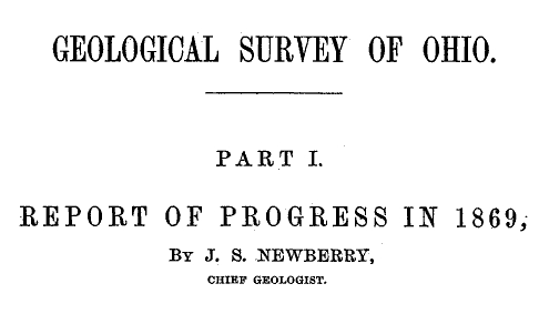
Report of Progress in 1869, by J. S. Newberry, Chief Geologist, by the Geological Survey of Ohio, 1870.
Professor Newbury, in a brief resume of the work of the first survey (report of 1869), says the benefits derived “conclusively demonstrate that the geological survey was a producer and not a consumer, that it added far more than it took from the public treasury and deserved special encouragement and support as a wealth producing agency in our darkest financial hour.” The publication of the first board, “did much,” says Professor Newberry, “to arrest useless expenditure of money in the search for coal outside of the coal fields and in other mining enterprises equally fallacious, by which, through ignorance of the teachings of geology, parties were constantly led to squander their means.” “It is scarcely less important to let our people know what we have not, than what we have, among our mineral resources.”

“Descriptions of Ancient Works in Ohio. By Charles Whittlesey, of the late Geological Corps of Ohio.”
~ Smithsonian Contributions to Knowledge, Volume III., Article 7, 1852.
The topographical and mathematical parts of the survey were committed to Colonel Whittlesey. He made partial reports, to be found in the ‘State Documents’ of 1838 and 1839, but his knowledge acquired in the survey was of vastly greater service in many subsequent writings, and, as a foundation for learning, made useful in many business enterprises of Ohio. He had, during this survey, examined and surveyed many ancient works in the state, and, at its close, Mr. Joseph Sullivant, a wealthy gentleman interested in archaeology, residing in Columbus, proposed that, he bearing the actual expense, Whittlesey should continue the survey of the works of the Mound Builders, with a view to joint publication. During the years 1839 and 1840, and under the arrangement, he made examination of nearly all the remaining works then discovered, but nothing was done toward their publication. Many of his plans and notes were used by Messrs. Squier & Davis, in 1845 and 1846, in their great work, which was the first volume of the Smithsonian Contributions, and in that work these gentlemen said:
“Among the most zealous investigators in the field of American antiquarian research is Charles Whittlesey, esq., of Cleveland, formerly topographical engineer of Ohio. His surveys and observations, carried on for many years and over a wide field, have been both numerous and accurate, and are among the most valuable in all respects of any hitherto made. Although Mr. Whittlesey, in conjunction with Joseph Sullivant, esq., of Columbus, originally contemplated a joint work, in which the results of his investigations should be embodied, he has, nevertheless, with a liberality which will be not less appreciated by the public than by the authors, contributed to this memoir about twenty plans of ancient works, which, with the accompanying explanations and general observations, will be found embodied in the following pages.
“It is to be hoped the public may be put in possession of the entire results of Mr. Whittlesey’s labor, which could not fail of adding greatly to our stock of knowledge on this interesting subject.”

“Marietta Works, Ohio. Charles Whittlesey, Surveyor 1837.”
~ Smithsonian Contributions to Knowledge, Volume I., Plate XXVI.
It will be seen that Mr. Whittlesey was now fairly started, interested and intelligent, in the several fields which he was to make his own. And his very numerous writings may be fairly divided into geology, archaeology, history, religion, with an occasional study of topographical geology. A part of Colonel Whittlesey’s surveys were published in 1850, as one of the Smithsonian contributions; portions of the plans and minutes were unfortunately lost. Fortunately the finest and largest works surveyed by him were published. Among those in the work of Squier & Davis, were the wonderful extensive works at Newark, and those at Marietta. No one again could see those works extending over areas of twelve and fifteen miles, as he did. Farmers cannot raise crops without plows, and the geography of the works at Newark must still be learned from the work of Colonel Whittlesey.
~ Smithsonian Contributions to Knowledge, Volume XIII., Article IV., page 2 of “Ancient Mining on the Shores of Lake Superior” by Charles Whittlesey.
He made an agricultural survey of Hamilton county in 1844. That year the copper mines of Michigan began to excite enthusiasm. The next year a company was organized in Detroit, of which Colonel Whittlesey was the geologist. In August they launched their boat above the rapids of the Sault St. Marie and coasted along the shore to where is now Marquette. Iron ore was beneath notice, and in truth was no then transportable, and they pulled away for Copper Harbor, and then to the region between Portage lake and Ontonagon, where the Algonquin and Douglas Houghton mines were opened. The party narrowly escaped drowning the night they landed. Dr. Houghton was drowned the same night not far from them. A very interesting and life-like account of their adventures was published by Colonel Whittlesey in the National Magazine of New York City, entitled “Two Months in the Copper Regions.” From 1847 to 1851 inclusive, he was employed by the United States in the survey of the country around Lake Superior and the upper Mississippi, in reference to mines and minerals. After that he spent much time in exploring and surveying the mineral district of the Lake Superior basin. The wild life of the woods with a guide and voyageurs threading the streams had great attractions for him and he spent in all fifteen seasons upon Lake Superior and the upper Mississippi, becoming thoroughly familiar with the topography and geological character of that part of the country.

“Pictograph C. Okundekund [Okandikan] and his Band of Ontonagon – Michigan,” as reproduced from birch bark by Seth Eastman, and published as Plate 62 in Historical and Statistical Information Respecting the History, Condition, and Prospects of the Indian Tribes of the United States, Volume I., by Henry Rowe Schoolcraft, 1851. This was one of several pictograph petitions from the 1849 Martell delegation:
“By this scroll, the chief Kun-de-kund of the Eagle totem of the river Ontonagon, of Lake Superior, and certain individuals of his band, are represented as uniting in the object of their visit of Oshcabewis. He is depicted by the figure of an eagle, Number 1. The two small lines ascending from the head of the bird denote authority or power generally. The human arm extended from the breast of the bird, with the open hand, are symbolic of friendship. By the light lines connecting the eye of each person with the chief, and that of the chief with the President, (Number 8,) unity of views or purpose, the same as in pictography Number 1, is symbolized. Number 2, 3, 4, and 5, are warriors of his own totem and kindred. Their names, in their order, are On-gwai-sug, Was-sa-ge-zhig, or The Sky that lightens, Kwe-we-ziash-ish, or the Bad-boy, and Gitch-ee-man-tau-gum-ee, or the great sounding water. Number 6. Na-boab-ains, or Little Soup, is a warrior of his band of the Catfish totem. Figure Number 7, repeated, represents dwelling-houses, and this device is employed to deonte that the persons, beneath whose symbolic totem it is respectively drawn, are inclined to live in houses and become civilized, in other words, to abandon the chase. Number 8 depicts the President of the United States standing in his official residence at Washington. The open hand extended is employed as a symbol of friendship, corresponding exactly, in this respect, with the same feature in Number 1. The chief whose name is withheld at the left hand of the inferior figures of the scroll, is represented by the rays on his head, (Figure 9,) as, apparently, possessing a higher power than Number 1, but is still concurring, by the eye-line, with Kundekund in the purport of pictograph Number 1.”
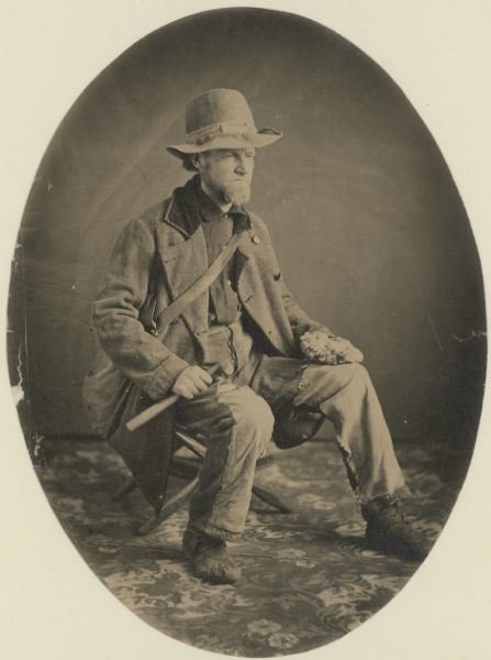
“Studio portrait of geologist Charles Whittlesey dressed for a field trip.” Circa 1858.
~ Wisconsin Historical Society
His detailed examination extended along the copper range from the extreme east of Point Keweenaw to Ontonagon, through the Porcupine mountain to the Montreal river, and thence to Long lake in Wisconsin, a distance of two hundred miles. In 1849, 1850 and 1858 he explored the valley of the Menominee river from its mouth to the Brule. He was the first geologist to explore the South range. The Wisconsin Geological Survey (Vol. 3 pp. 490 and 679) says this range was first observed by him, and that he many years ago drew attention to its promise of merchantable ores which are now extensively developed from the Wauceda to the Commonwealth mines, and for several miles beyond. He examined the north shore from Fond du Lac east, one hundred miles, the copper range of Minnesota and on the St. Louis river to the bounds of our country. His report was published by the state in 1865, and was stated by Professor Winchill to be the most valuable made.
All his geological work was thorough, and the development of the mineral resources which he examined, and upon which he reported, gave the best proofs of his scientific ability and judgment.

“Outline Map Showing the Position of the Ancient Mine Pits of Point Keweenaw, Michigan by Charles Whittlesey.”
~ Smithsonian Contributions to Knowledge, Volume XIII., Article IV., frontpiece of “Ancient Mining on the Shores of Lake Superior” by Charles Whittlesey, 1863.
With the important results from his labors in Ohio in mind, the state of Wisconsin secured his services upon the geological survey of that state, carried on in 1858, 1859 and 1860, and terminated only by the war. The Wisconsin survey was resumed by other parties, and the third volume of the Report for Northern Wisconsin, page 58, says:
The Contract of James Hall with Charles Whittlesey is available from the Journal of the Assembly of Wisconsin, Volume I, pages 178-179, 1862. Whittlesey was to perform “a careful geological survey of the country lying between the Montreal river on the east, and the westerly branches of [the] Bad River on west”. This contract was unfulfilled due to the outbreak of the American Civil War. Whittlesey independently published his survey of the Penokee Mountains in 1865 without Hall. Some of Whittlesey”s pamphlets have been republished here on Chequamegon History in the Western Reserve category of posts.“The only geological examinations of this region, however, previous to those on which the report is based, and deserving the name, were those of Colonel Charles Whittlesey of Cleveland, Ohio. This gentleman was connected with Dr. D. D. Owen’s United States geological survey of Wisconsin, Iowa and Minnesota, and in this connection examined the Bad River country, in 1848. The results are given in Dr. Owen’s final report, published in Washington, in 1852. In 1860 (August to October) Colonel Whittlesey engaged in another geological exploration in Ashland, Bayfield and Douglass counties, as part of the geological survey of Wisconsin, then organized under James Hall. His report, presented to Professor Hall in the ensuing year, was never published, on account of the stoppage of the survey. A suite of specimens, collected by Colonel Whittlesey during these explorations, is at present preserved in the cabinet of the state university at Madison, and it bears testimony to the laborious manner in which that gentleman prosecuted the work. Although the report was never published, he has issued a number of pamphlet publications, giving the main results obtained by him. A list of them, with full extracts from some of them, will be found in an appendix to the report. In the same appendix I have reproduced a geological map of this region, prepared by Colonel Whittlesey in 1860.”

“Geological Map of the Penokie Range.” by Charles Whittlesey, Dec. 1860.
~ Geology of Wisconsin. Survey of 1873-1879. Volume III., 1880, Plate XX, page 214.
~ Biographical Register of the Officers and Graduates of the United States Military Academy at West Point, New York, since its establishment in 1802 by George W. Cullum, page 496.
“The Baltimore Plot was an alleged conspiracy in late February 1861 to assassinate President-elect Abraham Lincoln en route to his inauguration. Allan Pinkerton, founder of the Pinkerton National Detective Agency, played a key role by managing Lincoln’s security throughout the journey. Though scholars debate whether or not the threat was real, clearly Lincoln and his advisors believed that there was a threat and took actions to ensure his safe passage through Baltimore, Maryland.”
~ Wikipedia.org
Such was Colonel Whittlesey’s employment when the first signs of the civil war appeared. He abandoned it at once. He became a member of one of the military companies that tendered its services to President-elect Lincoln, when he was first threatened, in February, 1861. He became quickly convinced that war was inevitable, and urged the state authorities that Ohio be put at once in preparation for it; and it was partly through his influence that Ohio was so very ready for the fray, in which, at first, the general government relied on the states. Two days after the proclamation of April 15, 1861, he joined the governor’s staff as assistant quartermaster-general. He served in the field in West Virginia with the three months’ men, as state military engineer; with the Ohio troops, under General McClellan, Cox and Hill. At Seary Run, on the Kanawha, July 17, 1861, he distinguished himself by intrepidity and coolness during a severe engagement, in which his horse was shot under him. At the expiration of the three months’ service, he was appointed colonel of the Twentieth regiment, Ohio volunteers, and detailed by General Mitchell as chief engineer of the department of Ohio, where he planned and constructed the defenses of Cincinnati.

“[Brother] Asaph Whittlesey [Jr.] dressed for his journey from Ashland to Madison, Wisconsin, to take up his seat in the state legislature. Whittlesey is attired for the long trek in winter gear including goggles, a walking staff, and snowshoes.” Circa 1860.
~ Wisconsin Historical Society
“SIR: Will you allow me to suggest the consideration of a great movement by land and water, up the Cumberland and Tennessee rivers.
“First, Would it not allow of water transportation half way to Nashville?
“Second, Would it not necessitate the evacuation of Columbus, by threatening their railway communications?
“Third, Would it not necessitate the retreat of General Buckner, by threatening his railway lines?
“Fourth, Is it not the most feasible route into Tennessee?”
This plan was adopted, and Colonel Whittlesey’s regiment took part in its execution.
In April, 1862, on the second day of the battle of Shiloh, Colonel Whittlesey commanded the Third brigade of General Wallace’s division — the Twentieth, Fifty-sixth, Seventy-sixth and Seventy-eighth Ohio regiments. “It was against the line of that brigade that General Beauregard attempted to throw the whole weight of his force for a last desperate charge; but he was driven back by the terrible fire, that his men were unable to face.” As to his conduct, Senator Sherman said in the United States senate.1
The official report of General Wallace leaves little to be said. The division commander says, “The firing was grand and terrible. Before us was the Crescent regiment of New Orleans; shelling us on our right was the Washington artillery of Manassas renown, whose last charge was made in front of Colonel Whittlesey’s command.”
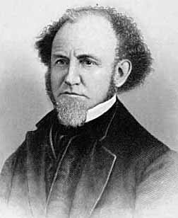
“This is an engraved portrait of Charles Whittlesey, a prominent soldier, attorney, scholar, newspaper editor, and geologist during the nineteenth century. He participated in a geological survey of Ohio conducted in the late 1830s, during which he discovered numerous Native American earthworks. In 1867, Whittlesey helped establish the Western Reserve Historical Society, and he served as the organization’s president until his death in 1886. Whittlesey also wrote approximately two hundred books and articles, mostly on geology and Ohio’s early history.”
~ Ohio History Central
General Force, then lieutenant-colonel under Colonel Whittlesey, fully describes the battle,2 and quotes General Wallace. “The nation is indebted to our brigade for the important services rendered, with the small loss it sustained and the manner in which Colonel Whittlesey handled it.”
Colonel Whittlesey was fortunate in escaping with his life, for General Force says, it was ascertained that the rebels had been deliberately firing at him, sometimes waiting to get a line shot.
Colonel Whittlesey had for some time been in bad health, and contemplating resignation, but deferring it for a decisive battle. Regarding this battle as virtually closing the campaign in the southwest, and believing the Rebellion to be near its end, he now sent it in.
General Grant endorsed his application, “We cannot afford to lose so good an officer.”
“Few officers,” it is said, “retired from the army with a cleaner or more satisfactory record, or with greater regret on the part of their associates.” The Twentieth was an early volunteer regiment. The men were citizens of intelligence and character. They reached high discipline without severity, and without that ill-feeling that often existed between men and their officers. There was no emergency in which they could not be relied upon. “Between them and their commander existed a strong mutual regard, which, on their part, was happily expressed by a letter signed by all the non-commissioned officers.”
“CAMP SHILOH, NEAR PITTSBURGH LANDING, TENNESSEE, April 21, 1862.
“COL. CHAS. WHITTLESEY:
“Sir — We deeply regret that you have resigned the command of the Twentieth Ohio. The considerate care evinced for the soldiers in camp, and, above all, the courage, coolness and prudence displayed on the battle-field, have inspired officers and men with the highest esteem for, and most unbounded confidence in our commander.
“From what we have seen at Fort Donelson, and at the bloody field near Pittsburgh, on Monday, the seventh, all felt ready to follow you unfalteringly into any contest and into any post of danger.
“While giving expression to our unfeigned sorrow at your departure from us, and assurance of our high regard and esteem for you, and unwavering confidence as our leader, we would follow you with the earnest hope that your future days may be spent in uninterrupted peace and quiet, enjoying the happy reflections and richly earned rewards of well-spent service in the cause of our blessed country in its dark hour of need.”
Said Mr. W. H. Searles, who served under him, at the memorial meeting of the Engineers Club of Cleveland: “In the war he was genial and charitable, but had that conscientious devotion to duty characteristic of a West Point soldier.”
Since Colonel Whittlesey’s decease the following letter was received:
“CINCINNATI, November 10, 1886.
“DEAR MRS. WHITTLESEY: — Your noble husband has got release from the pains and ills that made life a burden. His active life was a lesson to us how to live. His latter years showed us how to endure. To all of us in the Twentieth Ohio regiment he seemed a father. I do not know any other colonel that was so revered by his regiment. Since the war he has constantly surprised me with his incessant literary and scientific activity. Always his character was an example and an incitement. Very truly yours,
“M. F. Force.”
Colonel Whittlesey now turned his attention at once again to explorations in the Lake Superior and upper Mississippi basins, and “new additions to the mineral wealth of the country were the result of his surveys and researches.” His geological papers commencing again in 1863, show his industry and ability.
It happened during his life many times, and will happen again and again, that his labors as an original investigator have borne and will bear fruit long afterwards, and, as the world looks at fruition, of much greater value to others than to himself.
~ Report of a geological survey of Wisconsin, Iowa, and Minnesota: and incidentally of a portion of Nebraska Territory, by David Dale Owen, 1852, page 420.
He prognosticated as early as 1848, while on Dr. Owen’s survey, that the vast prairies of the northwest would in time be the great wheat region. These views were set forth in a letter requested by Captain Mullen of the Topographical Engineers, who had made a survey for the Northern Pacific railroad, and was read by him in a lecture before the New York Geographical society in the winter of 1863-4.
He examined the prairies between the head of the St. Louis river and Rainy Lake, between the Grand fork of Rainy Lake river and the Mississippi, and between the waters of Cass Lake and those of Red Lake. All were found so level that canals might be made across the summits more easily than several summits already cut in this country.
In 1879 the project attracted attention, and Mr. Seymour, the chief engineer and surveyor of New York, became zealous for it, and in his letters of 1880, to the Chambers of Commerce of Duluth and Buffalo, acknowledged the value of the information supplied by Colonel Whittlesey.
Says the Detroit Illustrated News:
“A large part of the distance from the navigable waters of Lake Superior to those of Red river, about three hundred and eight miles, is river channel easily utilized by levels and drains or navigable lakes. The lift is about one thousand feet to the Cass Lake summit. At Red river this canal will connect with the Manitoba system of navigation through Lake Winnipeg and the valleys of the Saskatchewan. Its probable cost is given at less than four millions of dollars, which is below the cost of a railway making the same connections. And it is estimated that a bushel of wheat may be carried from Red river to New York by water for seventeen cents, or about one-third of the cost of transportation by rail.”
We approach that part of the life of Colonel Whittlesey which was so valuable to our society. The society was proposed in 1866.3 Colonel Whittlesey’s own account of its foundation is: “The society originally comprised about twenty persons, organized in May, 1867, upon the suggestion of C. C. Baldwin, its present secretary. The real work fell upon Colonel Whittlesey, Mr. Goodman and Mr. Baldwin, Mr. Goodman devoting nearly all of his time until 1872 (the date of his death).” The statement is a very modest one on the part of Colonel Whittlesey. All looked to him to lead the movement, and none other could have approached his efficiency or ability as president of the society.
The society seemed as much to him as a child is to a parent, and his affection for it has been as great. By his learning, constant devotion without compensation from that time to his death, his value as inspiring confidence in the public, his wide acquaintance through the state, he has accomplished a wonderful result, and this society and its collections may well be regarded as his monument.
Mr. J. P. Holloway, in his memorial notice before the Civil Engineer’s club, of which Colonel Whittlesey was an honorary member, feelingly and justly said:
“Colonel Whittlesey will be best and longest remembered in Cleveland and on the Reserve, for his untiring interest and labors in seeking to rescue from oblivion the pioneer history of this portion of the state, and which culminated in the establishment of the present Western Reserve Historical society, of which for many years he was the presiding officer. It will be remembered by many here, how for years there was little else of the Western Reserve Historical society, except its active, hard working president. But as time moved on, and one by one the pioneers were passing away, there began to be felt an increasing interest in preserving not only the relics of a by-gone generation, but also the records of their trials and struggles, until now we can point with a feeling of pride to the collections of a society which owes its existence and success to a master spirit so recently called away.”
The colonel was remarkably successful in collecting the library, in which he interested with excellent pecuniary purpose the late Mr. Case. He commenced the collection of a permanent fund which is now over ten thousand dollars. It had reached that amount when its increase was at once stopped by the panic of 1873, and while it was growing most rapidly. The permanent rooms, the large and very valuable museum, are all due in greatest measure to the colonel’s intelligent influence and devotion.
I well remember the interest with which he received the plan; the instant devotion to it, the zeal with which at once and before the society was started, he began the preparation of his valuable book, The Early History of Cleveland, published during the year.
Colonel Whittlesey was author of — I had almost said most, and I may with no dissent say— the most valuable publications of the society. His own very wide reputation as an archaeologist and historian also redounded to its credit. But his most valuable work was not the most showy, and consisted in the constant and indefatigable zeal he had from 1867 to 1886, in its prosperity. These were twenty years when the welfare of the society was at all times his business and never off his mind. During the last few years Colonel Whittlesey has been confined to his home by rheumatism and other disorders, the seeds of which were contracted years before in his exposed life on Lake Superior, and he has not been at the rooms for years. He proposed some years since to resign, but the whole society would have felt that the fitness of things was over had the resignation been accepted. Many citizens of Cleveland recall that if Colonel Whittlesey could no longer travel about the city he could write. And it was fortunate that he could. He took great pleasure in reading and writing, and spent much of his time in his work, which continued when he was in a condition in which most men would have surrendered to suffering.
Colonel Whittlesey did not yet regard his labors as finished. During the last few years of his life religion, and the attitude and relation of science to it, engaged much of his thought, and he not unfrequently contributed an editorial or other article to some newspaper on the subject. Lately these had taken more systematic shape, and as late as the latter part of September, and within thirty days of his death, he closed a series of articles which were published in the Evangelical Messenger on “Theism and Atheism in Science.” These able articles were more systematic and complete than his previous writings on the subject, and we learn from the Messenger that they will be published in book form. The paper says:
Colonel Charles Whittlesey of this city, known to our readers as the author of an able series of articles on “Theism and Atheism in Science” just concluded, has fallen asleep in Jesus. One who knew the venerable man and loved him for his genuine worth said to us that “his last work on earth was the preparation of these articles . . . which to him was a labor of love and done for Christ’s sake.”
!["The Old Whittlesey Homestead, Euclid Avenue [Cleveland, Ohio]." ~ Historical Collections of Ohio in Two Volumes, by Henry Howe, 1907, page 521.](https://chequamegonhistory.com/wp-content/uploads/2016/05/whittlesey-home-cleveland.jpg)
“The Old Whittlesey Homestead, Euclid Avenue.” [Cleveland, Ohio]
~ Historical Collections of Ohio in Two Volumes by Henry Howe, 1907, page 521.
Colonel Whittlesey was married October 4, 1858, to Mrs. Mary E. (Lyon) Morgan4 of Oswego, New York, who survives him; they had no children.
!["Char. Whittlesey - Cleveland Ohio, Oct. 30, 1895[?] - Geologist of Ohio." ~ Wisconsin Historical Society](https://chequamegonhistory.com/wp-content/uploads/2016/05/charles-whittlesey-geologist.jpg)
Charles Whittlesey died on October 18th, 1886, and was never Ohio’s State Geologist.
“Char. Whittlesey – Cleveland Ohio, Oct. 30, 1895[?] – Geologist of Ohio.”
~ Wisconsin Historical Society
Much of his work does not therefore appear in that complete and systematic shape which would make it best known to the general public. But by scholars in his lines of study in Europe and America, he was well known and very highly respected. “His contributions to literature,” said the New York Herald,5 “have attracted wide attention among the scientific men of Europe and America.”
Whittlesey Culture:
A.D. 1000 to 1600
“‘Whittlesey Culture’ is an archaeological designation referring to a Late Prehistoric (more appropriately: Late Pre-Contact) North American indigenous group that occupied portions of northeastern Ohio. This culture isdistinguished from other so-called Late Prehistoric societies mainly by distinctive kinds of pottery. Many Whittlesey communities were located on plateaus overlooking stream valleys or the shores of Lake Erie. The villages often were surrounded with a pallisade or a ditch, suggesting a need for defense.
“The Whittlesey culture is named for Charles Whittlesey, a 19th century geologist and archaeologist who was a founder of the Western Reserve Historical Society.”
As an American archaeologist, Colonel Whittlesey was very learned and thorough. He had in Ohio the advantage of surveying its wonderful works at an early date. He had, too, that cool poise and self-possession that prevented his enthusiasm from coloring his judgment. He completely avoided errors into which a large share of archaeologists fall. The scanty information as to the past and its romantic interest, lead to easy but dangerous theories, and even suffers the practice of many impositions. He was of late years of great service in exposing frauds, and thereby helped the science to a healthy tone. It may be well enough to say that in one of his tracts he exposed, on what was apparently the best evidence, the supposed falsity of the Cincinnati tablet so called. Its authenticity was defended by Mr. Robert Clarke of Cincinnati, successfully and convincingly, to Colonel Whittlesey himself. I was with the colonel when he first heard of the successful defense and with a mutual friend who thought he might be chagrined, but he was so much more interested in the truth for its own sake, than in his relations to it, that he appeared much pleased with the result.
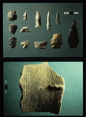
Whittlesey Culture artifacts: “South Park Village points (above) and pottery fragment (below)”
~ Cuyahoga Valley National Park
Among American writers, Mr. Short speaks of his investigations as of “greater value, due to the eminence of the antiquarian who writes them.” Hon. John D. Baldwin says, “in this Ancient America speaks of Colonel Whittlesey as one of the best authorities.” The learned Frenchman, Marquis de Nadaillac and writers generally upon such subjects quote his information and conclusions with that high and safe confidence in his learning and sound views which is the best tribute to Colonel Whittlesey, and at the same time a great help to the authors. And no one could write with any fullness on the archaeology of America without using liberally the work of Colonel Whittlesey, as will appear in any book on the subject. He was an extensive, original investigator, always observing, thoughtful and safe, and in some branches, as in Ancient Mining at Lake Superior, his work has been the substantial basis of present learning. It is noticeable that the most eminent gentlemen have best appreciated his safe and varied learning. Colonel Whittlesey was early in the geological field. Fifty years ago little was known of paleontology, and Colonel Whittlesey cared little for it, perhaps too little; but in economic geology, in his knowledge of Ohio, its surface, its strata, its iron, its coal and its limestone in his knowledge of the copper and iron of the northwest, he excelled indeed. From that date to his death he studied intelligently these sections. As Professor Lapham said he was studying Wisconsin, so did Colonel Whittlesey give himself to Ohio, its mines and its miners, its manufactures, dealings in coal and iron, its history, archaeology, its religion and its morals. Nearly all his articles contributed to magazines were to western magazines, and anyone who undertook a literary enterprise in the state of Ohio that promised value was sure to have his aid.6
In geology his services were great. The New York Herald, already cited, speaks of his help toward opening coal mines in Ohio and adds,“he was largely instrumental in discovering and causing the development of the great iron and copper regions of Lake Superior.” Twenty-six years ago he discovered a now famous range of iron ore.
“ On the Mound Builders and on the geological character and phenomena of the region of the lakes and the northwest he was quoted extensively as an authority in most of the standard geological and anthropological works of America and Europe,” truthfully says the ‘Biographical Cyclopedia.
Colonel Whittlesey was as zealous in helping to preserve new and original material for history as for science. In 1869 he pushed with energy the investigation, examination and measures which resulted in the purchase by the State of Ohio of the St. Clair papers so admirably, fully and ably edited by Mr. William Henry Smith, and in 1882 published in two large and handsome volumes by Messrs. Robert Clarke and Co. of Cincinnati.
Colonel Whittlesey was very prominent in the project which ended in the publication of the Margry papers in Paris. Their value may be gathered from the writing of Mr. Parkman (La Salle) and The Narrative and Critical History of America, Volume IV., where on page 242 is an account of their publication.7 In 1870 and 1871 an effort to enlist congress failed. The Boston fire defeated the efforts of Mr. Parkman to have them published in that city. Colonel Whittlesey originated the plan eventually adopted, by which congress voted ten thousand dollars as a subscription for five hundred copies, and, as says our history: “at last by Mr. Parkman’s assiduous labors in the east, and by those of Colonel Whittlesey, Mr. O. H. Marshall and others in the west,” the bill was passed.
The late President Garfield, an active member of our society, took a lively interest in the matter, and instigated by Colonel Whittlesey used his strong influence in its favor. Mr. Margry has felt and expressed a very warm feeling for Colonel Whittlesey for his interest and efforts, and since the colonel’s death, and in ignorance of it, has written him a characteristic letter to announce to the colonel, first of any in America, the completion of the work. A copy of the letter follows :
“PARIS, November 4, 1886.
“VERY DEAR AND HONORED SIR: It is to-day in France, St. Charles’ day, the holiday I wished when I had friends so called. I thought it suitable to send you to-day the good news to continue celebrating as of old. You will now be the first in America to whom I write it. I have just given the check to be drawn, for the last leaves of the work, of which your portrait may show a volume under your arm.8 Therefore there is no more but stitching to be done to send the book on its way.
“In telling you this I will not forget to tell you that I well remembered the part you took in that, publication as new, as glorious for the origin of your state, and for which you can congratulate yourself, in thanking you I have but one regret, that Mr. Marshall can not have the same pleasure. I hope that your health as well as that of Madame Whittlesey is satisfactory. I would be happy to hear so. For me if I am in good health it is only by the intervention of providence. However, I have lost much strength, though I do not show it. We must try to seem well.
“Receive, dear and honored sir, and for Madame, the assurance of my profound respect and attachment.
“PIERRE MARGRY.”
Colonel Whittlesey views of the lives of others were affected by his own. Devoted to extending human learning, with little thought of self interest, he was perhaps a little too impatient with others, whose lives had other ends deemed by them more practical. Yet after all, the colonel’s life was a real one, and his pursuits the best as being nearer to nature and far removed from the adventitious circumstances of what is ordinarily called polite life.
He impressed his associates as being full of learning, not from books, but nevertheless of all around — the roads the fields, the waters, the sky, men animals or plants. Charming it was to be with him in excursions; that was really life and elevated the mind and heart.
He was a profoundly religious man, never ostentatiously so, but to him religion and science were twin and inseparable companions. They were in his life and thought, and he wished to and did live to express in print his sense that the God of science was the God of religion, and that the Maker had not lost power over the thing made.
He rounded and finished his character as he finished his life, by joint and hearty affection and service to the two joint instruments of God’s revelation, for so he regarded them. Rev. Dr. Hayden testifies: “He had no patience with materialism, but in his mature strength of mind had harmonized the facts of science with the truths of religion.”

Charles Whittlesey
~ Magazine of Western History, Volume V, page 536.
Colonel Whittlesey’s life was plain, regular and simple. During the last few years he suffered much from catarrhal headache, rheumatism and kindred other troubles, and it was difficult for him to get around even with crutches. This was attributed to the exposure he had suffered for the fifteen years he had been exposed in the Lake Superior region, and his long life and preservation of a clear mind was no doubt due to his simple habits. With considerable bodily suffering, his mind was on the alert, and he seemed to have after all considerable happiness, and, to quote Dr Hayden, he could say with Byrd, “thy mind to me a kingdom is.”
Colonel Whittlesey was an original member of the American Association for the Advancement of Science, an old and valued member of the American Antiquarian society, an honorary member of the Ohio State Archaeological and Historical society, with headquarters at Columbus. He was trustee of the former State Archaeological society (making the archaeological exhibition at the Centennial), and although each of these is necessarily to some extent a rival of his pet society, he took a warm interest in the welfare of each.
He was a member of the Society of Americanites of France, and his judgment, learning and communications were much esteemed by the French members of that society. Of how many other societies he was an honorary or other member I can not tell.
C. C. Baldwin.
1 – Speech of May 9, 1862.
2 – Cincinnati Commercial, April 9, 1862.
3 – The society was organized under the auspices of the Cleveland Library Association (now Case Library). The plan occurred to the writer while vice-president of that association. At the annual meeting in 1867, the necessary changes were made in the constitution, and Colonel Whittlesey was elected to the Case Library board for the purpose of heading the historical committee and movement. The result appears in a scarce pamphlet issued in 1867 by the library association, containing, among other things, an account of the formation of the society and an address by Colonel Whittlesey, which is an interesting sketch of the successive literary and library societies of Cleveland, of which the first was in 1811.
4 – Mary E. Lyon was a daughter of James Lyon of Oswego, and sister of John E. Lyon, now of Oswego but years ago a prominent citizen of Cleveland. She m. first Colonel Theophilus Morgan,6 Theophilus,5 Theophilus,4 Theophilus,3 John,2 James Morgan.1 Colonel Morgan was an honored citizen of Oswego. Colonel Morgan and his wife Mary, had a son James Sherman, a very promising young man, killed in 1864 in a desperate cavalry charge in which he was lieutenant, in Sherman’s march to the sea. Mrs. Whittlesey survives in Cleveland.
5 – October, 19, 1886.
6 – The Hesperian, American Pioneer, the Western Literary Journal and Review of Cincinnati, the Democratic Review and Ohio Cultivator of Columbus, and later the Magazine of Western History at Cleveland, all received his hearty support.
7 – These papers were also described in an extract from a congressional speech of the late President Garfield. The extract is in Tract No. 20 of the Historical society.
8 – Alluding to a photograph of Colonel Whittlesey
then with a book under his arm.
By Amorin Mello
A curious series of correspondences from “Morgan”
… continued from Saint Croix Falls.

The Daily Union (Washington D.C.)
“Liberty, The Union, And The Constitution.”
July 31, 1845.
To the Editor of the Union:

Andrew Belcher Gray published the Map of the Mineral Lands Upon Lake Superior Ceded to the United States by the Treaty of 1842 With the Chippeway Indians in 1845.
~ Wisconsin Historical Society
SIR: In your paper of Tuesday evening, I have observed a communication from Copper Harbor, (Lake Superior,) so pregnant with errors or misrepresentations, that I am constrained, by a regard to truth and the public interests, to ask the use of your columns to correct some of them. I know not who your correspondent is; but, judging from the extraordinary zeal with which he labors to forestall public opinion of certain government agents on Lake Superior, whose conduct has recently become obnoxious to very grave suspicion, I think it no unwarrantable conclusion that he has either been most egregiously imposed upon, or that he is animated in his encomiums upon the officers alluded to, by motives much more special than in his admiring comments upon the handsome scenery and novel life upon the lake. He is evidently more than indifferently anxious to vindicate and extol General Stockton and his faithful deputy, Mr. Gray. Otherwise, what necessity would there be for asserting facts which do not exist? Your correspondent states that
“The only tenement on the island is a miserable log-cabin, in which General Stockton, for the want of better quarters, is compelled to keep his office. The room which he occupies, is only about eight feet square – just large enough to admit a narrow bed for himself, a table, and two or three chairs. In this salt-box of a room, he is compelled to transact all the business relating to the mineral lands embraced within this important agency. As many as a dozen men at a time are pressing forward to his ‘bee gum’ apartment, endeavoring to have their business transacted.
“The office of the surveyor of this mineral lands, in charge of Mr. Gray, at this agency, is still worse adapted to the transaction of public business. He is compelled to occupy the garret of the log-cabin,” &c.
Now, so far from this being true, “the miserable log cabin” of which your fastidious correspondent speaks, is an excellent hewed log house, well finished and ceiled, with three good-sized rooms below, and three above stairs, amply sufficient and convenient for all intended purposes. The construction of this house cost the government some fifteen hundred dollars, and was designed as the agency-house; whereas General Stockton has converted it into a sort of hotel – doubtless as a means of augmenting the perquisites of his station. Hence he has stinted himself, and the convenience of the government service, to his “bee-gum” and “salt-box” penetralia of “eight feet square.” So much for this misrepresentation.

Painting of Professor Douglass Houghton by Robert Thom. Houghton first explored the south shore of Lake Superior in 1840. Houghton died on Lake Superior during a storm on October 13, 1845. The City of Houghton on Chequamegon Bay was named in his honor, and is now known as the Houghton Falls State Natural Area.
Your correspondent expresses a like sympathy for the privations and long-suffering of Mr. Surveyor Gray. The apartment which Mr. Gray occupies above stairs, is an ample room, some fifteen or more feet square, and is quote comfortable – nay, quite luxurious quarters, when compared to those of the other surveyors, who are where Mr. Surveyor Gray should be, if he was faithfully discharging his duties – out in the woods and the weather, among the rocks and swamps, driving the compass and chain through almost impenetrable wilds. It may, perhaps, be a question with the government, as it certainly will be with the public, why Mr. Gray should be lolling at his ease in the agency-house on Porter’s island, while Dr. Houghton, the other surveyor, is traversing large tracts of the mineral lands, and sustaining all the hardships and perils which pertain to his employment? And it may become a further question, while I am on this head, why Mr. Gray, who was an unrelenting tool of the whig party, and neglected the public service, for which he was receiving a handsome salary, last year, to mingle in the orgies of federal-Clay-clubites, should not only be so sedulously retained in office, but be admitted to the privilege of almost total exemption from labor, which he is employed and paid to perform? It is a fact, that up to the 3d of July, Mr. Gray had surveyed only two miles, whereas Dr. Houghton had measured some five hundred miles of the mineral lands! And this is the gentleman against whose discomfort your correspondent so pathetically appeals, forsooth, because he is occupying at his ease an excellent apartment in a very comfortable house.
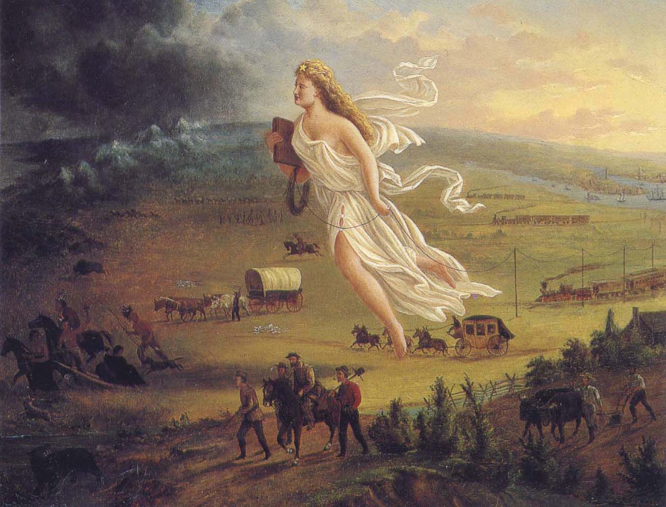
American Progress by John Gast, 1872
“This painting shows ‘Manifest Destiny’ (the belief that the United States should expand from the Atlantic to the Pacific Ocean. In 1872 artist John Gast painted a popular scene of people moving west that captured the view of Americans at the time. Called ‘Spirit of the Frontier’ and widely distributed as an engraving portrayed settlers moving west, guided and protected by Columbia (who represents America and is dressed in a Roman toga to represent classical republicanism) and aided by technology (railways, telegraph), driving Native Americans and bison into obscurity. It is also important to note that Columbia is bringing the ‘light’ as witnessed on the eastern side of the painting as she travels towards the ‘darkened’ west.”
~ Commons.Wikimedia.org
The design of this letter from Copper Harbor is perfectly apparent to me. It is the sequel to a movement which was made last June, viz: to white-wash and to shield from a just reprehension the present superintendent of the Lake Superior mineral lands. On the very day that General Stockton opened his office, a sort of soi-disant public meeting was gotten up there, in compliment to the General, in which the president of the New York and Lake Superior Mining Company was the prime mover. When it is known that General Stockton has certified to the Ordnance Department locations by this company of between one and three hundred square miles, upon which leases were granted, when not a single foot had been actually located, in flagrant violation of all the laws and regulations, some opinion may be formed of the secret of this most disinterested and valuable tribute to the official worth of this superintendent. What might have been the potency of this expression of public opinion (!) in protecting Gen. Stockton’s official conduct from censure and investigation up to the period of its dispensation, I will not now say. But, certain it is, that large and glaring spots which have begun to attract scrutiny and invoke exposure, have rendered his escutcheon needful of a new coat of white-washing; and hence this effort of your correspondent to forestall examination into his conduct, by pathetic epics of his patiently-endured privations iin the public service, and the ignorant or else sinister commendations of his conduct.
In animadverting upon the conduct of General Stockton and others, I do not mean to include Major Campbell, of whom everything that your correspondent has said is hereby confirmed.
POSTEA PLUS.
———

William Learned Marcy was the 20th United States Secretary of War during Polk’s presidency.
~ Wikipedia.org
We have omitted a large portion of the above communication, in which the writer proceeds to complain of the survey of the mineral lands, and arraigns the agents of the government for gross malversation in office. These charges are of a serious character, and they demand a full and rigid investigation. But, as it might lead to a protracted and angry war in the papers, in which crimination would be followed by recrimination; and as we are advised that the Secretary of War is determined to investigate the justice of these complaints and the truth of them – as he will receive any specifications in writing which may be submitted, and is determined to go to the bottom of the subject; and, with that view, will appoint a commission of two of the most respectable gentlemen he can obtain, who will go upon the lands, and probe everything for themselves, – we have thought it best to let matters take that turn. We have not the slightest doubt that the attention of the department is thoroughly exited to the importance of the duties which may devolve upon it, and that it will unquestionably discharge them. It is scarcely necessary, therefore, for the press to mingle at present in a discussion, which might occupy much space, lead to much excitement, and, after all, fail to lead to the best and wisest results.
– UNION.

The Daily Union (Washington D.C.)
“Liberty, The Union, And The Constitution.”
August 1, 1845.
THE COPPER REGION.

James Knox Polk:
11th President of the United States.
~ Wikipedia.org
We have been inconsiderately drawn into a subject of some importance to the United Sates. We have struck a vein, however, which promises to be rich in its resources. The reader will recollect a very long and interesting letter which we published on Tuesday evening, from one of our regular correspondents, who is now on a trip from New York to Lake Superior, in which he gave us a description of its peculiar and striking scenery, and made some remarks upon the copper lands in its vicinity, and upon the agents of the United States who have been charged with the care of the mineral lands belonging to the government. This letter drew forth a reply in our last evening’s paper; but we declined the publication of the whole communication, for the reasons which we then stated. The writer of that article charged the United States agent with many acts of mismanagement, and even malversation of office; and as we were aware that our government was about to appoint a commission to visit the country, and investigate the conduct of the agents, we deemed it most advisable to refer to another tribunal, (for the present, at least,) a full inquiry into these matters. In the mean time, a new scene was opened before us. We were scarcely aware of the existence of these mineral resources, – much less of their extent. But our curiosity is now being aroused. The public documents connected with them have been politely placed in our possession, and we shall prepare an article for the “Union” for the purpose of calling the attention of the country to this very interesting subject. The lead-mines belonging to the United States in Wisconsin, Illinois, Iowa, &c., have been longer known and are better understood than the copper region. They have been worked to a considerable extent, and their produce is so abundant, that they can not only supply our own market with lead, but afford a large export for the consumption of foreign nations. Perhaps no mines in the world are equal to those of the belt on both sides of the Mississippi.
Engraving depicting the 1820 Cass/Schoolcraft expedition crossing the Ontonagon River to investigate the famous copper boulder.
~ Wisconsin Historical Society
The purchase of this rock from the Chippewa Indians was made in 1841. The treaty with these Indians, ceding this portion of the country to the United States, was not made until October, 1842, after the second expedition to that country for the purpose of removing this rock. The Indians say that they did [not] reserve this rock in the treaty of 1842, as they had already sold it to a citizen of the United States, and they conceived that they had no further control over it. They say that, by their treaty, they only sold their lands, and suppose that all moveable property of this kind, which had been previously the subject of individual negotiation, would be allowed to be removed by the individuals making the purchase of them, as readily as they would be allowed to remove their lodges or canoes.
J. ELDRED, for self and sons.“
~ Public Documents Printed by Order of the Senate of the United States: First Session of the Twenty-Eigth Congress, 1844.

The Ontonagon Copper Boulder at the Smithsonian Institution National Museum of Natural History. Photograph by Ian Shackleford, 2011; shared with a Creative Commons license.
~ Wikipedia.org
The copper region is probably more important than the lead-mines. It is supposed by some geologists to extend from Lake Superior to Texas, crossing the Mississippi diagonally at a lower point than the lead-mines, and forming a vein of from thirty to forty miles of average width. The ore is said to be unusually rich. In some places it is mixed with veins of silver, so abundant that the precious metal alone is sufficient to pay all the expenses of working the vein – the ore itself making a yield of 60 or 70 per cent. of copper. An immense boulder of this metal is now deposited in the public yard between the War and Navy Departments, and is well worthy the inspection of all curious observers who happen to visit Washington. It weighs more than 3,700 lbs., and is so rich in the metal that a plate of copper is smoothed off on its surface like the copper-plate of the engraver. It was transported to Washington from the banks of the Ontonagon river, about forty miles from the Eagle river. The two principal points where the richest ore has yet been developed, are on Eagle river, and near Copper Harbor, on Lake Superior. But the richest portion of the copper region, as far as it is explored, is reputed to be Isle Royale, in Lake Superior, much nearer the Canada side than our own; but the boundary line runs north of the island, so that it falls within the limits of the United States. Isle Royale is estimated to be about thirty miles in length, and five miles broad – singularly rich in copper, which is constantly cropping out on the surface. The department has decided that no patents should be granted, and no leases taken, on this singular island.
Two large companies have been formed for leasing and working the mines in the Lake Superior Copper Region – the one which operates in New York, and the other in Boston. So valuable have shares become in some cases, that a gentleman in Boston, who is said to own about eighty shares, has been offered more than $600 for a single share. The supervision of these mines is devolved on the Ordnance Bureau, (Col. Talcott,) attached, of course to the War Department. Some important regulations have been made about the leasing of the mines, but further legislation will be required from Congress. The Secretary of War grants the permits to applicants to go upon the lands; and upon presenting a certificate from the agent of the United States that the tract has not been previously occupied, a lease may be granted for three years, upon condition of paying 6 per cent. of the nett proceeds of the metal, after it is smelted from the ore. If the lease be renewed for another three years, the rent is extended to 10 per cent. The leaseholders were originally confined to the smelting of the ore in the neighborhood of the mines; but it was found that, owing to the want of fuel, and other appliances, it was best to transport the ore to New York or Boston. The secretary yielded at last to the application – the government still receiving its 6 per cent. of rent, in the metal itself, free of all expense of transportation.
On the 21st of March last, it was determined by the Secretary of War to grant no more permits which would authorize a selection of more than one square mile; and between that time and 18th ult., seven hundred and sixty such permits were issued. It was then determined to stop the further issue. The cause of this is expressed in the printed circular from the Secretary of War, which we have already published. It states that,
“should locations be made pursuant to the permits already issued from this department, to select lands in the Lake Superior mineral district, the quantity required to satisfy them would exceed one million one hundred thousand acres It is apprehended that the whole region open for lation may not contain this quantity of mineral lands. Explorations and surveys of these lands have been ordered, and it has been determined to suspend the further issue of permits until the results shall be made known. The applications for permits received at the department subsequent to the 17th instant, will be filed in the office; and if the disclosures of the examinations shall warrant the further issue of permits for the Lake Superior region, they will be considered in the order in which they have been or shall be received. It is not expected that the results of the examinations and surveys to ascertain the probable quantity of mineral lands in the region, and to make the locations pursuant to the permits already issued, can be completed for some time to come.”
This is to certify, that on the 1st day of September last, while attending the payment of the Chippewa Indians at Lapointe, Lake Superior, Okondókon, being the head chief of the band of that tribe, and who resided at the mouth of the Ontonagon River, state, in my presence, that he had sold to Julius Eldred, of Detroit, in the summer of 1841, the celebrated copper rock; and that he had received, at the time of the sale, a portion of the sum agreed upo, and that there remained due him one hundred and five dollars, which was to be paid him whenever Mr. Eldred removed the rock to the shore of the lake; which sum of one hundred and five dollars Mr. Eldred did pay to Okondókon a few days thereafter, at the Ontonagon agency, in pursuace of the agreement made between them in 1841.
I further certify, that, on the 10th day of September last, Julius Eldred paid to Messrs. Hammond & Co. seventeen hundred and sixty-five dollars, for the services which they rendered in removing the rock, as well as to obtain peaceable possession of the same.
The removal of this copper rock has been attended with very great risk as well as expense, and is one of the most extraordinary performances of the age, and one which, in my opinion, should entitle him to great praise as well as liberal compensation.
WALTER CUNNINGHAM.“
~ Public Documents Printed by Order of the Senate of the United States: First Session of the Twenty-Eigth Congress, 1844.
It seems that Walter Cunningham, the first superintendent of these lands, kept no record of the permits he granted, or of the selection of tracts to which he certified as not interfering with the claims of others; and, in consequence of the absence of this information, it appears that his successor (Stockton) has, in two or three instances, certified for others, tracts previously certified by Mr. Cunningham; and this has given rise, as may be supposed, to some complaint. The certificates of the latter have been dropping in for a week or two past, but we know that very few or more can be in existence.
Mr. Gray (the only one of the assistants assigned to the superintendent, who possessed any competent knowledge of the surveying or platting) has been busily engaged in preparing maps, and locating the leases, and claims to leases thereon, to save from the risk of granting certificates which will interfere; and another competent surveyor has recently been sent to that country, in order that the operations may be expedited as fast as possible. It is also understood that Dr. Houghton is carrying on surveys under the orders of the General Land Office, which will soon extend into Stockton’s district, and will probably throw much additional light upon the extent of this interesting region of country.
We are informed that, as regards Mr. Gray’s mingling in any way with politicians, (as was stated by our correspondent of last evening,) it can scarcely be true. “He is a young man, who has been constantly moving about, and acquired no right to give a vote in any location. Modest and retiring, he is the last man in the world to do anything of the kind charged upon him.”
It will be seen, from this very rapid sketch, on imperfect data, that the copper region of the United States abounds with interest; that, from the abundance and the richness of the ore, it is probably calculated to furnish copper enough for our own consumption, and for a large exportation to foreign countries. Of course, great interests are growing up in that wonderful region – much speculation, large companies, strong contests for the possession of the titles – the same mine sometimes shingled over with several claims – some violence and some fraud. And even the agents of the government have not escaped the suspicion of mismanagement and malversation. The executive is about to do its duty in these respects. It is contemplated to employ two highly respectable commissioners to inspect the lands, to receive and investigate all complaints, and make a report to the War Department. A more complete report also, of the mineral resources of the West, the quality and extent of the mines, and the best way of working them, will probably be obtained, under the auspices of the vigilant Secretary of War, to be submitted to the next Congress. The statistics will, no doubt, be found valuable; and, in fact, the whole subject is every day assuming a new and a more expanding interest.
Two additional articles were published by The Daily Union on August 2 and August 11 regarding the Copper Region. They include extensive quotes from United States government agents involved in surveying the Copper Region, but are not directly related to the correspondences of “Morgan” or his accuser “Postea Plus” and therefore are not reproduced here on Chequamegon History.
The Daily Union (Washington D.C.)
“Liberty, The Union, And The Constitution.”
August 26, 1845.
[From our regular correspondent.]
GALENA, ILL., August 14, 1845.
Not having time to say more at present about the country through which I passed in coming from the falls of St. Croix to this place, I beg leave to refer to a notice taken of a portion of a letter written by me to the “Union,” from Copper harbor, by some correspondent opposed to Gen. Stockton and Mr. Gray.
It seems that deserved praise bestowed upon these officers of a government has proved offensive to the said correspondent.
I deem his publication worth no other notice than to say, that he speaks falsely and malignantly of “Morgan,” when he attributes his praise of Stockton and Gray to “sinister motives.”
It is known that an attempt was made by members of a certain small band of speculators to locate a mineral lease on a town site at the falls, or Sault St. Marie, where no copper or other mineral has been found, for the purpose of making a speculation of it. And when told by Gen. Stockton that it was not put down in the mineral region, that it was beyond his jurisdiction, and that he could not consent to grant a location for it, they got made, spluttered about their influence at Washington, hinted at his removal, &c. Several other applications were made to him by the same and other parties, equally as absurd and ridiculous, which he had the firmness to deny. Hence, those foiled in using him to suit their own purposes, are most loud in his condemnation. They probably wish some pliant tool to occupy his place.
I am glad to see that a commission is to be appointed to visit Copper harbor, for the purpose of investigating the affairs of the mineral agency. I have no question it is the very thing Gen. Stockton and Mr. Gray themselves would solicit, in the event of charges being made against them, and without the least apprehension as to the result.
I could say more on this subject; but respectfully leave the whole matter in the hands of the government, where it belongs.
I learn from the worthy superintendent of the United States lead-mines at this place, that he thinks the amount of lead shipped from this district the present year will reach 60,000,000 of pounds, which, at 3 cents per pound, would amount to one million eight hundred thousand dollars. The quantity shipped last year was 43,000,000 of pounds.
Galena is growing, and, as a thriving business place, may be considered (of its size) one of the first in the western country; containing, as it does for a new place, an intelligent, active, and enterprising population.
“In the early 1800s Southwestern Wisconsin miners were too busy digging the ‘gray gold’ to build houses. Like badgers, they moved into abandoned mine shafts for shelter. As a result, Wisconsin was nicknamed ‘The Badger State.'”
Wisconsin Historical Society
Wisconsin is a flourishing Territory, and is going to make a splendid State, being rich in mineral, in farming land, and in fine timber, with a plenty of good water, health, &c. Emigrants are pouring into it from all parts of Europe.
Iowa has rejected her constitution, and elected a democratic governor.
I remain yours, very truly and respectfully,
MORGAN.
To be continued in The Upper Mississippi River…
Vincent Roy Jr. (From Life and Labors of Rt. Rev. Frederic Baraga by Chrysostom Verwyst: Digitized by Google Books)
Chief Buffalo’s 1852 delegation to Washington D.C. is an iconic moment in the history of the Chequamegon region. As the story goes, the 92 year-old chief made the difficult journey by canoe, steamship, rail and foot all the way to the capital city, met with President Millard Fillmore, and came back with an order to stop the removal of the Wisconsin Ojibwe. Despite its continuing popularity, and its special importance to the Red Cliff community, recent scholarship has called into question several key details of this story. Central to this controversy is whether or not Buffalo actually met the president. However, I recently found a document in the archives of an early Red Cliff resident, Vincent Roy Jr. It confirms what Red Cliff residents already know. Chief Buffalo did travel to Washington and met the president in June of 1852.
Benjamin Armstrong
According to the popular Buffalo story, some of the young men of the La Pointe Band were ready to fight the United States in early 1852. The government removal efforts that led to the Sandy Lake Tragedy in the fall of 1850 were ongoing, and the future of the Ojibwe bands in Wisconsin was in doubt. To maintain the peace, and gain title to reservations in Wisconsin, Buffalo and a small group of chiefs and headmen (including Oshogay Buffalo’s speaker and Benjamin Armstrong his interpreter), left La Pointe that spring. They encountered bad weather and negative government officials along the way, but they were able to gather signatures on their petition from several prominent Lake Superior whites. In New York and Washington, they ran short on money and had to count on the kindness of wealthy Americans who were amazed by the culture and appearance of the Ojibwe from the western country. In Washington, the Indian Affairs department refused to hear their petition and ordered them to return to La Pointe, but through luck, they met a congressman who arranged a special meeting with the president. As the story goes, Buffalo smoked with Fillmore and Oshogay delivered a long speech laying out the Ojibwe grievances. In a second meeting, Fillmore declared the removal efforts over. The delegation then returned to La Pointe via St. Paul and stopped at several Ojibwe villages causing “great rejoicing” as they announced the news. Two years later the Treaty of La Pointe (1854) confirmed forever the promises made to Buffalo by Fillmore.

Washington Delegation, June 22 1852: The man in the upper right is assumed to be Armstrong. (Engraved from unknown photograph by Marr and Richards Co. for B. Armstrong Early Life Among the Indians). Look for an upcoming post about this image
The hero, along with Buffalo, in this version story is often Benjamin Armstrong. That shouldn’t be too surprising because all the details of it come from Armstrong’s 1891 memoir Early Life Among the Indians. This entire work is freely available online on the website of the Wisconsin Historical Society. Another well-made website, chiefbuffalo.com, has several additional primary documents related to Buffalo and Armstrong. I consider Early Life required reading for anyone who lives in the Chequamegon Bay area. However, the reader has to be careful with Armstrong. As I mentioned in the post on Hanging Cloud, the female warrior of the Chippewa River country, the memoir should be treated like a work of literature rather than scholarly piece. It wasn’t unusual for 19th-century autobiographies to contain fictional parts, and Early Life is no exception. The details that the elderly Armstrong (who admitted to a fuzzy memory) dictated to Thomas P. Wentworth in 1891, don’t always match the details found in the documents of the 1850s. This is the case with the Buffalo-Fillmore story.
Recent Scholarly Work and Primary Sources about the 1852 Delegation
In his extremely thorough scholarly overview of the pro-Treaty Rights position, Chippewa Treaty Rights (1991), Ronald Satz admitted that “Armstrong’s reminiscences contain some factual errors” and that anti-Treaty Rights anthropologist James Clifton attacked Armstrong’s credibility in an attempt to undermine the Treaty Rights argument. Still, Satz’ story of the 1852 delegation is straight out of Armstrong with the admission that “Scholars have not located a decree by Fillmore specifically rescinding President Taylor’s removal order.” Patty Loew’s Indian Nations of Wisconsin (2001) also gives the story Chief Buffalo’s journey largely the way it appeared in Armstrong. At that time, it appeared that the popular story, the Armstrong story, and the mainstream scholarship all matched up.
However, recent years have seen a shift in the interpretation of the Buffalo story Bruce M. White’s The Regional Context of the Removal Order of 1850, published in Fish in the Lakes, Wild Rice, and Game in Abundance: Testimony on Behalf of Mille Lacs Ojibwe Hunting and Fishing Rights (2000; Michigan State University Press), is a highly comprehensive account of the time period and the players involved. He devotes an entire chapter to the 1852 delegation. He does not dismiss Armstrong entirely, writing:
Some questions have been raised about the accuracy of Armstrong’s account. Some details, including dates, in Armstrong’s memories of events that had occurred 40 years before, appear to be mistaken. This, of course, is true of many autobiographical accounts written without the benefit of written documentation. Nonetheless, many key features of Armstrong’s account find corroboration in Indian office records, though not always in the exact way or order in which Armstrong describes them. (pg. 245)
Despite this nod to Armstrong, White’s examination of historical records from the National Archives, the American Board of Commissioners of Foreign Missions, Minnesota Territorial records, and other sources, paint a different picture from that in Early Life Among the Indians. He produces letters from federal officials saying the Indian Office sent the delegation home “with a flea in their ear,” while John Watrous, the Indian Agent the delegation came to complain about, received “flying colors.” White also uncovered a letter that Bad River missionary Leonard Wheeler wrote after Buffalo’s return to La Pointe. It stated the delegation “accomplished nothing.” Most significantly, on page 253, White reproduces a letter from Buffalo and Oshogay to Minnesota Territorial governor Alexander Ramsey. The letter is written in July 1852, after the delegation returned. The chiefs inform the governor that the decision is his whether or not to remove the Ojibwe. They plead with Ramsey to let them stay on the lake shore. This a far cry from the situation described by Armstrong where Buffalo received a promise from Fillmore and spread “rejoicing” to all the Ojibwe bands.
In fact, the very existence of the Buffalo-Fillmore meeting is called into question. For all the documents White produces saying the delegation was unsuccessful, he fails to produce one that even speaks of a meeting with the president. He leaves the possibility open for such a meeting, using some notations indicating chain of custody of the delegation’s petition as circumstantial evidence. However he uses language like “Whether or not the Ojibwe actually met with Fillmore…” for an important symbolic event taken for granted in Ojibwe history up until that point.
If White’s investigation of the original sources calls into question the success of the delegation and its ability to meet the president, Theresa Schenck’s William W. Warren: The Life, Letters, and Times of an Ojibwe Leader (2007; U. of Nebraska Press) makes one question Armstrong’s importance in the group. In Early Life Among the Indians, Armstrong is the star of the show. He claims the delegation was his idea, that he conducted it, made all the arrangements along the way, and was generally responsible for its success. The historical record does not back these claims up. Even before the Sandy Lake Tragedy, Ojibwe chiefs were doubting the truth of the removal order as stated by Agent Watrous and Governor Ramsey. They demanded to hear it directly from the president himself. By the end of 1852, after seeing hundreds of their fellow Ojibwe die in two botched removal attempts, and having missed out on two crucial years of annuity payments, the demands of the chiefs for a meeting with the president grew louder. It was William Warren who wanted to lead and interpret for an officially-sanctioned delegation. As Ramsey used stalling tactics, Warren’s health failed, and the hope of official approval waned, Buffalo took matters into his own hands and arranged his own delegation. The elderly chief wanted to bring Leonard Wheeler along, but the missionary objected to the inclusion of a certain “half-breed” who was “incapable of doing justice to their affairs.” White speculates that Wheeler meant Armstrong, but Armstrong was a white man from Alabama. A June 24, 1852 letter, from William Warren to his cousin George, reveals who the mix-blooded interpreter likely was. This letter, as quoted in Schenck (2007) reads:
…Old Beauf [Buffalo] with others having V. Roy Jr for Intpr have gone on to Washington. All nonsense. They can effect nothing going off like fools with poor interpreters and representing only the Lapointe band (pg. 162).
Warren had included Vincent Roy Jr. in his original plan for a Washington delegation, so it seems his objections to Buffalo’s choice of interpreter have more to do with the chief not following Warren’s plan than on any reflection on the merits of Roy himself. Roy, who later in life was described as a man of outstanding character, may have earned the enmity of Wheeler because he was a strong Catholic. Wheeler and the other ABCFM missionaries were working intensely at this time to counter Roman Catholic influence in the area. In either case, Armstrong isn’t even mentioned. Though his presence isn’t supported by these documents, I believe the details of Armstrong’s memoir show he was part of the delegation. However, the claims that he “conducted” it seem grossly exaggerated.
Local Response to the Questioning of the Chief Buffalo Story
Bruce White’s primary goal was to argue the Mille Lacs Treaty-Rights case rather than maintain the popular history of this area, and Theresa Schenck has never been one to shy away from challenging long-cherished myths, but what do scholars with a bigger stake in the Chief Buffalo story say?
On the Chequamegon History website, I’ve written a lot on Buffalo, and I’ve taken part in various projects related to Buffalo’s trip, so I was disappointed when I first heard from Dr. Schenck that our region’s defining historical event may have never happened. Unfortunately, my primary research only seemed to confirm that the 1852 trip was a failure. The only new document I could find was an untranslated German travelogue Reisen in Nordamerika in den Jahren 1852 and 1853 (Travels in North America in the Years 1852 and 1853) by the noted Austrian travel writers Moritz Wagner and Karl Ritter von Scherzer. On page 336 of Volume 2, Wagner and Scherzer describe meeting Buffalo. I don’t read German, so I had to work through Google Translate:
From page 336 of Reisen in Nordamerika Vol. 2 by Wagner and Scherzer. Look for an upcoming post with more from this obscure 19th-century travelogue (Digitized by Google Books).
“The Indian chief, worthy by his age, heredity, and his imposing figure, told us he was born near the island and left the area only once to travel in the matters of his tribe to the Great Father [president] in Washington. His stay was accompanied by words of comfort but little success.” (My rough Google-aided translation of above)
This source, combined with the work of Schenck and White, and other issues I’ve had with Armstrong, led me to believe that perhaps the Chief Buffalo story was just a myth. Then, this summer saw two locally-linked authors publish works.
This summer, Patty Loew released an updated version of her fantastic introduction to Wisconsin Indian history, Indian Nations of Wisconsin. It revises the Armstrong-based section on the 1852 trip from the first edition to admit that Buffalo may not have met the president. Loew lives in Madison but is a Bad River tribal member and a Chief Buffalo fan.
Howard Paap, who is married into the Red Cliff community, has written extensively about it. His new book, Red Cliff, Wisconsin: A History of an Ojibwe Community, also came out this summer. He extends White’s arguments and thoroughly evaluates Armstrong’s story against the other primary sources. Paap’s conclusions are bold for someone writing a history on behalf of a reservation community established for Buffalo’s descendants:
We are left with the question of whether or not the Buffalo and Oshaga delegation really did have an audience with President Fillmore in the summer of 1852, and if so, what actually transpired during such a meeting…
…perhaps the easiest solution to the question of whether or not such a meeting occurred is to believe Benjamin Armstrong’s recollections, along with contemporary Ojibwe oral traditions about the trip, and leave it at that.
However, given the reality of the errors in Armstrong’s memoir, and much more importantly, the hard evidence of the trip’s paper trail as recently uncovered by Charles Cleland and Bruce White, we are confronted with a dilemma. In today’s popular history the scene of Buffalo and President Fillmore standing eye to eye, as crafted in the Carl Gawboy painting wherein Fillmore is handing Buffalo a paper canceling the removal order, is compelling, but the surviving papers that document another scenario cannot be ignored (pg. 241).
Paap goes on to describe the Buffalo story as “folkloric,” but he suggests that while the 1852 delegation did not single-handedly end the threat of Ojibwe removal, the most symbolic part of the myth remains the meeting with the president. Following White, Paap admits the possibility that the Buffalo-Fillmore meeting happened, reiterating that primary sources suggested the delegation did not achieve its objectives, but there was nothing that explicitly said there was no meeting with the president.
The Vincent Roy Jr. Account of the 1852 Trip
In browsing the online catalog of the Wisconsin Historical Society archives this spring, I discovered the society had some of Vincent Roy Jr.’s papers. The catalog description mentioned a fur trade journal, a description of early ships on Lake Superior, and some manuscript biographies of Roy from some Catholic priests. Roy, who was raised in an Ojibwe-French mix-blood family, was a fur trader and government interpreter in his early years. Still a young man at the time of the Treaty of 1854, he lived into the 20th century and was notable for several reasons including making multiple trips to Washington with Ojibwe delegations, being the namesake of Roy’s Point in Red Cliff, leading area mix-blooded Ojibwe in the cause of the “half-breed land claims,” and being one of the earliest and wealthiest settlers of Superior. He was a commanding figure in the Catholic Church and Democratic Party of Wisconsin, and there is a lot out there about him.
The wonderful staff at Wisconsin Historical Society Research Center in Ashland agreed to have the papers sent up from Madison for me. The arrived in early August, mere days after I had the chance to read Paap and Loew. Since the scope of Chequamegon History is pre-1860, I went in mostly interested in seeing the fur trade journal. I assumed the biography would be identical to the biographical information about Roy published in Life and Labors of Rt. Rev. Frederic Baraga by Chrysostom Verwyst. The Holland-born Verwyst was a priest who knew Roy personally and considered him “The Greatest Indian of the Northwest.” I didn’t think there would be anything new in this part of the archive, but I was wrong:
[Letter accompanying manuscript biography written in Verwyst’s hand]
St. Agnes’ Church
205 E. FRONT ST.
Ashland, Wis., June 27, 1903
Reuben G. Thwaites,
Sec. Wis. Hist. Soc. Madison, Wis.
Dear Sir,
I herewith send you personal memories of Hon. Vincent Roy, lately deceased, as put together by Rev. Father Valentine O.F.M. Should your society find them of sufficient historical interest to warrant their publication, you will please correct them properly before getting them printed.
Yours very respectfully,
Fr Chrysostom Verwyst O.F.M.
[From Page one of manuscript biography in Valentine’s handwriting]
~ Biographical Sketch – Vincent Roy ~
~ T. Apr. 2. 1896 – Superior Wis. ~
[Sections 1-3 (Roy’s early years) omitted. Transcription picks up on page 5 (section 4). Valentine lists his sources in the left margin. I will put them in parentheses before each paragraph].
(Mr. Roy to V.)
IV. His first Visit to Washington, D.C. – The Treaty of La Pointe.
At the instance of Chief Buffalo and in his company Vincent made his first trip to Washington, D.C. It was in the spring of the year 1852. Buffalo (Kechewaishke), head chief of the Lake Superior Ojibways had seen the day when his people, according to indian estimation, was wealthy and powerful, but now he was old and his people sickly and starving poor. Vincent referring once to the incidents of that time spoke about in this way “He (Buffalo) and the other old men of the tribe, his advisers, saw quite well that things could not go on much longer in the way they had done. The whites were crowding in upon them from all sides and the U.S. government said and did nothing. It appeared to these indians their land might be taken from them without they ever getting anything for it. They were scant of food and clothing and the annuities resulting from the sale of their land might keep them alive yet for a while. The desire became loud that it might be tried to push the matter at Washington admitting that they had to give up the land but insisting they be paid for it. Buffalo was willing to go but there was no one to go with him. He asked me to go with him. As I had no other business just then on hand I went along.”
(Sources: Cournoyer or Mr. Roy to V.) [Vincent Cournoyer was V. Roy’s brother-in-law]
They went by way of the lakes. Arriving in Washington, they found the City and the capitol in a garb of mourning and business suspended. Henry Clay, the great statesman and orator, had died (June 29) and his body was lying in state. Vincent said: “we shook hands and spoke with the President (Fillmore) and with some of the headmen of the government. They told us that they could not do anything at the moment, but that our petition should be attended to as soon as possible. Unable to obtain any more, we looked around a few days and returned home.” The trip had entailed a considerable drain on their private purses and the result towards the point at issue for them, the selling of the land of the indians, was not very apparent.
(the treaty doct.)
After repeated urging and an interval of over two years, during which Franklin Pierce had become President of the United States, the affairs of these Indians were at last taken up and dealt with at La Pointe by Henry C. Gilbert and David B. Herriman, commissioners on the part of the United States. A treaty was concluded, September 30th 1854. The Lake Superior Ojibways thereby relinquished their last claims to the soil of north west Michigan, north east Wisconsin, and an adjoining part of Minnesota, and, whilst it was understood that the reserves at L’Anse Michigan, Odanah, Court Oreille Wisconsin and Fondulac Minnesota were set apart for them, they received in consideration of the rest the aggregate sum of about four hundred and seventy five thousand dollars, which, specified as to money and material, ran into twenty years rations.
(Cournoyer)
Chief Buffalo in consideration of services rendered was allowed his choice of a section of land anywhere in the ceded terrain. The choice he made, it is said, were the heights of the city of Duluth, but never complying with the incident law formalities, it matters little that the land became the site of a city, his heirs never got the benefit of it. Of Vincent who had been also of service to the indians from the first to the last of the deal, it can only be said that he remained not just without all benefit from it. A clause was inserted in the treaty (Art. 2. n. 7.) by which heads of families and single persons over twenty one years of mixed blood were each entitled to take and hold free of further charge eighty acres of the ceded lands:- this overruled in a simple and direct way the difficulties Vincent had met with of late in trying to make good his claim to such a property. The advantages here gained was however common to others with him. For the sacrifices he made of time and money in going with Chief Buffalo to Washington he was not reimbursed, so it is believed, and is very likely true judgeing from what was the case when later on he made the same trip a second time.
[End of Section 4, middle of page 7 of Valentine’s manuscript]
In my mind, this document is proof that the Buffalo-Fillmore meeting did happen. We know Roy went on the trip, and his account (unlike Armstrong’s) supports rather than contradicts the documents from the time period. It wasn’t two scheduled ceremonial meetings that permanently settled the removal question. In fact, it may have only been a handshake and a few words, but the central image of the two leaders, ogimaa and president, meeting remains part of the Chief Buffalo story.

Identified as Vincent Cournoyer and Vincent Roy Jr. c. 1880 in photo at Bayfield Library. See the Photos, Photos, Photos post for an alternative identification. (Charles Bell, Washington: Collections of the Smithsonian Institution)
For Vincent Roy Jr., I hope this inquiry will lead to more attention. His life spanned two key eras in Ojibwe history and he was often at the center of it. His name is all over the primary sources, but compared with Armstrong, the Warrens, and the Beaulieus, we don’t see him much in the secondary scholarship.
For Benjamin Armstrong, I think the Roy documents require us to take a fresh look at Early Life Among the Indians. If the Fillmore meeting can be verified after a long look, there’s a good chance some of the other details in the memoir can be as well. I’m a Benjamin Armstrong fan, and he’s taken a beating in this post and some of the recent scholarship, but I still maintain that there is a lot of truth in Early Life.
For Chief Buffalo, it is gratifying to find out that the 1852 meeting with the president isn’t complete fiction. Buffalo may not have been satisfied with the results of his trip, but I feel the ultimate appeal of his story is the fight to keep an Ojibwe homeland in Wisconsin. We may not be able to point to a single event and say, “That’s where the removal died,” but ultimately, the Ojibwe leadership prevailed. For that reason, we should continue to celebrate the 1852 delegation, all the people who were part of it, and all those who were part of the larger struggle for justice it represented.
Sources:
Armstrong, Benj G., and Thomas P. Wentworth. Early Life among the Indians: Reminiscences from the Life of Benj. G. Armstrong : Treaties of 1835, 1837, 1842 and 1854 : Habits and Customs of the Red Men of the Forest : Incidents, Biographical Sketches, Battles, &c. Ashland, WI: Press of A.W. Bowron, 1892. Print.
Loew, Patty. Indian Nations of Wisconsin: Histories of Endurance and Renewal. Madison: Wisconsin Historical Society, 2001. Print.
———— Indian Nations of Wisconsin: Histories of Endurance and Renewal. 2nd ed. Madison: Wisconsin Historical Society, 2013. Print.
McClurken, James M., and Charles E. Cleland. Fish in the Lakes, Wild Rice, and Game in Abundance: Testimony on Behalf of Mille Lacs Ojibwe Hunting and Fishing Rights / James M. McClurken, Compiler ; with Charles E. Cleland … [et Al.]. East Lansing, MI: Michigan State UP, 2000. Print.
Paap, Howard D. Red Cliff, Wisconsin: A History of an Ojibwe Community. St. Cloud, MN: North Star, 2013. Print.
Satz, Ronald N. Chippewa Treaty Rights: The Reserved Rights of Wisconsin’s Chippewa Indians in Historical Perspective. Madison, WI: Wisconsin Academy of Sciences, Arts and Letters, 1991. Print.
Schenck, Theresa M. William W. Warren: The Life, Letters, and times of an Ojibwe Leader. Lincoln: University of Nebraska, 2007. Print.
Verwyst, Chrysostom and Father Valentine. Biographical Sketch – Vincent Roy Jr. 1896-1903. MS. Vincent Roy Jr. Papers. Wisconsin Historical Society Archives, n.p.
Verwyst, Chrysostom. Life and Labors of Rt. Rev. Frederic Baraga: First Bishop of Marquette, Mich., to Which Are Added Short Sketches of the Lives and Labors of Other Indian Missionaries of the Northwest. Milwaukee, WI: M.H. Wiltzius, 1900. Print.
Wagner, Moritz, and Karl Von Scherzer. Reisen in Nordamerika in Den Jahren 1852 Und 1853. Leipzig: Arnold, 1854. Print.
Warren, William W., and Theresa M. Schenck. History of the Ojibway People. St. Paul: Minnesota Historical Society, 2009. Print.
Thank you to Theresa Schenck, Howard Paap, Linda Mittlestadt, Pam Ekholm, Larry Balber, and Betty Johnson for help and encouragement in this research.
