Wisconsin Territory Delegation: Copper Harbor
April 11, 2016
By Amorin Mello
A curious series of correspondences from “Morgan”
… continued from Mackinac and Sault Ste Marie.

The Daily Union (Washington D.C.)
“Liberty, The Union, And The Constitution.”
July 22, 1845.
TERRITORY OF WISCONSIN.

“The Wisconsin Territorial Seal was designed in 1836 by John S. Horner, the first secretary of the territory, in consultation with Henry Dodge, the first territorial governor. It features an arm holding a pick and a pile of lead ore.”
~ Wisconsin Historical Society
Gen. Henry Dodge, having been re-appointed Governor of the Territory, from which he had been “so ingloriously ejected after the election of 1840, by his political opponents, his valuable services” have ceased as a member of Congress. It became necessary, of course, to elect another delegate. To choose a candidate for this office, a democratic convention was held at the capitol, in Madison, on the 25th June. Horatio N. Wells, of Milwaukie, was elected president; 18 ballots were taken before any one obtained a majority of the votes. Mr. Morgan L. Martin finally received 49, D. A. J. Upham 20, scattering 10. Mr. Martin accepts the nomination.

The Daily Union (Washington D.C.)
“Liberty, The Union, And The Constitution.”
July 29, 1845.
[From our regular correspondent.]
COPPER HARBOR, LAKE SUPERIOR,
JULY 15, 1845.
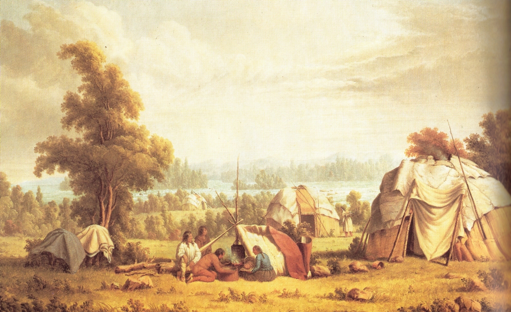
“Ojibwa village near Sault Ste Marie” by Paul Kane in 1845.
~ Wikipedia.org
Having chartered a Mackinac boat at the Sault St. Marie, and stored away our luggage, tents, provisions, with general camp equipage, &c., taking on board six able-bodied voyageurs, consisting of four descendants of Canadian French, and two half-breed Indians, (one of whom acted as our pilot,) we set off, on the 4th of July, at about 11, a.m., to coast it up the southern shore of Lake Superior, to Copper Harbor – a distance, by the way we were to travel, of over 280 miles.
The heat of the sun, combined with the attacks of musquitoes at night, annoyed us very much at first. I have seen what musquitoes are in many other parts of the world; but I never found them more abundant and troublesome than at some points on Lake Superior.
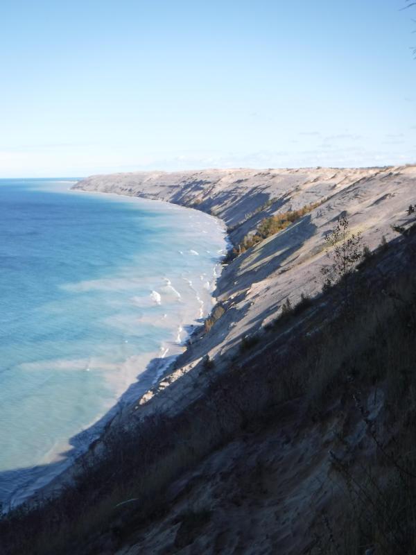
It took us eleven days’ voyaging to reach this place, travelling all day when the weather was favorable, and lying by when it became stormy, with strong head winds. At night we camped on shore, and generally rose every morning between three and four o’clock, being under way on the water as soon as it was light enough to see. In voyaging in this way, we had a better opportunity to view the country as we passed along, many portions of which were full of interest – such as the Grand Sable, the Pictured Rocks, &c. The former are immense cliffs, rising to the height of two hundred feet above the level of the lake, being composed of pure sand, and reaching about six miles in length along the lake shore, with its front aspects almost perpendicular. It is said, the sand of which they are formed maintains its perpendicularity by reason of the moisture which it derives from the vapor of the lake. The summits contain no vegetation, save here and there a solitary shrub or bush. The rest of this high, bold, and solemn mass stretches out, in silent and naked grandeur, beneath the horizon, forming a picture of desolate sublimity. We passed it late in the afternoon, during a bright and clear sky, when the sun had just begun to hide himself behind its huge masses.
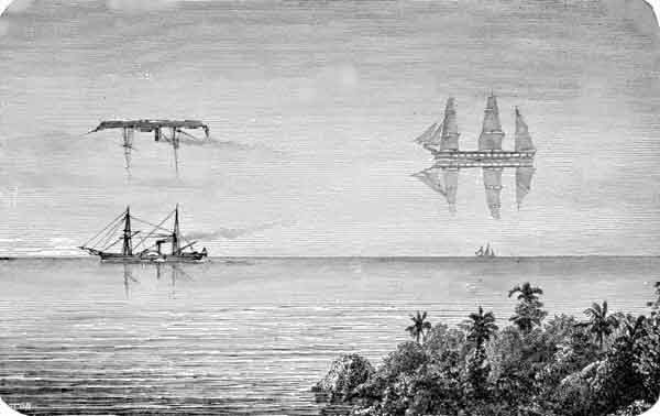
“Once a vessel was sailing over a northern ocean in the midst of the short, Arctic summer. The sun was hot, the air was still, and a group of sailors lying lazily upon the deck were almost asleep, when an exclamation of fear from one of them made them all spring to their feet. The one who had uttered the cry pointed into the air at a little distance, and there the awe-stricken sailors saw a large ship, with all sails set, gliding over what seemed to be a placid ocean, for beneath the ship was the reflection of it.”
~ Round-about Rambles in Lands of Fact and Fancy, by Frank Richard Stockton, 1910, page 277.
I have never travelled on a sheet of water where the effect of mirage is so frequently witnessed as on Lake Superior. For instance: early on Sunday morning, the 6th of July, soon after leaving our encampment, near White Fish Point, the morning being slightly foggy, we saw distinctly the Grand Sable, which must have been fifty miles in advance of us, with intervening points of land. I witnessed a similar instance of mirage when coming through Lake Huron. Early one morning, I distinctly saw Drummond’s island, which the officers of the boat assured me was eighty miles off!
I have never seen an atmosphere through which I could discern objects so far as on Lake Superior. Cliffs, headlands, islands, and hills, which often appeared as if within a mile or two of us, were found, on being approached, to be from five to ten miles off. Hence, in making what “voyageurs” called “traverses” – that is, a passage in a direct line from one headland to another, instead of curving with the shore of the lake – inexperienced voyageurs are very liable to be deceived, by supposing the distance to be short, when it is in reality very long. In making which, should a strong wind spring up from shore, a small boat would be liable to be blown out to sea, and the boat and people run the hazard of being lost. We had some brief but painful experience of this deception in apparent distance, by attempting one morning, after having camped at the mouth of the Dead river, to sail before what seemed to be a fair wind from Presqu’isle to Granite Point; but we had not made much over half the distance, when the wind suddenly changed to the west, and blew a gale on our beam, and we came very near being blown out into the open lake – which is just about equivalent to being blown into the Atlantic, for the storms are just as strong, and the waves roll equally as high. Finding we were going to leeward, we dropped sail, and took to our oars; and, although within half a mile of the point we wished to make, it took us hard oaring for about an hour to reach it.

“Pictured Rocks Splash © Lou Waldock”
~ National Park Service
I have never seen a sheet of water, where the wind can succeed in so suddenly throwing the water into turbulent waves, as on Lake Superior. This is owing to its freshness, making it so much lighter than salt water. One night, just as we had oared past a perpendicular red sandstone cliff a mile or two in length, where it would have been impossible for us to make a landing, and had reached a sand beach at the mouth of a small river, where we camped, the surface of the lake up to that time being as smooth as glass, we had no sooner pitched our tents, than a violent wind sprang up from the northeast, and blew a gale nearly all night, shifting from one point to another. In fifteen or twenty minutes after the commencement of the blow, the water of the lake seemed lashed into a fury of commotion, in which our boat could scarcely have survived.
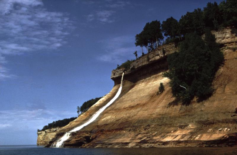
The grandest scenery beheld in the whole route was that presented by the celebrated “Pictured Rocks.” They lie stretched out for nine miles in length, a little east of Grand island. They are considered very dangerous to pass by voyageurs, who generally select favorable spells of weather for the trip.
“Grand Sable Dunes”
~ National Park Service
On the morning of Tuesday, the 8th instant, soon after leaving our camp, the fog cleared up, sufficient to give us a glimpse of these stupendous sandstone cliffs. As the sun rose, the fog became dispersed, and its brilliant beams fell upon and illuminated every portion of them.
They rise in perpendicular walls from the water of the lake shore, to the height of from 200 to 300 feet. They are so precipitous, that they in some places appear to lean over the lake at top, to which small trees are seen leaning over the lake, hanging by their frail roots to the giddy crags above. At one point, a small creek tumbles over a portion of them in a cascade of 100 feet in height. They stretch for nine miles in length, and in all that distance there are only two places where boats can land – one cove being called the Chapel, and the second Miner’s river.
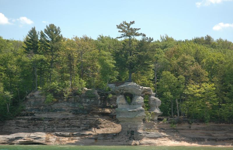
Photograph of “Chapel Rock” by David Kronk.
~ National Park Service
“Bridalveil Falls”
~ National Park Service
So deep is the water, that a boat can pass close along shore, almost touching the cliffs. Indeed, a seventy-four-gun ship can ride with perfect safety within ten feet of their base. Taken altogether, their solemn grandeur, and the awful sublimity of their gigantic forms and elevation, far surpass anything of the kind, probably, on the continent, if not in the world. Next to the Falls of Niagara, they are the greatest natural curiosity they eyes of man can behold. When steamboats are introduced on Lake Superior, they cannot fail to attract the attention of the tourist. They contain vast caves, one of which is only 30 feet wide at its mouth, but, on entering it, suddenly expands to 200 feet in width, beneath a lofty dome of 200 feet high. Different portions of the cliffs go by different names – such as the “Portailles,” the “Doric Rock,” the “Gros Cap,” the “Chapel,” &c. We went into a small bay at the base of the “Chapel,” which consists of an immense mass of rude sandstone, with trees growing on it, expanded in the form of an arch, its extremities resting on irregularly shaped columns, to the number of three or four under each end. Beneath the arch, a deep gorge enters the lake, crowded and choked with luxuriant vegetation. It appeared to me like the finest and most natural Druidical altar to be seen anywhere, not excepting even Stonehenge. Near the Chapel, a brisk little stream falls rapidly over the rocks into the water below. It is impossible to do justice to the splendid appearance of “the Pictured Rocks,” so called on account of the [???? ????? ???????] composed being mixed with iron ore, drippings from which they have stained the surface of the rocks with a variety of tints. The painter alone can convey any just image to the mind’s eye of these grand cliffs, and they will afford him a hundred views, every one of which will differ from the other. I will defy anybody to visit them, as we did, on a clear, bright day, when the lake is smooth, in an open boat, close by the side of them, without having his expectations of their natural grandeur far surpassed.
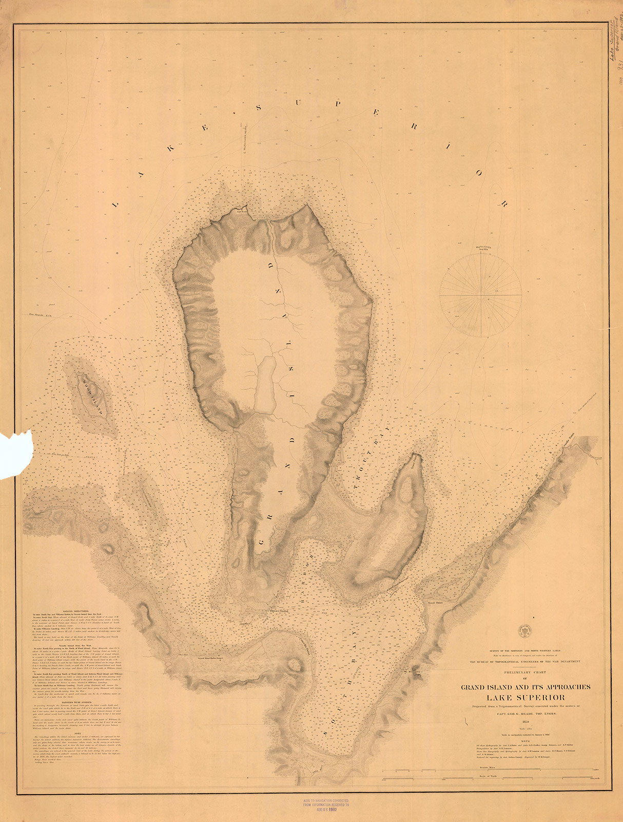
“Preliminary Chart of Grand Island and Its Approaches, Lake Superior, 1859″
~ Maritime History of the Great Lakes
Boats have sometimes been caught in the Chapel by sudden, high, and contrary winds, and compelled to remain there for three or four days, before being able to proceed. A few miles beyond the “Pictured Rocks,” we came to Grand Island, where, entering its harbor, we stopped at Mrs. Williams’s place, the only settlement on the island, which is very large. This is one of the most splendid and safe harbors on Lake Superior – perfectly land-locked on every side, and extensive enough to contain a large fleet of vessels, being easy of ingress or egress. From Grand Island we continued to persevere in our voyage, and finally reached Copper Harbor, via the Anse, in eleven days from the Sault Ste. Marie.
“The beginning of Methodism in the Upper Peninsula of Michigan west of Sault Ste. Marie is credited to the missionary trail blazers who came to Kewawenon, now known as Keweenaw Bay. The first, in 1832 with John Sunday a converted Canadian Indian. In 1833 Rev. John Clark continued the mission work started by Sunday. He was followed by Rev. Daniel Chandler in 1834 who remained here for two years. Rev. Clark was appointed Superintendent of Lake Superior Missions in 1834 and was instrumental in having a mission house and church school house erected during Rev. Chandler’s mission stay. Houses for the local natives were also erected along the lake shore in the vicinity of the present Whirl-I-Gig Road”
At the Anse we fell in with Mr. Ord, the United States Indian agent at the Sault Ste. Marie, who was on a visit to the Indians at that point, to take the census, and to hold a talk with their chiefs in council. We arrived at the Anse a few hours before the council began. The chiefs all sat around a hall on wooden benches, while Mr. Ord, with the interpreter, was seated at the head of the circle. Many of the Indians were fine-looking men. They had a great many petty grievances to relate to the agent, who listened to them with patient attention. The Chippewas about the Anse are said to be much better off than those who trade to La Pointe, at the upper end of the lake.
The Methodists have a missionary station and school on the east side of the bay of Keweewena, and near its head; around which there is an Indian village, consisting of 600 or 700 souls. The Catholics have also a missionary station on the opposite side of the bay, which is here only about a mile or two wide.

Reverend William Hadley Brockway: “The first Methodist minister licensed to preach in the State of Michigan.”
~ Geni.com
The government employs at this Indian post one blacksmith, (Mr. Brockaway,) one carpenter, (Mr. Johnson,) and one teacher, in the person of the Methodist minister. We left the Anse about half-past 4 o’clock, p.m., sailing before a fair wind, reaching the mouth of the Portage, or Sturgeon river, where we camped on a flat point of land severely infested by musquitoes, with the heat equal to any in intensity (which had prevailed during the day) that I ever experienced. At Fort Wilkins, Copper Harbor, on the same day, I have since learned the mercury rose to 100° in the shade. This would seem to be a tremendous degree of heat for such a high latitude, the fort standing on the parallel of 47° 30′.

Detail of “Keewaiwona Bay” with “Anse” and the “Old Indian Village” from Map of the Mineral Lands Upon Lake Superior Ceded to the United States by the Treaty of 1842 With the Chippeway Indians.
~ Wisconsin Historical Society
During the night, we could occasionally hear the plunges of sturgeon floundering in the water, which abound in this lake river. A thunder-storm, also, passed near, before day, which had the effect to cool the air. About half-past 1 o’clock, I was awakened by the loud talk and whooping of Indians, carried on between our Indian half-breed pilot, Jean Baptiste, and a lot of freshly-arrived Indian voyageurs, conducted in the Indian dialect. On looking out of our tent, I discovered a plain-dressed Yankee-looking man, standing in front of it. On hailing him, he proved to be the Rev. Mr. Brockaway, a Methodist minister, and superintendent of Indian missions in this part of the world. He had been on a visit to the missions at the upper end of the lake, and was returning to the Anse, which he was anxious to reach in time to attend to Sunday morning service, (the next day being Sunday,) and from whence he expected to proceed to the Sault Ste. Marie, where he is stationed in the capacity of chaplain to the garrison at that post. He said he had, on reaching our encampment, travelled that day from the Ontonagon river, 80 miles distance, in a bark canoe, accompanied by four Indian voyageurs. After the Indians had prepared some food, with tea, of which Mr. B. and themselves partook, they again set off for the Anse, about 15 miles from us, where they must have arrived at a very early hour. This despatch far exceeded the expedition of our movements, and displayed unusual activity on the part of the enterprising missionary of an extensive and practical church organization.
We rose at three a.m., and in half an hour were under way on the lake. In these latitudes it is light at three in the morning; twilight continuing till eight and nine in the afternoon.
The following night we camped near the mouth of Little Montreal river, in full view of the high mountains or large round hills of trap rocks running along the peninsula of Keweewena towards its extreme point, some of which rise to the elevation of eight hundred feet above the level of the lake.
The next day, after some detention, we reached Copper Harbor, and landed near the United States Mineral Agency on Porter’s island, where we found quite a village, consisting of white canvas tents of various sizes and forms, occupied by miners, geologists, speculators, voyageurs, visitors, &c.
The only tenement on the island is a miserable log-cabin, in which General Stockton, for the want of better quarters, is compelled to keep his office. The room which he occupies, is only about eight feet square – just large enough to admit a narrow bed for himself, a table, and two or three chairs. In this salt-box of a room, he is compelled to transact all the business relating to the mineral lands embraced within this important agency. As many as a dozen men at a time are pressing forward to his “bee gum” apartment, endeavoring to have their business transacted.
The office of the surveyor of this mineral lands, in charge of Mr. Gray, at this agency, is still worse adapted to the transaction of public business. He is compelled to occupy the garret of the log-cabin, with a hole cut through the logs in the gable to serve as a window. In this garret he is obliged to have all his draughting performed, subject to the constant interruption of parties wishing to see plans of the mineral lands. It would seem almost impossible, under such circumstances, for the officers to avoid making mistakes; yet, by dint of unwearied labor and attention to their official duties, they have conducted their affairs with an accuracy and despatch highly creditable to them.
The government has been fortunate in the selection of its agents in the mineral region of Lake Superior. To untiring industry, punctuality, and close attention to business, they unite, in a high degree, the bland, mild, and patient bearing of gentlemen.
Gen. Stockton’s labor are severe and perplexing. He is continually beset by crowds of applicants for locations, all anxiously pressing forward to secure leases for copper-mines – among whom are found some utterly reckless of all principles of justice and equity, who endeavor to bend the agent into a compliance with their unjust and unreasonable demands – such as wishing him to supersede prior locations for their benefit, or to grant locations evidently intended to cover town sites, beyond the bounds of his agency, where no mineral exists, which he has no authority to grant; and because he has, in every instance of the kind, resisted their unreasonable applications, he has not escaped making a few enemies among such persons, who are collecting together to abuse and misrepresent him. Considering the cramped quarters furnished him by the government, and the great rush of people upon him from all quarters, under the excitement of a copper fever raging at its height, and many anxious to obtain exclusive advantages, it is surprising how he has succeeded so well as he has done in giving such general satisfaction. His official duties are discharged with a promptitude, fidelity, firmness, and impartiality, which are creditable to the public service. He seems peculiarly fitted, both by habit and nature, for the discharge of the responsible duties involved in the administration of an agency established in a wild an uninhabited country, being traversed at present by bands of people in search of mineral treasures, as diversified in character, dispositions, &c., as the various sections of country from whence they come – many of whom are by no means scrupulous as to the means for promoting their own interest – who probably suppose they can play the same game in the copper mineral region that was practiced in the early leasing of the lead mineral districts of Illinois: that is, seize upon government lands, work and raise mineral ore, cheat the government, and sell rights, where they have never had a claim.
It is enough to say that, while such men as Gen. Stockton, Major Campbell, and Mr. Gray, remain in office on the southern shore of Lake Superior, all such desperadoes will be completely foiled and disappointed. The frauds committed on the government in the working of the lead-mines, cannot be repeated in the copper mineral region of the United States. When fraudulently-inclined adventurers find they cannot make the faithful officers of government stationed in this quarter swerve from the strict and impartial discharge of their duty, they will probably unite for the purpose of operating upon government to procure their removal, and endeavor to get men in their places more likely to act as plaint tools in promoting their selfish ends.
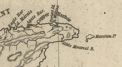
Detail of Porter’s Island, Fort Wilkins, Copper Harbor, Agate Harbor, Eagle Harbor, and Little Montreal River along the tip of the Keweenaw Peninsula from Map of the Mineral Lands Upon Lake Superior Ceded to the United States by the Treaty of 1842 With the Chippeway Indians.
~ Wisconsin Historical Society
The agency being on a narrow small island, half a mile from the mainland, makes it very inconvenient. The island does not afford sufficient timber for fire-wood, and in winter is isolated by ice, &c. It should by all means be removed to the main shore, and placed near Fort Wilkins, which is nearly two miles distant on the main land, or removed up to Eagle Harbor, which is a far preferable and more convenient site for the agency.
There is no question by the great range of trap-rock, running parallel with the southern shore of Lake Superior for a great distance, is [????????] with many valuable veins of copper ore; but to find them and develop them, must be the work of time. The impenetrable stunted forest seems to be little else than a thick, universal hedge, formed by the horizontal interlocked limbs of dwarf white cedars, intermingled with tamarack, birch, and maple. Persons who attempt to penetrate through them, without being protected by a mail of dressed buck-skin, have their clothes soon slit and torn from their bodies in shreds.

Painting of Professor Douglass Houghton by Robert Thom. Houghton first explored the south shore of Lake Superior in 1840, and died on Lake Superior during a storm on October 13, 1845. Chequamegon Bay’s City of Houghton was named in his honor, and is now known as Houghton Falls State Natural Area.
Dr. Houghton says, so considerable is the attraction of the trap-rock for the needle, that, on many places, when surveying over its ranges, he cannot rely upon it, and is compelled to run his lines by the sun and stellar observations.
So far as practicable mining operations have progressed in the country, the following seems to be the result:
At Eagle river several locations are being worked, superintended by Col. Gratiot, and on which from 70 to 80 men are employed.
At Agate Harbor another company have this season commenced operations under the direction of Mr. Larned, of New York, in whose service from 15 to 20 laborers find employment.
At Copper Harbor a company from Pittsburg are working a vein of black oxide of copper, under the superintendence of Dr. Pettit, who has from 30 to 40 hands employed under him. Besides these, there are other small parties at work in various directions. So that it would appear that mining in the United States copper mineral lands has fairly commenced.
Up to this time, the returns made to the agency by two of the above companies – the Eagle River, alias Boston Company, and the Pittsburg Company – amount to the following quantities of ore: The former have raised 500,000 lbs. of ore, worth not less than $125 per ton. The latter company have raised 6,670 lbs. of the black oxide copper ore, the value of which I do not exactly know.
Other companies are organizing for mining purposes, and will probably commence operations the present, or early in the next season.
The country still in the possession of the Chippewa Indians, embraced between the northwestern part of the lake and the British frontier, along Pigeon river, might be easily obtained from them by treaty. And, if poor in mineral wealth, it is a very rich soil and a good agricultural country; and by its acquisition we should at once extend and square out our possession and settlements to the British frontier, which should be protected by detached forts, extending along our lines, towards the Lake of the Woods. According to the present Indian boundary, it is made to pass along the water-line of the lake shore, from Pigeon river, around Fond du Lac; and when some distance east and south of the lake, strikes a straight line west from the Mississippi. The United States, by being cut off by this water-line from all landing sites for harbors or fortifications for one or two hundred miles of the western and northern shore of the lake, will be subject to great inconvenience.
The number of persons at present exploring or visiting the mineral region of Lake Superior, is supposed to amount to five hundred or more. The water of the lake, especially in deep places is remarkably fine and cool for drinking. The surface of the water in the upper part of the lake is said to be 900 feet above the level of the Atlantic. The shores of this great lake are, at many places, bold, high, grand, and solitary – the favorite resort of large eagles, several of which we saw – one, in particular, was a splendid specimen of the bald eagle. The lake abounds in white fish, trout, siskomit, and bass.

The Siscowet, or Fat Trout, is a subspecies of Lake Trout. Drawn by David Starr Jordan, and Barton Warren Evermann, 1911.
~ University of Washington
We caught fine trout almost every day during our voyage, by trailing a hook and line at the end of our boat. On the 13th inst., (the day before reaching Copper Harbor) we caught four fine large trout.
The scenery, climate, &c., of Lake Superior, strike the traveller as being peculiar, and something very different from what is met with in any part of the United States. Game is not abundant. With the exception of a porcupine, and a squirrel or two, we succeeded in killing nothing. Wild fowl, pigeon, and ducks are more plentiful. we killed many of the former, and two pheasants, during our trip. Our half-breed Indians skinned and dressed our porcupine for us, whose flesh we found quite palatable.
At one point I purchased the hind-quarters of a beaver, which some Indians had killed. The tail being considered a great delicacy, I sent it to Mr. Ord and party, who were then travelling in a separate boat, in company with us. We found the beaver meat, when dressed, most delicious food.
Our party, although sleeping in and exposed to showers for a day or two, all enjoyed excellent health. Many voyageurs are attacked with dysentery, but it is very slight, and easily overcome by the use of simple medicine.
I remain yours,
Very truly and respectfully,
MORGAN.
To be continued in The Copper Region…
By Amorin Mello
A curious series of correspondences from “Morgan”
… continued from To The Far West.
The Daily Union (Washington D.C.)
“Liberty, The Union, And The Constitution.”
July 7, 1845.
MADISON, (W.T.,) June 26, 1845.
To the Editor of the Union:
SIR: Our democratic territorial convention has this day nominated the Hon. Morgan L. Martin, of the county of Brown, as the candidate for the delegacy, to succeed Governor Dodge. Mr. Martin is one of our ablest and most reliable democrats, and there is but little doubt of his election by a triumphant majority. Mr. Martin has been fourteen years in the upper branch of our territorial legislature, and has been the presiding officer of that body at four sessions. The democrats of the Territory will go into the canvass in the best possible spirits, and with the fullest confidence of success; for they are well united, and have a candidate worthy of the cause and their most zealous support.

Henry Dodge
~ Wikipedia.org
More than twice the number of immigrants are arriving here daily, this season, than have ever come at any previous season. The administration of Governor Dodge is very popular with all parties, and so are the measures of the national administration, and particularly its course on those two great questions – the annexation of Texas, and the maintenance of our rights to Oregon.
The convention was very fully attended; and, although there was some division when it assembled, as to who the nominee should be, the members left here in the best possible spirits. In haste.
Yours, truly,
J. A. N.
The Daily Union (Washington D.C.)
“Liberty, The Union, And The Constitution.”
July 8, 1845.
[From our regular correspondent.]
MACKINAC, June 29, 1845.
This small town stands on a narrow slip of land sloping from the foot of elevated bluff hills in the rear, to the water. The second and highest elevation is about three-quarters of a mile in the rear of the town, and is three hundred feet above the level of the lake or straits, and nine hundred feet above the level of the ocean. The site of the town winds in a crescent form around a small harbor, indented in the southeastern part of the island.

Painting of Fort Mackinac by Seth Eastman in 1761.
~ United States Army Center of Military History
The old Fort Mackinac stood on an extreme northern point, putting out into the strait from the southern main land, some 10 or 15 miles to the southward of this place. It was first settled upon as a French missionary station, and a fort erected. When Carver visited it in 1756-’57, the fort was garrisoned by the English, who came into possession of it with the conquest of Canada, a few years before. It then contained 30 houses, and had one hundred men in garrison, besides a government-house, &c. In 1763, the various northwestern tribes of Indians who had long known the French as the first Europeans they had ever formed friendly intercourse with, became highly dissatisfied with the change from French to English rule. A powerful league was, therefore, formed between the Ottowas, Chippewas, the Hurons, Menomonees, &c.; and the celebrated Pontiac was their leader, who bore a deadly hostility to the English.
!["No authentic images of Pontiac [also known as Obwandiyag] are known to exist. This interpretation was painted by John Mix Stanley." ~ Wikipedia.org](https://chequamegonhistory.com/wp-content/uploads/2016/04/pontiac-chief-artist-impression-414px.jpg)
“No authentic images of Pontiac [also known as Obwandiyag] are known to exist. This interpretation was painted by John Mix Stanley.”
~ Wikipedia.org
After peace was made with Pontiac, the fort came again into the occupancy of the English, who transferred it to us, under the treaty of peace, at the close of the revolutionary war. When the late war broke out, the British took both old Fort Mackinac and the fort at this town, and held them up to the treaty of Ghent; and if war were to begin soon, they would inevitably fall into their hands again, owing to our neglect to fortify them in a proper manner. The old site we have abandoned, and erected a small and well-built fort on the hill, just in the rear of the town, on the island, which is about one hundred and fifty feet high above the level of the lake, or strait. About three-quarters of a mile behind the fort, there is a high hill – the highest on the island – with its steep face looking towards the fort and harbor, while its eastern and northern section extends over a narrow plateau, or level, which could be completely raked by guns stationed on the walls of a fort, which should, by all means, be erected near the brow of the hill. This high point of land overlooks and completely commands the fort our troops (two companies) at present occupy.
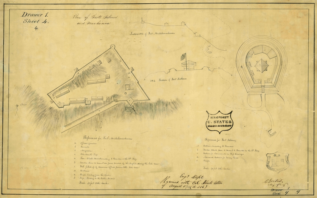
“Major Charles Gratiot visited Mackinac Island in 1817, using his trained engineer’s eye to carefully record the design of Fort Holmes in these detailed plans. The fort’s blockhouse, walls, and gun platforms are clearly visible on Gratiot’s drawings”
~ Mackinac State Historic Parks
The first news the people heard of the declaration of war in 1812 in Mackinac, was the appearance of a large body of English and Indians on the high hill, who commanded the surrender of the fort, then garrisoned by some fifty or sixty men which was complied with. The English entrenched this high ground, planted some batteries on its ramparts, and named it “Fort Holmes,” which it still bears.
This point is the main key to those important straits which connect two of the great lakes. It is now just in the state of ruins in which the British left it in 1814-’15; and why our government have not strongly fortified it, seems inexplicable. If this hill were strongly fortified, with armed outposts at some other points about the straits, the military defences of this place would be wholly impregnable – even stronger, if anything, than the rock of Gibraltar. The position is a most important one and government should lose no time in putting it in a complete state of defence.
The only communication by water, between the two great lakes of Michigan and Huron, is directly in view of the heights of this harbor.
From the hill of Fort Holmes, there is a most magnificent view. The great sheets of water in the straits, with the islands, distant main-land, &c., are all in full view. The approach of a steamer or vessel can be seen when from twelve to fifteen miles distant, in the eastern or western offing.
This post was first settled in 1764 – the year after the fall of old Mackinac. In 1796 it was conveyed by the English to St. Clair. It has long been a celebrated Indian trading-point, and is so yet; large numbers of whom constantly visit the place in the birch-bark canoes, encamping beneath bark wigwams (or shanties) on the stony beach along the shore.
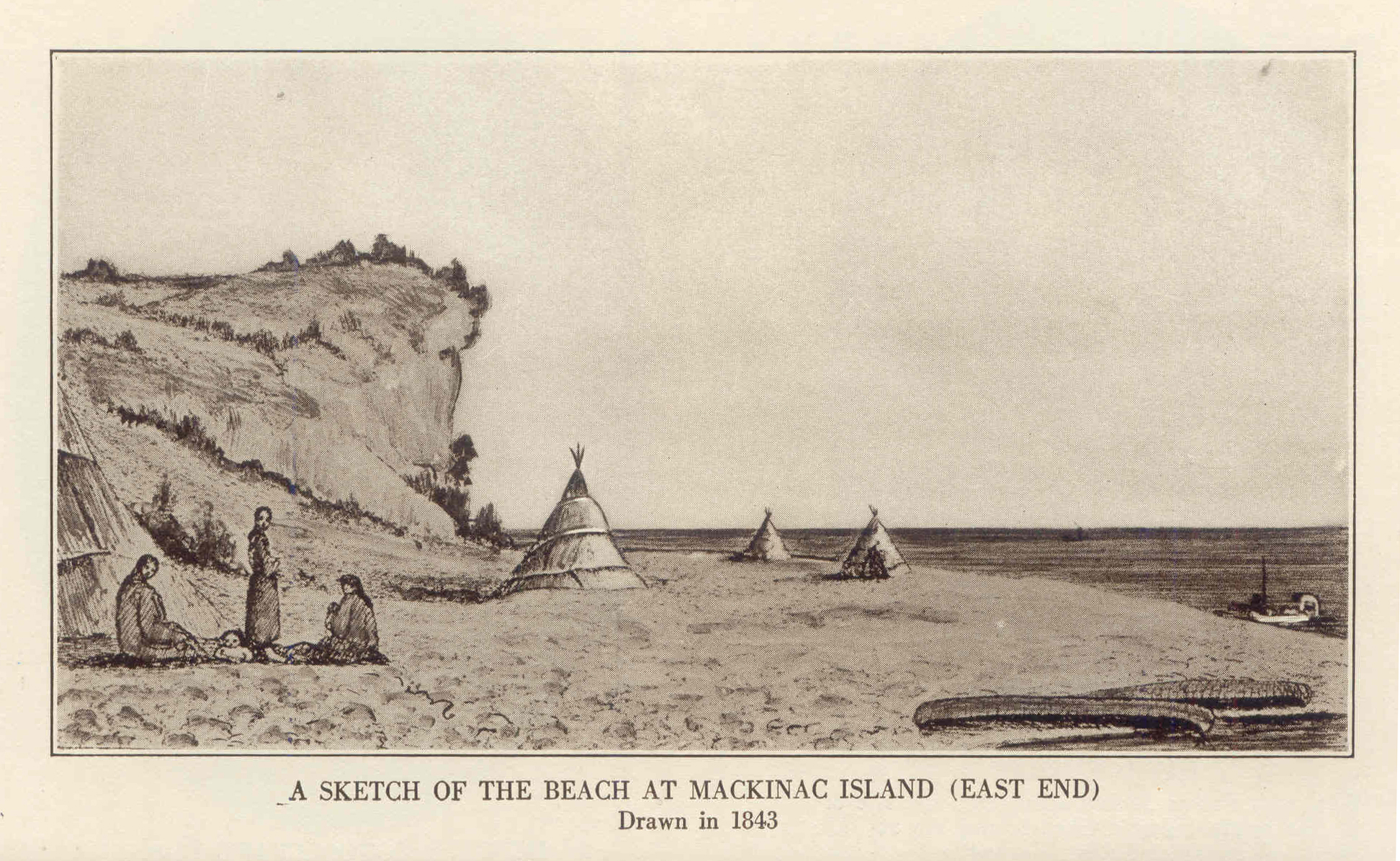
1843 Drawing of Mission Point Beach at Mackinac Island, Michigan
~ Historic Mackinac, Volume 1, facing-page 367.
This is also a great point for catching lake trout, or salmon-trout, white fish, &c., which are salted down in barrels, and shipped to market, selling for about seven dollars per barrel, on average. This business is in the hands of Indians, half-breed Indians, and French fishermen, who go out into the lakes in Mackinac boats, properly prepared with seines, hooks, &c.

Photograph of Arch Rock on Mackinac Island, by n8huckins, shared under Creative Commons.
~ Wikipedia.org
The island of Mackinac is about 9 miles in circumference, and contains several natural curiosities among which, is the Giant’s Arch, or Rock, about a mile northeast of the town. It is 100 feet high – the natural arch having a span of 45 feet wide.
Nearer the centre of the island is Henry’s cave, at which, it is said, this traveller once saved his life from the fury of drunken Indians, by secreting himself in it. It was then full of bones, which have since disappeared.
In the town of Mackinac, there are two small churches, the most ancient of which is a Catholic chapel, connected with a Catholic mission at the point. The other is a small Protestant church, originally built in connexion with an extensive mission-house founded by the Presbyterian Board of Foreign Missions. They have since changed the establishment to the shores of Lake Superior. The mission-house is now occupied by Mr. Herrick, lately from Detroit, who has converted it into a large and commodious tavern, at which we are staying. There is also another comfortable hotel in the place.
I know of no place on the continent that can make a more delightful summer residence than Mackinac. The heat of the summer is scarcely felt here at all. You can sleep under a blanket every night throughout the summer.
The drinking water is equal to, if not better than, any which ever gushed from the hill-sides of the Alleghany mountains. The fish are abundant and delicious. Large steamers running between Buffalo and Chicago pass twice daily, touching in each case.
The American Fur Company have an agent here. The United States government have an Indian sub-agent, also resident at this place.
I went to a small Catholic church to-day, where I heard a short sermon in French. The auditory consisted of French descendants, Indians, half-breeds, and some few Americans.
This island is called the county of Mackinac and Sate of Michigan. I believe, in addition to a State court, the United States district judge occasionally holds a court here.
We leave to-morrow, on the steamboat General Scott, expected up to-night from Green bay, for the Sault de Ste. Marie – the place of rendezvous for persons bound up Lake Superior, on which then is no craft at present, except two or three schooners sailing up the lake from the Sault to Copper Harbor, &c.
When I arrive at the Sault (pronounced Soo) Ste. Marie, I will write you again.
I remain yours, very respectfully.
MORGAN.
The Daily Union (Washington D.C.)
“Liberty, The Union, And The Constitution.”
July 16, 1845.
EDITOR’S CORRESPONDENCE.
—
[From our regular correspondent.]
SAULT STE. MARIE,
Near Lake Superior, July 2, 1845.
We left Mackinaw yesterday, the 1st July, about a quarter-past eight , a.m.; our course for forty miles to the “detour” lying through the open and upper part of Lake Huron, which exposed our little boat to a very heavy rolling sea- the result of the previous day or two’s severe blow on the lakes. Many of the passengers, as usual on such occasions, became severely sea-sick. At half-past 12, p.m., we rounded into St. Mary’s river, where we had smoother water.

“A painting by Paul Kane depicts an encampment on the shores of Lake Huron in about 1845.”
~ The Granger Collection, New York
The river at first appeared very wide, with a low and sandy beach on each side, and a flat swampy country running back into the interior. As we progressed, however, the stream grew more narrow, and again expanded into two smart lakes – the first called Great George, and the latter Little George’s lake. Leaving these lakes, the river fifteen or twenty miles below the Sault again contracted, and turned about among high hills a little distance off, while its margin was skirted with low, falt, gravelly ground, covered with white cedar and other rather dwarfed forest trees. These highlands showed steep hills or knobs of old red sandstone.
It was not long after passing the hills, before we hove in sight of the white and frothy rapids, at the foot of which stands the small village of the Sault, at the principal pier of which we landed – it being 60 miles from the lake.
The town exhibits a collection of wooden log-houses, roofed and weather-boarded with birch bark, gathered along the river at the foot of the falls, here and there showing small framed painted houses, one of which is an hotel, at present overflowing with people bound for the mineral lands of Lake Superior.
The Sault contains, besides the houses noticed, a small United States garrison; the slender wooden stockade defences of which, with officers’ quarters, are almost in a state of dilapidation. There is also a small missionary station and school-house belonging to the Methodists, and a U. S. Indian agency.
A painting of an Ojibwa village near Sault Ste Marie; also by Paul Kane in 1845.
~ Wikipedia.org
There is a collector of the port on each side of the river, which is here about a mile wide, between us and Canada. I imagine there is very little business to do by either functionary. The American Fur Company have a station at the Sault. The Hudson Bay Company have a factory, or station, on the opposite side of the river. I paid a visit to the latter yesterday, having a note of introduction to a Mr. Blenden, their agent, whom I found busy in packing up for a voyage up the Canada side of Lake Superior. He is bound on a tour among the posts towards Hudson’s Bay to the north. Mr. B. received me very politely. He informed me that he intended to carry his children with him, whom he expected to send in the care of friends across to Hudson’s Bay, where they would embark on one of the company’s ships for London, and be from thence conveyed to Edinburgh, to be placed at school. He told me Sir George Simpson, the governor of the company, had passed up the lake not long since, accompanied by his boats, &c. he was bound for the valley of the Red river of the North, where he expected to meet a kind of convention of the authorities of the company’s territories in that quarter – among whom would be the representatives of Selkirk’s colony, the population of which is about 5,000. They produce more grain, &c., than they can find means of having conveyed to market: hence there is some emigration from their colony to the valley of the Mississippi, within the States.
Mr. B. states that the Hudson Bay Company employ about seven ships in their trade – two or three of which, every summer, visit Hudson’s Bay; three double Cape Horn, and ascent the Columbia river; and one or two others are employed at other points. He states that their charter gives them ample territorial jurisdiction over all the lands, mines, &c., on the high lands to the north and west of Lake Superior, but not over the lands immediately along the shore. He states that a geologist, Dr. Logan, is engaged in surveying the country of Upper Canada, and is now employed between Lake Ontario and Lake Huron, or the inlet of the latter lake, called Lake Georgina Bay. He is expected up this summer, to examine the northern shore of Lake Superior, which is supposed to be as rich in copper ore, at certain points, as the southern shore.
The two fur companies (American and Hudson Bay) are on the best possible understanding; which has a very favorable influence on the northwestern tribe of Indians.
In 1830, they mutually agreed to exclude all intoxicating drinks, in their traffic and intercourse, from them. The Indians, in consequence of this wise and humane compact, are everywhere, within their bounds more inoffensive and peaceable. It is just as safe, if not more so, to travel among them, than among the whites. They have a considerable number of birch-bark lodges at the Sault, employing their time in catching fish at the foot of the falls, in their gill-nets. They belong almost exclusively to the Chippewa tribe. The Sault is the greatest place for catching fish I ever saw. They can take ten times as many white fish, salmon-trout, brook-trout, bass, &c., as can be disposed of. The Indians push their canoes up into the foam of the falls, cast forward their nets, and draw it as the current carries the boat down again. Our staple article of food at the Sault is fresh fish.
The falls here, or rapids, have only a descent of about 18 to 21 feet in a mile; while the ground is very favorable to the construction of a ship-canal – the length of which need only be a mile. On the Canada side, the length of the rapids is only about three-quarters of a mile long. It is very likely, if our government refuses to construct a canal on our side, that the English may, ere long, make one on their side; which will be only three-quarters of a mile long.

“Hudson Bay Fort, Sault Ste. Marie. By J.S. Hallam.”
~ Sault Ste. Marie Public Library
The fort at this place, in time of war, should be erected on a considerable hill, about three-quarters of a mile in the rear of the Sault, called Coal-pit hill; which commands a fine view of the falls, river, &c.
There are several schooners (say three or four) on Lake Superior, plying between the head of the falls and Lapointe, Copper Harbor, &c. They have been drawn around the falls on rollers. There is some talk of having a steamer carried around by the same means. A fine new vessel is on the stocks at the head of the falls, which is about half done. It will be launched about the 1st of August. She is building by Newbury & Co.; to be rigged as a fore-and-aft schooner.
At the Sault, a Catholic station was founded from one to two centuries ago, being fixed upon as a missionary station. next to Quebec and Montreal, it is said to be the oldest point settled upon by Europeans in Canada. It has always been an important point for the Indian trade. Here goods are carried round the falls, and sent up Lake Superior to be distributed to various Indian trading-posts, far in the northwestern region of the continent.
The early Catholic Jesuits, or priests, who first explored the far distant, cold, and deary regions bordering the shores and streams of the upper lakes, must have been animated with a deal of perseverance, and influenced by the dictates (to them) of an all-powerful religion. They at every prominent point throughout this vast country erected the cross among the savage tribes, and impressed their minds with the solemn and imposing ceremonies of the religion they professed. Their success among the savage tribes of North America has never been surpassed, if equalled, by more modern and persevering denominations. They acquired an influence over the Indians, which nearly a century of British and American domination has not been sufficeint to efface. Even at this day, the frail wooden cross seen standing in the humble grave-yards of the Indians, sufficiently attests the remaining influence of the Catholic religion. French and Indian have also intermarried more than the Anglo-Saxon and Indian. The latter also more commonly speak French. Indians never, in early times, fought Frenchmen. Our earliest accounts of the vast interior western and northwester regions of this continent were derived from Catholic priests, such as Father Hennespin, &c.
The first Englishmen who explored the upper lakes after the fall of Canada, were Henry and Carver, between the years 1766 and 1775-’76. Their works contain many interesting details relative to the country.
In alluding, in a former letter, to our loss of Hunters’ island by the treaty of Washington, I underrated its size. It is greater in area than the vaunted Isle Royale; being about 50 miles long, instead of 40, and about 40 wide.
A gross error prevails with regard to Isle Royale. It is supposed by some that we acquired it by the Lake Washington treaty, when it has always been ours, since the treaty of peace after the revolution. We have, therefore, given away important territory on Pigeon river, without receiving any equivalent, that I know of.
We have been wind-bound at the Sault for two or three days, by reason of a strong northwester, blowing directly down the river. It has been blowing about a half a gale on the upper lakes for nearly two months past; and, from all indications, the gale may last all summer. The weather in this latitude 46 degrees 30 minutes) is very cold. We have to wear thick woollens and sleep under blankets – it being difficult, on the 2d day of July, 1845, to keep warm at that! The soil produces fine Irish potatoes – better than I have tasted anywhere else – some oats, barley, turnips, rye, and wheat, &c. The soil is miserably bad, back in the interior. The population depends chiefly upon fishing, for a support; which, to all appearance, is a never-failing resource.
From this point, I expect to coast the southern lake shore in an open boat, with five or six “voyageurs;” or send them on, and go up to Copper Harbor in the schooner Swallow.
I shall pass to where mail facilities cease, and where the reduction of postage affords no benefit; and it may be some days before you can get another letter from me.
During the late war, the Americans, under command of Major Holmes, burnt down the Hudson Bay Company’s fur agency, or factor, on the opposite site of the river.
Almost the only tribe of Indians visiting or living about the Sault, belong to the Chippewa tribe – which, on the average, are good-locking Indians, and apparently comfortably clad, &c. Many of the half-breeds are really beautiful; and, in regularity of features, figure, and size of hands and feet, would do credit to more civilized life. They seem to me to be more industrious than more southern tribes of Indians among whom I have travelled, and far more inoffensive and civil to the whites. Some of the men are exceedingly tall and fine-looking fellows. I saw yesterday the son of a chief from the Canada side, who stood between six and seven feet high, and was as straight as an arrow. He could not speak a syllable of English. I saw him examining, with much attention, the new schooner building at the head of the falls.

The USS Michigan was launched in 1843, and later renamed as the USS Wolverine in 1905.
~ Wikipedia.org
The names of Indians are often very curious, and, in a measure, put at defiance the power of the English language to express them. I saw a tall man of the Chippewas at Mackinac, as he stood gazing at the United States steamship Michigan. Mr. Biddle, an old resident trader of the place, who spoke Chippewa, was standing near him. he wished to know of Mr. Biddle what sort of a vessel she was; who explained to him that she belong to “his great father, the President, who, if necessary, would use it against his enemies.” This Indian’s name, translated into English, was nothing less than “A Corpse,” or “A Dead Man” – an unusual name, I should think, even for an Indian!
The Indians always keep an abundant supply of dogs, which, about the Sault, seem uniformly to be a cross of the common cur with the wolf, and seem of little use, except to keep up an eternal barking at night about their bark lodges. This is a remarkably fine climate for the Newfoundland dog, some fine specimens of which I have seen in the possession of the whites about the Sault. At Mackinac, and other places in the northwest, the half-breeds especially make draught animals of dogs, in drawing water on trucks, and in performing other labor.
The dogs used by the Indians about Hudson’s Bay are said to be larger and more savage, and used to a greater extent as animals of labor.
The Chippewas, it is said, make no scruple of eating dogs, which they often esteem as a delicacy. This, however, I cannot vouch for.
Yours, very respectfully,
MORGAN.
