Judge Bell Incidents: King No More
October 16, 2025
Collected & edited by Amorin Mello
This post is the second of a series featuring newspaper items about La Pointe’s infamous Judge John William Bell. Today we explore obituaries of Judge Bell that described his life at La Pointe. Future posts of this series will feature articles about the late Judge Bell written by his son-in-law George Francis Thomas née Gilbert Fayette Thomas a.k.a G.F.T.
… continued from King of the Apostle Islands.

Wisconsin State Journal
Saturday, December 31, 1887, Page 1
King of the Apostle Islands No More
ASHLAND, Wis., Dec. 31. – Judge Bell, known far and wide as “King of the Apostle Islands,” died yesterday. For nearly half a century he governed what was practically a little monarchy in the wilderness. He was 83 years old, and was the oldest living settler on the historic spot where Marquette founded his mission, two hundred years ago.
The Saint Paul Globe
Saturday, December 31, 1887, Page 1
KING OF THE ISLANDS.
Judge Bell,
“King of the Apostle Islands,”
Has Given Up His Crown.
The Oldest Living Pioneer
of the Historic Spot
Dies in Apparent Poverty,
Special to the Globe.

San Francisco Examiner
Wednesday, January 3, 1888, Page 2
ASHLAND, Wis., – “The king of the Apostle islands” is dead. He passed away at an early hour this morning at La Pointe, on Madeline, the largest of the group, where he has lived for forty-four years, the oldest living pioneer of the historic spot where Pere Marquette founded his little Indian mission 200 years ago. Judge Bell was a character in the early history of the Lake Superior region, known far and wide as the “king” of the country known as La Pointe, which was organized in 1846 by Judge Bell. The area of the country was as large as many states of the Union, its borders including nearly all of Wisconsin north of the Chippewa river, the Apostle islands and to an almost
ENDLESS DISTANCE WEST.

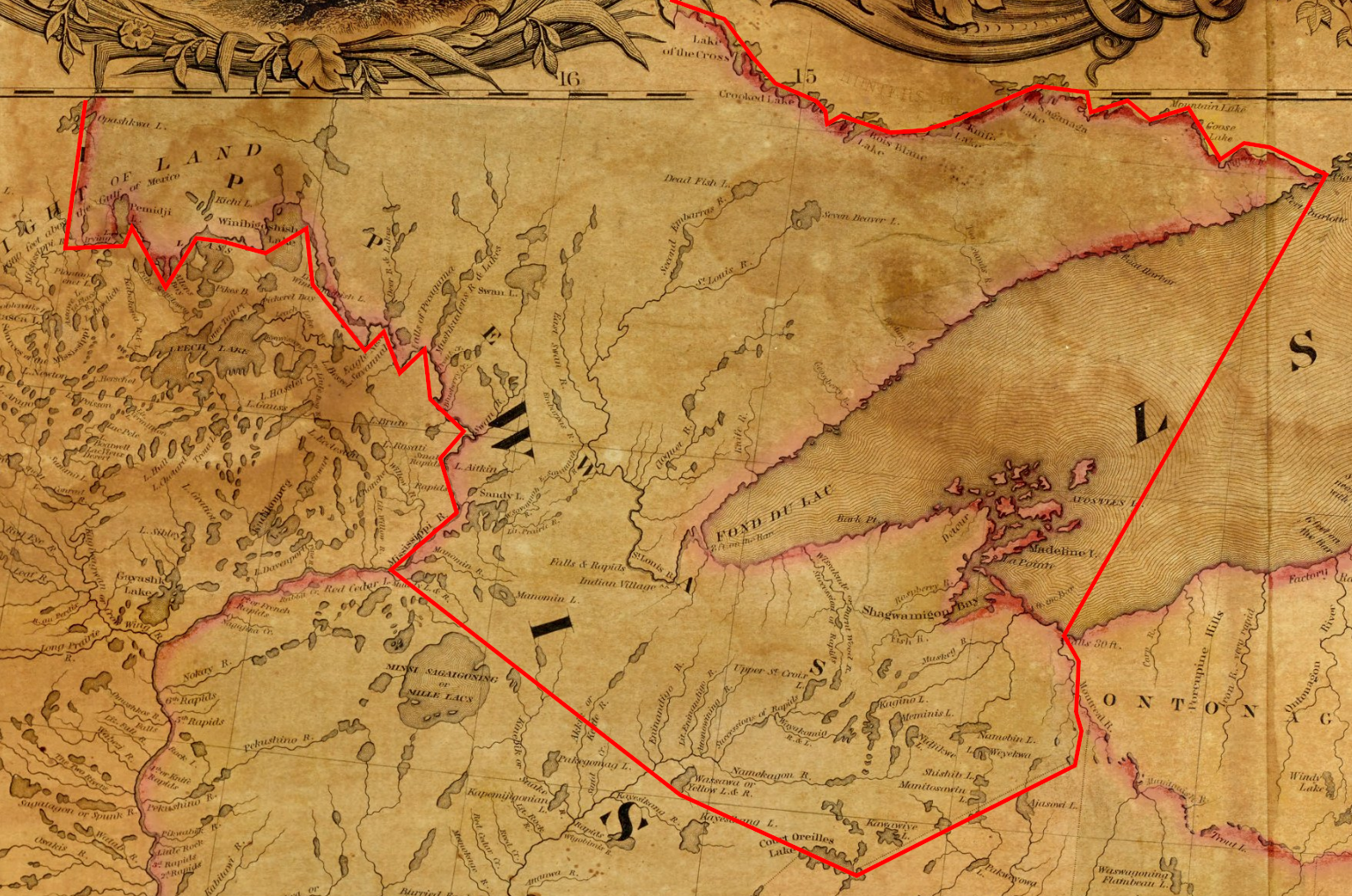
Wisconsin Historical Society’s copy of Lyman Warren’s 1834 “Map of La Pointe” from the American Fur Company Papers at New York Historical Society.
The population of whites consisted only of a small handful of French voyagers, traders and trappers, most of whom rendezvous at La Pointe. The country was hardly known by the state, and Bell’s county was practically a young monarchy. He bossed everything and everybody, but in such a way that every Indian and every white was his friend and follower. Judge Bell came here in 1832, from Canada, in the employ of the American Fur company, which at that time was a power here. He had rarely left the island, except in years gone by to make occasional pilgrimages through the settlements. During his eventful life he held every office in the county, and for many years, served as county judge. He was a man of great native ability, possessed of a courage that controlled the rough element which surrounded him in the early days when there was no law except his will. He was honest, fearless,
A NATURAL-BORN RULER
Fargo Daily Argus
Sunday, January 1, 1888, Page 1
of men, and through his efforts the poor and needy were cared for, and in no instance did he fail to befriend them. For this reason among those who survive him, and who lived in the good old pioneer days, all were his firm friends. His power departed only when the advance guard of civilization reached the great inland sea, through the medium of the iron horse, and opened a new era in the history of the new Wisconsin. For many years he has been old and feeble and has suffered for the comforts of life, having become a charge upon the town. He squandered thousands for the people and died poor but not friendless. He was eighty-three years of age.
The Ashland News
Wednesday, January 4, 1888, Page 7
ANOTHER PIONEER GONE
DEATH OF “SQUIRE” BELL, “THE KING OF LAPOINTE.”
Sketch of the Life of the Oldest Settler in the Lake Superior Region.
He comes to La Pointe With John Jacob Astor for the American Fur Co.
Judge John W. Bell died Friday morning at seven o’clock at his home at La Pointe, on Madeline Island, aged eighty-four years.
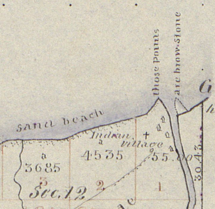
1847 PLSS survey map detailing the mouth of Iron River at what is now Silver City, Michigan along the east entrance to the Porcupine Mountains.
John W. Bell was born in New York City on May 3, 1803, and was consequently eighty-four years and seven months old. He learnt the trade of a cooper, and in this capacity in the year 1835, he came to the Lake superior country for the United States Fur company. He first settled at the mouth of Iron river, in Michigan, about twenty miles west of Ontonagon. Here, at that time, was one of the principal trading and fishing posts of the American Fur company, La Pointe being its headquarters. Remaining at Iron river for a few years, he came to La Pointe about 1840, where he continued to reside till the time of his death.

1845 United States map by John Dower, with the northernmost area of Wisconsin Territory that became La Pointe County.
At the time he came upon this lake its shores were an unbroken wilderness. At the Sault was a United States fort, but from the foot of Lake Superior to the Pacific ocean, no white settlement existed. The American and Northwest Fur companies were lords of this vast empire, and their trading posts and a few mission stations connected with them, held control. A small detachment of United States soldiers formed the distant outposts of Ft. Snelling. The state of Wisconsin had not been organized. No municipal government existed upon this lake. It was many years before Wisconsin was organized.
1845 United States map by J. Calvin Smith, with the original 1845 boundaries of La Pointe County added in red outline.
“beginning at the mouth of Muddy Island river [on the Mississippi River], thence running in a direct line to Yellow Lake, and from thence to Lake Courterille, so to intersect the eastern boundary line at that place, of the county of St Croix, thence to the nearest point on the west fork of Montreal river, thence down said river to Lake Superior.”
Finally the county of La Pointe was formed, embracing all Wisconsin bordering upon the lake and extending to town forty north. “Squire Bell,” as he was always called, became one of the county as well as town officers of the town and county of La Pointe, and for more than thirty years continued to hold office, being at different times chairman of supervisors, register of deeds, justice of the peace, clerk of the circuit court and county judge. This last office he held for many years.
He was a man of genial nature and robust frame. About four years ago, while in Ashland he fell and fractured his thigh, and was never able to walk again. His sufferings from this accident were great and his pleasant face was never seen again in Ashland. He enjoyed the esteem and friendship of his neighbors, so far as is known without exception. He was clear headed and of commanding appearance. His influence among the Indians and the French who for many years were the only inhabitants in the country was very great, and continued to the last. For years his dictum was the last resort for the settlement of the quarrels in this primitive community, and it seems to have been just and satisfactory. He was often called “The King of La Pointe,” and for years no one disputed his supremacy.

Edwin Ellis, M.D.
Dr. Edwin Ellis, of this city, said in speaking of the dead old pioneer:
“Thus one by one the early settlers are passing away, and ere long an entirely new generation will occupy the old haunts. He will rest upon the beautiful isle overlooking Chequamegon bay, where the landscape has been familiar to him for more than a generation. We a little longer linger on the shores of time, waiting the summons to cross the river. While we consign the body of an old friend to the earth we will in all heartfelt sorrow say: ‘Requiescat in Pace.'”
Superior Times
Saturday, January 7, 1888, Page 2
The Lake Superior Monarch
Judge Bell, the ‘king of the Apostle islands,’ who died the other day on Madeline Island at the age of eighty-three, was a conspicuous character in the early history of the Lake Superior region. He was the “king” of the county known as La Pointe, which was organized in 1846 by himself. The county was as large as many states of the Union, its borders including nearly all of Wisconsin north of the Chippewa river, the Apostle islands, and to an almost endless distance west. The white population consisted of a handful of French voyagers, traders and trappers, most of whom made their rendezvous at La Pointe. The country was hardly known by the state, and Bell’s realm was practically a little monarchy. He “bossed” everything and everybody, but in such a way that every Indian and every white was his friend and follower. Judge Bell rarely left the island except to make occasional pilgrimages through the settlements. During his eventful life he held every office in the county, and of late years had served as county judge. He was a man of great native ability, and was possessed of a courage that controlled the rough element that surrounded him in the early days when there was no law except his will. He was an honest, fearless, natural-born ruler of men. Through his efforts the poor and needy were cared for. His power departed only when the advanced guard of civilization reached the great inland sea. For many years he had been feeble, and of late had become a charge upon the town. He spent thousands upon the people.
To be continued in Fooled the Austrian Brothers…
1839 Petitions against Payments at La Pointe
October 10, 2025
Collected & edited by Amorin Mello
Previously we featured 1837 Petitions from La Pointe to the President about $100,000 Payments to Chippewa Mixed-Bloods from the 1837 Treaty of Saint Peters, and 1838 more Petitions from La Pointe to the President about relocating the Payments from St. Croix River to Lake Superior. Those earlier Petitions were from Chief Buffalo and dozens of Mixed-Bloods from the Lake Superior Chippewa Bands, setting precedence for La Pointe to host the 1842 Treaty and 1854 Treaty in later decades.
Today’s post features 1839 Petitions against Payments at La Pointe. These petitioners appear to be looking to get a competitive edge against the American Fur Company monopoly at La Pointe, by moving the payments south across the Great Divide into the Mississippi River Basin.
For more information about the $100,000 Payments at La Pointe in 1839, we strongly recommend Theresa M. Schenck’s excellent book All Our Relations: Chippewa Mixed-Bloods and the Treaty of 1837.
Letters Received by the Office of Indian Affairs:
La Pointe Agency 1831-1839
National Archives Identifier: 164009310

April 9, 1839
from Joseph Rolette at Prairie du Chien
to the Superintendent of Indian Affairs
Received April 27, 1839
Prairie du Chiene 9th April 1839
T.H. Crawford Esq’r
Commissioner of Ind’n affairs
Washington
You must excuse the liberty I take in addressing you once more – presuming you are not well acquainted yet with this Country, I am requested by the Chippewaw half Breeds that remain in this Country, that it is with regret they have heard that the payment allowed to them in the treaty of the 29th July 1837 is to be made on Lake Superior. They have to State, that it will be impossible for them to reach that place as the American Fur Co. are the only Co. who have vessels on Lake Superior & Notwithstanding they could procure on Passage Gratis on the Lake.
This distance between Sault Ste Mary, and the Mississippi is great and expensive. They also represent that the half Breeds born on Lake Superior are not entitled to any Share of the money allowed.
Whereas if the Payment was made at the Falls of St. Croix, there would be Competition amongst traders, whereas in Lake Superior they can be done none. They humbly beseech that you will have Mercy on them and not allow them to be deprived by intrigue of the Sum due them. So Justly to go in other hands but the real owners.
Respectfully
your most obd’t Serv’t
Joseph Rolette
on behalf of the Chippewaw
Half Breeds of
Prairie du Chiens

June 21, 1839
from the Indian Agent at Saint Peters
via the Governor of Wisconsin Territory
to the Superintendent of Indian Affairs
Received July 16, 1839
Answered July 24, 1839
Superintendency of Indn Affairs
for the Territory of Wisconsin
Mineral Point June 20, 1839
Sir,

Henry Dodge
Governor of Wisconsin Territory
I have the honor to transmit, enclosed herewith, three letters from Major Taliaferro, Indian Agent at St Peters, dated 10th, 16th, & 17th inst, with two Indian talks of 3rd & 14th, for the information of the Department.
Very respectfully
Yours obedt sevt
Henry Dodge
Supt Ind Agy
T Hartley Crawford Esq
Com. of Indian Affairs
North Western Agency St Peters
Upper Mississippi June 10th 1839
Governor,
Lawrence Taliaferro
Indian Agent at Fort Snelling
I deem it to be most adviseable that the enclosed paper, addressed to the Agent, and Commanding Officer on this Station from the Chippewa Chief “Hole in the Day” should be forwarded to you, the Indians addressing us being within your Excellency’s Superintendency. It may be well to add that a similar document proceeding from the Chippewa Chiefs of St Croix was on the 4th inst forwarded for the information of the Office of Indian Affairs at Washington.
The consolidation of the two Chippewa Sub Agencies and located at Lapointe, it is feared may lead to rather unpleasant results. I know the Chippewas well, and may have as much influence with those of the Mississippi particularly as most men, yet were I to say “you are not to have an agent in your Country, and you must go to Lapointe in all time to come for your Annuity, and treaty Stipulations.” I should not expect to hold their confidence for one day.
With high respect Sir
Your mo obt Serv
Law Taliaferro
Indian Agent
at S. Peters
His Excellency
Governor Henry Dodge
Suprt of Indi Affairs
at Mineral Point
For Wisconsin
North Western Agency S. Peters
Upper Mississippi June 16th, 1839
Governor
I have been earnestly selected by a number of the respectable half breed Chippewas resident, and others of the Mississippi, interested in the $100,000 set apart in the treaty of July 29, 1837 of S. Peters, to ask for such information as to their final disposal of this Sum, as may be in your possession.
The claimants referred to have learned through the medium of an unofficial letter from the Hon Lucius Lyon to H. H. Sibley Esqr. of this Post, that the funds in question as well as the Debts of the Chippewas to the traders was to be distributed by him as the Commissioner of the United States at Lapointe on Lake Superior, and for this purpose should reach that place on or about the 10th of July. The individuals Seeking this information are those who were were so greatly instrumental in bungling your labours at the treaty aforesaid to a successful issue in opposition to the combinations formed to defeat the objects of the government.
There remains 56,000$ in specie at this post being the one half of the sum appropriated or applicable to the objects in contemplation, and upon which the authorities here have had as yet no official instructions to transfer some special information would relieve the minds of a miserably poor class of people and who fear the entire loss of their just claims.
With high respect, Sir
your mo obt Sevt
Law Taliaferro
Indn Agent
at S. Peters
His Excellency
Gov Henry Dodge
Suprt of Ind. Affairs
for Wisconsin
North Western Agency S. Peters
Upper Mississippi June 17th 1839
Governor
On the 20th of May past I dispatched Peter Quin Express to the Chippewas of the Upper Mississippi with a letter from Maj D. P. Bushnell agent for this tribe at Lapointe notifying the Indians, and half breeds that they would be paid at Lapointe hereafter, and at an earlier period than the last year. I informed you of the result of his mission on the 10th inst. enclosing at the same time the written sentiments of the principle Chief for his people. I now forward by Express a second communication from the Same Source received late last night. I would make a plain copy, but have not time. So the original is Sent.
In four days there will be a large body of Chippwas here, and they cannot be Stopped. There are now also 880 Sioux from remote Sections of the Country at this Post and of course we may calculate on some difficulty between these old enemies. Your presence is deemed essential, or such instructions as may soothe the Angry feelings of the Chippewas, on account of the direction given to their annuity, & treaty Stipulations.
With high respect Sir
Your mo ob Sevt
Law Taliaferro
Indn Agent
at S Peters
His Excellency
Governor Henry Dodge
Suprt of Indi Affairs
Mineral Point
(NB) The Chippewas are to be understood as to the point of payment indicated to be the St.Croix, and not the S.Peters, as deemed by the written Talks. It never could be admited in the present state of the Tribes to pay the Chippewas at this Post, but they might with safety to all parties be paid at or above the Falls of S.Croix, by an agent who they ought to have or some special person assigned to this duty.
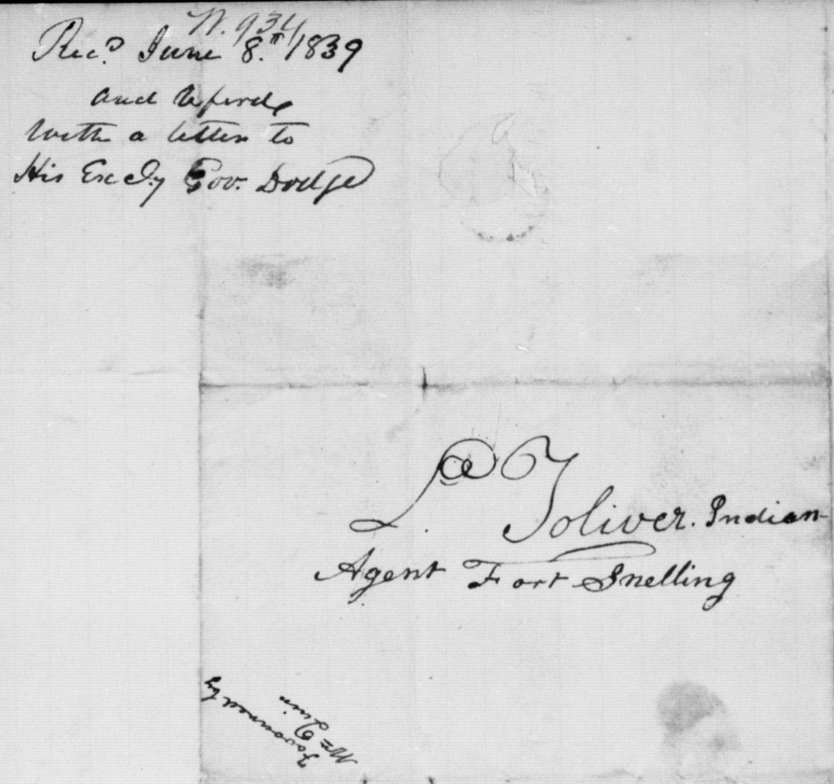
Elk River, June 3rd 1839
Maj Toliver. Maj Plimpton.
My respects to you both, and my hand: I am to let you know that I intend to pay you a visit, with my chiefs as braves, the principle of my warriors are verry anxious to pay you a visit.
The above mentioned men are verry anxious to see Gov. Dodge with whom we made the treaty, that we may have a talk with him. It was with him commissioner of the United-States we made the treaty, and we are verry much disappointed to hear the newes, we hear this day (IE that we must go to Lake Sup. for our pay) which we have this day decided we will not do; that we had rather die first: it is on this account we wish to pay you a visit, and have a talk with Gov. Dodge. You sir, Maj Toliver know verry well our situation, and that the distance is so great for us to go to Lake Sup. for to get our pay &c. or even a gun repaired; that it is inconsistent for such a thing to be required of us; even if we did literally place the matter in the hands of Government. We are all living yet that was present at the treaty when we ceded the land to the Unitedstates, and remember well what was our understanding in the agreement.
We now wish Maj Toliver; to mention to your children that it is a fals report that we had any intention to have more difficulty with the Sioux, as our Missionaries can attest as far as they understand us. We will be at the Fort in seventeen days to pay you a friendly visit as soon as we received the news; we sent expressed to our brethren to meet us at the mouth of Rum Riv. and accompany us to the Fort.
It is my desire that Maj Plimpton would keep fast hold of the money appropriated for my children the half breeds, in this section, and not let it go to Lake Sup. as they are like ourselves and it would cost them a great deal to go there for it.
Pah-ko-ne-ge-zeck or Hole in the Day
Maj Toliver
Maj Plimpton

Elk River June 14 1839
Maj L. Toliphero,
My hand, It is twelve dayes since we have the newes and are all qouiet yet. My father I shall not forget what was promiced us below, I think of what you promiced us when you were buing our lands.
My father this is the thing that you & we me to take care of when you bougt our lands & I remember all that you said to me. My father I am the cheif of all the Indians that sold there land and this is the time when all of your children are coming down to receive their payment where you promiced to pay us.
My father I am the cheif and hold the paper containing the promices that you made us. The Gov. D. promised us that in one year from the date of the treaty that we should receive our first payment and so continue anually.
My father; I have done for manny years what the white men have told me and have done well, and now I must look before we are to know what I have to do.
When I buy anything I pay immediately the Great Spirit knows this Now when we get below we are expecting all that you promiced us Ministers and Black Smiths and cattle.
I say my father that we want our payment at St Peters where you promiced us. I said that I wanted the half breeds to be payed there with us. I told you that when the half breeds were payed that there was some French that should have something ((ie) of the half breed money) because they had lived with us for many years and allways gave us some thing to eat when we went to their houses.
My father all of your children are displeased because you are to pay us in another place and not at St Peters it is to hard and far for us to be payed at Lapointe.
My father I did not know that the payment was to be made at Lapointe until we heard by Mr Quin.
My father it is so far to Lapointe that we should lose all of our children before we could get their and if we should brake our Gun we may throw it in the water for we cannot go there to get it mended, and if we have a [illegible] holding a coppy of the Treaty in his hand
Black Smith we want him here and not at Lapoint.
My father I want that you should tell me who it was told you that we all wanted our payment at Lapoint. All of the Cheifs are alive that hear what you said to us below. You Mr Toliphero hear me ask Gov Do’ for an Agen and to have him located here and he promiced that it should be so. I want that the Agent should be here because our enemies come here sometimes and if he was here perhaps they would not come. My father we are all of us very sorry that we did not ask you to come and be our Agent. I don’t know who made all of the nois about our being payed at Lapoint. I don’t look above where we should all starve for our payment but below where the Treaty was made.
My father give my compliments to all of the officers at the Fort.
Hole in The Day X
Maj L Toliphereo
Judge Bell Incidents: King of the Apostle Islands
January 30, 2025
Collected & edited by Amorin Mello
This post is the first of a series featuring The Ashland News items about La Pointe’s infamous Judge John William Bell, written mainly by his son-in-law George Francis Thomas née Gilbert Fayette Thomas a.k.a G.F.T.
Wednesday, September 30, 1885, page 2.
ON HISTORICAL GROUND.

James Chapman
~ Madeline Island Museum

Judge Joseph McCloud
~ Madeline Island Museum
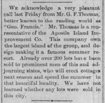
Saturday last, says The Bayfield Press, the editor had the pleasure of visiting Judge John W. Bell at his home at La Pointe, accompanied by Major Wing, James Chapman and Judge Joseph McCloud. The judge, now in his 81st year, still retains much of that indomitable energy that made him for many years a veritable king of the Apostle Islands. Owing, however, to a fractured limb and an irritating ulcer on his foot he is mostly confined to his chair. His recollection of the early history of this country is vivid, while his fund of anecdotes of his early associates is apparently inexhaustible and renders a visit to this remarkable pioneer at once full of pleasure and instruction. The part played by Judge Bell in the early history of this country is one well worthy of preservation and in the hands of competent parties could be made not the least among the many historical sketches of the pioneers of the great northwest. The judge’s present home is a large, roomy house, located in the center of a handsome meadow whose sloping banks are kissed by the waters of the lake he loves so well. Here, surrounded by children and grand-children, cut off from the noise and bustle of the outside world, his sands of life are peacefully passing away.
Leaving La Pointe our little party next visited the site of the Apostle Islands Improvement company’s new summer resort and found it all the most vivid fancy could have painted. Here, also, we met Peter Robedeaux, the oldest surviving voyager of the Hudson Bay Fur Co. Mr. Robedeaux is now in his 89th year, and is as spry as any man not yet turned fifty. He was born near Montreal in 1796, and when only fourteen years of age entered the employ of the Hudson Bay Fur Co., and visited the then far distant waters of the Columbia river, in Washington Territory. He remained in the employ of this company for twenty-five years and then entered the employ of the American Fur company, with headquarters at La Pointe. For fifty years this man has resided on Madeline Island, and the streams tributary to the great lake not visited by him can be numbered by the fingers on one’s hand. His life until the past few years has been one crowded with exciting incidents, many of which would furnish ample material for the ground-work of a novel after the Leather Stocking series style.
Wednesday, June 30, 1886, page 2.
GOLDEN WEDDING.
About thirty of the old settlers of Ashland and Bayfield went over to La Pointe on Saturday to celebrate the golden wedding anniversary of Judge John W. Bell and wife, who were married in the old church at La Pointe June 26th, 1836, fifty years ago. The party took baskets containing their lunch with them, the old couple having no knowledge of the intended visit. After congratulations had been extended the table was spread, and during the meal many reminiscences of olden times were called up.
Judge Bell is in his eighty-third year, and is becoming quite feeble. Mrs. Bell is perhaps ten or twelve years younger. Judge Bell came to La Pointe in 1834, and has lived there constantly ever since. La Pointe used to be the county seat of Ashland county, and prior to the year 1872 Judge Bell performed the duties of every office of the county. In fact he was virtually king of the island.
The visitors took with them some small golden tokens of regard for the aged couple, the coins left with them aggregating between $75 and $100.
Wednesday, July 20, 1887, page 6.
REMINISCENCES OF OLD LA POINTE
(Written for The Ashland News)
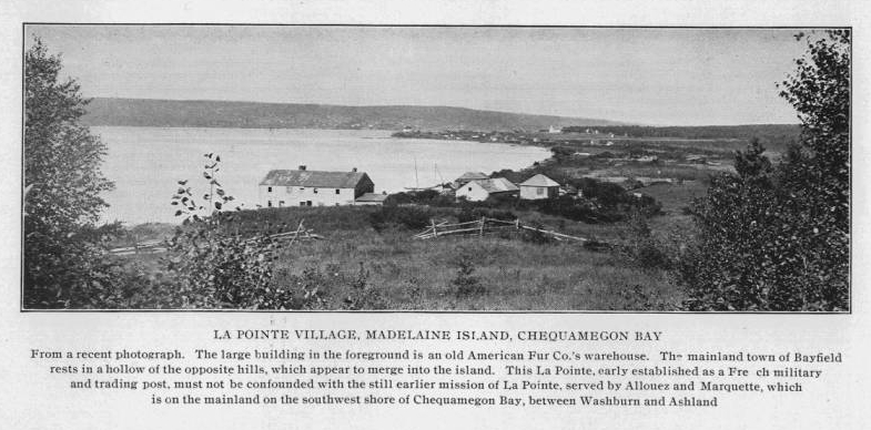
Visitors to this quiet and delapidated old town on Madeline Island, Lake Superior, about whom early history and traditions so much has been published, are usually surprised when told that less than forty years have passed since there flourished at this point a city of about 2,500 people. Now not more than thirty families live upon the entire island. Thirty-five years ago neither Bayfield, Ashland nor Washburn was thought of, and La Pointe was the metropolis of Northern Wisconsin.
Since interesting himself in the island the writer has often been asked: Why, if there were so many inhabitants there as late as forty years ago, are there so few now? In reply a great number of reasons present themselves, chief among which are natural circumstances, but in the writer’s mind the imperfect land titles clouding old La Pointe for the last thirty years have tended materially to hastening its downfall.

Captain John Daniel Angus
~ Madeline Island Museum
Of the historic data of La Pointe, of which the writer has almost an unlimited supply, much that seems romance is actual fact, and the witnesses of occurrences running back over fifty years are still here upon the island and can be depended upon for the truthfulness of their reminiscences. There are no less than five very old men yet living here who have made their homes upon the island for over fifty years. Judge John W. Bell, or “Squire,” as he is familiarly called, has lived here since the year 1835, coming from the “Soo,” on the brig, John Jacob Astor, in company with another old pioneer of the place known as Capt. John Angus. Mr. Bell contracted with the American Fur Co., and Capt. Angus sailed the “Big Sea” over. Mr. Bell is now eighty three years of age, and is crippled from the effects of a fall received while attending court in Ashland, in Jan. 1884. He is a man of iron constitution and might have lived – and may yet for all we know – to become a centenarian. The hardships of pioneer life endured by the old Judge would have killed an ordinary man long ago. He is a cripple and an invalid, but he has never missed a meal of victuals nor does he show any sign of weakening of his wonderful mind. He delights to relate reminiscences of early days, and will talk for hours to those who prove congenial. Once in his career, Mr. Bell had in his employ the famous “Wilson, the Hermit,” whose romantic history is one of the interesting features sought after by tourists when they visit the islands.
~ History of Northern Wisconsin, by the Western Historical Co., 1881.
Once Mr. Bell started an opposition fur company having for his field of operations that portion of Northern Wisconsin and Michigan now included within the limits of the great Gogebic and Penokee iron ranges, and had in his employ several hundred trappers and carriers. Later Mr. Bell became a prominent explorer, joining numerous parties in the search for gold, silver and copper; iron being considered too inferior a metal for the attention of the popular mind in those days.
Almost with his advent on the island Mr. Bell became a leader in the local political field, during his residence of fifty-two years holding almost continually some one of the various offices within the gift the people. He was also employed at various times by the United States government in connection with Indian affairs, he having a great influence with the natives.

Ramsay Crooks
~ Madeline Island Museum
The American Fur Co., with Ramsay Crooks at its head gave life and sustenance to La Pointe a half century ago, and for several years later, but when a private association composed of Borup, Oakes and others purchased the rights and effects of the American Fur Co., trade at La Pointe began to fall away. The halcyon days were over. The wild animals were getting scarce, and the great west was inducing people to stray. The new fur company eventually moved to St. Paul, where even now their descendants can be found.

Julius Austrian
~ Madeline Island Museum
Prior to the final extinction of the fur trade at La Pointe and in the early days of steamboating on the great lakes, the members of the well-known firm of Leopold & Austrian settled here, and soon gathered about them a number of their relatives, forming quite a Jewish colony. They all became more or less interested in real estate, Julius and Joseph Austrian entering from the government at $1.25 per acre all the lands upon which the village was situated, some 500 acres.

Joseph Austrian
~ Jennifer Barber Family
The original patent issued by the government, of which a copy exists in the office of the register of deeds in Ashland, is a literary curiosity, as are also many other title papers issued in early days. Indeed if any one will examine the records and make a correct abstract or title history of old La Pointe, the writer will make such person a present of one of the finest corner lots on the island. Such a thing can not be done simply from the records. A large portion of the original deeds for village lots were simply worthless, but the people in those days never examined into the details, taking every man to be honest, hence errors and wrongs were not found out.
Now the lots are not worth the taxes and interest against them, and the original purchaser will never care whether his title was good or otherwise. The county of Ashland bought almost the whole town site for taxes many years ago and has had an expensive load to carry until the writer at last purchased the tax titles of the village, which includes many of the old buildings. The writer has now shouldered the load, and proposes to preserve the old relics that tourists may continue to visit the island and see a town of “Ye olden times.”
~ The Boscobel Dial
September 29, 1885.
Originally the intention was to form a syndicate to purchase the old town. An association of prominent citizens of Ashland and Bayfield, at one time came very near securing it, and the writer still has hopes of such an association some day controlling the historical spot. The scheme, however, has met with considerable opposition from a few who desire no changes to be made in the administration of affairs on the island. The principal opponent is Julius Austrian, of St. Paul, who still owns one-sixth part of La Pointe, and is expecting to get back another portion of lots, which have been sold for taxes and deeded by the county ever since 1874. He would like no doubt, to make Ashland county stand the taxes on the score of illegality. As a mark of affection for the place, he has lately removed the old warehouse which has stood so many years a prominent landmark in La Pointe’s most beautiful harbor. Tourists from every part of the world who have visited the old town will join in regretting the loss and despise the action.
G. F. T.
To be continued in King No More…
1842 Treaty Speeches at La Pointe in the News
May 15, 2024
Collected by Amorin Mello & edited by Leo Filipczak

Green Bay Republican:
Saturday, November 5, 1842, Page 2.

Robert Stuart was a top official in Astor’s American Fur Company in the upper Great Lakes region. Apparently, it was not a conflict of interest for him to also be U.S. Commissioner for a treaty in which the Fur Company would be a major beneficiary.
A gentleman who has recently returned from a visit to the Lake Superior Indian country, has furnished us with the particulars of a Treaty lately negotiated at La Pointe, during his sojourn at that place, by ROBERT STUART, Esq., Commissioner of Indian Affairs for the district of Michigan, on the part of the United States, and by the Chiefs and Braves of the Chippeway Indian nation on their own behalf and their people. From 3 to 4000 Indians were present, and the scene presented an imposing appearance. The object of the Government was the purchase of the Chippeway country for its valuable minerals, and to adopt a policy which is practised by Great Britain, i.e. of keeping intercourse with these powerful neighbors from year to year by paying them annuities and cultivating their friendship. It is a peculiar trait in the Indian character of being very punctual in regard to the fulfillment of any contract into which they enter, and much dissatisfaction has arisen among the different tribes toward our Government, in consequence of not complying strictly to the obligations on their part to the Indians, in the time of making the payments, for they are not generally paid until after the time stipulated in the treaty, and which has too often proven to be the means of losing their confidence and friendship.
On the 30th of September last, Mr. Stuart opened the Council, standing himself and some of his friends under an awning prepared for the occasion, and the vast assembly of the warlike Chippeways occupying seats which were arranged for their accommodation. A keg of Tobacco was rolled out and opened as a present to the Indians, and was distributed among them; when Mr. Stuart addressed them as follows:-
The Passenger Pigeon (Ectopistes migratorius) was a metaphor for infinite abundance in 1842. In less than 75 years, the species would be extinct. What that means for Stuart’s metaphor is hard to say (Biodiversity Heritage Library).
The chiefs who had been to Washington were the St. Croix chiefs Noodin (pictured below) and Bizhiki. They were brought to the capital as part of a multi-tribal delegation in 1824, which among other things, toured American military facilities.I am very glad to meet and shake hands with so many of my old friends in good health; last winter I visited your Great Father in Washington, and talked with him about you. He knows you are poor and have but little for your women and children, and that your lands are poor. He pities your condition, and has sent me here to see what can be done for you; some of your Bands get money, goods, and provisions by former Treaty, others get none because the Great Council at Washington did not think your lands worth purchasing. By the treaty you made with Gov. Cass, several years ago, you gave to your lands all the minerals; so the minerals belong no longer to you, and the white men are asking him permission to take the minerals from the land. But your Great Father wishes to pay you something for your lands and minerals before he will allow it. He knows you are needy and can be made comfortable with goods, provisions, and tobacco, some Farmers, Carpenters to aid in building your houses, and Blacksmiths to mend your guns, traps, &c., and something for schools to learn your children to read and write, and not grow up in ignorance. I hear you have been unpleased about your Farmers and Blacksmiths. If there is anything wrong I wish you would tell me, and I will write all your complaints to your Great Father, who is ever watchful over your welfare. I fear you do not esteem your teachers who come among you, and the schools which are among you, as you ought. Some of you seem to think you can learn as formerly, but do you not see that the Great Spirit is changing things all around you. Once the whole land was owned by you and other Indian Nations. Now the white men have almost the whole country, and they are as numerous as the Pigeons in the spring. You who have been in Washington know this; but the poor Indians are dying off with the use of whiskey, while others are sent off across the Mississippi to make room for the white men. Not because the Great Spirit loves the white men more than the Indians, but because the white men are wise and send their children to school and attend to instructions, so as to know more than you do. They become wise and rich while you are poor and ignorant, but if you send your children to school they may become wise like the white men; they will also learn to worship the Great Spirit like the whites, and enjoy the prosperity they enjoy. I hope, and he, that you will open your ears and hearts to receive this advice, and you will soon get great light. But said he, I am afraid of you, I see but few of you go to listen to the Missionaries, who are now preaching here every night; they are anxious that you should hear the word of the Great Spirit and learn to be happy and wise, and to have peace among yourselves.
The 1837 Treaty of St. Peters was mostly negotiated by Maajigaabaw or “La Trappe” of Leech Lake and other chiefs from outside the territory ceded by that treaty. The chiefs from the ceded lands were given relatively few opportunities to speak. This created animosity between the Lake Superior and Mississippi Bands.Your Great Father is very sorry to learn that there are divisions among his red children. You cannot be happy in this way. Your Great Father hopes you will live in peace together, and not do wrong to your white neighbors, so that no reports will be made against you, or pay demanded for damages done by you. These things when they occur displease him very much, and I myself am ashamed of such things when I hear them. Your Great Father is determined to put a stop to them, and he looks that the Chiefs and Braves will help him, so that all the wicked may be brought to justice; then you can hold up your heads, and your Great Father will be proud of you. Can I tell him that he can depend upon his Chippeway children acting in this way.
One other thing, your Great Father is grieved that you drink whiskey, for it makes you sick, poor, and miserable, and takes away your senses. He is determined to punish those men who bring whiskey among you, and of this I will talk more at another time.
Stuart would become irritated after the treaty when the Ojibwe argued they did not cede Isle Royale in 1842. This lead to further negotiations and an addendum in 1844. The Grand Portage Band, who lived closest to Isle Royale, was not party to the 1842 negotiations.When I was in New York about three moons ago I found 800 blankets which were due you last year, which by some mismanagement you did not get. Your Great Father was very angry about it, and wished me to bring them to you, and they will be given you at the payment. He is determined to see that you shall have justice done you, and to dismiss all improper agents. He despises all who would do you wrong. Now I propose to buy your lands from Fond du Lac, at the head of Lake Superior, down Lake Superior to Chocolate River near Grand Island, including all the Islands in the limits of the United States, in the Lake, making the boundary on Lake Superior about 250 miles in extent, and extending back into the country on Lake Superior about 100 miles. Mr. Stuart showed the Chiefs the boundary on the map, and said you must not suppose that your Great Father is very anxious to buy your lands, the principal object is the minerals, as the white people will not want to make homes upon them. Until the lands are wanted you will be permitted to live upon them as you now do. They may be wanted hereafter, and in this event your Great Father does not wish to leave you without a home. I propose that the Fond du Lac lands and the Sandy Lake tract (which embrace a tract 150 miles long by 100 miles deep) be left you for a home for all the bands, as only a small part of the Fond du Lac lands are to be included in the present purchase. Think well on the subject and counsel among yourselves, but allow no black birds to disturb you, your Great Father is now willing and can do you great good if you will, but if not you must take the consequences. To-morrow at the fire of the gun you can come to the Council ground and tell me whether the proposal I make in the name of your Great Father is agreeable to you; if so I will do what I can for you, you have known me to be your friend for many years. I would not do you wrong if I could, but desire to assist you if you allow me to do so. If you now refuse it will be long before you have another offer.

October 1st. At the sound of the Cannon the Council met, and when all were ready for business, Shingoop, the head Chief of the Fond du Lac band, with his 2d and 3d Chiefs, came forward and shook hands with the Commissioner and others associated with him, then spoke as follows:
Zhingob (Balsam), also known as Nindibens, signed the 1837, 1842, and 1854 treaties as chief or head chief of Fond du Lac. The Zhingob on earlier treaties is his father. See Ely, ed. Schenck, The Ojibwe Journals of Edmund F. ElyNaagaanab (Foremost Sitter) is likely the 2nd Fond du Lac chief mentioned here.
My friend, we now know the purpose you came for and we don’t want to displease you. I am very glad there are so many Indians here to hear me. I wish to speak of the lands you want to buy of me. I don’t wish to displease the Traders. I don’t wish to displease the half-breeds; so I don’t wish to say at once, right off. I want to know what our Great Father will give us for them, then I will think and tell you what I think. You must not tell a lie, but tell us what our Great Father will give us for our lands. I want to ask you again, my Father. I want to see the writing, and who it is that gave our Great Father permission to take our minerals. I am well satisfied of what you said about Blacksmiths, Carpenters, Schools, Teachers, &c., as to what you said about whiskey, I cannot speak now. I do not know what the other Chiefs will say about it. I want to see the treaty and the name of the Chiefs who signed. The Chief answered that the Indians had been deceived, that they did not so understand it when they signed it.

Mr. Stuart replied that this was all talk for nothing, that the Government had a right to the minerals under former treaty, yet their Great Father wishes now to pay for the minerals and purchase their lands.
The Chief said he was satisfied. All shook hands again and the Chief retired.
The next Chief who came forward was the “Great Buffalo” Chief of the La Pointe band. Had heavy epaulettes on his shoulders and a hat trimmed with tinsel, with a heavy string of bear claws about his neck, and said:-
“Big Buffalo (Chippewa),” 1832-33 by Henry Inman, after J.O. Lewis (Smithsonian).
My father, I don’t speak for myself only, but for my Chiefs. What you said here yesterday when you called us your children, is what I speak about. I shall not say what the other Chief has said, that you have heard already.

He then made some remarks about the Missionaries who were laboring in their country and thought as yet, little had been done. About the Carpenters, he said, that he could not tell how it would work, as he had not tried it yet.
We have not decided yet about the Farmers, but we are pleased at your proposal about Blacksmiths. Can it be supposed that we can complete our deliberations in one night. We will think on the subject and decide as soon as we can.
The great Antonaugen Chief came next, observing the usual ceremony of shaking hands, and surrounded by his inferior Chiefs, said:-
The great Ontonagon Chief is almost certainly Okandikan (Buoy), depicted here in a reproduction of an 1848 pictograph carried to Washington and reproduced by Seth Eastman. Okandikan is depicted as his totem symbol, the eagle (largest, with wing extended in the center of the image).
My father and all the people listen and I call upon my Great Father in Heaven to bear witness to the rectitude of my intentions. It is now five years since we have listened to the Missionaries, yet I feel that we are but children as to our abilities. I will speak about the lands of our band, and wish to say what is just and honorable in relation to the subject. You said we are your children. We feel that we are still, most of us, in darkness, not able fully to comprehend all things on account of our ignorance. What you said about our becoming enlightened I am much pleased; you have thrown light on the subject into my mind, and I have found much delight and pleasure thereby. We now understand your proposition from our Great Father the President, and will now wait to hear what our Great Father will give us for our lands, then we will answer. This is for the Antannogens and Ance bands.

Mr. Stuart now said, that he came to treat with the whole Chippeway Nation and look upon them all as one Nation, and said
I am much pleased with those who have spoken; they are very fine orators; the only difficulty is, they do not seem to know whether they will sell their lands. If they have not made up their minds, we will put off the Council.
Lac du Flambeau Chief, “the Great Crow,” came forward with the strict Indian formalities but had but little to say, as he did not come expecting to have any part in the treaty, but wished to receive his payment and go home.
The 2d Chief of this band wished to speak. He was painted red with black spots on each cheek to set off his beauty, his forehead was painted blue, and when he came to speak, he said:-
What the last Chief has said is all I have to say. We will wait to hear what your proposals are and will answer at a proper time.
Next came forward “Noden,” or the “Great Wind,” Chief of the Mill Lac band, and said:-

Noodin (Wind) is mentioned here as representing the Mille Lacs Band, though his village was usually on Snake River of the St. Croix.
I have talked with my Great Father in Washington. It was a pity that I did not speak at the St. Peters treaty. My father, you said you had come to do justice. We do not wish to do injustice to our relations, the half-breeds, who are also our friends. I have a family and am in a hurry to get home, if my canoes get destroyed I shall have to go on foot. My father, I am hurry, I came for my payment. We have left our wives and children and they are impatient to have us return. We come a great distance and wish to do our business as soon as we can. I hope you will be as upright as our former agent. I am sorry not to see him seated with you. I fear it will not go as well as it would. I am hurry.
Mr Stuart now said that he considered them all one nation, and he wished to know whether they wished to sell their lands; until they gave this answer he could do nothing, and as it regards any thing further he could say nothing, and said they might now go away until Monday, at the firing of the Cannon they might come and tell him whether they would sell their country to their Great Father.
We intend giving the remainder of the proceedings of the treaty in our next.
Green Bay Republican:
SATURDAY, NOVEMBER 12, 1842, Page 2.
(Treaty with the Chippeways Concluded.)
Monday morning three guns were fired as a signal to open the Treaty. When all things were in readiness, Mr. Stuart said:
I am glad you have now had time for reflection, and I hope you are now ready like a band of brothers to answer the question which I have proposed. I want to see the Nation of one heart and of one mind.
Shingoop, Chief of the Fond du Lac band, came forward with full Indian ceremony, supported on each side by the inferior Chiefs. He addressed the Chippeway nation first, which was not fully interpreted; then he turned to the Commissioner and said:
in this Treaty which we are about to make, it is in my heart to say that I want our friends the traders, who have us in charge provided for. We want to provide also for our friends the half-breeds – we wish to state these preliminaries. Now we will talk of what you will give us for our country. There is a kind of justice to be done towards the traders and half-breeds. If you will do justice to us, we are ready to-morrow to sign the treaty and give up our lands. The 2d Chief of the band remarked, that he considered it the understanding that the half-breeds and traders were to be provided for.
The Great Buffalo, of La Pointe band, and his associate Chiefs came next, and the Buffalo said:
My Father, I want you to listen to what I say. You have heard what one Chief has said. I wish to say I am hurry on account of keeping so many men and women here away from their homes in this late season of the year, so I will say my answer is in the affirmative of your request; this is the mind of my Chiefs and braves and young men. I believe you are a correct man and have a heart to do justice, as you are sent here by our Great Father, the President. Father, our traders are so related to us that we cannot pass a winter without them. I want justice to be done them. I want you and our Great Father to assist us in doing them justice, likewise our half-breed children – the children of our daughters we wish provided for. It seems to me I can see your heart, and you are inclined to do so. We now come to the point for ourselves. We wish to know what you will give us for our country. Tell us, then we will advise with our friends. A part of the Antaunogens band are with me, the other part are turned Christians and gone with the Methodist band, (meaning the Ance band at Kewawanon) these are agreed in what I say.
The Bird, Chief of the Ance band, called Penasha, came forward in the usual form and said:
My Father, now listen to what I have to say. I agree with those who have spoken as far as our lands are concerned. What they say about our traders and half-breeds, I say the same. I speak for my band, they make use of my tongue to say what they would say and to express their minds. My Father, we listen to what you will offer for our country, then we will say what we have to say. We are ready to sell our country if your proposals are agreeable. All shook hands – equal dignity was maintained on each side – there was no inclination of the head or removing the hat – the Chiefs took their seats.
The White Crow next appeared to speak to the Great Father, and said:-
White Crow is apparently unaware that in the eyes of the United States, his lands, (Lac du Flambeau) were already sold five years earlier at St. Peters. Clearly, the notion of buying and selling land was not understood by him in the same way it was understood by Stuart.
Listen to what I say. I speak to the Great Father, to the Chiefs, Traders, and Half-breeds. You told us there was no deceit in what you say. You may think I am troublesome, but the way the treaty was made at St. Peters, we think was wrong. We want nothing of the kind again. We think you are a just man. You have listened to those Chiefs who live on Lake Superior. What I say is for another portion of country. It appears you are not anxious to buy the lands where I live, but you prefer the mineral country. I speak for the half-breeds, that they may be provided for: they have eaten out of the same dish with us: they are the children of our sisters and daughters. You may think there is something wrong in what I say. As to the traders, I am not the same mind with some. The old traders many years ago, charged us high and ought to pay us back, instead of bringing us in debt. I do not wish to provide for them; but of late years they have had looses and I wish those late debts to be paid. We do not consider that we sell our lands by saying we will sell them, so we consent to sell if your proposals are agreeable. We will listen and hear what they are.
Several others of the Chiefs spoke well on the subject, but the substance of all is contained in the above.
Hole-in-the-day, who is at once an orator and warrior, came forward; he had an Arkansas tooth pick in his hand which would weigh one or two pounds, and is evidently the greatest and most intelligent man in the nation, as fine a form of body, head and face, as perhaps could be found in any country.
Father, said he, I arise to speak. I have listened with pleasure to your proposal. I have come to tie the knot. I have come to finish this part of the treaty, and consent to sell our country if the offers of the President please us. Then addressing the Chiefs of the several bands he said, the knot is now tied, and so far the treaty is complete, not to be changed.

Zhaagobe (“Little” Six) signed as first chief from Snake River, and he is almost certainly the “Big Six” mentioned here. Several Ojibwe and Dakota chiefs from that region used that name (sometimes rendered in Dakota as Shakopee).
Big Six now addressed the whole Nation in a stream of eloquence which called down thunders of applause; he stands next to Hole-in-the-day in consequence and influence in the nation. His motions were graceful, his enunciation rather rapid for a fine speaker. He evidently possesses a good mind, though in person and form he is quite inferior to Hole-in-the-day. His speech was not interpreted, but was said to be in favor of selling the Chippeway country if the offer of the Government should meet their expectations, and that he took a most enlightened view of the happiness which the nation would enjoy if they would live in peace together and attend to good counsel.
Mr. Stuart now said,
I am very happy that the Chippewa nation are all of one mind. It is my great desire that they should continue to for it is the only way for them to be happy and wise. I was afraid our “White Crow” was going to fly away, but am happy to see him come back to the flock, so that you are all now like one man. Nothing can give me greater pleasure than to do all for you I can, as far as my instructions from your Great Father will allow me. I am sorry you had any cause to complain of the treaty at St. Peters. I don’t believe the Commissioner intended to do you wrong, but perhaps he did not know your wants and circumstances so as to suit. But in making this treaty we will try to reconcile all differences and make all right. I will now proceed to offer you all I can give you for your country at once. You must not expect me to alter it, I think you will be pleased with the offer. If some small things do not suit you, you can pass them over. The proposal I now make is better than the Government has given any other nation of Indians for their lands, when their situations are considered. Almost double the amount paid to the Mackinaw Indians for their good lands. I offer more than I at first intended as I find there are so many of you, and because I see you are so friendly to our Government, and on account of your kind feelings for the traders and half-breeds, and because you wish to comply with the wishes of your Great Father, and because I wish to unite you all together. At first I thought of making your annuities for only twenty years but I will make them twenty-five years. For twenty-five years I will offer you the following and some items for one year only.
$12,500 in specie each year for 25 years, $312,500
10,500 in goods ” ” ” ” ” 262,500
2,000 in provisions and tobacco, do. 50,000$625,000
This amount will be connected with the annuity paid to a part of the bands on the St. Peters treaty, and the whole amount of both treaties will be equally distributed to all the bands so as to make but one payment of the whole, so that you will be but one nation, like one happy family, and I hope there will be no bad heart to wish it otherwise. This is in a manner what you are to get for your lands, but your Great Father and the great Council at Washington are still willing to do more for you as I will now name, which you will consider as a kind of present to you, viz:
2 Blacksmiths, 25 years, $2000, $50,000
2 Farmers, ” ” 1200, 30,000
2 Carpenters, ” ” 1200, 30,000
For Schools, ” ” 2000, 50,000
For Plows, Glass, Nails, &c. for one year only, 5000
For Credits for one year only, 75,000
For Half-breeds ” ” ” 15,000$255,000
Total $880,000
With regards to the claims. I will not allow any claim previous to 1822; none which I deem unjust or improper. I will endeavor to do you justice, and if the $75,000 is not all required to pay your honest debts, the balance shall be paid to you; and if but a part of your debts are paid your Great Father requires a receipt in full, and I hope you will not get any more credits hereafter. I hope you have wisdom enough to see that this is a good offer. The white people do not want to settle on the lands now and perhaps never will, so you will enjoy your lands and annuities at the same time. My proposal is now before you.
The Fond du Lac Chief said, we will come to-morrow and give our answer.
October 4th, Mr. Stuart opened the Council.
Clement Hudon Beaulieu, was about thirty at this time and working his way up through the ranks of the American Fur Company at the beginning of what would be a long and lucrative career as an Ojibwe trader. His influence would have been very useful to Stuart as he was a close relative of Chief Gichi-Waabizheshi. He may have also been related to the Lac du Flambeau chiefs–though probably not a grandson of White Crow as some online sources suggest.
We have now met said he, under a clear sun, and I hope all darkness will be driven away. i hope there is not a half-breed whose heart is bad enough to prevent the treaty, no half-breed would prevent he treaty unless he is either bad at heart or a fool. But some people are so greedy that they are never satisfied. I am happy to see that there is one half-breed (meaning Mr. Clermont Bolio) who has heart enough to advise what is good; it is because he has a good heart, and is willing to work for his living and not sponge it out of the Indians.

We now heard the yells and war whoops of about one hundred warriors, ornamented and painted in a most fantastic manner, jumping and dancing, attended with the wild music usual in war excursions. They came on to the Council ground and arrested for a time the proceedings. These braves were opposed to the treaty, and had now come fully determined to stop the treaty and prevent the Chiefs from signing it. They were armed with spears, knives, bows and arrows, and had a feather flag flying over ten feet long. When they were brought to silence, Mr. Stuart addressed them appropriately and they soon became quiet, so that the business of the treaty proceeded. Several Chiefs spoke by way of protecting themselves from injustice, and then all set down and listened to the treaty, and Mr. Stuart said he hoped they would understand it so as to have no complaints to make afterwards.
The provisions of the treaty are the same as made in the proposals as to the amount and the manner of payment. The Indians are to live on the lands until they are wanted by the Government. They reserve a tract called the Fond du Lac and Sandy Lake country, and the lands purchased are those already named in the proposals. The payment on this treaty and that of the St. Peters treaty are to be united, and equal payments made to all the bands and families included in both treaties. This was done to unite the nation together. All will receive payments alike. The treaty was to be binding when signed by the President and the great Council at Washington. All the Chiefs signed the treaty, the name of Hole-in-the-day standing at the head of the list, and it is said to be the greatest price paid for Indian lands by the United States, their situation considered, though the minerals are said to be very valuable.
The Commissioner is said to have conducted the treaty in a very just, impartial and honorable manner, and the Indians expressed the kindest feelings towards him, and the greatest respect for all associated with him in negotiating the treaty and the best feelings towards their Agent now about leaving the country, and for the Agents of the American Fur Company and for the traders. The most of them expressed the warmest kind of feelings toward the Missionaries, who had come to their country to instruct them out of the word of the Great Spirit. The weather was very pleasant, and the scene presented was very interesting.
American Fur Company: 1834 Reinvention of La Pointe
October 4, 2023
Collected & edited by Amorin Mello
The below image from the Wisconsin Historical Society is a storymap showing La Pointe in 1834 as abstract squiggles on an oversized Madeline Island surrounded by random other Apostle Islands, Bayfield Peninsula, Houghton Point, Chequamegon Bay, Long Island, Bad River, Saxon Harbor, and Montreal River.
“Map of La Pointe”
“L M Warren”
“~ 1834 ~”
Wisconsin Historical Society
citing an original map at the New York Historical Society
My original (ongoing) goal for publishing this post is to find an image of the original 1834 map by Lyman Marcus Warren at the New York Historical Society to explore what all of his squiggles at La Pointe represented in 1834. Instead of immediately achieving my original goal, this post has become the first of a series exploring letters in the American Fur Company Papers by/to/about Warren at La Pointe.
New York Historical Society
American Fur Company Papers: 1831-1849
America’s First Business Monopoly
#16,582

Map of Lapointe
by L M Warren
~ 1834 ~
New York Historical Society
scanned as Gale Document Number GALE|SC5110110218
#36
Ramsay Crooks
~ Madeline Island Museum
Lapointe Lake Superior
September 20th ’34
Ramsey Crooks Esqr
Dear Sir
Starting in 1816, the American Fur Company (AFC) operated a trading post by the “Old Fort” of La Pointe near older trading posts built by the French in 1693 and the British in 1793.
In 1834, John Jacob Astor sold his legendary AFC to Ramsay Crooks and other trading partners, who in turn decided to relocate the AFC’s base of operations at Mackinac Island to Madeline Island, where our cartographer Lyman Marcus Warren was employed as the AFC’s trader at La Pointe.
Instead of improving any of the older trading posts on Madeline Island, Warren decided to move La Pointe to the “New Fort” of 1834 to build new infrastructure for growing business demands.

GLO PLSS 1852 survey detail of the “Am Fur Co Old Works” near Old Fort.
on My Way In as Mr Warren was was detained So Long at Mackinac I did not Wait for him at this Place as time was of So Much Consequence to me to Get my People Into the County that I Proceeded Immediately to Fond Du Lac with the Intention with the Intention of Returning to this Place When I Had Sent the Outfit off but When I Got There I Had News from the Interior Which Required me to Go In and Settle the Business there; the [appearance?] In the Interior for [????] is tolerable. Good Provision there is [none?] Whatever I [have?] Seen the [Country?] [So?] Destitute. The Indians at [Fort?] [?????] Disposed to give me Some trouble when they found they have to Get no Debts and buy their amunition and tobacco and not Get it For Nothing as usual but at Length quieted down [?????] and have all gone off to their Haunts as usual.
I Received your Instructions contained in your Circular and will be very Particular In Following them. The outfits were all off when I Received them but the men’s acts and the Invoices of the Goods Had all been Settled according to your Wishes and Every Care Will be taken not to allow the men to get In Debt the Clerks Have Strict orders on the Subject and it is made known to them that they will be Held for any of the Debts the men may Incur.
I Enclose to you the Bonds Signed and all the Funds we Received from Mr Johnston Excepting those Which Had been given to the Clerks and I could not Get them Back In time to Send them on at Present.
Mr Warren And myself Have Committed on What is to be done at this Place and I am certain all that Can be done Will be done by him. I leave here tomorrow For the Interior of Fond Du Lac Where I must be as Soon as possible.
I have written to Mr Schoolcraft as he Inquested me. Mr Brewster’s men would not Give up their [??????] and [???] [????] is [??] [?????] [????] [????] [to?] [???????] [?????] [to?] [persuade?] [more?] People for Keeping [his?] [property?] [Back?] [and] [then?] [???] by some [???] ought to be sent out of the Country [??] they are [under?] [the?] [???] [?] and [Have?] [no?] [Right?] to be [????] [????] they are trouble [????] [???] [their?] [tongues?].

GLO PLSS 1852 survey detail of the AFC’s new “La Point” (New Fort) and the ABCFM’s “Mission” (Middleport).
The Site Selected Here For the Buildings by Mr Warren is the Best there is the Harbour is good and I believe the work will go on well.
as For the Fishing we Will make Every Inquiry on the Subject and I Have no Doubt on My Mind of Fairly present that it will be more valuable than the Fur trade.
In the Month of January I will Write you Every particular How our affairs stand from St Peters. Bailly Still Continues to Give our Indians Credits and they Bring Liquor from that Place which they Say they Get from Him.
Please let Me know as Early as possible with Regard to the Price of Furs as it will Help me In the trade. the Clerks all appear anxious to do their Duty this year as the wind is now Falling and I am In Haste I Will Write you Every particular of our Business In January.
Wishing that God may Long Prosper you and your family.
In health and happiness.
I remain most truly,
and respectfully
yours $$
William A. Aitken
#42
Lake Superior
LaPointe Oct 16 1834
Ramsey Crooks Esqr
Agent American Fur Co
Honoured Sir
Your letter dated Mackinac Sept [??] reached me by Mr Chapman’s boat today.-
I will endeavour to answer it in such a manner as will give you my full and unreserved opinion on the different subjects mentioned in it.
I feel sorry to see friend Holiday health so poor, and am glad that you have provided him a comfortable place at the Sault. As you remark it is a fortunate circumstance that we have no opposition this year or we would certainly have made a poor resistance. I can see no way on which matters would be better arranged under existing circumstances than the way in which you have arranged it. If Chaboillez, and George will act in unison and according to your instructions, they will do well, but I am somewhat affeared, that this will not be the case, as I think George might perhaps from jealously refuse to obey Chaboillez or give him the proper help. Our building business prevents me from going there myself. I suppose you have now received my letter of last Sept, in which I mentioned that I had kept the Doctor here. I shall send him in a few days to see how matters comes on at the Ance. The Davenports are wanted at present in FDLac should it be necessary to make any alteration. I shall leave the Doctor at the Ance.

Undated photograph of the ABCFM Presbyterian Mission Church at it’s original 1830s location along the shoreline of Sandy Bay.
~ Madeline Island Museum

Reverend Sherman Hall
~ Madeline Island Museum
In addition to the AFC’s new La Pointe, Warren was also committed to the establishment of a mission for the American Board of Commissioners for Foreign Missions (ABCFM) as a condition of his 1827 Deed for Old La Pointe from his Chippewa wife’s parents; Madeline & Michel Cadotte.
Starting in 1830, the ABCFM built a Mission at La Pointe’s Middleport (second French fort of 1718), where they were soon joined by a new Catholic Mission in 1835.
Madeline Island was still unceded territory until the 1842 Treaty of La Pointe. The AFC and ABCFM had obtained tribal permissions to build here via Warren’s deed, while the Catholics were apparently grandfathered in through French bloodlines from earlier centuries.
I think we will want about 2 Coopers but as you suggest I if they may be got cheaper than the [????] [????]. The Goods Mr Hall has got is for his own use that is to say to pay his men [??]. The [??] [??????] [has?] to pay for a piece of land they bot from an Indian woman at Leech Lake. As far as my information goes the Missionaries have never yet interfered with our trade. Mr Hall’s intention is to have his establishment as much disconnected with regular business as he possibly can and he gets his supplies from us.
[We?] [have?] received the boxes [Angus?] [??] [???]. [You?] mention also a box, but I have not yet received it. Possible it is at the Ance.
The report about Dubay has no doubt been exaggerated. When with me at the Ance he mentioned to me that Mr Aitkin told him he had better tell the Indians not to kill their beaver entirely off and thereby ruin their country. The idea struck me as a good one and as far as I recollect I told him, it would perhaps be good to tell them so. I have not yet heard from any one, that he has tried to prevent the Indians from paying their old Debts and I should not be astonished to fend the whole is one of those falsehoods which Indians are want to use to free themselves from paying old Debts. I consider Dubay a pretty active man, but the last years extravagancies have made it necessary to have an eye upon him to prevent him from squandering.

“The Doctor” Charles William Wulff Borup, M.D.
~ Madeline Island Museum
My health had been somewhat impaired by my voyage from the Sault to this place. Instead of going to Lac Du Flambeau myself as I intended I sent the Doctor. He has just now returned and tells me that Dubay gets along pretty well, though there were some small difficulties which toke place, but which the Dr settled. The prospect are very discouraging, particularly on a/c of provisions. We have plenty opposition and all of them with liquor in great abundance. It is provoking to see ourselves restricted by the laws from taking in liquor while our opponents deal in it as largely as ever. The traders names are as far as could be ascertained Francois Charette and [Chapy?]. The liquor was at Lac du Flambeau while the Doctor was there. I have furnished Dubay with means to procure provisions, as there is actually not 1 Sack of Corn or Rice to be got.
The same is the case on Lac Courtoreilie and Folleavoigne no provisions and a Mr Demarais on the Chippeway River gives liquor to the Indians.
You want my ideas upon the fishing business. If reliance can be put in Mr Aitkin’s assertions we will at least want the quantity of Net thread mentioned in our order. Besides this we will want for our fishing business 200 Barrels Flour, [??] Barrels Pork, 10 Kegs Butter, 1000 Bushels Corn, [??] Barrels Lard, 10 or 11 Barrels Tallow.

Undated photograph of the ABCFM mission house built in 1832.
~ Madeline Island Museum
Besides this we want over and above the years supply an extra supply for our summer Establishments. say about 80 Barrels Flour, 30 Barrels Pork, 1500 # Butter, 400 Bushels Corn, 5 Barrels Lard, 5 Barrels Tallow. This will is partly to sell. be sold.
Mr Roussain will be as good as any if not better in my opinion for our business than Holiday. Ambrose Davenport might take the charge of the Ance but Roussain will be more able on account of his knowledge in fishing. I would recommend to take him as a partner. say take Holidays share if he could not be got for less.
I have not done much yet toward building. The greatest part of my men have been in the exterior to assist our people to get in. But they have now all arrived. We have got about 4 acres of land cleared, a wintering house put up and a considerable quantity of boards sawed. Mr Aitkin did not supply me with two Carpenters as he promised at Mackinac. I will try to get along as well as I can without them. I engaged Jos Dufault and Mr Aitkin brot me one of Abbott’s men, who he engaged. But I will still be under the necessity of hiring Mr Campbell of the mission to make our windows sashes and to superintend The framing of the buildings. Mr Aitkins have done us considerable damage by not fulfilling his promise in this respect. I told you in Mackinac that Mr Aitkin was far from being exact in business. Your letter to him I will forward by the first opportunity. I think it will have a good effect and you do right in being thus plain in stating your views. His contract deserves censure, and I will hope that your plain dealing with him will not be lost upon him. Shall I beg you to be as faithfull to me by giving me the earliest information whenever you might disapprove of any transaction of mine.
Photograph of La Pointe from Mission Hill circa 1902.
~ Wisconsin Historical Collections, Volume XVI, page 80.
I have received a supply of provisions from Mr Chapmann which will enable me to get through this season. The [?] [of?] [???] [next?], the time you have set for the arrival of the Schooner, will be sufficient, early for our business. The Glass and other materials for finishing of the buildings would be required to be sent up in the first trip but if [we?] [are?] [??] better to have them earlier. If these articles could be sent to the Sault early in the Spring a boat load might be formed of [Some?] and Provisions and sent to the Ance. From there men could be spared at that season of the year to bring the load to this place. In that way there would be no heavy expense incurred and I would be able to have the buildings in greater forwardness.
If the plan should meet your approbation please let me know by the winter express. While Mr Aitkin was here we planned out our buildings. The House will be 86 feet by 26 feet in the clear, the two stores will be put up agreeable to your Draft. We do not consider them to large.
I am afraid I shall not be able to build a wharf in season, but shall do my best to accomplish all that can be done with the means I have.

Undated photograph of Captain John Daniel Angus’ boat at the ABCFM mission dock.
~ Madeline Island Museum
I would wish to call your attention towards a few of the articles in our trade. I do not know how you have been accustomed to buy the Powder whether by the Keg or pound. If a keg is estimated at 50#, there is a great deception for some of our kegs do not contain more than 37 or 40 #s.
Our Guns are very bad particularly the barrels. They splint in the inside after been fired once or twice.
Our Holland twine is better this year than it has been for Years. One dz makes about 20 fathoms, more than last year. But it would be better if it was bleached. The NW Company and old Mr Ermantinger’s Net Thread was always bleached. It nits better and does not twist up when put into the water. Our maitre [??] [???] are some years five strand. Those are too large we have to untwist them and take 2 strands out. Our maitre this year are three strand they are rather coarse but will answer. They are not durable nor will they last as long as the nets of course they have to be [renewed?]. The best maitres are those we make of Sturgeon twine. We [?????] the twine and twist it a little. They last twice as long as our imported maitres. The great object to be gained is to have the maitres as small as possible if they be strong enough. Three coarse strands of twisted together is bulky and soon nits.
Our coarse Shoes are not worth bringing into the country. Strong sewed shoes would cost a little more but they would last longer. The [Booties?] and fine Shoes are not much better.
Our Teakettles used to have round bottoms. This year they are flat. They Indians always prefer the round bottom.
In regard to the observations you have made concerning the Doctor’s deviating from the instructions I gave him on leaving Mackinac, I must in justice to him say that I am now fully convinced in my own mind that he misunderstood me entirely, merely by an expression of mine which was intended by me in regard to his voyage from Mackinac to the Sault but by him was mistaken for the route through Lake Superior. The circumstances has hurt his feelings much and as he at all times does his best for the Interest of the Outfit I ought to have mentioned in my last letter, but it did not strike my mind at that time.

Detail from Carte des lacs du Canada by Jacques Nicolas Bellin in 1744.
When Mr Aitkin was here he mentioned to me some information he had obtained from somebody in Fond du Lac who had been in the NW Co service relating to a remarkable good white fish fishery on the “Milleau” or “Millons” Islands (do not know exactly the proper name). They lay right opposite to Point Quiwinau. a vessel which passes between the island and the point can see both. Among Mr Chapmann’s crew here there is an old man who tells me that he knew the place well, he says the island is large, say 50 or 60 miles. The Indian used to make their hunts there on account of the great quantity of Beaver and Reindeer. It is he says where the NWest Co used to make their fishing for Fort William. There is an excellent harbour for the vessel it is there where the largest white fish are caught in Lake Superior. Furthermore the old man says the island is nearer the American shore than the English. Some information might be obtained from Capt. McCargo. If it proves that we can occupy the grounds I have the most sanguine hopes that we shall succeed in the fisheries upon a large scale.
I hope you will gather all the information you can on the subject. Particular where the line runs. If it belongs to the Americans we must make a permanent post on the Island next year under the charge of an active person to conduct the fisheries upon a large scale.
Jh Chevallier one of the men I got in Mackinac is a useless man, he has always been sick since he left Sault. Mr Aitkin advised me to send him back in Chapman’s Boat. I have therefore send him out to the care of Mr Franchere.
By the Winter Express I will to give you all the informations that I may be able to give. I will close by wishing you great health and prosperity. Please present my Respects to Mr Clapp.
I remain Dear Sir.
Very Respectfully Yours
Most Obedient Servant
Lyman M. Warren
To be Continued in 1835…
By Leo
In April, the Supreme Court heard arguments in the case Department of Commerce v. New York and could render a decision any day on whether or not the 2020 federal census should include a question asking about citizenship status. In January, a Federal District Court in New York ruled that commerce secretary, Wilbur Ross, violated the law by pushing for that question.
Those in agreement with the District ruling suggest that the Trump administration wants to add the question as a way of discouraging immigrants from participating in the census, thereby diminishing the political power of immigrant communities. This, they say, would violate the Constitution on the grounds that the census must be an “actual enumeration” of all persons within the United States, not only citizens.
Proponents of the citizenship question counter that citizenship status is a perfectly natural question to ask in the census, that any government would want to know how many citizens it has, and that several past iterations of the 10-year count have included similar questions.
It remains to be seen how the Supreme Court will rule, but chances are it will not be the last time an issue of race, identity, or citizenship pops up in the politics of the census. From its creation by the Constitution as a way to apportion seats in congress according to populations of the states, the count has always begged tricky questions that essentially boil down to:
Who is a real American? Who isn’t? Who is a citizen? Who is three-fifths of a human being? Who might not be human at all? What does it mean to be White? To be Colored? To be civilized? How do you classify the myriad of human backgrounds, cultures and stories into finite, discrete “races?”
The Civil War and Fourteenth Amendment helped shed light on some of these questions, but it would be a mistake to think that they belong to the past. The NPR podcast Codeswitch has done an excellent series on census, and this episode from last August gives a broad overview of the history.
Here at Chequamegon History, though, we aren’t in the business broad overviews. We are going to drill down right into the data. We’ll comb through the 1850 federal census for La Pointe County and compare it with the 1860 data for La Pointe and Ashland Counties. Just for fun, we’ll compare both with the 1855 Wisconsin State Census for La Pointe County, then double back to the 1840 federal census for western St. Croix County. Ultimately, the hope is to help reveal how the population of the Chequamegon region viewed itself, and ultimately how that differed from mainstream America’s view. With luck, that will give us a framework for more stories like Amorin’s recent post on the killing of Louis Gurnoe.
Background
 Judge Daniel Harris Johnson of Prairie du Chien had no apparent connection to Lake Superior when he was appointed to travel northward to conduct the census for La Pointe County in 1850. The event made an impression on him. It gets a mention in his short memorial biography in the 1902 Proceedings of the State Bar Association.
Two years after statehood, Lake Superior’s connection to the rest of Wisconsin was hardly existent. This was long before Highways 51 and 53 were built, and commerce still flowed west to east. Any communication to or from Madison was likely to first go through Michigan via Mackinaw and Sault Ste. Marie, or through Minnesota Territory via St. Paul, Stillwater, and Sandy Lake. La Pointe County had been created in 1845, and when official business had to happen, a motley assortment of local residents who could read and write English: Charles Oakes, John W. Bell, Antoine Gordon, Alexis Carpentier, Julius Austrian, Leonard Wheeler, etc. would meet to conduct the business.
It is unclear how much notice the majority Ojibwe and French-patois speaking population took of this or of the census generally. To them, the familiar institutions of American power, the Fur Company and the Indian Agency, were falling apart at La Pointe and reorganizing in St. Paul with dire consequences for the people of Chequamegon. When Johnson arrived in September, the Ojibwe people of Wisconsin had already been ordered to remove to Sandy Lake in Minnesota Territory for their promised annual payments for the sale of their land. That fall, the government would completely botch the payment, and by February, hundreds of people in the Lake Superior Bands would be dead from starvation and disease.
So, Daniel Johnson probably found a great deal of distraction and anxiety among the people he was charged to count. Indians, thought of by the United States as uncivilized federal wards and citizens of their own nations, were typically not enumerated. However, as I wrote about in my last post, race and identity were complicated at La Pointe, and the American citizens of the Chequamegon region also had plenty to lose from the removal.
Madison, for its part, largely ignored this remote, northern constituency and praised the efforts to remove the Ojibwe from the state. It isn’t clear how much Johnson was paying attention to these larger politics, however. He had his own concerns:


House Documents, Volume 119, Part 1. U.S. Government Printing Office, 1859. Google Books.
So, in “that thinly settled and half civilized region,” Johnson only found a population of about 500, “exclusive of Indians.” He didn’t think 500 was a lot, but by some counts, that number would have seemed very high. Take the word of a European visitor to La Pointe:
Among 200 Indians, only a few white families live there. One of the boatmen gave us a name, with which we found Mr. Austrian.
And, from this Mr. Austrian, himself:
There were only about 6 white American inhabitants on the Island, about 50 Canadian Frenchmen who were married to squaws, and a number of full blooded Indians, among whom was chief Buffalo who was a descendant of chiefs & who was a good Indian and favorably regarded by the people.
~Joseph Austrian, Brother of Julius and La Pointe resident 1851-52
Who lived around La Pointe in 1850?
In her biography, William W. Warren: the Life, Letters, and Times of an Ojibwe Leader, Theresa Schenck describes the short life of an ambitious young man from La Pointe. William Whipple Warren (1825-1853) grew up on the Island speaking Ojibwe as his first language. His father was a Yankee fur trader from New York. His mother was a daughter of Michel and Madeline Cadotte. In his famous History of the Ojibways Warren describes the Ojibwe as people with whom he readily claims kinship, but he doesn’t write as if he is an Ojibwe person himself. However, he helped interpret the Treaty of 1847 which had definitively made him an Indian in the eyes of the United States (a fact he was willing to use for economic gain). Still, a few years later, when he became a legislator in Minnesota Territory he dismissed challenges to his claims of whiteness.
If he were alive today, Warren might get a chuckle out of this line from the South African comedian Trevor Noah.
People mocked me. Gave me names like mixed breed, half caste — I hate that term ‘half’. Why half? Why not double? Or twice as nice, I don’t know.
— Trevor Noah
William Warren did not see himself as quite the walking contradiction we might see him as today. He was a product of the time and place he came from: La Pointe. By 1850, he had left that place, but his sister and a few hundred of his cousins still lived there. Many of them were counted in the census.
What is Metis?
Half-breeds, Mixed-bloods, Frenchmen, Wiisakodewininiwag, Mitif, Creoles, Metis, Canadiens, Bois Brules, Chicots, French-of-the-country, etc.–at times it seems each of these means the same thing. At other times each has a specific meaning. Each is ambiguous in its own way. In 1850, roughly half the families in the Chequamegon area fit into this hard-to-define category.


Kohl, J. G. Kitchi-Gami: Wanderings around Lake Superior. London: Chapman and Hall, 1860. pg. 260-61.
We were accompanied on our trip throughout the lakes of western Canada by half-Indians who had paternal European blood in their veins. Yet so often, a situation would allow us to spend a night inside rather than outdoors, but they always asked us to choose to Irish camp outside with the Indians, who lived at the various places. Although one spoke excellent English, and they were drawn more to the great American race, they thought, felt, and spoke—Indian! ~Carl Scherzer
In describing William Warren’s people, Dr. Schenck writes,
Although the most common term for people of mixed Indian and European ancestry in the nineteenth century was “half-breed,” the term “mixed blood” was also used. I have chosen to use the latter term, which is considered less offensive, although biologically inaccurate, today. The term “métis” was not in usage at the time, except to refer to a specific group of people of mixed ancestry in the British territories to the north. “Wissakodewinini,” the word used by the Ojibwe, meant “burned forest men,” or bois brulés in French, so called because half-breeds were like the wood of a burned forest, which is often burned on one side, and light on the other (pg. xv).
Schenck is correct in pointing out that mixed-blood was far more commonly used in 19th-century sources than Metis (though the latter term did exist). She is also correct in saying that the term is more associated with Canada and the Red River Country. There is an additional problem with Metis, in that 21st-century members of the Wannabe Tribe have latched onto the term and use it, incorrectly, to refer to anyone with partial Native ancestry but with no affiliation to a specific Indian community.
That said, I am going to use Metis for two reasons. The first is that although blood (i.e. genetic ancestry) seemed to be ubiquitous topic of conversation in these communities, I don’t think “blood” is what necessarily what defined them. The “pure-blooded French Voyageur” described above by Kohl clearly saw himself as part of Metis, rather than “blanc” society. There were also people of fully-Ojibwe ancestry who were associated more with Metis society than with traditional Ojibwe society (see my post from April). As such, I find Metis the more versatile and accurate term, given that it means “mixed,” which can be just as applicable to a culture and lifestyle as it is to a genetic lineage.

One time Canadian pariah turned national hero, Louis Riel and his followers had cousins at La Pointe (Photo: Wikipedia)
The second reason I prefer Metis is precisely because of the way it’s used in Manitoba. Analogous to the mestizo nations of Latin America, Metis is not a way of describing any person with Native and white ancestry. The Metis consider themselves a creole-indigenous nation unto themselves, with a unique culture and history. This history, already two centuries old by 1850, represents more than simply a borrowed blend of two other histories. Finally, the fur-trade families of Red River came from Sault Ste. Marie, Mackinac, Grand Portage, and La Pointe. There were plenty of Cadottes, Defaults, Roys, Gurnoes, and Gauthiers among them. There was even a Riel family at La Pointe. They were the same nation
Metis and Ojibwe Identity in the American Era
When the 1847 Treaty of Fond du Lac “stipulated that the half or mixed bloods of the Chippewas residing with them shall be considered Chippewa Indians, and shall, as such, be allowed to participate in all annuities which shall hereafter be paid…” in many ways, it contradicted two centuries of tradition. Metis identity, in part, was dependent on not being Indian. They were a minority culture within a larger traditional Anishinaabe society. This isn’t to say that Metis people were necessarily ashamed of their Native ancestors–expressions of pride are much easier to find than expressions shame–they were just a distinct people. This was supposedly based in religion and language, but I would argue it came mostly from paternal lineage (originating from highly-patriarchal French and Ojibwe societies) and with the nature of men’s work. For women, the distinction between Ojibwe and Metis was less stark.
The imposition of American hegemony over the Chequamegon region was gradual. With few exceptions, the Americans who came into the region from 1820 to 1850 were adult men. If new settlers wanted families, they followed the lead of American and British traders and married Metis and Ojibwe women.
Still, American society on the whole did not have a lot of room for the racial ambiguity present in Mexico or even Canada. A person was “white” or “colored.” Race mixing was seen as a problem that affected particular individuals. It was certainly not the basis for an entire nation. In this binary, if Metis people weren’t going to be Indian, they had to be white.
The story of the Metis and American citizenship is complicated and well-studied. There is risk of overgeneralizing, but let’s suffice to say that in relation to the United States government, Metis people did feel largely entitled to the privileges of citizenship (synonymous with whiteness until 1865), as well as to the privileges of Ojibwe citizenship. There wasn’t necessarily a contradiction.
Whatever qualms white America might have had if they’d known about it, Metis people voted in American elections, held offices, and were counted by the census.
Ojibwe “Full-bloods” and the United States Census
Representatives and direct Taxes shall be apportioned among the several States which
may be included within this Union, according to their respective Numbers, which shall be determined by adding to the whole Number of free Persons, including those bound to Service for a Term of Years, and excluding Indians not taxed, three fifths of all other Persons. The actual Enumeration shall be made within three Years after the first Meeting of the Congress of the United States, and within every subsequent Term of ten Years, in such Manner as they shall by Law direct.~Excerpt from Article I Section II, U. S. Constitution
As I argued in the April post, our modern conception of “full-blood” and “mixed-blood” has been shaped by the “scientific” racism of the late 19th and early 20th centuries. The distinction, while very real in a cultural sense, was not well-grounded in biology.
The relationship of Indians (i.e. full-bloods or those living a traditional lifestyle) to American society and citizenship was possibly more contradictory then that of the Metis. In one sense, America saw Indians as foreigners on their own continent: either as enemies to be exterminated, or as domestic-dependent ward nations to be “protected.” The constitutional language about the census calls for slaves to be counted as three-fifths of a person. It says Indians shouldn’t be counted at all.
In another sense, however, the path to personhood in America was somewhat clearer for Indians than it was for African Americans. Many New England liberals saw exodus to Liberia as the only viable future for free blacks. These same voices felt that Indians could be made white if only they were separated from their religions, cultures, and tribal identities. In 1834, to avoid a second removal, the Brothertown Indians of Wisconsin petitioned congress for citizenship and the termination of collective title to their tribal lands. In 1839, their request was granted. In the eyes of the law, they had effectively become white. Other communities would follow suit. However, most Native people did not gain any form of American citizenship until 1924.
How did that play out for the Ojibwe people of Chequamegon, and how did it impact the 1850 census? Well, it’s complicated.
Race, the Census, and Classifying Households
The enumeration forms Daniel H. Johnson carried to La Pointe had more rows and columns than ever. The Seventh Census was the first to count everyone in the household by name (previous versions only listed the Head of Household with tally marks). It was also the first census to have a box for “color.” Johnson’s choices for color were “white,” “black,” and “mulatto,” forcing him to make some decisions.
He seems to have tried to follow the Indians not taxed clause strictly. 40-50% of households in the region were headed by a full-blood Ojibwe person, possibly only two of them were enumerated. You won’t find Chief Buffalo, Makadebinesi (Blackbird), Oshkinaawe, Omizhinaawe, Edawegiizhig, and their immediate families in the 1850 census. Jechiikwii’o (often called Little Buffalo) is not in the document, even though he was an early Catholic convert, dressed in “white” clothing, and counted more Metis Ojibwe among his followers than full-bloods. However, his son, Antoine Buffalo Sr. (Antoine Jachequaon) is counted. Antoine, along with George Day, were counted as white heads of household by the census, though it is unclear if they had any European ancestry (Sources conflict. If anyone has genealogical information for the Buffalo and Day families, feel free to comment on the post). A handful of individuals called full-bloods in other sources, were listed as white. This includes 90-year old Madeline Cadotte, Marie Bosquet, and possibly the Wind sisters (presumably descendants of Noodin, one of the St. Croix chiefs who became Catholic and relocated to La Pointe around this time). They were married to Metis men or lived in Metis households. All Metis were listed as white.
Johnson did invent new category for five other Ojibwe people: “Civilized Indian,” which he seemed to use arbitrarily. Though also living in Metis households, Mary Ann Cadotte, Osquequa Baszina, Marcheoniquidoque, Charlotte Houle, and Charles Loonsfoot apparently couldn’t be marked white the way Madeline Cadotte was. These extra notations by Johnson and other enumeration marshals across the country are why the Seventh Federal Census is sometimes referred to as the first to count Native Americans.

So, out of 470 individuals enumerated at La Pointe and Bad River (I’ve excluded Fond du Lac from my study) Johnson listed 465 (99%) as white. By no definition, contemporary or modern, was the Chequamegon area 99% white in 1850. The vast majority of names on the lines had Ojibwe ancestry, and as Chippewas of Lake Superior, were receiving annuities from the treaties.
There were a few white American settlers. The Halls had been at La Pointe for twenty years. The Wheelers were well-established at Odanah. Junius and Jane Welton had arrived by then. George Nettleton was there, living with a fellow Ohioan James Cadwell. The infamous Indian agent, John Watrous, was there preparing the disastrous Sandy Lake removal. Less easy to describe as American settlers, but clearly of European origins, Fr. Otto Skolla was the Catholic priest, and Julius Austrian was the richest man it town.
There were also a handful of American bachelors who had drifted into the region and married Metis women. These first-wave settlers included government workers like William VanTassel, entrepreneurs like Peter VanderVenter, adventurers with an early connection to the region like Bob Boyd and John Bell, and homesteaders like Ervin Leihy.
It is unclear how many of French-surnamed heads of household were Chicots (of mixed ancestry) and how many were Canadiens (of fully-French ancestry). My sense is that it is about half and half. Some of this can be inferred from birthplace (though a birthplace of Canada could indicate across the river at Sault Ste. Marie as easily it could a farm in the St. Lawrence Valley). Intense genealogical study of each family might provide some clarifications, but I am going to follow Kohl’s voyageurs and not worry too much about it. Whether it was important or not to Jean Baptiste Denomie and Alexis Carpentier that they had no apparent Indian ancestry and that they had come from “the true homeland” of Quebec, for all intents and purposes they had spent their whole adult lives in “the Upper Country,” and their families were “of the Country.” They were Catholic and spoke a form of French that wasn’t taught in the universities. American society would not see them as white in the way it saw someone like Sherman Hall as white.
So, by my reckoning, 435 of the 470 people counted at La Pointe (92.5%) were Metis, full-blood Ojibwe living in Metis households, or Canadians in Metis families. Adding the five “Civilized Indians” and the six Americans married into Metis families, the number rises to 95%. I am trying to track down accurate data on the of Indians not taxed (i.e. non-enumerated full-bloods) living at or near La Pointe/Bad River at this time. My best estimates would put it roughly the same as the number of Metis. So, when Johnson describes a land with a language and culture foreign to English-speaking Americans, he’s right.
Birthplace, Age, and Gender
Ethnic composition is not the only data worth looking at if we want to know what this area was like 169 years ago. The numbers both challenge and confirm assumptions of how things worked.
Let’s take mobility for example:

The young voyageur quoted by Kohl may have felt like he didn’t have a home other than en voyage, but 86% of respondents reported being born in Wisconsin. Except for ten missionary children, all of these were Metis or “Civilized Indian.” Wisconsin could theoretically mean Lac du Flambeau, Rice Lake, or even Green Bay, this but this number still seemed high to me. I’m guessing more than 14% of 21st-century Chequamegon residents were born outside the state, and 19th-century records are all about commerce, long-distance travel, and new arrivals in new lands. We have to remember that most of those records are coming from that 14%.
In September of 1850 the federal government was telling the Ojibwe of Wisconsin they needed to leave Wisconsin forever. How the Metis fit into the story of the Sandy Lake Tragedy has always been somewhat fuzzy, but this data would indicate that for a clear majority, it meant a serious uprooting.
For those born outside Wisconsin, more than two-thirds reported being born in Michigan, Canada, or Minnesota Territory. These are overwhelmingly Metis or in the case of Anglo-Canadians like Robert Morrin, heads of Metis households from areas with a fur-trade tradition. Only eighteen individuals reported being born in the eastern United States. Only three reported Europe.
I had more questions than assumptions about the gender and age breakdown of the population. Would there be more women than men because of the dangerous jobs done by men or would mortality from childbirth balance that out? Or maybe widows wouldn’t be counted if they returned to the wigwams of their mothers? How would newcomers skew the age and gender demographics of the area?
Let’s take a look:
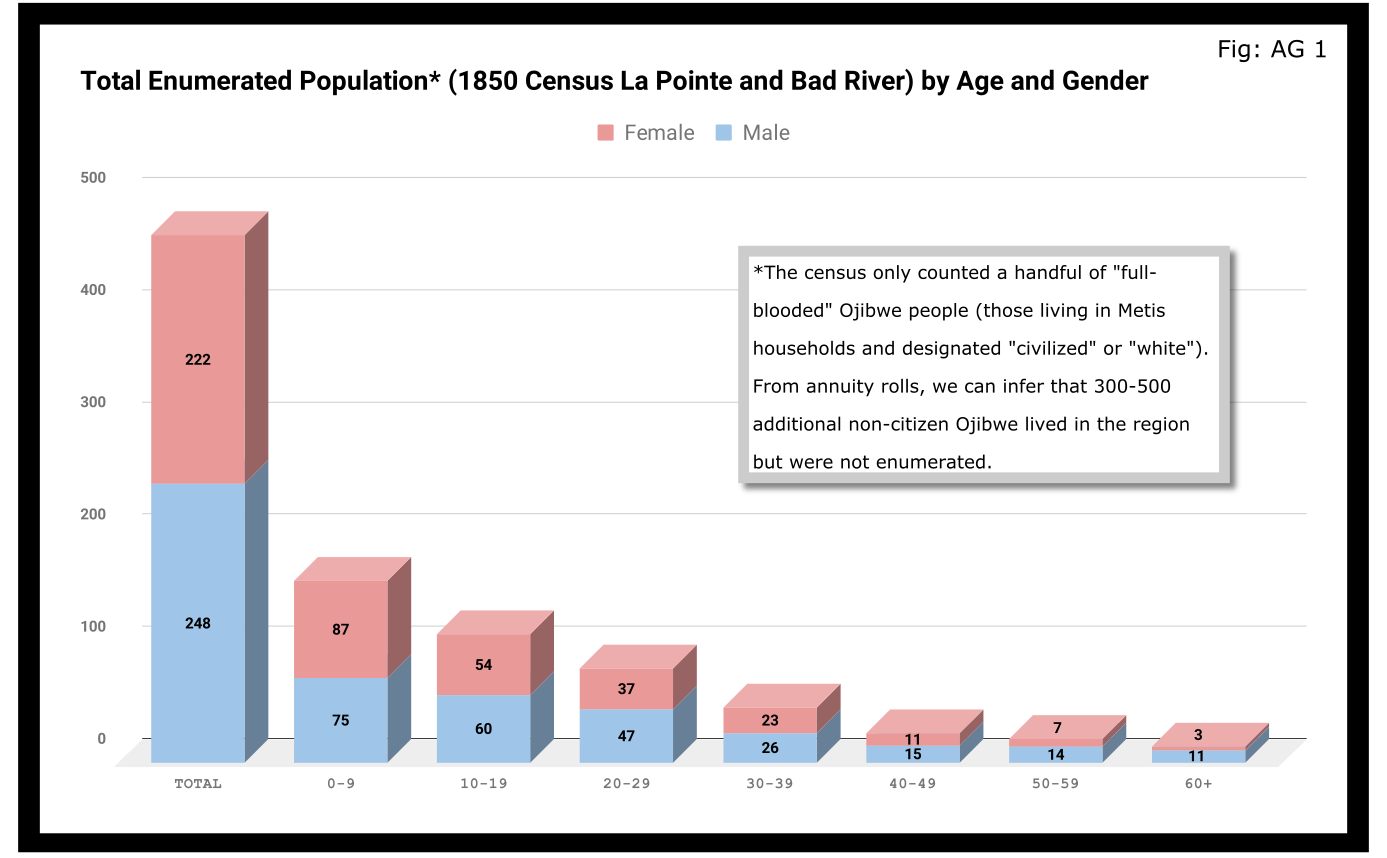
A quick glance at Figure AG 1 shows that the population skewed male 248-222 and skewed very young (61% under 20 years old). On the eve of Sandy Lake, the natural increase in the population seemed to be booming.

The hypotheses that women had higher mortality rates and were more likely to be undercounted looked good until we limit the data to the Wisconsin-born population. In Figure AG 2, we see that the male majority disappears entirely. The youthful trend, indicating large families and a growing population, continues with 66% of the Wisconsin-born population being under 20.

The male skew of the total population was entirely due to those born outside Wisconsin. This is not surprising given how much we’ve emphasized the number of men who came into the Lake Superior country to marry local women.
A look at the oldest residents in chart AG 2 and AG 3 hints at another story. Madeline Cadotte is the only Wisconsin-born person over seventy to be counted. The oldest men all came from Michigan and Canada. Why? My hypothesis is that between the fall of New France in 1759 and the establishment of Michel Cadotte’s post sometime around 1800, there wasn’t a large population or a very active fur trade around La Pointe proper. That meant Cadotte’s widow and other full bloods were the oldest locally-born residents in 1850. Their Metis contemporaries didn’t come over from the Soo or down from Grand Portage until 1810 or later.
Economics
Before the treaties, the economy of this area was built on two industries: foraging and trade. Life for Ojibwe people revolved around the seasonal harvest of fish, wild rice, game, maple sugar, light agriculture, and other forms of gathering food directly from the land. Trade did not start with the French, and even after the arrival of European goods into the region, the primary purpose of trade seemed to be for cementing alliances and for the acquisition of luxury goods and sacred objects. Richard White, Theresa Schenck, and Howard Paap have all challenged the myth of Ojibwe “dependence” on European goods for basic survival, and I find their arguments persuasive.
Trade, though, was the most important industry for Metis men and La Pointe was a center of this activity. The mid-19th century saw a steep decline in trade, however, to be replaced by a toxic cycle of debts, land sales, and annuity payments. The effects of this change on the Metis economy and society seem largely understudied. The fur trade though, was on its last legs. Again, the Austrian travel writer Carl Scherzer, who visited La Pointe in 1852:
After this discussion of the of the rates of the American Fur Company and its agents, we want to add some details about the men whose labor and time exerted such a great influence on the fate and culture of the Indian tribes. We wish to add a few explanatory words about the sad presence on La Pointe of the voyageurs or courriers du bois.
This peculiar class of people, which is like a vein of metal that suddenly disappears within the bedrock and reappears many hundreds of miles away under the same geological conditions, their light reaches the borders of the eastern Canadas. The British people, with their religion and customs, reappeared on the shores of these northern lakes only in 1808 with the Fur Company. For labor they drew on those who could carry their wares across the lakes and communicate with the Indians.
Many young men of adventurous natures left the old wide streets of Montreal and moved into the trackless primeval forests of the West. Young and strong as laborers, they soon started to adopt the lifestyle and language of the aborigines. They married with the Indians and inhabit small settlements scattered throughout those mighty lands which begin at Mackinow Island and come up the upper lake to the region of Minnesota. They almost all speak the Canadian patois along with the language of the Chippewas, the tribe with which they came into kinship. We found only a few, even among the younger generation, who understood English.
Since then, every day the population of the otherwise deserted shore of Lake Superior increases with the discovery of copper mines. The animals driven away by the whirlwind of civilization toward the west, attract the Indians with their sensitive guns, leaving La Pointe, abandoned by the Company for their headquarters at St. Paul in Minnesota. Most voyageurs left the island, having seen their business in ruins and lacking their former importance. Just a few families remain here, making a meager livelihood of hunting, fishing, and the occasional convoy of a few travelers led by business, science, or love of nature who purchase their limited resources.
From Scherzer’s description, two things are clear. It’s pretty clear from the flowery language of the Viennese visitor.Washington Irving and other Romantic-Era authors had already made the Voyageur into the stock stereotypical character we all know today. Th only change, though, is these days voyageurs are often depicted as representatives of white culture, but that’s a post for another time.
The second item, more pertinent to this post, is that a lot of voyageurs were out of work. This is especially relevant when we look at our census data. Daniel Johnson recorded the occupations of all males fifteen or over:
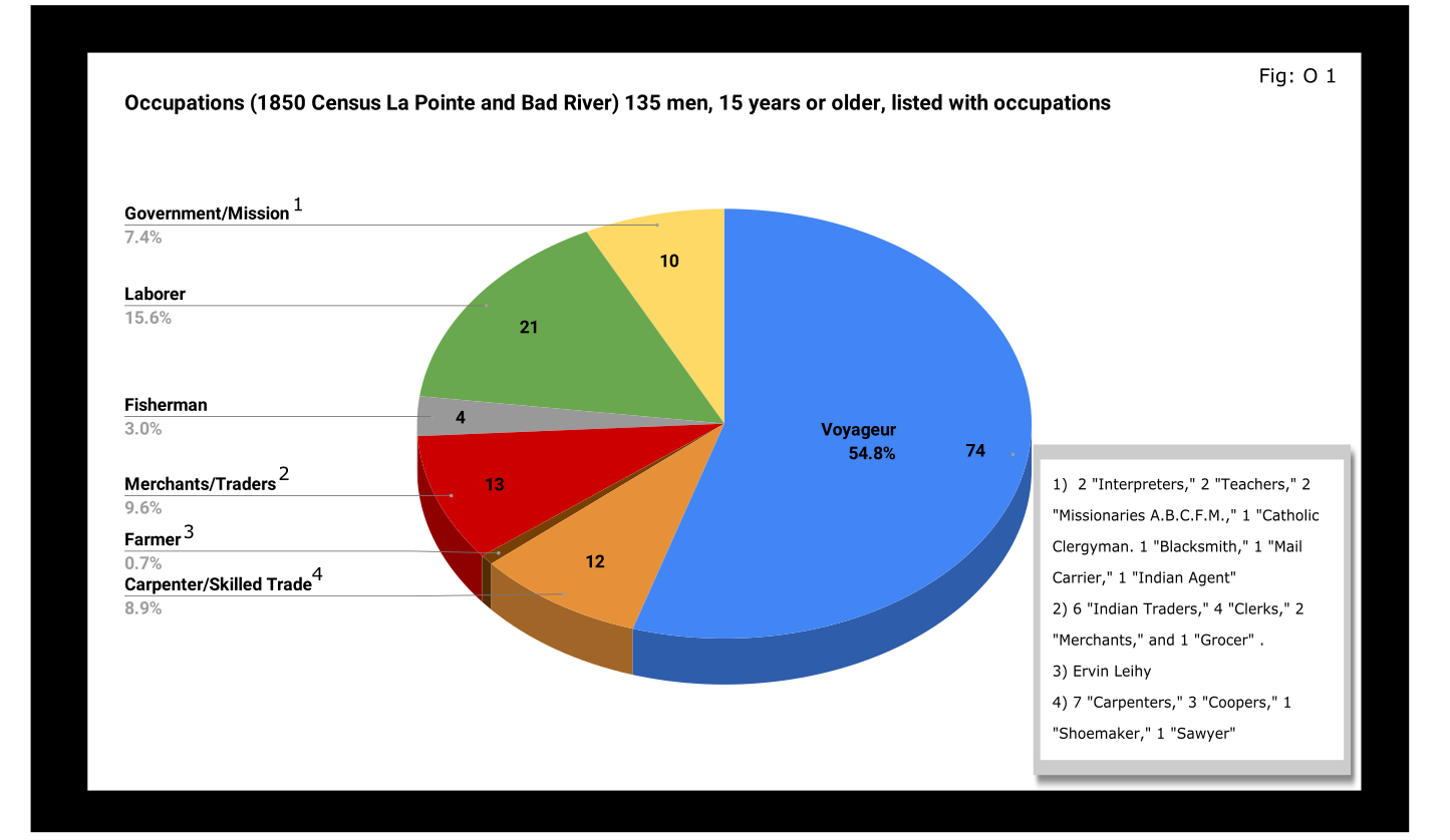
A full 55% of enumerated men fifteen and older still identified themselves as voyageurs in 1850. This included teenagers as well as senior citizens. All were from Metis households, though aside from farmer, all of the other occupation categories in Figure O 1 included Metis people.

A look at household sizes did not show voyageurs having to support significantly larger or smaller families when compared to the other occupation categories.
The other piece of economic data collected was value of real estate. Here we see some interesting themes:

If real estate is a good proxy for wealth in a farming community, it is an imperfect one in the Chequamegon area of 1850. If a voyageur had no home but the river and portage, then we might not expect him to put his coin into land and buildings. A teacher or Indian agent might draw a consistent salary but then live in supplied housing before moving on. With that caveat, let’s dig into the data.
Excluding the single farmer, men in the merchant/trader group controlled the most wealth in real estate, with Julius Austrian controlling as much as the other merchants combined. Behind them were carpenters and men with specific trades like cooper or shoemaker. Those who reported their occupation generally as “laborer” were not far behind the tradesmen. I suspect their real estate holdings may be larger and less varied than expected because of the number of sons and close relatives of Michel Cadotte Sr. who identified themselves as laborers. Government and mission employees held relatively little real estate, but the institutions they represented certainly weren’t lacking in land or power. Voyageurs come in seventh, just behind widows and ahead of fishermen of which there were only four in each category.
It is interesting, though, that the second and third richest men (by real estate) were both voyageurs, and voyageur shows a much wider range of households than some of the other categories: laborers in particular. With the number of teenagers calling themselves voyageurs, I suspect that the job still had more social prestige attached to it, in 1850, than say farmer or carpenter.
With hindsight we know that after 1854, voyageurs would be encouraged to take up farming and commercial fishing. It is striking, however, how small these industries were in 1850. Despite the American Fur Company’s efforts to push its Metis employees into commercial fishing in the 1830s, and knowing how many of the family names in Figure O 3 are associated with the industry, commercial fishing seemed neither popular nor lucrative in 1850. I do suspect, however, that the line between commercial and subsistence fishing was less defined in those days and that fishing in general was seen as falling back on the Indian gathering lifestyle. It wouldn’t be surprised if all these families were fishing alongside their Ojibwe relatives but didn’t really see fishing (or sugaring, etc.) as an occupation in the American sense.
Finally, it could not have escaped the voyageurs notice that while they were struggling, their former employers and their employers educated sons were doing pretty well. They also would have noticed that it was less and less from furs. Lump annuity payments for Ojibwe land sales brought large amounts of cash into the economy one day a year. It must have felt like piranhas with blood in the water. Alongside their full-blood cousins, Metis Ojibwe received these payments after 1847, but they had more of a history with money and capitalism. Whether to identify with the piranha or the prey would have depended on all sorts of decisions, opportunities and circumstances.
Education and Literacy
The census also collected data on education and literacy, asking whether children had attended school within the year, and whether adults over twenty could read and write. The history of white education efforts in this area are fairly well documented. The local schools in 1850 were run by the American Board of Commissioners of Foreign Missions (A.B.C.F.M.) at the La Pointe and Odanah missions, and an entire generation had come of age at La Pointe in the years since Rev. Sherman Hall first taught out of Lyman Warren’s storehouse in 1831. These Protestant ministers and teachers railed against the papists and heathens in their writings, but most of their students were Catholic or traditional Ojibwe in religion. Interestingly, much of the instruction was done in the Ojibwe language. Unfortunately, however, the census does not indicate the language an individual is literate in. I highly recommend The Ojibwe Journals of Edmund F. Ely, 1833-1849 if you are interested in these topics.
To start with, though, let’s look at how many people were going to school:

Thirty-nine students had gone to school in the previous year. There is a lot of sample-size noise in the data, but it seems like ages 7-11 (what we would call the upper-elementary years) were the prime years to attend school.

Overall, most children had not attended school within the year. Attendance rates were slightly higher for boys than for girls. White children, all from two missionary families, had a 100% attendance rate compared to 24% for the Metis and “Civilized Indian” children.
We should remember, however, that not attending school within the year is not the same as having never attended school. Twelve-year-old Eliza Morrin (later Morrison) is among the number that didn’t attend school, but she was educated enough to write her memoirs in English, which was her second language. They were published in 2002 as A Little History of My Forest Life, a fascinating account of Metis life in the decades following 1854.
Eliza’s parents were among the La Pointe adults who could read and write. Her aunt, uncle, and adult cousins in the neighboring Bosquet (Buskey) house were not. Overall, just over half of adults over 20 were illiterate without a significant gender imbalance. Splitting by birthplace, however, shows the literacy rate for Wisconsin-born (i.e. Metis and “Civilized Indian”) was only 30%, down from the overall male literacy rate of 48%. For Wisconsin-born women, the drop is only three points, from 47% to 44%. This suggests Metis women were learning to read while their husbands and brothers (perhaps en voyage) were not.

And this is exactly what the data say when we split by occupation. The literacy rate for voyageurs was only 13%. This beats fisherman–all four were illiterate–but lagged far behind all other types of work.
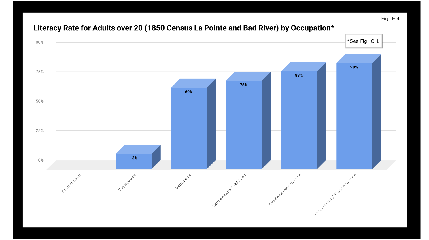
If education was going to be a factor in the economic mobility of unemployed voyageurs, the trends weren’t looking good.
Odds and Ends
Two marriages were reported as occurring in the year previous to the census: Peter and Caroline Vanderventer and Pierre and Marguerite Robideaux (ak.a. Peter and Margaret Rabideaux). Though married, however, Caroline was not living with her husband, a 32-year old grocer from New York. She (along with their infant daughter) was still in the home of her parents Benjamin and Margaret Moreau (Morrow). The Vanderventers eventually built a home together and went on to have several more children. It appears their grandson George Vanderventer married Julia Rabideaux, the granddaughter of Peter and Margaret.
I say appears in the case of George and Julia, because Metis genealogy can be tricky. It requires lots of double and triple checking. Here’s what I came across when I once tried to find an unidentified voyageur known only as Baptiste:

Sometimes it feels like for every Souverain Denis or Argapit Archambeau, there are at least 15 Jean-Baptiste Cadottes, 12 Charles Bresettes, 10 Francois Belangers and 8 Joseph DeFoes. Those old Canadian names had a way of persisting through the generations. If you were a voyageur at La Pointe in 1850, there was nearly a 30% chance your name was Jean-Baptiste. To your friends you might be John-Baptist, Shabadis, John, JB, or Battisens, and you might be called something else entirely when the census taker came around.
The final column on Daniel Johnson’s census asked whether the enumerated person was “deaf and dumb, blind, insane, idiotic, pauper, or convict.” 20 year-old Isabella Tremble, living in the household of Charles Oakes, received the unfortunate designation of idiotic. 26-year-old Francois DeCouteau did not have a mark in that column, but had “Invalid” entered in for his occupation. It’s fair to say we’ve made some progress in the treatment of people with disabilities.
Final Thoughts
I am not usually a numbers person when it comes to history. I’ll always prefer a good narrative story, to charts, tables, and cold numbers. Sometimes, though, the numbers help tell the story. They can help us understand why when Louis Gurnoe was killed, no one was held accountable. At the very least, they can help show us that the society he lived in was under significant stress, that the once-prestigious occupation of his forefathers would no longer sustain a family, and that the new American power structure didn’t really understand or care who his people were.
Ultimately, the census is about America describes itself. From the very beginning, it’s never been entirely clear if in E. pluribus unum we should emphasize the pluribus or the unum. We struggled with that in 1850, and we still struggle today. To follow the Department of Commerce v. New York citizenship case, I recommend Scotusblog. For more census posts about this area in the 19th century, keep following Chequamegon History.
Sources, Data, and Further Reading
-
Paap, Howard D. Red Cliff, Wisconsin a History of an Ojibwe Community ; Volume 1 The Earliest Years: the Origin to 1854. North Star Press of St. Cloud, Inc., 1854.
-
Satz, Ronald N. Chippewa Treaty Rights: the Reserved Rights of Wisconsin’s Chippewa Indians in Historical Perspective. University of Wisconsin Press, 1997.
-
Original Census Act of May 23, 1850 (includes form and instructions for marshals). (PDF)
-
Compiled data spreadsheets (Google Drive Folder) I’ll make these a lot more user friendly in future census posts. By the time it occurred to me that I should include my tables in this post, most of them were already done in tally marks on scrap paper.
-
Finally, these are the original pages, scanned from microfilm by FamilySearch.com. I included the image for Fond du Lac (presumably those living on the Wisconsin side of the St. Louis River) even though I did not include it in any of the data above.
-

- Bad River
-
- Fond du Lac (not included in above data)
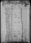


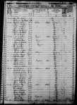

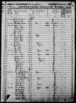
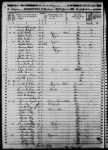


Copper Creek Mining Location
November 18, 2016
By Amorin Mello

—
COPPER CREEK MINING LOCATION.
—
This location embraces the east half of the southeast quarter of Section 15, and the west half of the southwest quarter of Section 14, in Township 47, Range 14 west, being 160 acres in Douglas County, Wisconsin. It is about thirteen and one-half miles by the County road from the town and harbor of Superior, and at an elevation of 300 feet above the level of the lake.
The Aminecon Trap Range, in crossing it from southwest to northeast, is cut by Copper Creek, a rapid and never-failing stream, exposing at several points veins of native copper.
~ Mine Register: Successor to the Mines Handbook; Volumes 8-9, page 205.
“We all lived in the log house until December 31, 1845, when I left for Iron River [Michigan] under agreement to mine for the Boston North American Mining company, organized by the American Fur company, under the management of Messrs. Borup and Oakes.”
~ Michigan Historical Collections: Volume 2; page 688.
These surface exposures attracted, at an early day, the attention of the agents of the American Fur Company, then the only civilized occupants of that part of the country, and in the years 1846 and 1847 some attempts at mining were made under their direction. A particular description of their operations will be found in another part of this pamphlet. As they had no title to the land and were working at great expense in a region which was at that time wholly remote from civilization, it is not surprising that like many other pioneers in Lake Superior copper-mining, they abandoned their enterprise, or postponed it to a more convenient season.
Eight years afterwards, the whole southern shore of Lake Superior had ceased to be exclusively known to hunters and trappers. The land had been surveyed and brought into market, and settlement had extended to the extreme western end of the lake.

James H. C. McKinzey was issued his patent to the Copper Creek Mining Location by the Willow River Land Office on August 1st, 1854.
~ General Land Office Records
The Copper Creek location was then entered under a preëmption claim by J. H. C. McKinzey, and after a litigation at the Land Office with a rival preëmptor in the interest of members of the Fur Company (who now made a persistent effort to secure a title to the land), McKinzey’s claim was sustained, and a patent was duly issued to him. From him the title passed, with but one intervening link, to the present proprietor.
The location has been visited from time to time by explorers, practical miners, and geologists; numerous rich specimens have been taken from it, and it has long been reputed to be the most promising mining location west of Ontonagon. During the past season a regular exploration has been made upon it, with the view of ascertaining more definitely its value for mining purposes.
“This Township has a clay soil. The small streams are all muddy and go nearly dry in summer. A copper bearing trap range extends through the middle of Township. On the south side of these hills it is well timbered with valuable Pine Cedar Sugar & Black Ash. Copper has been obtained on the SE 1/2 of Section 21 & upon Sections 14 & 15. The streams [reaching?] into Black River are all very rapid.”
~ Wisconsin Public Land Survey Records
A Report of this exploration is presented herewith. Mr. George R. Stuntz, under whose superintendence it was conducted, is an explorer of great experience, with a knowledge of the geological formations characteristic of the copper-bearing districts of Lake Superior, acquired by careful study in the field. He was the original surveyor, under government contract, of the whole Wisconsin shore of the lake, and has, perhaps, a more thorough acquaintance with that region than any person could be named. His Report is a plain statement of facts, and as the undersigned was himself present and taking part in the exploration, he is able to vouch for its accuracy. In connection with the maps, and with the specimens to which it refers (which were marked and packed on the ground by the writer’s own hand), it will furnish a correct idea of the character of the location.
It will be seen that there are three well-defined veins, two of which, including the one from which the richest specimens were obtained, run with the formation. This last mentioned lode rests upon a foot-wall of the most productive veins of the Minnesota mine. Although only three veins have been actually traced, there is reason to believe that others would be discovered by a further exploration, as many points inviting examination were passed by, owing to the lateness of the season.
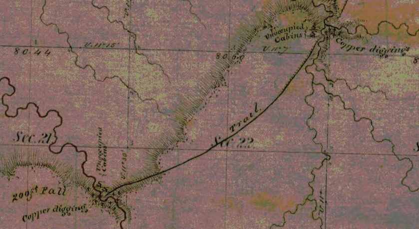
Detail from George Riley Stuntz’s original survey map of Township 47 North, Range 14 West: copper mines, abandoned cabins, and a tote road in what is now Pattison State Park. The northeast feature is Copper Creek and the southwest feature is Big Manitou Falls.
~ Wisconsin Public Land Survey Records
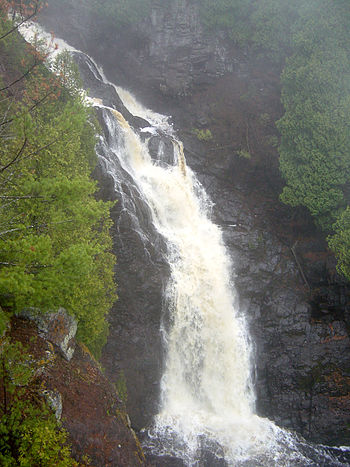
“Big Manitou Falls, the tallest waterfall in Wisconsin, in Pattison State Park just south of Superior, Wisconsin, USA.” Photograph from
Bobak Ha’Eri shared with a Creative Commons license.
The facilities furnished by Copper Creek for stamping purposes will be apparent from an inspection of the map. The town of Superior, having a good harbor, with piers and warehouses, erected by private enterprise, presents every convenience for shipping copper and obtaining supplies. Beef cattle, driven over from Minnesota, on the military road, can be purchased here much cheaper than at the Michigan mines, which are now largely supplied from this point. Pork can be advantageously procured in the same way. Another advantage is found in the price of lumber, an article for which the pineries and sawmills in this region now find a market at the lower mines. One of the finest bodies of pine in the north-west is found on the Brulé and Iron Rivers, about twenty-four miles east of this point.
With reference to the transportation between Superior and Copper Creek, it may be mentioned that, besides the wagon road (which is now available during the winter, and at no great expense can be made so at all times), the Nemadji River which, at ordinary stages of water is navigable for small boats to a point within four miles of the location, affords an additional route.
There is reason to believe that the whole country at the westerly end of Lake Superior will receive a new stimulus to its development before many years, by the opening of railroad communication with the Mississippi River, an enterprise which is becoming the absolute necessity to the interests of Minnesota. Meanwhile communication is kept open by means of the Point Douglas military road and a regular line of stages between St. Paul and Superior, which place is thus rendered accessible at all seasons.
JAMES O. SARGENT.
Boston, Dec. 8th, 1863.
—
REPORT OF EXPLORATION.
(ACCOMPANYING SPECIMENS.)
—
Superior, Oct. 17, 1863.
JAMES O. SARGENT, ESQ.
SIR : Under instructions from you, I have made a survey of the east half of the southeast quarter of Section 15, and the west half of the southwest quarter of Section 14, Township 47 north, Range 14 west, in Douglas county, Wisconsin, and have explored the same as thoroughly as the limited time and the small force under my direction would permit.
I herewithin submit a copy of the field-notes of the survey, and a map of the location.
In making the exploration I had the services of Mr. George Walker, an English miner, who has had several years’ experience in the various copper mines on this lake.
The tract is thickly timbered with spruce, fir, aspen, sugar, oak, white pine, and birch. This timber is small in size.

The Aminecon Trap Range crosses the location. This Range makes its appearance above the sandstone on the east side of Township 48 north, Range 12 west, about the middle of the township, runs in a southeasterly course across the township, and across Township 47, Range 13, Township 47, Range 14, Township 46, Range 15, and leaves Wisconsin. It is cut by the Aminecon River, Copper Creek, and Black River, and numerous small streams. Throughout the extent described it gives promise of being a productive mining district.
Two small streams unite near the centre of the location, forming Copper Creek, which runs in a northwest direction, and leaves the tract about twenty rods south of the northwest corner. Owing to the extremely dry season, this stream was lower at the time of my examination than it has been known to be in ten years; but it affords at all times abundance of water for the purposes of a mine employing steam power.
By a measurement, taken October 1st, I found the amount of water passing through it to be 58 5/10 cubic feet per minute, and this is very much below the average. In ordinary seasons the amount of fall in the stream (which is from fifty to a hundred feet within the location) would give a water power sufficient for all the purposes of a mine.
From my examination I believe that there are three veins, as represented in the map, in all of which we obtained native copper.
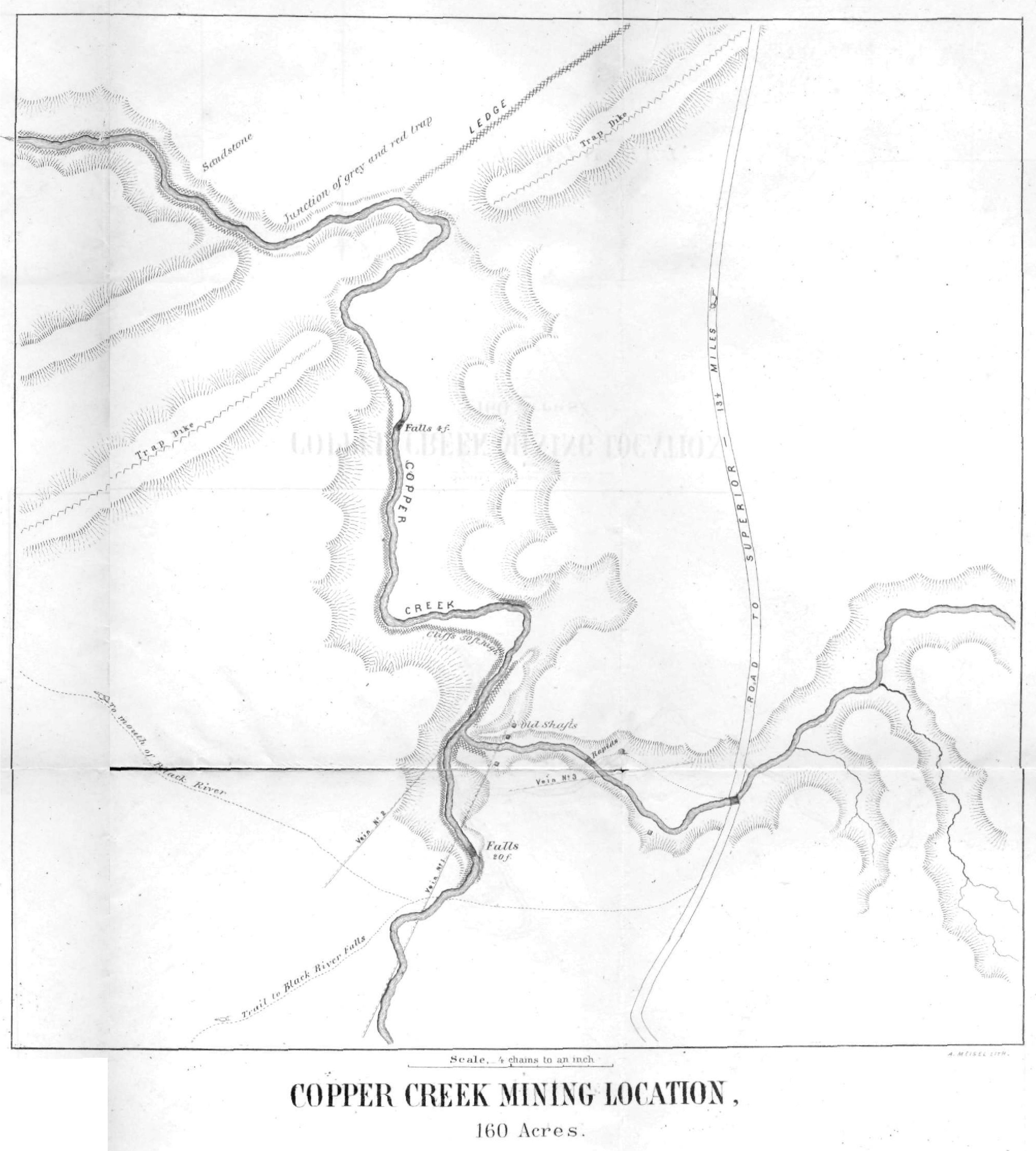
Vein No. 1 shows a breast in the east bank of the west branch of the stream, of nearly twenty feet wide, and bears south twenty-four degrees west. The specimens taken from this locality are numbered, and, as you will perceive, exhibit a quality of vein-stone which gives promise of productiveness. This vein has been traced to the southwest and adjoining location. It dips to the southeast at an angle of thirty-three degrees. The productive part of the lode lies upon the foot-wall, specimens of which I furnish with this Report, as also of the hanging wall.
Vein No. 2 shows a breast of over thirty feet in the bluff east of the stream, and appears to run in a northeast course. My explorations were not carried far enough to fully define its course in that direction. Surface specimens of the vein and of the adjacent trap are furnished herewith.
Vein No. 3 cuts the east branch of the creek, and bears north eighty-two degrees east. We opened this vein in four places at the creek, within two hundred feet. It has the appearance of being very much disturbed. On the west side of the stream, it is very compact and filled with quartz-lined cavities interspersed with crystals supposed to be malachite. It dips to the northwest. Specimens from this locality, a full collection of which is furnished, warrant a more thorough examination.
Vein No. 2, before referred to, as showing a breast of thirty feet in the east bluff, appears to branch or to be thrown out about eighty feet in crossing the creek bottom; my limited time and means did not permit me to determine which.

About two hundred feet below the junction of the two branches of the creek it shows at the foot-wall in the bed of the stream. A few feet west of this, the lode rises in the bluff on the west side of the stream. Course of stream at this point north twenty-eight degrees east. Course of vein north forty-two and one-half degrees east. At this junction of the streams, the lode, stripped of its hanging-wall, rises to the top of the cliff, a height of forty or fifty feet. At this point, we blasted into the lode, and found it rich in copper, some pieces weighing from six to fifteen pounds, and with rich stamp-work. See specimens marked Vein No. 2, west of stream.
About fifty feet above the forks of the stream the lode rests upon a bed of conglomerate. This conglomerate is highly metamorphosed, and is amygdaloidal. See specimens.
About one hundred feet west of this, we opened the vein on the brow of the hill. It there shows a breast of twenty feet, and dips to the southeast at an angle of thirty-five degrees.
~ Duluth and St. Louis County, Minnesota: Their Story and People; Volume 1, page 66.
This location was worked to some extent in the years 1846 and 1847, under a lease from the General Government, by the American Fur Company. They sunk four shafts, but appear to have done very little surface exploring.
Three of these shafts are sunk on the course of Vein No. 1, and from my examination appear to have been perpendicular. Their location is given on the map. The timbering is so much decayed that I did not venture to work in them. From soundings, I found the shaft between the streams forty-six feet deep, the next one on the east side of east branch twenty-eight feet deep, and the one east of section line twenty-eight feet deep. All of them have water to within about twelve feet of the surface. The fourth shaft is sunk at the bend of the east branch. This is thirty-five feet deep, and does not appear from the burrow to have been upon any vein.
The first three shafts above described were sunk perpendicularly upon the outcrop of a vein dipping thirty-three degrees, and therefore pass into a foot-wall. Had they been continued, they would have cut Vein No. 2. They may perhaps be made available in a further exploration.
Upon the adjoining location, to the westward, is a vein discovered by John Parry, some years ago. I have taken some specimens from it which are herewithin furnished. This vein runs north eighty-two degrees east, and intersects your western boundary six chains north of the southwest corner. It appears to be a continuation of Vein No. 3.
At the junction of the trap with the sandstone, in the northwest corner of the location, in the bed of Copper Creek, a bed of bluish-white grindstone grit of first-rate quality is found. The layers are from one inch to several inches in thickness. This white sandstone appears to belong to a different period from the red sandstone of Lake Superior. It only shows to the height of a few feet, and is overlaid by sixty feet of the red sandstone.
In the vicinity of the trap dike it is bent and fractured and considerably hardened. Near the junction, as marked on the map, it is tilted until some of the layers stand perpendicular. There are no ripple-marks on this white sandstone, while the red, resting upon it, shows evidence of a strong current.

Portrait of George Riley Stuntz from The Eye of the North-west: First Annual Report of the Statistician of Superior, Wisconsin, by Frank Abial Flower, 1890, page 26.
This tract of land is thirteen and one-half miles from the town of Superior, at the west end of Lake Superior. It is on a County Road which has been nearly completed, is now practicable for winter use, and can be made a good summer road at an expenditure not exceeding $2,000.
The soil is a sandy loam, with a subsoil of red clay containing a large per centage of marl, and is quite productive, being capable of producing a large portion of the vegetables needed by the operatives at a mine. It is especially adapted to the cultivation of grass and oats. Timber for lumber and fuel can be obtained conveniently and in unlimited quantity.
Respectfully submitted,
GEORGE R. STUNTZ,
Surveyor in charge of Exploration.
Two Months In The Copper Region
May 21, 2016
By Amorin Mello
This is a reproduction of Colonel Charles W. Whittlesey’s article, “Two Months in the Copper Region,” as published in the National Magazine and Industrial Record, Volume II., Number IX., February 1846, by Redwood Fisher, pages 816-846. For more information about these places and people, please refer to Copper Harbor, The Copper Region, and Copper Harbor Redux in the Wisconsin Territory Delegation, which occurred only a few weeks previous to Whittlesey’s experience.
TWO MONTHS IN THE COPPER REGION.
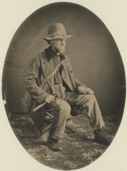
“Studio portrait of geologist Charles Whittlesey dressed for a field trip.” Circa 1858.
~ Wisconsin Historical Society
It was on the 14th day of August, 1845, that our party went on board a light and well-built yawl, of about four tons, moored in the still water above the rapids of the St. Mary’s river. We were venturing upon an experiment. We could not learn that such a craft had ever put forth alone upon the waters of Lake Superiour, and our intention was, to follow the south coast as far as the season would permit. For hundreds of years this lake had been navigated by the bark canoe, and parties were setting off every day for Copper Harbour, La Pointe, and other remote points, in these apparently frail vessels, but which the experience of centuries, in these apparently frail vessels, but which the experience of centuries had demonstrated to be the safest conveyance known. The Mackinaw boat had long traversed these shores, transporting goods to the Fur Company’s posts, and returning with furs.
These long, narrow, flat-bottomed boats, carry a heavy burden, go well before the wind, and are easily drawn ashore. The bark canoe, as well as the Mackinaw boat, has no keel, and the safety of both consists in being able to make a harbour of every sand beach, in case of a storm. The expert voyager, has a kind of second sight in regard to weather, smelling a storm while it is yet a great way off. It is only when a great saving may be made, and the weather is perfectly fair, that he ventures to leave the vicinity of the shore, and cross from point to point, in the open sea. These passages are called “traverses;” and such si the suddenness with which storms arise, that a traverse of 10 or 15 miles, even in fair weather, and while every indication is favourable, is regarded as a hazardous operation. Some daring boatmen make them of 30 miles.
Of course, the birch canoe and the Mackinaw boat, being without keels, cannot sail upon the wind. Our yawl, with a keel of four inches, having nine men and about a ton of provisions aboard, sank about 16 inches in the water. She was provided with a cotton square-sail, containing about 40 square yards, and had row-locks for six oars. How she would row – how she would sail, and how she would brave the storm, we could only surmise, and the surmises were rather against the little vessel.
The portage, over which goods now pass, from the level of Lake Huron to that of Lake Superiour, is a flat, wet, marshy piece of land, about three-fourths of a mile across. To the westward, the country appears to be low and swampy, as far as the view extends; which, however, is limited by the thick timber, principally spruce, pine, white cedar, birch, and hemlock. But a walk of one mile, in that direction, brought me to a low eminence, rising out of a cedar swamp, composed of masses of rolled granite and other primitive rocks, in size from a small pebble to a diameter of ten feet. The timber among them had been lately blackened by a raging fire. The trunks of these charred trees, some standing erect, some leaning against others, and many prostrate on the rocks, contrasted hideously with the white and nakedness of those immense granite boulders, which covered the surface.
![Detail of Sault Ste Marie from Carver [Jonathan], Captain. Journal of his travels with maps and drawings, 1766. ~ Boston Public Library](https://chequamegonhistory.com/wp-content/uploads/2016/05/carver-detail-of-sault-ste-marie.jpg)
Detail of Sault Ste Marie from Carver [Jonathan], Captain. Journal of his travels with maps and drawings, 1766.
~ Boston Public Library
Our tents were struck at 7 o’clock, A.M., and the journey began. There were other parties scattered about the open space at the warehouse; some had regular tents, some sheltered themselves under a broad piece of India rubber cloth, stretched over a pole like the roof of a house. One party had a conical tent, with an upright pole in the centre, the canvass spread out around the foot; and another, in default of other covering, lay snoring under a cotton bedtick, stretched across the bushes. A party of surveyors were encamped near the landing, from a cruise of three months in the interiour. This party had run a tier of townships, from Mackinaw, northward, into sections of one mile square. These men encamped a few days at this place, to recruit their tattered garments, of which only the shreds and fragments remained. In enterprises of this sort, it is only by physical energy, and great powers of endurance, that the contractor can realize any thing from the prices allowed by Government for its original surveys. They provision themselves, by carrying all on their backs, from the depots on the shore. The thickets through which they pursue their work, week after week, and month after month, would be declared absolutely impracticable to a person not trained in that school, especially in the vicinity of the lake. No beast of burden could pass without bridges, even in case a pathway should be cut through the matted evergreens that cover the ground. To make a path for a horse or mule, would consume more time and labour per mile than the survey itself. There is a hardy class of Frenchmen and half-breeds, cousin-german to the Canadian voyageur, called “packers;” they were bred in the service of the Fur Companies, to carry goods from the nearest landing to the trading post, and return with a pack of furs. The surveyors found these packers indispensable to their operations. They will carry from 50 to 70 pounds, and can travel along in the recesses of the forest, without fear of losing their way.
They are patient, cheerful, and obedient; in fact, they are on land what the voyageur is upon the water. His capacity for food corresponds with his ability to endure fatigue, and his great care is to secure it in sufficient quantity. He makes, with a little instruction, an excellent axeman and chainman. If circumstances prevent a return to the camp, or the rendezvous, he can lie down at the foot of a tree, sleep till daybreak, and resume his tramp without complaint.
The party which joined our encampment here, was a subject for Catlin, the Indian sketcher. More hale, hearty, and jovial fellows, never broke into the limits of civilization. The northern atmosphere had tinged their cheeks with red, they were all young and active men, glowing with that high animal life, that extreme buoyancy of spirits, which is a stranger to the inhabitants of cities – to those who toss upon feather beds, and live upon soups and comfits.
This rugged company, full of fun and frolic, with beards of three months’ cultivation, in red flannel shirts, and fustian trowsers in shreds, white beaver hats, less the border, some in shoes, some in moccasins, and some in boots, from all of which various toes were looking out surprised even the worthy burghers of the Sault. The Sault St. Marie has been a trading post more than two hundred years. The good Catholics Ramboult and Jonges, preached preentance to the Nodowessies, or Sioux, on this spot, in 1641, whom the French traders immediately followed. Here it may be said the borders of civilization have been fixed for two centuries. In consequence, a mixed race has arisen, neither the representatives of refinement nor of barbarism, but of a medium state. It may well be supposed, that a band of jolly fellows, habited as we have described these hardy surveyors, axemen, chainmen, and packers, would not attract here that attention which they would in New-York, or in London. But they appeared to be objects of no little interest and curiosity to the worthy inhabitants of the Sault, especially as some of them were so disfigured that their old friends did not recognize them.
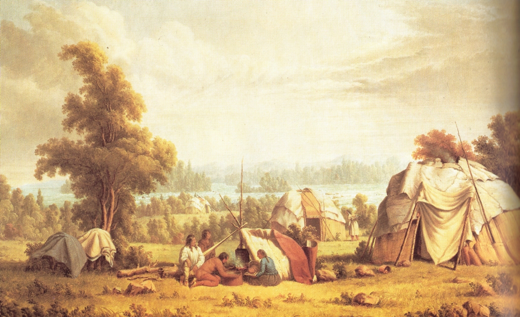
“Ojibwa village near Sault Ste Marie” by Paul Kane in 1845.
~ Commons.Wikimedia.org
Looking back from the water, upon the collection of tents and lodges, we had a view of the group at one glance, and the scene from the new point of observation suggested ideas that had not presented themselves while we formed a part of it. Around some of the camp-fires were gentlemen from the Atlantic shores, with genteel caps and surtouts, shivering in the raw wind of the morning. Poor fellows ! impelled by the hope of wealth to be found in the copper region, they had rushed, at steamboat rates, to the extremity of navigation, of taverns, and permanent habitations.
The reality of copper exploration had now commenced. A night of drizzling rain and fog had been passed, in a cold tent, on wet ground. Among them were seated voyageurs and half-breeds, as happy as a plenty of grub could take them. The raw wind was no annoyance to them, so long as there was a flint and steel to start a fire, and a plentiful stock of provisions. Between the cap and surtout, and the flannel shirt and canvass trousers, was every grade of men represented by a grade of habiliments.
In front of this motley collection of persons and things, lay the frame of a large schooner, on which fifty workmen were laying the plank – all its timbers and lumber brought from the lower lakes; and in the open level space beyond, along a track cleared through the swamp, stood the spars of a vessel, advancing on solid land towards the basin above the falls. This labour and expense of bringing vessels over land, or the timber to construct them with, is unavoidable. As far as known, there is not ship timber enough on Lake Superiour to build a schooner.
The rock which causes the rapids is a close, fine-grained, red sandstone, in thin layers, pitching to the northward. There has been much diversity of opinion among geologists, about the geological position of this rock. As I proceed, I shall again notice this rock, and its analogue, which occupies almost the entire south coast of this lake.

Map of Ohio including the Connecticut Western Reserve, the First Principal Meridian, and the Base Line. Drawn by Jerome S. Higgins, 1887.
~ Wikipedia.org
The 1st principal meridian of the U. States surveys, comes out on the waters of St. Marie’s, at the ship yard, just above the rapids. This is a true meridian, run with great care from the base line, which is about 12 miles north of Detroit. The 1st meridian is about 30 miles west of Detroit, and passing up through the peninsula of Michigan, crosses the straits near Mackinaw. By the Government system of rectangular co-ordinates, referred always to a given base and meridian, an observer knows his exact position, wherever he may be, in the surveyed portions of the U. States. Every township is six miles square, every section one mile square, every quarter section half a mile square. Every section [corner] has permanent marks on some adjacent tree, which gives the situation of that corner from its proper base and meridian. I make this explanation, to give light upon terms that I shall use hereafter. In traversing the American shore of Lake Superiour, we found, as far as the Porcupine Mountains, west of the Ontanagon, that the surveyors had preceded us. During the present and the past year they had extended the township lines to this distance along the coast, and for a part of this distance had subdivided the townships into sections. These surveys had been carried to different distances, interiour. From the base, near Detroit, numbering northward, St. Marie’s is in township No. 47 North, range No. 1 East. But our point of embarkment was on the west side of the meridian, in town 47 North, range 1 West, or 282 miles north of the base line.
We are now fairly under way, and shall be able to keep our reckoning. The river expands, as we ascend against a very gentle current; the shores are low and swampy, or sandy, and covered with stunted pines. In an hour and a half, so easily did our boat row, we were at “Point Aux Pins,” on the British side. At ten o’clock, we were on shore at the “Gros Cap,” looking up a spar, and clambering the red granite ridge, which here projects towards the American shore – the extremity of that range of mountains in view from the rapids, to the eastward. From the height of 500 feet, we could see the continuation of this range, westward, into Michigan, until its summit were lost int eh mist. The western extremity of the American range is “Point Iroquois,” nearly opposite “Gros Cap,” where the Chippeways, by their ancestors, fought a great battle with the Iroquois, long before the French came into these waters. The range is called the “Tequamenon Mountains,” overlooking for some 20 miles a deep bay, known as the Tequamenon Bay. The waters about “Gros Cap” are so clear that the bottom is seen from 50 to 60 feet below the surface.
Before leaving this inhospitable crag, we set fire to a windfall about about two years of age, and consequently in a fine state for a conflagration. This was not done through any republican contempt of the British Queen, or her territory, but from pure benevolence towards subsequent travellers exploring “Gros Cap.” It lay between the ridge and the bay, in a swamp so thickly covered with prostrate trees that one might go a quarter of a mile on them without touching the ground, unless an unlucky misstep should precipitate him into the mud beneath. At one o’clock, we were at “Isle Parisien,” a low island, five miles long, cooking a dinner, and procuring a better spar.
We succeeded here so well in fitting our sail, that the traverse of 15 miles to “White-Fish Point,” ordinarily a hazardous voyage, was safely and pleasantly made, a little after dark; and the wind, though light, being still fair, we ran into the lake without landing, and made along the shore. We were now upon the largest body of fresh water on the globe; called by the Indians, Kitche-goming, by the French, Superieur, or Upper, and corrupted by the English into “Superiour.”
The moon shone dimly through a heavy sky, the water was merely ruffled by a warm southern breeze, and in the distance the flame of the burning windfall shone conspicuously above the mountains. On the Michigan side, several large tracts of burning timbers were seen on the hills, at the head of Tequamenon Bay. It was determined to proceed as long as the wind continued favourable, but in a short time it failed altogether, and we went ashore at half-past eleven, and encamped. The ground here lay in a series of low sand ridges, with scattered pines. Distance from the Sault, 45 miles.
At sunrise every thing was on board, and the sail spread before a fair wind. Along the beach, the surf has piled a ridge of water-washed granitic gravel, five to six feet high, the deep water holding out quite to the shore. In coasting, in an open boat, the traveller must resign all hope of regularity of hours, of meals, and of sleep. His sovereign is the weather: when that is calm, he may proceed with the “white ash queen,” as the sailors say: when the wind is ahead, he can take his ease – provided he is safe on shore! But, when it is fair, he must always be before it. The prevailing winds along this shore are from the west, at this season; and, consequently, they are ahead as you go up the lake.
Breakfast on board, upon cold beans, cold pork, and hard bread.
Towards evening, the wind came so strong ahead as to oblige us to put into the mouth of “Two-Heart” river, a stream sufficiently deep to float a large vessel inside the bar, but not deep enough to carry the yawl with her load. Of the streams discharging into the lake from the south, only two or three are known with open mouths. At most of them it was necessary to lighten the boat and haul her over, with about the same labour and discomfort as though there was no channel; but once inside, a quiet harbour was always found. These mouths are so completely sealed up, and concealed by sand ridges, tat persons may pass them within ten rods of shore, and not discover that a creek is there.
The shore is composed of low monotonous sand ridges; with stunted pines. The bluff is from 50 to 80 feet high, presenting a stratified edge of sand, inclined gently to the east, not exceeding 10 feet in a mile. The ridges run from the interiour nearly perpendicular to the direction of the shore.
We passed several fishing huts, now deserted, with a plenty of empty salt barrels and fish scales scattered around.
A little east of the mouth of the creek we observed, in toiling up, several picketed enclosures, among the pines, on a beautiful ridge. They were Indian graves, thus strongly guarded to keep out the beasts of prey. There are those who doubt whether the Indian is susceptible to the delights of taste – whether he enjoys a bright morning, a clear and moonlight night, a mountain, a vale, or a beautiful river. Was it mere accident that placed this burying-ground upon so enchanting a spot? The lake is about 40 rods distant in front, and about as many feet below the site of the graves. Through the open trees you see its waters, as plainly as if there was no intervening timber – while the shade of its branches is perpetual upon the spot. Even the lowest ripple on the beach reaches the ear as distinctly as the angriest roar of the waves. Every breath of air that moves to and from the lake – the evening and the morning breeze, as well as the northern tempest, plays audibly upon the long and evergreen leaves of these ancient pines. At the head of each grave is a flat shingle or board, with emblems, painted in red, or rudely carved with a knife. On one, there are tree red cross-bows, and two human figures – representing a man and a woman, (doubtless a husband and wife,) with clasped hands. On the reverse, a bear – probably the sign or token of the deceased. On the top, three eagle quills. Some have crosses – indicating that a good Catholic sleeps below.
At an early hour on the morning of the 16th we got out of “Two-Heart” river through a light sea, determined to try the “ash breeze” against the west wind; but, after a couple of miles hard rowing, the regular breeze prevailed: we could no longer make headway, and put about.
Notwithstanding the sand-flies and moschetoes, it was comfortable to lie down once more upon the green grass and fragrant wintergreens of that shore. The weather was warm and heavy. Some wandered through the sand-hills and stumps; some, wrapped in blankets as a defence against the flies, sought in vain for sleep; others, with the fishhook and artificial fly, rowed up the creek in pursuit of speckled trout. A good dinner and supper of these fish was the result of the expedition.
At 8 P.M. the wind became more favourable, and the boat was headed up the coast. At 10 the weather became thick, and running ashore at random, we had the first trial at hauling our craft out of the water by main force. She proved to be as easily handled on land as a Mackinaw of the same capacity; only requiring more care. In camp, we turned her over – one gunwale resting on the sand, about thirty feet from the surf; the other set upon sticks, after the fashion of a trap. Under this we all crawled, spread our blankets, and some of the party went to sleep.
“[Martin] engaged in sailing on Lake Erie from Buffalo to Detroit until 1847, when he went in the interest of a company in the latter city to Lake Superior for the purpose of exploring the copper ranges in the northern peninsula of Michigan. He coasted from Sault Ste. Marie to Ontonagon in a bateau. Remaining in the employ of the company about a year, he then engaged in a general forwarding and commission business for himself.”
Mr. J. R. Dorr, of Detroit, the principal of the expedition, had seen something of this kind of life. Mr. D. P. Bushnell , of the same place, had long been Indian agent at La Pointe; and was, of course, familiar with the country and this mode of travelling. Another gentlemen, well known on the lakes for his wit and vivacity, qualities that generally attend an excitable temperament, not being accustomed to tents, boats, and camps, found it rather uncomfortable. The sand, so soft and yielding to the foot, was as hard as a rock to the bones. The grinding of the gravel, thrown incessantly about by the waves, gave out a grating sound that had no tendency to sooth a man to rest; especially one who had been accustomed to the quiet of the third story of a boarding-house. Besides, there was some chance of the props giving out, and the trap springing upon the legs, arms and bodies projecting from beneath. Mike, an old soldier who officiated as cook; Martin, a sailor just from the whaling grounds of the Northwest Coast; Charley, a giant from the Low Countries, and Patrick, the other hand seemed to pay no attention to the hard bed, the cold wind, the noisy waves, or to the doubtful props. A sprightly young clerk of the company, fresh from the counter, though swollen and tormented by the poison of the sand-flies, took the matter like a veteran, and slept like an opium-eater.
About noon the next day we passed the “Grand Marais,” a Bay 40 miles from White-Fish Point, with six feet water on the bar, and a fine harbour.
Two men had left St. Marie’s the day before we did, in a small, but neat and clinker-built boat, with two masts and a wide keel. They were wholly unacquainted with the difficulties that lay before them; yet one of them, by the name of Axtel, had been exposed in the same boat 48 hours to the fury of a Lake Michigan storm, and therefore felt a confidence in fate. neither of them had been on Lake Superiour, and therefore knew little of its harbours, rocks, and storms. Their supplies were salt pork and bread, their furniture a camp-kettle.
Passing Grand Marais, before a smart breeze, we saw their fire in the harbour, and shortly their sail, coming up astern. Here the low, regular, dear shore of sand, suddenly changed to a lofty wall of the same material, rising from the water’s edge, as steep as it will lie, to the height of 400 feet. For 20 miles back, there had been seen near the water’s edge a stratum of pebbles, inclined, with the sandy stratum above it, to the eastward. Now the strata of sand rest on a bed of clay, with the same inclination, but only a few feet in the mile. The Grand Sable struck us with the more force, because of the sudden transition, from a low, uninteresting shore, to a bold, lofty, regular scarp, four times the height of the tallest trees. But there were upon this Sable no trees or other vegetation, either on the face towards the lake, which was nearly perpendicular, or upon the summit – all was one black pile of sand; yet so clear, so regularly stratified, and so beautifully variegated, by colours, white and red, that the prospect was not deary, but rather sublime. Imagine a straight wall of pure sand, four miles long, and four hundred feet high; the base lashed by a rough sea, its top enveloped in a heavy mist, through which rounded hillocks of white wind-blown drift occasionally rise, as the eye reaches, mile after mile, over the country behind. To me, this sight was more grand and curious than the Pictured Rocks. Whence came this mass of sand? Its upper portion has apparently been moved about by winds; its lower portions appear to be too solid to be thus moved. Was it not in remote ages, like the low sands we have passed, but extending much further into the lake. A prevailing north wind, with sufficient force to move the sand at the surface, would overcome vegetation, and, like the current of a river, transport the particles incessantly in one direction. By this means the sand would pile higher and higher, and the lake always encroaching at the foot, would increase the height of the bluff shore.
The “Sable” overlies, on the west, a variegated sand rock, coarse grained, and easily broken, pitching slightly to the eastward. This is the first rock west of White-Fish Point. The stratification is imperfect, the colour, an irregular mixture of grey and red.
Turning one of the rocky points west of the “Grand Sable,” a stiff gale from the west put an end to further progress, and gave warning of a storm. The only expedient in such an emergency, is, to beach the boat, and draw her out of the reach of the waves. It is an operation not always agreeable; because, while loaded, she cannot be run upon dry ground; and, to be unloaded, the goods must be taken through the water to the shore. On this occasion the wetting process had been gone through with, two hours before, during a heavy fall of rain.
Our baggage was scarcely safe on land when the wind blew furiously, and our two friends in the sail-boat appeared, endeavouring to make the shore, as the sea had risen so much, that a landing was at this moment not only uncomfortable, but a little hazardous.
As the storm increased, our fires began to burn brightly. Near the boats, was a little dell, sheltered by a low ridge of sand, where our tents were pitched, and all made dry and comfortable, while the gale heightened into a tempest.
On the next day, progress was impracticable, and being well provided, we determined to give an entertainment. our friends were invited at 1, P.M. They had bean soup, boiled ham, tea and coffee, bread, and pickles. The quantity consumed, probably exceeded that of ordinary dinners, as much as it does at the annual meals of the Aldermen of New York, and London. As to style, there were tin cups and pewter platters, knives and spoons. For tables, there were the knees of the guests and a spare box; forseats, camp stools and bundles. The entertainment continued with great glee about two hours, and passed off with as much sociability and mirth as though it had been given at the Astor.
After the first hour had been spent in the enjoyment of this cheer, our guests began to refuse dishes, by way of politeness; but the ex-Indian agent put all such hesitation aside, by relating what he had done and seen in the Indian country. There was one example of an Indian eating half a bushel of wild rice at a meal. Another, of a half-breed, who was sent out to bring in a deer that had been killed some miles from the post. The half-breed lost his way, and slept in the woods one night. The next day, in the afternoon, he came in without the deer. He was asked where he had left it. “Ugh ! got him – do you s’pose a man is to starve.”
One thing is certain – in this high latitude, with its pure and healthy climate, where the enervating effects of heat upon digestion are unknown, men may eat with impunity what would be fatal to them at the south.
In commemoration of the feast, a little trout brook, which empties there, was named “Pickle Creek,” and the names of the party, neatly carved on a neighbouring birch.
False Imprisonment
One of the our guests is the son of a former sheriff in Canada, who made the journey from St. Marie’s to Fort William, by land, in the winter of 1816. The object of this trip, through a region so rough and forbidding, in the severity of the cold season, was the execution of a warrant upon Lord Selkirk, then in possession of that post. Fort William is situated about the middle of the north shore, nearly opposite the east end of Isle Royal. The warrant was issued from the King’s Bench, and had reference to some of those acts of violence that occurred between the “Hudson’s Bay Company” and the “Northwest Company.” The sheriff, whose name was [Smith], at last reached the fort, with ten men. Selkirk professed to hold, and to fight, under the ancient chartered rights of his ancestors; and when Smith presented his authority for the arrest, Selkirk fell back on his charter. Smith offered the authority of the King’s Bench; Selkirk claimed to be outside of all civil jurisdiction, and replied: “If you do not believe in my charter, here is my authority,” pointing to about 50 men, who were ready to do battle in such emergencies. He continued: “Instead of my being your prisoner, you are mine. I will treat you and your men well, yet you must take quarters in the block-house till I leave here.”
Accordingly, the sheriff was obliged to remain in custody about five months, until the opening of the season.
The timber about Pickle Creek is black and white birch, a few stunted white maples, white and yellow pine, mountain ash, spruce, balsam of fir, balsam of spruce, white cedar, and hemlock; none of it large enough to be valuable.
The next morning at 4, with a fair wind, we were on the water, having Grand Island in sight, at daybreak. This island is high and bold, like the Pictured Rocks, which lie on the mainland opposite. It bears sugar maple in profusion, and has one family (that of Mr. Williams) residing upon it; he is a thrifty farmer and trader. The variegated sandstone, as well as I could determine, here plunges to the west, and passes under the strata which compose the Pictured Rocks. The lamented Dr. Houghton regarded the red or variegated sandstone of Lake Superiour, as older than the “old red sandstone.” The Pictured Rock stratum he considered the equivalent of the “Pottsdam sandstone” of the New York Reports. This rock comes to the shore, about twenty miles in length, and has a thickness of at least five hundred feet. Grand Island is an outlier on the north.
The following is a section from the water’s edge upward, taken by the eye, at the highest point, which, according to Captain Bayfield, is 300 feet.

It will now be readily seen, how the perpendicular faces of rock are caused, which have given this passage such a frightful aspect. Vertical walls of smooth, gray rock, 200 to 300 feet high, passing to unknown depths beneath the surface; in places worn into large caverns, in others, coloured in fantastic, yet grim figures, half real and half imaginary, yellow, green, and black; shapes neither animal, nor in the likeness of any thing else that is natural, but so near the natural, as to give rise to the idea of monsters, griffins, and genii. Such are the Pictured Rocks, before which the Indian thinks of his Manitou, and the Frenchman crosses himself with profound reverence.
The soft conglomerate (No. 1) yields to the incessant wear of the wave, which, rolling from deep water, strikes with great power. When the undermining process has extended a few yards, the hard stratum next above falls, and with it the superincumbent mass. Much of this dissolves away in time, leaving the fragments of No. 2 visible, in great blocks, at various depths beneath the surface. The colours are furnished by the dripping solutions of iron, in the state of oxyde, carbonate, and sulphate; by moss growing upon the face of the rocks, and probably by the green carbonate of copper. The niches, caves, and angles, follow naturally from a rock of different degrees of hardness, acted upon by the same disintegrating force. At the mouth of a creek, where the trail from “Bay De Noquet,” (called Bodenock,) on Lake Michigan, strikes this lake, there is a hard silicious slate, approaching to flint, dark in colour, and imperfectly stratified. This bed, which appears to be limited, lies low, near the water.
Passing these dreaded rocks, the principal harbour of Grand Island, and the farm of Mr. Williams, come in view. For refuge in bad weather, this island must, in future time, be of great advantage to vessels. It has several large and deep harbours, and of itself forms a good lee, in almost all weather. On the mainland, opposite Mr. William’s, is a solitary cabin, the agency of the American Fur Company.
Between Grand Island, on the west, and the shore at Train River Point, there are two low islands, that appear to be formed of the red sandstone. At the point, this rock forms the shore, and has a rapid dip to the eastward, say 150 feet in the mile; evidently running under the Pictured Rocks, and therefore an older formation. Here it enclosed occasional pebbles of quartz, agates, and fine-grained sandstone.
The wind, which had been fair all day, on turning the point came strong ahead, against which we had hard pulling about five miles, to the mouth of Train river. our craft proved to be a fast sailer, easily beating the little clinker of our friends, before the wind; but those dauntless fellows did not rest, until, at the end of the day, they drew her into the same harbour with us. Train river, like many others, has deep water inside, but only a few inches at the entrance. Wherever we set foot on shore, the remains of previous travellers were seen. Here, the poles of many Indian lodges were standing, and the bones of a bear lay around, indicative of a feast. There were, also, dwarf cherries and whortleberries.

“Geological Map of the District Between Keweenaw Bay and Chocolate River, Lake Superior, Michigan.” By John Wells Foster, circa 1849-1854.
~ Huntington Digital Library
Passing out of the bay, in the morning, a range of mountains were visible, the ends presenting themselves near at hand, and the principal range extending westward, toward Chocolate river. From the outline, I conjecture that they are composed of primitive rocks. At the shore, the strata are still the variegated sandstone, very much tilted with thin beds of shale interstratified; apparent dip, to the northward. Making a long traverse from Train River Bay, at 5, P.M., we entered a magnificient harbour, between projecting points of granite rocks; and coasting along inside some islands, soon saw that there was a very safe and spacious shelter for shipping still further inland, accessible in any wind, with deep and quiet water inside. This bay is sometimes called Presque Isle. It commences about two miles north of the mouth of “Riviere des Morts,” six or seven miles northwest of Chocolate river, and extends to Granite Point.
Mr. Dorr being quite ill, our party remained a day. The boat anchored in a quiet nook of the harbour. Granite rocks were projecting on all sides, through the red sandstone, scorched and whitened at the points of contact. In the rear, were seen rugged mountains, covered with evergreens. This was regarded as the commencement of the copper region. Accordingly, myself and Martin sallied forth in the morning, to spy out the mineral wealth of the spot. On the south point of the bay, to our great satisfaction, we discovered a piece of green carbonate, about the size of a pea, in the hard, green stone trap; but a little further on, found, also, evidences of prior occupation, in a log cabin covered with birch bark, a small patch of chopped land, and a pen made of poles, which enclosed two or three hills of potatoes, and some stalks of green peas. Pursuing our way along the shore, to Dead Men’s river, we found a permanent fishing establishment, and two comfortable houses, now deserted and locked up.
The country adjacent, for two or three miles, is low and swampy, with sand ridges between the swales; and at the mouth of the river, heaps of granite rocks. It was soon evident that the surveyors had been this way, and that very recently. At the south point of the bay, was a stake, on the dividing line between sections Nos. 1 and 2, town 48 north, range 25 west; showing that we were one town, or six miles north of St. Mary’s, and 25 towns, or 150 miles west.
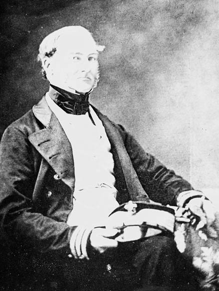
Bayfield, Wisconsin, was named in honor of Admiral Henry Wolsey Bayfield, who surveyed Lake Superior between 1823-1825. His map of Chequamegon Bay is available online here. Photograph from Dictionary of Canadian Biography.
In making the traverse from Train River Bay, to Presque Isle Bay, a singular object was visible to the right, long before the shore opposite to it came in sight. Under the effect of refraction, it rose and fell, dilated and contracted, changing continually from a tall spire to a flat belt of land. By the glass, it was seen to be almost destitute of trees, and Mr. Bushnell began to regard it as one of the peaks of Point Kewena. There is no map of this lake, upon which a navigator can rely, except a British one, from the survey of Capt. Bayfield, (Royal Navy,) made about 20 years ago. We had what purported to be a copy, but soon found that it was not a true one. We could neither recognise from it, the harbour, the points, nor the rivers, where we were. At Chocolate river the coast, from a westerly course, makes almost a right angle to the northward; but at that time, whether we were at Chocolate, or Dead Men’s river, we could not tell.
The isolated object seen in the north proved to be the “Granite Rock,” situated about 10 miles from the shore, 50 to 80 feet in height, and a few acres in extent. Along this shore, huge masses of this recent granite rise through the water, and may be seen in its clear depths. From the section stake just mentioned the Granite Rock bears north, 10 or 12 miles distant. It must not be confounded with “Standard’s Rock,” which is in the track of vessels from Point Kewena to St. Mary’s, 30 miles from land. That these granite rocks are more recent than the sedimentary sandstone which rests upon them, is evident from observation. The metamorphic rocks have protruded through the sandstone, distorting and breaking up the strata. If the red, or variegated sandstone, had been deposited after the upheaval, this disturbance would not have been visible, nor would there have been seen the discolouration and semi-vitrification at the junction, or contact of the two formations.
The mountainous country, which here comes quite to the lake, extends in east and west ranges, beyond the sources of the Huron river and Kewena Bay, and appears to have been formed by the same volcanic effort. The spacious and beautiful harbour where we lay, is formed by four granitic islands, three of them now connected with the shore by sand-bars, forming as many “Presque Isles.”
Our next day’s sail ended at a small creek, represented on the map as the St. John’s river, but by the voyageurs called Cypress river, from the adjacent forest of cypress timber, as it is called. This tree is an evergreen, with rough bark, resembling a tamarack, but the leaves are more like the hemlock. At 15 miles from Presque Isle Harbour, the shore made again to the westward, the sandstone bluff being more elevated and perpendicular; its strata somewhat rolling, but the general dip appeared to be westward. The knobs of Point Kewena were now distinctly in sight, from 40 to 50 miles distant, in the north. Mr. Door, being quite sick with a bilious fever, we determined to make a long traverse on the next day, across the bay, to Inverse Island, and thence, with all dispatch, to Copper Harbour. But after putting out, in the face of a stiff breeze, early in the day, we found it impossible to weather the next point, and returned to camp. The river called the St. John’s by us, is known to the French as the “Chien-Jaun,” or Yellow Dog river, corrupted, in the first instance, to “Shannejone,” and Thence to St. John. It is, on the map, laid down as about 30 miles long. In this country the creek is never used, but the French term “riviere,” is applied to all its streams, which is Anglicised river. Being now wind-bound for the day, I took our trusty and intelligent whaler, Martin, who had already shown himself a good woodsman, as well as a first-rate sialor, and followed the creek into the interiour. At the end of two miles of still, deep water, our canoe was obstructed by flood-wood, and at three-fourths of a mile further, by a fall of 8 or 10 feet, over sand rock. Above the fall was a beautiful lake, overlooked by granitic mountains on the west, with an opening at the south. This led us to a second lake, and this to a third – strictly speaking, only branches of the same water – in all, about four miles long. On the wast and south were gentle ridges, sustaining the first valuable pines we had seen; on the west, lofty hills. In the low grounds, at the water level, were thousands of large white cedars, forming a perfect abattis, or barrier, against our progress. There were pheasants and ducks in abundance – red squirrels, and whortleberries. On the whole, there was present so much of the New England scenery and productions, that I have written on my sketch of these ponds the name of “New England Lakes.” This is the termination of our 30 mile river.
On the succeeding day, the wind being still adverse to a direct passage to Copper Harbour, we thought only of proceeding along the coast, to the westward, and reached the mouth of Huron river, in a few hours. The health of our invalid having improved, we hauled the boat over the sand-bar, at the mouth of this river, and finding deep and wide water, ascended about two miles, and encamped. The reports of other exploring parties, were highly favourable to the Huron region, as a mineral location; but after expending two days of rainy weather, in the mountains between the Little and the Big Huron, and finding the signs of valuable copper not promising, we set forward for the “Anse.”

Map of the Mineral Lands Upon Lake Superior Ceded to the United States by the Treaty of 1842 With the Chippeway Indians.
~ Wisconsin Historical Society
During our stay, we had made an excursion, by water, into a bay about 15 miles deep, called after the adjacent islands and river, Huron Bay. The shores are low, and the extremity, or head, swampy, and filled with a labyrinth of wet islands, covered with white cedar. On the south, the Huron range overlooks the bay, at a height of 500 to 600 feet. This inlet is in the form of a pocket, gathered at the middle; and if necessary, though shallow, would accommodate a great number of vessels. When we were fairly at the bottom of the pocket, the wind came square in, and preventing our departure that night, we were under the necessity of encamping, without blankets, in a lodge lately occupied by the surveyors. A lodge is a temporary habitation, erected by those who have no tents, to be occupied for the night, or, for some days if the weather is bad. It is made of evergreen boughs, pine, hemlock, or balsam, cut short. The frame-work consists of two crotches, and a pole between them. On the side towards the wind poles are laid, like rafters, one end on the ground, the other on the cross-pole, in the crotches. On these the small brush is laid, like shingles, beginning at the ground, and each course overlapping the last. The ends are stopped in the same way, and the fire built in front. They serve to keep off the dew, snow, and wind, but are of little avail in heavy rains.
The promontory between Huron Bay and Kewena Bay is called “Point Obang,” a corruption of “Point Abaye.” It is a low, flat tract of land, which bears some sugar maple, and has a good soil, capable of cultivation. The range line between ranges 29 and 30 west, comes to the lake a short distance west of the mouth of Huron river. The northwest corner of Section 18, T. 52 No., R. 29 W., is about a mile from the shore – showing a progress to the westward of St. Marie’s of 29 towns, and to the northward five towns.
About six miles from the shore is a collection of granitic islands, called the Huron Islands, inhabited by rabbits in great numbers. Soon after casting loose from the Islands, our fitful breeze again settled into the west, where she tumbled and pitched all night and all the next day, our faithful whaler sleeping on board. In the evening, a calm enabled us to work with oars, and to reach the mission at the “Anse” about daybreak.
This term, is the French for a small bay, and is used to designate the place, as well as the head or extremity of Kewena Bay. Here the Abbe Mésnard preached to the Sioux, in 1660, and impelled by the missionary spirit, proceeded towards “Chegoimegon,” the modern La Pointe. He is said to have perished in the wilds beyond the Ontonagon, for he was seen no more.
There is yet a Catholic mission on the north side of the bay, which, with its collection of log cabins, and chapel, presents at a distance, a very pretty view. On the south side is the Fur Company’s agency, now comparatively desolate, and the Methodist mission for the Chippeways. Dr. Johnson, the carpenter, and Mr. Brockway, the blacksmith and farmer, of this mission, showed our party great kindness, which is more to be considered, when it is known that the spirit of copper speculation had attracted many people to the country, all of whom received the good offices of the establishment.
The mission farm produces good grass, very heavy crops of potatoes and turnips, good oats, barley, and rye. They are now trying the wheat crop, with little doubt of success.
Those who have spent the winter here, do not complain of its severity, although snow lies from one to four feet deep, from December till May. The bay furnishes inexhaustible supplies of white fish, that are taken almost the entire year. Every night, except Sunday, the water is dotted with the canoes of the squaws and Indians, planting their gill nets; and again, at daylight in the morning, these female fishermen are seen overhauling the net for their morning meal. The two missions appear to divide the band about equally. At this moment, the principal portion of both flocks are absent at La Pointe, receiving their annuities, each under the watchful care of their respective pastors.
From the Anse to the mouth of the Ontanagon, direct by land, is a very practicable route for a road, the distance about 45 miles. It is from this place, also, that the winter trail to Green Bay leads off to the southward, and which must always be the approach from the States by land. To reach the Ontanagon by water, the distance is about 160 miles, following the shore around Point Kewena. But about 12 miles from the Catholic mission there is a river, called the Portage river, that communicates with the Portage Lakes, which extend across the base of Point Kewena, to within one mile and a half of the northern shore. For bark canoes and light craft this portage is practicable, and usually made. About 60 miles of navigation is thus avoided.
Having feasted a couple of days upon the good things of the Anse, to wit: potatoes, turnips, sweet milk, and fresh bread, we departed for Copper Harbour, and arrived there in ten days. The sand rock of the south shore of Kewena Bay continued around on the northern side to “Bay de Gris.” A little beyond this, a different rock made its appearance, but probably the geological equivalent of the red and variegated sand rock. it is a very coarse, but stratified conglomerate, with pebbles of gate, quartz trap, amygdaloid trap, red granite, &c., many of them larger than a man could lift. It is raised in uplifts, corresponding with the subordinate trap, and contains fissures like the trap, which are filled with spar. The general course of the uplifts is southwest by west, and the course of the fissures or veins, both of the trap and conglomerate, is nearly at right angles to the face of the uplifts. It is in these veins that the native copper and its ores are found.
The line of greatest elevation runs near the middle of the point, forming an anticlinal axis, from which the rocks pitch each way, at various angles, from 20 to 60 deg. But it must not be supposed that the descent is regular from the summit towards the lake. In the volcanic convulsions that generated and raised the trap rocks, they were greatly broken and fractured; and consequently, the overlying rocks, the conglomerate and sandstones, were dislocated in the same way. They now lie in the form of vast steps; the broken faces of the conglomerate and trap nearly perpendicular, and the slopes at the angles above stated. The veins of the stratified and the unstratified rocks appear to be of the same age, to have been formed by the same cause, after the enclosing rocks had taken the form and position they now have. Upon the manner of the formation of these veins there are various conjectures, which I have not space to notice. When they pass from the conglomerate to the harder and more compact trap rock, they are said to diminish in width, sand the material of the vein changes. They carry, in general, beautiful calcareous spar, and also other substances besides copper, such as quartz and barytes.

Painting of Douglass Houghton by Robert Thom. Houghton first explored the south shore of Lake Superior in 1840. Houghton died on Lake Superior during a storm on October 13, 1845. Chequamegon Bay’s City of Houghton was named in his honor, and is now known as Houghton Falls State Natural Area.
From the Manitou Islands, at the extremity of Point Kewena, to the Portage Lakes, the most elevated mountain range, or rather succession of knobs, is nearer to the north than the south shore, and from 100 to 800 feet in height. It is a very rough region to explore, with precipitous rocks, thick cedar swamps, and tangled evergreens, in every part. But, Dr. Hougton, with five companies of explorers and surveyors, has subdivided all the land east of the Portage Lakes into sections, during the past summer, except one fractional township. The labour and exposure attending this work cannot be understood by any except those who have been upon the ground, and seen its mountains and swamps. This survey was undertaken to demonstrate the practicability and value of a favourite system of Dr. Houghton’s. He had, as geologist of the State of Michigan, spent several years in this desert region, and knew its mineral worth. He felt, as every exploring geologist feels, the necessity of exact topographical and lineal surveys, in order to give his reports that character of perfect accuracy of which the science is capable. in truth, a large portion of the results of mineral explorations is geographical, topographical, and mathematical matter. The thickness, extent, and dip of rocks, when found, constitute a perfect measurement of the country. Dr. Houghton contracted with the Government to make the lineal survey of this region, and at the same time a geological one; and labouring upon it as the great undertaking of his life, had, as I have remarked, nearly completed the most difficult portion – that of Point Kewena. His melancholy fate is well known.

Detail of Copper Harbor and Fort Wilkins from “Survey of Location No. 4 for the Pittsburgh & Boston Copper Harbor Mining Co.” Image digitized by the Detroit Public Library Burton Historical Collection for The Cliff Mine Archeology Project Blog.
By these surveys, Fort Wilkins and Copper Harbour are situated near the southwest corner of town 59 north, range 28 west, or 12 towns north, and 28 towns west of St. Mary’s.
The returns of the Government surveys of this region will not show any of the coasts and water-courses, in connexion with towns and section lines, but will give the elevation and depression – what public surveys hitherto have not – of the country, taken at every change, by the barometer. They will, further, exhibit the exact limit and character of the mineral region. Such a system, introduced into all the public surveys, with modifications suitable to the agricultural districts, such as the analysis of soils, collection of plants and marls, would be of immense advantage to the settler, and honourable to the nation.
The maps and papers of the mineral agency at Porter’s Island, in Copper Harbour, showed about 500 locations, of one mile square, each. The War Department has, by usage, the control of the mineral lands of the United States. It is doubtful whether there is any law that covers the case of the copper mines of Lake Superiour. The President has, however, reposed the power of leasing these and other mineral lands in the War Department, which confides their management to the Bureau of Ordnance, which acts by local agents. The Secretary of War, or the local agents, grant permits of search and location, and the location being made, a lease is granted to the locator. in this lease, there are covenants to render the Government six per cent. of the mineral raised, for three years, and after that time, the Government have power to require ten per cent. for the next six years.
At first, the permits including three miles square, or nine square miles; but were, early last spring, reduced to one square mile, and given upon every application, without fees. About 70 permits were now laid in the neighbourhood of Dead Men’s river, and 8 or 10 about the mouth of Huron river. The Point Kewena, proper, that is to say, that portion east of the Portage Lakes, was mostly covered, and various other large tracts on the waters of Elm river, the Ontonagon, Iron river, and even on the Brulé, beyond La Pointe.
In order, therefore, to locate our permits, it became necessary to go westward, and explore some of the vacant regions beyond the Portage Lakes. We therefore left Copper Harbour, touching at Agate Harbour, Eagle Harbour, and Eagle river, and proceeded to the mouth of Salmon Trout river, in township 55 north, range 35 west.
Mr. Bushnell, and myself, and two men, here took to the woods, and striking the range line between 34 and 35, followed it south, to the southeast corner of township 53 north, range 35 west, being about 17 miles interiour. To our surprise, instead of finding a rugged mineral region, we had passed through a handsome rolling country, tolerably well watered, with a good loamy soil, producing an abundance of sugar maple. Along the margin of the lake, owing probably to the harsh and moist winds from the water, nothing bu birch, balsam, pine, hemlock, spruce, and white cedar, is seen; but to the distance of two to five miles, interiour, the forest growth changes entirely. There is an occasional white pine, with a lofty, straight, and majestic trunk, some scattering elms, linns, and black oaks, but the reigning tree is the sugar maple.
On the left, lay the valley of the Portage Lakes and of Sturgeon river, which we had just crossed. Turning westward, we soon encountered one of those eye-sores to the explorer and surveyor, a cedar swamp, in which a progress of a mile an hour is considered rapid travelling. The white cedar lives to a great age before it beings to decline. It finally rots at the root, and is blown down by the northern tempest. But this is by no means its end; its prostrate trunk sends up live branches, that draw sustenance through the roots of the parent, of new prongs went by itself below, among the buried trunks of preceding centuries. In after ages, when it has at length matured, and, weakened by time, has yielded to the winds, another sprout from its side keeps the family stock in perpetual being. Beneath the accumulated bodies of these trees, some dead and some living, the water, in which they delight, stands the year through, flowing gradually towards some stream of the vicinity. What is remarkable, the water of these swamps, so little and slow is the decay of the cedar tree, is clear, pure and cool.
I hope I have been able to convey to the reader, a just idea of a white cedar swamp, because without a correct conception of this, he will never be able to realize the great difficulty of travelling in this new country. After he has penetrated one of them forty rods, the view is equally extensive in every direction, whether it is only forty rods to the other side, or whether it is two miles. In addition to the network of logs, and the thicket of leaves that never fall, it is necessary to thin of numberless dry, sharp, and stiff prongs, the imperishable arms and limbs of dead and fallen trees. It is then to be remembered that every man carries more or less of a load upon his back; his blanket, his tin cup, probably some implement, a hatchet, or a hammer, with specimens, and a few pounds of provisions.
The second night found us advanced about one mile into a noble cedar swamp. Climbing a tree extended somewhat the range of the eye, but it met only the sombre and half naked trunks of the white cedar, in every direction. A camp-bed was formed beneath a tall and beautiful larch, or tamarack, and a fire made at its root. The bed was made made as usual of branches, kept out of the water in this instance by brush and poles. This white cedar has the merit of burning readily, as well as of durability, and made to-night a bright fire, flaming gaily upwards against the straight and stately larch. When had such an illumination shone there before? The owl gave utterance to his surprise in hideous screams, and hooted for his mate. The larch, as it swayed to and fro in the night breeze, seemed to creek and groan because of the fire, which was scorching its sinews and boiling its life-blood in its veins. No doubt, before many seasons pass by, he will sicken and die, and from a tall prince, overlooking the humble cedars, will come heavily down, perhaps in the stillness of night, and lay his body along side of theirs.
In the morning, after passing a cold and comfortless night, a few minutes’ travel cleared the swamp, and rising some very high land, we found the stratified sandstone again, and inclined towards the lake.
At the southeast corner of township 53 north, range 36 west, the trap ranges again made their appearance, from whose summits the mountains of the Huron river were visible, in the south, beyond the Anse.

John Harris Kinzie
~ Wikipedia.org
We were now on the head waters of Elm river, on ground located for many miles around. Most of them are what are called office locations, made without visiting the spot, and in consequence of some locations made by Mr. Kenzie, of Chicago, from actual observation, of which favourable reports were in circulation.
That night we should have met two of our men at a rendezvous with supplies; but neither party had sought the right spot, so indefinite were the descriptions given us of localities. As it was some miles from the coast to the mineral ranges, the boat passed slowly along the shore, sending out provisions, from time to time, to the exploring party. It was not then known how far west the township lines were surveyed, consequently the points of meeting were fixed at the forks of some stream, or some old camp, and in finding these many errours might be committed. In this case a day was consumed in uniting the two parties, which would not have been of so much consequence, had not the stock of eatables began to fail. But most of the disagreeable effects of a short allowance were avoided by the capture of a porcupine, of which we made, by long boiling in the camp-kettle, very palatable soup.
On the 20th of September, at a distance of 20 miles from the coast, there were a few flakes of snow, succeeding a cold rain. On the 21st and 22d, rain. The ground passed over during this week, is drained by the Salmon Trout river, (a creek,) Elm river, Misery river, Sturgeon, and Flint Steel rivers. Every member of the party was delighted with its soil, its beautiful and heavy timber, and the unsurpassed purity, plenty, and coldness of its waters. We passed several small clear lakes, the sources of many streams. These streams are in general but few miles in length, enlarging very fast as you follow them downward from the head, alive with the famous speckled trout, rapid in their descent, and so uniform in the flow of water, that water power is every where abundant. Many a time did Patrick and Charley select their future farms, on the border of some quiet pool, from which a tumbling brook issued, bearing its faithful tribute into the reservoir of the Father of Lakes.
The cedar swamps, so hateful to the explorer, will be necessary to the farmer for his supply of rails; the tall, round pines, scattered here and there among the sugar trees, now so green and majestic, will supply him with lumber; the straight and beautiful balsam, with timber.
Hitherto, the mineral trap rocks that rise occasionally through the sandstone stratum, do not greatly interfere with the use of the land for tillage. This rock, when fully disintegrated, gives a light soil that produces well. In this vicinity, the trap rises suddenly out of the plain land, sometimes with one perpendicular face and one gentle slope; sometimes like an island with a bluff all around, and flat, rich land on the top; and sometimes in irregular peaks, standing among the timber like cones and pyramids. At the sources of Flint Steel river we saw, interspersed with protruding summits of trap, peaks of conglomerate shooting up from flat land, to the height of 50, 70, and 100 feet.
Pursuing a southwesterly course, about noon, on the 26th, we entered the ravines that lead into the Ontanagon. From Elm river to the Ontanagon, the sand rock is covered from 10 to 400 feet in depth, with a stratified deposite of red clay and sand, very fine. It is commonly called clay, but contains more silex than alumine, though tit is so minutely divided as to have the appearance of clay. I saw nowhere true clay beds, but it is possible some of this deposite will harden in the fire, so as to make bricks.
This great sand-bed is easily washed out by running water. From the Falls, the Ontanagon has hollowed out for itself a channel 300 to 400 feet deep, and from a half a mile to two miles wide. The lateral gullies are very numerous, deep, and steep. Every permanent rill, operating for ages, has excavated a narrow trough, the bottom of which descends towards the river, in the inverse proportion to its length, and the sides remain as nearly a perpendicular as the earth will lie. The low grounds, not so wet as to cause cypress and cedar swamps, are everywhere inclined to produce hemlock and balsam. It is the same in the prairies; cold, moisture, and a confined atmosphere, causing the growth of evergreens, and also of cedars.
It will be easy to judge of the facilities of travelling in the region of the gullies. To cross them, rising one slippery face and sliding down the next, is very exhausting to men loaded with packs. To follow down one of the ravines, so narrow, deep, and shaded, as almost to exclude the sun at noon, is much like the change “from the frying pan into the fire.” The timber of the sides has fallen inward, into and across the contracted pathway of the rivulet, so thick, and so much entangled, that the mind is in a constant state of exercise, determining whether it is easier to crawl under, or climb over the next log.
In such regions, as you approach the common discharge of all these ravines, as a creek, a lake, or, as in this case, a river, the number of lateral gullies diminish, and it is sometimes preferable to take the crest of the gulf, and follow it towards the mouth. We did so; and coming along a narrow backbone, scarcely wide enough for two to walk abreast, suddenly came to its termination, with the river far below us. It was noon of a lovely day, such as are called the Indian summer. In the distance, to the north 12 or 15 miles, a thick haze covered the lake; the sides and bottom of the valley of the Ontonagon, were brilliant in the mellow sunlight, mottled with yellow and green; the golden tops of the sugar tree mingled with the dark summits of the pine and the balsam. The rough gorges that enter the valley on both sides, were now concealed by the dense foliage of the trees, partly gorgeous, and partly sombre, made yet richer by the contrast, so that the surface of the wood, as seen from our elevation, in fact from the waving top of a trim balsam which I had ascended, lay like a beautifully worked and colored carpet, ready for our feet.
On this promontory, jutting into the valley, we kindled a fire in the dry and hollow trunk of a hemlock, as a beacon to our companions, who were to be at the foot of the rapids with the boat.
On the left or inland side, the valley at some miles distant is seen to divide, corresponding with the two branches of the river. In this direction are elevated peaks, several hundred feet higher than our position, but partly hid in the mist of the atmosphere. We had now spent as much time in scene gazing as was profitable, and taking up our packs, tumbled down the bluff to the river. There stood the tents, and there lay the boat, with our comrades lounging about in the sun. The meeting brought forth three hearty shouts all around, and such congratulations of genuine good will, as none but woodsmen and sailors know.
We were now at the foot of the rapids, one mile north of the correction base, which is also the line between towns 50 and 51 north, and one mile east of the range line between ranges 39 and 40 west.
On the next day, after washing, drying, and mending, some of the most needed garments, Patrick, our faithful Irishman, and myself, crossed the river, and went west along the correction line. This course carried us constantly nearer the lake, because the direction of the shore is south of west. The timber was, as might have been expected, on approaching the lake, more hemlock, birch, and balsam; but the soil appeared as good as that we had passed over from Salmon Trout river, in range 35 west. In range 41 west, we turned to the left, and soon found that no surveys had been made south of the correction line. The same day a rain set in, that lasted, with little intermission, four days and five nights. In the trap region, the magnetic needle is subject to great fluctuations. When the sky is overcast, as it was in this case, from morning to night, the sun, the principal guide, is of course lost. If the traveller loses his confidence in the compass, that instrument is the same as lost, and he is compelled to rely upon judgement, or rather the woodsman’s instinct. This judgement is, sometimes, a very uncertain reliance. The streams and ridges of land are so irregular that little information can be drawn from them. There is a great difference in persons, in the accuracy of their calculations, guided by the “make of the country,” as its general topography is called. In this region, none but the oldest hunters and trappers feel safe, when the compass begins to play false, and the sun withdraws himself. If the consumption of provisions could cease for the time, it would always be safer and wiser to stop and encamp until clear weather comes; but the appetite does not seem to know that circumstances alter cases. With the mind in a state of perplexity, the fatigue of travelling is greater than usual, and excessive fatigue, in turn weakens, not only the power of exertion, but of resolution, also. The wanderer is finally overtaken with an indescribable sensation—one that must be experienced to be understood —that of lostness. At the moment when all his faculties, instincts, and perceptions, are in full demand, he finds them all confused, irregular, and weak. When every physical power is required to carry him forward, his limbs seem to be yielding to the disorder of his mind; he is filled with an impressive sense of his inefficiency, with an indefinite idea of alarm, apprehension, and dismay; he reasons, but trusts to no conclusion: he decides upon the preponderance of reason and fact, as he supposes, and is sure to decide wrong. If he stumbles into a trail he has passed before, or even passed within a few hours, he does not recognise it; or if he should at last, and conclude to follow it, a fatal lunacy impels him to take the wrong end. His own tracks are the prints of the feet of some other man, and if the sun should at last penetrate the fogs and clouds that envelop his path, the world seems for a time to be turned end for end; the sun is out of place — perhaps it is, to his addled brain, far in the north, coursing around to the south, or in the west, moving towards the east. At length, like a dream, the delusion wears away; objects put on their natural dress; the sun takes up its usual track; streams run towards their mouths; the compass points to the northward; dejection and weakness give place to confidence and elasticity of mind.
I have twice experienced what I have here attempted to describe. It is a species of delirium. It oppresses and injures every faculty, like any other intense and overwhelming action. The greatest possible care should be taken to prevent the occasion for its return. Two men, last summer, were exploring on Elm river, and without compass or food, started for a vein a few rods from camp. They got entangled among swamps and hills, and wandered forty-eight hours in the woods, bewildered and lost. By accident, they struck the lake shore, and their senses returned. It is not prudent to be a moment without the means of striking a fire, without food for a day or two, and a plenty of clothing, or without a compass. Our man Martin, and myself, went out in the morning, from Salmon Trout river, intending to go three miles and return. He had neither coat, nor vest, nor stockings, because the weather was mild. A rain soon come on, and a thick mist; steering for the camp, we struck the creek two miles above the mouth and the camp. The ground in the vicinity of the lake has a low, evergreen bush, with a leaf like the hemlock, which lies flat on the surface, entangling the feet at every step. It was dark when we struck the creek, and began to follow it down stream. The sloughs, logs,ground hemlocks, and cedar brush, were so bad, that it would have been difficult to make much progress in daylight, and it was now pitch dark. We took to the water-course to avoid the brush and bluffs of either bank, and waded along the channel. But the waters of these streams are always cold, and Martin, though a stout fellow, and full of resolution, began to be numb with cold and wet. We took nothing to eat; our matches were wet; the gun could not be fired off. There was but one course to pursue. The stream would take us to camp, but how far distant that desirable spot lay, we could not conjecture. But the chilly water must be avoided, and the brush and logs, wet, slippery, and numberless as they were, must be surmounted. “We have crossed that log before,” says Martin. “What, are we lost? Impossible; we have not left the stream a moment—it cannot be.” Crooked and winding as it was, it is not possible that we should travel twice over the same ground. But there was the log, to all appearance the same we had crossed half an hour before. Both of us would swear to the identity of the log—the same timber, the same size, the same splinters at the root; the bark off in the same way; and still it was more probable that two such logs should be found, than that we had passed twice over the same spot.
We crawled around, filled with the mystery—and it is not to this hour any thing else than a mystery. In about two hours my companion gave an exclamation of hope and joy. He had been up the creek the day before, shooting ducks and fishing for trout. He recognised the spot where the canoe was obstructed by flood-wood, half a mile from the tents. We now knew where there was a trail, and in a few minutes beheld the sparks of the camp-fire ascending gaily among the trees.
With fire works better secured, with more attention to clothing on the part of Martin, and to blankets by both of us, especially with ordinary prudence in regard to provisions, the discomfort and exertion, the bruises, chills, and exhaustion of this day, so injurious to the constitution, whether felt immediately or not, might have been entirely avoided. It may be thought that such vexations might be prevented by a rational foresight, and this is no doubt true ; but in practice they occur frequently to woodsmen, and they are in general as keen in the examination of chances as any class of men. Even Indians and Indian guides become bewildered, miscalculate their position, make false reckonings of distances, lose courage, and abandon themselves to despair and to tears.
The maps for the copper region, instead of assisting the explorer, were for the interiour so erroneous—a fault worse than deficiency—that mistakes equal to a day’s travel frequently resulted from a reliance upon them.
On the office map there was noted a lake not far above the forks of the Ontanagon—on the west fork. Leaving the “correction base” at the southwest corner of town 51 N., range 40 W., we should have struck that lake in the distance of ten miles; but, instead of a lake, found ourselves involved in the marshes at the sources of the Cranberry and Iron rivers, the lake itself being about fifteen miles distant. The forks of the Ontanagon appeared from the map, and the best information within reach, to be about four miles by river above the foot of the rapids. This was made a point in our return, to which a packer was sent with pork and beans. Instead of making the rendezvous in one day’s travel, as was expected, he reports the distance at fifteen miles by river, and seven or eight in a direct line. The delay occasioned by bad weather and mistakes, amounted on our part to two days; the packer, who had at last reached the forks, after spending two nights in a cold rain, without fire, had left, and carried back his provisions. Patrick had, by mistake, taken salt pork for three men, instead of two. When we arrived at the Forks, only one meal of bread and beans remained, with a little tea and sugar; but the pork was sufficient for two days more. It was necessary to alter our route, and employ those two days in reaching the agency at the mouth of the river. This is an instance of hazard and disappointment, and it is difficult to see how it could have been avoided. With the greatest sagacity and forethought, small parties, who do not survey and mark their courses and distances, cannot avoid occasional perils.

Photograph by Ian Shackleford, 2011, of the Ontonagon Copper Boulder off display at the Smithsonian Institution National Museum of Natural History.
~ Wikipedia.org
The circumstances in which we were placed, did not allow of as much observation upon that interesting region, the Falls of the Ontanagon, as I desired. The greatest fall is on the west branch, and occupies a distance of at least two miles, with a descent of about eighty feet. It was at the head of this succession of cataracts, that the “Copper Rock” was found, which is now at Washington city. It lay when first discovered, on the brink of the river, in the red deposite, of which I have spoken, although mountains of trap, sandstone, and conglomerate, rise on all sides. The rock was removed from its place upon a temporary railway, constructed through the woods, about four miles, to a point on the river where it could be floated. This road crossed deep ravines, and a steep mountain 300 feet high. The rock was hauled along on a car, and up the mountain, by a capstan and ropes. Its weight is a little over 3,000 pounds.
It is now eighty years since this copper rock obtained notoriety among white men. Mr. Alexander Henry,- an adventurous Englishman, and an agreeable writer, who entered the Indian country immediately after the peace of 1763, gives a description of the rock, which is worthy of being repeated.
“On the 19th of August, (1765,) we reached the mouth of the river Ontanagon, one of the largest on the south side of the lake. At the mouth was an Indian village, and at three leagues above, a fall, at the foot of which sturgeon were at this season so abundant, that a month’s subsistence for a regiment, could have been taken in a few hours. But I found this river chiefly remarkable for the abundance of virgin copper which is on its banks and in its neighbourhood, and of which the reputation is at present (1809) more generally spread, than it was at the time of this, my first visit. The copper presented itself to the eye in masses of various weight. The Indians showed me one of twenty pounds. They were used to manufacture this metal into spoons and bracelets for themselves. In the perfect state in which they found it, it required nothing but to be beat into shape. The ‘Pi-wa-tic,’ or Iron river, enters the lake to the westward of the Ontanagon, and here it is pretended silver was found, while the country was in the possession of the French.”—Part 1, pp. 194-5.
“On my way (1776) I encamped a second time at the mouth of the Ontanagon, and now took the opportunity of going ten miles up the river, with Indian guides. The object which 1 went most expressly to see, and to which I had the satisfaction of being led, was a mass of copper, of the weight, according to my estimate, of no less than five tons. Such was its pure and malleable state, that, with an axe, I was able to cut off a portion weighing a hundred pounds. On viewing the surrounding surface, I conjectured that the mass, at some period or other, had rolled from the side of a lofty hill which rises at its back.”—p. 203.
I quote extensively from Mr. Henry’s interesting book, because it is now out of print, and very rare. Capt. Jonathan Carver, also, travelled in the Lake Superiour and Mississippi country, in 1766, of whom,-after the manner of succeeding travellers, speaking of their predecessors, Mr. Henry says, “and he falls into other errours.” The Chippeways told Carver, that being once driven by a storm to the Isle de Maurepas, (now Michipicoten,) they had found large quantities of shining earth, “which must have been gold dust.” They put some of it into their canoes, but had not moved far from the land, when a spirit sixty feet in height strode into the water, and ordered them to bring every particle of it back to the island. This of course they did, and never ventured again to the haunted island.
![Detail of Lake Superior from Carver [Jonathan], Captain. Journal of his travels with maps and drawings, 1766. ~ Boston Public Library](https://chequamegonhistory.com/wp-content/uploads/2016/05/jonathan-carver-lake-superior-detail.jpg)
Detail of Lake Superior from [Jonathan] Carver, Captain. Journal of his travels with maps and drawings, 1766.
~ Boston Public Library
In the spring of 1769, Mr. Henry, excited by this and other reports of the Indians, visited the islands, expecting to find “shining rocks and stones of rare description,” but found only a mass of rock, rising into barren mountains, with veins of spar. The Indians then insisted upon going to another island to the south, (Caribeau) as it was the true island of the “golden sands;” but the weather prevented this visit at that time. In 1770, Mr. Baxter, Mr. Bostwick, and Mr. Henry, were constituted members of a company for working mines on Lake Superiour.
“We passed the winter together at Sault de Sainte Marie, and built a barge fit for the navigation of the lake; at the same time laying the keel of a sloop of forty tons. Early in May, 1771, we departed from Point aux Pins, our shipyard, and sailed for the island of Yellow Sands, promising ourselves to make our fortunes, in defiance of the serpents. I was the first to land, carrying with me my loaded gun, resolved to meet with courage the guardians of the gold.
“A stay of three days did not enable us to find gold, or even yellow sands ; and no serpents appeared to terrify us, not even the smallest and most harmless snake.
“On the fourth day, after drying our Caribeau meat, we sailed for Nanibason, (on the north shore,) which we reached in eighteen hours, with a fair breeze. On the next day, the miners examined the coast of Nanibasou, and found several veins of copper and lead ; and after this returned to Point aux Pins, where we erected an air furnace. The assayer made a report on the ores which we had collected, stating that the lead ore contained silver in the proportion of forty ounces to the ton; but the copper ore only in very small proportion indeed.”
~ A Brief Account of the Lake Superior Copper Company, 1845, page 13.
The party now start for the Ontanagon, having in company a Mr. Norberg, an officer in the 60th regiment, then stationed at Mackinaw, old fort. At Point Iroquois, he found among the loose stones, one “of eight pounds, of a blue colour, and semi-transparent,” which he deposited in the British Museum at London, and which, it is said, contained sixty per cent, of silver.
“Hence we coasted westward, but found nothing till we reached the Ontanagon, where, besides the detached masses of copper formerly mentioned, we saw much of the same metal imbedded in stone. Proposing to ourselves to make a trial on the hill, till we were better able to go to work on the solid rock, we built a house, and sent to the Sault de Sainte Marie for provisions. At the spot pitched upon for the commencement of our preparations, a green coloured water, which tinged iron of a copper colour, issued from the hill, and this the miners called a leader. In digging, they found frequent masses of copper, some of which were of three pounds weight. Having arranged every thing for the accommodation of the miners during the winter, we returned to the Sault. Early in the spring of 1772, we sent a boat load of provisions, but it came back on the 20th day of June, bringing with it, to our surprise, the whole establishment of miners. They reported that in the course of the winter they had penetrated forty feet into the hill, but that on the arrival of the thaw, the clay on which, on account of its stiffness, they had relied, and neglected to secure by supports, had fallen in ; that from the detached masses of metal which to the last had daily presented themselves, they supposed there might be ultimately reached some body of the same, but could form no conjecture of its distance. Here our operations in this quarter ended It was never for the exportation-of copper that our company was formed but always with a view to the silver which it was hoped the ores, whether of copper or lead, might in sufficient quantity contain.”—pp. 227,233.
“In the following August we launched our sloop, and carried the miners to the vein of copper ore on the north side of the lake, (probably at Nanibasou, about one day’s sail from Michipicoten.) Little was done during the winter; but by dint of labour, performed between the commencement of the spring of 1773, and the ensuing month of September, they penetrated thirty feet into the solid rock. The rock was blasted with great difficulty, and the vein which at the beginning was of the breadth of four feet, had in the progress contracted into four inches. Under these circumstances we desisted, and carried the miners back to the Sault. What copper ore we had collected, we took to England; but the next season we were informed that the partners there declined entering into further expenses. In the interim, we had carried the miners along the north shore, as far as the river Pic, making, however, no discovery of importance. This year, therefore, (1774,) Mr. Baxter disposed of the sloop and other effects of the company, and paid its debts. The partners in England were his Royal Highness the Duke of Gloucester, Mr. Secretary Townshend, Sir Samuel Tucket, Baronet, Mr. Baxter, Consul of the Empress of Russia, and Mr. Cruikshank. In America, Sir William Johnson, Baronet, Mr. Bostwick, Mr. Baxter, and myself. A charter had been petitioned for and obtained, but owing to our ill success, it was never taken from the seal office.”—pp. 234-5.

Detail of Ontonagon River, “Paul’s Cabin,” the Ontonagon Boulder, and the Porcupine Mountains from Map of the Mineral Lands Upon Lake Superior Ceded to the United States by the Treaty of 1842 With the Chippeway Indians.
~ Wisconsin Historical Society
There is living an old chief who, when a boy, saw this company of English miners at the falls of the Ontanagon. He represents the manager as a stout, burly man, with a red face. There are near the spot where the great copper rock was found, remains of a chimney, supposed to belong to the house spoken of by Henry. The timber around the spot was of a second growth; now cut away by Mr. James Paul, who has lived there, and located a three-mile permit. He told me that an aspen, eighteen inches in diameter, had blown down near his cabin, and a copper kettle was found, flattened and corroded, beneath its roots. There are also the remains of ancients pits, still visible; and in the sand and clay deposite, by digging, lumps of native copper are now found. There can, therefore, be no doubt but this is the spot visited by the English company, before the American Revolution, and now become again an object of hope and notoriety.
This region is singularly wild and disordered. The Falls, which are distinct from the “Rapids,” are caused by the irregular upheaval of trap, sandstone, and conglomerate, thrown about in grand confusion. To the miner and geologist such points possess not only the greatest interest, but the greatest practical value.
Here appears to be one of those great centres of convulsion, which raised and tossed about the metalliferous rocks. Another may be seen to the eastward of the Portage Lakes. From the central point in such direction along the line of action, that is to say, in a northeasterly and southwesterly course, the height of the upheaval and the extent of the distortion gradually becomes less on each side. The effect of the subterranean forces being very much the same upon the overlying sand rock, as that of a projecting point of rock upon the ice of an estuary of the sea when the tide falls away. The trap uplifts represent the rock, itself rising instead of the sandstone stratum settling. The resemblance is not perfect, but only illustrative. The field of ice subsiding upon a sharp point of rock, in a bay of quiet waters, will break and crack equally in all directions. But the uprising trap, though it has a centre, does not act equally on all sides; for there is a line of upheaval, along which the force operates, giving rise to an elevated ridge, which is highest at the centre, or focus. It has a breadth of 5 to 15 miles, and a length of 50 or 60. The trap rock intruding from below has within itself a certain regularity, which I have noticed before ; throwing up long parallel faces, looking inward towards the line of greatest elevation.
Of this fact I have from observation a knowledge of only a portion of the northern half of the trap range ; from the Manitou Islands to Sun river, a distance of about 120 miles. I did not cross the range far enough to ascertain the position of the south half, and give this statement of its organization upon the representation of other explorers, whom I have no reason to doubt.
These ranges are not- in every case parallel to the great anticlinal line, but generally they are so. There are cases of spurs, or lateral ranges, of limited extent, branching off from the main pile. Both the trap and the overlying conglomerate rocks, are very hard to work. The trap is the most compact, but is more uniform in its texture. The conglomerate encloses pebbles of all sizes, and of many different rocks, most of them very hard. This want of homogenity prevents the blast from producing that effect, which it would on a close, uniform, tight rock. I think there can be little doubt but Mr. Henry’s conjecture respecting the source of the copper rock of the Ontanagon, and the many copper boulders found in the red clay deposite, is correct. That they were loosened from their position in a neighboring vein, by the disentegration of the enclosing rock, and by the force of gravity and that agent, whatever it may have been, which brought on the red sand and clay deposite, they have been scattered around. The red deposite is evidently younger than the sandstone and the trap, for it is horizontal. The sandstone it is equally evident is older than the trap, for the latter has shot up through it, tilting it outward from the line of uplift. The copper boulders are found imbedded in the red loam, as it may be called, and must have been loosened from the vein at and before the period when it (the loam) was brought on.
The native copper, which is the principal ore of the country, (if metal can be called an ore,) exists in the veins, in all sizes and shapes; from the weight of the point of a pin to 20, 40, 100, 1,000 and 1,500 pounds. A boulder was found this season near the mouth of Elm river, weighing over 1,500 pounds, which is now at New Haven. I saw an irregular mass in a vein near Agate Harbour, about one mile east, which might with great care have been taken out, weighing 800 to 1000 pounds. It was removed in one body, to the amount of about 400 pounds; but to procure such specimens there is great trouble and expense, in securing all the prongs against damage by the blast. These boulders are found in the water-worn pebbles of the shore, and of various sizes, from 1 to 40 and 100 pounds. They are also found far to the southward, in Wisconsin—giving rise to great hopes and speculations—transported by that universal power, (whatever it was,) which covered the northern hemisphere with drift from the north.
It may then be suggested whether the great copper rock and its satellites, of the Falls of the Ontanagon, were not carried thither in the same manner. There is certainly room for such a doubt. But no matter how far these masses of copper have been transported, or how short the distance they have been moved, they must have originally been derived from veins. Here we find not the particular veins from which the boulder was extracted, but find in the country veins containing exactly such masses. They may have been dragged from regions farther north, where similar veins probably exist, but as there is no necessity for going to sogreat a distance in search of their origin, so there is not a.s great a probability of finding their original seat far from their present position. The difficulty of transporting such heavy material is a strong reason against distance, though not a conclusive one.
But in the case of the great rock, the number of attending fragments is so numerous—so much more so than is known anywhere else at a distance from the veins, that little doubt remains that they are from a nest not very far off. In the gold region, and in the lead mines, where loose metal is found, the miner begins to search in all directions to ascertain from whence it came. If he finds it more abundant on one side than another, he famines more closely the soil of that side; and if found to increase as he proceeds, he is convinced that he is on the trail. As he follows this, the evidences multiply, and at last he arrives at the parent vein, from which the scattered fragments were driven. It is probable that time, money, and enterprise, will finish what the English company began; and at last disclose a prominent vein within hearing of the cataracts of the west branch.
The mouth of the Ontanagon is one of those commanding points that strike the observer at first glance. As Henry says, it is the principal river of the south shore, and the only one except the Chocolate river and Grand Marais, where a vessel can enter. There is now, in a low stage of the lake, six feet water on the bar, and deep water several miles up the stream, which is about 300 feet wide. It is the natural outlet of a large fanning region, which the surveyors say extends 50 or GO miles interiour, and 40 or 50 each way along the shore. The mineral belt occupies several miles in width, at this point 10 or 12 miles from the shore, and parallel with it; but at the mouth of Sun, Black, and Montreal rivers, it comes down to the waters of the lake. On each side of this range, and even among the Porcupine Mountains, the agricultural resources of the country are only limited by the shortness of the seasons. The soil is good— the climate without an equal for health and strength, and the lake and streams abound in fish. The swamps and the flat lands produce wild grass in abundance, showing the tendency of the soil to that production. Potatoes, turnips, and all roots grow here in the greatest perfection; and oats and barley do well. I have little doubt but it will also be found an excellent wheat region.
We found the rich bottom-lands of the Ontanagon already dotted with the cabins of pre-emption claimants, for several miles up the river. The Indians have a tradition about the name of Ontanagon, as about almost every thing else, and say it is truly “Nindinagan.” That an old woman, long ago, was cooking on the shore at the mouth, and her dish slipped into the current and was carried out into the lake. She exclaimed, “Oh! there goes my dish,” the Indian of which is said to be Nindinagan.
The site at its mouth is rather low and swampy. On the west the Porcupine Mountains rise boldly out of the water, at the distance of 20 miles, presenting that peculiar outline of the trap uplifts by which they may be recognised afar off, almost as well as by inspection. A cross-section, which would also correspond with the end view, from the Ontanagon may be compared to the notches or teeth of a mill-saw, laid upon its back, one edge straight and vertical, the other sloping. If the expectations of mineral locators are realized, the prosecution of the mining business will of itself create a place of some importance here. To the fanner of New England there will be great inducements, as soon as the mining operations are placed upon a sure footing; for the products most congenial to the region are such as are bulky, and cost much in their transportation, to wit: potatoes and roots, hay and oats. It is well known that miners never till the soil to much purpose. A garden and a little pasture suffice for them. This must be done by the practical farmer. The mineral and the agricultural districts are here so admirably situated as mutually to render to each interest the greatest assistance. When the navigation shall be completed around the rapids of the St. Mary’s, the emigrant and miner, placing himself at any harbour of any of the lakes, may take his passage to any part of Lake Superiour, with his family and effects. The hardy son of Vermont and New Hampshire will find here his own climate and mountains; his own trout streams, and a good substitute for the shad and salmon of the ocean ; and a soil equal to most parts of the West, without the fever and ague of the more southern portions. The facility of making roads to the interiour is great, and along the shore they are practicable. Of course, on the immediate east, ravines are too frequent to cross without expensive bridges. But a few miles inland the country rises, the valleys of the streams diminish, and a very favourable country is found as far east as the Portage Lakes and the Anse. Here the swamps and lakes form the only serious obstacles, and they are avoided by good selections of routes. The difficulty of making roads in the Ontanagon region is far less than it was in the first settlement of Ohio.
Until the night of the 5th of October I had not observed any frost, although the leaves were already coloured with the hues of autumn, and falling from their stems hid begun to cover the ground. The winds and ruins that occurred between the 5th and the 10th left the branches of the trees almost as naked as in winter, and the snow began to fall. We were received at the Agency house with that liberality of hospitality which can be found nowhere more full and hearty than among the backwoodsmen of the West. Major Campbell, the agent, was absent in search of a copper rock, in the neighbourhood of “Lake Vieux Desert,” about 150 miles distant. In the evening Mr. Paul, who has been three years in the country, and who had joined in the wild-goose chase after the copper rock, on the faith of an Indian, came in, and amused the company till a late hour by reciting the stratagems and effrontery of their Indian guide.
Since the whites have shown such an intense curiosity about copper rocks, they have sprung up on all sides. Every Indian knows where one may be found. It can be had of any size or shape, and generally for the price of a few dollars and provisions for the trip. It is generally seven, ten, or twelve days’ journey to it. The Great Spirit and the tribe will destroy or otherwise injure him who shows it to the white man, but they will lead him to the vicinity, and he can do the rest. In this case a monster was to be found, and the price was to correspond; but $50 or $60 was somehow procured in advance. The Indian lived in the neighbourhood of the rock and had shown it to but one other mortal; a half breed now dead. After great labour and vexation the party approached the sacred place. There are four trees marked with Porcupines, done in charcoal; according to the description. They were far from any trap ranges, in a low, swampy country. The Indian fixes his eyes in a given direction, and all are elated with the certainty of success. They scour the woods in that direction, but no rock is found. The Indian and his boy wish to be left to pursue the search by themselves, and still the rock hides itself. He is watched, and they find that he only moves around in a limited circle, and returns to the camp. Hesitating between the apprehension that he is duped, and the realization of his hopes, the agent becomes impatient. The Indian at length points his finger to the spot, but the Great Spirit had sunk the rock deep into the earth. The Indian is calm and immovable. “Hou, hou—marchez wigwam” he says, in the usual tone. “What does he say?” inquires the agent. “He says we had better go to his wigwam,” replies the interpreter. The scene changes from the highest expectations to the highest rage. “Give him a hundred lashes—break every bone in his body—kill him!” and expressions of this sort, are now heard, with gestures to match. The Indian could not understand English, but knew enough to be sensible that some cursing was going on, and that he was the object. He now began to kindle with wrath. The first motion was to throw down his pack, and in this he was followed by the boy, and two or three other Indians of the party. What was the agent, the surveyor, and the interpreter to do, here in this wilderness, deserted by their packers and guides. Paul, who had long known the Indian’s cunning, saw at once the position of affairs, laughed at the agent, and offered the Indians a half dollar to take up their packs. They had, in the mean time, proceeded from anger to mockery. They had paraded themselves in advance of the party, strutting along with some small willow sticks on their shoulders, in derision of the many loads under which the whites were groaning. The latter were obliged not only to pocket the insult, but to employ the old man, his boy, wife, and canoe, to cross some lakes that lay in their route home.
Coming in they met another party of whites, with the usual complement of Indians, also in search of a copper rock, said to exist in the region of Lake Vieux Desert. If such rock were actually visible, no Indian would show it, so long as he can get one-half of his yearly support from it as a guide. Those who know them best, say that it matters little to the explorer whether such boulders exist or not, the Indians will never be guilty of showing one to a white man. There is a superstition upon the subject, and it is also a rule that the proceeds of a found rock should be divided, and a large portion go to the chief. In case an Indian actually knew of one, he would not disclose its position, unless he was sure the fact would never be made known to his tribe.
On the morning of the second day the square-sail of our boat, which had been to La Pointe, appeared at the foot of the Porcupine Mountains, bright in the light of the rising sun. At eleven it entered the river, before a bountiful breeze, and the company was once more together.
“Algonquin Company of Detroit.”
~ Reports of Wm. A. Burt and Bela Hubbard, by J. Houghton Jr and T. W. Bristol, 1846, page 97.
The mining company for which we were acting is called the “Algonquin,” and is composed principally of citizens of Detroit. Our locations were made, four in number, upon the waters of Flint Steel river, and we were now on the way thither, to make preparations for the men who were to stay through the winter. Towards evening, we entered the mouth of Flint Steel river, which is six miles east of the Ontanagon. Dragging the boat over the bar, and rowing it two miles up the stream, we landed. From thence to the locations, is about twelve miles, over a beautiful rolling country of sugar maple. The copper found here is chiefly native, and is enclosed in the trap rock. We brought away a piece weighing seven pounds, that lay in a vein near the surface.
On the 13th, we were again at the boat, working out of the river. For several days there had been snow, and indications of the close of the season. The snow was still falling as we proceeded down the lake, after dark, with a view of reaching Elm river. But the water was calm, and the oarsmen were making good speed. A little after 9 o’clock, we passed the mouth of Misery river, a bleak and desert place, without firewood, and some of the party fancying they saw a light at the old camp, or Elm, the boat was kept on her course. It was difficult to the see shore at the distance of twenty rods, on account of the falling snow.
About half past 9, a light puff of wind came on from the northwest, which aroused the attention of Martin at once. “If the next one (says he) is stiffer than that, we must put about for Misery river.” A sharp flaw followed his words, and the boat was put about. But it was scarcely before the breeze, when it came in short, irregular blasts, and the water became agitated. Martin was our oracle on the water. He said we must make the shore instantly, and the craft bounding and splashing, was headed for a light streak that appeared to be a sand beach, but above which frowned a dark line like a bluff! Before she struck, the sharp, irregular waves combed freely over the sides and the stern of the boat.
“Charley, Patrick, Mike, and all hands, throw your oars and jump ashore!” Every man was in the water in a moment, holding her by the head. “Keep her stern off; heave, ho! heave, ho! Now she sticks. Throw out the luggage before she fills. Keep her stern off; heave, ho! Now she rests; take a line to that root.” It would seem that not more than five minutes had passed, since we were quietly moving over that water, from which we were now thankful to seek relief on land. The storm had already become a tempest, roaring through the woods and over the waves, like a tornado. There stood the giant frame of Charley at the stern of the boat, the waves dashing over him, lifting and pushing her towards the shore; the others grasping her by the sides, assisted to work her further on, but she was too much loaded with water, to be moved by main strength; Martin soon rigged the halyards into a purchase with two blocks, by which advantage she was drawn beyond the reach of the sea, that seemed to grow more angry as we rescued the boat from that element.
There is generally within hailing distance a birch tree to be found, and the ragged outside bark, that rolls up like paper, in tatters, will burn at the touch of fire. No matter whether the tree is green or dry, or the day has been wet or dry, there is some side of a birch tree from which there can be pulled a handful of these paper-like shreds, to kindle a fire. These, with a few small dead cedar limbs, will always, with due care, give the foundation of a camp-fire. But to be more certain, voyageurs usually carry a roll of peeled birch bark, the remains of some bark canoe, and this, broken and split into strips, burns at once. Groping about among the balsams and pines, that stood thick on the beach, no birch could be found. The roll in the boat had been washed out, and though found at last, was coarse and wet. The wind and snow which penetrated every nook and corner, added to the difficulty of starting a blaze, and some of the party began to yield to the influence of cold and exhaustion, when we found a piece of dry pine board, and cutting it into shavings, had the satisfaction to see it flame up brightly at the root of a tree. A dish of hot tea rivived every one, and at 1 o’clock, the whole party were as sound asleep as ever, in a little hollow, back from the shore. But the storm raged on until the morning after the succeeding day, when we ventured to put ourselves before it, and reached Copper Harbour, sixty miles distant, in eleven hours, without landing. As we passed Eagle river, a number of people were seen along the coast, where the spray still dashed over the rocks, in search, as we afterwards learned, of the body of Dr. Houghton, who with two of his men, were lost there as the gale arose. It is remarkable that no more persons were shipwrecked on that dreadful night. A birch canoe, with an Indian and his boy, and a white man, put out from Agate Harbour, and sailed in the height of the storm to Eagle Harbour, several miles. Other boats were exposed at various points, but by seeking the shore in season, escaped the danger. Dr. H. had the misfortune to be opposite a forbidding coast, with rocks extending into the water, and shallow for some distance out. It was not his misfortune alone, but that of science, and the nation. The boat did not, as it appears from the survivors, capsize, so capable is a well-built sail boat of resisting severe weather; but was sent end over end, probably by hitting the bottom, while in a trough of the sea.
~ James Hall Jr., 1811–1898, A Biographical Memoir by Robert H. Dott Jr., 2005
In September, a boat of about the same size, made the passage from Isle Royal to Copper Harbour, direct across the open lake, with a bark canoe in tow, before a severe gale. A party of seven men, among whom was Mr. Hall, of the New York survey, were on the island, and short of provisions. The vessel which was expected to take them off had missed the rendezvous, and they were driven to attempt the passage in their open boats. When fairly out on the lake, the wind, which was fair, increased to a gale, in which they gave themselves up for lost. About midway from the two shores the canoe and two men went adrift, and it became necessary to put about and take them again in tow. When it is considered how much the lug of a canoe impedes and endangers a small sail boat in bad weather, it will be regarded as a miracle of preservation that these men completed their voyage in safety.
I intended to give a brief notice of the mines now in operation, but have already made a much longer article, as I fear, than will suit a magazine reader.
“Lake Superior Company”
~ Reports of Wm. A. Burt and Bela Hubbard, by J. Houghton Jr and T. W. Bristol, 1846, page 92.
The most extensive works are those belonging to the “Lake Superiour Company,” at Eagle river, under the superintendence of Col. C. H. Gratiot. There were here about 120 workmen, and, in September, near 800 tons of ore, ready for the stamping or crushing machine. This machine is a very nice piece of mechanism, that works by water, and crushes ten tons of the rock in a day. The principal shaft, then 70 feet deep, was in a vein or dyke, about 11 feet wide, one-half of which bears native silver in such quantities as to be an object without regarding the copper. Whether it is a true vein, or an irregular mass, I find geologist do not agree; but for practical purposes, it is regular and extensive.
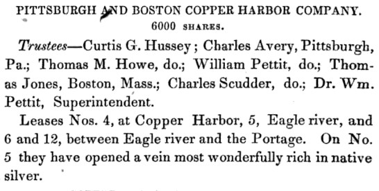
“Pittsburgh and Boston Copper Harbor Company”
~ Reports of Wm. A. Burt and Bela Hubbard, by J. Houghton Jr and T. W. Bristol, 1846, page 92.
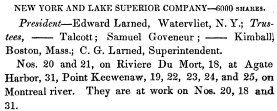
“New York and Lake Superior Company”
~ Reports of Wm. A. Burt and Bela Hubbard, by J. Houghton Jr and T. W. Bristol, 1846, pages 93-94.

“Boston Mining Company”
~ Copper Country Reflections
About four miles southwest from this, the “Pittsburg Company” are working a vein about four feet wide, which bears silver also, but its value is not as well tested as the Lake Superiour Company’s bed. Eagle river is only a brook, coming down from the mountains, which a Ynan may cross by ten steps at low water. The shaft and pounding mill is about one and a half miles from the shore, and their landing is five or six miles east. At Eagle Harbour, they have a saw mill and many buildings. The celebrity of the mines, and the scarcity of places of shelter, have caused a great many persons to visit the spot during the past season. The superintendent and his assistants have, however, always shown visiters that attention and hospitality, which could nowhere be esteemed more highly. About three miles east of Eagle river, is the Henshaw location, not as yet much worked. On the west side of Eagle Harbour, at Sprague’s location, I procured a handsome specimen of silver, which appeared to be abundant. On the east side is the Bailey location, not worked, but which is well spoken of. On Agate Harbour, the “New York and Lake Superiour Company” had sunk three shafts without hitting the metallic vein. The “Boston Company” have an establishment at the east end of the harbour. Within two miles, on the east, there are two veins, from one of which a piece of native copper, weighing about 400 pounds, was taken by Mr. Hempstead, and in the other a valuable sulphuret of copper has since been discovered. A vein of sulphuret is also known on the waters of Mineral creek, a few miles west of the Ontanagon.
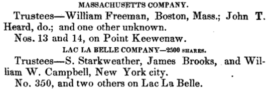
“Massachusetts Company”
~ Reports of Wm. A. Burt and Bela Hubbard, by J. Houghton Jr and T. W. Bristol, 1846, pages 101.
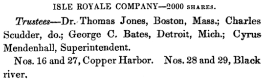
“Isle Royale Company”
~ Reports of Wm. A. Burt and Bela Hubbard, by J. Houghton Jr and T. W. Bristol, 1846, pages 94.
The “Massachusetts Company” have commenced works about a mile west of the extremity of Copper Harbour, where several veins, apparently rich, and said to carry silver, have been opened on the coast. At the Harbour, the “Pittsburgh Company” have two shafts, from which they have taken several tons of the rich black oxyde. A mile east, is a location of the ” Isle Royal Company,” under the charge of Mr. Cyrus Mendenhall, employing ten or fifteen hands.
There are probably now in the country 600 persons engaged in mining, as labourers, agents, clerks, superintendents, and mining engineers.
Communication is kept up with them during the winter, by a semimonthly mail from Green Bay, taken on the back of a man, by way of the Menominee river and the Anse, to the post-office at Fort Wilkins. This does not allow the carriage of newspapers, or heavy packages, but only letters. Although the winter is severe, it is so uniform that those who have tried it do not complain, and even pursue their journeys with more facility by land than they can in summer. If a road were open to Green Bay, the journey would be made in four or five days, over a road which, once trod, would be perfect for several months. From the best information derived from mail carriers, and gentlemen who have made the trip on snow-shoes, it is not an expensive route for a road.
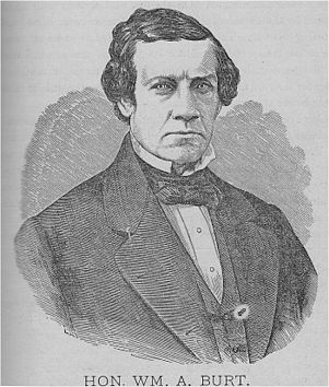
Judge William Austin Burt
~ Wikipedia.org
I have spoken frequently of the fluctuations of the needle, and of its variations. The surveys in this region can be made only with the solar compass, or some instrument of that nature. The one used by Judge Burt, who has run all the township lines west of the Sault, is of his own invention. It is now made in England for exportation to this country. This compass is placed in the meridian by an apparatus always directed on the sun, and as it carries a needle, shows the variation every time it is set.
At the Sault the regular variation was given 2 deg. east, which, at every section corner on the town lines, is written with red chalk on the stake. At southwest corner section 19, range 35 west, T. 55 north, variation 7 deg. 15 min. east; 6 miles directly south, 5 deg. 15 min. east. One mile north of southeast corner of T_ 52 north, range 36 west, variation 5 deg. 5 min.; one mile west, 6 deg. 5 min. At south corner of T. 52, range 37, variation 5 deg. 15 min. east; one mile north, 1 deg. 10 min.; two miles west, 1 deg. 35 min.; three miles further west, 8 deg. 15 min. At middle of south line of T. 51 north, range 40 west, variation 5 deg. 35 min. east.
For game we saw pheasants, or as some call them partridges, in great numbers, and also red squirrels. No turkeys, deer, or black squirrels. There are bears, moose, and reindeer; yet they are not numerous. There is also an animal of the wild-cat species, called a lynx, whose tracks we saw. For reptiles, we saw none but a few feeble garter snakes. There are owls, mice, and rabbits in abundance. We saw no insects of consequence, except spiders, and these were sufficiently numerous to be troublesome. During the latter part of June, and the whole of July, in the woods and low places, there are countless myriads of moschetoes and sand-flies. They are said not to be troublesome on the coast.
Much of the comfort of a trip in this region depends on the outfit. Arrangements should be made for a supply of at least two pounds of solid food per day for each man, and a surplus for friends who are less provident.
The cheapest, least weighty and bulky, as well as the best for health and relish, are hard bread, beans, and salt pork, of the very best quality. Tea, coffee, and sugar, are in such cases not necessaries, but are, for the expense and trouble, the greatest and cheapest luxuries that can be had under any circumstances. To every two men there must be a small camp-kettle, and if in a boat, a large kettle and frying-pan. In the woods, a hatchet to every two men, and a strong tin cup for each, with a surplus of one-half these articles to make up for losses. Knives, forks, and spoons disappear so fast that two setts to each man will be none to many. Salt and pepper are indispensable for the game you may kill; and if there are a plenty of horse-pistols, a great many pheasants may be shot without much loss of time. But these are not to be taken into account for supplies.
A pocket compass is necessary to each party. For a pack there is nothing better than a knapsack and straps, without the boards. Ordinary clothing is of no use, for it will disappear in a short time. The surveyors wear trousers made of heavy cotton ticking, and a sort of pea-jacket made of the same. This or medium cotton duck will stand wear, and although moisture comes through, the rains do not. It thickens when wet, and turns long storms better than any thing except oil-cloth. A supply of thick flannel shirts should be procured without fail, and flannel or Canton flannel under-clothes. A vest is unnecessary, and instead of suspenders the pantaloons are kept up by a broad belt, on which the tin-cup may be strung. A low, round-crowned, white beaver hat is much worn, but perhaps a light cap, of oiled silk, made soft and impervious to rain, is better. For the feet, moccasins or light brogans, made of good leather, and plenty of woollen stockings. In the wet season, cowhide boots, made of good but not heavy leather, and very large, but in the shape of the foot. A flint and steel for emergencies, and matches for ordinary use to strike a fire. Without something water-proof around them, the matches will acquire moisture in long spells of wet weather. If you carry a map case, they may be put in a second case, around which the map is rolled. A belt with a leather pouch and a buckle, to carry the hatchet in, is a very great convenience; for nothing is so likely to be lost as a hatchet. We were three days without one in very bad weather, having dropped it on the route.
Tents are not indispensible, but comfortable, especially along the shore and in very warm weather, when moschetoes are plenty.
A good, large, heavy Mackinaw blanket is beyond comparison the most necessary article to the voyageur and woodsman. With all these preparations, the lover of exercise and adventure may count upon as much enjoyment, on a trip through the Lake Superior country, as he will find at home. If he is badly provided, he will be inefficient and uneasy – will suffer many privations, and perhaps injure his health.
Wisconsin Territory Delegation: La Pointe
April 23, 2016
By Amorin Mello
A curious series of correspondences from “Morgan”
… continued from The Copper Region.

The Daily Union (Washington D.C.)
“Liberty, The Union, And The Constitution.”
August 9, 1845.
La Pointe, Lake Superior
July 26, 1845
To the Editor of the Union:

View of La Pointe, circa 1843.
“American Fur Company with both Mission churches. Sketch purportedly by a Native American youth. Probably an overpainted photographic copy enlargement. Paper on a canvas stretcher.”
~ Wisconsin Historical Society
I have just time to state that, having spent five days at Copper Harbor, examining the copper mine, &c. at that place, and having got everything in readiness, we set off for this place, along the coast, in an open Mackinac boat, travelling by day, and camping out at night. We reached this post on yesterday, the 25th instant. We have now been under tents 21 nights. In coming up the shore of the lake, we on one occasion experienced a tremendous rain accompanied with thunder, which wetted our things to a considerable extent, and partly filled the boat with water.
On our way we spent a good part of a day at Eagle river, and examined the mine in the process of being worked at that place, but found it did not equal our expectations.
We also stopped at the Ontonagon, the mineral region bordering which, some fifteen miles from the lake, promises to be as good as any other portion of the mineral region, if not better.
I have not time at present to enter fully into the results of observations I have made, or to describe the incidents and adventures of the long journey I have performed along the lake shore for the distance of about 500 miles, from Sault Ste. Marie to La Pointe. There are many things I wish to say, and to describe, &c.; but as the schooner “Uncle Tom,” by which I write, is just about leaving, I have not time at present. I must reserve these things for a future opportunity.
I am, very respectfully,
Your obedient servant,
MORGAN.
P.S. – I set off in a day or two for the Mississippi and Falls of St. Anthony, via the Brulé and St. Croix rivers.
Yours, &c., M.
The Daily Union (Washington D.C.)
“Liberty, The Union, And The Constitution.”
August 25, 1845
EDITOR’S CORRESPONDENCE
—
[From our regular Northern correspondant.]
La Pointe, Lake Superior,
July 28, 1845.
Map of the Mineral Lands Upon Lake Superior Ceded to the United States by the Treaty of 1842 With the Chippeway Indians.
~ Wisconsin Historical Society
In what I said in my last letter of this date, in relation to the extent, value, and prospects of the copper-mines opened on Lake Superior, I had no wish to dampen the ardor, would the feelings or injure the interest of any one concerned. My only wish is to state facts. This, in all cases, I feel it my duty to do; although, in so doing, as in the present case, my individual interest suffers thereby. Could I have yielded to the impulses and influences prevailing in the copper region, I might have been greatly benefited in a pecuniary point of view by pursuing a different course ; but, knowing those whom I represented, as well as the public and the press for which I write, wanted the truth, the whole truth, and nothing but the truth, I could do nothing less than make the statement I did. Previous to visiting the country, I could, of course, know nothing of its real character. I had to judge, like others, from published reports of its mineral wealth, accompanied with specimens, &c., which appeared very flattering; but which, I am now convinced, have been rather overdrawn, and the mineral region set out larger and richer than it really is. The authors of the reports were, doubtlessly, actuated by pure motives. They, no doubt, had a wish, in laying down the boundaries of the mineral region, so to extend it as to leave out no knoll or range of trap-rock, or other formation, if any indicative of mineral deposites, which usually appear in connexion with them, occurred.
I consider, in conclusion, that the result thus far is this: that the mines opened may possibly, in their prosecution, lead to rich and permanent veins; and probably pay or yield something, in some cases, while exploring them. But, however rich the specimens of one raised, at present there is nothing in them, geologically speaking, that indicates, conclusively, that they have reached a vein, or that the mines will continue permanently as rich as they are at present. This would be my testimony, according to the best of “my knowledge and belief,” on the witness’s stand, under oath.
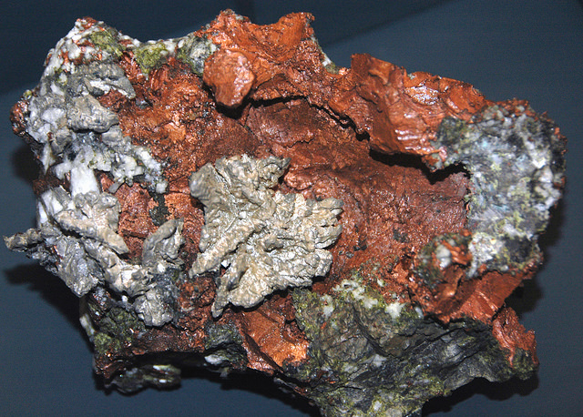
“The remarkable copper-silver ‘halfbreed’ specimen shown above comes from northern Michigan’s Portage Lake Volcanic Series, an extremely thick, Precambrian-aged, flood-basalt deposit that fills up an ancient continental rift valley.”
~ Creative Commons from James St. John
That the region, as before said, is rich in copper and silver ores, cannot be denied. And I think the indications that veins may or do exist somewhere in great richness, are sufficiently evident to justify continued explorations in search of them, by those who have the means and leisure to follow them up for several years. To find the veins, and most permanent deposites, must be the work of time; and as the season is short, on Lake Superior, for such operations, several years may be necessary before a proper and practical examination can be made of the country.
The general features of Lake Superior are very striking, and differ very much in appearance from what I have ever met with in any other part of the continent. The vastness and depth of such a body of pure fresh cold water so far within the continent, is an interesting characteristic. When we consider it is over 900 feet deep, with an area of over 30,000 square miles, and yet that, throughout its whole extent, it presents as pure and as fresh-tasted water as though it were taken from a mountain brook, the question naturally arises, Where can such a vast supply of pure water come from? It is true, it has great many streams flowing into it, but they are nearly all quite small, and would seem to be wholly inadequate to supply such a vast mass of water, and preserve it in such a state of purity. The water supplied by most of the rivers is far less pure than that in the lake itself. East of Keweena point, we found the water of the rivers discolored, being tinged by pine and other roots, clay, &c., often resembling the hue of New England rum. Such rivers, or all combined, would seem to be inadequate to supply such a vast quantity of pure clear water as fills this inland ocean!
~ United States Geological Survey
It is possible that this great lake is freely supplied with water from subterranean springs opening into it from below. The river St. Mary’s also seems inadequate, from its size, to discharge as much water as comes into the lake from the rivers which it receives. In this case, evaporation may be so great as to diminish the water that would otherwise pass out at it.
As relates to tides in the other lakes, we have nothing to say; but, as far as Lake Superior is concerned, we feel assured, from observation, as well as from the reports of others upon whom we can rely, that there are tides in it – variously estimated at from 8 to 12 inches; influenced, we imagine, by the point of observation, and the season of the year at which such tides are noticed.
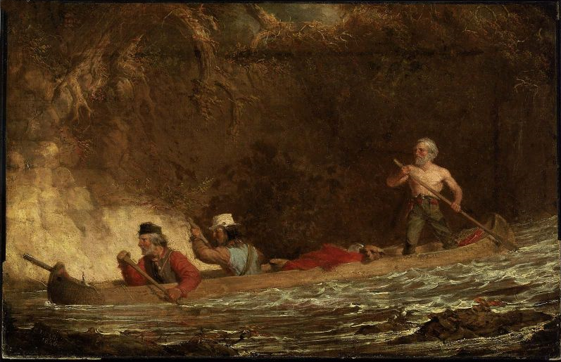
The Voyageurs (1846) by Charles Deas.
~ Commons.Wikimedia.org
What strikes the voyageur with the most interest, in the way of scenery, is the wild, high, bold, and precipitous coast of the southern shore, for such much of the whole distance between Grand Sable and La Pointe, and, indeed, for some distance beyond La Pointe ; the picturesque appearance of which often seemed heightened to us, as on a clear morning, or late afternoon, or voyageurs would conduct our boat for miles near their bases. Above us, the cliffs would rise in towering heights, while the bald eagle would be soaring in grand circular flights above their summits; our voyageurs, at the same time, chanting in chorus many of their wildest boat songs, as we glided along on the smooth and silent bosom of the lake. I have heard songs among various nations, and in various parts of the world; but, whether it was the wild scenery resting in solemn grandeur before me, with the ocean-like waste of water around us, which lent wilderness to the song, I never listened to any which appeared to sing a verse in solo, and then repeat a chorus, in which the whole crew would join. This would often be continued for several miles at a time, as the boat glided forward over smooth water, or danced along over the gentle swells of a moderate sea; the voyageurs, at the same moment, keeping time with their oars.
Jean Baptiste, our pilot, had an excellent voice, full, loud, and strong. He generally led off, in singing; the others falling in at the choruses. All their songs were in French, sometimes sentimental or pathetic, sometimes comic, and occasionally extempore, made, as sung, from the occurrences of the preceding day, or suggested by passing scenes.
The Chippewa Indians are poor singers; yet they have songs (such as they are) among them; one of which is a monotonous air repeated at their moccasin games.
Stereographic view of a moccasin game, by J. H. Hamilton, 1880.
~ University of Minnesota Duluth
Next to the love of liquor, many of the Indians have a most unconquerable passion for gambling. While at La Pointe, I had an opportunity of seeing them play their celebrated moccasin game. They were to the number of two, or three aside, seated on the ground opposite to each other, which a blanket spread out between them, on which were placed four or five moccasins. The had two lead bullets, one of which was made rough, while the other remained smooth. Two f the gamesters were quite young men, with their faces painted with broad horizontal red and blue stripes, their eyelashes at the same time being dyed of a dark color. They played the game, won and lost, with as much sang froid as old and experienced gamblers. Those who sat opposite, especially one of them, was much older, but no means a match, at the time of my visit, for the young rascals, his antagonists. One takes the balls in his hands, keeps his eye directly on the countenance of the opposite party, at the same time tossing the balls in his hands, and singing, in a changing voice, words which sound somewhat like “He-he-hy-er-he-he-hy-er-haw-haw-haw-yer. He-he-hy-er,” &c. During which he keeps raising, shifting, and putting down the moccasins, till, finally, he raises his hands, having succeeded in concealing the balls under two of the moccasins, for which the other proceeds to search; and if he succeeds, on the first trial, in finding the rough ball, he wins. Then he takes the balls to hide, and commences singing himself. If he fails, he loses; and the first party repeats the song and the secretion of the balls. They hold in their hands small bundles of splinters of wood. When one loses, he gives to the winner so many sticks of wood. A certain number of them gained by any one of the party, wins the game. When I saw them, they had staked up their beads, belts, garters, knife-cases, &c. Their love of gaming is so strong, as to cause them to bet and lose everything they possess in the world – often stripping the last blanket from their naked backs, to stake on the game. It is said that some Indians acquire so much dexterity at this game, that others addicted to it refuse to play with them. In playing the game, they keep up a close watch on each other’s eyes, as being the best index to the movement of the hands. The song is repeated, no doubt, to diver the attention of the antagonists.
Among other peculiarities of Lake Superior, and one of its greatest recommendations, is the abundance and superiority of its fish, consisting of trout of large size, white fish, siskomit, ( a species of salmon,) and bass. The trout and siskomit are the finest and noblest fresh-water fish I ever saw. Almost every day we could catch trout by trailing a hook and line in the water behind out boat. In this way we caught one fine siskomit. Its meat, when fresh-cooked, we found about the color of salmon. The fish itself is about as heavy as a common-sized salmon, but less flat, being more round in form.

Detail of “The 12 Apostles” from Captain Jonathan Carver’s journal of his travels with maps and drawings, 1766.
~ Boston Public Library
If you will look at a map of Lake Superior, you will find, near its upper end, a labyrinth of islands, called by the early French voyageurs, of whom P. Charlevoix was one, (a Jesuit,) “the Madelaine islands.” They are sometimes called “the Twelve Apostles.” The largest island is now generally known as “the Madelaine island” – being the largest of the group. Just inside, and near its southern extremity, at the head of a large, regular bay, with a sandy beach, with an open and gently-rising scattered pine and spruce land in the rear of the beach, stands La Pointe – one of the most pleasant, beautiful, and desirable places for a residence on Lake Superior, and the very place where Fort Wilkins should have been placed, instead of its present location, which must be conceded, by every impartial person, to be among the very worst that could have been selected on the whole lake.
The garrison at Copper harbor, located, as it is, upon the rocky surface of trap conglomerate, affording a surface so scantily supplied with soil amidst masses of pebbly rock and trap fragments as to be wholly unfit for any sort of cultivation whatever, is altogether out of place. It is wholly inaccessible by land, and can only be reached by water in summer. It is at a spot where Indians usually never passed within forty miles of it, till since its occupation.
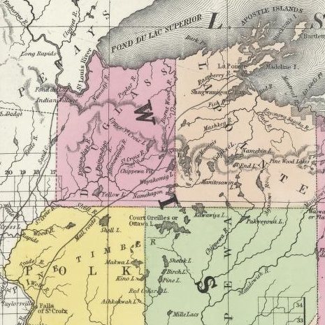
Detail of the Indian trail or “mail route” between La Pointe and St. Anthony Falls.
~ A new map of the State of Wisconsin, by Thomas, Cowperthwait & Co., 1850
The very next Congress should direct its prompt removal to La Pointe. Here, from the foot of the bay in front of the Madelaine island, there is an Indian trail, connecting La Pointe with St. Anthony’s Falls, and over which the mail is carried in winter by voyageurs on foot. La Pointe is the favorite resort of the Indians. Their lodges, in villages, bark canoes, &c. are found here the year round.
They delight to paddle and sail their canoes about the beautiful bays, harbors, &c. of these islands, employing their time in canoe building, hunting, fishing, &c. At every annual payment of their annuities, they flock to La Pointe in great numbers. Not only is that section of the great Chippewa nation sharing in the annuities brought together, but large parties of the same tribe, who receive no annuity, come at the same time from the British possessions to the north of Pigeon river. The Chippewas, called the “Pillageurs,” (so called from their thievish propensities,) inhabiting the country about Mille and Leech lakes, also attend – to meet relations, to traffic , and, perhaps, to steal a little. The great advantage of a government outpost is felt in the moral effect it exercises over the Indians. I know of no place where this influence would be more decidedly and beneficially exerted than at La Pointe. here should be daily unfurled the “stars and stripes,” and the sound of the evening gun be heard over the beautiful bays, and along the shores of the Twelve Apostles, which the Indians would learn to reverence with little less respect than they do the voice of the Manitou – the guardian spirit of the mines, embowelled in the dark trap hills of the lake.
Here, too, is an exceedingly healthy place, a good soil, and every convenience for raising the finest potatoes, turnips, and every kind of garden stuff.

1856 oil painting of Doctor Charles William Wulff Borup, a native of Copenhagen, Denmark. Borup married Elizabeth Beaulieu, a Lake Superior Chippewa daughter of Bazil Hudon Beaulieu and Ogimaagizzhigokwe. Borup and his brothers-in-law Charles Henry Oakes and Clement Hudon Beaulieu were co-signers of the 1842 Treaty with the Chippewa at La Pointe. Borup and Oakes became the first bankers of Minnesota.
Dr. Borup, the agent for the American Fur Company, (who have an extensive trading-post at this place,) has a superb garden. In walking through it with him, I saw very fine crops of the usual garden vegetables growing in it. His red currant bushes were literally bent down beneath their weight of ripe fruit. His cherry-trees had also borne well. Gooseberries also succeed well. The doctor also had some young apple-trees, that were in a thriving condition. Poultry, likewise, does well. Mrs. B. had her yard well stocked with turkeys, geese, ducks, and chickens. There was also a good garden at the mission-house of the American board.
However infinitely better is such a place for a United States garrison than Copper harbor, located, as it were, on a barren rock, where no Indians are seen, unless induced to go there by the whites – where there is nothing to protect – where intercourse is cut off in winter, and food can only reach it in summer – where there is no soil on which to raise a potato or a cabbage. I can only say that a greater blunder, in the location of a military post, was probably never committed. And if made (of which I am assured it was not) by a military man, he ought to be court-martialed and cashiered.
The mouth of the Ontonagon river is a far better spot for the fort than Copper harbor. It has a good soil, and a beautiful site for a fort. Furthermore, the country between it and Fort Winnebago, on the Wisconsin river, is favorable to the construction of a military road, which ought, at no distant day, to be opened. Another road should be cut from Fort Snelling, near the falls of St. Anthony, to La Pointe. In cutting these roads, it would seem to me as if the United States soldiers themselves might be usefully employed.
~ FortWiki.com
While at Copper harbor, I frequently visited Fort Wilkins, in command of Captain Cleary, whom I consider in every way an ornament and an honor to the service. In the brief space of time he has been at this post, and with the slender materials at command afforded by the country, he has nevertheless succeeded in making an “oasis” in a wilderness. He has erected one of the neatest, most comfortable, and best-planned garrisons it has been my lot to enter on the western frontier. He keeps all in excellent condition. His men look clean, healthy, and active. He drills them daily, and keeps them under most excellent discipline. He seems to take both pleasure and ride in the service. He says he never has any difficulty with is soldiers while he can exclude ardent spirits from them, as he succeeds in doing here, notwithstanding the great number of visitors to Copper harbor this summer.
To all travellers who are interested in objects of leading curiosity, the character of the Indians they fall in with cannot fail to arrest a share of attention.
The Chippewas are the only Indians now met with from the Sault Ste. Marie and Mackinac, extending from thence west along the southern shore of Lake Superior, to Fond du Lac, and from thence, in the same direction, to the Mississippi river. Within the United States they extend over the country south from the British boundary, to the country low down on the St. Croix and Chippewa rivers. The same tribe extends from our boundary northwest of the lake, entirely around its northern shore on British territory, till they reach the Sault Ste. Marie, opposite the American shore. It is said this tribe, spread over such a vast tract of country, is a branch of the powerful race of the Algonquins. They are sometimes called O-jib-was. They do not exist as a consolidated nation, or strictly as a confederation of bands. The entire nation on both sides of the line is divided into a great number of bands, with a chief at the head of each, which not uncommonly go by his name, such as “Old Martin’s band,” “Hole in the Day’s band,” &c.
The chief’s son, especially if he exhibits the right qualities, is expected to succeed his father at the head of the band; but very frequently the honor is reached by usurpation. The whole nation, which widely differ in circumstances, according to the part of the country they inhabit, nevertheless all speak the Chippewa language, and have extensive connexion by marriage, &c. The bands inhabiting the southern shore of Lake Superior are by far the best of any others. Though polygamy still prevails among them, and especially among their chiefs, it is nevertheless said to be becoming less common, especially where they are much influenced by Catholic and other missions. While at La Pointe, an Indian wedding was consummated, being conducted according to the ceremonies of the Catholic church, and performed by the missionary priest of that persuasion stationed at the Pointe.
There is one trait of character possessed by the Chippewas, (if we except, perhaps, the band of “pillageurs,” who have a kind of “Bedouin Arab” reputation among their countrymen,) which, I am sorry to say, the whites do not possess in an equal degree – that is, “very great honesty.”
White men can travel among them with the most perfect safety as to life and property. I will venture to say, that a man may carry baskets filled with gold and silver, and set them down in Indian villages, or leave them lying where he likes, or go to sleep by them, with Indians encamped all around him, and not one cent will be touched. Such a thing as a house being broken open and robbed at a Chippewa Indian trading-post was never heard of – within between two and three years’ intercourse with them – in time of peace. Dr. Borup said he would not be afraid, if concealed to look on, to leave his store door open all night; and the fact alone of its being left open, might be made known to the Indians at the Pointe. He would expect to see no Indian enter the store, nor would he expect to lose anything; such was his confidence in their honesty!!
Last winter, flour at the Pointe rose to $40 per barrel. The poor Indians were nearly famished for bread, but were unable to purchase it at such a price. They knew the American Fur Company had a considerable lot in store, guarded by nothing stronger than a padlock, yet they never offered the least violence towards the company’s agents or store! Would white people have acted as honestly? The poor Indians, by nature honest, have too often known the whites by the wrongs inflicted upon them, which God can forgive, but time can never blot out! They are very superstitious, but not as basely and insanely so, but a great deal, as the Mormons, Millerites, and other moon-stricken sects among the whites. They believe in one Great and Good Spirit, or a Being who can at will inflict good or evil on mankind; and there’s an end of it. They often denominate the mysterious spirit of evil import the Manitou, making him to dwell in the wild hills, islands, grottoes, and caves of Lake Superior.
From these huge birds the Indians obtained their first knowledge of fire, which they kindled with fire-sticks. These mythical birds were the most powerful of the animal deities of the Indians of the woodlands and of the plains. When the weather was stormy they flew about high in the heavens. When they flapped their great wings, one heard the crashes of thunder, when they opened and closed their eyes flashes of lightning were seen. Some carried lakes of water on their backs, these slopped over and caused downpours of rain. Their arrows, or thunderbolts, were the eggs which they dropped in their flight. These shattered the rocks and set fire to the forests and prairies.
A Chippewa Indian hunter, who was carried away to his nest by a Thunderer, saved his life by killing one of the young birds and flying back to earth in its feathered hide.
In the Smoky Mountains, a wild and rugged region in the southwestern part of Bayfield County, was the home of Winneboujou (Nenebozho), the fabled hero of the Ojibwa Indians. This all-powerful manitou was a blacksmith, and had his forge on the flat top of the highest mountain. Here he shaped the native copper of the Lake Superior region into useful implements for his Indian children. Much of his work at his forge was done at night, and the ringing blows of his great hammer could be heard throughout the Brule Valley and Lake Superior region. The fire of his forge reddened the sky. When he was not busy at his forge he was away hunting or seeking other adventures. Many stories of the exploits of this giant manitou have been told by the Chippewa and other Wisconsin Algonquian tribes.”
~ Legends of the Hills of Wisconsin by Dorothy Moulding Brown; The Wisconsin Archaeologist, Volume 18, Number 1, 1937, pages 20-21.
At times, it is said, a peculiar noise issues from the Porcupine mountains, and from the high hills on the main land, both east and west of La Pointe, some distance off. It is said to resemble the distant discharge of ordnance, or thunder. At one time, they said it was so loud and frequent, that they mistook it for signal guns fired from the brig Astor, which they thought might be in distress, and actually sent out a boat in search of her.
“Ojibwe shoulder pouch depicting two thunderbirds in quillwork, Peabody Museum, Harvard University.”
~ Commons.Wikimedia.org
These sounds the Indians believe to be the voice of the spirit “Manitou,” who guards the deposites of mineral wealth embowelled beneath the hills, and to whom any attempt made to dig them up, and carry them off, would be highly offensive, and followed by some kind of punishment. I have never yet heard of an Indian’s leading a white man to a locality of copper, or telling where he has found a piece when picked up!
Some have supposed that the noise in question arises from volcanic action; but, as no vibration is felt in the earth, and no other proof exists of such being the case, we are led to believe that the noise is produced by the lashing of the waves of the lake after a storm, as they are driven forward into the grottoes, caves, &c. of the tall sandstone cliffs, formed at their bases by the disintegrating effects of water and ice. Some distance east of La Pointe, about the Little Girl’s Point and Montreal river, as well as west of the same place, some fifteen or twenty miles, high red sandstone cliffs occur. At their bases, near the water’s edge, a great many curiously-shaped caves and grottoes appeared. In places, the sandstone had been so cut away, that only pillars remained standing at some ten or fifteen feet in the lake, from the top of which a high rude arch would extend to the main shore, and beneath which boats could easily pass. This was particularly the case near where the islands are parted with going west up the southern shore of the lake. Some caves, with small openings for mouths, run for a long distance back beneath the hills, expanding, likely, into large halls with high vaulted roofs, &c. After a storm, a heavy sea continues to roll into these grottoes and caverns, the waves lashing themselves against their sides and roofs – thus producing sounds resembling those heard at La Pointe, &c.
As the weather is generally calm after a storm, before the sea goes down, it is likely at such times these sounds are heard.
We had occasion to pass these places when a considerable sea would be on, close to the cliffs, and could hear the hollow heavy sounds of the waves as they broke into the caverns within the cliffs and hills. Every day, while we remained, parties of Indians continued to arrive, to be present at the payment.
We finally became prepared to leave for the Mississippi, having bought two bark canoes, and hired four new voyageurs – two for each canoe – one Indian, one half-breed, and two descendants of Canadian French; and, with a stock of provisions, we were ready to be off. From this place, I sent back three voyageurs to the Sault Ste. Marie, all that I hired to come as far as La Pointe. So, after paying our respects to Mr. Hays, our worthy Indian agent, and to Dr. Borup, (to both of whom I had borne letters of introduction,) and having many “bon voyages” heaped upon us by our friends and the friends of the voyageurs, we bade adieu to La Pointe.
You will not hear from me again till I reach the Falls of St. Croix.
I am yours, very truly, &c.
MORGAN.
To be continued in Saint Croix Falls…
By Amorin Mello
A curious series of correspondences from “Morgan”
… continued from To The Far West.
The Daily Union (Washington D.C.)
“Liberty, The Union, And The Constitution.”
July 7, 1845.
MADISON, (W.T.,) June 26, 1845.
To the Editor of the Union:
SIR: Our democratic territorial convention has this day nominated the Hon. Morgan L. Martin, of the county of Brown, as the candidate for the delegacy, to succeed Governor Dodge. Mr. Martin is one of our ablest and most reliable democrats, and there is but little doubt of his election by a triumphant majority. Mr. Martin has been fourteen years in the upper branch of our territorial legislature, and has been the presiding officer of that body at four sessions. The democrats of the Territory will go into the canvass in the best possible spirits, and with the fullest confidence of success; for they are well united, and have a candidate worthy of the cause and their most zealous support.
Henry Dodge
~ Wikipedia.org
More than twice the number of immigrants are arriving here daily, this season, than have ever come at any previous season. The administration of Governor Dodge is very popular with all parties, and so are the measures of the national administration, and particularly its course on those two great questions – the annexation of Texas, and the maintenance of our rights to Oregon.
The convention was very fully attended; and, although there was some division when it assembled, as to who the nominee should be, the members left here in the best possible spirits. In haste.
Yours, truly,
J. A. N.

The Daily Union (Washington D.C.)
“Liberty, The Union, And The Constitution.”
July 8, 1845.
[From our regular correspondent.]
MACKINAC, June 29, 1845.
This small town stands on a narrow slip of land sloping from the foot of elevated bluff hills in the rear, to the water. The second and highest elevation is about three-quarters of a mile in the rear of the town, and is three hundred feet above the level of the lake or straits, and nine hundred feet above the level of the ocean. The site of the town winds in a crescent form around a small harbor, indented in the southeastern part of the island.

Painting of Fort Mackinac by Seth Eastman in 1761.
~ United States Army Center of Military History
The old Fort Mackinac stood on an extreme northern point, putting out into the strait from the southern main land, some 10 or 15 miles to the southward of this place. It was first settled upon as a French missionary station, and a fort erected. When Carver visited it in 1756-’57, the fort was garrisoned by the English, who came into possession of it with the conquest of Canada, a few years before. It then contained 30 houses, and had one hundred men in garrison, besides a government-house, &c. In 1763, the various northwestern tribes of Indians who had long known the French as the first Europeans they had ever formed friendly intercourse with, became highly dissatisfied with the change from French to English rule. A powerful league was, therefore, formed between the Ottowas, Chippewas, the Hurons, Menomonees, &c.; and the celebrated Pontiac was their leader, who bore a deadly hostility to the English.
!["No authentic images of Pontiac [also known as Obwandiyag] are known to exist. This interpretation was painted by John Mix Stanley." ~ Wikipedia.org](https://chequamegonhistory.com/wp-content/uploads/2016/04/pontiac-chief-artist-impression-414px.jpg)
“No authentic images of Pontiac [also known as Obwandiyag] are known to exist. This interpretation was painted by John Mix Stanley.”
~ Wikipedia.org
After peace was made with Pontiac, the fort came again into the occupancy of the English, who transferred it to us, under the treaty of peace, at the close of the revolutionary war. When the late war broke out, the British took both old Fort Mackinac and the fort at this town, and held them up to the treaty of Ghent; and if war were to begin soon, they would inevitably fall into their hands again, owing to our neglect to fortify them in a proper manner. The old site we have abandoned, and erected a small and well-built fort on the hill, just in the rear of the town, on the island, which is about one hundred and fifty feet high above the level of the lake, or strait. About three-quarters of a mile behind the fort, there is a high hill – the highest on the island – with its steep face looking towards the fort and harbor, while its eastern and northern section extends over a narrow plateau, or level, which could be completely raked by guns stationed on the walls of a fort, which should, by all means, be erected near the brow of the hill. This high point of land overlooks and completely commands the fort our troops (two companies) at present occupy.
“Major Charles Gratiot visited Mackinac Island in 1817, using his trained engineer’s eye to carefully record the design of Fort Holmes in these detailed plans. The fort’s blockhouse, walls, and gun platforms are clearly visible on Gratiot’s drawings”
~ Mackinac State Historic Parks
The first news the people heard of the declaration of war in 1812 in Mackinac, was the appearance of a large body of English and Indians on the high hill, who commanded the surrender of the fort, then garrisoned by some fifty or sixty men which was complied with. The English entrenched this high ground, planted some batteries on its ramparts, and named it “Fort Holmes,” which it still bears.
This point is the main key to those important straits which connect two of the great lakes. It is now just in the state of ruins in which the British left it in 1814-’15; and why our government have not strongly fortified it, seems inexplicable. If this hill were strongly fortified, with armed outposts at some other points about the straits, the military defences of this place would be wholly impregnable – even stronger, if anything, than the rock of Gibraltar. The position is a most important one and government should lose no time in putting it in a complete state of defence.
The only communication by water, between the two great lakes of Michigan and Huron, is directly in view of the heights of this harbor.
From the hill of Fort Holmes, there is a most magnificent view. The great sheets of water in the straits, with the islands, distant main-land, &c., are all in full view. The approach of a steamer or vessel can be seen when from twelve to fifteen miles distant, in the eastern or western offing.
This post was first settled in 1764 – the year after the fall of old Mackinac. In 1796 it was conveyed by the English to St. Clair. It has long been a celebrated Indian trading-point, and is so yet; large numbers of whom constantly visit the place in the birch-bark canoes, encamping beneath bark wigwams (or shanties) on the stony beach along the shore.
1843 Drawing of Mission Point Beach at Mackinac Island, Michigan
~ Historic Mackinac, Volume 1, facing-page 367.
This is also a great point for catching lake trout, or salmon-trout, white fish, &c., which are salted down in barrels, and shipped to market, selling for about seven dollars per barrel, on average. This business is in the hands of Indians, half-breed Indians, and French fishermen, who go out into the lakes in Mackinac boats, properly prepared with seines, hooks, &c.

Photograph of Arch Rock on Mackinac Island, by n8huckins, shared under Creative Commons.
~ Wikipedia.org
The island of Mackinac is about 9 miles in circumference, and contains several natural curiosities among which, is the Giant’s Arch, or Rock, about a mile northeast of the town. It is 100 feet high – the natural arch having a span of 45 feet wide.
Nearer the centre of the island is Henry’s cave, at which, it is said, this traveller once saved his life from the fury of drunken Indians, by secreting himself in it. It was then full of bones, which have since disappeared.
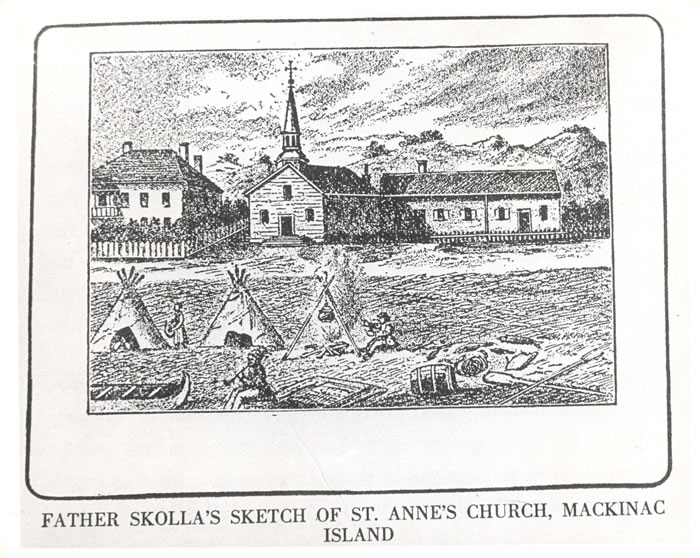
In the town of Mackinac, there are two small churches, the most ancient of which is a Catholic chapel, connected with a Catholic mission at the point. The other is a small Protestant church, originally built in connexion with an extensive mission-house founded by the Presbyterian Board of Foreign Missions. They have since changed the establishment to the shores of Lake Superior. The mission-house is now occupied by Mr. Herrick, lately from Detroit, who has converted it into a large and commodious tavern, at which we are staying. There is also another comfortable hotel in the place.
I know of no place on the continent that can make a more delightful summer residence than Mackinac. The heat of the summer is scarcely felt here at all. You can sleep under a blanket every night throughout the summer.
The drinking water is equal to, if not better than, any which ever gushed from the hill-sides of the Alleghany mountains. The fish are abundant and delicious. Large steamers running between Buffalo and Chicago pass twice daily, touching in each case.
The American Fur Company have an agent here. The United States government have an Indian sub-agent, also resident at this place.
I went to a small Catholic church to-day, where I heard a short sermon in French. The auditory consisted of French descendants, Indians, half-breeds, and some few Americans.
This island is called the county of Mackinac and Sate of Michigan. I believe, in addition to a State court, the United States district judge occasionally holds a court here.
We leave to-morrow, on the steamboat General Scott, expected up to-night from Green bay, for the Sault de Ste. Marie – the place of rendezvous for persons bound up Lake Superior, on which then is no craft at present, except two or three schooners sailing up the lake from the Sault to Copper Harbor, &c.
When I arrive at the Sault (pronounced Soo) Ste. Marie, I will write you again.
I remain yours, very respectfully.
MORGAN.
The Daily Union (Washington D.C.)
“Liberty, The Union, And The Constitution.”
July 16, 1845.
EDITOR’S CORRESPONDENCE.
—
[From our regular correspondent.]
SAULT STE. MARIE,
Near Lake Superior, July 2, 1845.
We left Mackinaw yesterday, the 1st July, about a quarter-past eight , a.m.; our course for forty miles to the “detour” lying through the open and upper part of Lake Huron, which exposed our little boat to a very heavy rolling sea- the result of the previous day or two’s severe blow on the lakes. Many of the passengers, as usual on such occasions, became severely sea-sick. At half-past 12, p.m., we rounded into St. Mary’s river, where we had smoother water.

“A painting by Paul Kane depicts an encampment on the shores of Lake Huron in about 1845.”
~ The Granger Collection, New York
The river at first appeared very wide, with a low and sandy beach on each side, and a flat swampy country running back into the interior. As we progressed, however, the stream grew more narrow, and again expanded into two smart lakes – the first called Great George, and the latter Little George’s lake. Leaving these lakes, the river fifteen or twenty miles below the Sault again contracted, and turned about among high hills a little distance off, while its margin was skirted with low, falt, gravelly ground, covered with white cedar and other rather dwarfed forest trees. These highlands showed steep hills or knobs of old red sandstone.
It was not long after passing the hills, before we hove in sight of the white and frothy rapids, at the foot of which stands the small village of the Sault, at the principal pier of which we landed – it being 60 miles from the lake.
The town exhibits a collection of wooden log-houses, roofed and weather-boarded with birch bark, gathered along the river at the foot of the falls, here and there showing small framed painted houses, one of which is an hotel, at present overflowing with people bound for the mineral lands of Lake Superior.
The Sault contains, besides the houses noticed, a small United States garrison; the slender wooden stockade defences of which, with officers’ quarters, are almost in a state of dilapidation. There is also a small missionary station and school-house belonging to the Methodists, and a U. S. Indian agency.
A painting of an Ojibwa village near Sault Ste Marie; also by Paul Kane in 1845.
~ Wikipedia.org
There is a collector of the port on each side of the river, which is here about a mile wide, between us and Canada. I imagine there is very little business to do by either functionary. The American Fur Company have a station at the Sault. The Hudson Bay Company have a factory, or station, on the opposite side of the river. I paid a visit to the latter yesterday, having a note of introduction to a Mr. Blenden, their agent, whom I found busy in packing up for a voyage up the Canada side of Lake Superior. He is bound on a tour among the posts towards Hudson’s Bay to the north. Mr. B. received me very politely. He informed me that he intended to carry his children with him, whom he expected to send in the care of friends across to Hudson’s Bay, where they would embark on one of the company’s ships for London, and be from thence conveyed to Edinburgh, to be placed at school. He told me Sir George Simpson, the governor of the company, had passed up the lake not long since, accompanied by his boats, &c. he was bound for the valley of the Red river of the North, where he expected to meet a kind of convention of the authorities of the company’s territories in that quarter – among whom would be the representatives of Selkirk’s colony, the population of which is about 5,000. They produce more grain, &c., than they can find means of having conveyed to market: hence there is some emigration from their colony to the valley of the Mississippi, within the States.
Mr. B. states that the Hudson Bay Company employ about seven ships in their trade – two or three of which, every summer, visit Hudson’s Bay; three double Cape Horn, and ascent the Columbia river; and one or two others are employed at other points. He states that their charter gives them ample territorial jurisdiction over all the lands, mines, &c., on the high lands to the north and west of Lake Superior, but not over the lands immediately along the shore. He states that a geologist, Dr. Logan, is engaged in surveying the country of Upper Canada, and is now employed between Lake Ontario and Lake Huron, or the inlet of the latter lake, called Lake Georgina Bay. He is expected up this summer, to examine the northern shore of Lake Superior, which is supposed to be as rich in copper ore, at certain points, as the southern shore.
The two fur companies (American and Hudson Bay) are on the best possible understanding; which has a very favorable influence on the northwestern tribe of Indians.
In 1830, they mutually agreed to exclude all intoxicating drinks, in their traffic and intercourse, from them. The Indians, in consequence of this wise and humane compact, are everywhere, within their bounds more inoffensive and peaceable. It is just as safe, if not more so, to travel among them, than among the whites. They have a considerable number of birch-bark lodges at the Sault, employing their time in catching fish at the foot of the falls, in their gill-nets. They belong almost exclusively to the Chippewa tribe. The Sault is the greatest place for catching fish I ever saw. They can take ten times as many white fish, salmon-trout, brook-trout, bass, &c., as can be disposed of. The Indians push their canoes up into the foam of the falls, cast forward their nets, and draw it as the current carries the boat down again. Our staple article of food at the Sault is fresh fish.
The falls here, or rapids, have only a descent of about 18 to 21 feet in a mile; while the ground is very favorable to the construction of a ship-canal – the length of which need only be a mile. On the Canada side, the length of the rapids is only about three-quarters of a mile long. It is very likely, if our government refuses to construct a canal on our side, that the English may, ere long, make one on their side; which will be only three-quarters of a mile long.

“Hudson Bay Fort, Sault Ste. Marie. By J.S. Hallam.”
~ Sault Ste. Marie Public Library
The fort at this place, in time of war, should be erected on a considerable hill, about three-quarters of a mile in the rear of the Sault, called Coal-pit hill; which commands a fine view of the falls, river, &c.
There are several schooners (say three or four) on Lake Superior, plying between the head of the falls and Lapointe, Copper Harbor, &c. They have been drawn around the falls on rollers. There is some talk of having a steamer carried around by the same means. A fine new vessel is on the stocks at the head of the falls, which is about half done. It will be launched about the 1st of August. She is building by Newbury & Co.; to be rigged as a fore-and-aft schooner.
At the Sault, a Catholic station was founded from one to two centuries ago, being fixed upon as a missionary station. next to Quebec and Montreal, it is said to be the oldest point settled upon by Europeans in Canada. It has always been an important point for the Indian trade. Here goods are carried round the falls, and sent up Lake Superior to be distributed to various Indian trading-posts, far in the northwestern region of the continent.
The early Catholic Jesuits, or priests, who first explored the far distant, cold, and deary regions bordering the shores and streams of the upper lakes, must have been animated with a deal of perseverance, and influenced by the dictates (to them) of an all-powerful religion. They at every prominent point throughout this vast country erected the cross among the savage tribes, and impressed their minds with the solemn and imposing ceremonies of the religion they professed. Their success among the savage tribes of North America has never been surpassed, if equalled, by more modern and persevering denominations. They acquired an influence over the Indians, which nearly a century of British and American domination has not been sufficeint to efface. Even at this day, the frail wooden cross seen standing in the humble grave-yards of the Indians, sufficiently attests the remaining influence of the Catholic religion. French and Indian have also intermarried more than the Anglo-Saxon and Indian. The latter also more commonly speak French. Indians never, in early times, fought Frenchmen. Our earliest accounts of the vast interior western and northwester regions of this continent were derived from Catholic priests, such as Father Hennespin, &c.
The first Englishmen who explored the upper lakes after the fall of Canada, were Henry and Carver, between the years 1766 and 1775-’76. Their works contain many interesting details relative to the country.
In alluding, in a former letter, to our loss of Hunters’ island by the treaty of Washington, I underrated its size. It is greater in area than the vaunted Isle Royale; being about 50 miles long, instead of 40, and about 40 wide.
A gross error prevails with regard to Isle Royale. It is supposed by some that we acquired it by the Lake Washington treaty, when it has always been ours, since the treaty of peace after the revolution. We have, therefore, given away important territory on Pigeon river, without receiving any equivalent, that I know of.
We have been wind-bound at the Sault for two or three days, by reason of a strong northwester, blowing directly down the river. It has been blowing about a half a gale on the upper lakes for nearly two months past; and, from all indications, the gale may last all summer. The weather in this latitude 46 degrees 30 minutes) is very cold. We have to wear thick woollens and sleep under blankets – it being difficult, on the 2d day of July, 1845, to keep warm at that! The soil produces fine Irish potatoes – better than I have tasted anywhere else – some oats, barley, turnips, rye, and wheat, &c. The soil is miserably bad, back in the interior. The population depends chiefly upon fishing, for a support; which, to all appearance, is a never-failing resource.
From this point, I expect to coast the southern lake shore in an open boat, with five or six “voyageurs;” or send them on, and go up to Copper Harbor in the schooner Swallow.
I shall pass to where mail facilities cease, and where the reduction of postage affords no benefit; and it may be some days before you can get another letter from me.
During the late war, the Americans, under command of Major Holmes, burnt down the Hudson Bay Company’s fur agency, or factor, on the opposite site of the river.
Almost the only tribe of Indians visiting or living about the Sault, belong to the Chippewa tribe – which, on the average, are good-locking Indians, and apparently comfortably clad, &c. Many of the half-breeds are really beautiful; and, in regularity of features, figure, and size of hands and feet, would do credit to more civilized life. They seem to me to be more industrious than more southern tribes of Indians among whom I have travelled, and far more inoffensive and civil to the whites. Some of the men are exceedingly tall and fine-looking fellows. I saw yesterday the son of a chief from the Canada side, who stood between six and seven feet high, and was as straight as an arrow. He could not speak a syllable of English. I saw him examining, with much attention, the new schooner building at the head of the falls.

The USS Michigan was launched in 1843, and later renamed as the USS Wolverine in 1905.
~ Wikipedia.org
The names of Indians are often very curious, and, in a measure, put at defiance the power of the English language to express them. I saw a tall man of the Chippewas at Mackinac, as he stood gazing at the United States steamship Michigan. Mr. Biddle, an old resident trader of the place, who spoke Chippewa, was standing near him. he wished to know of Mr. Biddle what sort of a vessel she was; who explained to him that she belong to “his great father, the President, who, if necessary, would use it against his enemies.” This Indian’s name, translated into English, was nothing less than “A Corpse,” or “A Dead Man” – an unusual name, I should think, even for an Indian!
The Indians always keep an abundant supply of dogs, which, about the Sault, seem uniformly to be a cross of the common cur with the wolf, and seem of little use, except to keep up an eternal barking at night about their bark lodges. This is a remarkably fine climate for the Newfoundland dog, some fine specimens of which I have seen in the possession of the whites about the Sault. At Mackinac, and other places in the northwest, the half-breeds especially make draught animals of dogs, in drawing water on trucks, and in performing other labor.
The dogs used by the Indians about Hudson’s Bay are said to be larger and more savage, and used to a greater extent as animals of labor.
The Chippewas, it is said, make no scruple of eating dogs, which they often esteem as a delicacy. This, however, I cannot vouch for.
Yours, very respectfully,
MORGAN.
