Wheeler Papers: Bad River’s Missing Creek
October 3, 2018
By Amorin Mello

This is one of several posts on Chequamegon History featuring the original U.S. General Land Office surveys of the La Pointe (Bad River) Indian Reservation. An earlier post, An Old Indian Settler, features a contentious memoir from Joseph Stoddard contemplating his experiences as a young man working on the U.S. General Land Office’s crew surveying the original boundaries of the Reservation. In his memoir from 1937, Stoddard asserted the following testimony:

Bad River Headman
Joseph Stoddard
“As a Christian, I dislike to say that the field representatives of the United States were grafters and crooks, but the stories related about unfulfilled treaties, stipulations entirely ignored, and many other things that the Indians have just cause to complain about, seem to bear out my impressions in this respect.”
In the winter of 1854 a general survey was made of the Bad River Indian Reservation.
[…]
It did not take very long to run the original boundary line of the reservation. There was a crew of surveyors working on the west side, within the limits of the present city of Ashland, and we were on the east side. The point of beginning was at a creek called by the Indians Ke-che-se-be-we-she (large creek), which is located east of Grave Yard Creek. The figure of a human being was carved on a large cedar tree, which was allowed to stand as one of the corner posts of the original boundary lines of the Bad River Reservation.
After the boundary line was established, the head surveyor hastened to Washington, stating that they needed the minutes describing the boundary for insertion in the treaty of 1854.
We kept on working. We next took up the township lines, then the section lines, and lastly the quarter lines. It took several years to complete the survey. As I grew older in age and experience, I learned to read a little, and when I ready the printed treaty, I learned to my surprise and chagrin that the description given in that treaty was different from the minutes submitted as the original survey. The Indians today contend that the treaty description of the boundary is not in accord with the description of the boundary lines established by our crew, and this has always been a bone of contention between the Bad River Band and the government of the United States.
The mouth of Ke-che-se-be-we-she Creek a.k.a. the townsite location of Ironton is featured in our Barber Papers and Penokee Survey Incidents. Today this location is known as the mouth of Oronto Creek at Saxon Harbor in Iron County, Wisconsin. The townsite of Ironton was formed at Ke-che-se-be-we-she Creek by a group of land speculators in the years immediately following the 1854 Treaty of La Pointe. Some of these speculators include the Barber Brothers, who were U.S. Deputy Surveyors surveying the Reservation on behalf of the U.S. General Land Office. It appears that this was a conflict of interest and violation of federal trust responsibility to the La Pointe Band of Lake Superior Chippewa.

Missionary stationed at Bad River
Reverend Leonard H. Wheeler
This post attempts to correlate historical evidence to Stoddard’s memoir about the mouth of Ke-che-se-be-we-she Creek being a boundary corner of the Bad River Indian Reservation. The following is a reproduction of a petition draft from Reverend Leondard Wheeler’s papers, who often kept copies of important documents that he was involved with. Wheeler is a reliable source of evidence as he established a mission at Odanah in the 1840s and was intimately familiar with the Treaty and how the Reservation was to be surveyed accordingly.
Wheeler drafted this petition six years after the Treaty occurred; this petition was drafted more than seventy-five years earlier than when Stoddard’s memoir of the same important matter was recorded. The length of time between Wheeler’s petition draft and Stoddard’s memoir demonstrates how long this was (and continued to be) a matter of great contemplation and consternation for the Tribe. Without further ado, we present Wheeler’s draft petition below:
A petition draft selected from the
Wheeler Family Papers:
Folder 16 of Box 3; Treaty of 1854, 1854-1861.
To Hon. C W Thompson
Genl Supt of Indian affair, St Paul, Min-
and Hon L E Webb,
Indian Agent for the Chippewas of Lake Superior
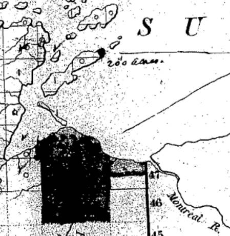
March 30th, 1855 map from the U.S. General Land Office of lands to be withheld from sale for the La Pointe (Bad River) Reservation from the National Archives Microfilm Publications; Microcopy No. 27; Roll 16; Volume 16. The northeast corner of the Reservation along Lake Superior is accurately located at the mouth of Ke-che-se-be-we-she Creek (not labeled) on this map.
The undersigned persons connected with the Odanah Mission, upon the Bad River Reservation, and also a portion of those Chiefs who were present and signed the Treaty of Sept 30th, AD 1854, would most respectfully call your attention to a few Statements affecting the interests of the Indians within the limits of the Lake Superior Agency, with a view to soliciting from you such action as will speedily see one to the several Indian Bands named, all of the benefits guaranteed to them by treaty stipulation.
Under the Treaty concluded at La Pointe Sept 30th, 1854 the United States set apart a tract of Land as a Reservation “for the La Pointe Band and such other Indians as may see fit to settle with them” bounded as follows.
a.k.a.
Ke-che-se-be-we-she
“Ke-che” (Gichi) refers to big, or large.
“se-be” (ziibi) refers to a river.
“we-she” (wishe) refers to rivulets.
Source: Gidakiiminaan Atlas by the Great Lakes Indian Fish & Wildlife Commission
“Beginning on the South shore of Lake Superior a few miles west of Montreal River at the mouth of a creek called by the Indians Ke-she-se-be-we-she, running thence South &c.”

Detail of the Bad River Reservation from GLIFWC’s Gidakiiminaan Atlas. This map clearly shows that the northeast boundary of Bad River Reservation is not located at the true location of Ke-che-se-be-we-she Creek in accordance with the 1854 Treaty. Red highlights added for emphasis of discrepancies.
Your petioners would represent that at the time of the wording of this particular portion of the Treaty, the commissioner on the part of the United States inquired the number of miles between the mouth of the Montreal River and the mouth of the creek referred to, in reply to which, the Indians said “they had no knowledge of distance by miles” and therefore the commissioner assumed the language of “a few miles west of Montreal River” as discriptive of the creek in mind. This however, upon actual examination of the ground, does to the Band the greatest injustice, as the mouth of the creek to which the Indians referred at the time is even less than one mile west of the mouth of the Montreal.*
*This creek at the time was refered to as having “Deep water inside the Bar” sufficient for Boats which is definitive of the creek still claimed as the starting point, and is not descriptive of the most westerly creek.
But White men, whose interests are adverse to those of the Indians now demand that the Reservation boundary commence at an insignificant and at times scarcely visible creek some considerable distance west of the one referred to in the Treaty, which would lessen the aggregate of the Reservation from 3 to 4000 acres.
Your petioners, have for years, desired and solicited a settlement of the matter, both for the good of the Indians and of the Whites, but from lack of interest the administrations in power have paid no attention to our appeals, as is also true of other matters to which we now call your attention.
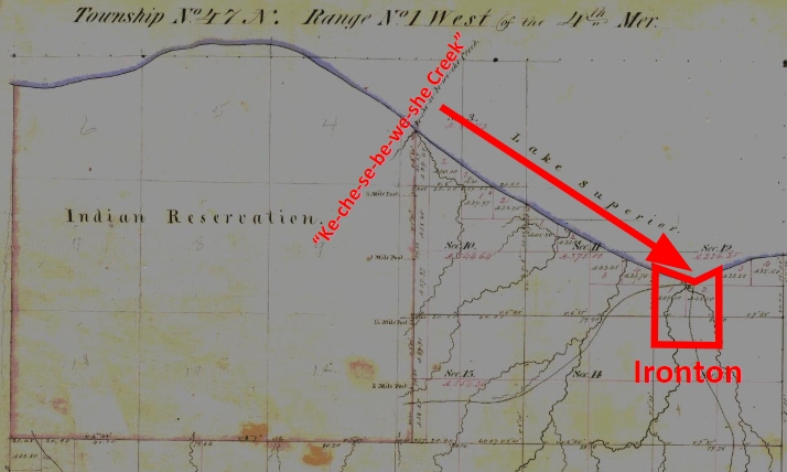
1861 resurvey of Township 47 North of Range 1 West by Elisha S. Norris for the General Land Office relocating Bad River Reservation’s northeast boundary. Ke-che-se-be-we-she Creek was relocated to what is now Graveyard Creek instead of its true location at the Barber Brother’s Ironton townsite location. Red highlights added for emphasis of discrepancies.
As many heads of families now wish to select (within the portion of Town 47 North of Range 1 West belonging to the Reservation the 80 acre tract assigned to them) we desire that the Eastern Boundary of the Reservation be immediately established so that the subdivisions may be made and and land selected.
Your petioners would further [represent?] that under the 3d Section of the 2nd article of the Treaty referred to the Lac De Flabeau, and Lac Court Orelles Bands are entitled to Reservations each equal to 3 Townships, (See article 3d of Treaty. These Reservations have never been run out, none have any subdivisions been made.) which also were to be subdivided into 80 acre Tracts.
Article 4th promises to furnish each of the Reservations with a Blacksmith and assistant with the usual amount of Stock, where as the Lac De Flambeau Band have never yet had a Blacksmith, though they have repeatedly asked for one.

Wisconsin State Representative
and co-founder of Ashland
Asaph Whittlesey
As the matters have referred to one of vital importance to these several Bands of Indians, we earnestly hope that you will give your influence towards securing to them, all of the benefits named in the Treaty and as the subject named will demand labor entirely outside of the ordinary duties of an Indian Agent, and as it will be important for some one to visit the Reservations Inland, so as to be able to report intelligently upon the actual State of Things, we respectfully suggest that Mr Asaph Whittlesey be specially commissioned (provided you approve of the plan and you regard him as a suitable person to act) to attend to the taking of the necessary depositions and to present these claims, with the necessary maps and Statistics, before the Commissioner of Indian Affairs at Washington, the expense of which must of necessity, be met by the Indian Department.
Mr Whittlesey was present at the making of the Treaty to which we refer, and is well acquainted with the wants of the Indians and with what they of right can claim, and in him we have full confidence.
In addition to the points herein named should you favor this commission, we would ask him to attend to other matters affecting the Indians, upon which we will be glad to confer with you at a proper time.
The undersigned L H Wheeler and Henry Blatchford have no hesitency in saying that the representations here made are full in accordance with their understanding of the Treaty, at the time it was drawn up, they being then present and the latter being one of the Interpreters at the time employed by the General Government.
Most Respectfully Yours
Dated Odanah Wis July 1861
Names of those connected with the Odanah Mission
[None identified on this draft petition]
Names of Chiefs who were signers to the Treaty of Sept 30th 1854
[None identified on this draft petition]
Although this draft was not signed by Wheeler or Blatchford, or by the tribal leadership that they appear to be assisting, Chequamegon History believes it is possible that a signed original copy of this petition may still be found somewhere in national archives if it still exists.

Great job on this, Mr. Mello! Have you identified other whites who benefited from all this? Others who resisted the exploitation?
Thanks for your posting.
Linda Louise Bryan
Amorin,
An apology for not responding to this post when it first appeared months ago, but only now am I beginning to go back to these things, and times, to start processing and commenting. My wife and I were in the small group when you and Leo presented this material at the Red Cliff Elderly gathering last fall, and I recall how impressed the group was with the issue(s) this raises.
A can of worms that must be examined. Yes, there is much, much, work to be done. Finally, after over 150 years the machinations involving profit-seeking by many hands and minds of those early times are being disclosed.
A belated thanks for your important work!
HDPaap
Thank you both for your kind words. It is nice to know that this research has an audience! Much, much more to come of course. Stay tuned…