Legend of the Montreal River
March 5, 2016
By Amorin Mello & Leo Filipczak
This is a reproduction of “Legend of the Montreal River” by George Francis Thomas from his book: Legends of the Land of Lakes, Or History, Traditions and Mysteries, Gleaned from Years of Experience Among the Pioneers, Voyageurs and Indians: With Descriptive Accounts of the Many Natural Curiosities Met with from Lake Huron to the Columbia River. And the Meaning and Derivation of Names of Rivers, Lakes, Towns, Etc., of the Northwest, 1884, pages 70-73.
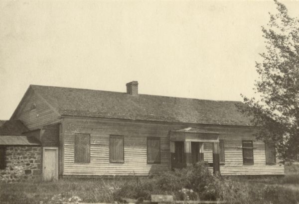
Old Treaty Hall, La Pointe, Madeline Island, cirica 1922.
“At some point in its history the building came into the hands of George Francis Thomas, who in turn presented it to the [Daughters of the American Revolution], but it was destroyed by fires shortly thereafter.”
~ Wisconsin Historical Society
——-
George Francis Thomas married Sarah E. Bell at La Pointe in 1882. Sarah was the daughter of Judge John William Bell of La Pointe and Maraget Brebant of the Sandy Lake Band of Chippewa Indians. Thomas inherited Treaty Hall at La Pointe from the Bell family after his in-laws and wife died. Thomas also inherited many legends from his marriage at La Pointe.

—
Legend of the Montreal River.
—
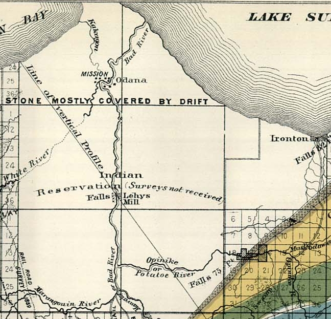
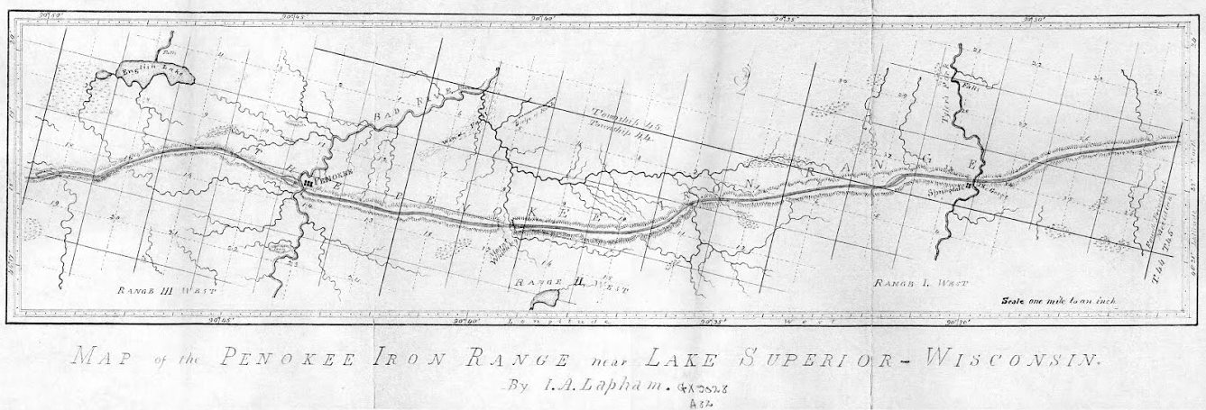
Detail of Odanah, Ironton, and Leihy‘s settlements on the La Pointe Reservation from Charles Whittlesey‘s 1860 “Geological Map of the Penokie Range“ from Geology of Wisconsin, Volume III, plate XX-214. Ironton is located near the mouth of the Montreal River.
Long ago, perhaps fifty years, before a single house or wigwam stood where the city of Ashland now spreads its mammoth protecting wings, there was an Indian settlement on Bad River and another near the beautiful falls on the Montreal. A short distance above its mouth and within sight of the lake, the red sandstone rocks rise boldly to the height of eighty feet, forming a ledge over which the entire volume of water is precipitated into a deep, circular basin or amphitheater, presenting a scene novel and strikingly beautiful. About three miles up the stream is another similar fall, very beautiful, but not so interesting as the first.
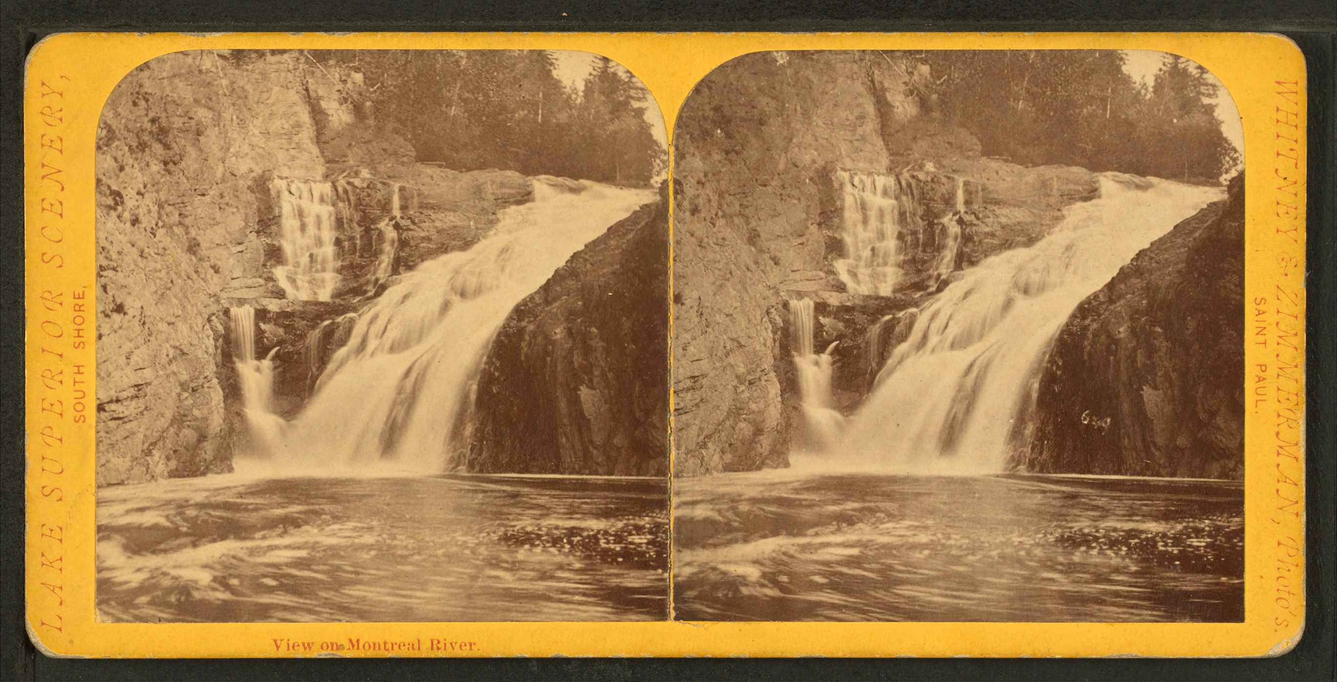
Superior Falls at the mouth of the Montreal River; featured in the stereograph titled “View on Montreal River” by Whitney & Zimmerman from St. Paul, circa 1870.
~ Wikimedia Commons
“Skirting the southern shore of the lake, past the now famous Pictured Rocks, [Pierre d’Esprit, Sieur Radisson, and his sister’s husband, Medard Chouart, Sieur de Groseilliers] carried across Keweenaw Point, visited a band of [Cree] Indians not far from the mouth of Montreal River, now the far western boundary between Upper Michigan and Wisconsin, and, portaging across the base of the Chequamegon Island of to-day, – then united to the mainland,- entered beautiful Chequamegon Bay.”
~ The Story of Chequamegon Bay by Reuben Gold Thwaites.
Below this lovely waterfall and near the shore of the lake, once dwelt the chief a Chippewa band, and near his wigwam were clustered a number of his warriors. Their time was passed in the chase and in fishing; the squaws made mats, canoes, and in the spring time maple sugar; and all were happy and prosperous. In this quiet, peaceful circle was enacted the only real love tragedy recorded during many years upon these shores; and this was caused by the cruel inconstancy of a white man, who had won the heart of an innocent child of nature only to break it, and leave her to mourn and die, as many a fairer, but no less pure maiden had been left before.

Detail of the Rivière du Montreal (Montreal River) from the Carte de l’Amerique Septentrionnale by Jean Baptiste Louis Franquelin, 1688.
~ Library of Congress
It seems that the simple girl had been won by the gew-gaws and glitter – so attractive to the forest maiden – brought here by a young American for trade. At first she only sought his wares, of which, owing to her standing in the tribe as the chief’s daughter, she was enabled to purchase a full share. Decked out in all the latest finery of civilization, she, woman-like no doubt, began to exhibit her new acquisitions in a spirit of rivalry, which, of course, soon begat jealousy in the hearts of her female companions. At this point Cupid came to the front; for if there is one thing more than another which a woman delights in, it is to monopolize the attention of the beau of society. In this particular society, for such really exists among the children of the forest, in a manner at least, the young trader reigned supreme. He was sought by all the beauties of the camp, and had no rival; for be it known that the old beaux and stand-bys are always laid on the shelf when a dashing cavalier from civilization appears – especially when he is an American, and of course rich – for all Americans are either rich or worthless in the eyes of the natives. This bold, bad man was the favored one, no Frenchman or half-caste Indian stood the least show, and ere the joyful days of spring time had gone, two hearts beat as one. The chief’s daughter and the young American were to be married, the gossips said. Time passed and the white man went below to buy goods. He returned, and went once more after many happy hours and days had rolled by; but the maid now began to get impatient. She dreamed that the white man loved another, which may have been true, for he never returned again. At their last parting she bade him farewell, never intimating her suspicions until his canoe was launched upon the waters, and as he paddled away her song of reproach, full of melody and pathos greeted his most unwilling ears. The notes, clear and sweet, floated out over the rising billows, until the truant lover was far beyond. Her words in part were these:
“That water on whose bosom bright,
With joy I’ve seen your bark appear;
You cross no longer with delight,
Nor I with joy, your greeting hear.False words are thine; tho’ now you sigh
I know your grief is not sincere;
‘Tis well our dreaded parting’s nigh;
I bid farewell to pleasure dear.When o’er the waters wide and deep,
Far, thine Ojibway maid shall be,
New loves will make you please to weep,
Nor e’er again remember me.”
With this the fairest of all the tribe, the beloved child of a kind father, confiding and loving, thoughtless and innocent, the merry chirping bird of the forest, and the forsaken fawn, left to die of a wounded heart, wandered far away and was lost in the impenetrable pine forest.
Detail of the Chippewa village (Ironton), at Saxon Harbor, near the mouth of the Montreal River and Superior Falls; with footpaths leading East towards Odanah, and South into the Penokee Mountains …
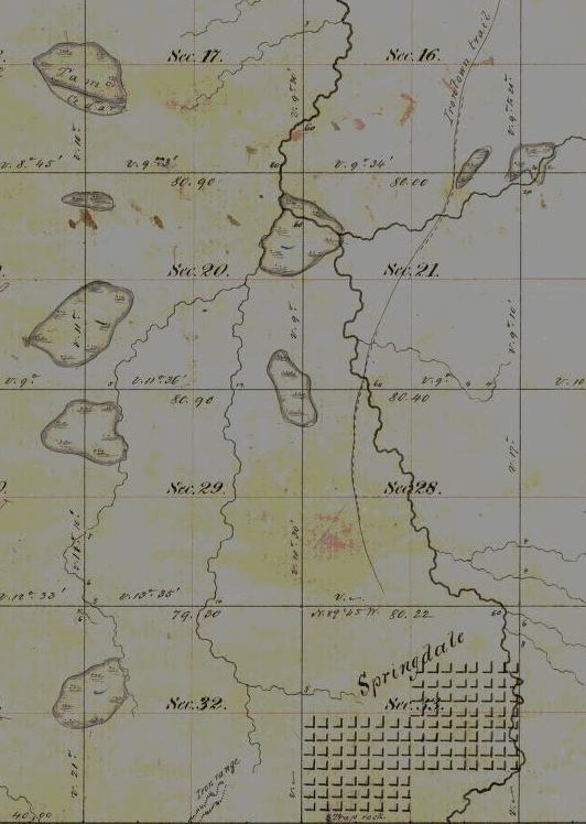
… leading to the Wisconsin & Lake Superior Mining & Smelting Company‘s town-site Springdale at The Gorge on Tyler Forks River.
~ Wisconsin Public Land Survey Records
[…]
“Rome was not built in a day, but most of these cabins were. I built four myself near the Gorge [on Tyler Forks River], in a day, with the assistance of two halfbreeds, but was not able to find them a week afterwards. This is not only a mystery but a conundrum. I think some traveling showman must have stolen them; but although they were non est we could swear that we had built them, and did.“
~ Penokee Survey Incidents: IV
Years afterwards, about 1857, there was considerable excitement in these regions on account of copper discoveries in the range near where it crosses Bad River. Buildings were erected on the banks of Tyler’s Fork, and near the falls, the remains of which are visible at the present day. Mines were opened with fair prospects, but there was no use to try to stem the tide, the current was too strong, transportation was too primitive, and the mines were abandoned. Not, however, until a strange discovery had been made. One day while engaged in exploring below the falls, a workman noticed in a pool what he at first took for a water-soaked section of a log. It was covered by some two feet of water and on closer contact was found to be a solid rock, but in form and size of a human being; in fact it was a petrified Indian woman. How it came there is a mystery. Only a few ever knew of the discovery, for it was kept a secret until it was carried away and sold to a New York Museum. Those who saw the petrified body and knew the story of the chief’s daughter failed not to connect here the two mysteries of the pine forest.
Bad River1 receives its waters partially from a marsh just south of the Penokee range, and besides being dark in color, it possesses some peculiar qualities which may have caused the petrifaction of the body of the young girl after she had drowned herself, as she most likely did.
1 The Chippewa name for Bad River is Mus-ke-ze-bing, meaning river from the marsh. Because the water was discolored the white men thought the Indian name meant dirty or impure water.

Wabigance below the Gorge on the Tyler Forks River.
~ Photograph by M. Matusewic © December 2013.
Reproduced with permission.
Penokee Survey Incidents: Number IV
February 22, 2015
By Amorin Mello

December 8, 1877.
Increase Allen Lapham surveyed the Penokee Iron Range in September of 1858 for the Wisconsin & Lake Superior Mining and Smelting Company. Years later, Lapham’s experience was published as “Mountain of Iron Ore: The buried wealth of Northern Wisconsin“ in the Milwaukee Evening Wisconsin newspaper on February 21, 1887. (Image courtesy of the University of Wisconsin Geography Department)
~ 1978 Marsden Report for US Steel.
~ Railroad History, Issues 54-58, pg. 26
The Penoka Iron Range consists, as is well known, of a sharp ridge, some fifteen miles in length, by from one to one and one half in breadth, with a mean elevation of 700 feet above Lake Superior, from which is a distance about twenty-two miles, as the crow flies, its general trend being nearly east and west, it is densely covered with timber consisting of sugar maple, (of which nearly every tree is birdseye or curly) elm, red cedar, black, or yellow birch, some of which are of an enormous girth, among which are intermixed a few white pine and balsams, for it is traversed from north to south at three different points, by running streams, upon each of which the company had a station, the western being known in the vernacular of the company, as Palmer’s, (now Penoka); the center, as Lockwood’s, in honor of John Lockwood, who was at the time a prominent member of the Company, and upon its executive board; and the eastern, as Sidebotham’s, or “The Gorge.” These were the principal stations or centers, where supplies and men were always kept, and as which, as before stated, more or less work had been done the previous year. Penoka, as which the most work had been done, being considered by far the most valuable. This post was, at the time of my first visit, by charge of S.R. Marston, of whom mention was made in my last, and two young boys from Portsmouth, N.H., who had come west on exhibition, I should say, from the way they acted. They soon left, however, too many mosquitoes for them. “Lockwood’s,” as previously stated, was garrisoned by one man, whose name I have forgotten, and although a great amount of work had been done here as yet, it was nevertheless considered a very valuable claim, on account of the feasibility with which it could be reached by the rail Mr. Herbert had in contemplation to build from Ironton, and which would, in passing along the north side of the Range, come in close proximity to this station; besides, it had the additional advantages of a fine water power. At the east end were two half-breeds employed by the company, and George Chase, a young man from Derby, Vermont, a nephew of ex-Mayor Horace, and Dr. Enoch Chase, of Milwaukee, an employee of Stuntz, who, with James Stephenson, was awaiting the return of Gen. Cutler with reinforcements, in order to continue the survey. Chase subsequently made a claim which he was successful in securing – selling it finally to the Mr. Cogswell, of Milwaukee.
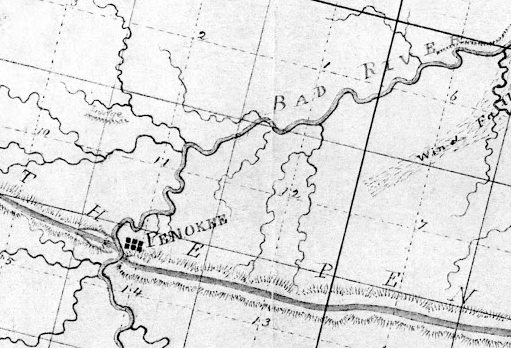
Penoka, aka Penokee, is Palmer’s station near the Bad River Gap.
It is also proper to state in addition to what has been already mentioned, that at, or about this time, a road was opened by Mr. Herbert’s order, from the Hay Marsh, six miles out from Ironton, to which point one had been previously opened, to the Range, which it struck about midway between Sidebotham’s and Lockwood’s Stations, over which, I suppose, the 50,000 tons as previously mentioned, was to find its way to Ironton, (in a horn). For this work, however, the Company refused to pay, as they had not authorized it; neither had Mr. Herbert, at that time, any authority to contract for it, except at his own risk; his appointment as agent having already been revoked; although his accounts had not, as yet, been fully settled. This work, which was without doubt, intended to commit the company still further in favor of Ironton as an outlet for the iron, was done by Samuel Champner, a then resident of Ashland and who if living is probably that much out of pocket today. No use was ever made of this road by the Company, not one of their employees, to my knowledge, ever passing over it.

The location of Lockwood’s station was not mapped by Lapham or by Stuntz. City Creek and Ballou Creek are the two water gaps on either side of Mount Whittlesey, midway between the gaps of Bad River and Tyler’s Fork.
This description will, I think, give your readers a very good understanding of the condition as well as the true inwardness of the affairs of the Wisconsin & Lake Superior Mining and Smelting Co., in the month of June, 1857.
At length, after remaining on the Range nearly three weeks, awaiting, Micawber like, for something to turn up, a change came with the arrival of Gen. Cutler from Milwaukee with the expected reinforcements. Mr. Herbert at once left the Range, went to Milwaukee and settled up with the Company, after which, to use a scriptural expression, “he walked no more with us.”

Springdale is Sidebotham’s station at The Gorge of Tyler Fork’s River.
“A special defense in contract law to allow a person to avoid having to respect a contract that she or he signed because of certain reasons such as a mistake as to the kind of contract.”
~ Duhaime.org
Wheelock, Smith, and McClellan were at once placed upon claims – McClellan in the interest of John Cummings, (whose name by an oversight was also omitted from the list of stockholders, given in my first paper), and Wheelock and Smith for the Company generally. Subsequently, A.S. Stacy, of Canada, was also employed to hold a claim. How well he performed this duty, will be seen further on. This done, the improvements necessary to be made in order to entitle us to the benefits of the preemption law were at once commenced. These improvements consisted of log cabins, principally, of which some twenty in all were erected upon the different claims. These cabins would have been a study for Michel Angelo, or Sir Christopher Wren. They had more angles than the Forty-seventh Problem of Euclid, with an average inclination of fifteen degrees to the Ecliptic. O, but they were “fearfully and wonderfully made,” were these cabins. Their construction embodied all the principle points of architecture in the Ancient as well as Modern–Milesian-Greek, mixed with the “hoop skirt” and Heathen Chimee. Probably ten dollars a month would have been considered a high rent for any of them. No such cabins as those were in exhibition at the Centennial, no sir. Rome was not built in a day, but most of these cabins were. I built four myself near the Gorge, in a day, with the assistance of two halfbreeds, but was not able to find them a week afterwards. This is not only a mystery but a conundrum. I think some traveling showman must have stolen them; but although they were non est we could swear that we had built them, and did.
Springdale townsite plan at Sidebotham’s station by The Gorge of Tyler’s Fork in close proximity to the Ironton Trail and Iron Range. (Detail of Stuntz’s survey during August of 1857.)
Three were accordingly platted — one at Penoka, one at Lockwood‘s and one at the Gorge. And in order that it might be done without interfering with the regular survey, Gen. Cutler decided to place S.R. Marston who, in addition to his other accomplishments, claimed to be a full-fledged surveyor, in charge of the work, assisted by Wheelock, Smith and myself. He commenced at the Gorge, run three lines and quit, fully satisfied that he had greatly overestimated his abilities. We were certainly satisfied that he had. A drunken man could have reeled it off in the dark and come nearer the corner than he did. He was a complete failure in every thing he undertook. He left in the fall after the failure of the Sioux Scrip plot. Where he went I never knew. George E. Stuntz was subsequently put upon the work, which he was not long in doing, after which he rejoined Albert on the main work. This main work, however, for the completion of which we were all so anxious, was very much delayed, the cause for which we did not at the time fully understand, but we did afterwards. J.S.B.
