Among The Otchipwees: III
July 20, 2016
By Amorin Mello
… continued from Among The Otchipwees: II

Magazine of Western History Illustrated
No. 4 February 1885
as republished in
Magazine of Western History: Volume I, pages 335-342.
AMONG THE OTCHIPWEES.
III.
The Northern tribes have nothing deserving the name of historical records. Their hieroglyphics or pictorial writings on trees, bark, rocks and sheltered banks of clay relate to personal or transient events. Such representations by symbols are very numerous but do not attain to a system.
Their history prior to their contact with the white man has been transmitted verbally from generation to generation with more accuracy than a civilized people would do. Story-telling constitutes their literature. In their lodges they are anything but a silent people. When their villages are approached unawares, the noise of voices is much the same as in the camps of parties on pic-nic excursions. As a voyageur the pure blood is seldom a success, and one of the objections to him is a disposition to set around the camp-fire and relate his tales of war or of the hunt, late into the night. This he does with great spirit, “suiting the action to the word” with a varied intonation and with excellent powers of description. Such tales have come down orally from old to young many generations, but are more mystical than historical. The faculty is cultivated in the wigwam during long winter nights, where the same story is repeated by the patriarchs to impress it on the memory of the coming generation. With the wild man memory is sharp, and therefore tradition has in some cases a semblance to history. In substance, however, their stories lack dates, the subjects are frivolous or merely romantic, and the narrator is generally given to embellishment. He sees spirits everywhere, the reality of which is accepted by the child, who listens with wonder to a well-told tale, in which he not only believes, but is preparing to be a professional story-teller himself.
Indian picture-writings and inscriptions, in their hieroglyphics, are seen everywhere on trees, rocks and pieces of bark, blankets and flat pieces of wood. Above Odanah, on Bad River, is a vertical bank of clay, shielded from storms by a dense group of evergreens. On this smooth surface are the records of many generations, over and across each other, regardless of the rights of previous parties. Like most of their writings, they relate to trifling events of the present, such as the route which is being traveled; the game killed; or the results of a fight. To each message the totem or dodem of the writer is attached, by which he is at once recognized. But there are records of some consequence, though not strictly historical.

Charles Whittlesey also reproduced Okandikan’s autobiography in Western Reserve Historical Society Tract 41.
Before a young man can be considered a warrior, he must undergo an ordeal of exposure and starvation. He retires to a mountain, a swamp, or a rock, and there remains day and night without food, fire or blankets, as long as his constitution is able to endure the exposure. Three or four days is not unusual, but a strong Indian, destined to be a great warrior, should fast at least a week. One of the figures on this clay bank is a tree with nine branches and a hand pointing upward. This represents the vision of an Indian known to one of my voyagers, which he saw during his seclusion. He had fasted nine days, which naturally gave him an insight of the future, and constituted his motto, or chart of life. In tract No. 41 (1877), of the Western Reserve Historical Society, I have represented some of the effigies in this group; and also the personal history of Kundickan, a Chippewa, whom I saw in 1845, at Ontonagon. This record was made by himself with a knife, on a flat piece of wood, and is in the form of an autobiography. In hundreds of places in the United States such inscriptions are seen, of the meaning of which very little is known. Schoolcraft reproduced several of them from widely separated localities, such as the Dighton Boulder, Rhode Island; a rock on Kelley’s Island, Lake Erie, and from pieces of birch bark, conveying messages or memoranda to aid an orator in his speeches.
~ New Sources of Indian History, 1850-1891: The Ghost Dance and the Prairie Sioux, A Miscellany by Stanley Vestal, 2015, page 269.
The “Indian rock” in the Susquehanna River, near Columbia, Pennsylvania; the God Rock, on the Allegheny, near Brady’s Bend; inscriptions on the Ohio River Rocks, near Wellsville, Ohio, and near the mouth of the Guyandotte, have a common style, but the particular characters are not the same. Three miles west of Barnsville, in Belmont County, Ohio, is a remarkable group of sculptured figures, principally of human feet of various dimensions and uncouth proportions. Sitting Bull gave a history of his exploits on sheets of paper, which he explained to Dr. Kimball, a surgeon in the army, published in fascimile in Harper’s Weekly, July 1876. Such hieroglyphics have been found on rocky faces in Arizona, and on boulders in Georgia.

Pointe De Froid is the northwestern extremity of La Pointe on Madeline Island. Map detail from 1852 PLSS survey.
~ Report of a geological survey of Wisconsin, Iowa, and Minnesota: and incidentally of a portion of Nebraska Territory, by David Dale Owen, 1852, page 420.
~ Geology of Wisconsin: Paleontology by R. P. Whitfield, 1880, page 58.
While pandemonium was let loose at La Pointe towards the close of the payment we made a bivouac on the beach, between the dock and the mission house. The voyageurs were all at the great finale which constitutes the paradise of a Chippewa. One of my local assistants was playing the part of a detective on the watch for whisky dealers. We had seen one of them on the head waters of Brunscilus River, who came through the woods up the Chippewa River. Beyond the village of La Pointe, on a sandy promontory called Pointe au Froid, abbreviated to Pointe au Fret or Cold Point, were about twenty-five lodges, and probably one hundred and fifty Indians excited by liquor. For this, diluted with more than half water, they paid a dollar for each pint, and the measure was none too large – neither pressed down nor running over. Their savage yells rose on the quiet moon-lit atmosphere like a thousand demons. A very little weak whisky is sufficient to work wonders in the stomach of a backwoods Indian, to whom it is a comparative stranger. About midnight the detective perceived our traveler from the Chippewa River quietly approaching the dock, to which he tied his canoe and went among the lodges. To the stern there were several kegs of fire-water attached, but weighted down below the surface of the water. It required but a few minutes to haul them in and stave the heads of all of them. Before morning there appeared to be more than a thousand savage throats giving full play to their powerful lungs. Two of them were staggering along the beach toward where I lay, with one man by my side. he said we had better be quiet, which, undoubtedly, was good advice. They were nearly naked, locked arm in arm, their long hair spread out in every direction, and as they swayed to and fro between the water line and the bushes, no imagination could paint a more complete representation of the demon. There was a yell to every step – apparently a bacchanalian song. They were within two yards before they saw us, and by one leap cleared everything, as though they were as much surprised as we were. The song, or howl, did not cease. It was kept up until they turned away from the beach into the mission road, and went on howling over the hill toward the old fort. It required three days for half-breed and full-blood alike to recover from the general debauch sufficiently to resume the oar and pack. As we were about to return to the Penoka Mountains, a Chippewa buck, with a new calico shirt and a clean blanket, wished to know if the Chemokoman would take him to the south shore. He would work a paddle or an oar. Before reaching the head of the Chegoimegon Bay there was a storm of rain. He pulled off his shirt, folded it and sat down upon it, to keep it dry. The falling rain on his bare back he did not notice.

Portrait of Stephen Bonga
~ Wisconsin Historical Society
We had made the grand portage of nine miles from the foot of the cataract of the St. Louis, above Fond du Lac, and encamped on the river where the trail came to it below the knife portage. In the evening Stephen Bungo, a brother of Charles Bungo, the half-breed negro and Chippewa, came into our tent. He said he had a message from Naugaunup, second chief of the Fond du Lac band, whose home as at Ash-ke-bwau-ka, on the river above. His chief wished to know by what authority we came through the country without consulting him. After much diplomatic parley Stephen was given some pequashigon and went to his bivouac.

Joseph Granville Norwood
~ Wikipedia.org

Portrait of Naagaanab
~ Minnesota Historical Society
The next morning he intimated that we must call at Naugaunup’s lodge on the way up, where probably permission might be had, by paying a reasonable sum, to proceed. We found him in a neat wigwam with two wives, on a pleasant rise of the river bluff, clear of timber, where there had been a village of the same name. His countenance was a pleasant one, very closely resembling that of Governor Corwin, of Ohio, but his features were smaller and also his stature. Dr. Norwood informed him that we had orders from the Great Father to go up the St. Louis to its source, thence to the waters running the other way to the Canada line. Nothing but force would prevent us from doing this, and if he was displeased he should make a complaint to the Indian agent at La Pointe, and he would forward it to Washington. We heard no more of the invasion of his territory, and he proceeded to do what very few Chippewas will do, offered to show us valuable minerals. In the stream was a pinnacle of black sale, about sixty feet high. Naugaunup soon appeared from behind it, near the top, in a position that appeared to be inaccessible, a very picturesque object pointing triumphantly to some veins of white quartz, which are very common in metamorphic slate.
Those who have heard him, say that he was a fine orator, having influence over his band, a respectable Indian, and a good negotiator. If he imagined there was value in those seams of quartz it is quite remarkable and contrary to universal practice among Chippewas that he should show them to white men. They claim that all minerals belong to the tribe. An Indian who received a price for showing them, and did not give every one his share, would be in danger of his life. They had also a superstitious dread of some great evil if they disclosed anything of the kind. Some times they promise to do so, but when they arrive at the spot, with some verdant white man, expecting to become suddenly rich, the Great Spirit or the Bad Manitou has carried it away. I have known more than one such instance, where persons have been sustained by hopeful expectation after many days of weary travel into the depths of the forest. The editor of the Ontonagon Miner gives one of the instances in his experience:
“Many years ago when Iron River was one of the fur stations, of John Jacob Astor and the American Fur Company, the Indians were known to have silver in its native state in considerable quantities.”
Men are now living who have seen them with chunks of the size of a man’s fist, but no one ever succeeded in inducing them to tell or show where the hidden treasure lay. A mortal dread clung to them, that if they showed white men a deposit of mineral the Great Manitou would punish them with death.
Several years since a half-breed brought in very fine specimens of vein rock, carrying considerable quantities of native silver. His report was that his wife had found it on the South Range, where they were trapping. To test his story he was sent back for more. In a few days he returned bringing with him quite a chunk from which was obtained eleven and one-half ounces of native silver. He returned home, went among the Flambeaux Indians and was killed. His wife refused to listen to any proposals or temptation from friend or foe to show the location of this vein, clinging with religious tenacity to the superstitious fears of her tribe.
When the British had a fort on St. Joseph’s Island in the St. Mary’s River, in the War of 1812, an Indian brought in a rich piece of copper pyrites. The usual mode of getting on good terms with him, by means of whisky, failed to get from him the location of the mineral. Goods were offered him; first a bundle, then a pile, afterwards a canoe-load, and finally enough to load a Mackinaw boat. No promise to disclose the place, no description or hint could be extorted. It was probably a specimen from the veins on the Bruce or Wellington mining property, only about twenty miles distant on the Canadian shore.
Detail of John Beargrease the Younger from stereograph “Lake Superior winter mail line” by B. F. Childs, circa 1870s-1880s.
~ Commons.Wikimedia.org
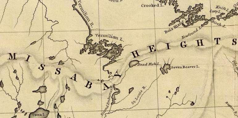
Crossing over the portage from the St. Louis River to Vermillion River, one of the voyageurs heard the report of a distant shot. They had expected to meet Bear’s Grease, with his large family, and fired a gun as a signal to them. The ashes of their fire were still warm. After much shouting and firing, it was evident that we should have no Indian society at that time. That evening, around an ample camp fire, we heard the history of the old patriarch. His former wives had borne him twenty-four children; more boys than girls. Our half-breed guide had often been importuned to take one of the girls. The old father recommended her as a good worker, and if she did not work he must whip her. Even a moderate beating always brought her to a sense of her duties. All he expected was a blanket and a gun as an offset. He would give a great feast on the occasion of the nuptials. Over the summit to Vermillion, through Vermillion Lake, passing down the outlet among many cataracts to the Crane Lake portage, there were encamped a few families, most of them too drunk to stand alone. There were two traders, from the Canada side, with plenty of rum. We wanted a guide through the intricacies of Rainy Lake. A very good-looking savage presented himself with a very unsteady gait, his countenance expressing the maudlin good nature of Tam O’Shanter as he mounted Meg. Withal, he appeared to be honest. “Yes, I know that way, but, you see, I’m drunk; can’t you wait till to-morrow.” A young squaw who apparently had not imbibed fire-water, had succeeded in acquiring a pewter ring. Her dress was a blanket of rabbit skins, made of strips woven like a rag carpet. It was bound around her waist with a girdle of deer’s hide, answering the purpose of stroud and blanket. No city belle could exhibit a ring of diamonds more conspicuously and with more self-satisfaction than this young squaw did her ring of pewter.
As we were all silently sitting in the canoes, dripping with rain, a sudden halloo announced the approach of living men. It was no other than Wau-nun-nee, the chief of the Grand Fourche bands, who was hunting for ducks among the rice. More delicious morsels never gladdened the palate than these plump, fat, rice-fed ducks. Old Wau-nun-nee is a gentleman among Indian chiefs. His band had never consented to sell their land, and consequently had no annuities. He even refused to receive a present from the Government as one of the head men of the tribe, preferring to remain wholly independent. We soon came to his village on Ash-ab-ash-kaw Lake. No band of Indians in our travels appeared as comfortable or behaved as well as this. Their country is well supplied with rice and tolerably good hunting ground. The American fur dealers (I mean the licensed ones) do not sell liquor to the Indians, and use their influence to aid Government in keeping it from them. Wau-nun-nee’s baliwick was seldom disturbed by drunken brawls. His Indians had more pleasant countenances than any we had seen, with less of the wild and haggard look than the annuity Indians. It was seldom they left their grounds, for they seldom suffered from hunger. They were comfortably clothed, made no importunities for kokoosh or pequashigon, and in gratifying their savage curiosity about our equipments they were respectful and pleasant. In his lodge the chief had teacups and saucers, with tea and sugar for his white guests, which he pressed us to enjoy. But we had no time for ceremonials, and had tea and sugar of our own. Our men recognized numerous acquaintances among the women, and as we encamped near a second village at Round Lake they came to make a draft on our provision chest. We here laid in a supply of wild rice in exchange for flour. Among this band we saw bows and arrows used to kill game. They have so little trade with the whites, and are so remote from the depots of Indian goods, that powder and lead are scarce, and guns also. For ducks and geese the bow and arrow is about as effectual as powder and shot. In truth, the community of which Wau-nun-nee was the patriarch came nearer to the pictures of Indians which poets are fond of drawing than any we saw. The squaws were more neatly clad, and their hair more often combed and braided and tied with a piece of ribbon or red flannel, with which their pappooses delighted to sport. There were among them fewer of those distinguished smoke-dried, sore-eyed creatures who present themselves at other villages.
By my estimate the channel, as we followed it to the head of the Round Lake branch, is two hundred and two mile in length, and the rise of the stream one hundred and eight feet. The portage to a stream leading into the Mississippi is one mile.
At Round Lake we engaged two young Indians to help over the portage in Jack’s place. Both of them were decided dandies, and one, who did not overtake us till late the next morning, gave an excuse that he had spent the night in courting an Indian damsel. This business is managed with them a little differently than with us. They deal largely in charms, which the medicine men furnish. This fellow had some pieces of mica, which he pulverized, and was managing to cause his inamorata to swallow. If this was effected his cause was sure to succeed. He had also some ochery, iron ore and an herb to mix with the mica. Another charm, and one very effectual, is composed of a hair from the damsel’s head placed between two wooden images. Our Lothario had prepared himself externally so as to produce a most killing effect. His hair was adorned with broad yellow ribbons, and also soaked in grease. On his cheeks were some broad jet black stripes that pointed, on both sides, toward his mouth; in his ears and nose, some beads four inches long. For a pouch and medicine bag he had the skin of a swan suspended from his girdle by the neck. His blanket was clean, and his leggings wrought with great care, so that he exhibited a most striking collection of colors.
At Round Lake we overtook the Cass Lake band on their return from the rice lakes. This meeting produced a great clatter of tongues between our men and the squaws, who came waddling down a slippery bank where they were encamped. There was a marked difference between these people and those at Ash-ab-ash-kaw. They were more ragged, more greasy, and more intrusive.
CHARLES WHITTLSEY.
Among The Otchipwees: II
June 4, 2016
By Amorin Mello
… continued from Among The Otchipwees: I
Magazine of Western History Illustrated
No. 3 January 1885
as republished in
Magazine of Western History: Volume I, pages 177-192.
AMONG THE OTCHIPWEES.
II.
In the fall of 1849, the Bad Water band were in excellent condition, and therefore very happy. Deer were then very abundant on the Menominee. They are nimble animals, able to leap gracefully over obstructions as high as a man’s head standing. But they do not like such efforts, unless there is a necessity for it. The Indians discovered this long ago, and built long brush fences across their trails to the water. When the unsuspecting animal has finished browsing, he goes for a drink with the regularity of an habitué of a saloon. Seeing the obstruction, he walks leisurely along it, expecting to find a low place, or the end of it. The dark eye of the Chippewa is fixed upon him from the top of a tree. This is much the best position, because the deer is not likely to look up, and the wind is less likely to bear his odor to the delicate nostrils of the game. At such close quarters every shot is fatal. Its throat is cut, its legs tied together, and thrown over the head and shoulders of the hunter, its body resting on his back, and he starts for the village. Here the squaws strip off the hide and prepare the carcass for the kettle. With a tin cup full of flour or a pound of pork, we often purchased a saddle of venison, and both parties were satisfied with the trade.
Naagaanab
~ Minnesota Historical Society
~ Executive Documents of the State of Minnesota for the Year 1886, Volume V.: Minnesota Geographical Names Derived from the Chippewa Language, by Reverend Joseph Alexander Gilfillan, 1887, page 457.
“Akwaakwaa” refers to “go a certain distance in the woods.”
~ General Geology: Miscellaneous Papers, Volume 1: A Report of Explorations in the Mineral Regions of Minnesota During the Years 1848, 1859 and 1864 by Colonel Charles Whittlesey, 1866, page 44.
Of course the man of the woods has a preference as to what he shall eat; but when he is suffering from hunger, as he is a large part of his days, he is not very particular. Fresh venison, bear meat, buffalo, moose, caribou, porcupine, wild geese, ducks, rabbits, pigeons, or fish, relish better than gulls, foxes, or skunks. The latter do very well while he is on the verge of starvation, and even owls, crows, dead horses and oxen. The lakes of the interior of Minnesota and Wisconsin produce wild rice spontaneously. When parched it is more palatable than southern rice, and more nutritious. Potatoes grow well everywhere in the north country; varieties of corn ripen as far north as Red Lake. Nothing but a disinclination to labor hinders the Chippewa from always having enough to eat. With the wild rice, sugar, and the fat of animals, well mixed, they make excellent rations, which will sustain life longer than any preparation known to white men. A packer will carry on his back enough to last him forty days. He needs only a tin cup in which to warm water, with which it makes a rich soup. Pemmican is less palatable, and sooner becomes rancid. This is made of smoke or jerked meat pulverized, saturated with fat and pressed into cakes or blocks. Sturgeon are numerous and large, and when well smoked and well pulverized they furnish palatable food even without salt, and keep indefinitely. Voyagers mix it with sugar and water in their cups. In the large lakes, white fish, siskowit, and lake trout are abundant. In the smaller lakes and rivers there are many varieties of fish. With so many resources supplied by nature, if the natives suffer from hunger it is solely caused by indolence. His implicit reliance upon the Great Spirit, which is his good Providence, no doubt encourages improvidence. Nanganob was apparently very desirous to have a garden at Ashkebwaka, for which I sent him a barrel of seed potatoes, corn, pumpkins, and a general assortment of seeds. Precisely what was done with the parcel I do not know, but none of it went into the ground. In most cases everything eatable went into their stomachs as soon as they were hungry. Even after potatoes had been planted, they have been dug out and eaten, and squashes when they were merely out of bloom. If the master of a lodge should be inclined to preserve the seed and a hungry brother came that way, their hospitality required that the garden should be sacrificed. Their motto is that the morrow will take care of itself. After being well fed, they are especially worthless. When corn has been issued to them to carry to their home, they have been known to throw it away and go off as happy as children.

Detail of the Saint Louis River with the Artichoke River (unlabeled) between the Knife Portage and East Savannah River from Hydrographical Basin of the Upper Mississippi River from Astronomical and Barometrical Observations Surveys and Information by Joseph Nicolas Nicollet, 1843.
~ David Rumsey Map Collection
No footgear is more comfortable, especially in winter, than the moccasin. The Indian knows nothing of cold feet, though he has no shoes or even socks. His light loose moccasin is large enough to allow a wrap of one or more thickness of pieces of blankets, called “nepes.” In times of extreme cold, wisps of hay are put in around the “nepes.” In winter the snow is dry, and the rivers and swamps everywhere covered with ice, which is a thorough protection against wet feet. As they are never pinched by the devices of shoemakers, the blood circulates freely. The well tanned deer skin is soft and a good nonconductor, which cannot be said of the footgear of civilization. In summer the moccasin is light and easy to the foot, but is no protection against water. At night it is not dried at the camp-fire only wrung out to be put on wet in the morning. Like the bow and the arrow, these have nearly disappeared since Europeans have furnished bullets, powder and guns. Before that time the war club was a very important weapon. It was of wood, having a strong handle, with a ball or knot at the end. If the Chippewas used battleaxes of stone, they could not have been common. I have rarely seen a light war club with an iron spike well fastened in the knot or ball at the end. In ancient days, when their arrows and daggers were tipped with flint, their battles were like those of all rude people – personal encounters of the most desperate character. The sick are possessed of evil spirits which are driven out by incantations loud and prolonged enough to kill a well person. Their acquaintance with medical herbs is very complete.
One of the customs of the country is that of concubinage as well as polygamy, resembling in this respect the ancient Hebrews and other Eastern nations. The parents of a girl – on proper application and the payment of a blanket, some tobacco and other et ceteras, amounting to “ten pieces” – bestowing their daughter for such a period as her new master may choose. A further consideration is understood that she is to be clothed and fed, and when the parents visit the traders’ post they expect some pork and flour. To a maiden – who, as an Indian wife or in her father’s house is not only a drudge but a slave, compelled to row the canoe, to cut and bring wood, put up the lodge and take it down, and always to carry some burden – this situation is a very agreeable one. If she wishes to marry afterwards, her reputation does not suffer. While Mr. B. was conversing with the Hudson’s Bay man on the bank, some of the girls came coquettishly down to them frisking about in their rabbit skin blankets well saturated with grease. One of them managed to keep in view what she considered a special attraction – a fine pewter ring on her finger. These Chippewas damsels had in some way acquired the art of insinuation belonging to the sex without the aid of a boarding school.
The Indian agent at La Pointe killed a deer of about medium size, which he left in the woods. He engaged an Indian to bring it in. Night came and the next day before the man returned without the deer. “Where is my deer?” “Eat him, don’t suppose me to eat nothing.” Probably that meal lasted him a week. There is among them no regular time for meals or other occupations. If there are provisions in the lodge, each one helps himself; and if a visitor comes, he is offered what he can eat as long as it lasts. This is their view of hospitality. The lazy and worthless are never refused. To do this to the meanest professional dead beat would be the ruin of the character of the host.
Detail of portage between Lake Vermillion and the Saint Louis River headwaters from Hydrographical Basin of the Upper Mississippi River from Astronomical and Barometrical Observations Surveys and Information by Joseph Nicolas Nicollet, 1843.
~ David Rumsey Map Collection
“Vincent Roy Sr. was born at Leech Lake Minn. in the year 1779 1797, and died at Superior, Wis. Feb. 18th 1872. He was a son of a Canadian Frenchman by the same name as his son bears. When V. Roy, Sr was about 17 or 18 years old, they emigrated to Fort Frances, Dominion of Canada, where he was engaged by the North-West Fur Co. as a trader until the two Companies (the North-West and the Hudson Bay Co joined together) he still worked for the consolidated Company for 12 or 15 years. When the American Traders came out at the Vermillion Lake country in Minnesota Three or four years afterwards he joined the American Traders. For several years he went to Mackinaw, buying goods and supplies for the Bois Fortes bands of Chippeways on Rainy and Vermillion Lake Country. About the year 1839 he came out to the Lake Superior Country and located his family at La Pointe. In winters he went out to Leech Lake Minn., trading for the American Fur Co. For several years until in the year of 1847 when the Hon. H. M. Rice, now of St. Paul, came to this country representing the Pierre Choteau Co. as a fur trading company. V. Roy, Sr. engaged to Pierre Choteau & Co. to trade with his former Indians at Vermillion Lake Country for two years, and then went for the American Fur Company again for one year. After a few years he engaged as a trader again for Peter E. Bradshaw & Co. and went to Red Lake, Minn. for several years. In 1861 he went to Nipigon (on Canadian side) trading for the same company. In a few years, he again went back to his old post at Vermillion Lake, Minn., where he contracted a very severe sickness, in two years afterwards he died at Superior among his Children as stated before &c.”
~ Minnesota Historical Society: Henry M. Rice and Family Papers, 1824-1966; Box 4; Sketches folder; Item “Roy, Vincent, 1797-1872”
Among the Chippewas we hear of man eaters, from the earliest travelers down to this day. Mr. Bushnell, formerly Indian agent at La Pointe, described one whom he saw who belonged on the St. Louis River and Vermillion Lake. The Indians have a superstitious dread of them, and will flee when one enters the lodge. They are hated, but it is supposed they cannot be killed, and no one ventures to make the experiment. it is only by a bullet such as the man eater himself shall designate that his body can be pierced. He is frequently a lunatic, spending days and nights alone in the woods in mid winter without food, traveling long spaces to present himself unexpectedly among distant bands. Whatever he chooses to eat is left for him, and right glad are the inmates of a lodge to get rid of him on such easy terms. The practice is not acquired from choice, but from the terrible necessities of hunger which happen every winter among the northern Indians. Like shipwrecked parties at sea, the weaker first falls a prey to the stronger, and their flesh goes to sustain life a little longer among the remainder. The Chippewas think that after one has tasted human food he has an uncontrollable longing for it, and that it is not safe to leave children alone with them. They say a man eater has red eyes and he looks upon the fat papoose with a demonical glance, and says: “How tender he would be.” One miserable object on the St. Louis River eat off his own lips, and finally became such a source of consternation that one Indian more courageous than the rest buried a tomahawk in his head. Another one who had the reputation of having killed all of his own family, came to the winter fishing ground on Rainy Lake, where Mr. Roy was trading with the Indians. He stayed on the ice trying to take some fish, but without success. Not one of the band dared go out to fish, although they were suffering from hunger. Mr. Roy and all the Indians requested him to go away, but he would not unless he had something to eat. no one but the trader could give him anything, and he was not inclined to do so. Things remained thus during three days, no squaw daring to go on the ice to fish for fear of the man eater. Mr. Roy urged them to kill him, but they said it would be of no use to shoot at him. The man eater dared them to fire. The trader at length lost patience with the cannibal and the terrified Bois Forts. He took his gun and warned the fellow that he would be shot if he remained on the ice. The faith of the savage appears to have been strong in the charm that surrounded his person, for he only replied by a laugh of derision. On the other side Mr. Roy had great faith in his rifle, and discharging it at the body of the man, he fell dead, as might have been expected. The Indians were at once relieved of a dreadful load, and sallied out to fish. No one, however, dared to touch the corpse.
No one of either party can go into the country of the other, and not be discovered. Their moccasins differ and their mode of walking. Their canoes and paddles are not alike, and their camp-fires as well as their lodges differ. The Chippewa lodge or wigwam is made by a circular or oblong row of small poles set in the ground, bending the tops over and fastening them with bark. They carry everywhere rolls of birch bark, which unroll like a carpet. These are wound on the poles next the ground course, and overlapping this a second and third, so as to shed rain. On one side is a low opening covered by a blanket, and at the top a circular place for the smoke to escape. The fire is on the ground at the centre. The work of putting up the lodge is done by the squaws, who gather wood for the fire, spread the mats, and proceed to cook their meals, provided there is anything to cook.

Stereograph of “Chippewa Indians and Wigwams” by Martin’s Art Gallery, circa 1862-1875, shows that they used more than one type of wigwam.
~ Commons.Wikimedia.org
A Sioux lodge is the model of the Sibley tent, with a pole at the centre and others set around in a circle, leaning against the central one at the top, forming a cone. This they cover with skins of the buffalo, deer, elk or moose, wound around like the Chippewa rolls of bark, leaving a space at the top for the smoke to escape, and an entrance at the side. This is stronger and more compact than the Chippewa wigwam, and withstands the fiercest storms of the prairies. In winter, earth is occasionally piled around the base, which makes it firmer and warmer.
We were coming down the Rum River, late in the fall of 1848, when one of our voyageurs discovered the track of a Sioux in the sand. It was at least three weeks old, but nothing could induce him to stay with us, not even an hour. He was not sure but a mortal enemy was then tracking us for the purpose of killing him.
Detail of Red Lake from Hydrographical Basin of the Upper Mississippi River from Astronomical and Barometrical Observations Surveys and Information by Joseph Nicolas Nicollet, 1843.
~ David Rumsey Map Collection
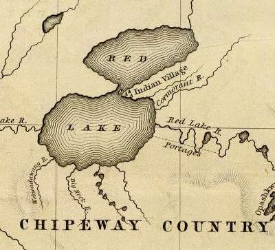
Earlier in the season we were at Red Lake. A cloud of smoke came up from the west, which caused a commotion in the village and mission at the south end of the lake. A war party was then out on a Sioux raid. The chief had lost a son, killed by them. He had managed to get the hand of a Sioux, which he had planted at the head of his son’s grave. But this did not satisfy his revenge nor appease the spirit of his son. He organized a war party to get more scalps, which was then out. A warrior chief or medicine man gains his principal control of the warriors by means of a prophecy, which he must make in detail. If the first of his predictions should fail, the party may desert him entirely. In this case, on a certain day they would meet a bear. When they met the enemy, if they were to be victorious, a cloud of smoke would obscure the sun. It was this darkening of the sky that excited the hopes of the Red Lake band. They were sure there had been a battle and that the Sioux were defeated.
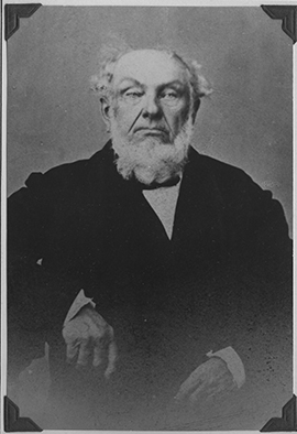
Judge Samuel Ashmun
~ Chippewa County Historical Society
The late Judge Ashmun, of Sault Ste. Marie, while he was a minor, wandered off from his nativity in Vermont to Lake Superior, through it to Fond du Lac, and thence by way of the St. Louis River to Sandy Lake on the Mississippi. Somewhere in that region he was put in charge of one of Astor’s trading posts. In the early winter of 1818 he went on a hunt with a party of seventeen indiscreet young braves, against the advice of the sachems, apparently in a southwesterly direction on the Sioux border, or neutral land. Far from being neutral, it was very bloody ground. At the end of the third day they were about fifty miles from the post. On the morning of each day a rendezvous was fixed upon for the next camp. Each one then commenced the hunt for the day, taking what route pleased himself. The ice on the lakes and marshes was strong and the snow not uncomfortably deep. The principal game was deer, with some pheasants, prairie hens, rabbits and porcupines. What a hunter could not carry he hung upon trees to be carried home upon their return. Their last camp was on the border of a lake in thick woods, with tall dry grass on the margin of the lake. Having killed all the deer they could carry, it was determined to begin the return march the next day. It was not a war party, but they were prepared for their Sioux enemies, of whom no signs had been discerned. There was no whiskey in the camp, but when the stomach of an Indian is filled to its enormous capacity with fresh venison he is always jolly. It was too numerous a party to shelter themselves by a roof of boughs over the fire, but they had made a screen against the wind of branches of pine, hemlock or balsam. Around the fire was a circle of boughs on which they sat, ate and slept. Some were mending their moccasins, other smoking tobacco and kinnikinic, playing practical jokes, telling stories, singing songs and gambling. Mr. Ashmun could get so little sleep that he took Wa-ne-jo, who had a boy of thirteen years, and they made a separate camp. This man going to the lake to drink, was certain that he heard the tramp and felt the vibrations of a party going over the ice, who could be no other than the Sioux. He returned, and after some hesitation Mr. Ashmun reported the news to the main camp. “Oh, Wa-ne-jo is a liar, nobody believes him,” was the universal response. Mr. Ashmun, however, gave credit to the repot. They immediately put out the fire at his bivouac. Even war parties do not place sentinels, because attacks are never made until break of day. In the isolated camp they waited impatiently for the first glimpse of morning. Most of the other party fell asleep with a feeling of security, for which they took no steps to verify. One of them lay down without his moccasins. Mr. Ashmun and his man were just ready to jump for the tall grass when a volley was poured into the other camp, accompanied by the usual savage yell. The darkness and stillness of a faint morning twilight made this burst of war still more terrific. Taking the boy between them, they commenced the race for life under the guidance of Wa-ne-jo, in a direction directly opposite to their home. He well knew the Sioux all night long had been creeping stealthily over the snow and through the thicket, and had formed a line behind the main camp. The Chippewas made a brave defence, giving back their howls of defiance and fighting as they dispersed through the woods. Eight were killed near the camp and a wounded one at some distance, where he had secreted himself. Two fo the wounded were helped away according to custom, and also the barefooted man, whose feet were soon frozen. All clung to their guns, and the frightened boy to his hatchet. They estimated the Sioux party to have been one hundred and thirty, of whom they killed four and wounded seven, but brought in no scalps.

Indians Canoeing in the Rapids painting by Cornelius Krieghoff, 1856.
~ Commons.Wikimedia.org
In his way, the Chippewa is quite religious. He believes in a future world where there is a happy place for good Indians. If he is paddling his canoe against a head wind and can afford it, he throws overboard a piece of tobacco, the most precious thing he has. With this offering there is a short invocation to the good manitou for a fair breeze, when he can raise a blanket for a sail, stop rowing and take a smoke. At the head of many a rapid which it is dangerous to run, are seen pieces of tobacco on the rocks, which were laid there with a brief prayer that they may go safely through. Some of them, which are frightful to white men, they pass habitually. These offerings are never disturbed, for they are sacred. He endeavors also to appease the evil spirit Nonibojan. Fire, rocks, waterfalls, mountains and animals are alive with spirits good and bad. The medicine man, who is prophet, physician, priest and warrior, is an object of reverence and admiration. His prayers are for success in the hunt, accompanied by incantations.

George Bonga
~ Wikipedia.org
Among the stories of a thousand camp-fires, was one by Charlie, a stalwart, half-breed Indian and negro, whose father was an escaped slave. On the shores of Sandy Lake, a party of Chippewas had crossed on the ice in midwinter, and encamped in the woods not far from the north shore. One of them went to the Lake with a kettle of water, and a hatchet to cut the ice. After he filled his kettle, he lay down to drink. The water was not entirely quiet, which attracted his attention at once. His suspicions were aroused, and placing his ear to the ice, he discerned regular pulsations, which his wits, sharpened by close attention to every sight and every sound, interpreted to be the tramp of men. They could be no other than Sioux, and there must be a party larger than their own. Their fire was instantly put out, and they separated to meet at daylight at a place several miles distant. All their conclusions were right. One band of savages outwitted another, having instincts of danger that civilized men would have allowed to pass unnoticed. The Sioux found only the embers of a deserted camp, and saw the tracks of their enemies diverge in so many directions that it was useless to pursue.
In 1839 the Chippewas on the upper Mississippi were required to come to Fort Snelling to receive their payments. That post was in Sioux territory, and the order gave offense to both nations. It required the presence of the United States troops to prevent murders even on the reservation. On the way home at Sunrise River, the Chippewas were surprised by a large force of Sioux, and one hundred and thirty-six were killed.
At the mouth of Crow Wing River, on the east bank of the Mississippi, is a ridge of gravel, on which there were shallow pits. The Indians said that, about fifteen years before, a war party of Sioux was above there on the river to attack the Sandy Lake band. A party of Chippewas concealed themselves in these pits, awaiting the descent of their enemies. The affair was so well managed that the surprise was complete. When the uncautious Sioux floated along within close range of their guns, the Chippewa warriors rose and delivered their fire into the canoes. Some got ashore and escaped through the woods to the westward, but a large portion were killed.
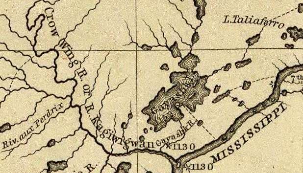
Detail of Crow Wing River from Hydrographical Basin of the Upper Mississippi River from Astronomical and Barometrical Observations Surveys and Information by Joseph Nicolas Nicollet, 1843.
~ David Rumsey Map Collection
While crossing the Elk River, between the falls of St. Anthony and those of St. Cloud, a squaw ran into the water, screaming furiously, followed by a man with a club. This was her lord and master, bent on giving her a taste of discipline very common in Indian life. She succeeded in escaping this time by going into deep water. Her nose had been disfigured by cutting away most of the fleshy portions, as a punishment for unfaithfulness to a husband, who was probably worse than herself.
At the mouth of Crow Wing River was an Indian skipping about with the skin of a skunk tied to one of his ankles. There was also in a camp near the post another Chippewa, who had murdered a brother of the lively man. There is no criminal law among them but that of retaliation. Any member of the family may execute this law at such time and manner as he shall decide. This badge of skunk’s skin was a notice to the murderer that the avenger was about, and that his mission was not fulfilled. Once the guilty man had been shot through the thigh, as a foretaste of what was to follow. The avenger seemed to enjoy badgering his enemy, whom he informed that although he might be occasionally wounded, it was not the intention at present to kill him outright. If the victim should kill his persecutor, he well knew that some other relative would have executed full retaliation.
~ The Assassination of Hole In The Day [the Younger] by Anton Treuer, 2010.
Hole In The Day the Younger
aka Kue-wee-sas (Gwiiwizens [Boy or Lad])
(1825-1868)
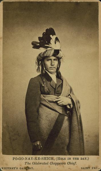
Bagone-giizhig the Younger
~ Wisconsin Historical Society
This Chippewa brave, Bug-on-a-ke-dit, lived on a knoll overlooking the Mississippi River, four miles above Little Rock, where he had a garden. He appeared at the payment at La Pointe, in 1848, with a breech cloth and scanty leggings. This was partially for showing off a very perfect figure, tall, round and lithe, the Apollo of the woods. His scanty dress enabled him to exhibit his trophies in war. The dried ears of his foes, a part of whom were women, were suspended at his neck. Around his tawny arms were bright brass bands, but there was nothing of which he was more proud than a bullet hole just below the right breast. The place of the wound was painted black, and around it circles of red, yellow and purple; other marks on the chest, arms and face told of the numbers he had slain and scalped, in characters well understood by all Chippewas. The numbers of eagle feathers in his hair informed the savage crowd how many battles he had fought. He was not, like Grizzly Bear, a great orator, but resembled him in getting drunk at every opportunity. He managed to procure a barrel of whiskey, which he carried to his lodge. While it was being unloaded it fell upon and crushed him to death. Looking up a grass clad hill, a dingy flag was seen (1848) fluttering on a pole where he was buried. He often repeated with great zest the mode by which the owners of two of the desecrated ears were killed. His party of four braves discovered some Sioux lodges on the St. Peters, from which all the men were absent. The squaws lodged their hereditary enemies over night with their accustomed hospitality. Bug-on-a-ke-dit and his party concealed themselves during the day, and at dark each one attacked a lodge. Seven women and children were slaughtered. His son Kue-wee-sas, or Po-go-noy-ke-schik, was a much more respectable and influential chief.
An hundred years since, the Sioux had an extensive burial ground, on the outlet of Sandy Lake, a few miles east of the Mississippi River. Their dead were encased in bark coffins and placed on scaffolds supported by four cedar posts, five or six feet high. This was done to prevent wolves from destroying the bodies. Thirty years since some of these coffins were standing in a perfect condition, but most of them were broken or wholly fallen, only the posts standing well whitened by age. The Chippewas wrap the corpse in a blanket and a roll of birch bark, and dig a shallow grave in which the dead are laid. A warrior is entitled to have his bow and arrow, sometimes a gun and and a kettle, laid beside him with his trinkets. Over the mound a roof of cedar bark is firmly set up, and the whole fenced with logs or protected in some way against wolves and other wild animals. There is a hole at one or both ends of the bark shelter, in which is friends place various kinds of food. Their belief in a spirit world hereafter is universal. If it is a hunter or warrior, he will need his arms to kill game or to slay his enemies. Their theory is that the dog may go to the spiritual country, as a spirit, also his weapons, and the food which is provided for the journey. To him every thing has its spiritual as well as its material existence. Over all is the great spirit or kitchi-manitou, looking after the happiness of his children here and hereafter.
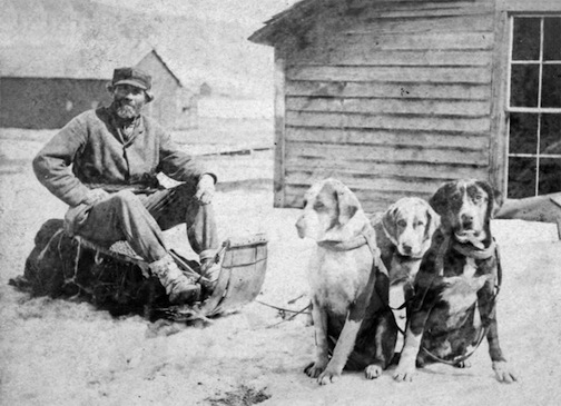
Stephen Bonga
~ Wisconsin Historical Society
Winter travelling in those northern regions is by no means so uncomfortable as white men imagine. By means of snow shoes the Indian can move in a straight course towards his village, without regard to the trail. In the short days of winter he starts at day break and travels util dark. Stephen said he made fifty miles a day in that way, which is more than he could have done in summer.
At night they endeavor to find a thicket where there is a screen against the wind and plenty of wood. They scoop away the snow with their shoes and start a fire at the bottom of the pit. Around this they spread branches of pine, balsam or cedar, and over head make a shelter of brush to keep off the falling snow. Probably they have a team or more of dogs harnessed to sledges, who take their places around the fire. Here they cook and eat an enormous meal, when they wrap themselves in blankets for a profound sleep. Long before day another heavy meal is eaten. Everything is put in its proper package ready to start as soon as there is light enough to keep their course.
– Freelang Ojibwe-English by Weshki-ayaad, Charles Lippert and Guy T. Gambill
– Ojibwe People’s Dictionary by the Department of American Indian Studies at the University of Minnesota
Many Indian words have originated since the white people came among them. A large proportion of their proper names are very apt expressions of something connected with the person, lake, river, or mountain to which they are applied. This people, in their primitive state, knew nothing of alcohol, coffee, tea, fire-arms, money, iron, and hundreds of other things to which they gave names, generally very appropriate ones. A negro is black meat; coffee is black medicine drink; tea, red medicine drink; iron, black metal; gold, yellow metal. I was taking the altitude of the sun at noon near Red Lake Mission with a crowd of Chippewas standing around greatly interested. They had not seen the liquid metal mercury, used for an artificial horizon in such observations, which excited their especial astonishment, and they had no name for it. One of them said something which caused a general expression of delight, for which I enquired the reason. He had coined a word for mercury on the spot, which means silver water.
Detail of Minnesota Point during George Stuntz’s survey contract during August-October of 1852.
~ Barber Papers (prologue): Stuntz Surveys Superior City 1852-1854

This family’s sugar bush was located at or near Silver Creek (T53N-R10W).
~ General Land Office Records
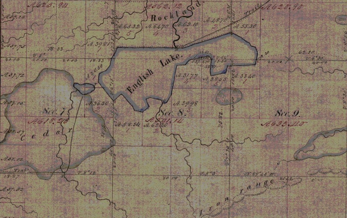
Indian trail to Rockland townsite overlooking English/Mineral Lake and Gogebic Iron Range.
~ Penokee Survey Incidents: Number V
Coasting along the beach northward from the mouth of the St. Louis River, on Minnesota Point, I saw a remarkable mark in the sand and went ashore to examine it. The heel and after part was clearly human. At the toes there was a cleft like the letter V and on each side some had one, others two human toes. Not far distant were Indians picking berries under the pine trees, which then covered the point in its entire length. We asked the berrypickers what made those tracks. They smiled and offered to sell us berries, of which they had several bushels, some in mokoks of birch bark, others in their greasy blankets. An old man had taken off his shirt, tied the neck and arms, and filled it half full of huckleberries. By purchasing some, (not from the shirt or blanket) we obtained an explanation of the nondescript tracks. There was a large family, all girls, whose feet were deformed in that manner. It was as though their feet had been split open when young halfway to the instep, and some of the toes lost. They had that spring met with a great loss by the remorseless bear. On the north shore, thirty miles east of Duluth, they had a fine sugar orchard, and had made an unusual quantity of sugar. A part was brought away, and a part was stored high up in trees in mokoks. There is nothing more tempting than sugar and whiskey to a bear. When this hard working family returned for their sugar and dried apples, moistened with whiskey, to lure bruin on to his ruin. A trap fixed with a heavy log is set up across a pen of logs, in the back end of which this bait is left, very firmly tied between two pieces of wood. This is fastened to a wooden deadfall, supporting one end of a long piece of round timber that has another piece under it. The bear smells the bait from afar, goes recklessly into the pen, and commences to gnaw the pieces of wood; before he gets much of the bait the upper log falls across his back, crushing him upon the lower one, where, if he is not killed, his hind legs are paralyzed. These deadly pens are found everywhere in the western forests. Two bears ranging along the south shore of English Lake, in Ashland County, Wisconsin, discovered some kegs of whiskey which contraband dealers had concealed there. With blows from their heavy paws they broke in the heads of the kegs and licked up the contents. They were soon in a very maudlin state, rolling about on the ground, embracing each other in an affectionate manner and vainly trying to go up the trees. Before the debauch was ended they were easily captured by a party of half-breeds. There are Indians who acknowledge the bear to be a relation, and profess a dislike to kill them. When they do they apologize, and say they do it because they are “buckoda,” or because it is necessary.

Detail of the Porcupine Mountains between the Montreal River and Ontonagon River from Map of the Mineral Lands Upon Lake Superior Ceded to the United States by the Treaty of 1842 With the Chippeway Indians.
~ Wisconsin Historical Society
At Ontonagon, a very sorry looking young Indian came out of a lodge on the west side of the river and expressed a desire to take passage in our boat. There had been a great drunk in that lodge the day before. The squaws were making soup of the heads of white fish thrown away by the white fishermen. Some of the men were up, others oblivious to everything. Our passenger did not become thoroughly sober until towards evening. We passed the Lone Rock and encamped abreast of the Porcupine Mountains. Here he recovered his appetite. The next day, near the Montreal River, a squaw was seen launching her canoe and steering for us. She accosted the young fellow, demanding a keg of whiskey. He said nothing. She had given him furs enough to purchase a couple of gallons and he had made the purchase, but between himself and his friends it had completely disappeared. The old hag was also fond of whiskey. The fraud and disappointment put her into a rage that was absolutely fiendish. Her haggard face, long, coarse, greasy, black hair, voluble tongue and shrill voice perfected that character.
Turning into the mouth of the river we found a party from Lake Flambeau fishing in the pool at the foot of the Great Fall. Their success had not been good, and of course they were hungry. One of our men spilled some flour on the sand, of which he could save but little. The Flambeaus were delighted, and, gathering up sand and flour together, put the mixture in their kettle. The sand settled at the bottom, and the flour formed an excellent porridge for hungry aboriginees.
~ Wisconsin Historical Society
Mushinnewa and Waubannika, Chippewas, lived at Bad River, near Odana. Mushinnewa had a very bad reputation among his tribe. He was not only quarrelsome when drunk, but was not peaceable when sober. He broke Waubannika’s canoe into fragments, which was resented by the wife of the latter on the spot. She made use of the awl with which she was sewing the bark on another canoe, as a weapon, and stabbed old Mushinnewa in several places so severely that it was thought he would die. He threatened to kill her, and she fled with her husband to Lake Flambeau. But Mushinnewa did not die. He had a son as little liked by the Odana band as himself. In a drunken affray at Ontonagon another Indian killed him. The murderer then took the body in his canoe, brought it to Bad River and delivered it to old Mushinnewa. According to custom the Indian handed the enraged father the knife with which his son was killed, and baring his breast told him to strike. The villagers were happy to be rid of the young villain, and took the knife from the hand of his legal avenger. A barrel of flour covered the body, and before night Mushinnewa adopted the Indian as his son.
Two varieties of willow, the red and the yellow, grow on the low land, at the margin of swamps and streams, which have the name of kinnekinic. During the day’s journey, a few sticks are cut and carried to the camp. The outer bark is scraped away from the inner bark, which curls in a fringe around the stick, which is forced in the ground before a hot fire, and occasionally turned. In the morning it is easily crumpled in the hands, and put into the tobacco pouch. If they are rich enough to mix a little tobacco with the kinnekinic, it is a much greater luxury. As they spend a large part of their leisure time in smoking, they are compelled to be content with common willow bark, which is a very weak narcotic. Tobacco is not grown as far north as the country of the Chippewas, but it is probable they had it through traffic with the tribes of Virginia, North Carolina and the Gulf States, in times very remote. Pipes are found in the works of the mounds builders that are very ancient, showing that they had something to smoke, which must have been a vegetable.
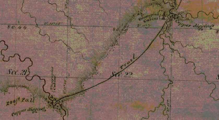
Detail of where the “Lake Long” [Lake Owen] and St. Croix foot paths start along Fish Creek.
~ Barber Papers: “Barbers Camp” Fall of 1855
~ History of the Upper Peninsula of Michigan, by Western Historical Co., 1883, page 276
Staggering around in a drunken crowd at La Pointe was a handsome Chippewa buck, as happy as whiskey can make any one. The tomahawk pipe is not an instrument of war, though it has that form. Its external aspect is that of a real tomahawk, intended to let out the brains of the foe. It is made of cast iron, with a round hollow poll, about the size of a pipe. The helm or handle is the stem, frequently decorated in the height of savage art, with ribbons, porcupine quills, paint and feathers. One thoroughly adorned in this manner has aperatures through the handle cross wise, so large and numerous that it is a mechanical wonder how the smoke can be drawn through it to the mouthpiece. No Indian is without a pipe of some kind, very likely one that is an heirloom from his ancestors. It is only in a passion that his knife or tomahawk pipe becomes dangerous. This genial buck had been struck with the poll of such a pipe when all hands were fighting drunk. It had cut a clear round hole in his head, hear the top, sinking a piece of skull with the skin and hair well into his brains. A surgeon with his instrument could not have made a more perfect incision. Inflammation had not set in and he was too busy with his boon companions to think of the wound. It was about twenty-four hours after it occurred when he stepped into his canoe and departed. When Mr. Beasley went up the Fish River, a few days afterwards a funeral was going on at the intersection of the Lake Long and the St. Croix trails, and the corpse had a cut in the head made by the pole of a tomahawk. From this event, no doubt, a family quarrel commenced that may continue till the race is extinct. The injured spirit of the fallen Indian demands revenge. In the exercise of retaliation it may be carried by his relations a little beyond retaliating justice, which will call on the other side for a victim, and so on to other generations.
In a lodge between the agency and the mission there was a young girl very sick. Probably it is my duty to say that she was not only young but beautiful, but at this time she was only wretched. Whether in her best health and estate the term beauty could be applied I very much doubt, as such cases are extremely rare among Indians, compared by our standard. A “grand medicine” had been got up expressly for the purpose of curing her. The medicine lodge was about thirty feet in length, made of green boughs. The feast, without which no evil spirit would budge one inch, had been swallowed, and the dance was at its height, in which some women were mingled with the men. Their shrieks, yelling and gesticulations should have frightened away all the matchi-manitous at La Pointe. The mother of the girl seemed to be full of joy, the bad spirit which afflicted her child was so near being expelled. As they made the circuit of the dance they thrust a large knife into the air towards the northwest, by which they gave the departing demon a stab as he made his escape from the lodge. This powow raged around the poor girl all the afternoon and till midnight, when the medicine man pronounced her safe. Before sundown the next day we saw them law her in a shallow grave, covered with cedar bark.

Father Nicolas Perrot
~ Wikipedia.org
Father Perret, who was among the Natches as far back as 1730, gives a portrait of a medicine man of that tribe at that time. It answers so well for those I have seen among the Chippewas that I give his description at length. For the Chippewa juggler I must except, however, the practice of abstinence and also the danger of losing his head. A feast is the first thing and the most essential.
“This nation, like all others, has its medicine man. They are generally old men, who, without study or science, undertake to cure all complaints. All their art consists in different jugglings, that is to say, they sing and dance night and day about the sick man, and smoke without ceasing, swallowing the smoke of the tobacco. These jugglers eat scarcely anything while engaged with the sick, but their chants and dances are accompanied by contortions so violent that, although they are entirely naked and should suffer from cold, they are always foaming at the mouth. They have a little basket in which they keep what they call their spirits, that is to say, roots of different kinds, heads of owls, parcels of the hair of deer, teeth of animals, pebbles and other trifles. To restore health to the sick they invoke without ceasing something they have in their basket. Sometimes they cut with a flint the part afflicted, suck out the blood, and in returning it immediately to the disk they spit out a piece of wood, straw or leather, which they have concealed under their tongue. Drawing the attention of the sick man, ‘there,’ they say, ‘is the cause of his sickness.’ These medicine men are always paid in advance. If the sick man recovers their gain is considerable, but if he dies they are sure to have their heads cut off by his relations.”

“Osawgee Beach. Superior, Wis.” postcard, circa 1920:
“Ojibwe chief Joseph Osawgee was born in Michigan in 1802 and came to Wisconsin Point as a young boy. There he established Superior’s first shipyard—a canoe-making outfit along the Nemadji River near Wisconsin Point. His birch bark canoes supplied transportation for both Ojibwe trappers and French Voyageurs. Chief Osawgee signed the 1854 Treaty of La Pointe on behalf of the Fond du Lac Ojibwe—and subsequently lost his land. He died in Solon Springs, Wisconsin, in 1876.”
~ Zenith City Online

Joseph Ozaagii
~ Geni.com
~ Indian Country Today Media Network
“Chief O-sau-gie Built First ‘Ships’ in City of Superior (He Was Head of Small Chippewa Band when Superior was Tiny Spot)”
As a rare example of the industry and probity among northern Indians, I take pleasure in recording the name of Osagi. His hunting ground and sugar camp lay to the west of La Pointe, on Cranberry River, where he had a cabin. In traversing that region I had as a guide a rude map and sketch of the streams made by him on a sheet of post office paper with a red pencil. Osagi was never idle and never drunk. Dr. Livermore was at this time the agent for the tribes at the west end of Lake Superior, and related the following instance of attention and generosity which is worthy of being reported. Osagi frequently made the agency presents, and Dr. Livermore, of course, did the same to his Otchipwee friends. Late in the fall, as the fishing season was about to close, he sent a barrel of delicious trout and white fish to the agency, which, by being hung up separately, would in this cool climate remain good all winter. The interpreter left a message from the donor with the fish, that he did not want any present in return, because in such a case there would be on his part no gifts, and he wished to make a gift. Dr. Livermore assented, but replied that if Osagi should ever be in need the agent expected to be informed of it. During the next winter a message came to Dr. Livermore stating that his friend wanted nothing, but that a young man, his cousin, was just in from Vermillion Lake, where he lived. The young man’s father and family could no longer take fish at Vermillion, and had started for Fonddulac. The old man was soon attacked by rheumatism, and for many days the whole party had been without provisions. Would the agent make his uncle a present of some flour? Of course this was done, and the young messenger started with a horse load of eatables for the solitary lodge of his father, on the St. Louis River, two hundred miles distant. This exemplary Indian, by saving his annuities, and by his economy, had accumulated money enough to buy a piece of land, and placed it in the hands of the agent. when the surveyors had subdivided the township opposite La Pointe, on the mainland, he bought a fraction and removed his family to it as a permanent home. In a few months the small pox swept off every member of that family but the mother.
[CHARLES WHITTLESEY.]
To be continued in Among The Otchipwees: III…
Barber Papers: “In a Little Trouble” Winter of 1856
October 9, 2015
By Amorin Mello
Selected letters of the Joel Allen Barber Papers
… continued from Fall of 1855.
Minnesota Point Jan [23rd?] 1856
Dear Parents
It is sometime since I have wrote to you and for a fortnight or more
[???] [two lines on this copy are illegible] [??? ?????]
On arriving at Lapoint we found sheets from home and a good lot of newspapers.
We left Lapoint Thursday afternoon [on a firm of ?????? ? ?? head?] of [?????????] Nagonup the principal chief of all the Chippewas, Augustus and myself [??? ??? ?????] drawn by by two dogs on a dogtrain. At [????? ???????] were joined by one of Nagonup’s [??????].
Photograph of Naagaanab (Minnesota Historical Society).
They were on their way to Washington. Several of them are going accompanied by a gentleman from Lapointe as interpreter. The first night out we stayed in a wigwam with old Chingoon and his interesting family. Friday night we camped. Saturday reached Iron river. Sunday left and [comfortable?] – Monday came here. Augustus has a sore througt, not severe – otherwise we are well as usual notwithstanding our tramp of over [100?] miles. I must now quit writing and try to find one of our dogs which has strayed over to [???].
Under the old permit system, many locations, three miles square, were made on Lake Superior;- several on and near the Montreal river – some on Bad River, south of La Pointe – three on the main land, opposite La Pointe – two or three were made near Superior City, on the Nemadji, or Left Hand river, and one settler’s claim about twenty miles north of Superior.”
~ Mineral Regions of Lake Superior: As Known From Their First Discovery to 1865, by Henry Mower Rice, 1865[?].
Perhaps you wonder what we have made this journey for – perhaps you hope we are going below but that is not the case. Why should we [?????]. It is warmer here than at many places two or three hundred miles south of here. True – one or two thermometers froze up at this place but others did not while at Fort Snelling, the spirit thermometer inside the walls indicated 44 degrees below zero. Augustus wanted to see to his preemption and I had nothing to do but to come along with him. I also wanted to find out a few things concerning a place that I should like to preempt. I suppose there is not a better copper show on the south shore of the lake, but the land is not surveyed and my only sure way to get it is to settle on it and stick to it until it can be legally claimed.
The town lines will be run next summer.
Augustus is in a little trouble about his claim. It appears his declatory statement never reached the land office. But I guess it will all be explained and made right. The dutchman who was to contest his claim has left the country and would stand no chance if he was here. We have a land office here now which saves a great many journeys to Hudson near St. Paul. We shall go back in a few days and commence surveying around the islands. Now don’t fancy that we cannot survey in the winter, for we have tried it and know better.
Detail from the Stuntz/Barber survey of T47N R14W.
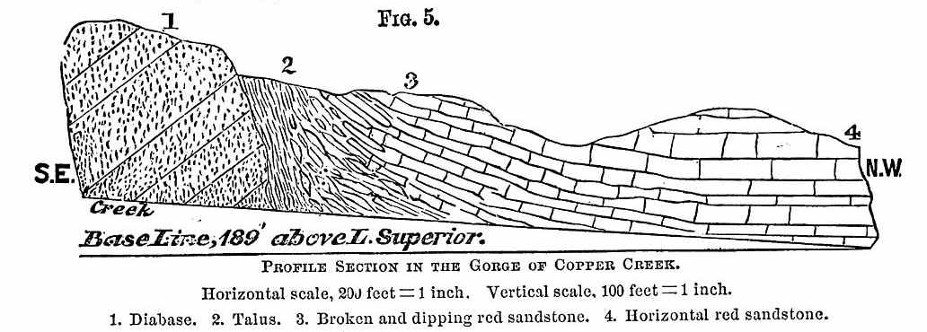
“J.H. Bardon, a Superior pioneer, stated that ‘at Copper Creek and Black River Falls, twelve or fifteen miles south of Superior, and also near the Brule River, a dozen miles back from Lake Superior, Mr. Stuntz found evidences of mining and exploring for copper on a considerable scale carried on by the American Fur Company, under the direction of Borup and Oaks of La Pointe, in 1845-46. A tote road for the mines was opened from a point ten miles up the Nemadji River to Black River Falls.‘”
~ Duluth and St. Louis County, Minnesota; Their Story and People: An Authentic Narrative of the Past, with Particular Attention to the Modern Era in the Commercial, Industrial, Educational, Civic and Social Development, Volume 1, by Walter Van Brunt, 1921, page 66.
At Bad river we were at work during the coldest weather, and only lost two or three days because of cold but when the thermometer was up to 20* below zero we worked right ahead – sometimes in swamps where we stepped through the snow into the water,
[last line on this page of this copy is cut off]
The weather for a week or more has been fine. Cold enough to cover us with frost but not severe.
Provisions are very scarce – no flour or pork can be had.
They will begin to bring them through from St. Paul in a few days. Flour it is hoped can then be bought for $20 per barrel. Fish are not exactly plenty but they can be obtained for money or labor which is not the case with anything else. The country is flooded with dry goods, [p??y] articles and everything but provisions because they can be bought on time but eatables could only be got by paying cash down.
Geology of Wisconsin: Survey of 1873-1879,
Volume III, 1880, page 342[?].

Geology of Wisconsin: Volume 3, page 341.
Geology of Wisconsin: Volume 3, page 345.
The Fon du Lac mine has commenced operations with tolerable fair prospects. It is the only mine in operation this side of Montreal river. Augustus’ claim is on the same vein and for aught anyone knows just as good besides having abundance of water power. All the copper excitement since I come to the country has been directed toward the north shore. This morning I signed 2 petitions, one to congress for the early survey of the north shore and another for a road down that way. I have made a little map of the islands and last summers survey and some other things that I will enclose.
The Fond du Lac copper prospect was located near a small tributary of the Left Hand River on this map detail from T47N R14W, near Pattison State Park. Augustus’ claim was along the same vein of copper but had not been surveyed yet; perhaps it was at Amnicon Falls State Park.
Augustus has begun a letter to send with this. He has just come home with letters now about his claim.
No more at present from
Your affectionate son
J. Allen Barber
Direct to Lapoint
Minnesota Point
Superior County
Minn. Terr.
Sunday Feb 10th 1856
Dear Mother
Augustus has written a letter, and left it for me to enclose and dispatch so I thought I would ship in a few lines before sending it off.
Augustus started today with a young man and two dogs for Lapointe. I shall probably go there in a two or three weeks to return immediately. There are two men going down with a tamlins pony team with provisions from St. Paul for Augustus. The men are going to work for him and I shall probably bring the team back and use it a while. I have at last fixed my mind on a place that I mean to claim. The location is a point at the mouth of Left hand river, known as Left hand point. It contains only 5 or 6 acres in low & swampy and covered only with bushes coarse grass and floodwood. Nothing but the fact of its being a part of Superior city is of any value whatever.

Barber’s sketch of his land claim at the mouth of Left Hand River. This location is now an industrial neighborhood of Superior on the Nemandji River.
As it is $1,000.00 per acre is not an overestimate of its marketable price at present. It joins or is part of the grounds intended for the Railroad buildings when the survey was made here this point was cut off by the meander lines instead of meandered. Therefore according to the [rearns/records?] no such land exists.
A resurvey is to be made and I mean to fasten it by a preemption which is the only way to obtain it before the land sale. I may get cheated out of it and I may throw away my time and money but such chances are scarce and should it transpire that my claim is good I want to have my dish right side up for once. I have written for Uncle Allen’s advice and should I ever find it advisable to drop the matter I can do so without forfeiting my preemption right.
The Eye of the North-west, page 9.
The Superior Company with Company with which I shall probably have to contend is rich, influential, and on good terms with the administration. All that can be done by fair means or foul to defeat any claim will probably be done, but some things can be done as well as others, at any rate we shall see what we shall see.
So my head is so full of business just [snow?] you will please excuse the shortness of this letter and look for more when I have more time.
Your affectionate son
J Allen Barber
Superior Feb. 17th 1856
Dear Brother
It is sometime since I have written anything to you but you have heard of me so often that I suppose it makes no particular difference. It will be nearly sugaring time when you get this.

Makak: a semi-rigid or rigid container: a basket (especially one of birch bark), a box (Ojibwe People’s Dictionary) Photo: Densmore Collection; Smithsonian
I have once more got into a country where sugar is made but not by white men. The Indians make pretty good sugar which is generally done hard and [sinted?] dry and put into birch bark “mo’kucks” holding from 50 to 75 lbs. This bark is also used exclusively for buckets, store trays, gathering pails, &c. The timber in this country is not as equally distributed as in Vermont. The land is mostly covered with evergreens but there are some located portions of country where maple abounds. These “sugar bushes” as they are called are often quite extensive covering several sections and and [they?] only at intervals of 8 or 10 miles, but this is just as well for the Indians are both migratory and gregarious in their habits.
Detail of an Lake Superior Chippewa “sugar bush” from the Barber brothers’ survey of T48N R5W.
I hope you will eat plenty of sugar next spring and take some of the girls to a sugar party or two like I used to. I am doing nothing now most of the time but shall have business enough in a few days when I begin to build my house that is if I conclude to grab for the price of land I am now watching. I am waiting to hear from Uncle Allen and for some other things to transpire. There is not a man in the country whom I could trust that could give me any reliable information such as I want. I want you to hurry and become of age as soon as possible and come out here this spring and make a preemption.
There are some good places left yet, but don’t get married before you make a preemption for it might not be convenient to take your wife out into the woods 30 or 40 miles to live on the place as you would have to do in order to “prove up.” I am going to get up an ice boat before long which will be very useful as I mean to do considerable boating yet this winter, and I might use it to carry lumber and other things up and down the lake. With such winds as we have had a few days ago I could easily go to Lapointe and back in two days. I suppose Augustus got a party started by this time and he will be at it himself in a few days. I am living with a man named Fargo, you have heard of him before. We are living in Stuntz’ store. Board at the hotel is ten dollars per week. Old Steven Bonga is living on the point, he has been something of a traveller having been to Montreal, Hudson Bay, [Oregon?], Prairie du Chien, and all intermediate places.
He is half indian and half negro so you may suppose he is not very white.
Portrait of Stephen Bonga (USDA Forest Service). Additional information about Bonga is available from the Wisconsin Historical Society.
A railroad has been laid out from here to St. Paul and my claim covers the terminus at this end. There have two or three new towns started into existence along its route in imagination. Perhaps they are [surveyed?]. This making towns in a new country is a great business.
What happened in your good town on Christmas and New years eve
Were there any stockings left.
I want to inquire about lots of girls and boys in Johnson and Cambridge but I conclude you will tell me as much as you can in your next letter so with respects to all enquiring friends I remain
Your affectionate brother
Allen
Superior, Douglas Co. Feb. 25th 56
Dear Parents

Detail of Superior City from T49N R1W.
Night before last I got a letter and some papers from Augustus also 2 letters from home which he had read. They were dated Dec. [21st?] & Jan 2nd.
Sad and startling was the news of the death of George Hill. Who could have thought three years ago that such a dark future lay before that family. Every day some sad event warns me of the uncertainty of life. Men have died here who had no friends to mourn their loss, and their death is hardly noticed. I always ask myself why was it not me instead of them and will not my turn come soon. Yes, let it come soon or late as the world reckon, and it will be soon to me.
There is just as much danger or accidents in this country as in any other and no more but as to health there is no better place in the world than this. You seem shocked at the idea of surveying in the winter, but it will be nothing but fun to survey during the rest of the winter. It has been moderate pleasant weather now about two weeks. The snow is going off a little lately and it seems a little like spring. We had some pretty cold weather about new years but we shall have no more such. The lake is more open than it ever was known to be at this season before.
It sometimes freezes across at Lapointe but now it is open within six or eight miles of here. Flour is only $20 per bbl‑ with prospect of falling lower. The Indians chiefs have returned having only been to St. Paul where they found a letter telling them to delay their visit a while.
Poor creatures! They are fooled around by traders and speculators who are with the government in robbing and dwindling them. Any thing like a full account of their wrongs would astonish even them. About my claim I have not [???] today. There is another man after it and it will be no easy thing to carry my point.
Valuable property is troublesome stuff in this country. There is a townsight three miles from there now in litigation for which there is a standing offer of $200,000.
I am still living with Fargo on Minnesota point. I expect to go to Lapointe before long with Albert Stuntz who is going down with some supplies for Augustus which he brought from St. Paul.
It is too dark to write
Good bye
Allen
Superior, March 4th 56
Dear Parents
Not much has happened in this vicinity worth recording. The principle circumstances of note is the burning of a house and all the worldly possessions of a poor [Indian?].
Detail of Left Hand River from Stuntz’s survey; where Barber’s land claim was located.
I have heard nothing of Augustus since writing last but expect to when anybody comes up the lake. About my claim I can say but little my chance is but dull still I don’t mean to give up so large a prize without good reasons.
I have had it surveyed and the notes sent to the Surveyor General with a memorial stating the facts and asking him to [appraise?] the [notes?].
The price contains over 8 acres (8.695).
Perhaps it occurred to you that I am was 22 years old last Sunday. Well such is unquestionably the case although nothing was done to celebrate the day only I had my hair cut for the third time after leaving Vermont. I think I shall have to go to Lancaster this spring but unless I get ousted here it will be difficult to leave.
I wish I could multiply myself by about a dozen in order to hold several valuable claims which are not occupied by any one who can legally hold them. I can’t write here two children [pretting?] and several people [telling?] Albert Stuntz and family are here today. I am perched on a sawhorse writing on a work bench loaded with all manner of [marbles?].
Evening – quiet once more since dark I have written a letter to the Surveyor General to accompany a memorial that I have been circulating. O I wish there was a person in the country that I could depend on to assist me in regard to that claim. There are one or two that I counsel with who know no more than I do and then I do as I think best.
I expect [Lowener?] to find out I have no show, and that will be the last of it I shall [not feel?] that I had lost it for I never had it, but if I don’t get it some body else will get 15 or 20 thousand dollars worth of land that I want.
Provisions are still high and will be higher again before navigation opens which cannot be expected before the 1st of May. Flour is $20/barrel, fresh pork 18 ¾ cents per lb, beef 20 cts milk 20 to 25 cts per qt. &c, &c. Eatables must be higher because there will be little or no sleighing after this over the barrens between here and St. Paul. My mind has been on the [rock?] so much today that I am not in a mood to think much about home so please excuse the shortness and dryness of this letter.
I remain your affectionate son
J Allen Barber
Went to Iron River Thursday 13
Returned 15th
Superior , Douglas Co. March 11 1856
Dear Parents
Yesterday I read a package of letters from Augustus containing one from him & from home one from Albe and one from [Caldridge?]. As Augustus was in town (Lapointe) when he recd. your letters I suppose he has answered them so I cannot tell you much news about him. I am still staying with Fargo – not doing much but hoping to get pay for my time and expense by securing the prize I am after. There is some excitement in town about it, but mighty little is said to me. The Register at the land office gives me good encouragement and says a preemption will hold it. I have taken some steps toward building on it. Today I bought a sack of flour ½ barrel for 12 dollars, I shall get some fish from Lapoint where they are very plenty and cheap and then I shall be almost ready to try housekeeping alone.

I am sorry to hear of the disastrous results of the low price of hops. Although farmers must suffer in consequence yet I believe speculators will make fortunes out of it. If I was in the business of raising them I should stick to it. No articles is so liable to fluctuations in prices as hops but it is well known that the risk fails once in five years on an average so they must come up sometime.
I see you are inclined to believe our country and climate are more in hospitable & forbidding than yours. Such I believe is not the case. We have had some very cold weather but the changes are so moderate and so seldom that we pay but little attention to the weather – in fact we call most all of it very fine weather, as it is. The lake is a great equalizer of temperatures and our cool lake atmosphere in summer causes showers to fall from all the warm, sweaty winds that come here to wash their faces in this big blue pond. People in this country go much better prepared for cold than they ever do in Vermont. I have not worn a boot since leaving Lancaster. We wear shoes in the summer and moccasins in winter.
Boots won’t do for surveyors – they carry too much water unless we stop to empty them after crossing every stream or marsh.
While speaking of clothes perhaps I might as well go on with a few more items of the same sort.
Shoes for this country should have no lining or binding as they are quicker and ae not as stiffwhen dry. We never apply anything to soften them and nothing can preserve them from wearing out in about two months of hard service. They [sell?] about $1.50 per pair. We can get plenty of wool hats which are the only ones we wear.
All manners of shirts can be bought, even the very best quality of red flannel ones, which are universally warm, outside, i.e. by common folks.
The gentry of Superior dress most distressingly.
It is difficult to get good socks any where on the country. I have worn out 6 or 7 pair this summer and lost some more – they cost high bests we don’t wear. I have none. The only cost I have is of [Gihon?] cloth and made by Mrs. Sheldon. Cost are not much more except as an extra garment to wear occasionally.
Good durable pants I find it difficult to get. They are generally poor [ashnet?] and not half put together. Good your mittens would be very acceptable but for want thereof buckskin or blanket mittens are generally warm.
You speak about bringing Kate [in?] to Wisconsin. My advice is to it without fail if you intend coming out to live, nothing should prevent it if I were in your place. The horse that Uncle [Jay?] brought out with him is smarter and tougher than any one he can find to use with him. There is nothing that I regard as more necessary for a family than a first rate horse. I think [Kelty?] will be a very good serviceable animal for work besides being one that you might be proud to ride [after?] over the prairies. Probably Augustus has told you what he thinks about Amherst and other boys coming out here to survey. Butler was so badly disappointed in this country that I have had but little thoughts of [enough?] any one else to come here. Such a disappointment I think would be the fate of 4 out of every 5 that try the business.
A person to be a surveyor must be able to travel all day through the woods and sometimes carry a pack. I would not prevent any from coming here as there is generally business enough besides surveying. A surveyor can make no greater mistake than by hiring any but the best of men. Perhaps Augustus has not told you that he will be out of the business as soon as his present job is done and will devote his time to the improvement of his claim &c. I should like very much to [have?] Amherst here but I dislike to have my parents left entirely alone. As I have [???] two half [sheets?] – when I only [illegible] mind up for the [present?].
[Incomplete copy of letter]
To be continued in the Spring of 1856…
By Amorin Mello
In our Penoka Survey Incidents series earlier this year, we followed some of the adventures and schemes of Albert Conrad Stuntz circa 1857. The legacy of Albert’s influential survey still defines the geopolitical landscape of the Penokee Mountains to this day. However, Albert’s work during the late 1850s was relatively minor in comparison to that of his brother, George Riley Stuntz, during the early 1850s. The surveying work of George and his employees started in 1852 and enabled the infamous land speculators and townsite promotors of Superior City to manifest their schemes by early 1854 (months before the Treaty of La Point occurred later that year).
Among the men that worked with George was Augustus Hamilton Barber. Sometime around 1850, Augustus had followed his Grandparents, Aunts, Uncles, and Cousins from the Barber family of Lamoille County, Vermont, to Lancaster in Grant County, Wisconsin. After a short career as a school teacher in Grant County, Augustus came to Lake Superior in 1852 employed by George as a Chainman under his contract with the United States General Land Office to survey lands at the Head of Lake Superior.
Before taking a closer look at the Barber Papers, let’s examine the lives and affairs of other surveyors and speculators along the southwest shore of Lake Superior, starting with George Riley Stuntz and his production of these Exterior Field Notes (June of 1852):


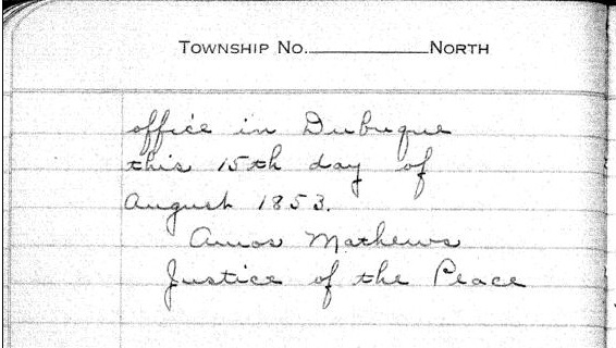
Duluth and St. Louis County, Minnesota;
Their Story and People
By Walter Van Brunt, 1921, pages 64-65.

Portrait of George Nettleton’s cabin on Minnesota Point in 1852 on page 75.
First Settler.– The honor, for both Superior and Duluth, must presumably go to George R. Stuntz. He came in 1852, and settled in 1853. Several were earlier of course, but can hardly be considered to have been legitimate independent settlers. Carlton had been on the ground, at Fond du Lac, for some years, but he was Indian agent; Borup and Oaks had spent their time between La Pointe and Fond du Lac, but were then at St. Paul, and mainly interested in the development of that city, and in fur trading. Wm. R. Marshall stated that he “was on the lake as early as 1848,” but not to settle and he did not come again until 1857. Wm. R. Marshall and George R. Stuntz were fellow-surveyors, in federal pay, “back in the ’40s,” but Marshall did not seek to take the place of Stuntz as premier pioneer at the head of Lake Superior. As a matter of fact, although “on the lake as early as “1848,” Marshall did not then get nearer to Duluth than La Pointe, where he met “Borup and Oaks, the principal traders, Truman Warren, George Nettleton, Cruttenden, Wattrous, Rev. Sherman Hall, E. F. Ely and others.” It is quite possible that Stuntz was with Marshall in 1848, for that was the year in which Stuntz first entered Minnesota territory “having charge of a surveying party that was working near Lake Pepin and in what is now Washington County.”
The “Heart of the Continent.”– George R. Stuntz prepared the way for the first attempt at white settlement at the head of Lake Superior. He surveyed the land on the Wisconsin side, within a year of beginning which survey, in 1852, the first settlers began to appear. George R. Stuntz came by direction of George B. Sargent, who at the time was surveyor-general of the Iowa, Wisconsin and Minnesota district for the federal government, his headquarters being at Davenport, Iowa. In that year, states Carey, “he surveyed and definitely located a portion of the northeastern boundary line between Minnesota and Wisconsin, starting from the head of navigation on the St. Louis River, at Fond du Lac, and running south to the St. Croix River.” Stuntz himself stated: “I came in 1852. I saw the advantages of this point (Minnesota Point) as clearly then as I do now (1892). On finishing the survey for the government, I went away to make a report, and returned the next spring and came for good. I saw as surely then as I do now that this was the heart of the continent commercially, and so I drove my stakes.”
![Group of people, including a number of Ojibwe at Minnesota Point, Duluth, Minnesota [featuring William Howenstein] ~ University of Minnesota Duluth, Kathryn A. Martin Library](https://chequamegonhistory.com/wp-content/uploads/2015/06/howenstein-minnesota-point.jpg)
Group of people, including a number of Ojibwe at Minnesota Point, Duluth, Minnesota [featuring William Howenstein in 1872?] ~ University of Minnesota Duluth
The Vanguard.– He did not come alone, needing of course assistants in the work of surveying, but he was in charge of the work, Gand necessarily takes first place in the accounting. William C. Sargent, son of George B. Sargent, stated in 1916, that his father “came here (Duluth) first in 1852 with George R. Stuntz and Bill Howenstein,” and goes on to state “a word of those two grand men, George R. Stuntz and Bill Howenstein.” He believed that “to George R. Stuntz, more than to any other man belongs the honor (of) opening up that region,” and of Howenstein, he said: “And old Bill Howenstein, one of the best ever, and always my very good friend, a kindly body, with a quaint dry humor unsurpassed and seldom met with in these later days. I had many an interesting chat with him, in his home on Minnesota Point, that he built in 1852, and lived in until his death, some years ago.” Bill Howenstein, undoubtedly was of Stuntz’ party in 1852, but it is doubtful whether he built a log house on Minnesota Point in that year. As to General Sargent’s visit in 1852. If he did come then, it was probably only a flying visit. His interest in the head of Lake Superior in 1852 reached only to the extent of directing Stuntz to survey it. He, himself, had the surveying business of three states to attend to.
The New York Times
[December 11, 1852]
The Region about the Southwest End of Lake Superior.
Mr. Stuntz, of Grant County, Wis., has been deputed by the general Land Surveyor of this Northwest District to lay off such a tract of land about the southwest point of the lake into townships and sections, as emigrants will earliest require. He returned via La Pointe and Stillwater last week. We have obtained from him some new views of that region. From Fond du Lac, a trading post situated 11 miles inland on the St. Louis River, eastward, for perhaps 50 miles, the margin of the lake is a flat strip of land reaching back to a rocky ridge about 11 miles off. The soil of this flat land is a rich red clay. The wood is white cedar and pine of the most magnificent growth. The American line is beyond the mouth of the St. Louis and Pigeon rivers. It evidently abounds in copper, iron and silver. The terrestrial compass cannot be used there, so strong is the attraction to the earth. The needle rears and plunges “like mad.” Points of survey have to be fixed by the solar compass.
The Indian and half breed packmen have astonishing strength. One Indian, who is described by the others as being as large as two men, carried for a company of 11 men provisions for ten days, viz: one barrel of flour, half barrel of pork and something else, beside the utensils. Mirage is a common phenomenon is Spring and Summer. For the bays not opening as soon as the main lake, or not cooling so early, an object out on the lake, is viewed from the shore, through a dense medium of air and a thin medium. Hence is a refraction of rays which gives so many wonderful sights that the Chippewas call that the spirit or enchanted land. Sail vessels which are really 40 miles off, are seen flapping and bellying about almost within touch. Turreted Islands, look heavy and toppling towards the zenith. Forests seem to leap from their stems and go a soaring like thistles for the very sport of it.
The ice did not leave some of the bays till the 10th of June. The fish are delicious, especially the salmon trout. But little land game. Mr. Stunts calculates on wonderful enterprises in that country after the opening of the Saut Canal.
Mr. S. describes La Pointe a town of the Lake, as being situated at the head of a bay some 25 miles from the high lake, and secluded from the lake by several islands. He saw there a warehouse 300 feet long, built of tamarac poles, and roofed with bark. This building is very much warped by the pressure of age ; it is entered by a wooden railway. The town is dingy and dreary. He saw a most luxurious garden by the former residence of Dr. Borup. It contained a variety of fruit trees and shrubs, such as plums, cherries, apples, pears, currants, &c.

Cover of Stuntz’s Exterior Field Notes (August-October 1852) ~ Wisconsin Public Land Survey Records: Original Field Notes and Plat Maps

George Riley Stuntz was also assisted by his brother Albert Conrad Stuntz as well as the African-Chippewa mixed-blood Stephen Bonga employed as an Axeman. To learn more about the interesting Bonga (Bonza) family and Stephen as “the first white child born at the head of Lake Superior,” read pages 39-41 of The Black West by William Loren Katz (1971), and pages 131-34 of Black Indians also by Katz (2012).
The Eye of the North-west: First Annual Report of the Statistician of Superior, Wisconsin
By Frank Abial Flower, 1890

Portrait of Stephen Bonga, page 7.
GEORGE R. STUNTZ, DEPUTY U. S. SURVEYOR [pages 50-52]

Portrait of George Riley Stuntz, page 26.
In 1852 George R. Stuntz took a contract to run the township lines in this part of the country, including the state boundary, and filed with the land-office at Dubuque a rude map of the head of the lake, on the Wisconsin side, in December of that year. He took a new contract and returned in the spring of 1853 to survey the copper range around Black River, a few miles south of Superior. He brought seeds with him and planting them on the Namdji, raised a quantity of vegetables; they grew to great size. he also built a trading-post on Minnesota point near the present light-house, and a mill on Iron River in Bayfield county. In respect of these operations W. W. Ward writes from Morley, Mo.:
The first lumber of any description produced locally, other than by “Whip sawing”, was at Iron River, Wisconsin about forty miles from Superior on the South Shore of Lake Superior.
George R. Stuntz with William C. Howenstein, Andrew Reefer and George Falkner built and operated a water power “up and down” sawmill at the falls on Iron River about a half a mile from the Lake, capable of cutting three thousand feet of lumber a day. The writer has several 1 1/4 inch absolutely “clear” White Pine boards 24 and 26 inches wide and 18 feet long that were originally stored in a loft to be used in building a skiff. This mill was built in 1854 and the lumber was floated up the Lake to Superior, Oneota and Fond du Lac…
~ Superior, Wisconsin, papers, 1831-1942 ([unpublished])
From “A Pioneer of Old Superior” by Lillian Kimball Stewart
“In the summer of ’54 the Sam Ward plying between the Sault and any port on Lake Superior, brought on every trip a goodly number of emigrants, speculators, and tourists, bent on seeing the new “city” of Superior. Stuntz’s dock was located near an Indian village, so that every traveler as well as every piece of freight or baggage was subject to inspection by braves, squaws, and papooses before receiving a passport to the shore across the bay…”
~ Superior, Wisconsin, papers, 1831-1942 ([unpublished])
“It was in the spring of 1853 that Mr. Stuntz, Deputy U. S. Surveyor, received his second contract to survey and run the township lines taking in the range around Black River Falls, a portion of Left-hand River country and that part where Superior now is. In the latter part of April that year he organized a party – viz., Nat. W. Kendall, James McKinzie, Pain Bradt, James McBride, Harvey Fargo, Wm. H. Reed, John Chisholm, Joseph Latham, Augustus Barber, and your humble servant. Procured three birch-bark canoes and supplies at Stillwater, Minn.: left there the first day of May, passed up the St. Croix River to its head, made a portage of about two and a half miles into the headwaters of the Brule River, down said river into Lake Superior, thence up the lake to what was called the entry of St. Louis Bay [now Superior Bay], and landed on Minnesota Point in the early part of June. At that time there were no white settlers in this end of the lake – all Chippewa Indians and ‘breeds’ – scarcely a stick missing on that side of the bay where Superior City now stands. We finished the surveying contract and went in early fall down to Iron River, built a double log-shanty, and made other preparations for the construction of a saw mill. Here the first lumber was made at the head of the lake and the first road opened through to the settlement on the St. Croix. The following February, Mr. Stuntz having a trading-post on Minnesota Point [then Stuntz’s Point], I went there and assisted in building a block-house and steamboat pier, and found improvements and a few log-shanties built where old Superior now is located.”
[…]
HUSTLING FOR TOWNSITES [pages 58-60]
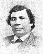
Vincent Roy Jr. ~ Life and Labors of Rt. Rev. Frederic Baraga by Chrysostom Verwyst,
VI. – Superior.
Vincent [Roy Jr.] had barely emerged from the trouble just described when it was necessary for him to exert himself in another direction. A year or so previously he had taken up a claim of land at the headwaters of Lake Superior and there was improvement now on foot for that part of the country, and danger for his interests.
The ship canal at Sault St Marie was in course of construction and it was evidently but a question of days that boats afloat on Lakes Huron and Michigan would be able to run up and unload their cargo for regions further inland somewhere on the shore at the further end of Lake Superior, at which a place, no doubt, a city would be built. The place now occupied by the city of Superior was suitable for the purposes in view but to set it in order and to own the greatest possible part of it, had become all at the same time the cherished idea of too many different elements as that developments could go on smoothly. Three independent crews were struggling to establish themselves at the lower or east end of the bay when a fourth crew approached at the upper or west end, with which Vincent, his brother Frank, and others of LaPointe had joined in. As this crew went directly to and began operations at the place where Vincent had his property it seems to have been guided by him, though it was in reality under the leadership of Wm. Nettleton who was backed by Hon. Henry M. Rice of St. Paul. Without delay the party set to work surveying the land and “improving” each claim, as soon as it was marked off, by building some kind of a log-house upon it. The hewing of timber may have attracted the attention of the other crews at the lower end about two or three miles off, as they came up about noon to see what was going on. The parties met about halfway down the bay at a place where a small creek winds its way through a rugged ravine and falls into the bay. Prospects were anything but pleasant at first at the meeting; for a time it seemed that a battle was to be fought, which however did not take place but the parceling out of ‘claims’ was for the time being suspended. This was in March or April 1854. Hereafter some transacting went on back the curtain, and before long it came out that the interests of the town-site of Superior, as far as necessary for efficient action, were united into a land company of which public and prominent view of New York, Washington, D.C. and other places east of the Mississippi river were the stockholders. Such interests as were not represented in the company were satisfied which meant for some of them that they were set aside for deficiency of right or title to a consideration. The townsite of the Superior of those days was laid out on both sides of the Nemadji river about two or three miles into the country with a base along the water edge about half way up Superior bay, so that Vincent with his property at the upper end of the bay, was pretty well out of the way of the land company, but there were an way such as thought his land a desirable thing and they contested his title in spite of his holding it already for a considerable time. An argument on hand in those days was, that persons of mixed blood were incapable of making a legal claim of land. The assertion looks more like a bugaboo invented for the purpose to get rid of persons in the way than something founded upon law and reason, yet at that time some effect was obtained with it. Vincent managed, however, to ward off all intrusion upon his property, holding it under every possible title, ‘preemption’ etc., until the treaty of LaPointe in the following September, when it was settled upon his name by title of United States scrip so called, that is by reason of the clause, as said above, entered into the second article of that treaty.
The subsequent fate of the piece of land here in question was that Vincent held it through the varying fortune of the ‘head of the lake’ for a period of about thirty six years until it had greatly risen in value, and when the west end was getting pretty much the more important complex of Superior, an English syndicate paid the sum of twenty five thousand dollars, of which was then embodied in a tract afterwards known as “Roy’s Addition”.
~ Biographical Sketch – Vincent Roy Jr; Vincent Roy Jr. Papers.
Up to the time of the survey in the spring of 1854 all was chaos as to lands west of the claims of Robertson, Nelson, Baker and their party. There could be no titles or bona fide purchases, as only the mouth of the Nemadji had been surveyed. There were really three “townsite” companies— Robertson, Nelson and Baker, with their associates J. A. Bullen, J. T. Morgan, E. Y. Shelly, August Zachau, C. G. Pettys, Abraham Emmett, and perhaps others, forming one which had the surveyed lands next to the Nemadji. West of them were Francis Roy, Benjamin Cadotte, Robert Bothwick, Basil Dennis, Charles Knowlton and nearly a dozen half-breeds, mostly brought from Crow Wing by Nettleton in the interest of what was known as the “Hollinshead crowd”—Edmund and Henry M. Rice, George L. Becker, Wm. and George W. Nettleton, Benjamin Thompson, James Stinson and W. H. Newton. Still farther west were Benjamin W. Brunson, A. A. Parker, R. F. Slaughter, C. D. Kimball, Rev. E. F. Ely, George R. Stuntz, Bradley Salter, Joseph Kimball, Calvin Hood, and others who proposed to call their town Endion—”Ahn-dy-yon,” the Chippewa for “home.”
B. W. Brunson, still a resident of St. Paul, has described the contest in writing. He says:
“Believing Superior would become of importance I went there in February, 1854, with R. F. Slaughter. We found some Ontonagon parties had claimed on the bay and we bought an interest in their claims and began to lay out a city and make improvements. While surveying the town, and when we had the same so far completed as to make a plat of it, the township having been subdivided by a good surveyor, then it was that Vincent Roy, Basil Dennis, Charles Brissette and Antoine Warren, accompanied by twenty-one other half-breeds and some four or five white men, headed, led and directed by one Stinson and one Thompson, who were acting for themselves and as agents of the company, came upon the lands to make their claims and avail themselves of pre-emption rights as citizens of the United States. These men were in the employ of the company for the purpose of making claims, and there was a claimant for each and every quarter-section as fast as the surveyor set the quarter-post. They had commenced the day before, with or at the same time the surveyor commenced his work. The timber being dense and there being a strong force, they were able to build an 8×10 cabin and cover it with boughs, upon each quarter, and then overtake the surveyor before he could establish the next quarter, thus taking the land as they went, and in that manner were progressing when they came upon the land marked out and occupied by us.“
The meeting of the two hostile parties occurred on the banks of the deep slough in what is now called Central Park. Nothing but the timidity of the half-breeds prevented bloodshed. Brunson was armed and intended to, and did stand his ground. Thompson, one of the pluckiest of men, was also armed, having two revolvers, and was prepared and intended to proceed. The Indians, not being armed, did not wish to engage in a battle where the leaders only were prepared to fight; and so there was no physical conflict, though a state of chaos and bad feeling continued for some time. Several cabins were demolished, Brunson’s party entirely cutting in pieces a house built by Basil Dennis on the ground now occupied by Dr. Conan’s fine residence.
A long legal contest followed. Finally in 1862-63 patents issued from the government to three men—S. W. Smith, Lars Lenroot and Oliver Lemerise—chosen as trustees of the townsite for the benefit of actual occupants. Thus those who claimed to be proprietors of, but not settlers on the townsite, lost their lands as well as their labor. In the winter of 1853-54 Henry M. Rice asked the Commissioner of the General Land Office whether, when lands which had not been surveyed were claimed for a townsite they would be liable to pre-emption as soon as the survey should be made. The answer was in favor of pre-emption; and that is how those who with Brunson put money into Superior City townsite lost it. The actual settlers got the townsite, the patent being made to the three trustees named who divided the plat, containing 240 acres with riparian rights in Superior Bay, and deeded lots to occupants and purchasers. It may be proper to mention here that a little plat of thirty-four acres, with riparian rights in the bay, and known as Middletown, went through a similar siege of litigation and was finally patented to three trustees —Urguelle Gouge, Louis Morrisette and Nicholas Poulliott—for the benefit of actual occupants. These decisions did not come until the “city” had collapsed and the land become nearly worthless.
The New York Times
[June 19th, 1858]
WESTERN LAND FRAUDS.
More Blood in the Body than Shows in the Face – Land Frauds in the Northwest – The Superior City Controversy – Pre-emptions by Swedes and Indians
Washington, Thursday, June 17, 1858.
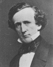
Senator Henry Mower Rice
~ United States Senate Historical Office
There are some interesting matters here besides what takes place in Congress, and I propose from time to time to touch upon them. An expenditure of $60,000,000 per annum does not cover all the pickings and stealings that “prevail” in our hereabouts. Senator RICE did not tell all he knew about land-office operations, when he testified to the value of the Fort Snelling property. Nobody is better aware than he that the tract would be much better to cut up into town lots than Bayfield was when he bought it for a few cents an acre, and sold it for hundreds of dollars. If we could find out all that Senator BRIGHT knows of these matters, one could learn how to become a millionaire at very small expense of brains or labor. Indian treaties and land-office jobbing have made more men rich than care to tell of it – ask General CASS if this is not so.
Seeing a bushel-basket of papers in the Interior Department the other day, I was curious to know what the kernel might be to all that rind, and made inquiry in the premises. I was told that they enveloped the case of Superior City. I cast my eye over some of them, and noticed that an argument was filed on behalf of one of the parties by Mr. Senator BRIGHT – or rather with Senator BRIGHT’S indorsement. This whetted my desire of knowledge, and I ran my eye over the paper in question, which was from the pen of a Minnesota Judge and was without exception the richest document I ever saw intended for a judicial or administrative tribunal. The substance of it was that the opinion of the Attorney-General CUSHING in the case was absurd, the adoption of his views by the Interior Department preposterous, and the action of the local Land office at Superior, in defining the status of certain half-breed Indians on the most abundant testimony, corrupt. It was clear enough that such a document required at least a senatorial indorsement to justify its reception. Nobody can suppose for a moment that Senator BRIGHT has any interest in the result of the case, or that he expected to influence the judgement of his friend, HENDRICKS, (Commissioner of the General Land Office,) by appearing in it. That would be too strong an inference to draw from so meek a fact ; and yet the malicious might suggest it as an apprehension.

Original Proprietors of Superior featuring James Stinson, Benjamin Thomson, Dr. W.W. Coran, U.S. Senator Robert J Walker, George W. Cass, and Horace Bridge. Featured in The Eye of the North-west, pg. 8.
From the printed argument of Senator BRIGHT’S friend, and from a private abstract of the testimony in the case, and a few items I have picked up in the Land Office, I think it will be in my power to indite an epistle that may excite some attention. At the Southwestern extremity of Lake Superior, there is a tract of land, which is expected some day to become the cite of a large city. Being aware of its great advantages for this purpose, a St. Paul speculator by the name of THOMPSON, and a Canadian operator by the name of STINSON, undertook to possess themselves of it as long as as in the early part of General PIERCE‘S administration, by vicarious preemptions. In this plan they were assisted by some official gentlement, who shared in the spoils, and patents were ground out in double-quick time, or certificates issued to Swedes and Indians for the benefit of this STINSON and THOMPSON, and their associate speculators.
More Proprietors of Supeior from The Eye of the North-west, pg. 9.
In the Summer of 1854, this Mr. STINSON, headed a gang of Swedes and led them from Swede Lake, in the Territory of Minnesota, to Lake Superior, guiding them in person to the tracts he wished them to preempt. These men were ignorant of our language and of our laws, and were used by STINSON to “settle” their tracts, “prove up” their claims, and “convey” to him, the said STINSON, without knowing either the frauds they were practicing, or the rights which they might have secured to themselves if they had been acting in good faith. In the Land Office at Hudson, where these frauds were perpetrated, there was a notary public, who drew the deeds to STINSON, got the signatures of the Swedes to them and took the acknowledgements, immediately after the preemption oath had been administered – the Swedes thinking the whole operation a part of the preemption process. The terms were said to be $30 a month, and a bonus of $15 on the consummation of the bargain. The names of these Swedes were Aaron Peterson, Martin Larson, Peter Nelson, John Johnson, Sven Magnassan, Lorenz Johnson, Peter Norell, Sven Larson, Andreas Senson, Johannes Helon, Johannes Peterson, and Peter Erickson. These “preemptors,” for their own benefit, all “proved up” at Hudson, and the very same day they made conveyances to STINSON. The same thing is true of another Swedish invasion that was made in the Summer of 1855. In that year three Swedes – Old Westerland, Andrew Walmart, and Israel Janssen – commenced their settlements June 11, proved up June 22, and conveyed to STINSON June 22 – eleven days being sufficient for the whole operation. The records of the Land Office at Superior, and of the Register of Deeds of Douglas County, show these facts. They are well known in the General Land Office.
But Mr. STINSON did not operate through Swedes alone. He and his friend THOMPSON worked with half-breed Indians also. In March, 1854, he and THOMPSON followed up the Government Surveys with a gang of Chippewa half-breed Indians. The whole gang made preemptions in Douglas County, under the guidance of THOMPSON and STINSON, who hired them at La Pointe, and convered a large portion of a township with their fraudulent pre-emptions, which were proved up simultaneously, and simultaneously conveyed to the attorney of THOMPSON and STINSON. The names of all of this gang appear on the tract books in the General Land Office. These were Joseph Lamoureaux, Joseph Defaut, Joseph Dennis, Joseph Gauthier, Francis Decoteau, John B. Goslin, George D. Morrison and Levi B. Coffee, all preemptors for these land-sharks. There were three or four more half-breeds in the gang, who ran foul of some eight or ten American citizens who were seeking to save a slice of this Territory from Swedish and Indian preemption, and lay out a town site there under the law. This was the origin of the Superior City controversy, which has been pending some three or four years in the various land offices, and which has accumulated the basket of papers which first drew my attention to a case of such interesting dimensions. The contest is nominally between three or four Chippewa half-breeds claiming some three hundred acres as a town site. But the Indians are not merely bogus citizens, they are bogus pre-emptors in the bargain, for they were the hired men of THOMPSON & STINSON.
Mr. CUSHING decided in this controversy, before it was so settled by the Dred Scott case, that a half-breed Indian, receiving annuities as such, recognized as a dependent of a tribe, and the beneficiary of treaty stipulations, could become a citizen of the United States only by some positive act of Federal legislation ; that he could not, of his own volition, or by the laws of a State, change his condition from that of an Indian to that of a Federal citizen. Strange as it may seem, it appears that this part of the Dred Scott is repudiated by Mr. Commissioner HENDRICKS, who thinks a state cannot make a Federal citizen of a man with a drop of negro blood in his veins, but that the Commissioner of the General Land Office may naturalize Indians, ad libitum, without statute or judgement to sustain him.
I am curious to see how this controversy will be decided. The General Land Office upheld STINTSON’S Swedish preemption, on the ground that the frauds were discovered too late for the Commissioner to interefere. Whether or not STINSON hasmade any negro preemptions does not appear. It was too cold at the end of the lake for negroes to flourish much. But now it is to be settled in a case where the attempted frauds have been seasonably discovered, whether or not a Canadian adventurer can preempt whole townships of the Public Lands by the agency of a gang of half-breed Indians, and procure patents for them when the facts are known to the Federal authorities.
The pre-emptive right. Homesteads.
~ Superior, Wisconsin, papers, 1831-1942 ([unpublished])
Detail of Superior City townsite at the head of Lake Superior from Stuntz’s 1854 Plat Map of Township 49 North Range 14 West.
Early history of Superior should make mention of this right of acquisition, since there under, titles to government land were derived. Any qualified person might acquire title to one hundred and sixty acres of land by settling thereon, erecting a dwelling and making other improvements. Such person was to be twenty-one years of age, either male or female, or the head of a family whether man or woman.
Proof of each settlement was required to be made on a certain day at the United State Land Office and upon the payment of two hundred dollars with the taking of a required oath, the preemptioner got his one hundred and sixty acres of land.
But the whole proceeding, was far from straight, as a general thing, and in fact often amounted to a fraud.
“In the first place, Superior was backed by a powerful company of Democratic politicians and Government bankers in Washington, while the northern and northeastern portions of the state were still held by the Indians. This Superior company sought a connection with the Mississippi river, to obtain which they urged in congress the passage of a land grant bill, offering ten sections to the mile to aid in the construction of a railroad from Milwaukee to some point on Lake St. Croix, on the western boundary of the state of Wisconsin.”
~ History of Duluth and St. Louis County, Past and Present,
Volume 1, page 230.
Hence the whole country, in and about Superior, was dotted with preemption cabins, which were little more than logs piles up in walls, without floors, or windows, often with brush for a roof, a hole therein for a chimney and perhaps for a door. A slashing of half an acre or so of trees was the “improvement” so called. A very barbarous travesty, it was, upon a white man’s home and farm. Here is an instance, where as was said, a certain doctor of divinity laid claim to a quarter section of land, now in the midst of this city.
One day he sought “to prove up” his preemption, and one Alfred Allen was his witness, and they asked Allen, “Was the pre-emptions shanty good to live in?“, the law requiring a good habitable house on the claim. And Alf said “Yes, good for mosquitoes.” The Reverend said “Pshaw! Pshaw!” Meanding to upbraid or caution the witness who thereupon only protested and adjured the harder. The difficulty was somehow smoothed over, through some mending of the proofs, and perhaps connivance on the part of persons charged with administration of the United States land laws.
Nevertheless, it is interesting to member that upon rude and rough proceedings, such as are herein alluded to, rest at bottom the titles and claims to everything we own in the nature of lots, blocks, and land.
From: Statements of Hiram Hayes. Mr. Hayes came to Superior in 1854.
History of Duluth and St. Louis County, Past and Present, Volume 1
By Dwight Edwards Woodbridge, et al, 1910
GEORGE R. STUNTZ. [pages 229-231]
One of the earliest settlers at the head of the lakes was Mr. George E. Stuntz, who a short time ago joined the great majority. Before his death Mr. Stuntz wrote of his pioneer experiences as follows:
“In July, 1852, I came to the head of Lake Superior to run the land lines and subdivide certain townships. When I arrived at the head of the lakes there was nothing in Duluth or Superior. There was no settlement. The old American Fur Company had a post at La Pointe, at the west side of Madeline Island.
Detail of Minnesota Point from Stuntz’s Exterior Field Notes (August-October of 1852).
“In 1853 I got the range subdivided, and also in Superior, townsite 49, range 13. During the same year, later, in my absence, there came parties from the copper district of upper Michigan and located claims upon the range. They were principally miners. During the same year I built a residence on Minnesota Point under treaty license before the territory was sold to the Government. At that time there were only missionaries or license traders in the tract, as it belonged to the original Indian territory. In 1852, at Fond du Lac, there was a trading post and warehouse, in which I stored my goods on my arrival. In the fall of 1853 I bought three yoke of cattle and two cows at St. Croix Falls and brought them to the mouth of the Iron river, and had to cut a road thirty miles through the dense forest so as to get the oxen, cows and cart through. Later in the fall of 1853 I came through with an extra yoke of oxen, buying provisions, etc., and on coming up to Superior I found quite a settlement of log cabins. These settlers were anxious to get to the United States land office, then at Hudson, Wis. A dense forest intervened. We organized a volunteer company in January, 1854, to cut a road from old Superior to the nearest lumber camp on the St. Croix river, I furnishing two barrels of flour, provisions, pony and dog train, necessary to carry the provisions for a gang of seventeen men. The road was completed in twenty days, the snow being at that time two feet deep. This cut through a direct road to Taylor’s Falls and Stillwater. In 1854 I completed a mill on the Iron river and employed a man to superintend it, and I remained at Minnesota Point, my trading post, where I had first taken out the license. In the same year I took a contract to subdivide two townships located in Superior, townships 48-49, range 15, and afterward I attended the treaty at the time the Indians sold this country to the Government.
Before the 1854 Treaty of La Pointe could be ratified in Washington, D.C., the oral description agreed upon during the negotiations for exterior boundaries of the Chippewa treaties had to be surveyed with the tribe, documented, and delivered to Washington, D.C. before 1855. It is not clear who was involved with the exterior boundaries of these reservations; whether it was Stuntz, Barber, and/or others from their party.
“There were 5,000 Indians present with their chiefs. It was the biggest assemblage of Indians ever held at Lake Superior at this period of the country’s history. It took a month to pacify the troubles that grew among the different tribes in regard to their proportionate rights. This treaty was sent to congress September [30], 1854, and was ratified and became law in January, 1855.
To be continued in 1854…
