Wisconsin Territory Delegation: La Pointe
April 23, 2016
By Amorin Mello
A curious series of correspondences from “Morgan”
… continued from The Copper Region.

The Daily Union (Washington D.C.)
“Liberty, The Union, And The Constitution.”
August 9, 1845.
La Pointe, Lake Superior
July 26, 1845
To the Editor of the Union:

View of La Pointe, circa 1843.
“American Fur Company with both Mission churches. Sketch purportedly by a Native American youth. Probably an overpainted photographic copy enlargement. Paper on a canvas stretcher.”
~ Wisconsin Historical Society
I have just time to state that, having spent five days at Copper Harbor, examining the copper mine, &c. at that place, and having got everything in readiness, we set off for this place, along the coast, in an open Mackinac boat, travelling by day, and camping out at night. We reached this post on yesterday, the 25th instant. We have now been under tents 21 nights. In coming up the shore of the lake, we on one occasion experienced a tremendous rain accompanied with thunder, which wetted our things to a considerable extent, and partly filled the boat with water.
On our way we spent a good part of a day at Eagle river, and examined the mine in the process of being worked at that place, but found it did not equal our expectations.
We also stopped at the Ontonagon, the mineral region bordering which, some fifteen miles from the lake, promises to be as good as any other portion of the mineral region, if not better.
I have not time at present to enter fully into the results of observations I have made, or to describe the incidents and adventures of the long journey I have performed along the lake shore for the distance of about 500 miles, from Sault Ste. Marie to La Pointe. There are many things I wish to say, and to describe, &c.; but as the schooner “Uncle Tom,” by which I write, is just about leaving, I have not time at present. I must reserve these things for a future opportunity.
I am, very respectfully,
Your obedient servant,
MORGAN.
P.S. – I set off in a day or two for the Mississippi and Falls of St. Anthony, via the Brulé and St. Croix rivers.
Yours, &c., M.
The Daily Union (Washington D.C.)
“Liberty, The Union, And The Constitution.”
August 25, 1845
EDITOR’S CORRESPONDENCE
—
[From our regular Northern correspondant.]
La Pointe, Lake Superior,
July 28, 1845.

Map of the Mineral Lands Upon Lake Superior Ceded to the United States by the Treaty of 1842 With the Chippeway Indians.
~ Wisconsin Historical Society
In what I said in my last letter of this date, in relation to the extent, value, and prospects of the copper-mines opened on Lake Superior, I had no wish to dampen the ardor, would the feelings or injure the interest of any one concerned. My only wish is to state facts. This, in all cases, I feel it my duty to do; although, in so doing, as in the present case, my individual interest suffers thereby. Could I have yielded to the impulses and influences prevailing in the copper region, I might have been greatly benefited in a pecuniary point of view by pursuing a different course ; but, knowing those whom I represented, as well as the public and the press for which I write, wanted the truth, the whole truth, and nothing but the truth, I could do nothing less than make the statement I did. Previous to visiting the country, I could, of course, know nothing of its real character. I had to judge, like others, from published reports of its mineral wealth, accompanied with specimens, &c., which appeared very flattering; but which, I am now convinced, have been rather overdrawn, and the mineral region set out larger and richer than it really is. The authors of the reports were, doubtlessly, actuated by pure motives. They, no doubt, had a wish, in laying down the boundaries of the mineral region, so to extend it as to leave out no knoll or range of trap-rock, or other formation, if any indicative of mineral deposites, which usually appear in connexion with them, occurred.
I consider, in conclusion, that the result thus far is this: that the mines opened may possibly, in their prosecution, lead to rich and permanent veins; and probably pay or yield something, in some cases, while exploring them. But, however rich the specimens of one raised, at present there is nothing in them, geologically speaking, that indicates, conclusively, that they have reached a vein, or that the mines will continue permanently as rich as they are at present. This would be my testimony, according to the best of “my knowledge and belief,” on the witness’s stand, under oath.
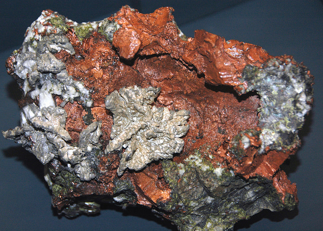
“The remarkable copper-silver ‘halfbreed’ specimen shown above comes from northern Michigan’s Portage Lake Volcanic Series, an extremely thick, Precambrian-aged, flood-basalt deposit that fills up an ancient continental rift valley.”
~ Creative Commons from James St. John
That the region, as before said, is rich in copper and silver ores, cannot be denied. And I think the indications that veins may or do exist somewhere in great richness, are sufficiently evident to justify continued explorations in search of them, by those who have the means and leisure to follow them up for several years. To find the veins, and most permanent deposites, must be the work of time; and as the season is short, on Lake Superior, for such operations, several years may be necessary before a proper and practical examination can be made of the country.
The general features of Lake Superior are very striking, and differ very much in appearance from what I have ever met with in any other part of the continent. The vastness and depth of such a body of pure fresh cold water so far within the continent, is an interesting characteristic. When we consider it is over 900 feet deep, with an area of over 30,000 square miles, and yet that, throughout its whole extent, it presents as pure and as fresh-tasted water as though it were taken from a mountain brook, the question naturally arises, Where can such a vast supply of pure water come from? It is true, it has great many streams flowing into it, but they are nearly all quite small, and would seem to be wholly inadequate to supply such a vast mass of water, and preserve it in such a state of purity. The water supplied by most of the rivers is far less pure than that in the lake itself. East of Keweena point, we found the water of the rivers discolored, being tinged by pine and other roots, clay, &c., often resembling the hue of New England rum. Such rivers, or all combined, would seem to be inadequate to supply such a vast quantity of pure clear water as fills this inland ocean!
~ United States Geological Survey
It is possible that this great lake is freely supplied with water from subterranean springs opening into it from below. The river St. Mary’s also seems inadequate, from its size, to discharge as much water as comes into the lake from the rivers which it receives. In this case, evaporation may be so great as to diminish the water that would otherwise pass out at it.
As relates to tides in the other lakes, we have nothing to say; but, as far as Lake Superior is concerned, we feel assured, from observation, as well as from the reports of others upon whom we can rely, that there are tides in it – variously estimated at from 8 to 12 inches; influenced, we imagine, by the point of observation, and the season of the year at which such tides are noticed.
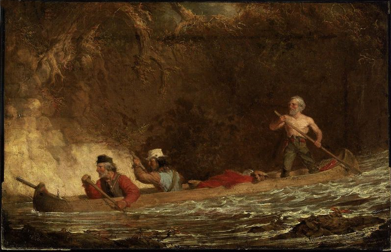
The Voyageurs (1846) by Charles Deas.
~ Commons.Wikimedia.org
What strikes the voyageur with the most interest, in the way of scenery, is the wild, high, bold, and precipitous coast of the southern shore, for such much of the whole distance between Grand Sable and La Pointe, and, indeed, for some distance beyond La Pointe ; the picturesque appearance of which often seemed heightened to us, as on a clear morning, or late afternoon, or voyageurs would conduct our boat for miles near their bases. Above us, the cliffs would rise in towering heights, while the bald eagle would be soaring in grand circular flights above their summits; our voyageurs, at the same time, chanting in chorus many of their wildest boat songs, as we glided along on the smooth and silent bosom of the lake. I have heard songs among various nations, and in various parts of the world; but, whether it was the wild scenery resting in solemn grandeur before me, with the ocean-like waste of water around us, which lent wilderness to the song, I never listened to any which appeared to sing a verse in solo, and then repeat a chorus, in which the whole crew would join. This would often be continued for several miles at a time, as the boat glided forward over smooth water, or danced along over the gentle swells of a moderate sea; the voyageurs, at the same moment, keeping time with their oars.
Jean Baptiste, our pilot, had an excellent voice, full, loud, and strong. He generally led off, in singing; the others falling in at the choruses. All their songs were in French, sometimes sentimental or pathetic, sometimes comic, and occasionally extempore, made, as sung, from the occurrences of the preceding day, or suggested by passing scenes.
The Chippewa Indians are poor singers; yet they have songs (such as they are) among them; one of which is a monotonous air repeated at their moccasin games.
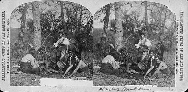
Stereographic view of a moccasin game, by J. H. Hamilton, 1880.
~ University of Minnesota Duluth
Next to the love of liquor, many of the Indians have a most unconquerable passion for gambling. While at La Pointe, I had an opportunity of seeing them play their celebrated moccasin game. They were to the number of two, or three aside, seated on the ground opposite to each other, which a blanket spread out between them, on which were placed four or five moccasins. The had two lead bullets, one of which was made rough, while the other remained smooth. Two f the gamesters were quite young men, with their faces painted with broad horizontal red and blue stripes, their eyelashes at the same time being dyed of a dark color. They played the game, won and lost, with as much sang froid as old and experienced gamblers. Those who sat opposite, especially one of them, was much older, but no means a match, at the time of my visit, for the young rascals, his antagonists. One takes the balls in his hands, keeps his eye directly on the countenance of the opposite party, at the same time tossing the balls in his hands, and singing, in a changing voice, words which sound somewhat like “He-he-hy-er-he-he-hy-er-haw-haw-haw-yer. He-he-hy-er,” &c. During which he keeps raising, shifting, and putting down the moccasins, till, finally, he raises his hands, having succeeded in concealing the balls under two of the moccasins, for which the other proceeds to search; and if he succeeds, on the first trial, in finding the rough ball, he wins. Then he takes the balls to hide, and commences singing himself. If he fails, he loses; and the first party repeats the song and the secretion of the balls. They hold in their hands small bundles of splinters of wood. When one loses, he gives to the winner so many sticks of wood. A certain number of them gained by any one of the party, wins the game. When I saw them, they had staked up their beads, belts, garters, knife-cases, &c. Their love of gaming is so strong, as to cause them to bet and lose everything they possess in the world – often stripping the last blanket from their naked backs, to stake on the game. It is said that some Indians acquire so much dexterity at this game, that others addicted to it refuse to play with them. In playing the game, they keep up a close watch on each other’s eyes, as being the best index to the movement of the hands. The song is repeated, no doubt, to diver the attention of the antagonists.
Among other peculiarities of Lake Superior, and one of its greatest recommendations, is the abundance and superiority of its fish, consisting of trout of large size, white fish, siskomit, ( a species of salmon,) and bass. The trout and siskomit are the finest and noblest fresh-water fish I ever saw. Almost every day we could catch trout by trailing a hook and line in the water behind out boat. In this way we caught one fine siskomit. Its meat, when fresh-cooked, we found about the color of salmon. The fish itself is about as heavy as a common-sized salmon, but less flat, being more round in form.

Detail of “The 12 Apostles” from Captain Jonathan Carver’s journal of his travels with maps and drawings, 1766.
~ Boston Public Library
If you will look at a map of Lake Superior, you will find, near its upper end, a labyrinth of islands, called by the early French voyageurs, of whom P. Charlevoix was one, (a Jesuit,) “the Madelaine islands.” They are sometimes called “the Twelve Apostles.” The largest island is now generally known as “the Madelaine island” – being the largest of the group. Just inside, and near its southern extremity, at the head of a large, regular bay, with a sandy beach, with an open and gently-rising scattered pine and spruce land in the rear of the beach, stands La Pointe – one of the most pleasant, beautiful, and desirable places for a residence on Lake Superior, and the very place where Fort Wilkins should have been placed, instead of its present location, which must be conceded, by every impartial person, to be among the very worst that could have been selected on the whole lake.
The garrison at Copper harbor, located, as it is, upon the rocky surface of trap conglomerate, affording a surface so scantily supplied with soil amidst masses of pebbly rock and trap fragments as to be wholly unfit for any sort of cultivation whatever, is altogether out of place. It is wholly inaccessible by land, and can only be reached by water in summer. It is at a spot where Indians usually never passed within forty miles of it, till since its occupation.
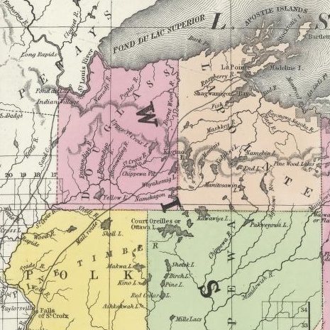
Detail of the Indian trail or “mail route” between La Pointe and St. Anthony Falls.
~ A new map of the State of Wisconsin, by Thomas, Cowperthwait & Co., 1850
The very next Congress should direct its prompt removal to La Pointe. Here, from the foot of the bay in front of the Madelaine island, there is an Indian trail, connecting La Pointe with St. Anthony’s Falls, and over which the mail is carried in winter by voyageurs on foot. La Pointe is the favorite resort of the Indians. Their lodges, in villages, bark canoes, &c. are found here the year round.
They delight to paddle and sail their canoes about the beautiful bays, harbors, &c. of these islands, employing their time in canoe building, hunting, fishing, &c. At every annual payment of their annuities, they flock to La Pointe in great numbers. Not only is that section of the great Chippewa nation sharing in the annuities brought together, but large parties of the same tribe, who receive no annuity, come at the same time from the British possessions to the north of Pigeon river. The Chippewas, called the “Pillageurs,” (so called from their thievish propensities,) inhabiting the country about Mille and Leech lakes, also attend – to meet relations, to traffic , and, perhaps, to steal a little. The great advantage of a government outpost is felt in the moral effect it exercises over the Indians. I know of no place where this influence would be more decidedly and beneficially exerted than at La Pointe. here should be daily unfurled the “stars and stripes,” and the sound of the evening gun be heard over the beautiful bays, and along the shores of the Twelve Apostles, which the Indians would learn to reverence with little less respect than they do the voice of the Manitou – the guardian spirit of the mines, embowelled in the dark trap hills of the lake.
Here, too, is an exceedingly healthy place, a good soil, and every convenience for raising the finest potatoes, turnips, and every kind of garden stuff.

1856 oil painting of Doctor Charles William Wulff Borup, a native of Copenhagen, Denmark. Borup married Elizabeth Beaulieu, a Lake Superior Chippewa daughter of Bazil Hudon Beaulieu and Ogimaagizzhigokwe. Borup and his brothers-in-law Charles Henry Oakes and Clement Hudon Beaulieu were co-signers of the 1842 Treaty with the Chippewa at La Pointe. Borup and Oakes became the first bankers of Minnesota.
Dr. Borup, the agent for the American Fur Company, (who have an extensive trading-post at this place,) has a superb garden. In walking through it with him, I saw very fine crops of the usual garden vegetables growing in it. His red currant bushes were literally bent down beneath their weight of ripe fruit. His cherry-trees had also borne well. Gooseberries also succeed well. The doctor also had some young apple-trees, that were in a thriving condition. Poultry, likewise, does well. Mrs. B. had her yard well stocked with turkeys, geese, ducks, and chickens. There was also a good garden at the mission-house of the American board.
However infinitely better is such a place for a United States garrison than Copper harbor, located, as it were, on a barren rock, where no Indians are seen, unless induced to go there by the whites – where there is nothing to protect – where intercourse is cut off in winter, and food can only reach it in summer – where there is no soil on which to raise a potato or a cabbage. I can only say that a greater blunder, in the location of a military post, was probably never committed. And if made (of which I am assured it was not) by a military man, he ought to be court-martialed and cashiered.
The mouth of the Ontonagon river is a far better spot for the fort than Copper harbor. It has a good soil, and a beautiful site for a fort. Furthermore, the country between it and Fort Winnebago, on the Wisconsin river, is favorable to the construction of a military road, which ought, at no distant day, to be opened. Another road should be cut from Fort Snelling, near the falls of St. Anthony, to La Pointe. In cutting these roads, it would seem to me as if the United States soldiers themselves might be usefully employed.
~ FortWiki.com
While at Copper harbor, I frequently visited Fort Wilkins, in command of Captain Cleary, whom I consider in every way an ornament and an honor to the service. In the brief space of time he has been at this post, and with the slender materials at command afforded by the country, he has nevertheless succeeded in making an “oasis” in a wilderness. He has erected one of the neatest, most comfortable, and best-planned garrisons it has been my lot to enter on the western frontier. He keeps all in excellent condition. His men look clean, healthy, and active. He drills them daily, and keeps them under most excellent discipline. He seems to take both pleasure and ride in the service. He says he never has any difficulty with is soldiers while he can exclude ardent spirits from them, as he succeeds in doing here, notwithstanding the great number of visitors to Copper harbor this summer.
To all travellers who are interested in objects of leading curiosity, the character of the Indians they fall in with cannot fail to arrest a share of attention.
The Chippewas are the only Indians now met with from the Sault Ste. Marie and Mackinac, extending from thence west along the southern shore of Lake Superior, to Fond du Lac, and from thence, in the same direction, to the Mississippi river. Within the United States they extend over the country south from the British boundary, to the country low down on the St. Croix and Chippewa rivers. The same tribe extends from our boundary northwest of the lake, entirely around its northern shore on British territory, till they reach the Sault Ste. Marie, opposite the American shore. It is said this tribe, spread over such a vast tract of country, is a branch of the powerful race of the Algonquins. They are sometimes called O-jib-was. They do not exist as a consolidated nation, or strictly as a confederation of bands. The entire nation on both sides of the line is divided into a great number of bands, with a chief at the head of each, which not uncommonly go by his name, such as “Old Martin’s band,” “Hole in the Day’s band,” &c.
The chief’s son, especially if he exhibits the right qualities, is expected to succeed his father at the head of the band; but very frequently the honor is reached by usurpation. The whole nation, which widely differ in circumstances, according to the part of the country they inhabit, nevertheless all speak the Chippewa language, and have extensive connexion by marriage, &c. The bands inhabiting the southern shore of Lake Superior are by far the best of any others. Though polygamy still prevails among them, and especially among their chiefs, it is nevertheless said to be becoming less common, especially where they are much influenced by Catholic and other missions. While at La Pointe, an Indian wedding was consummated, being conducted according to the ceremonies of the Catholic church, and performed by the missionary priest of that persuasion stationed at the Pointe.
There is one trait of character possessed by the Chippewas, (if we except, perhaps, the band of “pillageurs,” who have a kind of “Bedouin Arab” reputation among their countrymen,) which, I am sorry to say, the whites do not possess in an equal degree – that is, “very great honesty.”
White men can travel among them with the most perfect safety as to life and property. I will venture to say, that a man may carry baskets filled with gold and silver, and set them down in Indian villages, or leave them lying where he likes, or go to sleep by them, with Indians encamped all around him, and not one cent will be touched. Such a thing as a house being broken open and robbed at a Chippewa Indian trading-post was never heard of – within between two and three years’ intercourse with them – in time of peace. Dr. Borup said he would not be afraid, if concealed to look on, to leave his store door open all night; and the fact alone of its being left open, might be made known to the Indians at the Pointe. He would expect to see no Indian enter the store, nor would he expect to lose anything; such was his confidence in their honesty!!
Last winter, flour at the Pointe rose to $40 per barrel. The poor Indians were nearly famished for bread, but were unable to purchase it at such a price. They knew the American Fur Company had a considerable lot in store, guarded by nothing stronger than a padlock, yet they never offered the least violence towards the company’s agents or store! Would white people have acted as honestly? The poor Indians, by nature honest, have too often known the whites by the wrongs inflicted upon them, which God can forgive, but time can never blot out! They are very superstitious, but not as basely and insanely so, but a great deal, as the Mormons, Millerites, and other moon-stricken sects among the whites. They believe in one Great and Good Spirit, or a Being who can at will inflict good or evil on mankind; and there’s an end of it. They often denominate the mysterious spirit of evil import the Manitou, making him to dwell in the wild hills, islands, grottoes, and caves of Lake Superior.
From these huge birds the Indians obtained their first knowledge of fire, which they kindled with fire-sticks. These mythical birds were the most powerful of the animal deities of the Indians of the woodlands and of the plains. When the weather was stormy they flew about high in the heavens. When they flapped their great wings, one heard the crashes of thunder, when they opened and closed their eyes flashes of lightning were seen. Some carried lakes of water on their backs, these slopped over and caused downpours of rain. Their arrows, or thunderbolts, were the eggs which they dropped in their flight. These shattered the rocks and set fire to the forests and prairies.
A Chippewa Indian hunter, who was carried away to his nest by a Thunderer, saved his life by killing one of the young birds and flying back to earth in its feathered hide.
In the Smoky Mountains, a wild and rugged region in the southwestern part of Bayfield County, was the home of Winneboujou (Nenebozho), the fabled hero of the Ojibwa Indians. This all-powerful manitou was a blacksmith, and had his forge on the flat top of the highest mountain. Here he shaped the native copper of the Lake Superior region into useful implements for his Indian children. Much of his work at his forge was done at night, and the ringing blows of his great hammer could be heard throughout the Brule Valley and Lake Superior region. The fire of his forge reddened the sky. When he was not busy at his forge he was away hunting or seeking other adventures. Many stories of the exploits of this giant manitou have been told by the Chippewa and other Wisconsin Algonquian tribes.”
~ Legends of the Hills of Wisconsin by Dorothy Moulding Brown; The Wisconsin Archaeologist, Volume 18, Number 1, 1937, pages 20-21.
At times, it is said, a peculiar noise issues from the Porcupine mountains, and from the high hills on the main land, both east and west of La Pointe, some distance off. It is said to resemble the distant discharge of ordnance, or thunder. At one time, they said it was so loud and frequent, that they mistook it for signal guns fired from the brig Astor, which they thought might be in distress, and actually sent out a boat in search of her.
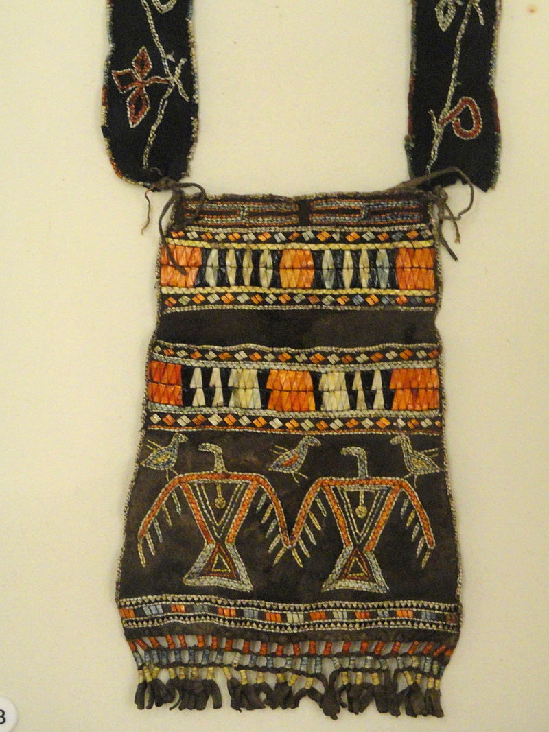
“Ojibwe shoulder pouch depicting two thunderbirds in quillwork, Peabody Museum, Harvard University.”
~ Commons.Wikimedia.org
These sounds the Indians believe to be the voice of the spirit “Manitou,” who guards the deposites of mineral wealth embowelled beneath the hills, and to whom any attempt made to dig them up, and carry them off, would be highly offensive, and followed by some kind of punishment. I have never yet heard of an Indian’s leading a white man to a locality of copper, or telling where he has found a piece when picked up!
Some have supposed that the noise in question arises from volcanic action; but, as no vibration is felt in the earth, and no other proof exists of such being the case, we are led to believe that the noise is produced by the lashing of the waves of the lake after a storm, as they are driven forward into the grottoes, caves, &c. of the tall sandstone cliffs, formed at their bases by the disintegrating effects of water and ice. Some distance east of La Pointe, about the Little Girl’s Point and Montreal river, as well as west of the same place, some fifteen or twenty miles, high red sandstone cliffs occur. At their bases, near the water’s edge, a great many curiously-shaped caves and grottoes appeared. In places, the sandstone had been so cut away, that only pillars remained standing at some ten or fifteen feet in the lake, from the top of which a high rude arch would extend to the main shore, and beneath which boats could easily pass. This was particularly the case near where the islands are parted with going west up the southern shore of the lake. Some caves, with small openings for mouths, run for a long distance back beneath the hills, expanding, likely, into large halls with high vaulted roofs, &c. After a storm, a heavy sea continues to roll into these grottoes and caverns, the waves lashing themselves against their sides and roofs – thus producing sounds resembling those heard at La Pointe, &c.
As the weather is generally calm after a storm, before the sea goes down, it is likely at such times these sounds are heard.
We had occasion to pass these places when a considerable sea would be on, close to the cliffs, and could hear the hollow heavy sounds of the waves as they broke into the caverns within the cliffs and hills. Every day, while we remained, parties of Indians continued to arrive, to be present at the payment.
We finally became prepared to leave for the Mississippi, having bought two bark canoes, and hired four new voyageurs – two for each canoe – one Indian, one half-breed, and two descendants of Canadian French; and, with a stock of provisions, we were ready to be off. From this place, I sent back three voyageurs to the Sault Ste. Marie, all that I hired to come as far as La Pointe. So, after paying our respects to Mr. Hays, our worthy Indian agent, and to Dr. Borup, (to both of whom I had borne letters of introduction,) and having many “bon voyages” heaped upon us by our friends and the friends of the voyageurs, we bade adieu to La Pointe.
You will not hear from me again till I reach the Falls of St. Croix.
I am yours, very truly, &c.
MORGAN.
To be continued in Saint Croix Falls…
John Johnston Describes La Pointe (1807-09)
June 12, 2014

Susan Johnston, or Ozhaawashkodewekwe, the wife of John Johnston ( Chicago Newberry Library)
The name of John Johnston will be familiar to those who have read the works of his son-in-law Henry Schoolcraft. Johnston (1762-1828) was born into the Anglo-Protestant gentry of Northern Ireland and came to the Chequamegon region in 1791. After marrying Ozhaawashkodewekwe, the daughter of Waabojiig, he cemented his alliance with a prominent Ojibwe trading family. The Johnstons settled at Sault Ste. Marie, and their influence as a fur-trade power couple in the eastern part of Lake Superior parallels that of Michel and Madeline (Ikwezewe) Cadotte around La Pointe. The Johnstons played a key role in resistance to American encroachment in Lake Superior during the War of 1812 but later became centrally-connected to the United States Government efforts to establish a foothold in the northern country. A nice concise biography of John Johnston is available in the Dictionary of Canadian Biography Online.

Roderick MacKenzie (Wikimedia Commons)
In 1806, John Johnston was trading at the Soo for the North West Company when he received a printed request from Roderick MacKenzie, one of the heads of the Company. It called for information on the physical and cultural geography of the different parts of North America where the NWC traded. Johnston took it upon himself to describe the Lake Superior region and prepared An Account of Lake Superior, an 82-page manuscript.
By the end of the 19th century, the manuscript had found its way to Louis Rodrigue Masson (a grandson-in-law of MacKenzie) who edited it and published it in Les Bourgeois de la Compagnie du Nord-Ouest; recits de voyages, lettres et rapports inedits relatifs au Nord-Ouest Canadien (1889-90). The Masson archives were later donated to the McGill University Library in Montreal and are now digitized.
Much of Johnston’s account concerns the Sault and the eastern part of Lake Superior. However, he does include some information from his time at La Pointe, which is reproduced below. While it doesn’t say much about the political topics that I tend to focus on, this document is fascinating for its geographic toponyms and terminology, which is much more reflective of the 18th century than the 19th. Enjoy:
[Ojibwe names for geographic locations are taken from Gidakiiminaan: An Anishinaabe Atlas of the 1836 (Upper Michigan), 1837, and 1842 Treaty Ceded Territories (GLIFWC 2007)].
[pg. 49-56]
…The coast runs almost due West from the Kakewiching or Porcupine Mountain to the Montreal River a distance of fifteen leagues, and the beach is a shelving rock the same as the Mountain all the way with here and there a little gravelly strand. There is but one river, and that a very small one, from the Black to the Montreal River. This last takes its rise from the Wa[s]wagonnis or flambeau Lake about 80 leagues to the Southwest: it is one continued rapid from within ten leagues of its source, and a few hundred yards from the entrance has a fall of fifteen or twenty feet: – there are two high clay banks which distinguish the entrance. The lands tends to the Northwest and is a stiff clay for three leagues rent into deep gutters at short distances; it then gradually declines to a sandy beach for three leagues farther until you arrive at the Mouskissipi or bad river so called from its broad and shallow stream in which it is almost impossible to mount even an Indian Canoe.
It takes its rise from the Ottawa Lake about 125 leagues to the Westward: the Lake has its waters divided very partially as the chief part takes a southerly course and falls into the Mississipi and is called Ottawa River.
The Flambeau Lake has its waters also, the better part taking a southeasterly direction to the Mississipi and is called Ouisconsin or the medicine River. From the bad river the coast runs north four leagues to Chogowiminan or La Pointe; it is a fine strand all the way, behind which are sand hills covered with bent and sand cherry shrubs – and behind the hills there runs all the length a shallow bay which is a branch from the Bay of St Charles.
At Lapointe you are nearly opposite the Anse or Keegwagnan the distance I should conjecture to be twenty leagues in a straight line.
The Bay of St Charles runs southwest from La Pointe and is four leagues in depth and better than a league broad at the entrance. Opposite Lapointe to the Northeast is the Island of Montreal, one of the largest of those called the twelve Apostles. On the main land the Indians had once a Village amounting to 200 huts but since the Traders have multiplied, they no longer assemble at Netoungan or the sand beach, but remain in small bands near their hunting grounds. When you double the Point of Netoungan the coast tends nearly west and is composed of high rocky points of Basaltes with some freestone; there is one place in particular which is an humble imitation of the Portals but not near so high: it is about a leagues from La Pointe and is a projection from the highest mountain from Porcupine bay to fond du lac, a distance of more than 45 leagues. From the Summit of the Mountain; you can count twenty six Islands extending to the North and North east, Islands which has never been visited by the boldest Indians and lying out of the way of the N.W.Co’s Vessel: have a chance of never being better known. Of the Islands opposite La pointe ten or twelve have been visited by the Indians, some of which have a rich soil covered with oak and beech, and round all of them there is deep water and fine fishing for Trout. The Trout in this part of the Lake are equal to those of Mackinac in size & richness – I myself saw one taken off the Northeast end of Montreal Island that weighed fifty two Pounds. How many Islands this Archipelago actually contains will not be easily ascertained; but I take Carribou Island to be the eastern end of the chain. It lies a little to the Southward of the course of the Co’s Vessel, is about three miles round, has a flat shore and good anchorage, and is allowed to be half passage from Camanitiquia to St. Mary’s. However, no other land is seen from it by the Vessel; but that may be owing to the Islands being low and lying too much to the Southward of the course. It is to be observed this account of the number of Islands is upon Indian Authority, which though not the best, is still less apocryphal than that of the Canadians.
There are several rivers between Lapointe and Fond du Lac, the distance is allowed to be thirty leagues, and the breadth of the bay from a high Rocky point within a leagues of Netoungan to the roche deboute, or the upright rock, which is a lofty Mountain right opposite, cannot be less than twenty leagues.
The Metal River is within ten leagues of Fond du Lac; it is only remarkable from the Old Chief of Lapointe’s having once found a large piece of Silver ore in descending it. The Burnt river is three leagues to the Westward of Metal river; it issues from one of the Lakes of the little wild Oats Country about thirty leagues to the Southward, and is only navigable for small Canoes: it has several rapids and the Portages are dangerous, several of them lying along the edge of the river, and over precipices where one false step would be fatal. It empties itself into the Bay of Fond du Lac through a stiff Clay Bank which continues all along the shore until it joins the sands of Fond du Lac river.
About sixteen years ago, Wabogick, or the Whitefisher, the Chief of Lapointe, made his sugar on the skirt of a high mountain four days march from the entrance of the river to the south west, his eldest daughter then a girl of fourteen with a cousin of hers who was two or three years older, rambling one day up the eastern side of the Mountain came to a perpendicular Cliff, which exactly fronted the rising sun, and had an apparently artificial level before it, on which near the base of the Cliff they found a pieces of yellow metal as they called it, about eighteen inches long, a foot broad, and four inches thick; and perfectly Smooth: – it was so heavy that they could raise it with great difficulty: – after amusing themselves with examining it for some time, it occured to the eldest girl that it belonged to the Gitchi Manitou or the great spirit; upon which they abandoned the place with precipitation. As the Chipeways are not Idolators, it occurs to me that some of the Southern tribes must have once Migrated thus far to the North, and that the piece, either of copper or gold, is part of an alter dedicated to the sun. If my conjecture is right, the slab is most probably gold as the Mexicans have more of that Metal than they have of copper. I have often regretted the premature death of the Chief the same autumn that he told me the story, as he had promised to go and bring it to me if he recovered: and circumstances since have precluded my making any attempt to procure it.
The river of Fond du Lac is deep, wide and serpentine, but is only navigable for four or five leagues from its entrance. The Portages are many and different until you arrive at the sand Lake, where the tribe of Chipeways, called the Pillagers, reside. The furs from this country are the best assorted of any on the Continent; and the quantity would much increase were it possible to repress the mutual incursions of the Scieux and Chipeways, who caray on perpetual war. The tract of country lying between the two nations for near 150 leagues in length and from thirty to forty in breadth is only visited by stealth, and if peaceably hunted would be more productive than the richest mine of Peru…
[pg. 75-76]
…The wild Vine is not found at St Mary’s nor any where along the lake except at Lapointe, where however it is scarce. The wild Hop is very abundant at Lapointe but I do not recollect to have seen it elsewhere. There are three distinct species of Whortleberry. The blue or real whortleberry is by far the most wholesome and agreeable: the abundance of this fruit on the borders of Lake Superior is incredible; the Indians dry great quantities of them which they preserve during the winter, and which make an agreeable taste when repeatedly washed in warm water to take away the smoky taste from them. The black Whortleberry grows much higher than the blue; its seeds are very hard and astringent – the largest species the Indians call Hareberry; it grows to 2 or 3 feet high and bears a fruit as large as a cherry, but it is neither so agreeable nor so wholesome as either of the others…
 Poisson Blanc (whitefish), Broche (pike) and Truite Comune (Lake Trout) from the Codex Canadensis.
 (Photo: Wikimedia Images)
 This is all for now on John Johnston, but this document is a potential jumping-off point for several potential research topics. Look for an upcoming post on the meaning of “La Pointe” and “La Pointe Band.”
