Bishop Baraga Crosses Lake Superior
February 18, 2025
Collected & edited by Amorin Mello

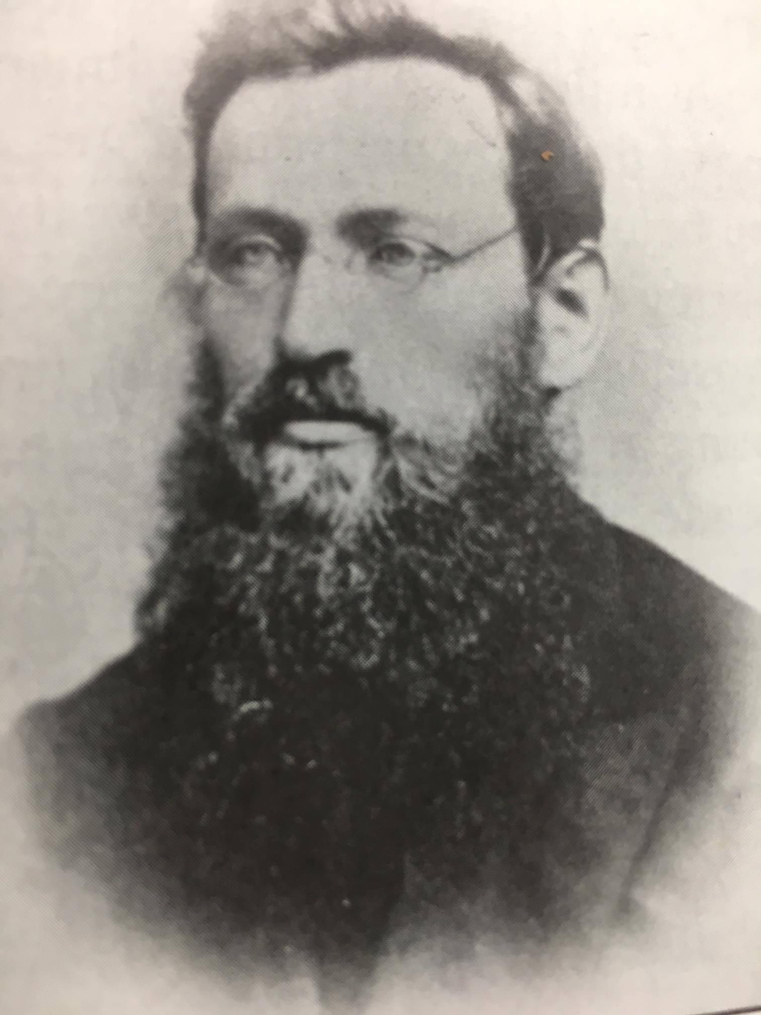
Bishop Irenaeus Frederic Baraga
~ Madeline Island Museum
This post features oral legends recorded about two of Bishop Irenaeus Frederick Baraga’s traverses from La Pointe across Lake Superior:
A) to Minnesota’s Cross River by canoe.
B) to Michigan’s Ontonagon River by ice.
In chronological order of publication, the first record was from a German traveloguer, the next two were from Catholic missionaries, and the last two were from Bad River tribal members.
- Kitchi-Gami, by Johann Georg Kohl, 1859/1860.
- Life and Labors of Bishop Baraga, by Rev. Chrysostom Verwyst, 1896.
- Life and Labors of Rt. Rev. Frederick Baraga, by Rev. Verwyst, 1900.
- Chippewa Indian Historical Project, by United States WPA, 1936-1942.
- Chippewa Indian Historical Project, by United States WPA, 1936-1942.

Originally published in German as
Kitschi-Gami; Oder, Erzählungen Vom Obern See
by Johann Georg Kohl, 1859.
Translated and republished in English as
Kitch-Gami: Wanderings Round Lake Superior,
By Johann Georg Kohl, 1860,
Pages 180-183.

German traveloguer
Johann Georg Kohl
Du Roy: “Do you known the summer voyage our most reverend friend, your companion, once made in a birch-bark canoe right across Lake Superior? Ah! that is a celebrated voyage, which everybody round the lake is acquainted with. Indeed, there is hardly a locality on the lake which is not connected with the history of his life, either because he built a chapel there, or wrote a pious book, or founded an Indian parish, or else underwent danger and adventures there, in which he felt that Heaven was protecting him.
“The aforesaid summer voyage, which I will tell you here as companion to his winter journey, was as follows:
“He was staying at that time on one of the Islands of the Apostles, and heard that his immediate presence was required at one of the little Indian missions or stations on the northern shore of the lake. As he is always ready to start at a moment, he walked with his breviary in his hand, dressed in his black robe, and with his gold cross fastened on his breast – he always travels in this solemn garb, on foot or on horseback, on show-shoes or in a canoe – he walked, I say, with his breviary in his hand and his three-corned hat on his head, into the hut of my cousin a well-known Voyageur, and said to him: ‘Dubois, I must cross the lake, direct from here to the northern shore. Hast thou a boat ready?’
” ‘My boat is here,’ said my cousin, ‘but how can I venture to go with you straight across the lake? It is seventy miles, and the weather does not look very promising. No one ever yet attempted this “traverse” in small boats. Our passage to the north shore is made along the coast, and we usually employ eight days in it.’
” ‘Dubois, that is too long; it cannot be. I repeat it to thee. I am called. I must go straight across the lake. Take thy paddle and “couverte,” and come!’ And our reverend friend took his seat in the canoe, and waited patiently till my obedient cousin (who, I grant, opened his eyes very wide, and shook his head at times) packed up his traps, sprang after him and pushed the canoe on the lake.
“Now you are aware, monsieur, that we Indians and Voyageurs rarely make greater traverses across the lake than fifteen miles from cape to cape, so that we may be easily able to pull our boats ashore in the annoying caprices of our weather and water. A passage of twenty-five or thirty miles we call a ‘grand traverse,’ and one of seventy miles is a impossibility. Such a traverse was never made before, and only performed this once. My cousin, however, worked away obediently and cheerfully, and they were soon floating in their nutshell in the middle of the lake like a loon, without compass and out of sight of land. Very soon, too, they had bad weather.
“It began to grow stormy, and the water rose in high waves. My cousin remarked that he had prophesied this, but his pious, earnest passenger read on in his breviary quietly, and only now and then addressed a kind word of encouragement to my cousin, saying that he had not doubted his prophecy about the weather, but he replied to it that he was called across the lake, and God would guide them both to land.
“They toiled all night through the storm and waves, and, as the wind was fortunately with them, they moved along very rapidly, although their little bark danced like a feather on the waters. The next morning they sighted the opposite shore. But how? With a threatening front. Long rows of dark rocks on either side, and at their base a white stripe, the dashing surf of the terribly excited waves. There was no opening in there, no haven, no salvation.
” ‘We are lost, your reverence,’ my cousin said, ‘for it is impossible for me to keep the canoe balanced in those double and triple breakers; and a return is equally impossible, owing to the wind blowing so stiffly against us.’
” ‘Paddle on, dear Dubois – straight on. We must get through, and a way will offer itself.’
“My cousin shrugged his shoulder, made his last prayers, and paddled straight on, he hardly knew how. Already they heard the surf dashing near them; they could no longer understand what they said to each other, owing to the deafening noise, and my cousin slipped his couverte from his shoulders, so as to be ready for a swim, when, all at once, a dark spot opened out in the white edge of the surf, which soon widened. At the same time the violent heaving of the canoe relaxed, it glided on more tranquilly, and entered in perfect safety the broad mouth of a stream, which they had not seen in the distance, owing to the rocks that concealed it.
” ‘Did I not say, Dubois, that I was called across, that I must go, and that thou wouldst be saved with me? Let us pray!’ So the man of God spoke to the Voyageur after they had stepped ashore, and drawn their canoe comfortably on the beach. They then went into the forest, cut down a couple of trees, and erected a cross on the spot where they landed, as a sign of their gratitude.
“Then they went on their way to perform their other duties. Later, however, a rich merchant, a fur trader, came along the same road, and hearing of this traverse, which had become celebrated, he set his men to work, and erected at his own expense, on the same spot, but on a higher rock, a larger and more substantial cross, which now can be seen a long distance on the lake, and which the people call ‘the Cross of —–‘s Traverse.’”

Historical Collections and Researches of Michigan Pioneer and Historical Society: Vol. XXVI,
by Michigan State Historical Society, 1896,
pages 541-542.
LIFE AND LABORS OF BISHOP BARAGA
A short sketch of the life and labors of Bishop Baraga
The Great Indian Apostle of the Northwest.
By Rev. Chrysostom Verwyst O.S.F. of Ashland, Wis.
Father John Chebul arrived on Lake Superior at the Sault in October 1859 to assist his fellow Slovanian Bishop Baraga. Chebul spent the winter at Ontonagon with miners before arriving at La Pointe in May 1860.
On another occasion Father Baraga went to Ontonagon from La Pointe. We will relate the incident as told to the writer by Rev. John Cebul, of Newberry, Mich. He was well acquainted with Bishop Baraga, being a fellow countryman who had been sent to La Pointe in 1860, where he labored amongst the Chippewas of that island and Bayfield, Bad River Reserve, Superior and other places, for about thirteen years, being universally loved and esteemed by all. He says:
Bishop Baraga was intending to go on the ice to Ontonagon. He was accompanied by a man from the island. The reason they took to the ice was because it was much nearer and the walking a great deal better than on the main land. During March and April the ice on Lake Superior becomes honey-combed and rotten. If a strong wind blows, it cracks and moves from the shore if the wind blows from the land. Such fields of ice does not notice that he is in danger till he comes to the edge of the ice and then to his horror discovers a large expanse of open water between him and the mainland. Should the ice float out towards the middle of the lake or break up, he is lost. Father Baraga and his companion had traveled on the ice for some time, thinking all was right. All at once they came to the edge of the ice and saw it was impossible to reach land, as the wind had driven the ice from the shore out into the Lake. His companion became greatly alarmed. Father Baraga remained calm, praying, no doubt, fervently to Him who alone could save them. Finally the wind changed and drove the cake of ice on which they were floating to the shore. They landed at Cadotte point, about 20 or 30 miles from Ontonagon, having been carried by the wind on their ice raft about sixty miles. “See,” said the good priest to his companion, “we have traveled a great distance and yet have not labored.” It seems the good God wanted to save the saintly missionary a long and painful walk, by giving him a ride of sixty miles on a cake of ice.

Life and labors of Rt. Rev. Frederic Baraga
by P. Chrysostomus Verwyst, 1900,
pages 219-222.
“Louis Gaudin“ was one of several legendary children born to Jean Baptiste Gaudin, Sr. and Awenishen (a sister of Hole-in-the-day):
– Antoine Gordon
– Elizabeth (Gordon) Belanger
– Louison Gordon, Sr.
– Harriet (Gordon) Lemon
– John Baptiste Gordon, Jr.
– Angelique Gordon
– Joseph GordonLouison Gordon, Sr. (1814-1899) married Julia Brebant, whose sisters were married to Henry Bresette and Judge John W. Bell.Wizon is an objibwecized form of the francophone name Louison.
Undated photo from the Gordon Museum thought to be a brother of Antoine Gordon:
possibly Louis Gordon?

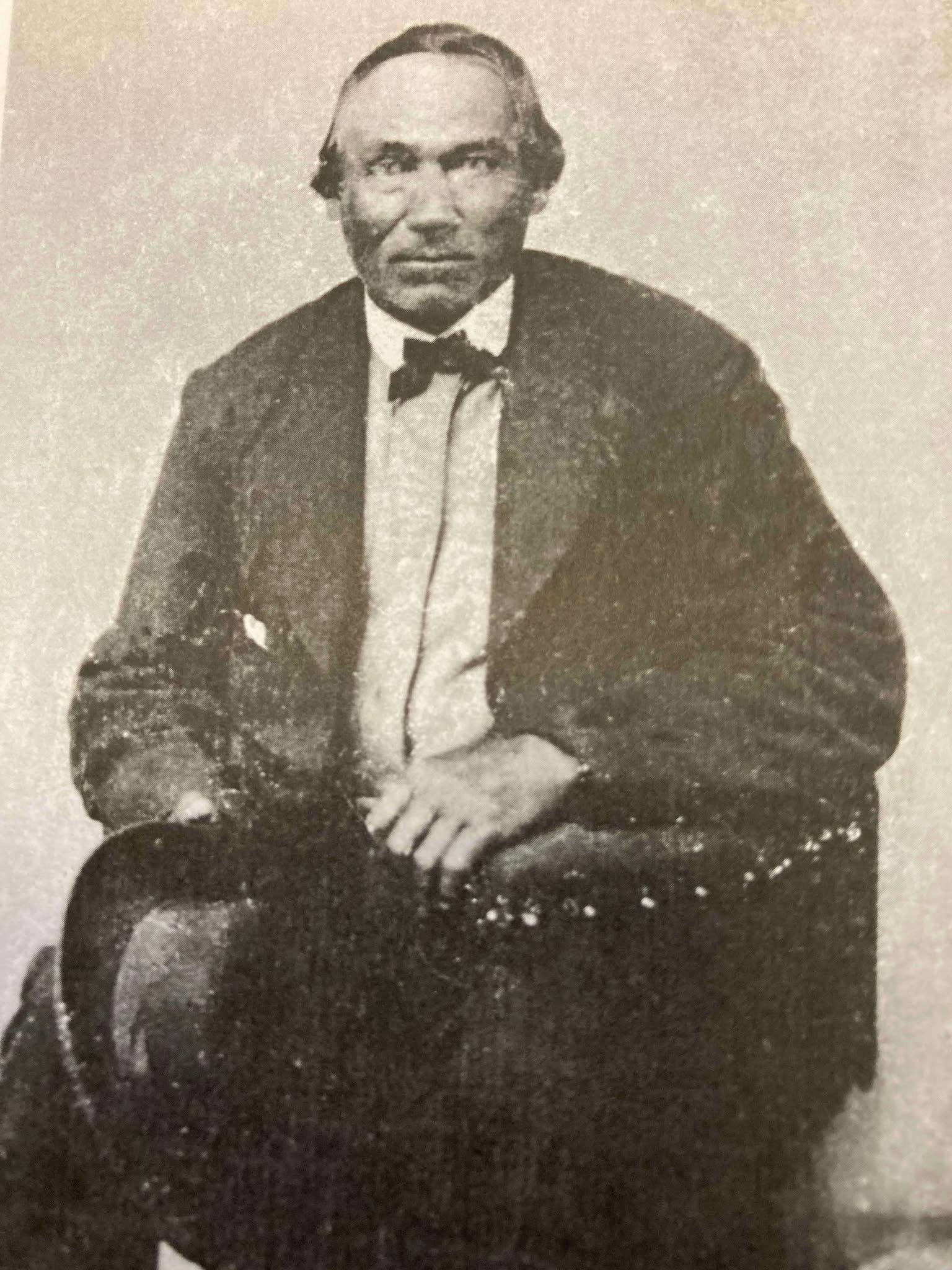
Chippewa Entrepreneur
Antoine Gordon
~ Noble Lives of a Noble Race (pg. 207) published by the St. Mary’s Industrial School in Odanah, 1909.
We learn from F. Baraga’s letter, written in October, 1845, that he intended to go to Grand Portage, Minn., the next fall to build a church there. It is, therefore, highly probable that he made that trip in the fall of 1846. He first went to La Pointe, where, no doubt, he spent some time attending to the spiritual wants of the good people. He then engaged a half-breed Indian, named Louis Gaudin, to go with him to Grand Portage. They had but a small fishing boat with a mast and sail, without keel or centre-board. Such a boat might do on a river or small lake, but would be very unsafe on a large lake, where it would easily founder or be driven lake a cork before the wind. The boat was but eighteen feet long. When they started from La Pointe, the people laughed at them for attempting to make the journey. They said it would take them a month to make the voyage, as they would have to keep close to the shore all the way, going first west some seventy miles to the end of the lake and then, doubling, turn northward, coasting along the northern shore of Lake Superior. this would make the distance about two hundred miles, perhaps even more.
However, Father Baraga and his guide set out on their perilous journey. At Sand Island they awaited a favorable wind to cross the lake, which is about forty miles wide at that place. By so doing they would save from eight to one hundred miles, but would expose themselves to great danger, as a high wind might arise, whilst they were out on the open lake, and engulf their frail bark.
They set sail on an unusually calm day. Father Baraga steered and Louis rowed the boat. Before they got midway a heavy west wind arose and the lake grew very rough. They were constantly driven leeward and when they finally reached the north shore they were at least thirty miles east of their intended landing place, having made a very perilous sail of seventy miles during that day.
While in the height of the storm, in mid-ocean, it might be said, Louis became frightened and exclaimed in Chippewa to the Father, who was lying on his back in the boat, reciting his office in an unconcerned manner: “Nosse, ki ga-nibomin, gananbatch” – Father, perhaps we are going to perish!” The Father answered quietly: “Kego segisiken, Wizon” (Chippewa for Louis) – “Don’t be afraid, Wizon; the priest will not die in the water. If he died here in the water the people on the other shore, whither we are going, would be unfortunate.”
When nearing the north shore the danger was even greater than out on the open water, for there were huge breakers ahead. Louis asked the Father whither to steer, and, as if following a certain inspiration, F. Baraga told him to steer straight ahead for the land. Through a special disposition of Divine Providence watching over the precious life of the saintly missionary, they passed through the breakers unharmed and ran their boat into the mouth of a small river, heretofore unnamed, but now called Cross River.
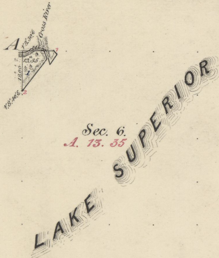
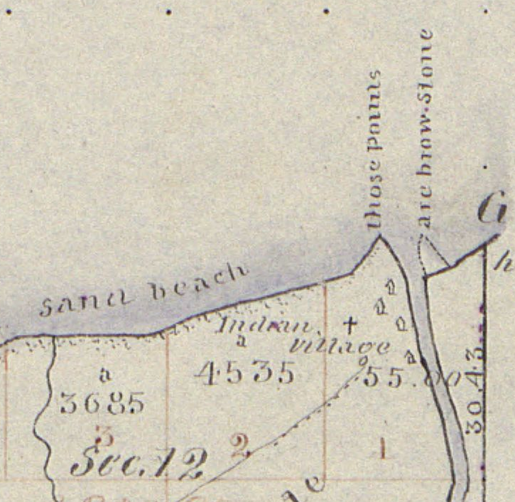
1859 PLSS detail of trees at the mouth of “Cross River”.
Full of gratitude for their miraculous escape, they at once proceeded to erect a cross. Hewing a tree in a rough manner, they cut off the top as far up as they could reach, and taking a shorter piece, they nailed it cross-wise to the tree. “Wizon,” said the Father, “let us make a cross here that the Christian Indians may know that the priest coming from La Pointe landed here.” The cross was, it is true, unartistic, but it was emblem of their holy faith and it gave the name, Tchibaiatigo-Sibi, “Cross River,” to the little stream where they landed.
They arrived none too soon. Ascending an eminence and looking out on the immense lake they saw that the storm was increasing every moment; high waves with white caps, which would surely have engulfed their little bark. They landed about six o’clock in the evening. Having spent the night there, they continued their journey next day, and in two days arrived at Grand Portage, having made the whole journey in three days. May we not think with Louis Gaudin that their safe passage across the stormy lake, and their deliverance from a watery grave, was due to a special intervention of Divine Providence in favor of the saintly missionary?

Missionary Labors of Fathers Marquette, Menard and Allouez, in the Lake Superior Region by Rev. Chrysostom Verwyst of Bayfield, 1886.
In 1667 Father Claude Allouez, S. J., then stationed at the mission of the Holy Ghost at the head of Chequamegon Bay, made the voyage across the lake from Sand Island. He made the voyage in a birch-canoe with three Indians. He remarks that they paddled their canoe all day as hard as they could without intermission, for fear of losing any of the beautiful calm weather they had. It took them twelve hours to make the trip across. The Father was then on his way to visit some Christian Indians residing at Lake Nipigon – “Animibigong” in Chippewa. For the particulars of this journey we refer the reader to “Missionary Labors of Fathers Marquette, Allouez, and Menard in the Lake Superior Region.”
The following narrative is not to be found in any of Baraga’s published letters, but the writers has it from the mouth of trustworthy persons, among whom is Father Chebul, a countryman of F. Baraga, who was stationed at Bayfield for many years. We will give the account, as we have it from Rev. F. Chebul.
Francois Newago, Sr. is the “man named Newagon” from Madeline Island, as his children were still young teenagers then.One time F. Baraga was going to Ontonagon in company with an Indian half-breed in the month of March or April. At that season of the year the ice, though thick, becomes honey-combed and rotten. Some say that Baraga’s companion was a man named Newagon. They went on the ice at La Pointe Island. As the walking on the sandy beach would have been very fatiguing and long, they determined to make straight for Ontonagon over the ice. By so doing they would not only have better walking, but also shorten their way a great deal.
A strong southwest wind was blowing at the time, and the ice, becoming detached from the shore, began drifting lakeward. After they had traveled for some time, they became aware of what hat happened, for they could see the blue waters between them and the shore. Newagon became greatly alarmed, for almost certain death stared them in the face. Had the wind continued blowing in the same direction, the ice would have been driven far out into the lake and broken up into small fragments. They would surely have perished.
To encourage the drooping spirit of his companion, F. Baraga kept telling him that they would escape all right and that they must trust in God, their loving Father and Protector. He also sang Chippewa hymns to divert Newagon’s attention and calm his excitement. Finally the wind shifted and blew the field of ice back towards the shore.
1847 PLSS detail of brownstone points, village, cross, and trailhead at the mouth of Iron River.
“Cadotte Point, near Union Bay“
appears to be located at what is now Silver City at the mouth of Iron River and eastern trailhead to the Porcupine Mountains.Michel Cadotte, Sr. ran a trading post by the Old French Fort on Madeline Island around 1800 and smaller stations scattered along the Wisconsin / Michigan shoreline of Lake Superior. Cadotte first worked for the British North West Company and later the American Fur Company after The War of 1812.They landed near Cadotte Point, near Union Bay, a short distance from Ontonagon, which they reached that same day. “See,” said the missionary to his companion, “we have traveled a great distance and have worked little.” The distance from La Pointe to Ontonagon is about sixty or seventy miles by an air line. Had they been obliged to walk the whole distance around the bend of the lake, it would probably have taken them two or three days of very hard and fatiguing traveling. So what at first seemed to threaten certain death was used by God’s fatherly providence to shorten and facilitate the saintly priest’s journey.
United States. Works Progress Administration:
Chippewa Indian Historical Project Records 1936-1942
(Northland Micro 5; Micro 532)
Reel 1, Envelop 3, Item 5
BISHOP BARAGA’S TRIP TO ONTONAGON
As related by William Obern to John Teeple.
Francois Belanger, Sr.
and Elizabeth (Gordon) Belanger. The Belanger Settlement was founded by their son Frank Belanger, Jr. and Elizabeth (Morrow) Belanger.
The journey I am about to describe is taken from the many experiences of Bishop Baraga, which were related to me by my grandfather. It deals with a journey made at an almost impossible time for ice travel on any of the Great Lakes, and portrays the important part the elements can play in a man’s life, for good or bad, for weal or for woe, as well as Bishop Baraga’s unfaltering confidence in Divine Providence.
The season of the year in which this incident took place was in the spring – along in April. Bishop Baraga and his faithful guide, Louis Gordon, started from LaPointe enroute to Ontonagon, Michigan, a distance of some eighty or ninety miles from LaPointe, straight across as the crow flies over the frozen water of Lake Superior. Dogs were used to a very large extent in those days for the purpose of transportation.
On account of the prevailing soft weather, the ice on the lake was not very solid, and with the right kind of wind, a general break-up was apt to occur at any time. In this instance, when the Bishop and his guide were about ten miles from LaPointe a south-west wind began to blow, increasing in velocity with each passing hour. The ice broke away from the shore, and began drifting outward into the open waters of Lake Superior, carrying its passengers with it. The guide, seeing the danger, suggested to the Bishop that they land on one of the islands, but the Bishop told him not to worry and to keep going in the direction of Ontonagon; that with the help of God they would reach their destination in safety.
With the coming of night the wind increased, and the two travelers were drifting out into the open waters with considerable speed. Soon the mainland was lost to view, and the guide knew that to remain on the ice mean ultimate death by freezing or drowning, but it was too late to do anything now. They had passed up the opportunity of getting off.
The missionary told Louis to look out for the dogs, and after taking a lunch, he wrapped himself up and went to sleep. He advised the guide to do likewise. The guide wrapped himself up, but he did not sleep. He kept constant vigil; about midnight the wind changed, coming from the opposite direction.

Detail of Porcupine Mountains, Iron River and Ontonagon River on the Map of the Mineral Lands Upon Lake Superior Ceded to the United States by the Treaty of 1842 With the Chippeway Indians, 1845.
The guide woke Bishop Baraga, telling him that the wind had changed. The priest asked his guide from what direction it was blowing, and upon being told that it was coming from the north-east remarked, “It is just what I hoped for and suspected.” He again told his guide to lie down and go to sleep, but the guide fearing that the plate of ice they were on might break up, would not sleep. They began to drift back almost in the same direction they had come, and when daylight came the outline of the Porcupine Mountains could be plainly seen in the distance. They were traveling at a very high rate of speed, and about mid afternoon they landed on the south shore of Lake Superior, one mile from Ontonagon, their destination.
“There,” said the bishop after they got off the ice and stepped on to the mainland, “this is just what I expected.”
At the time of this narrative, Ontonagon was a small settlement of Indians with but a few white men, who were engaged in the fur trade with the Indians and represented the American Fur Company.
* According to the description furnished by the guide, the piece of ice they were on was about one hundred by two hundred feet.
United States. Works Progress Administration:
Chippewa Indian Historical Project Records 1936-1942
(Northland Micro 5; Micro 532)
Reel 1, Envelop 3, Item 6
Cross River
ORIGIN OF THE NAME
Related by William Obern
To John Teeple.

Ojibwe, Activist, Priest
The Life of Father Philip Bergin Gordon, Tibishkogijik
by Tadeusz Lewandowski, 2019.
The story I am about to relate deals with an incident of one of the many experiences of Bishop Baraga. The narrative was related to me by my grandmother, Elizabeth Bellanger, who before her marriage was Elizabeth Gordon. She was a blood relative of Father Philip Gordon. The Gordon family consisted of the parents; sons, John, Louis and Antoine, and daughters My grandmother (Elizabeth) and Angelique.
Louis Gordon acted as the guide and all-around servant of Bishop Baraga, the missionary priest. The latter had a very large territory to cover; the northern and southern shores of Lake Superior, thence to the Dakotas and down to the waters known as Chippewa River, which emptied into the Mississippi below St. Paul.
Louis Gordon, the guide, (my grand-uncle) told of many of the experiences he had on these trips with Bishop Baraga. In speaking of my grand-uncle, Louis Gordon, I wish to state first, upon my honor as a gentleman, that he was a Christian in every sense of the word; he never took a drink of intoxicating liquor in his life; and never used profane language.
The stories related to me by my grandmother I well remember, and coming from a man like my grand-uncle, I believe them.
One day Bishop Baraga and his guide, Louis Gordon, started from LaPointe, on the western end of Lake Superior, near the place now known as Bayfield, on the shore of the lake, and about twenty-five miles from the present city of Ashland. At the time of this incident there were no white settlements to speak of at the western end of Lake Superior and the “head of the lakes” region. Bayfield, Washburn, Ashland, Superior and Duluth did not exist in those days. There were few white men among the Indians, and those few represented the American Fur Company. A few, mostly Frenchmen, had in former years settled in Minnesota and Wisconsin.
As formerly stated the trip started from LaPointe. It was to be made by water, and the boat used by the missionary and his guide, from the description given, could not have been more than 16 or 18 feet long. It was just large enough to accommodate the Bishop and his guide and to take care of their camping equipment, and although small, it came out the victor in many storms, proving itself quite seaworthy. These voyagers had a make-shift sail, which furnished them power when the wind was fair, probably a blanket which was raised on a pole; but in calm weather, or when the seas became too rough, the craft was usually propelled with oars. Wind and weather conditions in those days controlled lake travel largely, and when the lake became too rough and the seas too choppy, the voyageurs usually made a landing in some bay or stream outlet.
In this instance, the missionary and his guide were headed for Grand Marias, on the north shore of Lake Superior, a distance of fifty or fifty-five miles from the group of islands known as “Apostle Islands.” Leaving LaPointe, it was necessary for them to cross Lake Superior, traveling directly North. In the event of a severe storm, there is, of course, no place for shelter in the open waters of Lake Superior, and when once started it was necessary for them to continue their voyage until they reached Grand Marias, the point of their destination.
When the Bishop and his guide were about to leave the Apostle Islands, Louis Gordon, the guide, said to Bishop Baraga: “No-say,” (meaning father in Chippewa), “it would not be safe for us to cross the lake in this small boat today. The wind is from the south-west, and it is getting stronger. The lake will become very rough, the seas high, and I am afraid we may perish if we venture out in this wind. We had better not leave this island today, or else follow the south shore around to the end of the lake, so we can find a place to land should the seas become too rough.”
Bishop Baraga replied, “My son, have faith in God. Across that lake my Indians are waiting they must be expecting me, and it is my duty to get there as soon as possible. It would be a waste of time for us to go along the south shore, then along the north shore from the St. Louis River to Grand Marias, when we can cross here and save many miles of hard rowing and precious time. We will trust in God and make the crossing in safety.”
So, Louis Gordon, having unbounded faith in the Bishop, obeyed him, and they began their voyage across the lake, notwithstanding the fact that the wind was increasing in fury and the seas becoming higher and rougher with each passing moment. After they got into the open waters, the guide had considerable difficulty in manning the boat and keeping it from being swamped by the breaking seas. He stood up, and turning to Bishop Baraga said, “No-say, we will never reach the shore.” The Bishop was sitting at the stern of the boat, reciting his breviary. “Louis,” he said, “do not lose faith in God; fear not, He is with us.” The guide was kept busy in keeping the boat in its course, and bailing it out, to prevent it from being filled as the white caps would break over it. He headed it to a point west of Grand Marias in order that he might be better able to ride the crest of the seas, praying and hoping that when they reached the shore, which he hoped would be before dark, they would find a place to land in safety.
I wish to state here that I have seen the north shore of Lake Superior. After leaving Duluth, going east along the north shore, one will find a very rugged shore, ledges of rock from 20 to 200 feet in height standing perpendicularly along the shore line. In these rock ledges are great caves that have been fashioned by angry waves of Lake Superior during centuries. To fully appreciate this story it is well for the reader to know a little concerning the dangers of Lake Superior. Salt-water sailors who have been on the five oceans prefer to be on the ocean in a storm rather than on Lake Superior. The fact that Lake Superior is more dangerous than the oceans is conceded by sailors generally, particularly in the fall of the year. In the ocean, the billows are longer with great spaces between them; while on Lake Superior they are short, choppy, and heavy; and create much more hazard.
Night overtook the missionary and the guide before they reached the north shore; the wind became stronger and the billows higher. The only light they had to guide them was the distant glimmer of the stars, and the guide was able to keep his course by keeping his craft nosed in the direction of the North Star.
After many hours of hard pulling on the oars, the guide knew that they were reaching the shore because he was familiar with the shoreline, and knew that the noise which was all but deafening was created by the breakers dashing against the rock-bound shore.
The guide said to his companion, “No-say, we are nearing the shore, but I am sure we are many miles from Grand Marias. There is no river known in this region and on account of the precipitous formation of the shore line, we have no place to land in safety in this storm.” Bishop Baraga answered, “My son, do as I say, and we will make a landing in safety.” The guide obeyed. His hand were blistered; his strength was leaving his body, but he managed to keep up his struggle against the angry seas. The back-wash created by the billows dashing against the perpendicular rocks of the shore-line made conditions more perilous. The guide said, “Father, there is nothing but certain death ahead of us. We cannot survive this storm.” The noise was so great that it was impossible for the two voyagers to hear each other without shouting, though they were only fifteen or sixteen feet apart; but the Bishop simply said, “Louis, keep going straight ahead.”
Much water had entered their little boat, and it was coming in faster now that they were nearing the ledges of rocks, and the seas, augmented by the back-wash, were becoming rougher, so that destruction seemed imminent. Then amid the tumult and tossing of the boat upon the choppy seas, the boat was suddenly driven from the rough sea into tranquil waters, seemingly guided by some supernatural power. The guide knew that the craft was not being directed by his efforts, and that they were nearing the shore with each sweep of the waves. To his amazement, the boat grounded, and by feeling the depth of the water with his oar he knew that they were in shallow water, but he was unable to determine whether they were in a cave or at the mouth of some stream.
“Father,” Louis cried delightedly, “it seems to me that we are in a cave or at the mouth of some stream, because by feeling around with my oar I can feel a current coming from the land direction.” The missionary then told him to take out their bundle, and light the lantern so that they could see where they were and explore their surroundings.
After lighting the lantern, they made a survey of their surroundings and found that they were at the mouth of a large stream. They climbed out of the river and to higher ground, and there made their camp for the night.
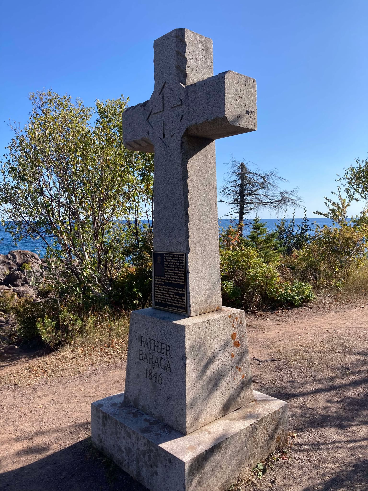
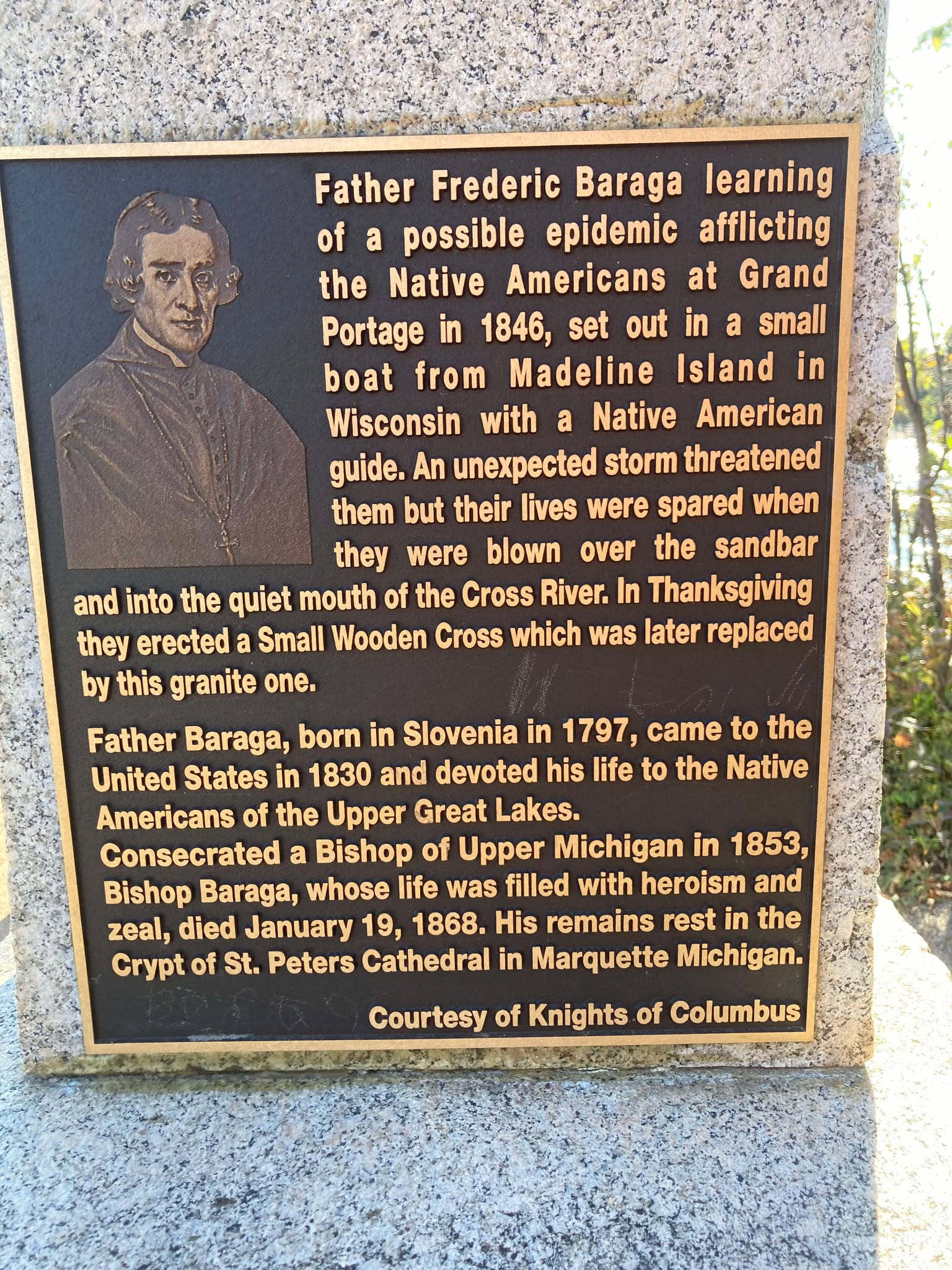
Cross River Historical Marker
Photo by Brian Finstad, 2024.
The following morning, Bishop Baraga told his guide that they would stay there that day, that they would construct and erect a cross in token of thanksgiving to God for his help and guidance to safety. So, all that day they worked. They cut down some large cedar trees and erected a large cedar cross, which they set up on the shore at the mouth of the stream. The next morning Bishop Baraga and his guide went down to the site of the cross they had erected, and again offered thanks to God for their safe deliverance. The missionary told his guide: “Hereafter this stream shall be known as “Cross River”. It has been thus known from that time on.
About twenty or twenty-five years ago, a large number of people from Duluth, Superior, and other towns and cities in the Lake Superior region, regardless of creed, made a trip to Cross River and erected a substantial cross there in place of the old cedar cross set up by Bishop Baraga and his guide, Louis Gordon, in thanksgiving to God for the wonderful guidance and loving care of his servants who landed safely at the mouth of this stream after such a perilous voyage.
Bishop Baraga stopped at Superior on their way back from the North Shore. They did not venture another lake-crossing. This zealous Lake Superior Chippewa Indian Missionary died at Marquette, Michigan, on January 19, 1868.
Cross River Historical Marker
Photo by Brian Finstad, 2024.
Bayfield’s Beginnings
March 6, 2016
By Amorin Mello
This is a reproduction of Captain Robinson Darling Pike’s speech for the 50th anniversary celebrations of Bayfield, Wisconsin on March 24th, 1906. It was originally digitized and reproduced onto RootsWeb.com by John Griener, a great-grandson of Currie G. Bell. The Bayfield County Press was in the Bell family from the Fall of 1882 until July of 1927. Pike’s obituary was not included in this reproduction.

Portrait of Bayfield from History of Northern Wisconsin, by the Western Historical Company, 1881, page 80.
Capt. R. D. PIKE on
Bayfield’s Beginnings
Captain Robinson Derling Pike
~ A gift that spawns Great Lakes fisheries:The legacy of Bayfield pioneer R.D. Pike, by Julia Riley, Darren Miller and Karl Scheidegger for the Wisconsin Department of Natural Resources, October 2011.
Robinson Darling PIKE, son of Judge Elisha and Elizabeth Kimmey PIKE, was a lumbering giant in early Bayfield history. Capt. R. D. Pike, as his name appeared weekly in the Press, was one of the most influential men in the county, associated not only with timber interests, but with the Bayfield Brownstone Company, the electric light company, the fish hatchery, etc. Just before his death on March 27, 1906, he wrote the following recollections of early Bayfield. The paper was read at the Bayfield 50th anniversary celebrations and was published in the March 30, 1906 issue of the Press along with Capt. PIKE’s obituary:
I regret very much not being able to be with you at the celebration of the fiftieth anniversary of the town of Bayfield. As you may be aware, I have been ill for the past few weeks, but am pleased to state at this time I am on the gain and hope to be among you soon. If my health permitted I would take great pleasure in being present with you this evening.
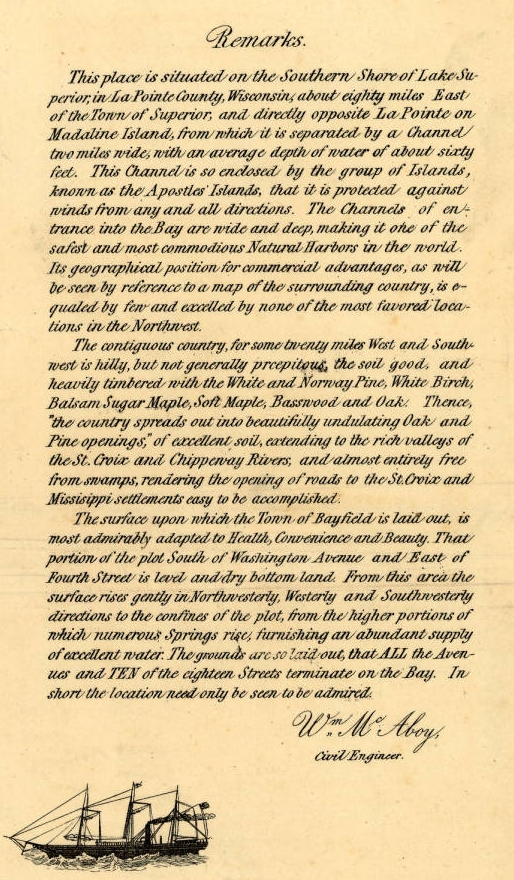
Detail from Major William McAboy‘s 1856 Map of Bayfield.
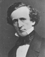
Senator Henry Mower Rice
~ United States Senate Historical Office
I remember very distinctly that the first stake was driven in the town of Bayfield by Major McABOY who was employed by the Bayfield Townsite Company to make a survey and plat same, (the original plat being recorded at our county seat.) This Bayfield Townsite Company was organized with Hon. Henry M. RICE of St. Paul at the head and some very enterprising men from Washington D.C. Major McABOY arrived here about the first of March and made his headquarters with Julius AUSTRIAN of LaPointe. Julius AUSTRIAN in those days being the Governor General of all that part of the country west of Ontonagon to Superior; Ashland and Duluth being too small to count The major spent probably two weeks at LaPointe going back and forth to Bayfield with a team of large bay horses owned by Julius AUSTRIAN, being the only team of horses in the country.
For more information about Julius Austrian, see other Austrian Papers.
I remember very well being in his office at LaPointe with father, (I being then a mere lad of seventeen,) and I recollect hearing them discuss with Mr. AUSTRIAN the question of running the streets in Bayfield north and south and avenues east and west, or whether they should run them diagonally due to the topography of the country, but he decided on the plan as the town is now laid out. Mr. AUSTRIAN and quite a little party from LaPointe came over here on the 24th of March, 1856, when they officially laid out the town, driving the first stake and deciding on the name Bayfield, named after Lieutenant Bayfield of the Royal Navy who was a particular friend of Senator RICE, and it was he who made the first chart for the guidance of boats on Lake Superior.

“Map of Bayfield situate in La Pointe County, Wisconsin” by Major William McAboy, 1856 for the Bayfield Land Company.
~ Wisconsin Historical Society

For more information about Indian interpreter Frederick Prentice, see his appearances in the Barber Papers.
~ Portrait of Prentice from History of the Maumee Valley by Horace S Knapp, 1872, pages 560-562.
The summer of 1855 father was in poor health, filled up with malaria from the swamps of Toledo, and he was advised by Mr. Frederick PRENTICE, now of New York, and known by everybody here as “the brownstone man,” to come up here and spend the summer as it was a great health resort, so father arrived at LaPointe in June, 1855, on a little steamer that ran from the Soo to the head of the lakes, the canal at that time not being open, but it was opened a little later in the season.

Detail of “Austrian’s Saw Mill” on Pike’s Creek, Chequamegon Bay, Lake Superior, circa 1852.
~ Wisconsin Public Land Survey Records
Upon arrival at LaPointe father entered into an agreement with Julius AUSTRIAN to come over to Pike’s creek and repair the little water mill that was built by the North American Fur Company, which at that time was owned by Julius AUSTRIAN. He made the necessary repairs on the little mill, caught plenty of brook trout and fell in love with the country on account of the good water and pure air and wrote home to us at Toledo glowing letters as to this section of the country. Finally he bought the mill and I think the price paid was $350 for the mill and forty acres of land, and that largely on time; however the mill was not a very extensive affair. Nearly everything was made of wood, except the saw and crank-pin, but it cut about two thousand feet of lumber in twelve hours. Some of the old shafting and pulleys can be seen in the debris at the old mill site now. Remember these were not iron shafts as we used wooden shafts and pulleys in those days. This class of the mill at the time beat whip-sawing, that being the usual way of sawing lumber.
Father left LaPointe some time in September 1855 for Toledo to move his family to Pike’s creek, which stream was named after we moved up here. Onion river and Sioux river were named before that time. On father’s arrival from Toledo from this country we immediately began to get ready to move. We had a large fine yoke of red oxen and logging trucks. He sold out our farm at Toledo, packed up our effects, and boarded a small steamer which took us to Detroit. Our family then consisted of father, mother, grandma PIKE, and my sister, now Mrs. BICKSLER, of Ashland. We stayed several days in Detroit to give father time to buy supplies for the winter; that is feed for the oxen and cow and groceries for the family to carry us through until Spring.
We then boarded the steamer Planet, which was a new boat operated by the Ward Line, considered the fastest on the lake. It was about two hundred fifty tons capacity. We came to Sault Ste. Marie, it being the Planet‘s first trip through the Soo, the canal as I remember was completed that fall. During this year the Lady Elgin was running from Chicago and the Planet and North Star running from Detroit, they being about the only boats which were classed better than sail boats of the one hundred and fifty tons.

Portrait of the Steamer North Star from American Steam Vessels, by Samuel Ward Stanton, page 40.
~ Wikimedia.org
We arrived at LaPointe the early part of October, 1855. On our way up we stopped at Marquette, Eagle Harbor, Eagle River, and Ontonagon. We left Ontonagon in the evening expecting to arrive at LaPointe early the next morning, but a fearful storm arose and the machinery of the Planet became disabled off Porcupine mountains and it looked for a while as though we were never going to weather the storm, but arrived at LaPointe the next day. There were some parties aboard for Superior who left LaPointe by sail.
We remained at LaPointe for a week or ten days on account of my mother’s health and then went to Pike’s bay with all our supplies, oxen and cow on what was known as the Uncle Robert MORRIN’s bateau. Uncle Robert and William MORRIN now of Bayfield, and if I remember rightly, each of the boys pulled an oar taking us across. We landed in Pike’s bay just before sundown, hitched up the oxen and drove to the old mill. Now, this was all in the fall of 1855.

Detail from William McAboy‘s 1856 Map of Bayfield.
“HON. JOHN W. BELL, retired, Madeline Island, P.O. La Pointe, was born in New York City, May 3, 1805, where he remained till he was eight years of age. His parents then took him to Canada, where his father died. He had gotten his education from his father and served an apprenticeship at three trades – watchingmaking, shipbuilding, and coopering. He then moved to Ft. La Prairie, and started a cooper shop, where he remained till 1835, when he came to La Pointe, on the brig “Astor,” in the employ of the American Furn Company as cooper, for whom he worked six months, when he took the business into his own hands, and continued to make barrels as late as 1870. It was in 1846 or 1847 that Robert Stewart, then Commissioner, granted him a license, and he opened a trading post at Island River, and became interested in the mines. he explored and struck a lead in the Porcupine Range, on Onion River, which he sold to the Boston Company, and then came back to La Pointe. In 1854 he was at the treaty between the Chippewas of Lake Superior and the Mississippi River, and was appointed Enrolling Agent on their new reservation, on the St. Louis River, where he went, but soon came back, as the Indians were not willing to stay there. He was then appointed by the Indians to look up their arrearages, and while at this work visited the national capital. He was appointed to County Judge for La Pointe County, and helt till 1878. He was elected on the town board in 1880. Has been Register of Deeds a great many years. Has held most all the different county and town offices, and at one time held or did principally the business for the whole county. He has seen La Pointe in all of its glory dwindle down to a little fishing hamlet; is now Postmaster at his island home, where he occupies a house put up by the old fur company. He was married in 1837 to Miss Margaret Brebant, in the old Catholic Church, by Rev. Bishop Baraga. They had seven children – John(deceased), Harriette (now Mrs. La Pointe), Thomas (deceased), Alfred (now Town Clerk), Sarah F., Margaret (deceased), and Mary (now Mrs. Denome).”
~ History of Northern Wisconsin, by the Western Historical Company, 1881.
As I said before, the town was laid out on March 24th, 1856, and record made same at LaPointe by John W. BELL, who at that time was the “Witte” of all the country between Ontonagon and Superior; Julius AUSTRIAN being the “Czar” of those days and both God’s noblemen. [Note: This was a reference to Count Sergei Witte and Tsar Nicholas II, contemporaries of Capt. Pike. Witte was responsible for much industrial development of Tsarist Russia in the 1890’s.] The Territory now comprising the town of Bayfield was taken from LaPointe county. There were a number of very prominent men interested in laying out the townsite and naming our avenues and streets, such as Hon. H. M. RICE and men of means from Washington after whom some of our avenues were named.
Very soon after this they wished to build a large mill in order to furnish lumber necessary for building up the town. The Washington people decided upon a man by the name of CAHO, an old lumberman of Virginia, so he was employed to come up here and direct the building of the mill. A hotel was built directly across from the courthouse by the Mr. BICKSLER who afterwards married my sister. The saw mill was built about a block west of where my saw mill now stands. The mill had a capacity of five or six thousand feet per day and I think the machinery came from Alexandria, Virginia. Joe LaPOINTE was the only man recognized as being capable of running a mill from the fact that he could do his own filing and sawing. While they were constructing the mill they had a gang of men in the woods getting out hard wood for fuel, not thinking of using any of the sawdust, and they piled the sawdust out with the slabs as useless. Charley DAY, whom many of you will remember, who was the party who got out the hardwood as fuel for the mill.
Time has wrought many changes in our midst. As far as I know, I am the only white man living who was here at the time the town was laid out.
In conclusion I wish to say that at a banquet given in Bayfield some two or three years ago, I made the statement that when the last pine tree was cut from the peninsula on which Bayfield is located the prosperity of our town and vicinity will have just commenced. The pine has gone and now we are cutting the hemlock and hardwood which will last ten to fifteen years; and long before this is exhausted the cut over lands will be taken up and farms tilled, as is the history of other sections of the country.

“Elisha and R.D. Pike owned a private fish hatchery [at Julius Austrian’s former sawmill] in Bayfield County from the 1860s to 1895. The Wisconsin State Legislature mandated the construction of a fish hatchery in northern Wisconsin in 1895, so R.D. Pike donated 405 acres (1.64 km2) from his hatchery to serve as the state hatchery. The state built the main hatchery building in 1897 using brownstone from nearby Pike’s Quarry. The Chicago, St. Paul, Minneapolis and Omaha Railway built a siding to the hatchery, and a special railcar known as The Badger brought fish from the hatchery to Wisconsin waterbodies. In 1974, new buildings and wells were constructed to modernize the hatchery. The hatchery was renamed in honor of longtime Wisconsin Department of Natural Resources secretary Les Voigt in 2006, and the main building was named for R.D. Pike in 2011. The hatchery currently spawns five types of trout and salmon and also includes a visitor’s center and aquarium.”
~ Wikipedia.org
CAUTION: This translation was made using Google Translate by someone who neither speaks nor reads German. It should not be considered accurate by scholarly standards.

Moritz Wagner (1813-1887) (Wikimedia Images)
Americans love travelogues. From de Tocqueville’s Democracy in America, to Twain’s Roughing It, to Steinbeck’s Travels with Charley, a few pages of a well-written travelogue by a random interloper can often help a reader picture a distant society more clearly than volumes of documents produced by actual members of the community. And while travel writers often misinterpret what they see, their works remain popular long into the future. When you think about it, this isn’t surprising. The genre is built on helping unfamiliar readers interpret a place that is different, whether by space or time, from the one they inhabit. The travel writer explains everything in a nice summary and doesn’t assume the reader knows the subject.
You can imagine, then, my excitement when I accidentally stumbled upon a largely-unknown and untranslated travelogue from 1852 that devotes several pages to to the greater Chequamegon region.
I was playing around on Google Books looking for variants of Chief Buffalo’s name from sources in the 1850s. Those of you who read regularly know that the 1850s were a decade of massive change in this area, and the subject of many of my posts. I was surprised to see one of the results come back in German. The passage clearly included the words Old Buffalo, Pezhickee, La Pointe, and Chippewa, but otherwise, nothing. I don’t speak any German, and I couldn’t decipher all the letters of the old German font.

Karl (Carl) Ritter von Scherzer (1821-1903) (Wikimedia Images)
The book was Reisen in Nordamerika in den Jahren 1852 und 1853 (Travels in North America in the years 1852 and 1853) by the Austrian travel writers Dr. Moritz Wagner and Dr. Carl Scherzer. These two men traveled throughout the world in the mid 19th-century and became well-known figures in Europe as writers, government officials, and scientists. In America, however, Reisen in Nordamerika never caught on. It rests in a handful of libraries, but as far as I can find, it has never been translated into English.
Chapter 21, From Ontonagon to the Mouth of the Bois-brule River, was the chapter I was most interested in. Over the course of a couple of weeks, I plugged paragraphs into Google Translate, about 50 pages worth.
Here is the result (with the caveat that it was e-translated, and I don’t actually know German). Normally I clog up my posts with analysis, but I prefer to let this one stand on its own. Enjoy:
XXI
From Ontonagon to the mouth of the Bois-brule River–Canoe ride to Magdalen Island–Porcupine Mountains–Camping in the open air–A dangerous canoe landing at night–A hospitable Jewish family–The island of La Pointe–The American Fur Company–The voyageurs or courriers de bois–Old Buffalo, the 90 year-old Chippewa chief–A schoolhouse and an examination–The Austrian Franciscan monk–Sunday mass and reflections on the Catholic missions–Continuing the journey by sail–Nous sommes degrades–A canoeman and apostle of temperance–Fond du lac–Sauvons-nous!
On September 15th, we were under a cloudless sky with the thermometer showing 37°F. In a birch canoe, we set out for Magdalene Island (La Pointe). Our intention was to drive up the great Lake Superior to its western end, then up the St. Louis and Savannah Rivers, to Sandy Lake on the eastern bank of the Mississippi River. Our crew consisted of a young Frenchman of noble birth and education and a captain of the U.S. Navy. Four French Canadians were the leaders of the canoes. Their trustworthy, cheerful, sprightly, and fearless natures carried us so bravely against the thundering waves, that they probably could have even rowed us across the river Styx.
Upon embarkation, an argument broke out between passengers and crew over the issue of overloading the boat. It was only conditioned to hold our many pieces of baggage and the provisions to be acquired along the way. However, our mercenary pilot produced several bags and packages, for which he could be well paid, by carrying them Madeline Island as freight.
Shortly after our exit, the weather hit us and a strong north wind obliged us to pull to shore and make Irish camp, after we had only covered four English miles to the Attacas (Cranberry) Rive,r one of the numerous mountain streams that pour into Lake Superior. We brought enough food from Ontonagon to provide for us for approximately 14 days of travel. The settlers of La Pointe, which is the last point on the lake where whites live, provided for themselves only scanty provisions. A heavy bag of ship’s biscuit was at the end of one canoe, and a second sack contained tea, sugar, flour, and some rice. A small basket contained our cooking and dining utensils.
The captain believed that all these supplies would be unecessary because the bush and fishing would provide us with the richest delicacies. But already in the next lunch hour, when we caught sight of no wild fowl, he said that we must prepare the rice. It was delicious with sugar. Dry wood was collected and a merry flickering fire prepared. An iron kettle hung from birch branches crossed akimbo, and the water soon boiled and evaporated. The sea air was fresh, and the sun shone brightly. The noise of the oncoming waves sounded like martial music to the unfinished ear, so we longed for the peaceful quiet lake. The shore was flat and sandy, but the main attraction of the scenery was in the gigantic forest trees and the richness of their leafy ornaments.
At a quarter to 3 o’clock, we left the bivouac as there was no more wind, and by 3 o’clock, with our camp still visible, the water became weaker and weaker and soon showed tree and cloud upon its smooth surface. We passed the Porcupine Mountains, a mountain range made of trapp geological formation. We observed that some years ago, a large number of inexperienced speculators sunk shafts and made a great number of investments in anticipation of a rich copper discovery. Now everything is destroyed and deserted and only the green arbor vitae remain on the steep trap rocks.
Our night was pretty and serene, so we went uninterrupted until 1 o’clock in the morning. Our experienced boatmen did not trust the deceptive smoothness of the lake, however, and they uttered repeated fears that storms would interrupt our trip. It happens quite often that people who travel in late autumn for pleasure or necessity from Ontonagon to Magdalene Island, 70 miles away, are by sea storms prevented from travelling that geographically-small route for as many as 6 or 8 days.
Used to the life of the Indians in the primeval forests, for whom even in places of civilization prefer the green carpet under the open sky to the soft rug and closed room, the elements could not dampen the emotion of the paddlers of the canoe or force out the pleasure of the chase.* But for Europeans, all sense of romantic adventure is gone when in such a forest for days without protection from the heavy rain and without shelter from the cold eeriness for his shivering limbs.
(*We were accompanied on our trip throughout the lakes of western Canada by half-Indians who had paternal European blood in their veins. Yet so often, a situation would allow us to spend a night inside rather than outdoors, but they always asked us to choose to Irish camp outside with the Indians, who lived at the various places. Although one spoke excellent English, and they were both drawn more to the great American race, they thought, felt, and spoke—Indian!)
It is amazing the carelessness with which the camp is set near the sparks of the crackling fire. An overwhelming calm is needed to prevent frequent accidents, or even loss of human life, from falling on the brands. As we were getting ready to continue our journey early in the morning, we found the front part of our tent riddled with a myriad of flickering sparks.
16 September (50° Fahrenheit)*) Black River, seven miles past Presque Isle. Gradually the shore area becomes rolling hills around Black River Mountain, which is about 100 feet in height. Frequently, immense masses of rock protrude along the banks and make a sudden landing impossible. This difficulty to reach shore, which can stretch for several miles long, is why a competent captain will only risk a daring canoe crossing on a fairly calm lake.
(*We checked the thermometer regularly every morning at 7 o’clock, and when travel conditions allowed it, at noon and evening.)
At Little Girl’s Point, a name linked to a romantic legend, we prepared lunch from the unfinished bread from the day before. We had rice, tea, and the remains of the bread we brought from a bakery in Ontonagon from our first days.
In the afternoon, we met at a distance a canoe with two Indians and a traveler going in an easterly direction. We got close enough to ask some short questions in telegraph style. We asked, “Where do you go? How is the water in the St. Louis and Savannah River?”
We were answered in the same brevity that they were from Crow Wing going to Ontonagon, and that the rivers were almost dried from a month-long lack of rain.
The last information was of utmost importance to us for it changed, all of a sudden, the fibers of our entire itinerary. With the state of the rivers, we would have to do most of the 300-mile long route on foot which neither the advanced season of the year, nor the sandy steppes invited. If we had been able to extend our trip, we could have visited Itasca Lake, the cradle of the Mississippi, where only a few historically-impressive researchers and travelers have passed near: Pike, Cass, Schoolcraft, Nicollet, and to our knowledge, no Austrian.
However, this was impossible considering our lack of necessary academic preparation and in consideration of the economy of our travel plan. We do not like the error, we would almost say vice, of so many travelers who rush in hasty discontent, supported by modern transport, through wonderful parts of creation without gaining any knowledge of the land’s physical history and the fate of its inhabitants.*
(*We were told here recently of such a German tourist who traveled through Mexico in only a fortnight– i.e. 6 days from Veracruz to the capital and 6 days back with only two days in the capital!)
While driving, the boatmen sang alternately. They were, for the most part, frivolous love songs and not of the least philological or ethnographic interest.
After 2 o’clock, we passed the rocks of the Montreal River. They run for about six miles with a long drag reaching up to an altitude of 100 feet. There are layers of shale and red sandstone, all of which run east to west. By weathering, they have obtained such a dyed-painting appearance, that you can see in their marbled colors something resembling a washed-out image.
The Montreal* is a major tributary of Lake Superior. About 300 steps up from where it empties into the lake, it forms a very pretty waterfall surrounded by an impressive pool. Rugged cliffs form the 80’ falls over a vertical sandstone layer and form a lovely valley. The width of the Montreal is 10’, and it also forms the border between the states of Michigan and Wisconsin.
(*Indian: Ka-wa’-si-gi-nong sepi, the white flowing falls.)
We stayed in this cute little bay for over an hour as our frail canoes had begun to take on a questionable amount of water as the result of some wicked stone wounds.
Up from Montreal River heading towards La Pointe, the earlier red sandstone formation starts again, and the rich shaded hills and rugged cliffs disappear suddenly. Around 6 o’clock, we rested for half an hour at the mouth of the Bad River of Lake Superior. We quickly prepared our evening snack as the possibility of reaching Magdalene Island that same night was still in contention.
Across from us, on the western shore of Bad River*, we saw Indians by a warm fire. One of the boatmen suspected they’d come back from catching fish, and he called in a loud voice across the river asking if they wanted to come over and sell us some. We took their response, and soon shy Indian women (squaws) appeared. Lacking a male, they dreaded to get involved in trading with Whites, and did not like the return we offered.
(*On Bad River, a Methodist Mission was founded in 1841. It consists of the missionary, his wife, and a female teacher. Their sphere of influence is limited to dispensing divine teaching only to those wandering tribes of Chippewa Indians that come here every year during the season of fishing, to divest the birch tree of its bark, and to build it into a shelter).
A part of our nightly trip was spent fantastically in blissful contemplation of the wonders above us and next to us. Night sent the cool fragrance of the forest to our lonely rocking boat, and the sky was studded with stars that sparkled through the green branches of the woods. Soon, luminous insects appeared on the tops of the trees in equally brilliant bouquets.
At 11 o’clock at night, we saw a magnificent aurora borealis, which left such a bright scent upon the dark blue sky. However, the theater soon changed scene, and a fierce south wind moved in incredibly fast. What had just been a quietly slumbering lake, as if inhabited by underwater ghosts, struck the alarm and suddenly tumultuous waves approached the boat. With the faster waves wanting to forestall the slower, a raging tumult arose resembling the dirt thrown up by great wagon wheels.
We were directly in the middle of that powerful watery surface, about one and one half miles from the mainland and from the nearest south bank of the island. It would have been of no advantage to reverse course as it required no more time to reach the island as to go back. At the outbreak of this dangerous storm, our boatmen were still determined to reach La Pointe.
But when several times the beating waves began to fill our boat from all sides with water, the situation became much more serious. As if to increase our misery, at almost the same moment a darkness concealed the sky and gloomy clouds veiled the stars and northern lights, and with them went our cheerful countenance.
Now singing, our boatmen spoke with anxious gestures and an unintelligible patois to our fellow traveler. The captain said jokingly, that they took counsel to see who should be thrown in the water first should the danger increase. We replied in a like manner that it was never our desire to be first and that we felt the captain should keep that honor. Fortunately, all our concern soon ended as we landed at La Pointe (Chegoimegon).
To be continued…
CAUTION: This translation was made using Google Translate by someone who neither speaks nor reads German. It should not be considered accurate by scholarly standards.
