1842 Treaty Speeches at La Pointe in the News
May 15, 2024
Collected by Amorin Mello & edited by Leo Filipczak

Green Bay Republican:
Saturday, November 5, 1842, Page 2.

Robert Stuart was a top official in Astor’s American Fur Company in the upper Great Lakes region. Apparently, it was not a conflict of interest for him to also be U.S. Commissioner for a treaty in which the Fur Company would be a major beneficiary.
A gentleman who has recently returned from a visit to the Lake Superior Indian country, has furnished us with the particulars of a Treaty lately negotiated at La Pointe, during his sojourn at that place, by ROBERT STUART, Esq., Commissioner of Indian Affairs for the district of Michigan, on the part of the United States, and by the Chiefs and Braves of the Chippeway Indian nation on their own behalf and their people. From 3 to 4000 Indians were present, and the scene presented an imposing appearance. The object of the Government was the purchase of the Chippeway country for its valuable minerals, and to adopt a policy which is practised by Great Britain, i.e. of keeping intercourse with these powerful neighbors from year to year by paying them annuities and cultivating their friendship. It is a peculiar trait in the Indian character of being very punctual in regard to the fulfillment of any contract into which they enter, and much dissatisfaction has arisen among the different tribes toward our Government, in consequence of not complying strictly to the obligations on their part to the Indians, in the time of making the payments, for they are not generally paid until after the time stipulated in the treaty, and which has too often proven to be the means of losing their confidence and friendship.
On the 30th of September last, Mr. Stuart opened the Council, standing himself and some of his friends under an awning prepared for the occasion, and the vast assembly of the warlike Chippeways occupying seats which were arranged for their accommodation. A keg of Tobacco was rolled out and opened as a present to the Indians, and was distributed among them; when Mr. Stuart addressed them as follows:-
The Passenger Pigeon (Ectopistes migratorius) was a metaphor for infinite abundance in 1842. In less than 75 years, the species would be extinct. What that means for Stuart’s metaphor is hard to say (Biodiversity Heritage Library).
The chiefs who had been to Washington were the St. Croix chiefs Noodin (pictured below) and Bizhiki. They were brought to the capital as part of a multi-tribal delegation in 1824, which among other things, toured American military facilities.I am very glad to meet and shake hands with so many of my old friends in good health; last winter I visited your Great Father in Washington, and talked with him about you. He knows you are poor and have but little for your women and children, and that your lands are poor. He pities your condition, and has sent me here to see what can be done for you; some of your Bands get money, goods, and provisions by former Treaty, others get none because the Great Council at Washington did not think your lands worth purchasing. By the treaty you made with Gov. Cass, several years ago, you gave to your lands all the minerals; so the minerals belong no longer to you, and the white men are asking him permission to take the minerals from the land. But your Great Father wishes to pay you something for your lands and minerals before he will allow it. He knows you are needy and can be made comfortable with goods, provisions, and tobacco, some Farmers, Carpenters to aid in building your houses, and Blacksmiths to mend your guns, traps, &c., and something for schools to learn your children to read and write, and not grow up in ignorance. I hear you have been unpleased about your Farmers and Blacksmiths. If there is anything wrong I wish you would tell me, and I will write all your complaints to your Great Father, who is ever watchful over your welfare. I fear you do not esteem your teachers who come among you, and the schools which are among you, as you ought. Some of you seem to think you can learn as formerly, but do you not see that the Great Spirit is changing things all around you. Once the whole land was owned by you and other Indian Nations. Now the white men have almost the whole country, and they are as numerous as the Pigeons in the spring. You who have been in Washington know this; but the poor Indians are dying off with the use of whiskey, while others are sent off across the Mississippi to make room for the white men. Not because the Great Spirit loves the white men more than the Indians, but because the white men are wise and send their children to school and attend to instructions, so as to know more than you do. They become wise and rich while you are poor and ignorant, but if you send your children to school they may become wise like the white men; they will also learn to worship the Great Spirit like the whites, and enjoy the prosperity they enjoy. I hope, and he, that you will open your ears and hearts to receive this advice, and you will soon get great light. But said he, I am afraid of you, I see but few of you go to listen to the Missionaries, who are now preaching here every night; they are anxious that you should hear the word of the Great Spirit and learn to be happy and wise, and to have peace among yourselves.
The 1837 Treaty of St. Peters was mostly negotiated by Maajigaabaw or “La Trappe” of Leech Lake and other chiefs from outside the territory ceded by that treaty. The chiefs from the ceded lands were given relatively few opportunities to speak. This created animosity between the Lake Superior and Mississippi Bands.Your Great Father is very sorry to learn that there are divisions among his red children. You cannot be happy in this way. Your Great Father hopes you will live in peace together, and not do wrong to your white neighbors, so that no reports will be made against you, or pay demanded for damages done by you. These things when they occur displease him very much, and I myself am ashamed of such things when I hear them. Your Great Father is determined to put a stop to them, and he looks that the Chiefs and Braves will help him, so that all the wicked may be brought to justice; then you can hold up your heads, and your Great Father will be proud of you. Can I tell him that he can depend upon his Chippeway children acting in this way.
One other thing, your Great Father is grieved that you drink whiskey, for it makes you sick, poor, and miserable, and takes away your senses. He is determined to punish those men who bring whiskey among you, and of this I will talk more at another time.
Stuart would become irritated after the treaty when the Ojibwe argued they did not cede Isle Royale in 1842. This lead to further negotiations and an addendum in 1844. The Grand Portage Band, who lived closest to Isle Royale, was not party to the 1842 negotiations.When I was in New York about three moons ago I found 800 blankets which were due you last year, which by some mismanagement you did not get. Your Great Father was very angry about it, and wished me to bring them to you, and they will be given you at the payment. He is determined to see that you shall have justice done you, and to dismiss all improper agents. He despises all who would do you wrong. Now I propose to buy your lands from Fond du Lac, at the head of Lake Superior, down Lake Superior to Chocolate River near Grand Island, including all the Islands in the limits of the United States, in the Lake, making the boundary on Lake Superior about 250 miles in extent, and extending back into the country on Lake Superior about 100 miles. Mr. Stuart showed the Chiefs the boundary on the map, and said you must not suppose that your Great Father is very anxious to buy your lands, the principal object is the minerals, as the white people will not want to make homes upon them. Until the lands are wanted you will be permitted to live upon them as you now do. They may be wanted hereafter, and in this event your Great Father does not wish to leave you without a home. I propose that the Fond du Lac lands and the Sandy Lake tract (which embrace a tract 150 miles long by 100 miles deep) be left you for a home for all the bands, as only a small part of the Fond du Lac lands are to be included in the present purchase. Think well on the subject and counsel among yourselves, but allow no black birds to disturb you, your Great Father is now willing and can do you great good if you will, but if not you must take the consequences. To-morrow at the fire of the gun you can come to the Council ground and tell me whether the proposal I make in the name of your Great Father is agreeable to you; if so I will do what I can for you, you have known me to be your friend for many years. I would not do you wrong if I could, but desire to assist you if you allow me to do so. If you now refuse it will be long before you have another offer.

October 1st. At the sound of the Cannon the Council met, and when all were ready for business, Shingoop, the head Chief of the Fond du Lac band, with his 2d and 3d Chiefs, came forward and shook hands with the Commissioner and others associated with him, then spoke as follows:
Zhingob (Balsam), also known as Nindibens, signed the 1837, 1842, and 1854 treaties as chief or head chief of Fond du Lac. The Zhingob on earlier treaties is his father. See Ely, ed. Schenck, The Ojibwe Journals of Edmund F. ElyNaagaanab (Foremost Sitter) is likely the 2nd Fond du Lac chief mentioned here.
My friend, we now know the purpose you came for and we don’t want to displease you. I am very glad there are so many Indians here to hear me. I wish to speak of the lands you want to buy of me. I don’t wish to displease the Traders. I don’t wish to displease the half-breeds; so I don’t wish to say at once, right off. I want to know what our Great Father will give us for them, then I will think and tell you what I think. You must not tell a lie, but tell us what our Great Father will give us for our lands. I want to ask you again, my Father. I want to see the writing, and who it is that gave our Great Father permission to take our minerals. I am well satisfied of what you said about Blacksmiths, Carpenters, Schools, Teachers, &c., as to what you said about whiskey, I cannot speak now. I do not know what the other Chiefs will say about it. I want to see the treaty and the name of the Chiefs who signed. The Chief answered that the Indians had been deceived, that they did not so understand it when they signed it.

Mr. Stuart replied that this was all talk for nothing, that the Government had a right to the minerals under former treaty, yet their Great Father wishes now to pay for the minerals and purchase their lands.
The Chief said he was satisfied. All shook hands again and the Chief retired.
The next Chief who came forward was the “Great Buffalo” Chief of the La Pointe band. Had heavy epaulettes on his shoulders and a hat trimmed with tinsel, with a heavy string of bear claws about his neck, and said:-
“Big Buffalo (Chippewa),” 1832-33 by Henry Inman, after J.O. Lewis (Smithsonian).
My father, I don’t speak for myself only, but for my Chiefs. What you said here yesterday when you called us your children, is what I speak about. I shall not say what the other Chief has said, that you have heard already.

He then made some remarks about the Missionaries who were laboring in their country and thought as yet, little had been done. About the Carpenters, he said, that he could not tell how it would work, as he had not tried it yet.
We have not decided yet about the Farmers, but we are pleased at your proposal about Blacksmiths. Can it be supposed that we can complete our deliberations in one night. We will think on the subject and decide as soon as we can.
The great Antonaugen Chief came next, observing the usual ceremony of shaking hands, and surrounded by his inferior Chiefs, said:-
The great Ontonagon Chief is almost certainly Okandikan (Buoy), depicted here in a reproduction of an 1848 pictograph carried to Washington and reproduced by Seth Eastman. Okandikan is depicted as his totem symbol, the eagle (largest, with wing extended in the center of the image).
My father and all the people listen and I call upon my Great Father in Heaven to bear witness to the rectitude of my intentions. It is now five years since we have listened to the Missionaries, yet I feel that we are but children as to our abilities. I will speak about the lands of our band, and wish to say what is just and honorable in relation to the subject. You said we are your children. We feel that we are still, most of us, in darkness, not able fully to comprehend all things on account of our ignorance. What you said about our becoming enlightened I am much pleased; you have thrown light on the subject into my mind, and I have found much delight and pleasure thereby. We now understand your proposition from our Great Father the President, and will now wait to hear what our Great Father will give us for our lands, then we will answer. This is for the Antannogens and Ance bands.

Mr. Stuart now said, that he came to treat with the whole Chippeway Nation and look upon them all as one Nation, and said
I am much pleased with those who have spoken; they are very fine orators; the only difficulty is, they do not seem to know whether they will sell their lands. If they have not made up their minds, we will put off the Council.
Lac du Flambeau Chief, “the Great Crow,” came forward with the strict Indian formalities but had but little to say, as he did not come expecting to have any part in the treaty, but wished to receive his payment and go home.
The 2d Chief of this band wished to speak. He was painted red with black spots on each cheek to set off his beauty, his forehead was painted blue, and when he came to speak, he said:-
What the last Chief has said is all I have to say. We will wait to hear what your proposals are and will answer at a proper time.
Next came forward “Noden,” or the “Great Wind,” Chief of the Mill Lac band, and said:-

Noodin (Wind) is mentioned here as representing the Mille Lacs Band, though his village was usually on Snake River of the St. Croix.
I have talked with my Great Father in Washington. It was a pity that I did not speak at the St. Peters treaty. My father, you said you had come to do justice. We do not wish to do injustice to our relations, the half-breeds, who are also our friends. I have a family and am in a hurry to get home, if my canoes get destroyed I shall have to go on foot. My father, I am hurry, I came for my payment. We have left our wives and children and they are impatient to have us return. We come a great distance and wish to do our business as soon as we can. I hope you will be as upright as our former agent. I am sorry not to see him seated with you. I fear it will not go as well as it would. I am hurry.
Mr Stuart now said that he considered them all one nation, and he wished to know whether they wished to sell their lands; until they gave this answer he could do nothing, and as it regards any thing further he could say nothing, and said they might now go away until Monday, at the firing of the Cannon they might come and tell him whether they would sell their country to their Great Father.
We intend giving the remainder of the proceedings of the treaty in our next.
Green Bay Republican:
SATURDAY, NOVEMBER 12, 1842, Page 2.
(Treaty with the Chippeways Concluded.)
Monday morning three guns were fired as a signal to open the Treaty. When all things were in readiness, Mr. Stuart said:
I am glad you have now had time for reflection, and I hope you are now ready like a band of brothers to answer the question which I have proposed. I want to see the Nation of one heart and of one mind.
Shingoop, Chief of the Fond du Lac band, came forward with full Indian ceremony, supported on each side by the inferior Chiefs. He addressed the Chippeway nation first, which was not fully interpreted; then he turned to the Commissioner and said:
in this Treaty which we are about to make, it is in my heart to say that I want our friends the traders, who have us in charge provided for. We want to provide also for our friends the half-breeds – we wish to state these preliminaries. Now we will talk of what you will give us for our country. There is a kind of justice to be done towards the traders and half-breeds. If you will do justice to us, we are ready to-morrow to sign the treaty and give up our lands. The 2d Chief of the band remarked, that he considered it the understanding that the half-breeds and traders were to be provided for.
The Great Buffalo, of La Pointe band, and his associate Chiefs came next, and the Buffalo said:
My Father, I want you to listen to what I say. You have heard what one Chief has said. I wish to say I am hurry on account of keeping so many men and women here away from their homes in this late season of the year, so I will say my answer is in the affirmative of your request; this is the mind of my Chiefs and braves and young men. I believe you are a correct man and have a heart to do justice, as you are sent here by our Great Father, the President. Father, our traders are so related to us that we cannot pass a winter without them. I want justice to be done them. I want you and our Great Father to assist us in doing them justice, likewise our half-breed children – the children of our daughters we wish provided for. It seems to me I can see your heart, and you are inclined to do so. We now come to the point for ourselves. We wish to know what you will give us for our country. Tell us, then we will advise with our friends. A part of the Antaunogens band are with me, the other part are turned Christians and gone with the Methodist band, (meaning the Ance band at Kewawanon) these are agreed in what I say.
The Bird, Chief of the Ance band, called Penasha, came forward in the usual form and said:
My Father, now listen to what I have to say. I agree with those who have spoken as far as our lands are concerned. What they say about our traders and half-breeds, I say the same. I speak for my band, they make use of my tongue to say what they would say and to express their minds. My Father, we listen to what you will offer for our country, then we will say what we have to say. We are ready to sell our country if your proposals are agreeable. All shook hands – equal dignity was maintained on each side – there was no inclination of the head or removing the hat – the Chiefs took their seats.
The White Crow next appeared to speak to the Great Father, and said:-
White Crow is apparently unaware that in the eyes of the United States, his lands, (Lac du Flambeau) were already sold five years earlier at St. Peters. Clearly, the notion of buying and selling land was not understood by him in the same way it was understood by Stuart.
Listen to what I say. I speak to the Great Father, to the Chiefs, Traders, and Half-breeds. You told us there was no deceit in what you say. You may think I am troublesome, but the way the treaty was made at St. Peters, we think was wrong. We want nothing of the kind again. We think you are a just man. You have listened to those Chiefs who live on Lake Superior. What I say is for another portion of country. It appears you are not anxious to buy the lands where I live, but you prefer the mineral country. I speak for the half-breeds, that they may be provided for: they have eaten out of the same dish with us: they are the children of our sisters and daughters. You may think there is something wrong in what I say. As to the traders, I am not the same mind with some. The old traders many years ago, charged us high and ought to pay us back, instead of bringing us in debt. I do not wish to provide for them; but of late years they have had looses and I wish those late debts to be paid. We do not consider that we sell our lands by saying we will sell them, so we consent to sell if your proposals are agreeable. We will listen and hear what they are.
Several others of the Chiefs spoke well on the subject, but the substance of all is contained in the above.
Hole-in-the-day, who is at once an orator and warrior, came forward; he had an Arkansas tooth pick in his hand which would weigh one or two pounds, and is evidently the greatest and most intelligent man in the nation, as fine a form of body, head and face, as perhaps could be found in any country.
Father, said he, I arise to speak. I have listened with pleasure to your proposal. I have come to tie the knot. I have come to finish this part of the treaty, and consent to sell our country if the offers of the President please us. Then addressing the Chiefs of the several bands he said, the knot is now tied, and so far the treaty is complete, not to be changed.

Zhaagobe (“Little” Six) signed as first chief from Snake River, and he is almost certainly the “Big Six” mentioned here. Several Ojibwe and Dakota chiefs from that region used that name (sometimes rendered in Dakota as Shakopee).
Big Six now addressed the whole Nation in a stream of eloquence which called down thunders of applause; he stands next to Hole-in-the-day in consequence and influence in the nation. His motions were graceful, his enunciation rather rapid for a fine speaker. He evidently possesses a good mind, though in person and form he is quite inferior to Hole-in-the-day. His speech was not interpreted, but was said to be in favor of selling the Chippeway country if the offer of the Government should meet their expectations, and that he took a most enlightened view of the happiness which the nation would enjoy if they would live in peace together and attend to good counsel.
Mr. Stuart now said,
I am very happy that the Chippewa nation are all of one mind. It is my great desire that they should continue to for it is the only way for them to be happy and wise. I was afraid our “White Crow” was going to fly away, but am happy to see him come back to the flock, so that you are all now like one man. Nothing can give me greater pleasure than to do all for you I can, as far as my instructions from your Great Father will allow me. I am sorry you had any cause to complain of the treaty at St. Peters. I don’t believe the Commissioner intended to do you wrong, but perhaps he did not know your wants and circumstances so as to suit. But in making this treaty we will try to reconcile all differences and make all right. I will now proceed to offer you all I can give you for your country at once. You must not expect me to alter it, I think you will be pleased with the offer. If some small things do not suit you, you can pass them over. The proposal I now make is better than the Government has given any other nation of Indians for their lands, when their situations are considered. Almost double the amount paid to the Mackinaw Indians for their good lands. I offer more than I at first intended as I find there are so many of you, and because I see you are so friendly to our Government, and on account of your kind feelings for the traders and half-breeds, and because you wish to comply with the wishes of your Great Father, and because I wish to unite you all together. At first I thought of making your annuities for only twenty years but I will make them twenty-five years. For twenty-five years I will offer you the following and some items for one year only.
$12,500 in specie each year for 25 years, $312,500
10,500 in goods ” ” ” ” ” 262,500
2,000 in provisions and tobacco, do. 50,000$625,000
This amount will be connected with the annuity paid to a part of the bands on the St. Peters treaty, and the whole amount of both treaties will be equally distributed to all the bands so as to make but one payment of the whole, so that you will be but one nation, like one happy family, and I hope there will be no bad heart to wish it otherwise. This is in a manner what you are to get for your lands, but your Great Father and the great Council at Washington are still willing to do more for you as I will now name, which you will consider as a kind of present to you, viz:
2 Blacksmiths, 25 years, $2000, $50,000
2 Farmers, ” ” 1200, 30,000
2 Carpenters, ” ” 1200, 30,000
For Schools, ” ” 2000, 50,000
For Plows, Glass, Nails, &c. for one year only, 5000
For Credits for one year only, 75,000
For Half-breeds ” ” ” 15,000$255,000
Total $880,000
With regards to the claims. I will not allow any claim previous to 1822; none which I deem unjust or improper. I will endeavor to do you justice, and if the $75,000 is not all required to pay your honest debts, the balance shall be paid to you; and if but a part of your debts are paid your Great Father requires a receipt in full, and I hope you will not get any more credits hereafter. I hope you have wisdom enough to see that this is a good offer. The white people do not want to settle on the lands now and perhaps never will, so you will enjoy your lands and annuities at the same time. My proposal is now before you.
The Fond du Lac Chief said, we will come to-morrow and give our answer.
October 4th, Mr. Stuart opened the Council.
Clement Hudon Beaulieu, was about thirty at this time and working his way up through the ranks of the American Fur Company at the beginning of what would be a long and lucrative career as an Ojibwe trader. His influence would have been very useful to Stuart as he was a close relative of Chief Gichi-Waabizheshi. He may have also been related to the Lac du Flambeau chiefs–though probably not a grandson of White Crow as some online sources suggest.
We have now met said he, under a clear sun, and I hope all darkness will be driven away. i hope there is not a half-breed whose heart is bad enough to prevent the treaty, no half-breed would prevent he treaty unless he is either bad at heart or a fool. But some people are so greedy that they are never satisfied. I am happy to see that there is one half-breed (meaning Mr. Clermont Bolio) who has heart enough to advise what is good; it is because he has a good heart, and is willing to work for his living and not sponge it out of the Indians.

We now heard the yells and war whoops of about one hundred warriors, ornamented and painted in a most fantastic manner, jumping and dancing, attended with the wild music usual in war excursions. They came on to the Council ground and arrested for a time the proceedings. These braves were opposed to the treaty, and had now come fully determined to stop the treaty and prevent the Chiefs from signing it. They were armed with spears, knives, bows and arrows, and had a feather flag flying over ten feet long. When they were brought to silence, Mr. Stuart addressed them appropriately and they soon became quiet, so that the business of the treaty proceeded. Several Chiefs spoke by way of protecting themselves from injustice, and then all set down and listened to the treaty, and Mr. Stuart said he hoped they would understand it so as to have no complaints to make afterwards.
The provisions of the treaty are the same as made in the proposals as to the amount and the manner of payment. The Indians are to live on the lands until they are wanted by the Government. They reserve a tract called the Fond du Lac and Sandy Lake country, and the lands purchased are those already named in the proposals. The payment on this treaty and that of the St. Peters treaty are to be united, and equal payments made to all the bands and families included in both treaties. This was done to unite the nation together. All will receive payments alike. The treaty was to be binding when signed by the President and the great Council at Washington. All the Chiefs signed the treaty, the name of Hole-in-the-day standing at the head of the list, and it is said to be the greatest price paid for Indian lands by the United States, their situation considered, though the minerals are said to be very valuable.
The Commissioner is said to have conducted the treaty in a very just, impartial and honorable manner, and the Indians expressed the kindest feelings towards him, and the greatest respect for all associated with him in negotiating the treaty and the best feelings towards their Agent now about leaving the country, and for the Agents of the American Fur Company and for the traders. The most of them expressed the warmest kind of feelings toward the Missionaries, who had come to their country to instruct them out of the word of the Great Spirit. The weather was very pleasant, and the scene presented was very interesting.
The 19th Ojibwe Journal of Edmund F. Ely
July 9, 2023
By Leo and Amorin
The Ojibwe Journals of Edmund F. Ely, 1833-1849, compiled and edited by Theresa Schenck, and published by University of Nebraska Press in 2012, are a fascinating window into Ojibwe Country at a pivotal time in history. Chequamegon History frequently cites this work, which consists of eighteen journals kept by a Protestant missionary during his largely unsuccessful labors among the Ojibwe people of western Lake Superior and the upper Mississippi country. In it, Dr. Schenck alludes to a nineteenth journal, not published in the book, dealing with the liquor trade at La Pointe in the years 1847 and 1848.  The original manuscripts are held by the Northeast Minnesota Historical Center at the University of Minnesota-Duluth. Other historical societies hold transcripts made by Grace Lee Nute and Veronica Houle in the 1930s. Here we present our own transcription of Journal 19.Unlike numbers 1-18, Journal 19 is less a personal diary and more an official log of incidents related liquor trafficking and drunkenness on Madeline Island and surrounding regions. During those years, Ely was a teacher at the La Pointe Mission under Rev. Sherman Hall and also provided assistance to Rev. Leonard Wheeler at the Bad River Mission. These missionaries came from the New England evangelical tradition of the Second Great Awakening, which in addition to trying to convert the peoples of the world, also produced movements for Abolitionism, Women’s Suffrage, and Temperance. Letters indicate that some form of La Pointe Temperance Society was created in the late 1840s. Journal 19 references papers on file, indicating that the document may actually be the official log of the Temperance Society, probably having the intent to produce evidence against illegal liquor traders.
The use of alcohol in the fur trade goes back four centuries, to the earliest French presence on Lake Superior. Government and church efforts to suppress that trade go back almost as far. These measures, however, were never successful in fully eliminating liquor from the trade. By 1847, the laws related to alcohol at La Pointe were somewhat ambiguous. The Intercourse Acts of the United States prohibited the sale of liquor to Indians and on Indian lands. Enforcement, therefore, was the responsibility of the Government Sub-Agent. However, there were questions over whether his jurisdiction extended to non-Natives, to mix-blood Ojibwe people with American citizenship, or to transactions completed on the water of Lake Superior. Suffice it to say, both Federal laws and local ordinances prohibiting alcohol were enforced irregularly. The missionaries found this maddening.
Edmund F. Ely was perfect for the job of professional tattletale. For one thing, he was good at being disliked. He had numerous enemies in both the Ojibwe and the non-Native population. Around the time he was driven out of Fond du Lac by the chiefs of that community, he even went so far as to compile a list of reasons why the Fond du Lac Ojibwe disliked him. He would later go on to alienate several of the early settlers of Superior and Duluth during the McCracken-Ludden Affair, and he often sent complaints about his fellow missionaries back to headquarters in Boston.
We, today, are also fortunate that Ely had this job. Most accounts from this era, about the destructive power of alcohol in the Laker Superior trade are very similar in nature. We get a lot of righteous screeds, emphasizing only sensational violence. These are long on moralizing and short on interesting detail. Ely is certainly moralistic to the point of sanctimony, and some of his accounts are extremely violent. However, Journal 19 preserves the same types of details and idiosyncratic observations that makes the earlier journals so compelling. Because of this, we get a true window into the nuances of 1840s La Pointe society. Despite lax or selective enforcement of liquor laws, we arguably see a community less affected by alcohol than the nearby white settlements at St. Croix and Ontonagon. Finally, we get to see familiar characters, learn of their triumphs and failures, and hear stories both horrific and humorous, but seemingly very real.
The Ojibwe Journals of Edmund F. Ely:
LaPointe 1847-1848
Journal # 19
1847
May.
Adams of Ontonagon came to Bad River with goods & Whiskey, for trade with the Indians. He first past into the Bay behind Shagouamik & the whiskey was secreted near the sand cut. Mr. Hayes (Sub-Agt) Learning of this movement went in search, & destroyed [it at once. 50 to 80 Quarts sold.]
Aug.
The Sail Boat “Flying Indian” [came ashore for sale] with whiskey & secreted it [illeg.]
“
Schooner “Fur Trader” searched by the Sub Agent & [33] qua [btls] of Liquour in bottles destroyed.
“
[omitted or illegible sentence]
“
Steam Boat “Julia Palmer” boarded and searched at the [Sault] [illeg.] of [illeg.]

Martin Beaser,a prominent name in early Ashland history, got his start here as an illegal liquor trader. These late summer incidents, in both 1847 and 1848, coincide with the La Pointe annuity payments
Augt.
Martin Beser, of Ontonagon arrived in a Yawl–with a few others, reported as passengers. Journalist has been informed that she brought part of the load (whiskey) of the Flying Indian. Probably had considerable whiskey of belonging to Beser & the Passengers.
— Besor’s boat with himself, Chas. Rowley & a stranger on board (all intoxicated) was upset in a squall while cruis about Eleven o clk P.M. while cruising about the harbour. Wind Northerly. They drifted on to Shagouamik & struck some distance off the point on the shoal in about 4ft water. Men lay on the side of the boat, benumbed, helpless, & almost speechless & inconscious.
—It being surmised from certain movements, by a member of the Temp. Socy. that a Bbl of Whiskey would be removed from the Island to Shagouamik. Mr. Hayes was informed, who sent off Mr. Smith & two strikers, before day break, to keep a look-out. Mr. Smith discovered Besor’s boat–took off the men & brought them to Cadottes–where they were seen by Messrs Wheeler & Johnson & others.
“–Sab.
Besor’s boat left, and were obliged to put in to Bad River where were encamped the Lac du Flambeau Wisconsin Indians Indians returning from payment. There was liquor enough onboard to commence a trade. The Indians were supplied & became intoxicated. The wife of White Bird (mother of Kebebizindų) was present, who states that an Ind rec’d a bottle from one of the men on board, in exchange for a Blanket, but as ascertaining it contained only water went to take his Blanket again, whereupon Besor resisted him & knocked him down with a Rifle. The Ind’s were roused by the report that the white men were killing the man, & as the boat shoved off the shore, fired upon it, shot & ball, one Ball passed through the post of the ship keel [cent]. & struck lodged in the arm of James Dorman, who had thrown himself there off place of safety. Boat put back to Warren’s for surgical help–left Dorman & went off same day (Sunday)
[perpendicular to beginning of struck-out statement]Incorrect
[in margin at beginning of struck-out statement]
Sab previous
[perpendicular to ending of struck-out statement]This statement is incorrect see Whitebird’s wife’s statement on file.
On the last two days of the payment,
Bottles of liquor were smuggled ashore in the pockets of dealers, & sold for $1, per bottle, or exchanged for blankets. Some bottles were found to contain only water. The trade in bottles was carried on, (it is believed) through the windows of the Julia Palmer. Capt. Wood, of the steamer was detected in the night, landing his yawl, with bottles of whiskey in possession. Some two or three Bbls, (in different sized casks) were found & destroyed by Govt.
Nov.
Francois Boudrie of Ontonagon arrived here with whiskey. Evidence was obtained of his having infringed the law in selling to Indians & also of selling without licence. Mr. Austrian lodged a complaint with Justice Bell & Boudrie was brought to trial, but from his supposed inability to pay the fine, & there being no prison, at the was set at liberty on securing an amount of $5 for costs, without bonds “to keep the peace” being required to enter into Bonds to keep the peace.
— Jejiguaio complained to Justice Bell against Millette for selling whiskey to Indians in exchange for paymt. goods. Case not examined–
— gave Mr. Oakes a list of goods, traded for whiskey with Millette. Indian was dissatisfied needed his goods & wished to get them again.
May 13.
Francis Boudrie of Ontonagon brought whiskey to Bad River for trade with the Inds. B. confessed his crime to Messrs. Wood & Wheeler. An officer warrant was issued by Justice Bell, but the officer arrived too late to arrest him, he having left the Territory.
May 6.
Propeller Independence arrived from Sault St. Maries. Not known that any intoxicating liquor was landed save 2 Bbls cider for Mr. Watrous.
19th
Chas. Brissett states that Henry Beaulieu told him he (Henry) bought one bottle of liquor of Watrous for $1. (Whh Henry denies) Some observed Henry to be, in their estimation, a little excited from drink.
May 23.
Propeller Independence arrived today from Sault St. Maries. Dr. Borup & fam, & J. P. Hayes Esq. passengers.
Items gathered at Ance Kiueonaui. In Oct Last, 3 young men (Indian) from the methodist Station, went across the bay to Meniclear’s, got whiskey, & returned drunk. One of them lay on the shore & died in the night. A coroner’s Inquest was held on the body. (P.O. Johnson)
Some time in Nov. or Dec.
A canadian came through from Green Bay in company with J. Paull of Ontonagon, got liquor of Geo. Burkett, & was drunk some days, was then attacked (with pluerisy probably) & died (P.O. Johnson)
In Jany.
3 miners came from Copper Harbour, on their way to Green Bay, with considerable money. They stopped at Meniclear’s & gave themselves to drinking one or two days, during which, one did a severe wound in the hand, and another found himself minus about $100. (Johnson)
There are 5 traders at L’Ance, viz.
P. Crebassa no whiskey
Meniclear Whiskey & drinker
Geo. Burkett. do – do
Sherman do – do
Sheldon do – do
2 of the above drinkers, also abuse their families.
Some time in the fall of 1847,
John Champaigne, in the Employment of Doct. Kane, on their way up the ontonagon was seized with delirium tremens, & died. Had been drinking at the mouth of Ontonagon.–
March 2nd, 1848.
Jas. Landergrun was found in a dying state on the Ice, Ontonagon River, for particulars see the letter of Mr. Saml O. Knapp (on file)
Feb 7. 1847.
Henry Rust was killed shot by a shot from an Nodin or his son in law, at Dicks Drakes trading house on Snake River St. Croix, Co. Drake & another man were drunk & were fired upon they were too drunk to know much about the circumstances for particulars, see statement of J. P. Hayes Esq (on file)
May 1848.
–Drake shot dead killed by a shot Bapt. Robideau– Liquor the cause.
June 19.
Schooner Swallow arrived from Sault St. Maries. freight for Messrs Hyde, Leopoled & N. Fur Co.
March.
Mr. Cash of Ontonagon stated to Journalist that Martin Besor, after his return from Lapoint last fall offered to sell him any number of Indian Blankets, whh he (Cash) might be disposed to buy.
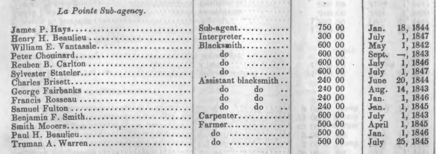
List of mid-late 1840s employees at the La Pointe Indian Sub-Agency including James P. Hayes and others.
~ Thirtieth Congress – First Session. Ex. Doc. No. 26. House of Representatives. Persons Employed In The Indian Department. Letter from The Secretary of War, Transmitting a statement of persons employed in the Indian Department. January 26, 1848.
June 22.
Jas. P. Hayes Esq. U. S. Sub Agt. recd his dismission & left in the Schooner Swallow– cause, Intemperance
July.
Fr. Boudrie arrived from Ontonagon with a cask of whiskied Cider– was prosecuted–a search warrant was issued & Peter Vandeventer was deputized to serve it. Van deventer After allowing abundant time for the service, Mr. Justice Bell & Van Tasell went to the building under search, & detected Van deventer in secreting a part of the cider. The whole was seized & destroyed by the owner–
Aug 28.
Propeller Independence arrived. Considerable intoxication among french & Half breeds.
“ 29
Schooner Napoleon, Clarke arrived with Govt provisions. Passengers Hyde, Wolcott & Martell
In discharging some bbls. of corn from the Propeller, on bbl. burst, & revealed a number of bottles of Liquor secreted among the Corn. The bbls were expressed back to the Sault. They have since been ascertained to belong have shipped by Martell of Sault St Maries. It was also reported by a passenger on the propeller, that the Napoleon was supposed to have on board a Bbl of Liquor belonging to Wolcott.
A number of Indians are reported to have had liquor about the time the Propeller left.
— An Indian was instigated by a Wht. man named Mills to murder two Americans living on Apple River–liquor was used in carry out Mills’s plans. The Ind was arrested & Hung, without judicial trial, at the Falls of St Croix.
— Majise shot killed in a drunken frolic on the St Croix. died next day–
— An old woman had her arm broken at the mouth of the Brule by a drunken son in law–Liquor furnished by Aug. Cadotte.
Sept 11.
Wood Smith & Vantassell Govt men, found 2 Kegs (about 12 [gal]) whiskey near the camp of Fr. Boudrie belonging to him, concealed in the ground–they immediately destroyed it.
6th
The sailboat Flying Indian arrived in the night of [Sunday] [day] last.
Sept 13.
Schooner Algonquin arrived from Sault St. Maries ~~~~~~~~~~~~~~~~~~~~~~~~~~~~~~~~~~~~~~~~~~~~~~~~~~~~~~~~~~~~~~~~~~~~~~~~~~~~~~~~~~~~~~~~~~~~~~~~~ Further information about the challenges of enforcing liquor laws at La Pointe can be found in the following:
“A real bona fide, unmitigated Irishman”
Reisen in Nordamerika: From Ontonagon to the mouth of the Bois-brule (Part 3)
1855 Inquest on the Body of Louis Gurnoe
1856 Inquest on the Body of Jerry Sullivan
~~~~~~~~~~~~~~~~~~~~~~~~~~~~~~~~~~~~~~~~~~~~~~~~~~~~~~~~~~~~~~~~~~~~~~~~~~~~~~~~~~~~~~~~~~~~~~~~~
Ely, Edmund Franklin, and Theresa M. Schenck. The Ojibwe Journals of Edmund F. Ely, 1833-1849. Lincoln: University of Nebraska, 2012. Print.
Folsom, William H. C., and E. E. Edwards. Fifty Years in the Northwest. St. Paul: Pioneer, 1888. Print.
Paap, Howard D. Red Cliff, Wisconsin: A History of an Ojibwe Community. St. Cloud, MN: North Star, 2013. Print.
Schenck, Theresa M. William W. Warren: The Life, Letters, and times of an Ojibwe Leader. Lincoln: University of Nebraska, 2007. Print.
Special thanks to Dr. Schenck for making this post possible.
By Leo
In April, the Supreme Court heard arguments in the case Department of Commerce v. New York and could render a decision any day on whether or not the 2020 federal census should include a question asking about citizenship status. In January, a Federal District Court in New York ruled that commerce secretary, Wilbur Ross, violated the law by pushing for that question.
Those in agreement with the District ruling suggest that the Trump administration wants to add the question as a way of discouraging immigrants from participating in the census, thereby diminishing the political power of immigrant communities. This, they say, would violate the Constitution on the grounds that the census must be an “actual enumeration” of all persons within the United States, not only citizens.
Proponents of the citizenship question counter that citizenship status is a perfectly natural question to ask in the census, that any government would want to know how many citizens it has, and that several past iterations of the 10-year count have included similar questions.
It remains to be seen how the Supreme Court will rule, but chances are it will not be the last time an issue of race, identity, or citizenship pops up in the politics of the census. From its creation by the Constitution as a way to apportion seats in congress according to populations of the states, the count has always begged tricky questions that essentially boil down to:
Who is a real American? Who isn’t? Who is a citizen? Who is three-fifths of a human being? Who might not be human at all? What does it mean to be White? To be Colored? To be civilized? How do you classify the myriad of human backgrounds, cultures and stories into finite, discrete “races?”
The Civil War and Fourteenth Amendment helped shed light on some of these questions, but it would be a mistake to think that they belong to the past. The NPR podcast Codeswitch has done an excellent series on census, and this episode from last August gives a broad overview of the history.
Here at Chequamegon History, though, we aren’t in the business broad overviews. We are going to drill down right into the data. We’ll comb through the 1850 federal census for La Pointe County and compare it with the 1860 data for La Pointe and Ashland Counties. Just for fun, we’ll compare both with the 1855 Wisconsin State Census for La Pointe County, then double back to the 1840 federal census for western St. Croix County. Ultimately, the hope is to help reveal how the population of the Chequamegon region viewed itself, and ultimately how that differed from mainstream America’s view. With luck, that will give us a framework for more stories like Amorin’s recent post on the killing of Louis Gurnoe.
Background
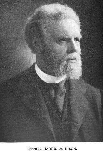 Judge Daniel Harris Johnson of Prairie du Chien had no apparent connection to Lake Superior when he was appointed to travel northward to conduct the census for La Pointe County in 1850. The event made an impression on him. It gets a mention in his short memorial biography in the 1902 Proceedings of the State Bar Association.
Two years after statehood, Lake Superior’s connection to the rest of Wisconsin was hardly existent. This was long before Highways 51 and 53 were built, and commerce still flowed west to east. Any communication to or from Madison was likely to first go through Michigan via Mackinaw and Sault Ste. Marie, or through Minnesota Territory via St. Paul, Stillwater, and Sandy Lake. La Pointe County had been created in 1845, and when official business had to happen, a motley assortment of local residents who could read and write English: Charles Oakes, John W. Bell, Antoine Gordon, Alexis Carpentier, Julius Austrian, Leonard Wheeler, etc. would meet to conduct the business.
It is unclear how much notice the majority Ojibwe and French-patois speaking population took of this or of the census generally. To them, the familiar institutions of American power, the Fur Company and the Indian Agency, were falling apart at La Pointe and reorganizing in St. Paul with dire consequences for the people of Chequamegon. When Johnson arrived in September, the Ojibwe people of Wisconsin had already been ordered to remove to Sandy Lake in Minnesota Territory for their promised annual payments for the sale of their land. That fall, the government would completely botch the payment, and by February, hundreds of people in the Lake Superior Bands would be dead from starvation and disease.
So, Daniel Johnson probably found a great deal of distraction and anxiety among the people he was charged to count. Indians, thought of by the United States as uncivilized federal wards and citizens of their own nations, were typically not enumerated. However, as I wrote about in my last post, race and identity were complicated at La Pointe, and the American citizens of the Chequamegon region also had plenty to lose from the removal.
Madison, for its part, largely ignored this remote, northern constituency and praised the efforts to remove the Ojibwe from the state. It isn’t clear how much Johnson was paying attention to these larger politics, however. He had his own concerns:

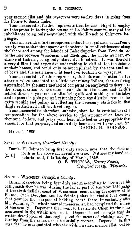
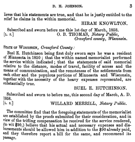
House Documents, Volume 119, Part 1. U.S. Government Printing Office, 1859. Google Books.
So, in “that thinly settled and half civilized region,” Johnson only found a population of about 500, “exclusive of Indians.” He didn’t think 500 was a lot, but by some counts, that number would have seemed very high. Take the word of a European visitor to La Pointe:
Among 200 Indians, only a few white families live there. One of the boatmen gave us a name, with which we found Mr. Austrian.
And, from this Mr. Austrian, himself:
There were only about 6 white American inhabitants on the Island, about 50 Canadian Frenchmen who were married to squaws, and a number of full blooded Indians, among whom was chief Buffalo who was a descendant of chiefs & who was a good Indian and favorably regarded by the people.
~Joseph Austrian, Brother of Julius and La Pointe resident 1851-52
Who lived around La Pointe in 1850?
In her biography, William W. Warren: the Life, Letters, and Times of an Ojibwe Leader, Theresa Schenck describes the short life of an ambitious young man from La Pointe. William Whipple Warren (1825-1853) grew up on the Island speaking Ojibwe as his first language. His father was a Yankee fur trader from New York. His mother was a daughter of Michel and Madeline Cadotte. In his famous History of the Ojibways Warren describes the Ojibwe as people with whom he readily claims kinship, but he doesn’t write as if he is an Ojibwe person himself. However, he helped interpret the Treaty of 1847 which had definitively made him an Indian in the eyes of the United States (a fact he was willing to use for economic gain). Still, a few years later, when he became a legislator in Minnesota Territory he dismissed challenges to his claims of whiteness.
If he were alive today, Warren might get a chuckle out of this line from the South African comedian Trevor Noah.
People mocked me. Gave me names like mixed breed, half caste — I hate that term ‘half’. Why half? Why not double? Or twice as nice, I don’t know.
— Trevor Noah
William Warren did not see himself as quite the walking contradiction we might see him as today. He was a product of the time and place he came from: La Pointe. By 1850, he had left that place, but his sister and a few hundred of his cousins still lived there. Many of them were counted in the census.
What is Metis?
Half-breeds, Mixed-bloods, Frenchmen, Wiisakodewininiwag, Mitif, Creoles, Metis, Canadiens, Bois Brules, Chicots, French-of-the-country, etc.–at times it seems each of these means the same thing. At other times each has a specific meaning. Each is ambiguous in its own way. In 1850, roughly half the families in the Chequamegon area fit into this hard-to-define category.

Kohl, J. G. Kitchi-Gami: Wanderings around Lake Superior. London: Chapman and Hall, 1860. pg. 260-61.
We were accompanied on our trip throughout the lakes of western Canada by half-Indians who had paternal European blood in their veins. Yet so often, a situation would allow us to spend a night inside rather than outdoors, but they always asked us to choose to Irish camp outside with the Indians, who lived at the various places. Although one spoke excellent English, and they were drawn more to the great American race, they thought, felt, and spoke—Indian! ~Carl Scherzer
In describing William Warren’s people, Dr. Schenck writes,
Although the most common term for people of mixed Indian and European ancestry in the nineteenth century was “half-breed,” the term “mixed blood” was also used. I have chosen to use the latter term, which is considered less offensive, although biologically inaccurate, today. The term “métis” was not in usage at the time, except to refer to a specific group of people of mixed ancestry in the British territories to the north. “Wissakodewinini,” the word used by the Ojibwe, meant “burned forest men,” or bois brulés in French, so called because half-breeds were like the wood of a burned forest, which is often burned on one side, and light on the other (pg. xv).
Schenck is correct in pointing out that mixed-blood was far more commonly used in 19th-century sources than Metis (though the latter term did exist). She is also correct in saying that the term is more associated with Canada and the Red River Country. There is an additional problem with Metis, in that 21st-century members of the Wannabe Tribe have latched onto the term and use it, incorrectly, to refer to anyone with partial Native ancestry but with no affiliation to a specific Indian community.
That said, I am going to use Metis for two reasons. The first is that although blood (i.e. genetic ancestry) seemed to be ubiquitous topic of conversation in these communities, I don’t think “blood” is what necessarily what defined them. The “pure-blooded French Voyageur” described above by Kohl clearly saw himself as part of Metis, rather than “blanc” society. There were also people of fully-Ojibwe ancestry who were associated more with Metis society than with traditional Ojibwe society (see my post from April). As such, I find Metis the more versatile and accurate term, given that it means “mixed,” which can be just as applicable to a culture and lifestyle as it is to a genetic lineage.

One time Canadian pariah turned national hero, Louis Riel and his followers had cousins at La Pointe (Photo: Wikipedia)
The second reason I prefer Metis is precisely because of the way it’s used in Manitoba. Analogous to the mestizo nations of Latin America, Metis is not a way of describing any person with Native and white ancestry. The Metis consider themselves a creole-indigenous nation unto themselves, with a unique culture and history. This history, already two centuries old by 1850, represents more than simply a borrowed blend of two other histories. Finally, the fur-trade families of Red River came from Sault Ste. Marie, Mackinac, Grand Portage, and La Pointe. There were plenty of Cadottes, Defaults, Roys, Gurnoes, and Gauthiers among them. There was even a Riel family at La Pointe. They were the same nation
Metis and Ojibwe Identity in the American Era
When the 1847 Treaty of Fond du Lac “stipulated that the half or mixed bloods of the Chippewas residing with them shall be considered Chippewa Indians, and shall, as such, be allowed to participate in all annuities which shall hereafter be paid…” in many ways, it contradicted two centuries of tradition. Metis identity, in part, was dependent on not being Indian. They were a minority culture within a larger traditional Anishinaabe society. This isn’t to say that Metis people were necessarily ashamed of their Native ancestors–expressions of pride are much easier to find than expressions shame–they were just a distinct people. This was supposedly based in religion and language, but I would argue it came mostly from paternal lineage (originating from highly-patriarchal French and Ojibwe societies) and with the nature of men’s work. For women, the distinction between Ojibwe and Metis was less stark.
The imposition of American hegemony over the Chequamegon region was gradual. With few exceptions, the Americans who came into the region from 1820 to 1850 were adult men. If new settlers wanted families, they followed the lead of American and British traders and married Metis and Ojibwe women.
Still, American society on the whole did not have a lot of room for the racial ambiguity present in Mexico or even Canada. A person was “white” or “colored.” Race mixing was seen as a problem that affected particular individuals. It was certainly not the basis for an entire nation. In this binary, if Metis people weren’t going to be Indian, they had to be white.
The story of the Metis and American citizenship is complicated and well-studied. There is risk of overgeneralizing, but let’s suffice to say that in relation to the United States government, Metis people did feel largely entitled to the privileges of citizenship (synonymous with whiteness until 1865), as well as to the privileges of Ojibwe citizenship. There wasn’t necessarily a contradiction.
Whatever qualms white America might have had if they’d known about it, Metis people voted in American elections, held offices, and were counted by the census.
Ojibwe “Full-bloods” and the United States Census
Representatives and direct Taxes shall be apportioned among the several States which
may be included within this Union, according to their respective Numbers, which shall be determined by adding to the whole Number of free Persons, including those bound to Service for a Term of Years, and excluding Indians not taxed, three fifths of all other Persons. The actual Enumeration shall be made within three Years after the first Meeting of the Congress of the United States, and within every subsequent Term of ten Years, in such Manner as they shall by Law direct.~Excerpt from Article I Section II, U. S. Constitution
As I argued in the April post, our modern conception of “full-blood” and “mixed-blood” has been shaped by the “scientific” racism of the late 19th and early 20th centuries. The distinction, while very real in a cultural sense, was not well-grounded in biology.
The relationship of Indians (i.e. full-bloods or those living a traditional lifestyle) to American society and citizenship was possibly more contradictory then that of the Metis. In one sense, America saw Indians as foreigners on their own continent: either as enemies to be exterminated, or as domestic-dependent ward nations to be “protected.” The constitutional language about the census calls for slaves to be counted as three-fifths of a person. It says Indians shouldn’t be counted at all.
In another sense, however, the path to personhood in America was somewhat clearer for Indians than it was for African Americans. Many New England liberals saw exodus to Liberia as the only viable future for free blacks. These same voices felt that Indians could be made white if only they were separated from their religions, cultures, and tribal identities. In 1834, to avoid a second removal, the Brothertown Indians of Wisconsin petitioned congress for citizenship and the termination of collective title to their tribal lands. In 1839, their request was granted. In the eyes of the law, they had effectively become white. Other communities would follow suit. However, most Native people did not gain any form of American citizenship until 1924.
How did that play out for the Ojibwe people of Chequamegon, and how did it impact the 1850 census? Well, it’s complicated.
Race, the Census, and Classifying Households
The enumeration forms Daniel H. Johnson carried to La Pointe had more rows and columns than ever. The Seventh Census was the first to count everyone in the household by name (previous versions only listed the Head of Household with tally marks). It was also the first census to have a box for “color.” Johnson’s choices for color were “white,” “black,” and “mulatto,” forcing him to make some decisions.
He seems to have tried to follow the Indians not taxed clause strictly. 40-50% of households in the region were headed by a full-blood Ojibwe person, possibly only two of them were enumerated. You won’t find Chief Buffalo, Makadebinesi (Blackbird), Oshkinaawe, Omizhinaawe, Edawegiizhig, and their immediate families in the 1850 census. Jechiikwii’o (often called Little Buffalo) is not in the document, even though he was an early Catholic convert, dressed in “white” clothing, and counted more Metis Ojibwe among his followers than full-bloods. However, his son, Antoine Buffalo Sr. (Antoine Jachequaon) is counted. Antoine, along with George Day, were counted as white heads of household by the census, though it is unclear if they had any European ancestry (Sources conflict. If anyone has genealogical information for the Buffalo and Day families, feel free to comment on the post). A handful of individuals called full-bloods in other sources, were listed as white. This includes 90-year old Madeline Cadotte, Marie Bosquet, and possibly the Wind sisters (presumably descendants of Noodin, one of the St. Croix chiefs who became Catholic and relocated to La Pointe around this time). They were married to Metis men or lived in Metis households. All Metis were listed as white.
Johnson did invent new category for five other Ojibwe people: “Civilized Indian,” which he seemed to use arbitrarily. Though also living in Metis households, Mary Ann Cadotte, Osquequa Baszina, Marcheoniquidoque, Charlotte Houle, and Charles Loonsfoot apparently couldn’t be marked white the way Madeline Cadotte was. These extra notations by Johnson and other enumeration marshals across the country are why the Seventh Federal Census is sometimes referred to as the first to count Native Americans.

So, out of 470 individuals enumerated at La Pointe and Bad River (I’ve excluded Fond du Lac from my study) Johnson listed 465 (99%) as white. By no definition, contemporary or modern, was the Chequamegon area 99% white in 1850. The vast majority of names on the lines had Ojibwe ancestry, and as Chippewas of Lake Superior, were receiving annuities from the treaties.
There were a few white American settlers. The Halls had been at La Pointe for twenty years. The Wheelers were well-established at Odanah. Junius and Jane Welton had arrived by then. George Nettleton was there, living with a fellow Ohioan James Cadwell. The infamous Indian agent, John Watrous, was there preparing the disastrous Sandy Lake removal. Less easy to describe as American settlers, but clearly of European origins, Fr. Otto Skolla was the Catholic priest, and Julius Austrian was the richest man it town.
There were also a handful of American bachelors who had drifted into the region and married Metis women. These first-wave settlers included government workers like William VanTassel, entrepreneurs like Peter VanderVenter, adventurers with an early connection to the region like Bob Boyd and John Bell, and homesteaders like Ervin Leihy.
It is unclear how many of French-surnamed heads of household were Chicots (of mixed ancestry) and how many were Canadiens (of fully-French ancestry). My sense is that it is about half and half. Some of this can be inferred from birthplace (though a birthplace of Canada could indicate across the river at Sault Ste. Marie as easily it could a farm in the St. Lawrence Valley). Intense genealogical study of each family might provide some clarifications, but I am going to follow Kohl’s voyageurs and not worry too much about it. Whether it was important or not to Jean Baptiste Denomie and Alexis Carpentier that they had no apparent Indian ancestry and that they had come from “the true homeland” of Quebec, for all intents and purposes they had spent their whole adult lives in “the Upper Country,” and their families were “of the Country.” They were Catholic and spoke a form of French that wasn’t taught in the universities. American society would not see them as white in the way it saw someone like Sherman Hall as white.
So, by my reckoning, 435 of the 470 people counted at La Pointe (92.5%) were Metis, full-blood Ojibwe living in Metis households, or Canadians in Metis families. Adding the five “Civilized Indians” and the six Americans married into Metis families, the number rises to 95%. I am trying to track down accurate data on the of Indians not taxed (i.e. non-enumerated full-bloods) living at or near La Pointe/Bad River at this time. My best estimates would put it roughly the same as the number of Metis. So, when Johnson describes a land with a language and culture foreign to English-speaking Americans, he’s right.
Birthplace, Age, and Gender
Ethnic composition is not the only data worth looking at if we want to know what this area was like 169 years ago. The numbers both challenge and confirm assumptions of how things worked.
Let’s take mobility for example:

The young voyageur quoted by Kohl may have felt like he didn’t have a home other than en voyage, but 86% of respondents reported being born in Wisconsin. Except for ten missionary children, all of these were Metis or “Civilized Indian.” Wisconsin could theoretically mean Lac du Flambeau, Rice Lake, or even Green Bay, this but this number still seemed high to me. I’m guessing more than 14% of 21st-century Chequamegon residents were born outside the state, and 19th-century records are all about commerce, long-distance travel, and new arrivals in new lands. We have to remember that most of those records are coming from that 14%.
In September of 1850 the federal government was telling the Ojibwe of Wisconsin they needed to leave Wisconsin forever. How the Metis fit into the story of the Sandy Lake Tragedy has always been somewhat fuzzy, but this data would indicate that for a clear majority, it meant a serious uprooting.
For those born outside Wisconsin, more than two-thirds reported being born in Michigan, Canada, or Minnesota Territory. These are overwhelmingly Metis or in the case of Anglo-Canadians like Robert Morrin, heads of Metis households from areas with a fur-trade tradition. Only eighteen individuals reported being born in the eastern United States. Only three reported Europe.
I had more questions than assumptions about the gender and age breakdown of the population. Would there be more women than men because of the dangerous jobs done by men or would mortality from childbirth balance that out? Or maybe widows wouldn’t be counted if they returned to the wigwams of their mothers? How would newcomers skew the age and gender demographics of the area?
Let’s take a look:
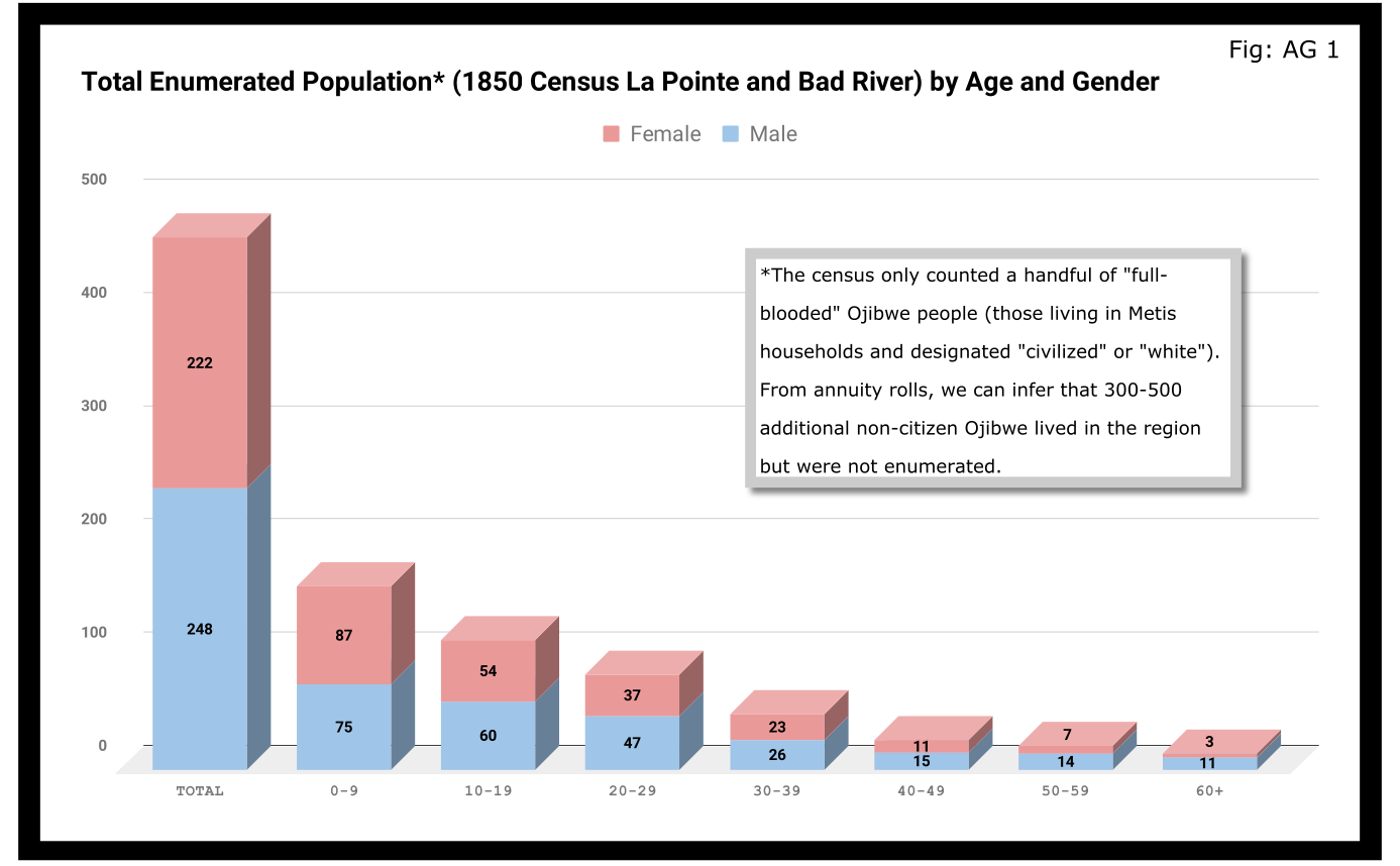
A quick glance at Figure AG 1 shows that the population skewed male 248-222 and skewed very young (61% under 20 years old). On the eve of Sandy Lake, the natural increase in the population seemed to be booming.

The hypotheses that women had higher mortality rates and were more likely to be undercounted looked good until we limit the data to the Wisconsin-born population. In Figure AG 2, we see that the male majority disappears entirely. The youthful trend, indicating large families and a growing population, continues with 66% of the Wisconsin-born population being under 20.

The male skew of the total population was entirely due to those born outside Wisconsin. This is not surprising given how much we’ve emphasized the number of men who came into the Lake Superior country to marry local women.
A look at the oldest residents in chart AG 2 and AG 3 hints at another story. Madeline Cadotte is the only Wisconsin-born person over seventy to be counted. The oldest men all came from Michigan and Canada. Why? My hypothesis is that between the fall of New France in 1759 and the establishment of Michel Cadotte’s post sometime around 1800, there wasn’t a large population or a very active fur trade around La Pointe proper. That meant Cadotte’s widow and other full bloods were the oldest locally-born residents in 1850. Their Metis contemporaries didn’t come over from the Soo or down from Grand Portage until 1810 or later.
Economics
Before the treaties, the economy of this area was built on two industries: foraging and trade. Life for Ojibwe people revolved around the seasonal harvest of fish, wild rice, game, maple sugar, light agriculture, and other forms of gathering food directly from the land. Trade did not start with the French, and even after the arrival of European goods into the region, the primary purpose of trade seemed to be for cementing alliances and for the acquisition of luxury goods and sacred objects. Richard White, Theresa Schenck, and Howard Paap have all challenged the myth of Ojibwe “dependence” on European goods for basic survival, and I find their arguments persuasive.
Trade, though, was the most important industry for Metis men and La Pointe was a center of this activity. The mid-19th century saw a steep decline in trade, however, to be replaced by a toxic cycle of debts, land sales, and annuity payments. The effects of this change on the Metis economy and society seem largely understudied. The fur trade though, was on its last legs. Again, the Austrian travel writer Carl Scherzer, who visited La Pointe in 1852:
After this discussion of the of the rates of the American Fur Company and its agents, we want to add some details about the men whose labor and time exerted such a great influence on the fate and culture of the Indian tribes. We wish to add a few explanatory words about the sad presence on La Pointe of the voyageurs or courriers du bois.
This peculiar class of people, which is like a vein of metal that suddenly disappears within the bedrock and reappears many hundreds of miles away under the same geological conditions, their light reaches the borders of the eastern Canadas. The British people, with their religion and customs, reappeared on the shores of these northern lakes only in 1808 with the Fur Company. For labor they drew on those who could carry their wares across the lakes and communicate with the Indians.
Many young men of adventurous natures left the old wide streets of Montreal and moved into the trackless primeval forests of the West. Young and strong as laborers, they soon started to adopt the lifestyle and language of the aborigines. They married with the Indians and inhabit small settlements scattered throughout those mighty lands which begin at Mackinow Island and come up the upper lake to the region of Minnesota. They almost all speak the Canadian patois along with the language of the Chippewas, the tribe with which they came into kinship. We found only a few, even among the younger generation, who understood English.
Since then, every day the population of the otherwise deserted shore of Lake Superior increases with the discovery of copper mines. The animals driven away by the whirlwind of civilization toward the west, attract the Indians with their sensitive guns, leaving La Pointe, abandoned by the Company for their headquarters at St. Paul in Minnesota. Most voyageurs left the island, having seen their business in ruins and lacking their former importance. Just a few families remain here, making a meager livelihood of hunting, fishing, and the occasional convoy of a few travelers led by business, science, or love of nature who purchase their limited resources.
From Scherzer’s description, two things are clear. It’s pretty clear from the flowery language of the Viennese visitor.Washington Irving and other Romantic-Era authors had already made the Voyageur into the stock stereotypical character we all know today. Th only change, though, is these days voyageurs are often depicted as representatives of white culture, but that’s a post for another time.
The second item, more pertinent to this post, is that a lot of voyageurs were out of work. This is especially relevant when we look at our census data. Daniel Johnson recorded the occupations of all males fifteen or over:
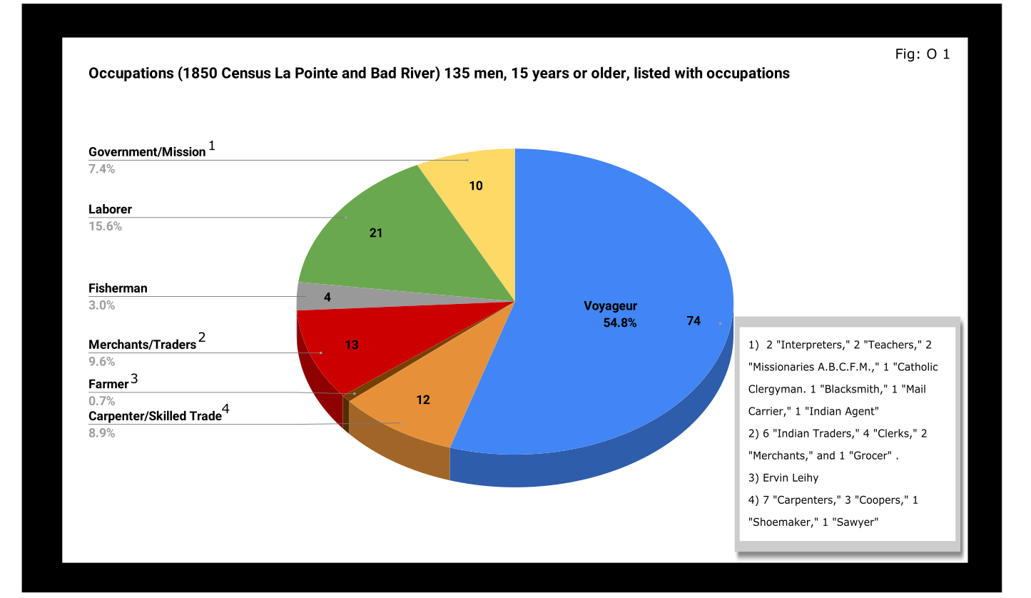
A full 55% of enumerated men fifteen and older still identified themselves as voyageurs in 1850. This included teenagers as well as senior citizens. All were from Metis households, though aside from farmer, all of the other occupation categories in Figure O 1 included Metis people.

A look at household sizes did not show voyageurs having to support significantly larger or smaller families when compared to the other occupation categories.
The other piece of economic data collected was value of real estate. Here we see some interesting themes:

If real estate is a good proxy for wealth in a farming community, it is an imperfect one in the Chequamegon area of 1850. If a voyageur had no home but the river and portage, then we might not expect him to put his coin into land and buildings. A teacher or Indian agent might draw a consistent salary but then live in supplied housing before moving on. With that caveat, let’s dig into the data.
Excluding the single farmer, men in the merchant/trader group controlled the most wealth in real estate, with Julius Austrian controlling as much as the other merchants combined. Behind them were carpenters and men with specific trades like cooper or shoemaker. Those who reported their occupation generally as “laborer” were not far behind the tradesmen. I suspect their real estate holdings may be larger and less varied than expected because of the number of sons and close relatives of Michel Cadotte Sr. who identified themselves as laborers. Government and mission employees held relatively little real estate, but the institutions they represented certainly weren’t lacking in land or power. Voyageurs come in seventh, just behind widows and ahead of fishermen of which there were only four in each category.
It is interesting, though, that the second and third richest men (by real estate) were both voyageurs, and voyageur shows a much wider range of households than some of the other categories: laborers in particular. With the number of teenagers calling themselves voyageurs, I suspect that the job still had more social prestige attached to it, in 1850, than say farmer or carpenter.
With hindsight we know that after 1854, voyageurs would be encouraged to take up farming and commercial fishing. It is striking, however, how small these industries were in 1850. Despite the American Fur Company’s efforts to push its Metis employees into commercial fishing in the 1830s, and knowing how many of the family names in Figure O 3 are associated with the industry, commercial fishing seemed neither popular nor lucrative in 1850. I do suspect, however, that the line between commercial and subsistence fishing was less defined in those days and that fishing in general was seen as falling back on the Indian gathering lifestyle. It wouldn’t be surprised if all these families were fishing alongside their Ojibwe relatives but didn’t really see fishing (or sugaring, etc.) as an occupation in the American sense.
Finally, it could not have escaped the voyageurs notice that while they were struggling, their former employers and their employers educated sons were doing pretty well. They also would have noticed that it was less and less from furs. Lump annuity payments for Ojibwe land sales brought large amounts of cash into the economy one day a year. It must have felt like piranhas with blood in the water. Alongside their full-blood cousins, Metis Ojibwe received these payments after 1847, but they had more of a history with money and capitalism. Whether to identify with the piranha or the prey would have depended on all sorts of decisions, opportunities and circumstances.
Education and Literacy
The census also collected data on education and literacy, asking whether children had attended school within the year, and whether adults over twenty could read and write. The history of white education efforts in this area are fairly well documented. The local schools in 1850 were run by the American Board of Commissioners of Foreign Missions (A.B.C.F.M.) at the La Pointe and Odanah missions, and an entire generation had come of age at La Pointe in the years since Rev. Sherman Hall first taught out of Lyman Warren’s storehouse in 1831. These Protestant ministers and teachers railed against the papists and heathens in their writings, but most of their students were Catholic or traditional Ojibwe in religion. Interestingly, much of the instruction was done in the Ojibwe language. Unfortunately, however, the census does not indicate the language an individual is literate in. I highly recommend The Ojibwe Journals of Edmund F. Ely, 1833-1849 if you are interested in these topics.
To start with, though, let’s look at how many people were going to school:

Thirty-nine students had gone to school in the previous year. There is a lot of sample-size noise in the data, but it seems like ages 7-11 (what we would call the upper-elementary years) were the prime years to attend school.
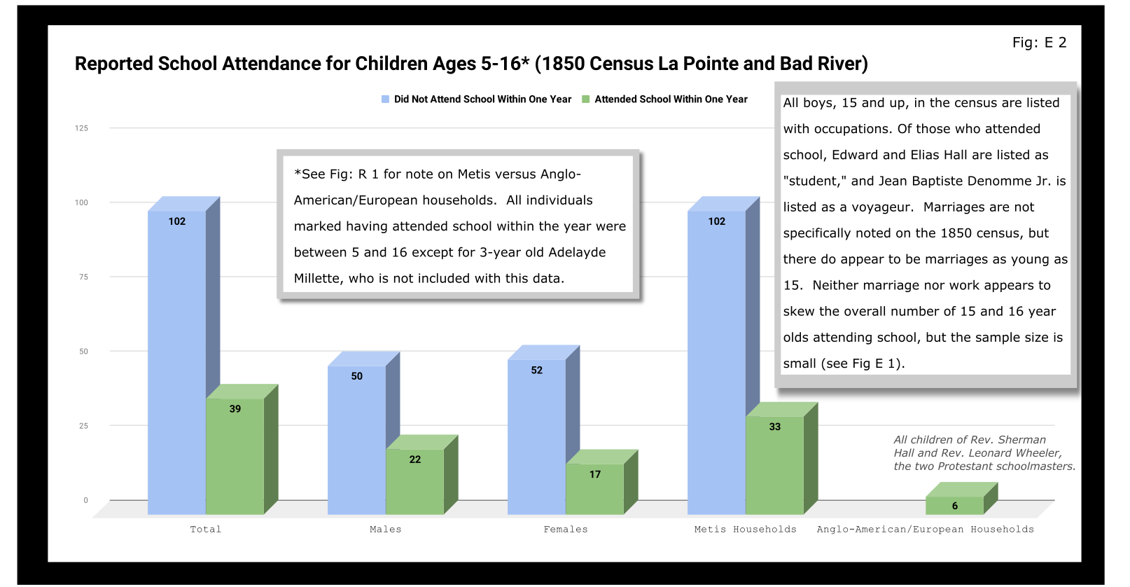
Overall, most children had not attended school within the year. Attendance rates were slightly higher for boys than for girls. White children, all from two missionary families, had a 100% attendance rate compared to 24% for the Metis and “Civilized Indian” children.
We should remember, however, that not attending school within the year is not the same as having never attended school. Twelve-year-old Eliza Morrin (later Morrison) is among the number that didn’t attend school, but she was educated enough to write her memoirs in English, which was her second language. They were published in 2002 as A Little History of My Forest Life, a fascinating account of Metis life in the decades following 1854.
Eliza’s parents were among the La Pointe adults who could read and write. Her aunt, uncle, and adult cousins in the neighboring Bosquet (Buskey) house were not. Overall, just over half of adults over 20 were illiterate without a significant gender imbalance. Splitting by birthplace, however, shows the literacy rate for Wisconsin-born (i.e. Metis and “Civilized Indian”) was only 30%, down from the overall male literacy rate of 48%. For Wisconsin-born women, the drop is only three points, from 47% to 44%. This suggests Metis women were learning to read while their husbands and brothers (perhaps en voyage) were not.

And this is exactly what the data say when we split by occupation. The literacy rate for voyageurs was only 13%. This beats fisherman–all four were illiterate–but lagged far behind all other types of work.
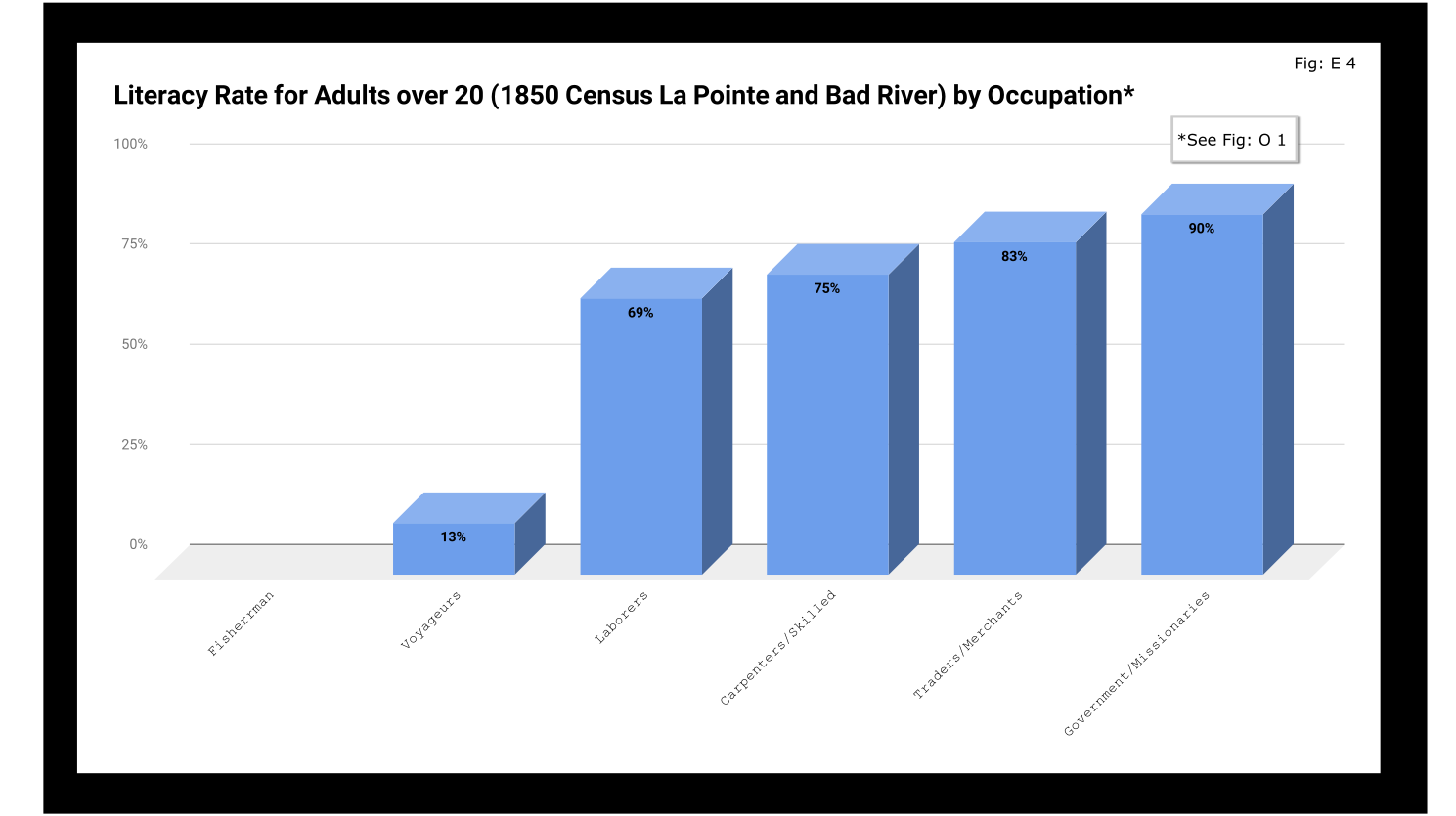
If education was going to be a factor in the economic mobility of unemployed voyageurs, the trends weren’t looking good.
Odds and Ends
Two marriages were reported as occurring in the year previous to the census: Peter and Caroline Vanderventer and Pierre and Marguerite Robideaux (ak.a. Peter and Margaret Rabideaux). Though married, however, Caroline was not living with her husband, a 32-year old grocer from New York. She (along with their infant daughter) was still in the home of her parents Benjamin and Margaret Moreau (Morrow). The Vanderventers eventually built a home together and went on to have several more children. It appears their grandson George Vanderventer married Julia Rabideaux, the granddaughter of Peter and Margaret.
I say appears in the case of George and Julia, because Metis genealogy can be tricky. It requires lots of double and triple checking. Here’s what I came across when I once tried to find an unidentified voyageur known only as Baptiste:

Sometimes it feels like for every Souverain Denis or Argapit Archambeau, there are at least 15 Jean-Baptiste Cadottes, 12 Charles Bresettes, 10 Francois Belangers and 8 Joseph DeFoes. Those old Canadian names had a way of persisting through the generations. If you were a voyageur at La Pointe in 1850, there was nearly a 30% chance your name was Jean-Baptiste. To your friends you might be John-Baptist, Shabadis, John, JB, or Battisens, and you might be called something else entirely when the census taker came around.
The final column on Daniel Johnson’s census asked whether the enumerated person was “deaf and dumb, blind, insane, idiotic, pauper, or convict.” 20 year-old Isabella Tremble, living in the household of Charles Oakes, received the unfortunate designation of idiotic. 26-year-old Francois DeCouteau did not have a mark in that column, but had “Invalid” entered in for his occupation. It’s fair to say we’ve made some progress in the treatment of people with disabilities.
Final Thoughts
I am not usually a numbers person when it comes to history. I’ll always prefer a good narrative story, to charts, tables, and cold numbers. Sometimes, though, the numbers help tell the story. They can help us understand why when Louis Gurnoe was killed, no one was held accountable. At the very least, they can help show us that the society he lived in was under significant stress, that the once-prestigious occupation of his forefathers would no longer sustain a family, and that the new American power structure didn’t really understand or care who his people were.
Ultimately, the census is about America describes itself. From the very beginning, it’s never been entirely clear if in E. pluribus unum we should emphasize the pluribus or the unum. We struggled with that in 1850, and we still struggle today. To follow the Department of Commerce v. New York citizenship case, I recommend Scotusblog. For more census posts about this area in the 19th century, keep following Chequamegon History.
Sources, Data, and Further Reading
-
Paap, Howard D. Red Cliff, Wisconsin a History of an Ojibwe Community ; Volume 1 The Earliest Years: the Origin to 1854. North Star Press of St. Cloud, Inc., 1854.
-
Satz, Ronald N. Chippewa Treaty Rights: the Reserved Rights of Wisconsin’s Chippewa Indians in Historical Perspective. University of Wisconsin Press, 1997.
-
Original Census Act of May 23, 1850 (includes form and instructions for marshals). (PDF)
-
Compiled data spreadsheets (Google Drive Folder) I’ll make these a lot more user friendly in future census posts. By the time it occurred to me that I should include my tables in this post, most of them were already done in tally marks on scrap paper.
-
Finally, these are the original pages, scanned from microfilm by FamilySearch.com. I included the image for Fond du Lac (presumably those living on the Wisconsin side of the St. Louis River) even though I did not include it in any of the data above.
-

- Bad River
-
- Fond du Lac (not included in above data)


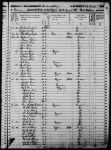
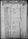


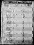
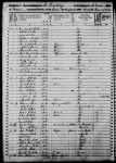
Among The Otchipwees: I
May 28, 2016
By Amorin Mello

Magazine of Western History Illustrated
No. 2 December 1884
as republished in
Magazine of Western History: Volume I, pages 86-91.
AMONG THE OTCHIPWEES.
Like all the northern tribes, the Chippewas are known by a variety of names. The early French called them Sauteus, meaning people of the Sault. Later missionaries and historians speak of them as Ojibways, or Odjibwes. By a corruption of this comes the Chippewa of the English.

“No-tin” copied from 1824 Charles Bird King original by Henry Inman in 1832-33. Noodin (Wind) was a prominent Chippewa chief from the St. Croix country.
~ Commons.Wikimedia.org
On the south of the Chippewas, in 1832, across the Straits of Mackinaw, were the Ottawas. Some of this nation were found by Champlain on the Ottawa River of Canada, whom he called Ottawawas. In later years there were some of them on Lake Superior, of whom it is probable the Lake Court Oreille band, in northwestern Wisconsin, is a remainder. The French call them “Court Oreillés,”, or short ears. All combined, it is not a powerful nation. Many of them pluck the hair from a large part of the scalp, leaving only a scalp lock. This custom they explain as a concession to their enemies, in order to make a more neat and rapid job of the scalping process. A thick head of coarse hair, they say, is a great impediment. Probably the true reason is a notion of theirs that a scalp lock is ornamental. The practice is not universal among Ottawas, and is not common with the neighboring tribes. These were the people who committed the massacre of the English garrison at Old Mackinaw, in 1763.
![Mah-kée-mee-teuv, Grizzly Bear, Chief of the [Menominee] Tribe by George Catlin, 1831. ~ Smithsonian Institute](https://chequamegonhistory.com/wp-content/uploads/2016/05/1831-mah-kee-mee-teuv-grizzly-bear-by-george-catlin.jpg)
“Mah-kée-mee-teuv, Grizzly Bear, Chief of the [Menominee] Tribe” by George Catlin, 1831.
~ Smithsonian Institute
The Oneidas, a small remnant of that nation, from New York, were located on Duck River, near Fort Howard, and the Tuscaroras on the south shore of Lake Winnebago.

Detail from “Among The Winnebago [Ho-Chunk] Indians. Wah-con-ja-z-gah (Yellow Thunder) Warrior chief 120 y’s old” stereograph by Henry Hamilton Bennett, circa 1870s.
~ J. Paul Getty Museum
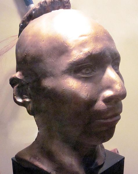
Plaster life cast of Sac leader Black Hawk (Makatai Meshe Kiakiak) reproduced by Bill Whittaker (original was made circa 1830) on display at Black Hawk State Historic Site.
~ Wikipedia.org
Next to the Menominees on the west were the Winnebagoes, a barbarous, warlike and treacherous people, even for Indians. Their northern border joined the Chippewas. Yellow Thunder’s village, in 1832, was on the trail from Lake Winnebago to Fort Winnebago, south of the Fox River about half way. He was more of a prophet, medicine man or priest, than warrior. In the Black Hawk war man of the Winnebago bucks joined the Sacs and the Foxes. Only four years before the United States was obliged to send an expedition against them, and to build a stockade at the portage. Their chiefs, old men, and medicine men, professed to be very friendly to us, but kept up constant communications with Black Hawk. When he was beaten at the Bad Ax River, and his warriors dispersed, they followed the old chief into the northern forest, captured him, and delivered him to the United States forces.
One of the causes of the Black Hawk War in 1832 was the murder of a party of Menominees near Fort Crawford, by the Sacs and Foxes. There was an ancient feud between those tribes which implies a series of scalping parties from generation to generation.

Sac leader “Ke-o-kuk or the Watchful Fox” by Thomas M. Easterly, 1847.
~ Missouri History Museum
As the Menominees were at peace with the United States, and their camps were near the garrison, they were considered to have been under Federal protection, and their murder as an insult to its authority. The return of Keokuk’s band to the Rock River country brought on a crisis in the month of May. The Menominees were anxious to avenge themselves, but were quieted by the promise of the government that the Sacs and Foxes should be punished. They offered to accompany our troops as scouts or spies, which was not accepted until the month of July, when Black Hawk had returned to the Four Lakes, where is now the city of Madison.
On a bright afternoon, about the middle of the month, a company of Menominee warriors emerged in single file from the woods in rear of Fort Howard at the head of Green Bay. They numbered about seventy-five, each one with a gun in his right hand, a blanket over his right shoulder, held across the breast by the naked left arm, and a tomahawk. Around the waist was a belt, on which was a pouch and a sheath, with a scalping knife. Their step was high and elastic, according to the custom of the men of the woods. On their faces was an excess of black paint, made more hideous by streaks of red. Their coarse black hair was decorated with all the ribbons and feathers at their command. Some wore moccasins and leggings of deer skin, but a majority were barefooted and barelegged. They passed across the common to the ferry, where they were crossed to Navarino, and marched to the Indian Agency at Shantytown. Here they made booths of the branches of trees. Captain or Colonel Hamilton, a son of Alexander Hamilton, was their commander. As they had an abundance to eat and were filled with martial prowess, they were exceedingly jubilant.
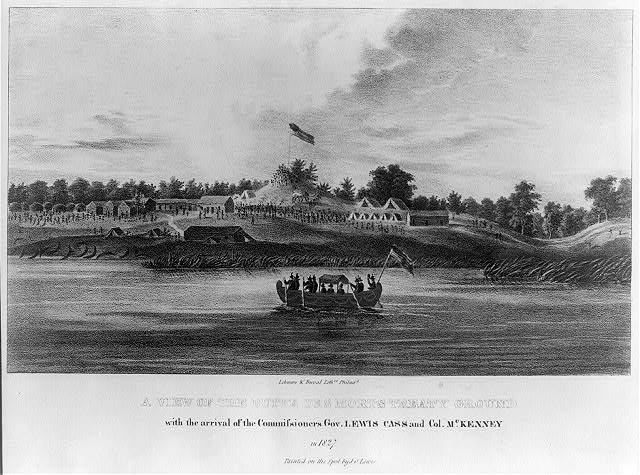
“A view of the Butte des Morts treaty ground with the arrival of the commissioners Gov. Lewis Cass and Col. McKenney in 1827” by James Otto Lewis, 1835.
~ Library of Congress
Their march was up the valley of the river, recrossing above Des Peres, passing the great Kakolin, and the Big Butte des Morts to the present site of Oshkosh. Thence crossing again they followed the trail to the Winnebago villages, past the Apukwa or Rice lakes to Fort Winnebago, making about twenty miles a day. On the route they were inclined to straggle, presenting nothing of military aspect except a uniform of dirty blankets. Colonel Hamilton was not able to make them stand guard, or to send out regular pickets. They were expert scouts in the day time, but at night lay down to sleep in security, trusting to their dogs, their keen sense of hearing and the great spirit. On the approach of day they were on the alert. It is a rule in Indian tactics to operate by surprises, and to attack at the first show of light in the morning.
From Fort Winnebago they moved to the Four Lakes, where Madison now is. Black Hawk had retired across the Wisconsin River, where there was a skirmish on the 21st of July, and the battle of the Bad Ax was being fought.

Photograph of Pierre Jean Édouard Desor (Swiss geologist and professor at Neuchâtel academy) from Wisconsin Historical Society. Desor and others were employed to survey for Report on the geology and topography of a portion of the Lake Superior Land District in the state of Michigan: Part I, Copper Lands; Part II, The Iron Region.
A few miles southwesterly of Waukedah, on the branch railroad to the iron mines of the upper Menominee, is a lake called by the Indians “Shope,” or Shoulder Lake, which I visited in the fall of 1850, in company with the late Edward Desor, a scientist of reputation in Switzerland. It discharges into the Sturgeon River, one of the eastern branches of the Menominee. There was a collection of half a dozen lodges, or wigwams, covered with bark, with a small field of corn, and the usual filth of an Indian village. The patriarch, or “chief” of that clan, came out to meet us, attended by about thirty men, women and children. By the traders he was called “Governor.” His nose was prominently Roman. He stood evenly on both feet, with his limbs bare below the knees. The right arm was also bare, and over the left shoulder was thrown a dirty blanket, covering the chest and the hips. A mass of coarse black hair covered the head, but was pushed away from the face. The usual dark, steady, snakelike, black eye of the race examined us with a piercing gaze. His face, with its large, well proportioned features, was almost grand. his pose was easy, unstudied and dignified, like one’s ideal of the Roman patrician of the time of Cicero, such as sculptors would select as a model.
This band were the Chippewas, but the coast of Green Bay was occupied by Menominees or Menomins, known to the French as “Folle Avoines,” or “Wild Rice” Indians, for which Menomin is the native name. Above the Twin Falls of the Menominee was an ancient village of Chippewas, called the “Bad Water” band, which is their name for a series of charming lakes not far distant, on the west of the river. They said their squaws, a long time since, were on the lakes in a bark canoe. Those on the land saw the canoe stand up on end, and disappear beneath the surface with all who were in it. “Very bad water.” From that time they were called the “Bad Water” lakes.

The Bad Water Band of Lake Superior Chippewa was first documented by Captain Thomas Jefferson Cram in his 1840 report to Congress.
~ Dickinson County Library
Cavalier was a half-breed French and Menominee. He was a handsome young man, and was well aware of it. Though he was married, the squaws received his attentions without much reserve. Half-breeds dress like the whites of the trading post, and not as Indians. Their hair is cut, and instead of a blanket they have coarse overcoats, and wear hats. Many of them are traders, a class mid-way between the whites and Indians.

No Princess Zone: Hanging Cloud, the Ogichidaakwe is a popular feature here on Chequamegon History.
Polygamy is the most fixed of savage institutions, and one that the half-breed and trader does not despise. Chippewa maidens, and even wives, have many reasons for looking kindly upon men who wear citizens’ clothes and trade in finery. Moccasins they can make very beautifully, but shawls and strouds of broadcloth, silk ribbons, pewter broaches, brass rings, and glass beads they cannot. These are the work of the white man. But none of that race, man or maid, has a more powerful passion for the ornamental than the children of the forest, male or female. Let us not judge the latter too harshly – poor, ignorant, suffering slave, with none of the protection which the African slave could sometimes invoke against barbarian cruelty. Their children are as happy and playful as those of the white race. Before they become men and women they are frequently beautiful, the deep brunette of their complexion having, on the cheek, a faint tinge of a lighter color, especially among those from the far north, like the “Bois Forts” of Rainy Lake. Young lads and girls have well formed limbs and straight figures, with agile and graceful movements. At this age the burdens and hardships of the squaws have not deformed them. The smoke of the lodge has not tanned their skin to Arab-like blackness nor inflamed their eyes. In about ten years of drudgery, rowing the canoe, putting up lodges, bearing children, and not infrequent beatings by her lord, the squaw is an old woman. Her features become rough and angular, the melodious voice of childhood is changed to one that is sharp, shrill, piercing and disagreeable. At forty she is a decrepit old woman, and before that time, if her master has not put her away, he may have installed number two as an additional tyrant.
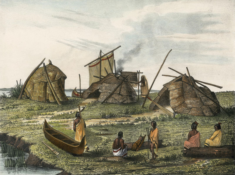
A Menominee village in “Village of Folle-Avoines” by Francis de Laporte de Castelnau, 1842.
~ Wisconsin Historical Society
Well up the Peshtigo, on a rainy, foggy afternoon, we made an early camp near a dismal swamp on the low ground. On the other side of the river, at a considerable distance, was heard the moans of a person evidently in great distress. Cavalier was sent over to investigate. He found a wigwam with a Menominee and two women, both wives. The youngest was on a bridal tour. The old wife had broken her thigh about a month before, which had not been set. She was suffering intensely, the limb very much swollen, and the bridal party wholly neglecting her. It was evident that death was her only relief. A strong dose of morphine gradually moderated her groans, which were more pathetic than anything that ever reached my ears. Before morning she was quiet.
As the water was very low I went through the gorge of the Menominee above the Great Bekuennesec, or Smoky Falls. Near the lower end, and in hearing of the cataract, I saw through the rocky chasm a mountain in the distance to the northeast. My half-breed said the Indians called it Thunder Mountain. They say that thunder is caused by an immense bird which goes there, when it is enveloped by clouds and flaps its wings furiously.
Turning away from the mists of the cataract and its never ceasing roar, we went southwesterly among the pines, over rocks and through swamps, to a time worm trail leading from the Bad Water village to the Pemenee Falls. This had been for many years the land route from Kewenaw Bay to the waters of Green Bay at the mouth of the Menominee River. When the copper mines on Point Kewenaw were opened, in 1844 and 1845, the winter mail was carried over this route on dog trains, or on the backs of men. Deer were very plenty in the Menominee valley. Bands of Pottawatomies scoured the woods, killing them by hundreds for their skins. We did not kill them until near the close of the day, when about to encamp. Cavalier went forward along the trail to make camp and shoot a deer. I heard the report of his gun, and expected the usual feast of fresh venison. “Where is your deer?” “Don’t know; some one has put a spell on my gun, and I believe I know who did it.”
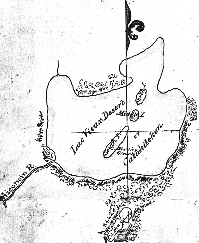
Map of Lac Vieux Desert with “Catakitekon” [Gete-gitigaan (old gardens)] from Thomas Jefferson Cram’s 1840 fieldbook.
~ School District of Marshfield: Digital Time Travelers
The Chippewas are spread over the shores and the rivers of Lake Superior, Lake Nipigon, the heads of the Mississippi, the waters of Red Lake, Rainy Lake and the tributaries of the Lake of the Woods. When Du Lhut and Hennepin first became acquainted with the tribes in that region, the Sioux, Dacotas, or Nadowessioux, and the Chippewas were at war, as they have been ever since. The Sioux of the woods were located on the Rum, or Spirit River, and their warriors had defeated the Chippewas at the west end of Lake Superior. Hennepin was a prisoner with a band of Sioux on Mille Lac, in 1680, at the head of Rum River, called Isatis. When Johnathan Carver was on the upper Mississippi, in 1769, the Chippewas had nearly cleared the country between there and Lake Superior of their enemies. In 1848 their war parties were still making raids on the Sioux and the Sioux upon them.
CHARLES WHITTLESEY.
To be continued in Among The Otchipwees: II…
Wisconsin Territory Delegation: Saint Croix Falls
April 28, 2016
By Amorin Mello
A curious series of correspondences from “Morgan”
… continued from La Pointe.

The Daily Union (Washington D.C.)
“Liberty, The Union, And The Constitution.”
August 27, 1845.
EDITOR’S CORRESPONDENCE.
—
(From our regular correspondent.)
FALLS, ST. CROIX, W. T., Aug. 7, 1845.
We left La Pointe on the afternoon of the day on which my last letter was dated. We had about 70 miles (English,) or 63 of French voyageur’s miles, to travel westward on the lake, before reaching the Brulé river, which we were to ascend for 75 miles, to make the portage to the St. Croix; the latter river being, from its source to the Mississippi river, including the Lake St. Croix at its mouth, about 300 miles long – thus making a journey before us of about 445 miles to reach the Mississippi. To La Pointe we had already coasted from Sault St. Marie, including the curves, bends, bays, &c , with the entire circuit of Keweena point, the distance of at least 500 miles. The two added together, give 945 miles of travel, in open boats by day, and under tents by night, with the exception of the three miles portage between the two rivers. We left the Sault on the 4th July, and reached this place within 50 miles of the Mississippi, making the whole time consumed one month and about three or four days, by the time we will have reached the “father of waters.”

Detail of the shoreline between La Pointe and the Bois Brulé River from Map of the Mineral Lands Upon Lake Superior Ceded to the United States by the Treaty of 1842 With the Chippeway Indians.
~ Wisconsin Historical Society
The distance, in a direct line, from the head of the bay opposite La Pointe, to the portage at the head of the Brulé, by land, is only 80 miles; while by the lake and river, it is about 145. The whole distance, in a direct line, by land, from La Pointe to the falls of St. Anthony, or to the mouth of the St. Peter’s, does not exceed, by the Indian trail alluded to, over 200 miles.
The first day we left La Pointe we were only enabled to reach Raspberry river, a small stream emptying into the lake 15 miles west of La Pointe, inside the group of islands.
We first encountered a prodigious thick fog, with a head wind. We had no sooner landed and raised our tent, than a thunder-storm, with a heavy rain, burst upon us. The voyageurs, as is their custom, had puled the bark canoes out of the water, and turned them over, placing provisions and other articles under them for shelter. The Indians, in travelling with their canoes, invariably pull them out of the water at night, turn them bottom upwards, and in bad weather, sleep under them; as our voyageurs (especially Jocko, our Indian voyageur) did on the night in question. In such cases, they turn water like the roof of a house. We had, late in the afternoon, doubled some frowning sandstone cliffs alluded to in my other letter, with the grottoes, caves, and excavations wrought out near the water’s edge, by the combined action of the waves and frost. Another high sandstone promontory still lay just ahead of us, which Ribedoux, our head man, said extended for six miles without affording a landing-place for a boat.
Next morning we found a severe gale blowing from the north-northeast, accompanied with rain. This compelled us to remain where we were till about 3 or 4 o’clock in the afternoon, when we set out. The wind had died away, but the sea was running very high, over which our canoes danced along at a great rate – riding them, however, like swans. The heaviest rolls would be mounted and slid over with as much ease as though the canoes were feathers, as they were propelled forward by the oars and paddles of our skillful voyageurs.
One canoe being small, only admitted of the use of paddles. The larger craft allowed a pair of oars to be used in front, while a paddle was employed in the stern. The usual plan of working canoes is to have only two persons to attend to one canoe. They are always steered with a paddle. One voyageur seats himself in the bow; while another does the same thing in the stern – the baggage, provisions, passengers, &c., being stored amidships, low in the hull. Thus arranged, the men apply their paddles with great skill, driving the canoe forward at a pretty rapid speed.
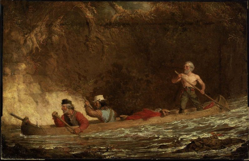
The Voyageurs by Charles Deas, 1846.
~ Commons.Wikimedia.org
The Indians display a deal of skill in the construction of their bark canoes. Their hulls have great symmetry of form; and, under careful handling, which the Indians perfectly understand and practise, they are very light and very strong.
The birch bark, from which they are principally made, is found of excellent quality on the shores and tributaries of Lake Superior, and is extensively used by the Indians for building their lodges, &c., as well as for canoes. In the latter application, the inside of the bark is exposed to the water and weather; while, in the former case, the outside of the bark is turned to the weather. Their lodges are of a hemispherical shape, with an opening at the top for the escape of smoke, with a door opening on one side of them, before which a blanket is usually suspended. The floor of the lodge, with the wealthier class, is usually covered with fine large richly-colored rush mats, on which the Indians recline or sit like Turks on them. The men, when at home, do little else than recline on the mats and smoke, while the squaws and half-grown children perform all the necessary manual labor. If an Indian brings in game or fish, he throws it down near his lodge, and troubles himself no more about it; or, if it be troublesome to carry, he leaves it in the woods, returns to the lodge, and sends his squaw for it.
The females among the Indians invariable exhibit the most modest and retiring deportment – equally as much so, I have thought, as is seen or met with among the most civilized whites. Neither males nor females, when you enter their villages or lodges, ever fix upon you that rude glare, or gaze, which white people often do upon the sudden appearance of a stranger. The usual salutation of the Chippewa, on meeting you, is “Bojour, bojour, bojour,” at the same time extending his hand to you in friendship. And if there are fifty men in company, they will all do the same thing. The exclamations they use is a corruption of the French salutation of “bon jour,” “good day;” or, in English parlance, “how d’ye do.”
The Indians are very fond of bathing and swimming, and they do not consider it the least indelicate for all sexes to bathe at the same time in the immediate vicinity of each other. I am told, on such occasions, the females wear dresses prepared for the purpose. The men also are partly clad.
“There are indications that Granville served as a teacher in a school unrelated to ABCFM on or near the Mackinaw Island from the fall of 1834 to the fall of 1835. His first connection with ABCFM dates from September 1835, and he was officially appointed by ABCFM as a missionary assistant some time in 1836. Granville took a leave between July 1837 and June 1838, then returned to La Pointe with his newly wed wife, Florantha nee Thompson. After one unsuccessful pregnancy, Florantha had two healthy daughters, in October 1842, and March 1844. Granville and Florantha retired from the mission in the summer of 1846.”
~ The Sproats at La Pointe: From pages of the Missionary Herald, Boston
I was told by Mr. Grote, who has resided at the Presbyterian mission at La Pointe for some 10 or 12 years, that the Indians, during long peace, and when little surrounds them of a nature to arouse or excite their energies, become, in general, very lethargic, and sink apparently (from ennui) into premature old age, few of them attaining to the years of advanced life. Among the chiefs I saw at La Pointe, was an old man of sixty. His hair was quite gray. He was introduced to me by a friend, at his own request. He wanted to know where I was from, and whether I had been sent to carry off the Indians. He was told that I had come on no such errand, but merely to visit and see the country, and that I was a “medicine man,” a “mushkiwinini:” this announcement put me on a very friendly footing with him. He bore a strong resemblance to Robert Dale Owen, the lecturer.
I was told by Mr. Grote that this old chief retained very strong predilections in favor of the British; that he frequently spoke of the good old times when they received fine presents and cheap goods from their great father, the King over the water; and that he annually paid a visit to the Hudson Bay Company’s trading-post at Fort William, or at the Sault, and received presents to some small amount. he nevertheless professed much friendship for the Americans.

“Mainland sea caves from the water.”
~ Apostle Islands National Lakeshore
We left Raspberry river between 3 and 4 p.m., and passed one among the most picturesque cliffs of sand-stone it was our lot to see during the voyage. It spread along the shore for 6 or 7 miles, varying in height from 50 to 100 feet. Its base was carved into holes and grottoes of every variety of form, into which the heavy rolls of the waves were pitching with a rumbling and heavy sound; while the white spray flew in foaming whiteness about the outward rocks. Making a beach near dark at the bottom of the bay, beyond the cliffs, we landed and camped. Early next morning we were again under way. In the afternoon we passed four Indian canoes loaded with Indians bound for La Pointe. They were from Fond-du-Lac.
Making Cranberry river, we found Capt. Stanard and his party of voyageurs, who had preceded us from La Pointe, and were bound for Fond-du-Lac, had stopped for dinner. We concluded to land at the same place for the same purpose.
We were told by Capt. S that he had, on his way, visited an encampment of Indians from Fond-du-Lac, who stated that the Chippewas at that place were laboring under a good deal of excitement. It seemed that two Indians of that place had been on a visit to the falls of St. Croix, where liquor was freely sold to the Indians; that one of the Indians and a white man quarrelled about a dog; that the latter mauled and beat the former most unmercifully, when the other Indian attempted to interfere, whom the white man attacked and commenced beating also. The last Indian thereupon stabbed the white man in the breast with a knife, the point of which struck a bone and glanced. The white man then drew a pistol, and fired it at the Indian, wounded him severely in the thigh. The Indians then left the falls, and returned to Fond-du-Lac highly incensed, and swearing vengeance against the whites; saying their relations numbered thirty warriors, who would aid them, if necessary, in seeing justice done. They also said that, some time ago, a Sioux Indian had killed a Chippewa, and that the whites did nothing with him for it. When the brother of the deceased Chippewa went over to St. Peter’s, and killed the Sioux, the whites had taken up two Chippewas, and had them in jail, which they thought very hard of. It was also said that sometimes, when the Chippewas left their homes to go to the payment, the Sioux followed them, with a view of annoying and harassing them in the rear.
Captain S. said that he had intended to visit the falls of the Brulé, to fish for trout; but that, owing to these reported difficulties, he should proceed directly to Fond-du-Lac. It seems that the whole foundation of the troubles on the St. Croix, with the Chippewas, has grown out of the circumstance of grog-shops having been opened at different places along that stream – say one at the falls, another at Wolf river, eighteen or twenty miles above, and a third at the Rising Sun, twenty-five miles above the falls – by low and villanous white men, or half-breeds engaged in their service. It seems that, some years since, the Chippewas made a treaty, ceding all their lands to the United States, south of a line running due south some fifty miles from the extreme west end of Lake Superior, and from that southern point due west to the mouth of Crow-wing river, on the Upper Mississippi, cutting nearly through the centre of Mille Lake in its course. There is a proviso in the treaty of cession, which authorizes the Indians to remain in the occupancy of the ceded territory till it is wanted by the government. I understood Mr. Hays (the Indian agent at La Pointe) to say that he had no power to stop the sale of ardent spirits to the Indians, by the white squatters in the ceded country. These drunken outrages, if not put a stop to on the St. Croix, will, ere long, lead to serious and disastrous consequences. The Indians and whites will soon become embroiled in a border “guerrilla” war, and the poor savages, in the end, be butchered and driven out of the country – all, too, growing out of the cupidity of a few rascally men, who aim to cheat and rob the Indians of their last blanket, by selling them the hellish poison of whiskey. What is the massacre of innocent whites, with the ruin and degradation of Indians, to them, provided they can turn a penny by dealing out rum!! Mr. Hays lives almost too remote from the St. Croix to prevent these outrages, even if he had the power. But it does seem to me, that the Indian agent at St. Peter’s, who resides within a day or two’s journey of these outrages, might do something to prevent them.
With due vigilance and firmness on his part, it would appear probable, at least, that Indian murders would not transpire within gun-shot of his agency at St. Peter’s.
The War Department should adopt immediate measures to break up the sale of whiskey to the Indians on the St. Croix, and other parts of that ceded territory, or very serious consequences will follow. One poor Indian from Fond-du-Lac, on a visit to one of the grogeries on the St. Croix, was made beastly drunk, who, in his helplessness, fell with his face on the fire; having his cheek, with one eye, awfully disfigured and burnt; leaving his whole visage an object of loathing and disgust for life.
As our course to the Mississippi lay along the St. Croix, directly through the whiskey district, the reports of present and prospective difficulties were not very pleasant. We nevertheless made up our minds to persevere, and meet whatever might happen.
Negwanebi (Quill)
Wazhashkokon (Muskrat’s Liver, aka Pítad in Dakota);
Noodin (Wind).
Towards sunset, we made the mouth of the Brulé, where we found about thirty Chippewa Indians with two or three chiefs encamped, who were on their way to La Pointe; from Leech Lake and Mille Lake. They belonged to the band denominated “pillageurs,” so nicknamed from their alleged propensity to steal small matters. We landed on the opposite side of the river to their camp, on a flat – the stream being about twice as wide as the Tiber in good water at Washington. We were soon joined by Captain Stanard, whose men pitched his tent near ours, and cooked supper by the same fire. We had scarcely kindled our camp fire, before the chiefs of the “pillageurs” manned their canoes, and came over, crying out, as they came up; “Bojour,” “bojour,” and giving us their hands, which we accepted. They looked poor and dirty, some of whom were nearly naked. They said they had nothing to eat, and were very hungry, and wished us to give them some flour, which we complied with. No sooner did the rest find out we were dispensing “farine,” as the French voyageurs term it, than the whole [posse?] kept coming over in instalments, till we had the whole camp upon our hands – women, children, and all.
We gave them all round about a pint of flour, from Captain S.’s and our own supply, and then gave them to understand we wished them to retire to their own side of the river; they all left us, except some old chiefs, who were privileged to remain, and appeared desirous of smoking their pipes before our fire, and talking over news with Jocko, our Indian voyageur, and one of Captain S.’s half-breeds.
In their camp opposite – out of joy, I suppose, over the flour we had given them – they commenced beating a drum, and singing in a most wild and monotonous manner, which they kept up till near ten p.m., when all became silent. We all fell fast asleep; and when I awoke next morning, calling the hands for an early start, all was quiet in the Indian camp. Captain Stanard prepared to depart at the same time, and before sunrise he was off to Fond-du-Lac, and we to the Mississippi. Whatever the “pillageurs” may have done elsewhere, we will do them the justice to say that they stole nothing from us; for next morning, on packing up, we missed nothing whatever. Many of them had pleasing and honest countenances, whatever else may be said about them.

Detail of the Bois Brulé River (aka “Wissakude [Wisakoda] or Burnt Wood”) and the portage over the Great Divide (a continential divide between the Lake Superior Basin and Missisippi River Basin) to the Saint Croix River from Hydrographical Basin of the Upper Mississippi River from Astronomical and Barometrical Observations Surveys and Information by Joseph Nicolas Nicollet, 1843.
~ David Rumsey Map Collection
At many places the rapids were so powerful, and the channel so crooked and narrow, that the voyageurs had to wade in the water frequently to their waist, and push the canoes forward with their hands. Sometimes their feet would slip from the spurs of trap-rock boulders, and they would go into holes of deep water, nearly to their arm-pits or chins.
We worked forward in this way over rapids, for about thirty miles; and having passed three portages, around which we had to walk and carry our baggage, with still the fourth and last severe one before us, we finally struck up a camp near the head of the third portage, where all were sufficiently fatigued to sleep most soundly. At this last portage rapid, there appeared in the bottom of the river a mass of trap crossing it, over which the water fell two or three feet nearly perpendicular.
We were off next morning early, after having examined the bottoms of our canoes, and patched and gummed the leaky places with birch bark and Canada balsam-tree rosin. The small canoe had to be patched and pitched two or three times, having been punched with holes by the rocks.
“In consideration of the cession aforesaid, the United States agree to make to the Chippewa nation, annually, for the term of twenty years, from the date of the ratification of this treaty, the following payments.
1. Nine thousand five hundred dollars, to be paid in money.
2. Nineteen thousand dollars, to be delivered in goods.
3. Three thousand dollars for establishing three blacksmiths shops, supporting the blacksmiths, and furnishing them with iron and steel.
4. One thousand dollars for farmers, and for supplying them and the Indians, with implements of labor, with grain or seed; and whatever else may be necessary to enable them to carry on their agricultural pursuits.
5. Two thousand dollars in provisions.
6. Five hundred dollars in tobacco.
The provisions and tobacco to be delivered at the same time with the goods, and the money to be paid; which time or times, as well as the place or places where they are to be delivered, shall be fixed upon under the direction of the President of the United States.
The blacksmiths shops to be placed at such points in the Chippewa country as shall be designated by the Superintendent of Indian Affairs, or under his direction.
If at the expiration of one or more years the Indians should prefer to receive goods, instead of the nine thousand dollars agreed to be paid to them in money, they shall be at liberty to do so. Or, should they conclude to appropriate a portion of that annuity to the establishment and support of a school or schools among them, this shall be granted them.”
“Whereas the whole country between Lake Superior and the Mississippi, has always been understood as belonging in common to the Chippewas, party to this treaty; and whereas the bands bordering on Lake Superior, have not been allowed to participate in the annuity payments of the treaty made with the Chippewas of the Mississippi, at St. Peters July 29th 1837, and whereas all the unceded lands belonging to the aforesaid Indians, are hereafter to be held in common, therefore, to remove all occasion for jealousy and discontent, it is agreed that all the annuity due by the said treaty, as also the annuity due by the present treaty, shall henceforth be equally divided among the Chippewas of the Mississippi and Lake Superior, party to this treaty, so that every person shall receive an equal share.”
Towards noon, we began to find the rapids less frequent and difficult, till we finally came into a beautiful low bottom, or meadow land, of elm trees, which lasted us for many miles; when, towards night, we again passed some severe rapids, and then entered a long lake of irregular width, formed by the expansion of the river at this point – in no case being more than from seventy-five to one hundred yards wide, with generally a swamp on one side, and considerable sloping pine hills or bluffs on the other. We found this river, and especially the lake part of it, to be very full of brook trout, some of which we caught, and found them not only beautiful in color, but most excellent to eat; they were continually jumping above the water. During this day and yesterday, we met several parties of half-breeds and Indians on their way to La Pointe. On inquiring of them about the fight at the falls, and the difficulties at St. Peter’s, they gave us the most favorable accounts of the quiet and peaceful disposition of the Indians, and said that we might travel just where we pleased, without the least danger whatever. At any rate, there was one guarantee of their good conduct for a few weeks to come – and that was the forthcoming payment at La Pointe, to which they go up with as much eagerness as the Jews of old did to the Passover. Any serious disturbance at the present time, or probably at any time, would jeopard the receipt of their annuity, and likely lead to their expulsion from the country. Besides, at the payment they have an opportunity of laying their numerous grievances before the father, who has to promise them to speak for them in the ear of the great father at Washington. So matters progress from one year to another, till many grievances of a minor or trivial nature are forgotten.
We camped on a sloping pine ridge, on the east side of the lake part of the river, about 7 p.m. We found all the nights on the Brulé cool and pleasant. The water throughout we found as cold as the best mountain spring-water.
We continued our ascent at an early hour next morning, and by noon found our little stream very much diminished in size and volume of water, dwindling first into a small creek, and afterwards into a mere meadow-brook, nearly choked up by the hanging and interlocked alder bushes, the limbs of which we had to push out of our way to enable us to pass. The little river on this swampy meadow-land also became very crooked. In going a mile, we very often had to traverse the meadow nearly a dozen times.

“Recreation of a voyageur carrying two 90 lb packs of fur across a portage to avoid rapids or move to another river.”
~ Saint Croix National Scenic Riverway
About half-past 2 p.m., however, we arrived at the portage, or the place where we were to take our canoes out, transport them, and afterwards their contents, on our backs, across hill-sides, and over the summit of one or two pine, sand, and pebble hills, about one hundred and fifty feet above the level of the swamp in which the St. Croix and Brulé head. The two rivers are said to have a common origin in one spring. But the swamp, in which they both head, is no doubt full of springs – some running one way and some running another. This swamp is wide, extending from one river to the other, nearly north and south. On the east side of this swamp, and parallel with it, are found the range of pine hills by the sides, and over the summits of which the portage path crosses. Still to the east of this short range of hills, is a small lake, which empties into the river Brulé at some distance below the portage, called by the voyageurs White-fish lake. Near the head of streams of the St. Croix river is Upper St. Croix lake, to which our portage path descended at the northeast corner, descending to it down the southern side of the hills spoken of, being three miles from the place of debarkation on the Brulé. The sources of these rivers are laid down in Mr. Nicollet’s map as being nine hundred feet above the Atlantic. They are also said to be two hundred and seventy-five feet above the level of the lake; but I am inclined to believe that they are higher than stated – especially so above the level of the lake, if the high land we crossed be included in the estimate. Most of the maps are in error about the geography of this part of the country, both with regard to the heading of the rivers; as well as to their size and course.
The course of the Brulé is from south-southeast to north-northwest from the portage to the lake, being comparatively a small river. The course of the St. Croix, from its head to the Mississippi is south-southwest, and is by no means so crooked low down as represented. It is so large, for fifty or seventy-five miles above the falls, as to compare very favorably with the Ohio; which, at some points, it much resembles. It, and its tributaries, have a deal of fine pine timber growing along its banks; a good deal of which has been cut, to supply the mills below. Mr. Nicollet’s map, which is generally very correct, lays down hills between the waters of the Brulé and St. Croix, where none exist. I believe he did not visit the portage in person, but relied on the information of voyageurs.
It was an agreeable reflection to know, when standing on the highest point of hills on the portage, that we could overlook the course of one river sweeping away to the north, on its vast journey to the Gulf of the St. Lawrence; while to the south were seen the waters of the St. Croix, just gathered into a pretty, quiet lake, from its conglomerate of springs near by about to speed its waters to the Mississippi, and down it to the Gulf of Mexico! and when once there, perchance, gathered in the Gulf stream, and be again wafted by it to the banks of Newfoundland, where it may again unite with the water of its kindred Brulé!
What a wonderful continent is this of ours! What cast rivers and lakes intersect it! To appreciate their lengths, magnitude, scenery, &c., they must be travelled over to be understood. In June, I was at the Falls of Niagara; in a few days I shall probably be at the Falls of St. Anthony – passing from one to the other by water, with the exception of three miles!
Having, on August the 2d, succeeded in getting everything over the portage, including canoes, luggage, &c.; and it being towards sundown; we concluded to camp, and get ready for an early start next morning. Sunday morning, the 3d of August, found us descending the beautiful upper lake St. Croix, bordered in the distance with rolling pine-hills.
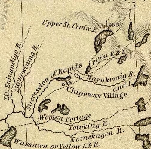
Detail of the upper Saint Croix River, Brule Bog portage, and “Chipeway Village” from Hydrographical Basin of the Upper Mississippi River From Astronomical and Barometrical Observations Surveys and Information by J.N. Nicollet, 1843. Also shown is the Grand Footpath (long dotted line) between Chequamegon Bay and Saint Anthony Falls.
~ David Rumsey Map Collection
We soon began to meet large parties of Indians in their canoes, bound to La Pointe, to be present at the payment. As Mr. Hays (the Indian agent at La Pointe) had told us that he expected the Rev. Mr. Ely, who had charge of a Presbyterian missionary station on the Percagaman, or Snake river, to be over at the payment, and thought it probable that we might meet him; and learning that some of the Indians we met were from Snake river, I asked them if they knew whether Mr. Ely had left. They told me he had, and that he was at his camp down the river, which we would soon reach.
We continued on, amidst fields of wild rice in full bloom, which covered the lake for acres upon acres on each side of the channel. This wild rice (rizania aquatica) is of great importance to the Indians, who gather large quantities of it when ripe, in autumn, for their winter food. Its soft stem and watery roots are immersed about 2 to 2½ feet under water, while the blades, head, and stalk reach about a foot to a foot and a half above water. In flowering, its heads present a singular appearance. Its pistils, or grain part of the flower, are clustered on a long, sharp-pointed spicular, terminating in a sharp cone at the very head of the stalk; while the pollen appears attached to the stalk below the head.
Why could not this rice be sown and cultivated in the lakes of western New York and in New England? Besides the value of the grain for poultry and various other purposes, its tops or blades would make the richest and sweetest fodder for cattle. I chewed the blades, and found them tender, and as sweet as the tender blades of green corn. The experiment might be worth the trial.

Reverend Edmund Franklin Ely.
~ Duluth Public Library
About the middle of the afternoon we reached the first rapids in descending the St. Croix, now contracted from a lake into a narrow river, strewed here and there with black boulders of trap. We here had the pleasure of finding Mr. Ely encamped on the west bank of the river, who had remained still all day, as it was Sunday. He had in company with him the Rev. Mr. Rosselle, a young clergyman from Ogdensburg, New York, to whom he introduced me. Mr. Rosselle informed me that he had been to the falls of St. Anthony, from whence he had gone on a steamboat “Still-water,” at the head of the lower Lake St. Croix, and from thence to the missionary station on the Pergacaman, or Snake river, where he concluded to accompany the Rev. Mr. Ely to La Pointe, and be present at the Indian payment. From La pointe he expected to make his way home by the Sault St. Marie, Mackinac, &c. Mr. Ely had some Indians along with him, who were evidently attached to the mission. He said the success of the mission had been interfered with, to some extend, by the dread in which the Chippewas held the Sioux in that part of the country; that in constant fear of their natural enemy, they disliked making permanent settlements and to improve them. After some other general conversation, we continued our journey over rapids, till near night, when we camped (as was often the case) on an old Indian camping-ground, and saw lying about us dog bones, on the meat of which the Indians had feasted. An innumerable swarm of horseflies surrounded our tent and camp-fire, which the voyageurs at first mistook for bumble bees, whose nest, they conceived, they had disturbed, and, for fear of being stung, they fled; but, on ascertaining they were merely noisy flies, they came back again.
We made an early start next morning, to resume our descent over rapids dashing over trap and granite boulders. We met a half-breed and his wife, who had a keg of whiskey in his canoe. They were going to La Pointe, where Mr. Hays suffers no liquor to land. The man offered to treat my voyageurs, one of whom was known to him. I consented that they might take one dram each, but no more. This being given them, we thanked him, and proceeded on our journey. About noon, we passed the last severe rapids, and the mouth of a large tributary from the east, called the Macagon, about 100 miles above the falls, and within 50 miles of Snake river.

Detail of the Saint Croix River with tributaries Snake River and Kettle River from Hydrographical Basin of the Upper Mississippi River From Astronomical and Barometrical Observations Surveys and Information by J.N. Nicollet, 1843. Also shown is the Grand Footpath (long dotted line) between Chequamegon Bay and Saint Anthony Falls.
~ David Rumsey Map Collection
The St. Croix, from this point down, became a larger, more beautiful, and more interesting stream. The bottoms, too, became wide and rich, but subject to inundation at very high water. The stratified red sandstone was seen to skirt the margins of the river, all along the rapids; while boulders of trap and granite were strewn over the centre of the channel. But, as we approached Kettle and Snake rivers, we began to notice the appearance of white sandstone on the shores of the river, which continued to appear till near the falls, and again rose in high cliffs below them, and continued to the Mississippi. At night, we camped on a high pine bluff on the right bank of the river, a large swamp being on the opposite side. Here we were nearly devoured by mosquitoes, and were glad to make our escape next morning without breakfast – intending to stop and cook at a place, if possible, less infested by them; which we did, on the pebbly beach of an island.
We had a showery forenoon, but continued our journey. We met with several long rapids, and, passing Kettle river, reached the mouth of Snake river, about 10 a.m. – where we found a body of Indians encamped, going to La Pointe. We exchanged some meal for some fish, and gave an old woman some sugar for a sick child. Then, wishing them a “bon voyage,” we put off. About 25 miles above the falls, we passed Sunrise river, with splendid and extensive bottom-land opposite to it on the left bank, lying high and dry above high-water mark.
The next place we made was Wolf river, about 18 or 20 miles above the falls. Here we found a rude village, on a rich piece of land, settled by half-breeds, Indians, and a Frenchman or two. They had lots of liquor, and offered to sell me some; but I declined to purchase, or to let my voyageurs buy any; and, though late in the afternoon, moved for some 8 or 10 miles further, and camped just within the first rapid or two, at the commencement of the falls. From the head of the rapids to the falls is 9 miles.

Detail of Saint Croix Falls with tributaries Sunrise River (“Memokage”) and Wolf Creek (“Attanwa”) from Hydrographical Basin of the Upper Mississippi River From Astronomical and Barometrical Observations Surveys and Information by J.N. Nicollet, 1843. Also shown is the Grand Footpath (long dotted line) between Chequamegon Bay and Saint Anthony Falls.
~ David Rumsey Map Collection
~ Fifty Years in the Northwest by William H. C. Folsom, 1888, page 87.
We reached the falls next morning to breakfast, where I made the acquaintance of Mr. Purinton, to whom I bore a letter of introduction, and found him a very clever and enterprising man. He has done more to develop this part of the country, and to enhance its value and settlement, than any other man in it. The falls afford a splendid water-power, fully equal to that yielded by the falls of the Merrimac at Lowell. Mr. Purinton is the proprietor, and has a saw-mill running with five saws, in separate frames. His logs come down the St. Croix.
There is a trap formation in place, crossing the river at the falls, obliquely from northwest to southeast. It is lost a short distance to the northwest of the river, but runs off in a range of 20 miles to the southeast of the falls. It differs a good deal from the trap-formation on Lake Superior. It is of a bluish and lighter color than the trap on the lake in the high perpendicular cliffs of this stone, which faces the river at, and for some little distance below the falls, may be seen strong indications of a columnar structure in its form; while in the trap on Lake Superior, the same rock is uniformly amorphous in its form.
Besides, the trap on Lake Superior appears uniformly to have had an upheaval through red sandstone; while that at the falls has been borne up through white sandstone, very distinct in its character from the red sandstone of the lake. It is probable, therefore, that there is no continuous connexion or homogeneousness of character between the trap-rock of the falls, and that on Lake Superior; and that they may have been raised at far different and distinct periods. Be this as it may, however, I found the trap at the falls of St. Croix to give very favorable indications of the existence of copper ore. Mr. Purinton gave me some very interesting specimens of the ore found in the vicinity of his mill.
While rambling about the falls, I discovered, also, one or two very fine mineral chalybeate springs.

Detail of the Saint Croix River from the Falls to the head of Saint Croix Lake (Stillwater, Minnesota) from Hydrographical Basin of the Upper Mississippi River From Astronomical and Barometrical Observations Surveys and Information by J.N. Nicollet, 1843. Also shown is the Grand Footpath (long dotted line) between Chequamegon Bay and Saint Anthony Falls (Minneapolis, Minnesota.
~ David Rumsey Map Collection
Having paid off my voyageurs at the falls, and sent them back in one of the canoes, I prepared to descend the river to the head of the lake, or to Stillwater, in the other; which I reached next day. There is a saw-mill at this place, and two others between it and the falls – all being turned by streams which enter the river on one side or the other. At Stillwater, a town not quite a year old, there is a tavern, two stores, a blacksmith-shop, one lawyer, one doctor, no preacher, no schoolmaster, no justice of the peace or mayor, one saw-mill, no school, a large cool spring, and a very pretty place for the town to grow on. We here met the steamboat Lynx, on which we took passage, after disposing of my canoe.
The land on the west side of Lake St. Croix is beautiful all the way to the Mississippi, and is fast settling up. This beautiful sheet of water is 22 miles long, and from one and a half to two miles wide.
I am, very respectfully and sincerely, yours,
MORGAN.
To be continued in Copper Harbor Redux…
This post is on of several that seeks to determine how many images exist of Great Buffalo, the famous La Pointe Ojibwe chief who died in 1855. To learn why this is necessary, read this post introducing the Great Chief Buffalo Picture Search.
Today’s post looks at two paintings from the 1820s of Ojibwe men named Bizhiki (Buffalo). The originals are lost forever, but the images still exist in the lithographs that follow.

Pee-che-kir: A Chippewa Chief Lithograph from McKenney and Hall’s History of the Indian Tribes of North America based on destroyed original by Charles Bird King; 1824. (Wikimedia Images)

Pe-shick-ee: A Celebrated Chippeway Chief from the Aboriginal Port-Folio by James Otto Lewis. The original painting was done by Lewis at Prairie du Chien or Fond du Lac of Lake Superior in 1825 or 1826 (Wisconsin Historical Society).
1824 Delegation to Washington
Chronologically, the first known image to show an Ojibwe chief named Buffalo appeared in the mid-1820s at time when the Ojibwe and the United States government were still getting to know each other. Prior to the 1820s, the Americans viewed the Ojibwe as a large and powerful nation. They had an uncomfortably close history with the British, who were till lurking over the border in Canada, but they otherwise inhabited a remote country unfit for white settlement. To the Ojibwe, the Americans were chimookomaan, “long knives,” in reference to the swords carried by the military officers who were the first Americans to come into their country. It was one of these long knives, Thomas McKenney, who set in motion the gathering of hundreds of paintings of Indians. Two of these showed men named Buffalo (Bizhiki).

Charles Bird King: Self portrait 1815 (Wikimedia Images)
McKenney was appointed the first Superintendent of Indian Affairs in 1824. Indian Affairs was under the Department of War at that time, and McKenneyʼs men in the West were mostly soldiers. He, like many in his day, believed that the Indian nations of North America were destined for extinction within a matter of decades. To preserve a record of these peoples, he commissioned over 100 portraits of various Indian delegates who came to Washington from all over the U.S. states and territories. Most of the painting work fell to Charles Bird King, a skilled Washington portrait artist. Beginning in 1822, King painted Indian portraits for two decades. He would paint famous men like Black Hawk, Red Jacket, Joseph Brandt, and Major Ridge, but Kingʼs primary goal was not to record the stories of important individuals so much as it was to capture the look of a vanishing race.

No-tin copied from 1824 Charles Bird King original by Henry Inman. Noodin (Wind) was a prominent chief from the St. Croix country. King’s painting of Buffalo from St. Croix was probably also copied by Inman, but its location is unknown (Wikimedia Images).
In July of 1824, William Clark, the famous companion of Meriwether Lewis, brought a delegation of Sauks, Foxes, and Ioways to Washington to negotiate land cessions. Lawrence Taliaferro, the Indian agent at Fort St. Anthony (now Minneapolis), brought representatives of the Sioux, Menominee, and Ojibwe to observe the treaty process. The St. Croix chiefs Buffalo and Noodin (Wind) represented the Ojibwe.

Charles Bird King painted portraits of most of the Indians listed here in the the 1824 Washington group by Niles’ Weekly Register, July 31, 1824. (Google Books)
The St. Croix chiefs were treated well: taken to shows, and to visit the sights of the eastern cities. However, there was a more sinister motivation behind the governmentʼs actions. McKenney made sure the chiefs saw the size and scope of the U.S. Military facilities in Washington, the unspoken message being that resistance to American expansion was impossible. This message seems to have resonated with Buffalo and Noodin of St. Croix as it is referred to repeatedly in the official record. McKenney pointed Buffalo out as a witness to American power at the Treaty of Fond du Lac (1826). Schoolcraft and Allen mention Buffalo’s trip in their own ill-fated journey up the St. Croix in 1832 (see it in this post), and Noodin talks about the soldiers he saw in Washington in the treaty deliberations in the 1837 Treaty of St. Peters.
While in Washington, Buffalo, Noodin, and most of the other Indians in the group sat with King for portraits in oil. Buffalo was shown wearing a white shirt and cloak, holding a pipe, with his face painted red. The paintings were hung in the offices of the Department of War, and the chiefs returned to their villages.
James Otto Lewis
The following summer, St. Croix Buffalo and Noodin joined chiefs from villages throughout the Ojibwe country, as well as from the Sioux, Sac and Fox, Menominee, Ho-Chunk, Ioway, Ottawa, and Potawatomi at Prairie du Chien. The Americans had called them there to sign a treaty to establish firm borders between their nations. The stated goal was to end the wars between the Sioux and Ojibwe, but it also provided the government an opportunity to assert its authority over the country and to set the stage for future land cessions.
McKenney did not attend the Treaty of Prairie du Chien leaving it to Clark and Lewis Cass to act as commissioners. A quick scan of the Ojibwe signatories shows “Pee-see- ker or buffalo, St. Croix Band,” toward the bottom. Looking up to the third signature, we see “Gitspee Waskee, or le boeuf of la pointe lake Superior,” so both the St. Croix and La Pointe Buffalos were present among the dozens of signatures. One of the government witnesses listed was an artist from Philadelphia named James Otto Lewis. Over the several days of negotiation, Lewis painted scenes of the treaty grounds as well as portraits of various chiefs. These were sent back to Washington, some were copied and improved by King or other artists, and they were added to the collection of the War Department.
The following year, 1826, McKenney himself traveled to Fond du Lac at the western end of Lake Superior to make a new treaty with the Ojibwe concerning mineral exploration on the south shore. Lewis accompanied him and continued to create images. At some point in these two years, a Lewis portrait of an Ojibwe chief named Pe-schick-ee (Bizhiki) appeared in McKenneyʼs growing War Department collection.
Lithographs
By 1830, McKenney had been dismissed from his position and turned his attention to publishing a portfolio of lithographs from the paintings in the War Department collection. Hoping to cash in his own paintings by beating McKenney to the lithograph market, Lewis released The Aboriginal Port Folio in May of 1835. It included 72 color plates, one of which was Pe-schick-ee: A Celebrated Chippeway Chief.

Pencil sketch of Pee-che-kir by Charles Bird King. King made these sketches after his original paintings to assist in making copies. (Herman J. Viola, The Indian Legacy of Charles Bird King.)
Due to financial issues The History of the Indian Tribes of North America, by McKenney with James Hall, would not come out in full release until the mid 1840s. The three-volume work became a bestseller and included color plates of 120 Indians, 95 of which are accompanied by short biographies. Most of the lithographs were derived from works by King, but some were from Lewis and other artists. Kingʼs portrait of Pee-Che-Kir: A Chippewa Chief was included among them, unfortunately without a biography. However, we know its source as the painting of the St. Croix Buffalo in 1824. Noodin and several others from that delegation also made it into lithograph form. The original War Department paintings, including both Pee-Che-Kir and Pe-schick-ee were sent to the Smithsonian, where they were destroyed in a fire in 1858. Oil copies of some of the originals, including Henry Inmanʼs copy of Kingʼs portrait of Noodin, survive, but the lithographs remain the only known versions of the Buffalo portraits other than a pencil sketch of the head of Pee-Che-Kir done by King.
The man in the Lewis lithograph is difficult to identify. The only potential clue we get from the image itself is the title of “A Celebrated Chippeway Chief,” and information that it was painted at Prairie du Chien in 1825. To many, “celebrated” would indicate Buffalo from La Pointe, but in 1825, he was largely unknown to the Americans while the St. Croix Buffalo had been to Washington. In the 1820s, La Pointe Buffaloʼs stature was nowhere near what it would become. However, he was a noted speaker from a prominent family and his signature is featured prominently in the treaty. Any assumptions about which chief was more “celebrated” are difficult.
In dress and pose, the man painted by Lewis resembles the King portrait of St. Croix Buffalo. This has caused some to claim that the Lewis is simply the original version of the King. King did copy and improve several of Lewisʼ works, but the copies tended to preserve in some degree the grotesque, almost cartoonish, facial features that are characteristic of the self-taught Lewis (see this post for another Lewis portrait). The classically-trained King painted highly realistic faces, and side-by-side comparison of the lithographs shows very little facial resemblance between Kingʼs Pee-Che-Kir and Lewisʼ Pe-schick-ee.

Thomas L. McKenney painted in 1856 by Charles Loring Elliott (Wikimedia Images)
Of the 147 War Department Indian portraits cataloged by William J. Rhees of the Smithsonian prior to the fire, 26 are described as being painted by “King from Lewis,” all of which are from 1826 or after. Most of the rest are attributed solely to King. Almost all the members of the 1824 trip to Washington are represented in the catalog. “Pee-che-ker, Buffalo, Chief of the Chippeways.” does not have an artist listed, but Noodin and several of the others from the 1824 group are listed as King, and it is safe to assume Buffalo’s should be as well. The published lithograph of Pee-che-kir was attributed solely to King, and not “King from Lewis” as others are. This further suggests that the two Buffalo lithographs are separate portraits from separate sittings, and potentially of separate chiefs.
Even without all this evidence, we can be confident that the King is not a copy of the Lewis because the King portrait was painted in 1824, and the Lewis was painted no earlier than 1825. There is, however, some debate about when the Lewis was painted. From the historical record, we know that Lewis was present at both Prairie du Chien and Fond du Lac along with both the La Pointe Buffalo and the St. Croix Buffalo. When Pe- schick-ee was released, Lewis identified it as being painted at Prairie du Chien. However, the work has also been placed at Fond du Lac.
The modern identification of Pee-che-kir as a copy of Pe-schick-ee seems to have originated with the work of James D. Horan. In his 1972 book, The McKenney-Hall Portrait Gallery of American Indians, he reproduces all the images from History of the Indian Tribes, and adds his own analysis. On page 206, he describes the King portrait of Pee-che-kir with:
“Peechekir (or Peechekor, Buffalo) was “a solid, straight formed Indian,” Colonel McKenney recalled many years after the Fond du Lac treaty where he had met the chief. Apparently the Chippewa played a minor role at the council.
Original by James Otto Lewis, Fond du Lac council, 1826, later copied in Washington by Charles Bird King.”
Presumably, the original he refers to would be the Lewis portrait of Pe-schick-ee. However, Horanʼs statement that McKenney met St. Croix Buffalo at Fond du Lac is false. As we already know, the two men met in 1824 in Washington. It is puzzling how Horan did not know this considering he includes the following account on page 68:
The first Indian to step out of the closely packed lines of stone-faced red men made McKenney feel at home; it was a chief he had met a few years before in Washington. The Indian held up his hand in a sign of peace and called out:
“Washigton [sic]… Washington… McKenney shook hands with the chief and nodded to Lewis but the artist had already started to sketch.”
McKenneyʼs original account identifies this chief as none other than St. Croix Buffalo:
In half an hour after, another band came in who commenced, as did the others, by shaking hands, followed, of course, by smoking. In this second band I recognized Pee-che-kee, or rather he recognized me–a chief who had been at Washington, and whose likeness hangs in my office there. I noticed that his eye was upon me, and that he smiled, and was busily employed speaking to an Indian who sat beside him, and no doubt about me. His first word on coming up to speak to me was, “Washington”–pointing to the east. The substance of his address was, that he was glad to see me–he felt his heart jump when he first saw me–it made him think of Washington, of his great father, of the good living he had when he visited us–how kind we all were to him, and that he should never forget any of it.
From this, Horan should have known not only that the two men knew each other, but also that a portrait of the chief (Kingʼs) already was part of the War Department collection and therefore existed before the Lewis portrait. Horanʼs description of Lewis already beginning his sketch does not appear in McKenneyʼs account and seems to invented. This is not the only instance where Horan confuses facts or takes wide license with Ojibwe history. His statement quoted above that the Ojibwe “played a minor role” in the Treaty of Fond du Lac, when they were the only Indian nation present and greatly outnumbered the Americans, should disqualify Horan from being treated as any kind of authority on the topic. However, he is not the only one to place the Lewis portrait of Pe-schick-ee at Fond du Lac rather than Prairie du Chien.
Between, 1835 and 1838 Lewis released 80 lithographs, mostly of individual Indians, in a set of ten installments. He had intended to include an eleventh with biographies. However, a dispute with the publisher prevented the final installment from coming out immediately. His London edition, released in 1844 by another publisher, included a few short biographies but none for Pe-schick-ee. Most scholars assumed that he never released the promised eleventh installment. However, one copy of a self-published 1850 pamphlet donated by Lewisʼs grandson exists in the Free Library of Philadelphia. In it are the remaining biographies. Number 30 reads:
No. 30. Pe-shisk-Kee. A Chippewa warrior from Lake Huron, noted for his attachment to the British, with whom he always sided. At the treaty held at Fond du Lac, when the Council opened, he appeared with a British medal of George the III. on his breast, and carrying a British flag, which Gen. Cass, one of the Commissioners, promptly and indignantly placed under his feet, and pointing to the stars and stripes, floating above them, informed him that that was the only one permitted to wave there.
The Chief haughtily refused to participate in the business of the Council, until, by gifts, he became partly conciliated, when he joined in their deliberations. Painted at Fond du Lac, in 1826.
This new evidence further clouds the story. Initially, this description does not seem to fit what we know about either the La Pointe or the St. Croix Buffalo, as both were born near Lake Superior and lived in Wisconsin. Both men were also inclined to be friendly toward the American government. The St. Croix Buffalo had recently been to Washington, and the La Pointe Buffalo frequently spoke of his desire for good relations with the United States in later years. It is also troubling that Lewis contradicts his earlier identification of the location of the portrait at Prairie du Chien.
It is unlikely that Pe-schick-ee depicts a third chief given that no men named Buffalo other than the two mentioned signed the Treaty of Fond du Lac, and the far-eastern bands of Ojibwe from Lake Huron were not part of treaty councils with the Lake Superior bands. One can speculate that perhaps Lewis, writing 25 years after the original painting, mistook the story of Pe-schick-ee with that one of the many other chiefs he met in his travels, but there are some suggestions that it might, in fact, be La Pointe Buffalo.
The La Pointe Band traded with the British in the other side of Lake Superior for years after the War of 1812 supposedly confirmed Chequamegon as American territory. If you’ve read this post, you’ll know that Buffalo from La Pointe was a follower of Tenskwatawa, whose brother Tecumseh fought beside the British. On July 22, 1822, Schoolcraft writes:
At that place [Chequamegon] lived, in comparatively modern times, Wabojeeg and Andaigweos, and there still lives one of their descendants in Gitchee Waishkee, the Great First-born, or, as he is familiarly called, Pezhickee, or the Buffalo, a chief decorated with British insignia. His band is estimated at one hundred and eighteen souls, of whom thirty-four are adult males, forty-one females, and forty-three children.
It’s possible that it was La Pointe Buffalo with the British flag. Archival research into the Treaty of Fond du Lac could potentially clear this up. If I stumble across any, I’ll be sure to add it here. For now, we can’t say one way or the other which Buffalo is in the Lewis portrait.
The Verdict
Not Chief Buffalo from La Pointe: This is Chief Buffalo from St. Croix.
Inconclusive: This could be Buffalo from La Pointe or Buffalo from St. Croix.
Sources:
Horan, James David, and Thomas Loraine McKenney. The McKenney-Hall Portrait Gallery of American Indians. New York, NY: Bramhall House, 1986. Print.
KAPPLER’S INDIAN AFFAIRS: LAWS AND TREATIES. Ed. Charles J. Kappler. Oklahoma State University Library, n.d. Web. 21 June 2012. <http:// digital.library.okstate.edu/Kappler/>.
Lewis, James O., The Aboriginal Port-Folio: A Collection of Portraits of the Most Celebrated Chiefs of the North American Indians. Philadelphia: J.O. Lewis, 1835-1838. Print.
———– Catalogue of the Indian Gallery,. New York: J.O. Lewis, 1850. Print.
Loew, Patty. Indian Nations of Wisconsin: Histories of Endurance and Renewal.
Madison: Wisconsin Historical Society, 2001. Print.
McKenney, Thomas Loraine. Sketches of a Tour to the Lakes of the Character and Customs of the Chippeway Indians, and of Incidents Connected with the Treaty of Fond Du Lac. Baltimore: F. Lucas, Jun’r., 1827. Print.
McKenney, Thomas Loraine, and James Hall. Biographical Sketches and Anecdotes of Ninety-five of 120 Principal Chiefs from the Indian Tribes of North America. Washington: U.S. Dept. of the Interior, Bureau of Indian Affairs, 1967. Print.
Moore, Robert J. Native Americans: A Portrait : The Art and Travels of Charles Bird King, George Catlin, and Karl Bodmer. New York: Stewart, Tabori & Chang, 1997. Print.
Niles, Hezekiah, William O. Niles, Jeremiah Hughes, and George Beatty, eds. “Indians.” Niles’ Weekly Register [Baltimore] 31 July 1824, Miscellaneous sec.: 363. Print.
Rhees, William J. An Account of the Smithsonian Institution. Washington: T. McGill, 1859. Print.
Satz, Ronald N. Chippewa Treaty Rights: The Reserved Rights of Wisconsin’s Chippewa Indians in Historical Perspective. Madison, WI: Wisconsin Academy of Sciences, Arts and Letters, 1991. Print.
Schoolcraft, Henry Rowe, and Philip P. Mason. Expedition to Lake Itasca; the Discovery of the Source of the Mississippi,. [East Lansing]: Michigan State UP, 1958. Print.
Schoolcraft, Henry R. Personal Memoirs of a Residence of Thirty Years with the Indian Tribes on the American Frontiers: With Brief Notices of Passing Events, Facts, and Opinions, A.D. 1812 to A.D. 1842. Philadelphia: Lippincott, Grambo and, 1851. Print.
Viola, Herman J. The Indian Legacy of Charles Bird King. Washington: Smithsonian Institution, 1976. Print.
Warren, William W., and Theresa M. Schenck. History of the Ojibway People. St. Paul: Minnesota Historical Society, 2009. Print.
Special thanks to Theresa Schenck of the University of Wisconsin and Charles Lippert for helping me work through this information, and to Michael Edmonds of the Wisconsin Historical Society, and Alice Cornell (formerly of the University of Cincinnati) for tracking down the single copy of the unpublished James Otto Lewis catalog.
Note: This is the final post of four about Lt. James Allen, his ten American soldiers and their experiences on the St. Croix and Brule rivers. They were sent from Sault Ste. Marie to accompany the 1832 expedition of Indian Agent Henry Schoolcraft to the source of the Mississippi River. Each of the posts gives some general information about the expedition and some pages from Allen’s journal.

- Sauk Chief Makataimeshekiakiah, or Black Hawk by Charles Bird King (Wikimedia Images)

On the night of August 1, 1831, the section of the Michigan Territory that would become the state of Wisconsin, was a scene of stark contrasts regarding the United States Army’s ability to force its will on Indian people. In the south, American forces had caught up and skirmished with the starving followers of Black Hawk near the mouth of the Bad Axe River in present-day Vernon County. The next morning, with the backing of the steamboat Warrior, the soldiers would slaughter dozens of men, women, and children as they tried to retreat across the Mississippi. The massacre at Bad Axe was the end of the Black Hawk War, the last major military resistance from the Indian nations of the Old Northwest.
Less than 300 miles upstream, Lieutenant James Allen had his bread stolen right out of his fire as he slept. Presumably, it was taken by Ojibwe youths from the Yellow River village on the St. Croix. Earlier that day, he had been unable to get convince any members of the Yellow River band to guide him up to the Brule River portage. The next morning, (the same day as the Battle of Bad Axe), Allen was able to buy a new bark canoe to take some load off his leaky fleet. However, the Ojibwe family that sold it to him was able to take advantage of supply and demand to get twice the amount of flour from the soldiers that they would’ve gotten from the local traders. Later that day, the well-known chief Gaa-bimabi (Kabamappa), from the upper St. Croix, brought him a desperately-needed map, so not all of his interactions with the Ojibwe that day were negative. However, each of these encounters showed clearly that the Ojibwe were neither cowed nor intimidated by the presence of American soldiers in their country.
In fact, Allen’s detachment must have been a miserable sight. They had fallen several days behind the voyageur-paddled canoes carrying Schoolcraft, the interpreter, and the doctor. Their canoes were leaking badly and they were running out of gum (pitch) to seal them up. Their feet were torn up from wading up the rapids, and one man was too injured to walk. They were running low on food, didn’t know how to find the Brule, and their morale was running dangerously low. If the War Department’s plan was for Allen to demonstrate American power to the Ojibwe, the plan had completely backfired.
The journey down the Brule was even more difficult for the soldiers than the trip up the St. Croix. I won’t repeat it all here because it’s in the posted pages of Allen’s journal in these four posts, but in the end, it was our old buddy Maangozid (see 4/14/13 post) and some other Fond du Lac Ojibwe who rescued the soldiers from their ordeal.
Allen’s journal entry after finally reaching Lake Superior is telling:
“[T]he management of bark canoes, of any size, in rapid rivers, is an art which it takes years to acquire; and, in this country, it is only possessed by Canadians [mix-blooded voyageurs] and Indians, whose habits of life have taught them but little else. The common soldiers of the army have no experience of this kind, and consequently, are not generally competent to transport themselves in this way; and whenever it is required to transport troops, by means of bark canoes, two Canadian voyageurs ought to be assigned to each canoe, one in the bow, and another in the stern; it will then be the safest and most expeditious method that can be adopted in this country.”
The 1830s were the years of Indian Removal throughout the United States, but at that time, the American government had no hope of conquering and subduing the Ojibwe militarily. When the Ojibwe did surrender their lands (in 1837 and 1842 for the Wisconsin parts), it was due to internal politics and economics rather than any serious threat of American invasion. Rather than proving the strength of the United States, Allen’s expedition revealed a serious weakness.
The Ojibwe weren’t overconfident or ignorant. The very word for Americans, chimookomaan (long knife), referred to soldiers. A handful of Ojibwe and mix-blooded warriors had fought the United States in the War of 1812 and earlier in the Ohio country. Bizhiki and Noodin, two chiefs whose territory Allen passed through on his ill-fated journey, had been to Washington in 1824 and saw the army firsthand. The next year, many more chiefs got to see the long knives in person at the Treaty of Prairie du Chien. Finally, the removal of their Ottawa and Potawatomi cousins and other nations to Indian Territory in the 1830s was a well-known topic of concern in Ojibwe villages. They knew the danger posed by American soldiers, but the reality of the Lake Superior Country in 1832 was that American power was very limited.
The journal picks up from part 3 with Allen and crew on the Brule River with their canoes in rapidly-deteriorating condition. They’ve made contact with the Fond du Lac villagers camped at the mouth, but there are still several obstacles to overcome.
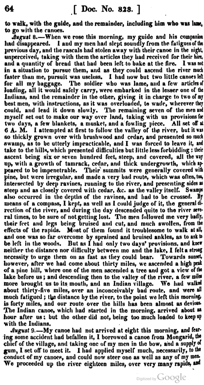
Doc. 323, pg. 66

Doc. 323, pg. 65

Doc. 323, pg. 66
Allen’s journal is part of Phillip P. Mason’s edition of Schoolcraft’s Expedition to Lake Itasca: The Discovery of the Source of the Mississippi (1958). However, these Google Books pages come from the original publication as part of the United States Congress Serial Set.

James Allen (1806-1846)
Collections of the Iowa Historical Society
Allen and all of his men survived the ordeal of the 1832 expedition. He returned to La Pointe on August 11 and left the next day with Dr. Houghton. The two men returned to the Soo together, stopping at the great copper rock on the Ontonagon River along the way.
On September 13, 1832, he wrote Alexander Macomb, his commander at Fort Brady. The letter officially complained about Schoolcraft “unnecessarily and injuriously” leaving the soldiers behind at the mouth of the St. Croix. When the New York American published its review of Schoolcraft’s Narrative on July 19, 1834, it expressed “indignation and dismay” at the “un-Christianlike” behavior of the agent for abandoning the soldiers in the “enemy’s country.” The resulting controversy forced Schoolcraft to defend himself in the Detroit Journal and Michigan Advertiser where he pointed out Allen’s map’s importance to the Narrative. He also reminded the public that the Ojibwe and the United States were considered allies.
James Allen went on to serve in Chicago and at the Sac and Fox agency in Iowa Territory. After the Mexican War broke out in 1846, he traveled to Utah and organized a Mormon Battalion to fight on the American side. He died on his way back east on August 23, 1846. He was only forty years old. (John Lindquist has great website about the career of James Allen with much more information about his post-1832 life).
Sources:
Ely, Edmund Franklin, and Theresa M. Schenck. The Ojibwe Journals of Edmund F. Ely, 1833-1849. Lincoln: University of Nebraska, 2012. Print.
Loew, Patty. Indian Nations of Wisconsin: Histories of Endurance and Renewal. Madison: Wisconsin Historical Society, 2001. Print.
Schoolcraft, Henry Rowe, and Philip P. Mason. Expedition to Lake Itasca; the Discovery of the Source of the Mississippi,. [East Lansing]: Michigan State UP, 1958. Print.
Warren, William W., and Theresa M. Schenck. History of the Ojibway People. St. Paul: Minnesota Historical Society, 2009. Print.
Witgen, Michael J. An Infinity of Nations: How the Native New World Shaped Early North America. Philadelphia: University of Pennsylvania, 2012. Print.
