Collected & edited by Amorin Mello
While researching original land records around Lake Superior, I stumbled upon a curious deed recorded at Sault Ste Marie during the final days of Michigan Territory before statehood commenced in 1837.
Saulte Ste Marie, Michigan Territory
Chippewa County
Register of Deeds
Book 1 of Deeds, Pages 64-65
Know all men by these presents, that I George Johnston of Saul Ste Marie, Michigan, for and in consideration of the sum of one hundred and twelve dollars and fifty cents, lawful money of the United States of American, to me in hand paid by James L Schoolcraft the receipt whereof is hereby acknowledged, do hereby and by these presents, absolutely and completely sell and convey unto James L Schoolcraft afore said, his heirs and assigns, all my right, title interest and claim in, and to the equal and undivided half of a certain property, being and situate at the Demoins rapids, between the Demoines and Mississippi rivers, the same being a certain portion of lands reserved for the Sac & Fox half breeds, by a treaty concluded at the city Washington, on the fourth day of August in the year of our Lord one thousand eight hundred and twenty four, which half breed claim was on the fifteenth day of February A.D. one thousand eight hundred and thirty six sold and conveyed to me in full by a deed from Louis Desognier, of the town of Penetanguishene, in the Home District, Province of Upper Canada, And for him said Schoolcraft, his heirs and executors and administrators, to have and to hold the said equal and undivided half of said premises forever, and I the said George Johnston for myself and my heirs, do by these presents agree to warrant and defend the title of said premises to said Schoolcraft and his heirs forever.

George Johnston
In witness whereof I have set my hand and seal on this Twenty second day of December in the year of our Lord one thousand eight hundred and thirty six.
George Johnston {S}
In presence of }
John M Hulbert }
County of Chippewa }
State of Michigan }
On the 24th day of December in the year of our Lord one thousand eight hundred and thirty six, before me Gabriel Franchère, one of the Justices of the peace for said County, personally came George Johnston, known to me as the same person, who signed and sealed the within instrument, and acknowledged the same to be his voluntary act and deed for the purposes therein mentioned.
In testimony whereof and being requested I hereunto subscribe my name and affix my seal on the day and year above written.
Gabriel Franchère {S}
———
January 10th 1837
A true copy from original
S R Wood
Register
Johnston along with his siblings and in-laws have written a wealth of interesting documents about the United States’ Indian Affairs with the Lake Superior Chippewa, such as the 1842 Lac Du Flambeau Reservation Boundaries. What makes this deed in today’s post especially interesting is how it involves land in Iowa reserved for Mixed Bloods from a different Tribe beyond the Lake Superior basin:
1824 Sauk & Fox Treaty at Washington, D.C.
ARTICLE 1st.
The Sock and Fox tribes or nations of Indians, by their deputations in council assembled, do hereby agree, in consideration of certain sums of money, &c. to be paid to the said Sock and Fox tribes, by the Government of the United States, as hereinafter stipulated, to cede and for ever quit claim, and do, in behalf of their said tribes or nations, hereby cede, relinquish, and forever quit claim, unto the United States, all right, title, interest, and claim, to the lands which the said Sock and Fox tribes have, or claim, within the limits of the state of Missouri, which are situated, lying, and being, between the Mississippi and Missouri rivers, and a line running from the Missouri, at the entrance of Kansas river, north one hundred miles to the Northwest corner of the state of Missouri, and from thence east to the Mississippi. It being understood, that the small tract of land lying between the rivers Desmoin and the Mississippi, and the section of the above line between the Mississippi and the Desmoin, is intended for the use of the half-breeds belonging to the Sock and Fox nations; they holding it, however, by the same title, and in the same manner, that other Indian titles are held.
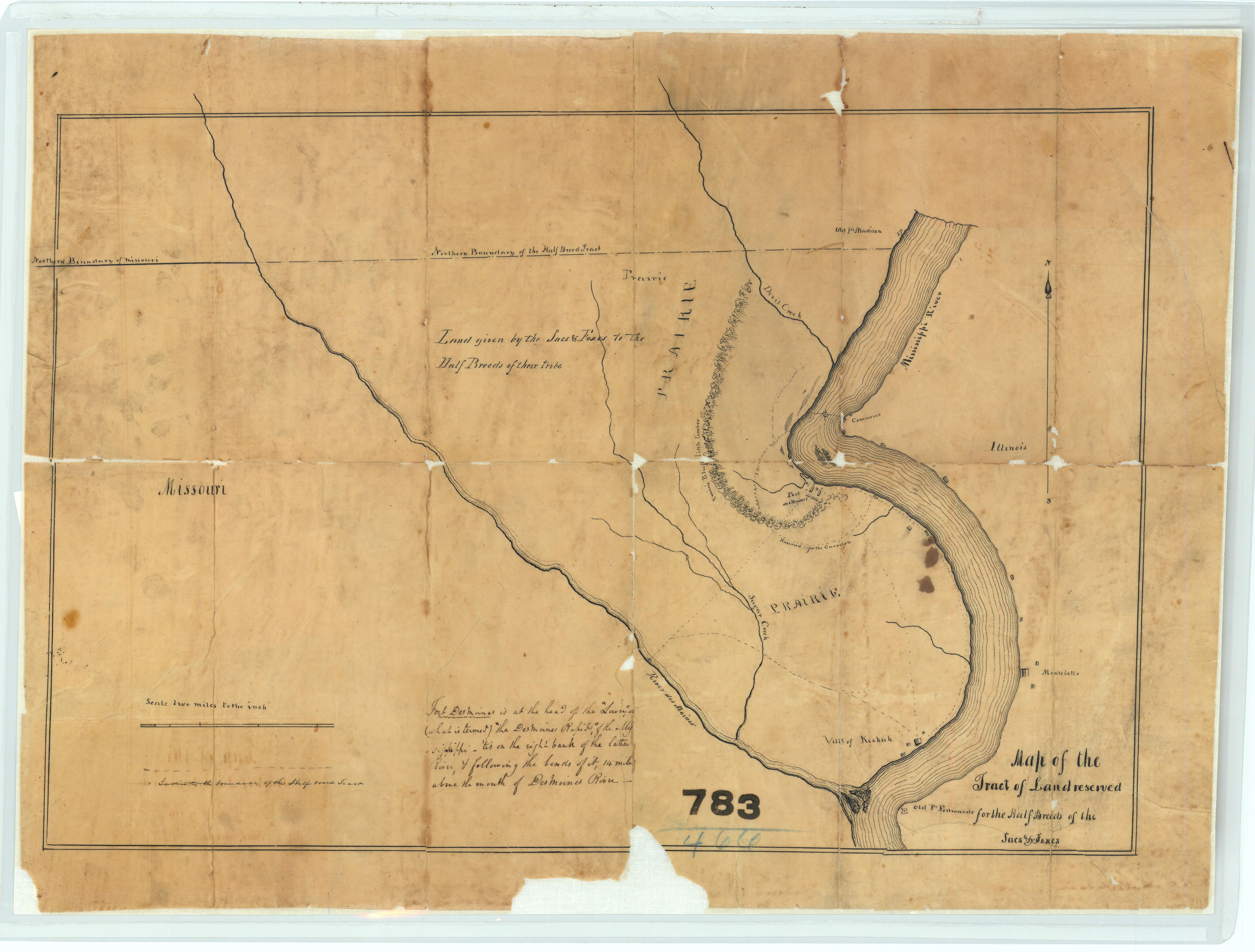
Map of the Tract of Land Reserved for the ‘Half-Breeds’ of the Sacs and Foxes in of Iowa
“This map is further titled ‘Land given by the Sacs and Foxes to the Half-Breeds of their tribe.’ This map also shows Fort Desmoines and portions of the Des Moines River and the Mississippi River.”
~ National Archives (NAID: 232924203)
This so-called “Iowa Half Breed Tract“ of 119,000 acres was originally reserved from sale and set aside for the mixed blood relations of Sauk & Fox nations to occupy, and individuals were prohibited from buying or selling any of this land. However, Congress removed this restriction in 1834, allowing individuals to buy and sell the land, which then fell out of tribal control into the hands of squatters and speculators. For more information, I recommend the May 2019 thesis “Half-breeds,” squatters, land speculators, and settler colonialism in the Des Moines-Mississippi confluence by Matthew Hill at University of Northern Iowa.
Long story short: At face value this deed appears to be completely unrelated to Chequamegon History, yet contains many familiar topics. Johnston’s understanding of Treaty promises to Tribal Mixed Bloods broken by the United States, and Johnston’s influence at later Treaty negotiations between the Lake Superior Chippewa and the United States may never been fully known, but are questions that deserve to be asked.
1827 Deed for Old La Pointe
December 27, 2022
Collected & edited by Amorin Mello
Chief Buffalo and other principal men for the La Pointe Bands of Lake Superior Chippewa began signing treaties with the United States at the 1825 Treaty of Prairie Du Chien; followed by the 1826 Treaty of Fond Du Lac, which reserved Tribal Trust Lands for Chippewa Mixed Bloods along the St. Mary’s River between Lake Superior and Lake Huron:
ARTICLE 4.
The Indian Trade & Intercourse Act of 1790 was the United States of America’s first law regulating tribal land interests:
SEC. 4. And be it enacted and declared, That no sale of lands made by any Indians, or any nation or tribe of Indians the United States, shall be valid to any person or persons, or to any state, whether having the right of pre-emption to such lands or not, unless the same shall be made and duly executed at some public treaty, held under the authority of the United States.
It being deemed important that the half-breeds, scattered through this extensive country, should be stimulated to exertion and improvement by the possession of permanent property and fixed residences, the Chippewa tribe, in consideration of the affection they bear to these persons, and of the interest which they feel in their welfare, grant to each of the persons described in the schedule hereunto annexed, being half-breeds and Chippewas by descent, and it being understood that the schedule includes all of this description who are attached to the Government of the United States, six hundred and forty acres of land, to be located, under the direction of the President of the United States, upon the islands and shore of the St. Mary’s river, wherever good land enough for this purpose can be found; and as soon as such locations are made, the jurisdiction and soil thereof are hereby ceded. It is the intention of the parties, that, where circumstances will permit, the grants be surveyed in the ancient French manner, bounding not less than six arpens, nor more than ten, upon the river, and running back for quantity; and that where this cannot be done, such grants be surveyed in any manner the President may direct. The locations for Oshauguscodaywayqua and her descendents shall be adjoining the lower part of the military reservation, and upon the head of Sugar Island. The persons to whom grants are made shall not have the privilege of conveying the same, without the permission of the President.
The aforementioned Schedule annexed to the 1826 Treaty of Fond du Lac included (among other Chippewa Mixed Blood families at La Pointe) the families of Madeline & Michel Cadotte, Sr. and their American son-in-laws, the brothers Truman A. Warren and Lyman M. Warren:
-
To Michael Cadotte, senior, son of Equawaice, one section.
-
To Equaysay way, wife of Michael Cadotte, senior, and to each of her children living within the United States, one section.
-
To each of the children of Charlotte Warren, widow of the late Truman A. Warren, one section.
-
To Ossinahjeeunoqua, wife of Michael Cadotte, Jr. and each of her children, one section.
-
To each of the children of Ugwudaushee, by the late Truman A. Warren, one section.
-
To William Warren, son of Lyman M. Warren, and Mary Cadotte, one section.

Detail of Michilimackinac County circa 1818 from Michigan as a territory 1805-1837 by C.A. Burkhart, 1926.
~ UW-Milwaukee Libraries
Now, if it seems odd for a Treaty in Minnesota (Fond du Lac) to give families in Wisconsin (La Pointe) lots of land in Michigan (Sault Ste Marie), just remember that these places were relatively ‘close’ to each other in the sociopolitical fabric of Michigan Territory back in 1827. All three places were in Michilimackinac County (seated at Michilimackinac) until 1826, when they were carved off together as part of the newly formed Chippewa County (seated at Sault Ste Marie). Lake Superior remained Unceded Territory until later decades when land cessions were negotiated in the 1836, 1837, 1842, and 1854 Treaties.
Ultimately, the United States removed the aforementioned Schedule from the 1826 Treaty before ratification in 1827.
Several months later, at Michilimackinac, Madeline & Michel Cadotte, Sr. recorded the following Deed to reserve 2,000 acres surrounding the old French Forts of La Pointe to benefit future generations of their family.
Register of Deeds
Michilimackinac County
Book A of Deeds, Pages 221-224

Michel Cadotte and
Magdalen Cadotte
to
Lyman M. Warren
~Deed.
Received for Record
July 26th 1827 at two Six O’Clock A.M.
J.P. King
Reg’r Probate

Bizhiki (Buffalo), Gimiwan (Rain), Kaubuzoway, Wyauweenind, and Bikwaakodowaanzige (Ball of Dye) signed the 1826 Treaty of Fond Du Lac as the Chief and principal men of La Pointe.

“Copy of 1834 map of La Pointe by Lyman M. Warren“ at Wisconsin Historical Society. Original map (not shown here) is in the American Fur Company papers of the New York Historical Society.
Whereas the Chief and principal men of the Chippeway Tribe of indians, residing on and in the parts adjacent to the island called Magdalen in the western part of Lake Superior, heretofore released and confirmed by Deed unto Magdalen Cadotte a Chippeway of the said tribe, and to her brothers and sisters as tenants in common, thereon, all that part of the said Island called Magdalen, lying south and west of a line commencing on the eastern shore of said Island in the outlet of Great Wing river, and running directly thence westerly to the centre of Sandy bay on the western side of said Island;
and whereas the said brothers and sisters of said Magdalen Cadotte being tenants in common of the said premises, thereafterwards, heretofore, released, conveyed and confirmed unto their sister, the said Magdalen Cadotte all their respective rights title, interest and claim in and to said premises,
and whereas the said Magdalen Cadotte is desirous of securing a portion of said premises to her five grand children viz; George Warren, Edward Warren and Nancy Warren children of her daughter Charlotte Warren, by Truman A. Warren late a trader at said island, deceased, and William Warren and Truman A. Warren children of her daughter Mary Warren by Lyman M. Warren now a trader at said Island;
and whereas the said Magdalen Cadotte is desirous to promote the establishment of a mission on said Island, by and under the direction, patronage and government of the American board of commissioners for foreign missions, according to the plan, wages, and principles and purposes of the said Board.

William Whipple Warren was one of the beneficiary grandchildren named in this Deed.
Now therefore, Know all men by these presents that we Michael Cadotte and Magdalen Cadotte, wife of the said Michael, of said Magdalen Island, in Lake Superior, for and in consideration of one dollar to us in hand paid by Lyman M. Warren, the receipt whereof is hereby acknowledged, and for and in consideration of the natural love and affection we bear to our Grandchildren, the said George, Edward, Nancy, William W., and Truman A. Warren, children of our said daughters Charlotte and Mary;
and the further consideration of our great desire to promote the establishment of a mission as aforesaid, under and by the direction, government and patronage of Board aforesaid, have granted, bargained, sold, released, conveyed and confirmed, and by these presents do grant, bargain, sell, release, convey and confirm unto the said Lyman M. Warren his heirs and assigns, out of the aforerecited premises and as part and parcel thereof a certain tract of land on Magdalen Island in Lake Superior, bounded as follows,
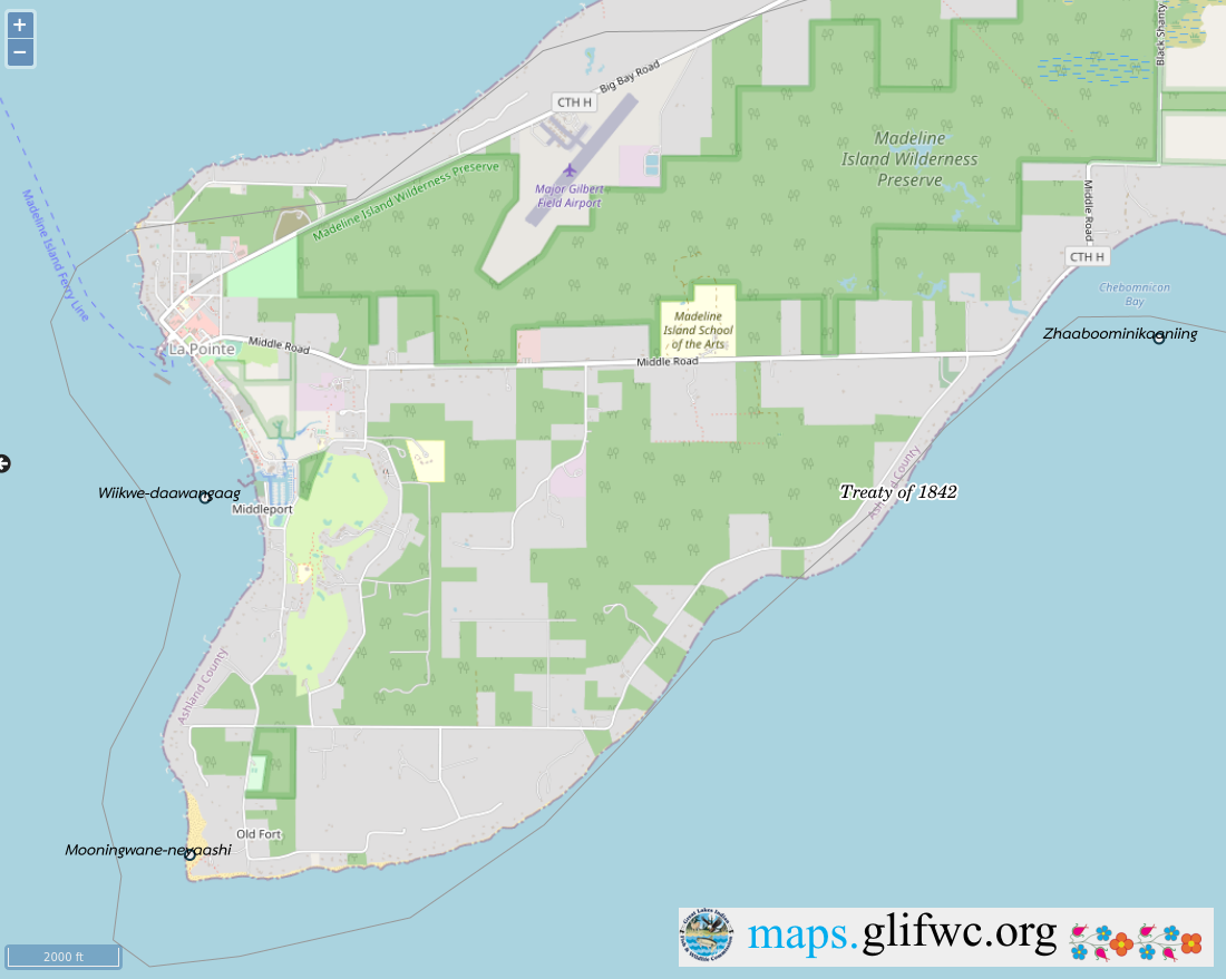
Detail of Ojibwemowin placenames on GLIFWC’s webmap.
that is to say, beginning at the most southeasterly corner of the house built and now occupied by said Lyman M. Warren, on the south shore of said Island between this tract and the land of the grantor, thence on the east by a line drawn northerly until it shall intersect at right angles a line drawn westerly from the mouth of Great Wing River to the Centre of Sandy Bay, thence on the north by the last mentioned line westward to a Point in said line, from which a line drawn southward and at right angles therewith would fall on the site of the old fort, so called on the southerly side of said Island; thence on the west by a line drawn from said point and parallel to the eastern boundary of said tract, to the Site of the old fort, so called, thence by the course of the Shore of old Fort Bay to the portage; thence by a line drawn eastwardly to the place of beginning, containing by estimation two thousand acres, be the same more or less, with the appurtenances, hereditaments, and privileges thereto belonging.
To have and to hold the said granted premises to him the said Lyman M. Warren his heirs and assigns: In Trust, Nevertheless, and upon this express condition, that whensoever the said American Board of Commissioners for foreign missions shall establish a mission on said premises, upon the plan, usages, principles and purposes as aforesaid, the said Lyman M. Warren shall forthwith convey unto the american board of commissioners for foreign missions, not less than one quarter nor more than one half of said tract herein conveyed to him, and to be divided by a line drawn from a point in the southern shore of said Island, northerly and parallel with the east line of said tract, and until it intersects the north line thereof.

Roughly 2,100 acres lies south of Middle Road.
And as to the residue of the said Estate, the said Lyman M. Warren shall divided the same equally with and amongst the said five children, as tenants in common, and not as joint tenants; and the grantors hereby authorize the said Lyman M. Warren with full powers to fulfil said trust herein created, hereby ratifying and confirming the deed and deeds of said premises he may make for the purpose ~~~
In witness whereof we have hereunto set our respective hands, this twenty fifth day of july A.D. one thousand eight hundred and twenty seven, of Independence the fifty first.
(Signed) Michel Cadotte {Seal}
Magdalen Cadotte X her mark {Seal}
Signed, Sealed and delivered
in presence of us }
Daniel Dingley
Samuel Ashman
Wm. M. Ferry
(on the third page and ninth line from the top the word eastwardly was interlined and from that word the three following lines and part of the fourth to the words “to the place” were erased before the signing & witnessing of this instrument.)
~~~~~~
Territory of Michigan }
County of Michilimackinac }
Be it known that on the twenty sixth day of July A.D. 1827, personally came before me, the subscriber, one of the Justices of the Peace for the County of Michilimackinac, Michel Cadotte and Magdalen Cadotte, wife of the said Michel Cadotte, and the said Magdalen being examined separate and apart from her said husband, each severally acknowledged the foregoing instrument to be their voluntary act and deed for the uses and purposes therein expressed.
