Collected & edited by Amorin Mello
While researching original land records around Lake Superior, I stumbled upon a curious deed recorded at Sault Ste Marie during the final days of Michigan Territory before statehood commenced in 1837.
Saulte Ste Marie, Michigan Territory
Chippewa County
Register of Deeds
Book 1 of Deeds, Pages 64-65
Know all men by these presents, that I George Johnston of Saul Ste Marie, Michigan, for and in consideration of the sum of one hundred and twelve dollars and fifty cents, lawful money of the United States of American, to me in hand paid by James L Schoolcraft the receipt whereof is hereby acknowledged, do hereby and by these presents, absolutely and completely sell and convey unto James L Schoolcraft afore said, his heirs and assigns, all my right, title interest and claim in, and to the equal and undivided half of a certain property, being and situate at the Demoins rapids, between the Demoines and Mississippi rivers, the same being a certain portion of lands reserved for the Sac & Fox half breeds, by a treaty concluded at the city Washington, on the fourth day of August in the year of our Lord one thousand eight hundred and twenty four, which half breed claim was on the fifteenth day of February A.D. one thousand eight hundred and thirty six sold and conveyed to me in full by a deed from Louis Desognier, of the town of Penetanguishene, in the Home District, Province of Upper Canada, And for him said Schoolcraft, his heirs and executors and administrators, to have and to hold the said equal and undivided half of said premises forever, and I the said George Johnston for myself and my heirs, do by these presents agree to warrant and defend the title of said premises to said Schoolcraft and his heirs forever.

George Johnston
In witness whereof I have set my hand and seal on this Twenty second day of December in the year of our Lord one thousand eight hundred and thirty six.
George Johnston {S}
In presence of }
John M Hulbert }
County of Chippewa }
State of Michigan }
On the 24th day of December in the year of our Lord one thousand eight hundred and thirty six, before me Gabriel Franchère, one of the Justices of the peace for said County, personally came George Johnston, known to me as the same person, who signed and sealed the within instrument, and acknowledged the same to be his voluntary act and deed for the purposes therein mentioned.
In testimony whereof and being requested I hereunto subscribe my name and affix my seal on the day and year above written.
Gabriel Franchère {S}
———
January 10th 1837
A true copy from original
S R Wood
Register
Johnston along with his siblings and in-laws have written a wealth of interesting documents about the United States’ Indian Affairs with the Lake Superior Chippewa, such as the 1842 Lac Du Flambeau Reservation Boundaries. What makes this deed in today’s post especially interesting is how it involves land in Iowa reserved for Mixed Bloods from a different Tribe beyond the Lake Superior basin:
1824 Sauk & Fox Treaty at Washington, D.C.
ARTICLE 1st.
The Sock and Fox tribes or nations of Indians, by their deputations in council assembled, do hereby agree, in consideration of certain sums of money, &c. to be paid to the said Sock and Fox tribes, by the Government of the United States, as hereinafter stipulated, to cede and for ever quit claim, and do, in behalf of their said tribes or nations, hereby cede, relinquish, and forever quit claim, unto the United States, all right, title, interest, and claim, to the lands which the said Sock and Fox tribes have, or claim, within the limits of the state of Missouri, which are situated, lying, and being, between the Mississippi and Missouri rivers, and a line running from the Missouri, at the entrance of Kansas river, north one hundred miles to the Northwest corner of the state of Missouri, and from thence east to the Mississippi. It being understood, that the small tract of land lying between the rivers Desmoin and the Mississippi, and the section of the above line between the Mississippi and the Desmoin, is intended for the use of the half-breeds belonging to the Sock and Fox nations; they holding it, however, by the same title, and in the same manner, that other Indian titles are held.
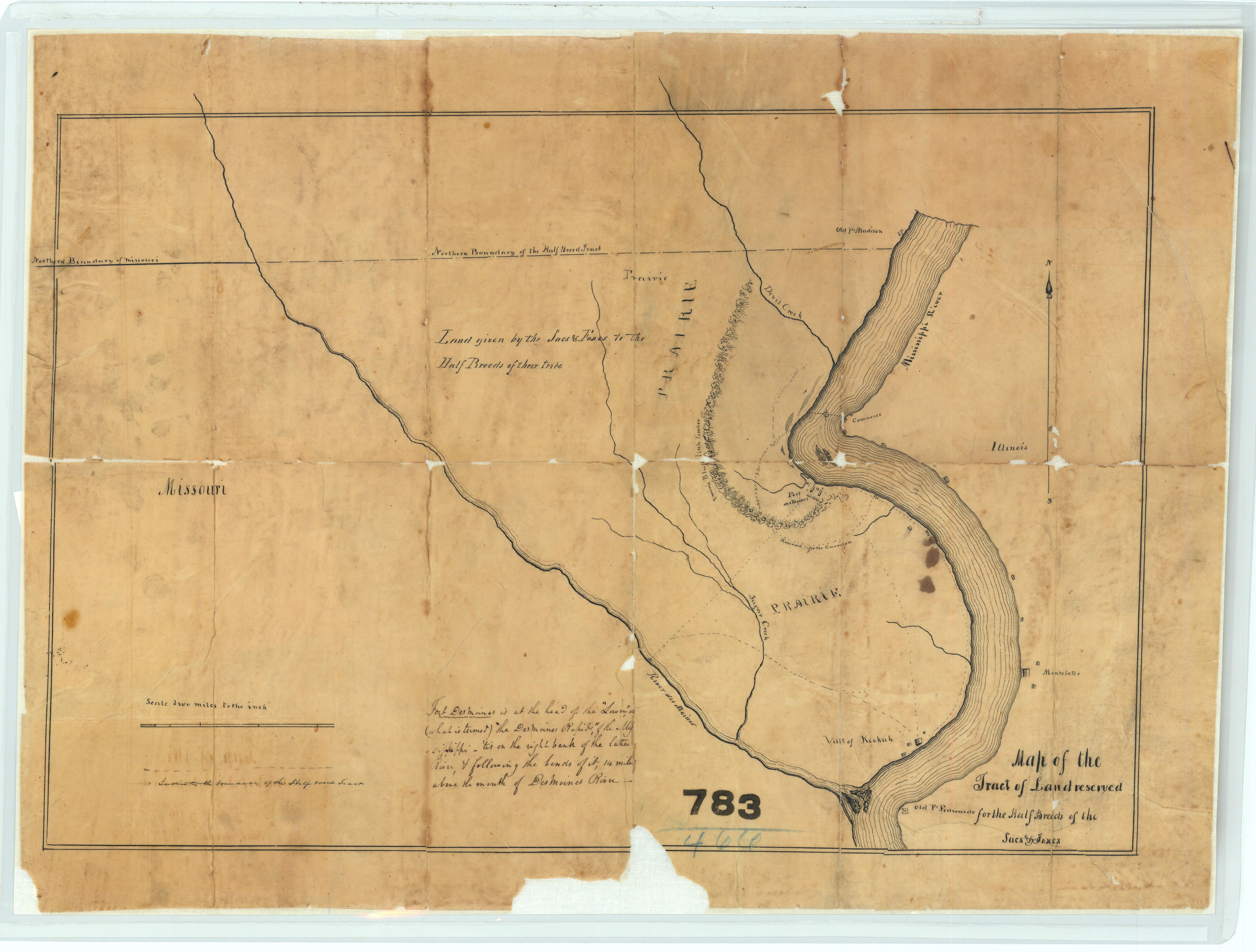
Map of the Tract of Land Reserved for the ‘Half-Breeds’ of the Sacs and Foxes in of Iowa
“This map is further titled ‘Land given by the Sacs and Foxes to the Half-Breeds of their tribe.’ This map also shows Fort Desmoines and portions of the Des Moines River and the Mississippi River.”
~ National Archives (NAID: 232924203)
This so-called “Iowa Half Breed Tract“ of 119,000 acres was originally reserved from sale and set aside for the mixed blood relations of Sauk & Fox nations to occupy, and individuals were prohibited from buying or selling any of this land. However, Congress removed this restriction in 1834, allowing individuals to buy and sell the land, which then fell out of tribal control into the hands of squatters and speculators. For more information, I recommend the May 2019 thesis “Half-breeds,” squatters, land speculators, and settler colonialism in the Des Moines-Mississippi confluence by Matthew Hill at University of Northern Iowa.
Long story short: At face value this deed appears to be completely unrelated to Chequamegon History, yet contains many familiar topics. Johnston’s understanding of Treaty promises to Tribal Mixed Bloods broken by the United States, and Johnston’s influence at later Treaty negotiations between the Lake Superior Chippewa and the United States may never been fully known, but are questions that deserve to be asked.
Fun With Maps
June 28, 2013
I’m someone who loves a good historical map, so one of my favorite websites is memory.loc.gov, the digital collections of the Library of Congress. You can spend hours zooming in on neat vintage maps. This post has snippets from eleven of them, stretching from 1674 to 1843. They are full of cool old inaccuracies, but they also highlight important historical trends and eras in our history. This should not be considered an exhaustive survey of the best maps out there, nor is it representative of all the LOC maps. Really, it’s just 11 semi-random maps with my observations on what I found interesting. Click on any map to go to the Library of Congress site where you can browse more of it. Enjoy:
French 1674
Nouvelle decouverte de plusieurs nations dans la Nouvelle France en l’année 1673 et 1674 by Louis Joliet. Joliet famously traveled from the Great Lakes down the Mississippi with the Jesuit Jacques Marquette in 1673.
- Cool trees.
- Baye des Puans: The French called the Ho-Chunk Puans, “Stinky People.” That was a translation of the Ojibwe word Wiinibiigoo (Winnebago), which means “stinky water people.” Green Bay is “green” in summer because of the stinky green algae that covers it. It’s not surprising that the Ho-Chunk no longer wish to be called the Winnebago or Puans.
- 8tagami: The French used 8 in Indian words for the English sound “W.” 8tagami (Odagami) is the Ojibwe/Odawa/Potawatomi word for the Meskwaki (Fox) People.
- Nations du Nord: To the French, the country between Lake Superior and Hudson Bay was the home of “an infinity of nations,” (check out this book by that title) small bands speaking dialects of Ojibwe, Cree, and Assiniboine Sioux.
- The Keweenaw is pretty small, but Lake Superior has generally the right shape.
French 1688
Carte de l’Amerique Septentrionnale by Jean Baptiste Louis Franquelin: Franquelin created dozens of maps as the royal cartographer and hydrographer of New France.
- Lake Superior is remarkably accurate for this time period.
- Nations sous le nom d’Outouacs: “Nations under the name of Ottawas”–the French had a tendency to lump all Anishinaabe peoples in the west (Ojibwe, Ottawa, Potawatomi, etc.) under the name Outouais or Outouacs.
- River names, some are the same and some have changed. Bois Brule (Brule River) in French is “burnt wood” a translation of the Ojibwe wiisakode. I see ouatsicoto inside the name of the Brule on this map (Neouatsicoton), but I’m not 100% sure that’s wiisakode. Piouabic (biwaabik is Ojibwe word for Iron) for the Iron River is still around. Mosquesisipi (Mashkiziibi) or Swampy River is the Ojibwe for the Bad River.
- Madeline Island is Ile. St. Michel, showing that it was known at “Michael’s Island” a century before Michel Cadotte established his fur post.
- Ance Chagoüamigon: Point Chequamegon
French 1703
Carte de la riviere Longue : et de quelques autres, qui se dechargent dans le grand fleuve de Missisipi [sic] … by Louis Armand the Baron de Lahontan. Baron Lahontan was a military officer of New France who explored the Mississippi and Missouri River valleys.
- Lake Superior looks quite strange.
- “Sauteurs” and Jesuits at Sault Ste. Marie: the French called the Anishinaabe people at Sault Ste. Marie (mostly Crane Clan) the Sauteurs or Saulteaux, meaning “people of the falls.” This term came to encompass most of the people who would now be called Ojibwe.
- Fort Dulhut: This is not Duluth, Minnesota, but rather Kaministiquia (modern-day Thunder Bay). It is named for the same person–Daniel Greysolon, the Sieur du Lhut (Duluth).
- Riviere Du Tombeau: “The River of Tombs” at the west end of the Lake is the St. Croix River, which does not actually flow into Lake Superior but connects it to the Mississippi over a short portage from the Brule River.
- Chagouamigon (Chequamegon) is placed much too far to the east.
- The Fox River is gigantic flowing due east rather than north into Green Bay. We see the “Savage friends of the French:” Outagamis (Meskwaki/Fox), Malumins (Menominee), and Kikapous (Kickapoo).
French 1742
Carte des lacs du Canada by Jacques N. Bellin 1742. Bellin was a famous European mapmaker who compiled various maps together. The top map is a detail from the Carte de Lacs. The bottom one is from a slightly later map.
- Of the maps shown so far, this has the best depiction of Chequamegon, but Lake Superior as a whole is much less accurate than on Franquelin’s map from fifty years earlier.
- The mysterious “Isle Phillipeaux,” a second large island southeast of Isle Royale shows prominently on this map. Isle Phillipeaux is one of those cartographic oddities that pops up on maps for decades after it first appears even though it doesn’t exist.
- Cool river names not shown on Franquelin’s map: Atokas (Cranberry River) and Fond Plat “Flat-bottom” (Sand River)
- The region west of today’s Herbster, Wisconsin is lablled “Papoishika.” I did an extensive post about an area called Ka-puk-wi-e-kah in that same location.
- Ici etoit une Bourgade Considerable: “Here there was a large village.” This in reference to when Chequamegon was a center for the Huron, Ottawa (Odawa) and other refugee nations of the Iroquois Wars in the mid-1600s.
- “La Petite Fille”: Little Girl’s Point.
- Chequamegon Bay is Baye St. Charles
- Catagane: Kakagon, Maxisipi: Mashkizibi
- The islands are “The 12 Apostles.”
British 1778
A new map of North America, from the latest discoveries 1778. Engrav’d for Carver’s Travels. In 1766 Jonathan Carver became one of the first Englishmen to pass through this region. His narrative is a key source for the time period directly following the conquest of New France, when the British claimed dominion over the Great Lakes.
- Lake Superior still has two giant islands in the middle of it.
- The Chipeway (Ojibwe), Ottaway (Odawa), and Ottagamie (Meskwaki/Fox) seem to have neatly delineated nations. The reality was much more complex. By 1778, the Ojibwe had moved inland from Lake Superior and were firmly in control of areas like Lac du Flambeau and Lac Courte Oreilles, which had formerly been contested by the Meskwaki.
Dutch 1805
Charte von den Vereinigten Staaten von Nord-America nebst Louisiana by F.L. Gussefeld: Published in Europe.
- The Dutch never had a claim to this region. In fact, this is a copy of a German map. However, it was too cool-looking to pass up.
- Over 100 years after Franquelin’s fairly-accurate outline of Lake Superior, much of Europe was still looking at this junk.
- “Ober See” and Tschippeweer” are funny to me.
- Isle Phillipeau is hanging on strong into the nineteenth century.
American 1805
A map of Lewis and Clark’s track across the western portion of North America, from the Mississippi to the Pacific Ocean : by order of the executive of the United States in 1804, 5 & 6 / copied by Samuel Lewis from the original drawing of Wm. Clark. This map was compiled from the manuscript maps of Lewis and Clark.
- The Chequamegon Region supposedly became American territory with the Treaty of Paris in 1783. The reality on the ground, however, was that the Ojibwe held sovereignty over their lands. The fur companies operating in the area were British-Canadian, and they employed mostly French-Ojibwe mix-bloods in the industry.
- This is a lovely-looking map, but it shows just how little the Americans knew about this area. Ironically, British Canada is very well-detailed, as is the route of Lewis and Clark and parts of the Mississippi that had just been visited by the American, Lt. Zebulon Pike.
- “Point Cheganega” is a crude islandless depiction of what we would call Point Detour.
- The Montreal River is huge and sprawling, but the Brule, Bad, and Ontonagon Rivers do not exist.
- To this map’s credit, there is only one Isle Royale. Goodbye Isle Phillipeaux. It was fun knowing you.
- It is striking how the American’s had access to decent maps of the British-Canadian areas of Lake Superior, but not of what was supposedly their own territory.
English 1811
A new map of North America from the latest authorities By John Cary of London. This map was published just before the outbreak of war between Britain and the United States.
- These maps are starting to look modern. The rivers are getting more accurate and the shape of Lake Superior is much better–though the shoreline isn’t done very well.
- Burntwood=Brule, Donagan=Ontonagon
- The big red line across Lake Superior is the US-British border. This map shows Isle Royale in Canada. The line stops at Rainy Lake because the fate of the parts of Minnesota and North Dakota in the Hudson Bay Watershed (claimed by the Hudson Bay Company) was not yet settled.
- “About this place a settlement of the North West Company”: This is Michel Cadotte’s trading post at La Pointe on Madeline Island. Cadotte was the son of a French trader and an Anishinaabe woman, and he traded for the British North West Company.
- It is striking that a London-made map created for mass consumption would so blatantly show a British company operating on the American side of the line. This was one of the issues that sparked the War of 1812. The Indian nations of the Great Lakes weren’t party to the Treaty of Paris and certainly did not recognize American sovereignty over their lands. They maintained the right to have British traders. America didn’t see it that way.
American 1820
Map of the United States of America : with the contiguous British and Spanish possessions / compiled from the latest & best authorities by John Melish
- Lake Superior shape and shoreline are looking much better.
- Bad River is “Red River.” I’ve never seen that as an alternate name for the Bad. I’m wondering if it’s a typo from a misreading of “bad”
- Copper mines are shown on the Donagon (Ontonagon) River. Serious copper mining in that region was still over a decade away. This probably references the ancient Indian copper-mining culture of Lake Superior or the handful of exploratory attempts by the French and British.
- The Brule-St. Croix portage is marked “Carrying Place.”
- No mention of Chequamegon or any of the Apostle Islands–just Sand Point.
- Isle Phillipeaux lives! All the way into the 1820s! But, it’s starting to settle into being what it probably was all along–the end of the Keweenaw mistakenly viewed from Isle Royale as an island rather than a peninsula.
American 1839 

From the Map of Michigan and part of Wisconsin Territory, part of the American Atlas produced under the direction of U.S. Postmaster General David H. Burr.
- Three years before the Ojibwe cede the Lake Superior shoreline of Wisconsin, we see how rapidly American knowledge of this area is growing in the 1830s.
- The shoreline is looking much better, but the islands are odd. Stockton (Presque Isle) and Outer Island have merged into a huge dinosaur foot while Madeline Island has lost its north end.
- Weird river names: Flagg River is Spencer’s, Siskiwit River is Heron, and Sand River is Santeaux. Fish Creek is the gigantic Talking Fish River, and “Raspberry” appears to be labeling the Sioux River rather than the farther-north Raspberry River.
- Points: Bark Point is Birch Bark, Detour is Detour, and Houghton is Cold Point. Chequamegon Point is Chegoimegon Point, but the bay is just “The Bay.”
- The “Factory” at Madeline Island and the other on Long Island refers to a fur post. This usage is common in Canada: Moose Factory, York Factory, etc. At this time period, the only Factory would have been on Madeline.
- The Indian Village is shown at Odanah six years before Protestant missionaries supposedly founded Odanah. A commonly-heard misconception is that the La Pointe Band split into Island and Bad River factions in the 1840s. In reality, the Ojibwe didn’t have fixed villages. They moved throughout the region based on the seasonal availability of food. The traders were on the island, and it provided access to good fishing, but the gardens, wild rice, and other food sources were more abundant near the Kakagon sloughs. Yes, those Ojibwe married into the trading families clustered more often on the Island, and those who got sick of the missionaries stayed more often at Bad River (at least until the missionaries followed them there), but there was no hard and fast split of the La Pointe Band until long after Bad River and Red Cliff were established as separate reservations.
American 1843
Hydrographical basin of the upper Mississippi River from astronomical and barometrical observations, surveys, and information by Joseph Nicollet. Nicollet is considered the first to accurately map the basin of the Upper Mississippi. His Chequamegon Region is pretty good also.
- You may notice this map decorating the sides of the Chequamegon History website.
- This post mentions this map and the usage of Apakwa for the Bark River.
- As with the 1839 map, this map’s Raspberry River appears to be the Sioux rather than the Miskomin (Raspberry) River.
- Madeline Island has a little tail, but the Islands have their familiar shapes.
- Shagwamigon, another variant spelling
- Mashkeg River: in Ojibwe the Bad River is Mashkizibi (Swamp River). Mashkiig is the Ojibwe word for swamp. In the boreal forests of North America, this word had migrated into English as muskeg. It’s interesting how Nicollet labels the forks, with the White River fork being the most prominent.
That’s all for now folks. Thanks for covering 200 years of history with me through these maps. If you have any questions, or have any cool observations of your own, go ahead and post them in the comments.
Maangozid’s Family Tree
April 14, 2013

(Amos Butler, Wikimedia Commons) I couldn’t find a picture of Maangozid on the internet, but loon is his clan, and “loon foot” is the translation of his name. The Northeast Minnesota Historical Center in Duluth has a photograph of Maangozid in the Edmund Ely papers. It is reproduced on page 142 of The Ojibwe Journals of Edmund F. Ely 1833-1849 (2012) ed. Theresa Schenck.
In the various diaries, letters, official accounts, travelogues, and histories of this area from the first half of the nineteenth century, there are certain individuals that repeatedly find their way into the story. These include people like the Ojibwe chiefs Buffalo of La Pointe, Flat Mouth of Leech Lake, and the father and son Hole in the Day, whose influence reached beyond their home villages. Fur traders, like Lyman Warren and William Aitken, had jobs that required them to be all over the place, and their role as the gateway into the area for the American authors of many of these works ensure their appearance in them. However, there is one figure whose uncanny ability to show up over and over in the narrative seems completely disproportionate to his actual power or influence. That person is Maangozid (Loon’s Foot) of Fond du Lac.
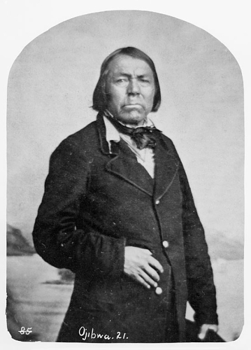
Naagaanab, a contemporary of Maangozid (Undated, Newberry Library Chicago)
In fairness to Maangozid, he was recognized as a skilled speaker and a leader in the Midewiwin religion. His father was a famous chief at Sandy Lake, but his brothers inherited that role. He married into the family of Zhingob (Shingoop, “Balsam”) a chief at Fond du Lac, and served as his speaker. Zhingob was part of the Marten clan, which had produced many of Fond du Lac’s chiefs over the years (many of whom were called Zhingob or Zhingobiins). Maangozid, a member of the Loon clan born in Sandy Lake, was seen as something of an outsider. After Zhingob’s death in 1835, Maangozid continued to speak for the Fond du Lac band, and many whites assumed he was the chief. However, it was younger men of the Marten clan, Nindibens (who went by his father’s name Zhingob) and Naagaanab, who the people recognized as the leaders of the band.
Certainly some of Maangozid’s ubiquity comes from his role as the outward voice of the Fond du Lac band, but there seems to be more to it than that. He just seems to be one of those people who through cleverness, ambition, and personal charisma, had a knack for always being where the action was. In the bestselling book, The Tipping Point, Malcolm Gladwell talks all about these types of remarkable people, and identifies Paul Revere as the person who filled this role in 1770s Massachusetts. He knew everyone, accumulated information, and had powers of persuasion. We all know people like this. Even in the writings of uptight government officials and missionaries, Maangozid comes across as friendly, hilarious, and most of all, everywhere.
Recently, I read The Ojibwe Journals of Edmund F. Ely 1833-1849 (U. of Nebraska Press; 2012), edited by Theresa Schenck. There is a great string of journal entries spanning from the Fall of 1836 to the summer of 1837. Maangozid, feeling unappreciated by the other members of the band after losing out to Nindibens in his bid for leadership after the death of Zhingob, declares he’s decided to become a Christian. Over the winter, Maangozid visits Ely regularly, assuring the stern and zealous missionary that he has turned his back on the Midewiwin. The two men have multiple fascinating conversations about Ojibwe and Christian theology, and Ely rejoices in the coming conversion. Despite assurances from other Ojibwe that Maangozid has not abandoned the Midewiwin, and cold treatment from Maangozid’s wife, Ely continues to believe he has a convert. Several times, the missionary finds him participating in the Midewiwin, but Maangozid always assures Ely that he is really a Christian.

J.G. Kohl (Wikimedia Commons)
It’s hard not to laugh as Ely goes through these intense internal crises over Maangozid’s salvation when its clear the spurned chief has other motives for learning about the faith. In the end, Maangozid tells Ely that he realizes the people still love him, and he resumes his position as Mide leader. This is just one example of Maangozid’s personality coming through the pages.
If you’re scanning through some historical writings, and you see his name, stop and read because it’s bound to be something good. If you find a time machine that can drop us off in 1850, go ahead and talk to Chief Buffalo, Madeline Cadotte, Hole in the Day, or William Warren. The first person I’d want to meet would be Maangozid. Chances are, he’d already be there waiting.
Anyway, I promised a family tree and here it is. These pages come from Kitchi-Gami: wanderings round Lake Superior (1860) by Johann Georg Kohl. Kohl was a German adventure writer who met Maangozid at La Pointe in 1855.
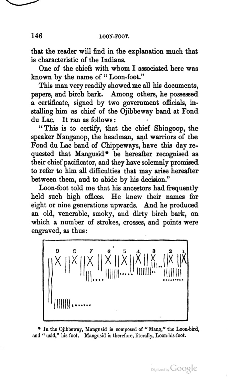
When Kitchi-Gami was translated from German into English, the original French in the book was left intact. Being an uncultured hillbilly of an American, I know very little French. Here are my efforts at translating using my limited knowledge of Ojibwe, French-Spanish cognates, and Google Translate. I make no guarantees about the accuracy of these translations. Please comment and correct them if you can.
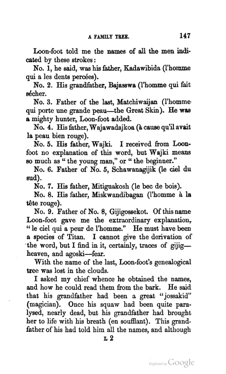
1) This one is easy. This is Gaadawaabide, Maangozid’s father, a famous Sandy Lake chief well known to history. Google says “the one with pierced teeth.” The Ojibwe People’s Dictionary translates it as “he had a gap in his teeth.” Most 19th-century sources call him Broken Tooth, La Breche, or Katawabida (or variants thereof).
2) Also easy–this is the younger Bayaaswaa, the boy whose father traded his life for his when he was kidnapped by the Meskwaki (Fox) (see post from March 30, 2013). Bayaaswaa grew to be a famous chief at Sandy Lake who was instrumental in the 18th-century Ojibwe expansion into Minnesota. Google says “the man who makes dry.” The Ojibwe People’s Dictionary lists bayaaswaad as a word for the animate transitive verb “dry.”
3) Presumably, this mighty hunter was the man Warren called Bi-aus-wah (Bayaaswaa) the Father in History of the Ojibways. That isn’t his name here, but it was very common for Anishinaabe people to have more than one name. It says “Great Skin” right on there. Google has the French at “the man who carries a large skin.” Michiiwayaan is “big animal skin” according to the OPD.
4) Google says “because he had very red skin” for the French. I don’t know how to translate the Ojibwe or how to write it in the modern double-vowel system.
5) Weshki is a form of oshki (new, young, fresh). This is a common name for firstborn sons of prominent leaders. Weshki was the name of Waabojiig’s (White Fisher) son, and Chief Buffalo was often called in Ojibwe Gichi-weshki, which Schoolcraft translated as “The Great Firstborn.”
6) “The Southern Sky” in both languages. Zhaawano-giizhig is the modern spelling. For an fascinating story of another Anishinaabe man, named Zhaawano-giizhigo-gaawbaw (“he stands in the southern sky”), also known as Jack Fiddler, read Killing the Shamen by Thomas Fiddler and James R. Stevens. Jack Fiddler (d.1907), was a great Oji-Cree (Severn Ojibway) chief from the headwaters of the Severn River in northern Ontario. His band was one of the last truly uncolonized Indian nations in North America. He commited suicide in RCMP custody after he was arrested for killing a member of his band who had gone windigo.
7) Google says, “the timber sprout.” Mitig is tree or stick. Something along the lines of sprouting from earth makes sense with “akosh,” but my Ojibwe isn’t good enough to combine them correctly in the modern spelling. Let me know if you can.
8) Google just says, “man red head.” Red Head is clearly the Ojibwe meaning also–miskondibe (OPD).
9) “The Sky is Afraid of the Man”–I can’t figure out how to write this in the modern Ojibwe, but this has to be one of the coolest names anyone has ever had.
**UPDATE** 5/14/13
Thank you Charles Lippert for sending me the following clarifications:
“Kadawibida Gaa-dawaabide Cracked Tooth
Bajasswa Bayaaswaa Dry-one
Matchiwaijan Mechiwayaan Great Hide
Wajki Weshki Youth
Schawanagijik Zhaawano-giizhig Southern Skies
Mitiguakosh Mitigwaakoonzh Wooden beak
Miskwandibagan Miskwandibegan Red Skull
Gijigossekot Giizhig-gosigwad The Sky Fears
“I am cluless on Wajawadajkoa. At first I though it might be a throat word (..gondashkwe) but this name does not contain a “gon”. Human skin usually have the suffix ..azhe, which might be reflected here as aja with a 3rd person prefix w.”

Kohl’s Kitchi-Gami is a very nice, accessible introduction to the culture of this area in the 1850s. It’s a little light on the names, dates, and events of the narrative political history that I like so much, but it goes into detail on things like houses, games, clothing, etc.
There is a lot to infer or analyze from these three pages. What do you think? Leave a comment, and look out for an upcoming post about Tagwagane, a La Pointe chief who challenges the belief that “the Loon totem [is] the eldest and noblest in the land.”
