Among The Otchipwees: I
May 28, 2016
By Amorin Mello

Magazine of Western History Illustrated
No. 2 December 1884
as republished in
Magazine of Western History: Volume I, pages 86-91.
AMONG THE OTCHIPWEES.
Like all the northern tribes, the Chippewas are known by a variety of names. The early French called them Sauteus, meaning people of the Sault. Later missionaries and historians speak of them as Ojibways, or Odjibwes. By a corruption of this comes the Chippewa of the English.

“No-tin” copied from 1824 Charles Bird King original by Henry Inman in 1832-33. Noodin (Wind) was a prominent Chippewa chief from the St. Croix country.
~ Commons.Wikimedia.org
On the south of the Chippewas, in 1832, across the Straits of Mackinaw, were the Ottawas. Some of this nation were found by Champlain on the Ottawa River of Canada, whom he called Ottawawas. In later years there were some of them on Lake Superior, of whom it is probable the Lake Court Oreille band, in northwestern Wisconsin, is a remainder. The French call them “Court Oreillés,”, or short ears. All combined, it is not a powerful nation. Many of them pluck the hair from a large part of the scalp, leaving only a scalp lock. This custom they explain as a concession to their enemies, in order to make a more neat and rapid job of the scalping process. A thick head of coarse hair, they say, is a great impediment. Probably the true reason is a notion of theirs that a scalp lock is ornamental. The practice is not universal among Ottawas, and is not common with the neighboring tribes. These were the people who committed the massacre of the English garrison at Old Mackinaw, in 1763.
![Mah-kée-mee-teuv, Grizzly Bear, Chief of the [Menominee] Tribe by George Catlin, 1831. ~ Smithsonian Institute](https://chequamegonhistory.com/wp-content/uploads/2016/05/1831-mah-kee-mee-teuv-grizzly-bear-by-george-catlin.jpg)
“Mah-kée-mee-teuv, Grizzly Bear, Chief of the [Menominee] Tribe” by George Catlin, 1831.
~ Smithsonian Institute
The Oneidas, a small remnant of that nation, from New York, were located on Duck River, near Fort Howard, and the Tuscaroras on the south shore of Lake Winnebago.

Detail from “Among The Winnebago [Ho-Chunk] Indians. Wah-con-ja-z-gah (Yellow Thunder) Warrior chief 120 y’s old” stereograph by Henry Hamilton Bennett, circa 1870s.
~ J. Paul Getty Museum
Plaster life cast of Sac leader Black Hawk (Makatai Meshe Kiakiak) reproduced by Bill Whittaker (original was made circa 1830) on display at Black Hawk State Historic Site.
~ Wikipedia.org
Next to the Menominees on the west were the Winnebagoes, a barbarous, warlike and treacherous people, even for Indians. Their northern border joined the Chippewas. Yellow Thunder’s village, in 1832, was on the trail from Lake Winnebago to Fort Winnebago, south of the Fox River about half way. He was more of a prophet, medicine man or priest, than warrior. In the Black Hawk war man of the Winnebago bucks joined the Sacs and the Foxes. Only four years before the United States was obliged to send an expedition against them, and to build a stockade at the portage. Their chiefs, old men, and medicine men, professed to be very friendly to us, but kept up constant communications with Black Hawk. When he was beaten at the Bad Ax River, and his warriors dispersed, they followed the old chief into the northern forest, captured him, and delivered him to the United States forces.
One of the causes of the Black Hawk War in 1832 was the murder of a party of Menominees near Fort Crawford, by the Sacs and Foxes. There was an ancient feud between those tribes which implies a series of scalping parties from generation to generation.

Sac leader “Ke-o-kuk or the Watchful Fox” by Thomas M. Easterly, 1847.
~ Missouri History Museum
As the Menominees were at peace with the United States, and their camps were near the garrison, they were considered to have been under Federal protection, and their murder as an insult to its authority. The return of Keokuk’s band to the Rock River country brought on a crisis in the month of May. The Menominees were anxious to avenge themselves, but were quieted by the promise of the government that the Sacs and Foxes should be punished. They offered to accompany our troops as scouts or spies, which was not accepted until the month of July, when Black Hawk had returned to the Four Lakes, where is now the city of Madison.
On a bright afternoon, about the middle of the month, a company of Menominee warriors emerged in single file from the woods in rear of Fort Howard at the head of Green Bay. They numbered about seventy-five, each one with a gun in his right hand, a blanket over his right shoulder, held across the breast by the naked left arm, and a tomahawk. Around the waist was a belt, on which was a pouch and a sheath, with a scalping knife. Their step was high and elastic, according to the custom of the men of the woods. On their faces was an excess of black paint, made more hideous by streaks of red. Their coarse black hair was decorated with all the ribbons and feathers at their command. Some wore moccasins and leggings of deer skin, but a majority were barefooted and barelegged. They passed across the common to the ferry, where they were crossed to Navarino, and marched to the Indian Agency at Shantytown. Here they made booths of the branches of trees. Captain or Colonel Hamilton, a son of Alexander Hamilton, was their commander. As they had an abundance to eat and were filled with martial prowess, they were exceedingly jubilant.
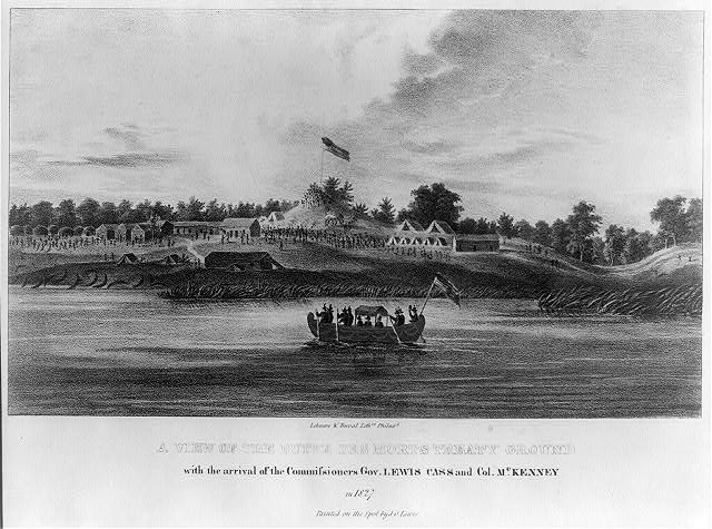
“A view of the Butte des Morts treaty ground with the arrival of the commissioners Gov. Lewis Cass and Col. McKenney in 1827” by James Otto Lewis, 1835.
~ Library of Congress
Their march was up the valley of the river, recrossing above Des Peres, passing the great Kakolin, and the Big Butte des Morts to the present site of Oshkosh. Thence crossing again they followed the trail to the Winnebago villages, past the Apukwa or Rice lakes to Fort Winnebago, making about twenty miles a day. On the route they were inclined to straggle, presenting nothing of military aspect except a uniform of dirty blankets. Colonel Hamilton was not able to make them stand guard, or to send out regular pickets. They were expert scouts in the day time, but at night lay down to sleep in security, trusting to their dogs, their keen sense of hearing and the great spirit. On the approach of day they were on the alert. It is a rule in Indian tactics to operate by surprises, and to attack at the first show of light in the morning.
From Fort Winnebago they moved to the Four Lakes, where Madison now is. Black Hawk had retired across the Wisconsin River, where there was a skirmish on the 21st of July, and the battle of the Bad Ax was being fought.

Photograph of Pierre Jean Édouard Desor (Swiss geologist and professor at Neuchâtel academy) from Wisconsin Historical Society. Desor and others were employed to survey for Report on the geology and topography of a portion of the Lake Superior Land District in the state of Michigan: Part I, Copper Lands; Part II, The Iron Region.
A few miles southwesterly of Waukedah, on the branch railroad to the iron mines of the upper Menominee, is a lake called by the Indians “Shope,” or Shoulder Lake, which I visited in the fall of 1850, in company with the late Edward Desor, a scientist of reputation in Switzerland. It discharges into the Sturgeon River, one of the eastern branches of the Menominee. There was a collection of half a dozen lodges, or wigwams, covered with bark, with a small field of corn, and the usual filth of an Indian village. The patriarch, or “chief” of that clan, came out to meet us, attended by about thirty men, women and children. By the traders he was called “Governor.” His nose was prominently Roman. He stood evenly on both feet, with his limbs bare below the knees. The right arm was also bare, and over the left shoulder was thrown a dirty blanket, covering the chest and the hips. A mass of coarse black hair covered the head, but was pushed away from the face. The usual dark, steady, snakelike, black eye of the race examined us with a piercing gaze. His face, with its large, well proportioned features, was almost grand. his pose was easy, unstudied and dignified, like one’s ideal of the Roman patrician of the time of Cicero, such as sculptors would select as a model.
This band were the Chippewas, but the coast of Green Bay was occupied by Menominees or Menomins, known to the French as “Folle Avoines,” or “Wild Rice” Indians, for which Menomin is the native name. Above the Twin Falls of the Menominee was an ancient village of Chippewas, called the “Bad Water” band, which is their name for a series of charming lakes not far distant, on the west of the river. They said their squaws, a long time since, were on the lakes in a bark canoe. Those on the land saw the canoe stand up on end, and disappear beneath the surface with all who were in it. “Very bad water.” From that time they were called the “Bad Water” lakes.

The Bad Water Band of Lake Superior Chippewa was first documented by Captain Thomas Jefferson Cram in his 1840 report to Congress.
~ Dickinson County Library
Cavalier was a half-breed French and Menominee. He was a handsome young man, and was well aware of it. Though he was married, the squaws received his attentions without much reserve. Half-breeds dress like the whites of the trading post, and not as Indians. Their hair is cut, and instead of a blanket they have coarse overcoats, and wear hats. Many of them are traders, a class mid-way between the whites and Indians.

No Princess Zone: Hanging Cloud, the Ogichidaakwe is a popular feature here on Chequamegon History.
Polygamy is the most fixed of savage institutions, and one that the half-breed and trader does not despise. Chippewa maidens, and even wives, have many reasons for looking kindly upon men who wear citizens’ clothes and trade in finery. Moccasins they can make very beautifully, but shawls and strouds of broadcloth, silk ribbons, pewter broaches, brass rings, and glass beads they cannot. These are the work of the white man. But none of that race, man or maid, has a more powerful passion for the ornamental than the children of the forest, male or female. Let us not judge the latter too harshly – poor, ignorant, suffering slave, with none of the protection which the African slave could sometimes invoke against barbarian cruelty. Their children are as happy and playful as those of the white race. Before they become men and women they are frequently beautiful, the deep brunette of their complexion having, on the cheek, a faint tinge of a lighter color, especially among those from the far north, like the “Bois Forts” of Rainy Lake. Young lads and girls have well formed limbs and straight figures, with agile and graceful movements. At this age the burdens and hardships of the squaws have not deformed them. The smoke of the lodge has not tanned their skin to Arab-like blackness nor inflamed their eyes. In about ten years of drudgery, rowing the canoe, putting up lodges, bearing children, and not infrequent beatings by her lord, the squaw is an old woman. Her features become rough and angular, the melodious voice of childhood is changed to one that is sharp, shrill, piercing and disagreeable. At forty she is a decrepit old woman, and before that time, if her master has not put her away, he may have installed number two as an additional tyrant.
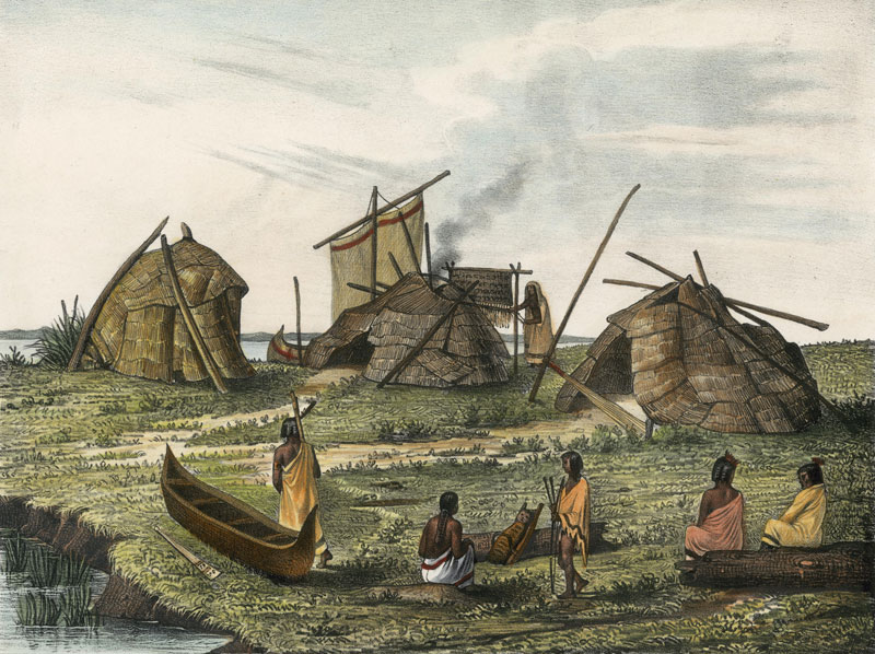
A Menominee village in “Village of Folle-Avoines” by Francis de Laporte de Castelnau, 1842.
~ Wisconsin Historical Society
Well up the Peshtigo, on a rainy, foggy afternoon, we made an early camp near a dismal swamp on the low ground. On the other side of the river, at a considerable distance, was heard the moans of a person evidently in great distress. Cavalier was sent over to investigate. He found a wigwam with a Menominee and two women, both wives. The youngest was on a bridal tour. The old wife had broken her thigh about a month before, which had not been set. She was suffering intensely, the limb very much swollen, and the bridal party wholly neglecting her. It was evident that death was her only relief. A strong dose of morphine gradually moderated her groans, which were more pathetic than anything that ever reached my ears. Before morning she was quiet.
As the water was very low I went through the gorge of the Menominee above the Great Bekuennesec, or Smoky Falls. Near the lower end, and in hearing of the cataract, I saw through the rocky chasm a mountain in the distance to the northeast. My half-breed said the Indians called it Thunder Mountain. They say that thunder is caused by an immense bird which goes there, when it is enveloped by clouds and flaps its wings furiously.
Turning away from the mists of the cataract and its never ceasing roar, we went southwesterly among the pines, over rocks and through swamps, to a time worm trail leading from the Bad Water village to the Pemenee Falls. This had been for many years the land route from Kewenaw Bay to the waters of Green Bay at the mouth of the Menominee River. When the copper mines on Point Kewenaw were opened, in 1844 and 1845, the winter mail was carried over this route on dog trains, or on the backs of men. Deer were very plenty in the Menominee valley. Bands of Pottawatomies scoured the woods, killing them by hundreds for their skins. We did not kill them until near the close of the day, when about to encamp. Cavalier went forward along the trail to make camp and shoot a deer. I heard the report of his gun, and expected the usual feast of fresh venison. “Where is your deer?” “Don’t know; some one has put a spell on my gun, and I believe I know who did it.”
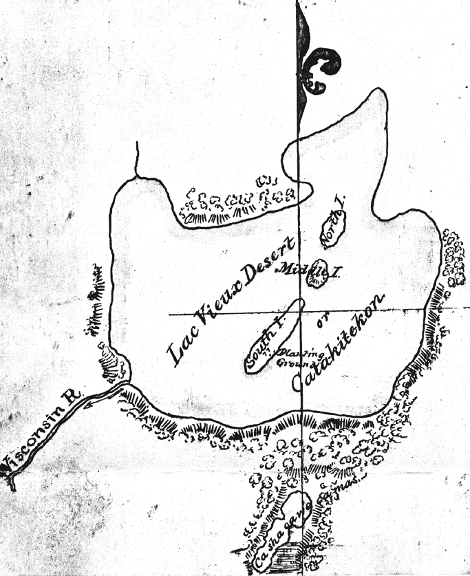
Map of Lac Vieux Desert with “Catakitekon” [Gete-gitigaan (old gardens)] from Thomas Jefferson Cram’s 1840 fieldbook.
~ School District of Marshfield: Digital Time Travelers
The Chippewas are spread over the shores and the rivers of Lake Superior, Lake Nipigon, the heads of the Mississippi, the waters of Red Lake, Rainy Lake and the tributaries of the Lake of the Woods. When Du Lhut and Hennepin first became acquainted with the tribes in that region, the Sioux, Dacotas, or Nadowessioux, and the Chippewas were at war, as they have been ever since. The Sioux of the woods were located on the Rum, or Spirit River, and their warriors had defeated the Chippewas at the west end of Lake Superior. Hennepin was a prisoner with a band of Sioux on Mille Lac, in 1680, at the head of Rum River, called Isatis. When Johnathan Carver was on the upper Mississippi, in 1769, the Chippewas had nearly cleared the country between there and Lake Superior of their enemies. In 1848 their war parties were still making raids on the Sioux and the Sioux upon them.
CHARLES WHITTLESEY.
To be continued in Among The Otchipwees: II…
This post is on of several that seeks to determine how many images exist of Great Buffalo, the famous La Pointe Ojibwe chief who died in 1855. To learn why this is necessary, read this post introducing the Great Chief Buffalo Picture Search.
Today’s post looks at two paintings from the 1820s of Ojibwe men named Bizhiki (Buffalo). The originals are lost forever, but the images still exist in the lithographs that follow.

Pee-che-kir: A Chippewa Chief Lithograph from McKenney and Hall’s History of the Indian Tribes of North America based on destroyed original by Charles Bird King; 1824. (Wikimedia Images)

Pe-shick-ee: A Celebrated Chippeway Chief from the Aboriginal Port-Folio by James Otto Lewis. The original painting was done by Lewis at Prairie du Chien or Fond du Lac of Lake Superior in 1825 or 1826 (Wisconsin Historical Society).
1824 Delegation to Washington
Chronologically, the first known image to show an Ojibwe chief named Buffalo appeared in the mid-1820s at time when the Ojibwe and the United States government were still getting to know each other. Prior to the 1820s, the Americans viewed the Ojibwe as a large and powerful nation. They had an uncomfortably close history with the British, who were till lurking over the border in Canada, but they otherwise inhabited a remote country unfit for white settlement. To the Ojibwe, the Americans were chimookomaan, “long knives,” in reference to the swords carried by the military officers who were the first Americans to come into their country. It was one of these long knives, Thomas McKenney, who set in motion the gathering of hundreds of paintings of Indians. Two of these showed men named Buffalo (Bizhiki).

Charles Bird King: Self portrait 1815 (Wikimedia Images)
McKenney was appointed the first Superintendent of Indian Affairs in 1824. Indian Affairs was under the Department of War at that time, and McKenneyʼs men in the West were mostly soldiers. He, like many in his day, believed that the Indian nations of North America were destined for extinction within a matter of decades. To preserve a record of these peoples, he commissioned over 100 portraits of various Indian delegates who came to Washington from all over the U.S. states and territories. Most of the painting work fell to Charles Bird King, a skilled Washington portrait artist. Beginning in 1822, King painted Indian portraits for two decades. He would paint famous men like Black Hawk, Red Jacket, Joseph Brandt, and Major Ridge, but Kingʼs primary goal was not to record the stories of important individuals so much as it was to capture the look of a vanishing race.

No-tin copied from 1824 Charles Bird King original by Henry Inman. Noodin (Wind) was a prominent chief from the St. Croix country. King’s painting of Buffalo from St. Croix was probably also copied by Inman, but its location is unknown (Wikimedia Images).
In July of 1824, William Clark, the famous companion of Meriwether Lewis, brought a delegation of Sauks, Foxes, and Ioways to Washington to negotiate land cessions. Lawrence Taliaferro, the Indian agent at Fort St. Anthony (now Minneapolis), brought representatives of the Sioux, Menominee, and Ojibwe to observe the treaty process. The St. Croix chiefs Buffalo and Noodin (Wind) represented the Ojibwe.

Charles Bird King painted portraits of most of the Indians listed here in the the 1824 Washington group by Niles’ Weekly Register, July 31, 1824. (Google Books)
The St. Croix chiefs were treated well: taken to shows, and to visit the sights of the eastern cities. However, there was a more sinister motivation behind the governmentʼs actions. McKenney made sure the chiefs saw the size and scope of the U.S. Military facilities in Washington, the unspoken message being that resistance to American expansion was impossible. This message seems to have resonated with Buffalo and Noodin of St. Croix as it is referred to repeatedly in the official record. McKenney pointed Buffalo out as a witness to American power at the Treaty of Fond du Lac (1826). Schoolcraft and Allen mention Buffalo’s trip in their own ill-fated journey up the St. Croix in 1832 (see it in this post), and Noodin talks about the soldiers he saw in Washington in the treaty deliberations in the 1837 Treaty of St. Peters.
While in Washington, Buffalo, Noodin, and most of the other Indians in the group sat with King for portraits in oil. Buffalo was shown wearing a white shirt and cloak, holding a pipe, with his face painted red. The paintings were hung in the offices of the Department of War, and the chiefs returned to their villages.
James Otto Lewis
The following summer, St. Croix Buffalo and Noodin joined chiefs from villages throughout the Ojibwe country, as well as from the Sioux, Sac and Fox, Menominee, Ho-Chunk, Ioway, Ottawa, and Potawatomi at Prairie du Chien. The Americans had called them there to sign a treaty to establish firm borders between their nations. The stated goal was to end the wars between the Sioux and Ojibwe, but it also provided the government an opportunity to assert its authority over the country and to set the stage for future land cessions.
McKenney did not attend the Treaty of Prairie du Chien leaving it to Clark and Lewis Cass to act as commissioners. A quick scan of the Ojibwe signatories shows “Pee-see- ker or buffalo, St. Croix Band,” toward the bottom. Looking up to the third signature, we see “Gitspee Waskee, or le boeuf of la pointe lake Superior,” so both the St. Croix and La Pointe Buffalos were present among the dozens of signatures. One of the government witnesses listed was an artist from Philadelphia named James Otto Lewis. Over the several days of negotiation, Lewis painted scenes of the treaty grounds as well as portraits of various chiefs. These were sent back to Washington, some were copied and improved by King or other artists, and they were added to the collection of the War Department.
The following year, 1826, McKenney himself traveled to Fond du Lac at the western end of Lake Superior to make a new treaty with the Ojibwe concerning mineral exploration on the south shore. Lewis accompanied him and continued to create images. At some point in these two years, a Lewis portrait of an Ojibwe chief named Pe-schick-ee (Bizhiki) appeared in McKenneyʼs growing War Department collection.
Lithographs
By 1830, McKenney had been dismissed from his position and turned his attention to publishing a portfolio of lithographs from the paintings in the War Department collection. Hoping to cash in his own paintings by beating McKenney to the lithograph market, Lewis released The Aboriginal Port Folio in May of 1835. It included 72 color plates, one of which was Pe-schick-ee: A Celebrated Chippeway Chief.

Pencil sketch of Pee-che-kir by Charles Bird King. King made these sketches after his original paintings to assist in making copies. (Herman J. Viola, The Indian Legacy of Charles Bird King.)
Due to financial issues The History of the Indian Tribes of North America, by McKenney with James Hall, would not come out in full release until the mid 1840s. The three-volume work became a bestseller and included color plates of 120 Indians, 95 of which are accompanied by short biographies. Most of the lithographs were derived from works by King, but some were from Lewis and other artists. Kingʼs portrait of Pee-Che-Kir: A Chippewa Chief was included among them, unfortunately without a biography. However, we know its source as the painting of the St. Croix Buffalo in 1824. Noodin and several others from that delegation also made it into lithograph form. The original War Department paintings, including both Pee-Che-Kir and Pe-schick-ee were sent to the Smithsonian, where they were destroyed in a fire in 1858. Oil copies of some of the originals, including Henry Inmanʼs copy of Kingʼs portrait of Noodin, survive, but the lithographs remain the only known versions of the Buffalo portraits other than a pencil sketch of the head of Pee-Che-Kir done by King.
The man in the Lewis lithograph is difficult to identify. The only potential clue we get from the image itself is the title of “A Celebrated Chippeway Chief,” and information that it was painted at Prairie du Chien in 1825. To many, “celebrated” would indicate Buffalo from La Pointe, but in 1825, he was largely unknown to the Americans while the St. Croix Buffalo had been to Washington. In the 1820s, La Pointe Buffaloʼs stature was nowhere near what it would become. However, he was a noted speaker from a prominent family and his signature is featured prominently in the treaty. Any assumptions about which chief was more “celebrated” are difficult.
In dress and pose, the man painted by Lewis resembles the King portrait of St. Croix Buffalo. This has caused some to claim that the Lewis is simply the original version of the King. King did copy and improve several of Lewisʼ works, but the copies tended to preserve in some degree the grotesque, almost cartoonish, facial features that are characteristic of the self-taught Lewis (see this post for another Lewis portrait). The classically-trained King painted highly realistic faces, and side-by-side comparison of the lithographs shows very little facial resemblance between Kingʼs Pee-Che-Kir and Lewisʼ Pe-schick-ee.

Thomas L. McKenney painted in 1856 by Charles Loring Elliott (Wikimedia Images)
Of the 147 War Department Indian portraits cataloged by William J. Rhees of the Smithsonian prior to the fire, 26 are described as being painted by “King from Lewis,” all of which are from 1826 or after. Most of the rest are attributed solely to King. Almost all the members of the 1824 trip to Washington are represented in the catalog. “Pee-che-ker, Buffalo, Chief of the Chippeways.” does not have an artist listed, but Noodin and several of the others from the 1824 group are listed as King, and it is safe to assume Buffalo’s should be as well. The published lithograph of Pee-che-kir was attributed solely to King, and not “King from Lewis” as others are. This further suggests that the two Buffalo lithographs are separate portraits from separate sittings, and potentially of separate chiefs.
Even without all this evidence, we can be confident that the King is not a copy of the Lewis because the King portrait was painted in 1824, and the Lewis was painted no earlier than 1825. There is, however, some debate about when the Lewis was painted. From the historical record, we know that Lewis was present at both Prairie du Chien and Fond du Lac along with both the La Pointe Buffalo and the St. Croix Buffalo. When Pe- schick-ee was released, Lewis identified it as being painted at Prairie du Chien. However, the work has also been placed at Fond du Lac.
The modern identification of Pee-che-kir as a copy of Pe-schick-ee seems to have originated with the work of James D. Horan. In his 1972 book, The McKenney-Hall Portrait Gallery of American Indians, he reproduces all the images from History of the Indian Tribes, and adds his own analysis. On page 206, he describes the King portrait of Pee-che-kir with:
“Peechekir (or Peechekor, Buffalo) was “a solid, straight formed Indian,” Colonel McKenney recalled many years after the Fond du Lac treaty where he had met the chief. Apparently the Chippewa played a minor role at the council.
Original by James Otto Lewis, Fond du Lac council, 1826, later copied in Washington by Charles Bird King.”
Presumably, the original he refers to would be the Lewis portrait of Pe-schick-ee. However, Horanʼs statement that McKenney met St. Croix Buffalo at Fond du Lac is false. As we already know, the two men met in 1824 in Washington. It is puzzling how Horan did not know this considering he includes the following account on page 68:
The first Indian to step out of the closely packed lines of stone-faced red men made McKenney feel at home; it was a chief he had met a few years before in Washington. The Indian held up his hand in a sign of peace and called out:
“Washigton [sic]… Washington… McKenney shook hands with the chief and nodded to Lewis but the artist had already started to sketch.”
McKenneyʼs original account identifies this chief as none other than St. Croix Buffalo:
In half an hour after, another band came in who commenced, as did the others, by shaking hands, followed, of course, by smoking. In this second band I recognized Pee-che-kee, or rather he recognized me–a chief who had been at Washington, and whose likeness hangs in my office there. I noticed that his eye was upon me, and that he smiled, and was busily employed speaking to an Indian who sat beside him, and no doubt about me. His first word on coming up to speak to me was, “Washington”–pointing to the east. The substance of his address was, that he was glad to see me–he felt his heart jump when he first saw me–it made him think of Washington, of his great father, of the good living he had when he visited us–how kind we all were to him, and that he should never forget any of it.
From this, Horan should have known not only that the two men knew each other, but also that a portrait of the chief (Kingʼs) already was part of the War Department collection and therefore existed before the Lewis portrait. Horanʼs description of Lewis already beginning his sketch does not appear in McKenneyʼs account and seems to invented. This is not the only instance where Horan confuses facts or takes wide license with Ojibwe history. His statement quoted above that the Ojibwe “played a minor role” in the Treaty of Fond du Lac, when they were the only Indian nation present and greatly outnumbered the Americans, should disqualify Horan from being treated as any kind of authority on the topic. However, he is not the only one to place the Lewis portrait of Pe-schick-ee at Fond du Lac rather than Prairie du Chien.
Between, 1835 and 1838 Lewis released 80 lithographs, mostly of individual Indians, in a set of ten installments. He had intended to include an eleventh with biographies. However, a dispute with the publisher prevented the final installment from coming out immediately. His London edition, released in 1844 by another publisher, included a few short biographies but none for Pe-schick-ee. Most scholars assumed that he never released the promised eleventh installment. However, one copy of a self-published 1850 pamphlet donated by Lewisʼs grandson exists in the Free Library of Philadelphia. In it are the remaining biographies. Number 30 reads:
No. 30. Pe-shisk-Kee. A Chippewa warrior from Lake Huron, noted for his attachment to the British, with whom he always sided. At the treaty held at Fond du Lac, when the Council opened, he appeared with a British medal of George the III. on his breast, and carrying a British flag, which Gen. Cass, one of the Commissioners, promptly and indignantly placed under his feet, and pointing to the stars and stripes, floating above them, informed him that that was the only one permitted to wave there.
The Chief haughtily refused to participate in the business of the Council, until, by gifts, he became partly conciliated, when he joined in their deliberations. Painted at Fond du Lac, in 1826.
This new evidence further clouds the story. Initially, this description does not seem to fit what we know about either the La Pointe or the St. Croix Buffalo, as both were born near Lake Superior and lived in Wisconsin. Both men were also inclined to be friendly toward the American government. The St. Croix Buffalo had recently been to Washington, and the La Pointe Buffalo frequently spoke of his desire for good relations with the United States in later years. It is also troubling that Lewis contradicts his earlier identification of the location of the portrait at Prairie du Chien.
It is unlikely that Pe-schick-ee depicts a third chief given that no men named Buffalo other than the two mentioned signed the Treaty of Fond du Lac, and the far-eastern bands of Ojibwe from Lake Huron were not part of treaty councils with the Lake Superior bands. One can speculate that perhaps Lewis, writing 25 years after the original painting, mistook the story of Pe-schick-ee with that one of the many other chiefs he met in his travels, but there are some suggestions that it might, in fact, be La Pointe Buffalo.
The La Pointe Band traded with the British in the other side of Lake Superior for years after the War of 1812 supposedly confirmed Chequamegon as American territory. If you’ve read this post, you’ll know that Buffalo from La Pointe was a follower of Tenskwatawa, whose brother Tecumseh fought beside the British. On July 22, 1822, Schoolcraft writes:
At that place [Chequamegon] lived, in comparatively modern times, Wabojeeg and Andaigweos, and there still lives one of their descendants in Gitchee Waishkee, the Great First-born, or, as he is familiarly called, Pezhickee, or the Buffalo, a chief decorated with British insignia. His band is estimated at one hundred and eighteen souls, of whom thirty-four are adult males, forty-one females, and forty-three children.
It’s possible that it was La Pointe Buffalo with the British flag. Archival research into the Treaty of Fond du Lac could potentially clear this up. If I stumble across any, I’ll be sure to add it here. For now, we can’t say one way or the other which Buffalo is in the Lewis portrait.
The Verdict
Not Chief Buffalo from La Pointe: This is Chief Buffalo from St. Croix.
Inconclusive: This could be Buffalo from La Pointe or Buffalo from St. Croix.
Sources:
Horan, James David, and Thomas Loraine McKenney. The McKenney-Hall Portrait Gallery of American Indians. New York, NY: Bramhall House, 1986. Print.
KAPPLER’S INDIAN AFFAIRS: LAWS AND TREATIES. Ed. Charles J. Kappler. Oklahoma State University Library, n.d. Web. 21 June 2012. <http:// digital.library.okstate.edu/Kappler/>.
Lewis, James O., The Aboriginal Port-Folio: A Collection of Portraits of the Most Celebrated Chiefs of the North American Indians. Philadelphia: J.O. Lewis, 1835-1838. Print.
———– Catalogue of the Indian Gallery,. New York: J.O. Lewis, 1850. Print.
Loew, Patty. Indian Nations of Wisconsin: Histories of Endurance and Renewal.
Madison: Wisconsin Historical Society, 2001. Print.
McKenney, Thomas Loraine. Sketches of a Tour to the Lakes of the Character and Customs of the Chippeway Indians, and of Incidents Connected with the Treaty of Fond Du Lac. Baltimore: F. Lucas, Jun’r., 1827. Print.
McKenney, Thomas Loraine, and James Hall. Biographical Sketches and Anecdotes of Ninety-five of 120 Principal Chiefs from the Indian Tribes of North America. Washington: U.S. Dept. of the Interior, Bureau of Indian Affairs, 1967. Print.
Moore, Robert J. Native Americans: A Portrait : The Art and Travels of Charles Bird King, George Catlin, and Karl Bodmer. New York: Stewart, Tabori & Chang, 1997. Print.
Niles, Hezekiah, William O. Niles, Jeremiah Hughes, and George Beatty, eds. “Indians.” Niles’ Weekly Register [Baltimore] 31 July 1824, Miscellaneous sec.: 363. Print.
Rhees, William J. An Account of the Smithsonian Institution. Washington: T. McGill, 1859. Print.
Satz, Ronald N. Chippewa Treaty Rights: The Reserved Rights of Wisconsin’s Chippewa Indians in Historical Perspective. Madison, WI: Wisconsin Academy of Sciences, Arts and Letters, 1991. Print.
Schoolcraft, Henry Rowe, and Philip P. Mason. Expedition to Lake Itasca; the Discovery of the Source of the Mississippi,. [East Lansing]: Michigan State UP, 1958. Print.
Schoolcraft, Henry R. Personal Memoirs of a Residence of Thirty Years with the Indian Tribes on the American Frontiers: With Brief Notices of Passing Events, Facts, and Opinions, A.D. 1812 to A.D. 1842. Philadelphia: Lippincott, Grambo and, 1851. Print.
Viola, Herman J. The Indian Legacy of Charles Bird King. Washington: Smithsonian Institution, 1976. Print.
Warren, William W., and Theresa M. Schenck. History of the Ojibway People. St. Paul: Minnesota Historical Society, 2009. Print.
Special thanks to Theresa Schenck of the University of Wisconsin and Charles Lippert for helping me work through this information, and to Michael Edmonds of the Wisconsin Historical Society, and Alice Cornell (formerly of the University of Cincinnati) for tracking down the single copy of the unpublished James Otto Lewis catalog.
Note: This is the final post of four about Lt. James Allen, his ten American soldiers and their experiences on the St. Croix and Brule rivers. They were sent from Sault Ste. Marie to accompany the 1832 expedition of Indian Agent Henry Schoolcraft to the source of the Mississippi River. Each of the posts gives some general information about the expedition and some pages from Allen’s journal.

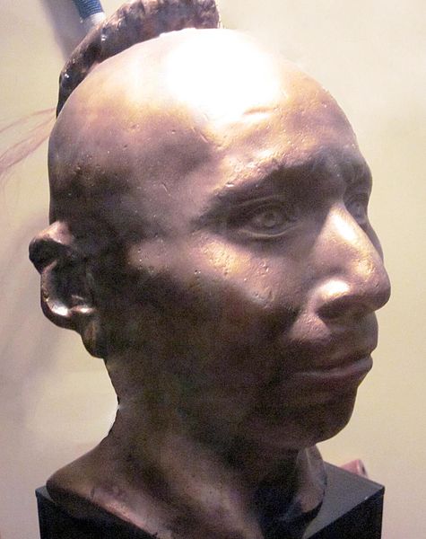
- Sauk Chief Makataimeshekiakiah, or Black Hawk by Charles Bird King (Wikimedia Images)

On the night of August 1, 1831, the section of the Michigan Territory that would become the state of Wisconsin, was a scene of stark contrasts regarding the United States Army’s ability to force its will on Indian people. In the south, American forces had caught up and skirmished with the starving followers of Black Hawk near the mouth of the Bad Axe River in present-day Vernon County. The next morning, with the backing of the steamboat Warrior, the soldiers would slaughter dozens of men, women, and children as they tried to retreat across the Mississippi. The massacre at Bad Axe was the end of the Black Hawk War, the last major military resistance from the Indian nations of the Old Northwest.
Less than 300 miles upstream, Lieutenant James Allen had his bread stolen right out of his fire as he slept. Presumably, it was taken by Ojibwe youths from the Yellow River village on the St. Croix. Earlier that day, he had been unable to get convince any members of the Yellow River band to guide him up to the Brule River portage. The next morning, (the same day as the Battle of Bad Axe), Allen was able to buy a new bark canoe to take some load off his leaky fleet. However, the Ojibwe family that sold it to him was able to take advantage of supply and demand to get twice the amount of flour from the soldiers that they would’ve gotten from the local traders. Later that day, the well-known chief Gaa-bimabi (Kabamappa), from the upper St. Croix, brought him a desperately-needed map, so not all of his interactions with the Ojibwe that day were negative. However, each of these encounters showed clearly that the Ojibwe were neither cowed nor intimidated by the presence of American soldiers in their country.
In fact, Allen’s detachment must have been a miserable sight. They had fallen several days behind the voyageur-paddled canoes carrying Schoolcraft, the interpreter, and the doctor. Their canoes were leaking badly and they were running out of gum (pitch) to seal them up. Their feet were torn up from wading up the rapids, and one man was too injured to walk. They were running low on food, didn’t know how to find the Brule, and their morale was running dangerously low. If the War Department’s plan was for Allen to demonstrate American power to the Ojibwe, the plan had completely backfired.
The journey down the Brule was even more difficult for the soldiers than the trip up the St. Croix. I won’t repeat it all here because it’s in the posted pages of Allen’s journal in these four posts, but in the end, it was our old buddy Maangozid (see 4/14/13 post) and some other Fond du Lac Ojibwe who rescued the soldiers from their ordeal.
Allen’s journal entry after finally reaching Lake Superior is telling:
“[T]he management of bark canoes, of any size, in rapid rivers, is an art which it takes years to acquire; and, in this country, it is only possessed by Canadians [mix-blooded voyageurs] and Indians, whose habits of life have taught them but little else. The common soldiers of the army have no experience of this kind, and consequently, are not generally competent to transport themselves in this way; and whenever it is required to transport troops, by means of bark canoes, two Canadian voyageurs ought to be assigned to each canoe, one in the bow, and another in the stern; it will then be the safest and most expeditious method that can be adopted in this country.”
The 1830s were the years of Indian Removal throughout the United States, but at that time, the American government had no hope of conquering and subduing the Ojibwe militarily. When the Ojibwe did surrender their lands (in 1837 and 1842 for the Wisconsin parts), it was due to internal politics and economics rather than any serious threat of American invasion. Rather than proving the strength of the United States, Allen’s expedition revealed a serious weakness.
The Ojibwe weren’t overconfident or ignorant. The very word for Americans, chimookomaan (long knife), referred to soldiers. A handful of Ojibwe and mix-blooded warriors had fought the United States in the War of 1812 and earlier in the Ohio country. Bizhiki and Noodin, two chiefs whose territory Allen passed through on his ill-fated journey, had been to Washington in 1824 and saw the army firsthand. The next year, many more chiefs got to see the long knives in person at the Treaty of Prairie du Chien. Finally, the removal of their Ottawa and Potawatomi cousins and other nations to Indian Territory in the 1830s was a well-known topic of concern in Ojibwe villages. They knew the danger posed by American soldiers, but the reality of the Lake Superior Country in 1832 was that American power was very limited.
The journal picks up from part 3 with Allen and crew on the Brule River with their canoes in rapidly-deteriorating condition. They’ve made contact with the Fond du Lac villagers camped at the mouth, but there are still several obstacles to overcome.
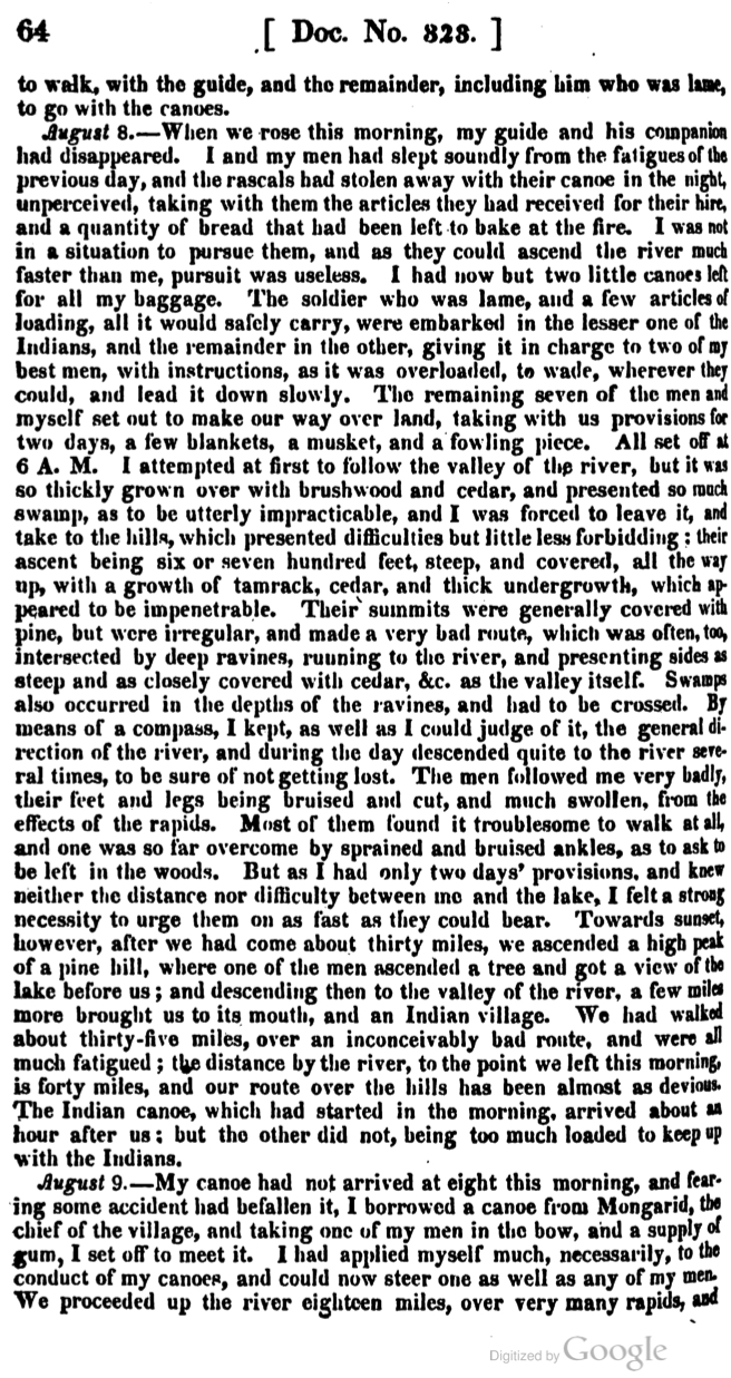
Doc. 323, pg. 66

Doc. 323, pg. 65

Doc. 323, pg. 66
Allen’s journal is part of Phillip P. Mason’s edition of Schoolcraft’s Expedition to Lake Itasca: The Discovery of the Source of the Mississippi (1958). However, these Google Books pages come from the original publication as part of the United States Congress Serial Set.

James Allen (1806-1846)
Collections of the Iowa Historical Society
Allen and all of his men survived the ordeal of the 1832 expedition. He returned to La Pointe on August 11 and left the next day with Dr. Houghton. The two men returned to the Soo together, stopping at the great copper rock on the Ontonagon River along the way.
On September 13, 1832, he wrote Alexander Macomb, his commander at Fort Brady. The letter officially complained about Schoolcraft “unnecessarily and injuriously” leaving the soldiers behind at the mouth of the St. Croix. When the New York American published its review of Schoolcraft’s Narrative on July 19, 1834, it expressed “indignation and dismay” at the “un-Christianlike” behavior of the agent for abandoning the soldiers in the “enemy’s country.” The resulting controversy forced Schoolcraft to defend himself in the Detroit Journal and Michigan Advertiser where he pointed out Allen’s map’s importance to the Narrative. He also reminded the public that the Ojibwe and the United States were considered allies.
James Allen went on to serve in Chicago and at the Sac and Fox agency in Iowa Territory. After the Mexican War broke out in 1846, he traveled to Utah and organized a Mormon Battalion to fight on the American side. He died on his way back east on August 23, 1846. He was only forty years old. (John Lindquist has great website about the career of James Allen with much more information about his post-1832 life).
Sources:
Ely, Edmund Franklin, and Theresa M. Schenck. The Ojibwe Journals of Edmund F. Ely, 1833-1849. Lincoln: University of Nebraska, 2012. Print.
Loew, Patty. Indian Nations of Wisconsin: Histories of Endurance and Renewal. Madison: Wisconsin Historical Society, 2001. Print.
Schoolcraft, Henry Rowe, and Philip P. Mason. Expedition to Lake Itasca; the Discovery of the Source of the Mississippi,. [East Lansing]: Michigan State UP, 1958. Print.
Warren, William W., and Theresa M. Schenck. History of the Ojibway People. St. Paul: Minnesota Historical Society, 2009. Print.
Witgen, Michael J. An Infinity of Nations: How the Native New World Shaped Early North America. Philadelphia: University of Pennsylvania, 2012. Print.
Note: This is the third of four posts about Lt. James Allen, his ten American soldiers and their experiences on the St. Croix and Brule rivers. They were sent from Sault Ste. Marie to accompany the 1832 expedition of Indian Agent Henry Schoolcraft to the source of the Mississippi River. Each of the posts will give some general information about the expedition and some pages from Allen’s journal.

Douglass Houghton (1809-1845) was the naturalist and physician for the expedition. While traveling with Schoolcraft’s lead group, he expressed frequent concern for Allen and the soldiers as they fell behind (painted by Alva Bradish, 1850; Wikimedia Commons).
Schoolcraft’s original book takes up the first quarter of the pages in the 1958 edition of Narrative of an Expedition, edited by Phillip P. Mason. The rest of the pages are six appendixes including the journals of Douglass Houghton the surgeon and geologist, W.T. Boutwell the missionary, and Allen. Of the four, Schoolcraft’s provides the blandest reading. His positive, official spin on everything offers little glimpse into his psyche. In contrast, Houghton gives us a unique account of smallpox vaccinations, botany, and geology. Boutwell gives us detailed descriptions of Ojibwe religious practices through his zealous missionary filter. His frequent complaints about mosquitoes, profane soldiers, Indian drumming, and voyageur gambling ruining his Sabbaths are very humorous to those who aren’t sympathetic to his mission.
Allen’s journal is fascinating. He was sent by the War Department to record information about the geography of the country and its people for military purposes. Officially the Ojibwe and the United States were friendly. Schoolcraft, being married into a prominent Ojibwe family at the Sault, promoted this idea. However, a sense of future military confrontation looms over the narrative. The Indian Removal Act was only two years old, and Black Hawk’s War broke out just as the expedition was starting out. In 1832, lasting peace between the Ojibwe and the United States was not automatically guaranteed.
The journal reads, at times, like a post-modern anti-colonial novel complete with Allen as the villainous narrator looking to get rich off Lake Superior copper and making war plans against Leech Lake. However, Allen’s writing style allows the reader in as Schoolcraft’s doesn’t, and he shows himself to be thoughtful and observant.
Allen’s primary objective was to protect Schoolcraft and show the Ojibwe that the United States could easily deliver soldiers to their remotest villages. This mission proved difficult from the beginning. Once they left Lake Superior and reached the Fond du Lac portages, it became evident that Allen’s soldiers had no canoe experience and could not keep up with Schoolcraft’s mix-blooded voyageurs. Schoolcraft never seems overly concerned about this, and much of Allen’s narrative is about his men painfully trying to catch up while the Ojibwe and mix-blooded guides laugh at their floundering techniques for getting through rapids.
Through all the hardship, though, Allen did complete the journey to Elk Lake (Itasca) and back down the Mississippi to Fort Snelling. His map of the trip was praised back east as a great contribution to world geography, and Schoolcraft used it to illustrate the published narrative. However, it was the final stretch through the St. Croix and Brule, after Schoolcraft had already declared the expedition a success, where things really got bad for the soldiers.
Continued from Part 2:

Section of Allen’s map showing the St. Croix to Brule portage. Note Gaa-bimabi’s (Keppameppa’s) village on Whitefish Lake near present-day Gordon, Wisconsin. (Reproduced by John Lindquist).
At this point, Allen and his men have fallen multiple days behind Schoolcraft. They have no knowledge of the country save a few rough maps and descriptions. Their canoes are falling apart, and they are physically beaten from their difficult journey up the St. Croix. In theory, the portage over the hill to the Brule should be an easy one given the fact they have little food and supplies left to carry. However, the men are demoralized and ready to quit. Little do they know, the darkest days of their journey are still to come.

Doc. 323, pg. 61

Doc. 323, pg. 62
Doc. 323, pg. 63
Allen’s journal is part of Phillip P. Mason’s edition of Schoolcraft’s Expedition to Lake Itasca: The Discovery of the Source of the Mississippi (1958). However, these Google Books pages come from the original publication as part of the United States Congress Serial Set.
