Wheeler Papers: Bad River’s Missing Creek
October 3, 2018
By Amorin Mello

This is one of several posts on Chequamegon History featuring the original U.S. General Land Office surveys of the La Pointe (Bad River) Indian Reservation. An earlier post, An Old Indian Settler, features a contentious memoir from Joseph Stoddard contemplating his experiences as a young man working on the U.S. General Land Office’s crew surveying the original boundaries of the Reservation. In his memoir from 1937, Stoddard asserted the following testimony:

Bad River Headman
Joseph Stoddard
“As a Christian, I dislike to say that the field representatives of the United States were grafters and crooks, but the stories related about unfulfilled treaties, stipulations entirely ignored, and many other things that the Indians have just cause to complain about, seem to bear out my impressions in this respect.”
In the winter of 1854 a general survey was made of the Bad River Indian Reservation.
[…]
It did not take very long to run the original boundary line of the reservation. There was a crew of surveyors working on the west side, within the limits of the present city of Ashland, and we were on the east side. The point of beginning was at a creek called by the Indians Ke-che-se-be-we-she (large creek), which is located east of Grave Yard Creek. The figure of a human being was carved on a large cedar tree, which was allowed to stand as one of the corner posts of the original boundary lines of the Bad River Reservation.
After the boundary line was established, the head surveyor hastened to Washington, stating that they needed the minutes describing the boundary for insertion in the treaty of 1854.
We kept on working. We next took up the township lines, then the section lines, and lastly the quarter lines. It took several years to complete the survey. As I grew older in age and experience, I learned to read a little, and when I ready the printed treaty, I learned to my surprise and chagrin that the description given in that treaty was different from the minutes submitted as the original survey. The Indians today contend that the treaty description of the boundary is not in accord with the description of the boundary lines established by our crew, and this has always been a bone of contention between the Bad River Band and the government of the United States.
The mouth of Ke-che-se-be-we-she Creek a.k.a. the townsite location of Ironton is featured in our Barber Papers and Penokee Survey Incidents. Today this location is known as the mouth of Oronto Creek at Saxon Harbor in Iron County, Wisconsin. The townsite of Ironton was formed at Ke-che-se-be-we-she Creek by a group of land speculators in the years immediately following the 1854 Treaty of La Pointe. Some of these speculators include the Barber Brothers, who were U.S. Deputy Surveyors surveying the Reservation on behalf of the U.S. General Land Office. It appears that this was a conflict of interest and violation of federal trust responsibility to the La Pointe Band of Lake Superior Chippewa.

Missionary stationed at Bad River
Reverend Leonard H. Wheeler
This post attempts to correlate historical evidence to Stoddard’s memoir about the mouth of Ke-che-se-be-we-she Creek being a boundary corner of the Bad River Indian Reservation. The following is a reproduction of a petition draft from Reverend Leondard Wheeler’s papers, who often kept copies of important documents that he was involved with. Wheeler is a reliable source of evidence as he established a mission at Odanah in the 1840s and was intimately familiar with the Treaty and how the Reservation was to be surveyed accordingly.
Wheeler drafted this petition six years after the Treaty occurred; this petition was drafted more than seventy-five years earlier than when Stoddard’s memoir of the same important matter was recorded. The length of time between Wheeler’s petition draft and Stoddard’s memoir demonstrates how long this was (and continued to be) a matter of great contemplation and consternation for the Tribe. Without further ado, we present Wheeler’s draft petition below:
A petition draft selected from the
Wheeler Family Papers:
Folder 16 of Box 3; Treaty of 1854, 1854-1861.
To Hon. C W Thompson
Genl Supt of Indian affair, St Paul, Min-
and Hon L E Webb,
Indian Agent for the Chippewas of Lake Superior
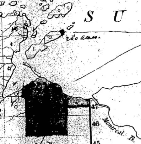
March 30th, 1855 map from the U.S. General Land Office of lands to be withheld from sale for the La Pointe (Bad River) Reservation from the National Archives Microfilm Publications; Microcopy No. 27; Roll 16; Volume 16. The northeast corner of the Reservation along Lake Superior is accurately located at the mouth of Ke-che-se-be-we-she Creek (not labeled) on this map.
The undersigned persons connected with the Odanah Mission, upon the Bad River Reservation, and also a portion of those Chiefs who were present and signed the Treaty of Sept 30th, AD 1854, would most respectfully call your attention to a few Statements affecting the interests of the Indians within the limits of the Lake Superior Agency, with a view to soliciting from you such action as will speedily see one to the several Indian Bands named, all of the benefits guaranteed to them by treaty stipulation.
Under the Treaty concluded at La Pointe Sept 30th, 1854 the United States set apart a tract of Land as a Reservation “for the La Pointe Band and such other Indians as may see fit to settle with them” bounded as follows.
a.k.a.
Ke-che-se-be-we-she
“Ke-che” (Gichi) refers to big, or large.
“se-be” (ziibi) refers to a river.
“we-she” (wishe) refers to rivulets.
Source: Gidakiiminaan Atlas by the Great Lakes Indian Fish & Wildlife Commission
“Beginning on the South shore of Lake Superior a few miles west of Montreal River at the mouth of a creek called by the Indians Ke-she-se-be-we-she, running thence South &c.”

Detail of the Bad River Reservation from GLIFWC’s Gidakiiminaan Atlas. This map clearly shows that the northeast boundary of Bad River Reservation is not located at the true location of Ke-che-se-be-we-she Creek in accordance with the 1854 Treaty. Red highlights added for emphasis of discrepancies.
Your petioners would represent that at the time of the wording of this particular portion of the Treaty, the commissioner on the part of the United States inquired the number of miles between the mouth of the Montreal River and the mouth of the creek referred to, in reply to which, the Indians said “they had no knowledge of distance by miles” and therefore the commissioner assumed the language of “a few miles west of Montreal River” as discriptive of the creek in mind. This however, upon actual examination of the ground, does to the Band the greatest injustice, as the mouth of the creek to which the Indians referred at the time is even less than one mile west of the mouth of the Montreal.*
*This creek at the time was refered to as having “Deep water inside the Bar” sufficient for Boats which is definitive of the creek still claimed as the starting point, and is not descriptive of the most westerly creek.
But White men, whose interests are adverse to those of the Indians now demand that the Reservation boundary commence at an insignificant and at times scarcely visible creek some considerable distance west of the one referred to in the Treaty, which would lessen the aggregate of the Reservation from 3 to 4000 acres.
Your petioners, have for years, desired and solicited a settlement of the matter, both for the good of the Indians and of the Whites, but from lack of interest the administrations in power have paid no attention to our appeals, as is also true of other matters to which we now call your attention.
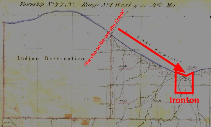
1861 resurvey of Township 47 North of Range 1 West by Elisha S. Norris for the General Land Office relocating Bad River Reservation’s northeast boundary. Ke-che-se-be-we-she Creek was relocated to what is now Graveyard Creek instead of its true location at the Barber Brother’s Ironton townsite location. Red highlights added for emphasis of discrepancies.
As many heads of families now wish to select (within the portion of Town 47 North of Range 1 West belonging to the Reservation the 80 acre tract assigned to them) we desire that the Eastern Boundary of the Reservation be immediately established so that the subdivisions may be made and and land selected.
Your petioners would further [represent?] that under the 3d Section of the 2nd article of the Treaty referred to the Lac De Flabeau, and Lac Court Orelles Bands are entitled to Reservations each equal to 3 Townships, (See article 3d of Treaty. These Reservations have never been run out, none have any subdivisions been made.) which also were to be subdivided into 80 acre Tracts.
Article 4th promises to furnish each of the Reservations with a Blacksmith and assistant with the usual amount of Stock, where as the Lac De Flambeau Band have never yet had a Blacksmith, though they have repeatedly asked for one.

Wisconsin State Representative
and co-founder of Ashland
Asaph Whittlesey
As the matters have referred to one of vital importance to these several Bands of Indians, we earnestly hope that you will give your influence towards securing to them, all of the benefits named in the Treaty and as the subject named will demand labor entirely outside of the ordinary duties of an Indian Agent, and as it will be important for some one to visit the Reservations Inland, so as to be able to report intelligently upon the actual State of Things, we respectfully suggest that Mr Asaph Whittlesey be specially commissioned (provided you approve of the plan and you regard him as a suitable person to act) to attend to the taking of the necessary depositions and to present these claims, with the necessary maps and Statistics, before the Commissioner of Indian Affairs at Washington, the expense of which must of necessity, be met by the Indian Department.
Mr Whittlesey was present at the making of the Treaty to which we refer, and is well acquainted with the wants of the Indians and with what they of right can claim, and in him we have full confidence.
In addition to the points herein named should you favor this commission, we would ask him to attend to other matters affecting the Indians, upon which we will be glad to confer with you at a proper time.
The undersigned L H Wheeler and Henry Blatchford have no hesitency in saying that the representations here made are full in accordance with their understanding of the Treaty, at the time it was drawn up, they being then present and the latter being one of the Interpreters at the time employed by the General Government.
Most Respectfully Yours
Dated Odanah Wis July 1861
Names of those connected with the Odanah Mission
[None identified on this draft petition]
Names of Chiefs who were signers to the Treaty of Sept 30th 1854
[None identified on this draft petition]
Although this draft was not signed by Wheeler or Blatchford, or by the tribal leadership that they appear to be assisting, Chequamegon History believes it is possible that a signed original copy of this petition may still be found somewhere in national archives if it still exists.
Reconstructing the “Martell” Delegation through Newspapers
November 2, 2013

Symbolic Petition of the Chippewa Chiefs: This pictographic petition was brought to Washington D.C. by a delegation of Ojibwe chiefs and their interpreter J.B. Martell. This one, representing the band of Chief Oshkaabewis, is the most famous, but their were several others copied from birch bark by Seth Eastman and published in the works of Henry Schoolcraft. For more, follow this link.
Henry Schoolcraft. William W. Warren. George Copway. These names are familiar to any scholar of mid-19th-century Ojibwe history. They are three of the most referenced historians of the era, and their works provide a great deal of historical material that is not available in any other written sources. Copway was Ojibwe, Warren was a mix-blood Ojibwe, and Schoolcraft was married to the granddaughter of the great Chequamegon chief Waabojiig, so each is seen, to some extent, as providing an insider’s point of view. This could lead one to conclude that when all three agree on something, it must be accurate. However, there is a danger in over-relying on these early historians in that we forget that they were often active participants in the history they recorded.
This point was made clear to me once again as I tried to sort out my lingering questions about the 1848-49 “Martell” Delegation to Washington. If you are a regular reader, you may remember that this delegation was the subject of the first post on this website. You may also remember from this post, that the group did not have money to get to Washington and had to reach out to the people they encountered along the way.
The goal of the Martell Delegation was to get the United States to cede back title to the lands surrounding the major Lake Superior Ojibwe villages. The Ojibwe had given this land up in the Treaty of 1842 with the guarantee that they could remain on it. However, by 1848 there were rumors of removal of all the bands east of the Mississippi to unceded land in Minnesota. That removal was eventually attempted, in 1850-51, in what is now called the Sandy Lake Tragedy.
The Martell Delegation remains a little-known part of the removal story, although the pictographs remain popular. Those petitions are remembered because they were published in Henry Schoolcrafts’ Historical and statistical information respecting the history, condition, and prospects of the Indian tribes of the United States (1851) along with the most accessible primary account of the delegation:
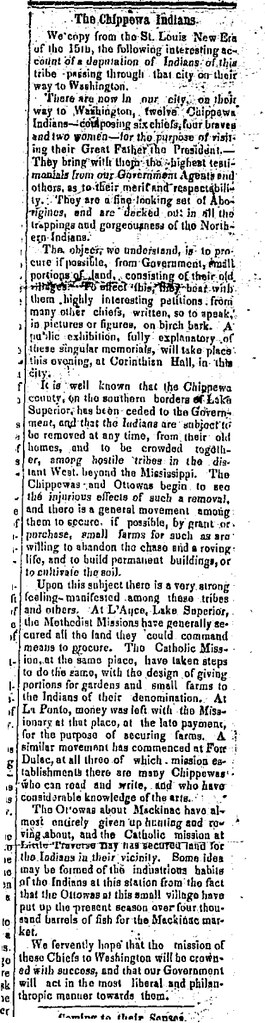
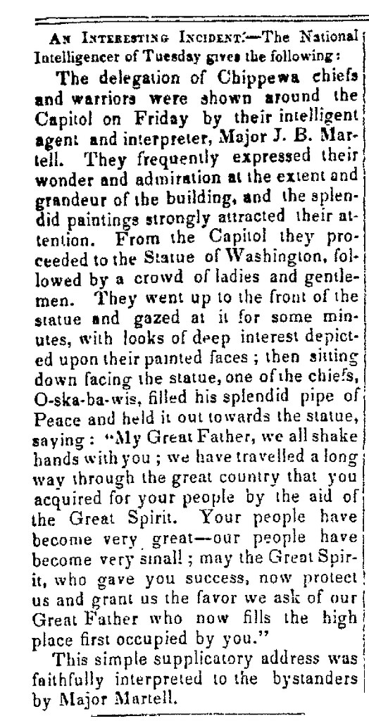
In the month of January, 1849, a delegation of eleven Chippewas, from Lake Superior, presented themselves at Washington, who, amid other matters not well digested in their minds, asked the government for a retrocession of some portion of the lands which the nation had formerly ceded to the United States, at a treaty concluded at Lapointe, in Lake Superior, in 1842. They were headed by Oshcabawiss, a chief from a part of the forest-country, called by them Monomonecau, on the head-waters of the River Wisconsin. Some minor chiefs accompanied them, together with a Sioux and two boisbrules, or half-breeds, from the Sault Ste. Marie, Michigan. The principal of the latter was a person called Martell, who appeared to be the master-spirit and prime mover of the visit, and of the motions of the entire party. His motives in originating and conducting the party, were questioned in letters and verbal representations from persons on the frontiers. He was freely pronounced an adventurer, and a person who had other objects to fulfil, of higher interest to himself than the advancement of the civilization and industry of the Indians. Yet these were the ostensible objects put forward, though it was known that he had exhibited the Indians in various parts of the Union for gain, and had set out with the purpose of carrying them, for the same object, to England. However this may be, much interest in, and sympathy for them, was excited. Officially, indeed, their object was blocked up. The party were not accredited by their local agent. They brought no letter from the acting Superintendent of Indian Affairs on that frontier. The journey had not been authorized in any manner by the department. It was, in fine, wholly voluntary, and the expenses of it had been defrayed, as already indicated, chiefly from contributions made by citizens on the way, and from the avails of their exhibitions in the towns through which they passed; in which, arrayed in their national costume, they exhibited their peculiar dances, and native implements of war and music. What was wanting, in addition to these sources, had been supplied by borrowing from individuals.
Engraving of Henry Schoolcraft by Wellstood and Peters (Photo credit: Wikipedia)
Martell, who acted as their conductor and interpreter, brought private letters from several persons to members of Congress and others, which procured respect. After a visit, protracted through seven or eight weeks, an act was passed by Congress to defray the expenses of the party, including the repayment of the sums borrowed of citizens, and sufficient to carry them back, with every requisite comfort, to their homes in the north-west. While in Washington, the presence of the party at private houses, at levees, and places of public resort, and at the halls of Congress, attracted much interest; and this was not a little heightened by their aptness in the native ceremonies, dancing, and their orderly conduct and easy manners, united to the attraction of their neat and well-preserved costume, which helped forward the object of their mission.
The visit, although it has been stated, from respectable sources, to have had its origin wholly in private motives, in the carrying out of which the natives were made to play the part of mere subordinates, was concluded in a manner which reflects the highest credit on the liberal feelings and sentiments of Congress. The plan of retrocession of territory, on which some of the natives expressed a wish to settle and adopt the modes of civilized life, appeared to want the sanction of the several states in which the lands asked for lie. No action upon it could therefore be well had, until the legislatures of these states could be consulted (pg. 414-416, pictographic plates follow).

I have always had trouble with Schoolcraft’s interpretation of these events. It wasn’t that I had evidence to contradict his argument, but rather that I had a hard time believing that all these chiefs would make so weighty a decision as to go to Washington simply because their interpreter was trying to get rich. The petitions asked for a permanent homeland in the traditional villages east of the Mississippi. This was the major political goal of the Lake Superior Ojibwe leadership at that time and would remain so in all the years leading up to 1854. Furthermore, chiefs continued to ask for, or go “uninvited” on, diplomatic missions to the president in the years that followed.
I explored some of this in the post about the pictograph, but a number of lingering questions remained:
What route did this group take to Washington?
Who was Major John Baptiste Martell?
Did he manipulate the chiefs into working for him, or was he working for them?
Was the Naaganab who went with this group the well-known Fond du Lac chief or the warrior from Lake Chetek with the same name?
Did any chiefs from the La Pointe band go?
Why was Martell criticized so much? Did he steal the money?
What became of Martell after the expedition?
How did the “Martell Expedition” of 1848-49 impact the Ojibwe removal of 1850-51?
Lacking access to the really good archives on this subject, I decided to focus on newspapers, and since this expedition received so much attention and publicity, this was a good choice. Enjoy:
Indiana Palladium. Vevay, IN. Dec. 2, 1848
Capt. Seth Eastman of the U.S. Army took note of the delegation as it traveled down the Mississippi from Fort Snelling to St. Louis. Eastman, a famous painter of American Indians, copied the birch bark petitions for publication in the works of his collaborator Henry Schoolcraft. At least one St. Louis paper also noticed these unique pictographic documents.
 Lafayette Courier. Lafayette, IN. Dec. 8, 1848.
The delegation made its way up the Ohio River to Cincinnati, where Gezhiiyaash’s illness led to a chance encounter with some Ohio Freemasons. I won’t repeat it here, but I covered this unusual story in this post from August.
At Cincinnati, they left the river and headed toward Columbus. Just east of that city, on the way to Pittsburgh, one of the Ojibwe men offered some sound advice to the women of Hartford, Ohio, but he received only ridicule in return.
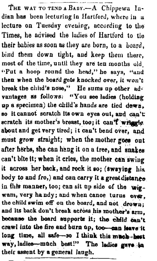
Madison Weekly Courier. Madison, IN. Jan. 24, 1849

It’s unclear how quickly reports of the delegation came back to the Lake Superior country. William Warren’s letter to his cousin George, written in March after the delegation had already left Washington, still spoke of St. Louis:
William W. Warren (Wikimedia Images)
“…About Martells Chiefs. They were according to last accounts dancing the pipe dance at St. Louis. They have been making monkeys of themselves to fill the pockets of some cute Yankee who has got hold of them. Black bird returned from Cleveland where he caught scarlet fever and clap. He has behaved uncommon well since his return…” (Schenck, pg. 49)

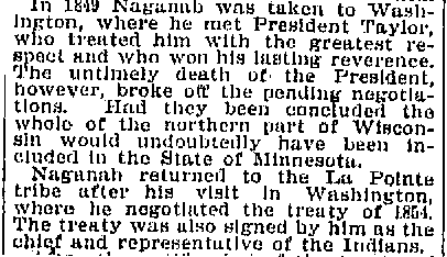
From this letter, we learn that Blackbird, the La Pointe chief, was originally part of the group. In evaluating Warren’s critical tone, we must remember that he was working closely with the very government officials who withheld their permission. Of the La Pointe chiefs, Blackbird was probably the least accepting of American colonial power. However, we see in the obituary of Naaganab, Blackbird’s rival at the 1855 annuity payment, that the Fond du Lac chief was also there.
New York World. New York. July 22, 1894
Before finding this obituary, I had thought that the Naaganab who signed the petition was more likely the headman from Lake Chetek. Instead, this information suggests it was the more famous Fond du Lac chief. This matters because in 1848, Naaganab was considered the speaker for his cousin Zhingob, the leading chief at Fond du Lac. Blackbird, according to his son James, was the pipe carrier for Buffalo. While these chiefs had their differences with each other, it seems likely that they were representing their bands in an official capacity. This means that the support for this delegation was not only from “minor chiefs” as Schoolcraft described them, or “Martells Chiefs” as Warren did, from Lac du Flambeau and Michigan. I would argue that the presence of Blackbird and Naaganab suggests widespread support from the Lake Superior bands. I would guess that there was much discussion of the merits of a Washington delegation by Buffalo and others during the summer of 1848, and that the trip being a hasty money-making scheme by Martell seems much less likely.
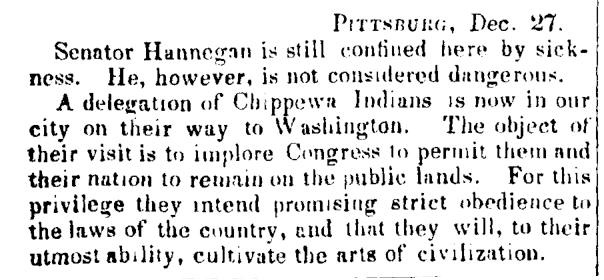
Madison Daily Banner. Madison, IN. Jan. 3, 1849.
From Pittsburgh, the delegation made it to Philadelphia, and finally Washington. They attracted a lot of attention in the nation’s capital. Some of their adventures and trials: Oshkaabewis and his wife Pammawaygeonenoqua losing an infant child, the group hunting rabbits along the Potomac, and the chiefs taking over Congress, are included this post from March, so they aren’t repeated here.
Adams Sentinel. Gettysburg, PA. Feb. 5, 1849.
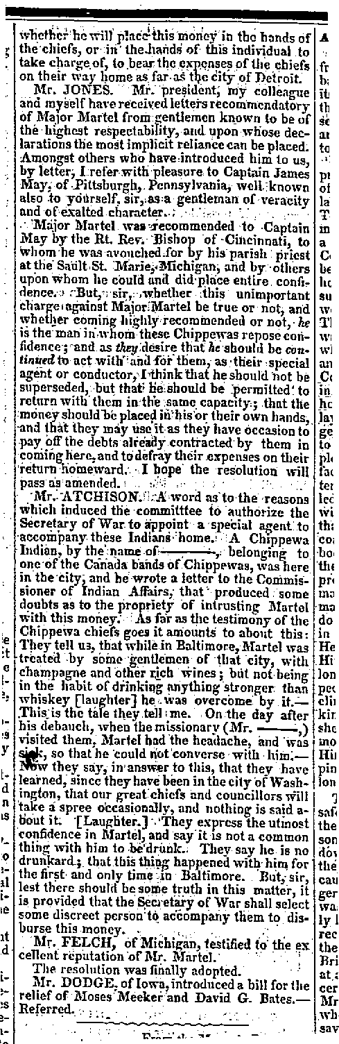
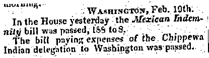
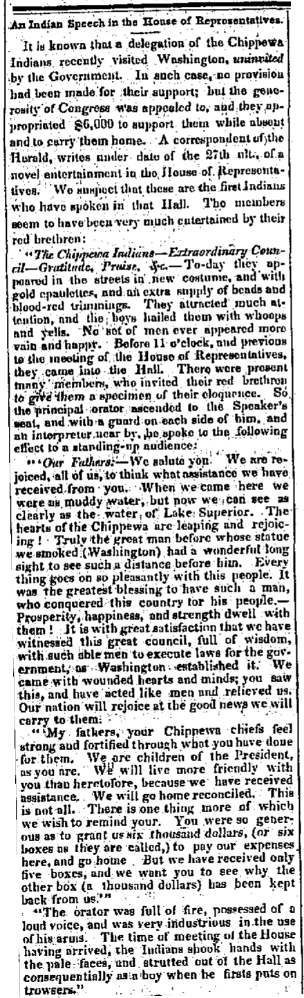
According to Ronald Satz, the delegation was received by both Congress and President Polk with “kindly feelings” and the expectation of “good treatment in the future” if they “behaved themselves (Satz 51).” Their petition was added to the Congressional Record, but the reservations were not granted at the time. However, Congress did take up the issue of paying for the debts accrued by the Ojibwe along the way.


George Copway (Wikimedia Commons)
Kah-Ge-Ga-Gah-Bowh (George Copway), a Mississauga Ojibwe and Methodist missionary, was the person “belonging to one of the Canada Bands of Chippewas,” who wrote the anti-Martell letter to Indian Commissioner William Medill. This is most likely the letter Schoolcraft referred to in 1851. In addition to being upset about the drinking, Copway was against reservations in Wisconsin. He wanted the government to create a huge pan-Indian colony at the headwaters of the Missouri River.

William Medill (Wikimedia Commons)
Iowa State Gazette. Burlington, IA. April 4, 1849
~~~~~~~~~~~~~~~~~~
~~~~~~~~~~~~~~~~~~~~~~~~~~~~~~~~~~~~~~~~~~~~~~~~~~~~~~~~~
 Weekly Wisconsin. Milwaukee. Feb. 28, 1849.
With $6000 (or did they only get $5000?), a substantial sum for the antebellum Federal Government, the group prepared to head back west with the ability to pay back their creditors.
It appears the chiefs returned to their villages by going back though the Great Lakes to Green Bay and then overland.
The Chippewa Delegation, who have been on a visit to see their “great fathers” in Washington, passed through this place on Saturday last, on their way to their homes near Lake Superior. From the accounts of the newspapers, they have been lionized during their whole journey, and particularly in Washington, where many presents were made them, among the most substantial of which was six boxed of silver ($6,000) to pay their expenses. They were loaded with presents, and we noticed one with a modern style trunk strapped to his back. They all looked well and in good spirits (qtd. in Paap, pg. 205).
Green Bay Gazette. April 4, 1849
So, it hardly seems that the Ojibwe chiefs returned to their villages feeling ripped off by their interpreter. Martell himself returned to the Soo, and found a community about to be ravaged by a epidemic of cholera.
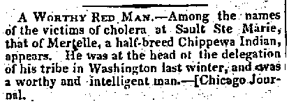
Weekly Wisconsin. Milwaukee. Sep. 5, 1849.
Martell appears in the 1850 census on the record of those deceased in the past year. Whether he was a major in the Mexican War, whether he was in the United States or Canadian military, or whether it was even a real title, remains a mystery. His death record lists his birthplace as Minnesota, which probably connects him to the Martells of Red Lake and Red River, but little else is known about his early years. And while we can’t say for certain whether he led the group purely out of self-interest, or whether he genuinely supported the cause, John Baptiste Martell must be remembered as a key figure in the struggle for a permanent Ojibwe homeland in Wisconsin and Michigan. He didn’t live to see his fortieth birthday, but he made the 1848-49 Washington delegation possible.
So how do we sort all this out?
To refresh, my unanswered questions from the other posts about this delegation were:
1) What route did this group take to Washington?
2) Who was Major John Baptiste Martell?
3) Did he manipulate the chiefs into working for him, or was he working for them?
4) Was the Naaganab who went with this group the well-known Fond du Lac chief or the warrior from Lake Chetek with the same name?
5) Did any chiefs from the La Pointe band go?
6) Why was Martell criticized so much? Did he steal the money?
7) What became of Martell after the expedition?
8) How did the “Martell Expedition” of 1848-49 impact the Ojibwe removal of 1850-51?
We’ll start with the easiest and work our way to the hardest. We know that the primary route to Washington was down the Brule, St. Croix, and Mississippi to St. Louis, and from there up the Ohio. The return trip appears to have been via the Great Lakes.
We still don’t know how Martell became a major, but we do know what became of him after the diplomatic mission. He didn’t survive to see the end of 1849.
The Fond du Lac chief Naaganab, and the La Pointe chief Blackbird, were part of the group. This indicates that a wide swath of the Lake Superior Ojibwe leadership supported the delegation, and casts serious doubt on the notion that it was a few minor chiefs in Michigan manipulated by Martell.
Until further evidence surfaces, there is no reason to support Schoolcraft’s accusations toward Martell. Even though these allegations are seemingly validated by Warren and Copway, we need to remember how these three men fit into the story. Schoolcraft had moved to Washington D.C. by this point and was no longer Ojibwe agent, but he obviously supported the power of the Indian agents and favored the assimilation of his mother-in-law’s people. Copway and Warren also worked closely with the Government, and both supported removal as a way to separate the Ojibwe from the destructive influences of the encroaching white population. These views were completely opposed to what the chiefs were asking for: permanent reservations at the traditional villages. Because of this, we need to consider that Schoolcraft, Warren, and Copway would be negatively biased toward this group and its interpreter.
Finally there’s the question Howard Paap raises in Red Cliff, Wisconsin. How did this delegation impact the political developments of the early 1850s? In one sense the chiefs were clearly pleased with the results of the trip. They made many friends in Congress, in the media, and in several American cities. They came home smiling with gifts and money to spread to their people. However, they didn’t obtain their primary goal: reservations east of the Mississippi, and for this reason, the following statement in Schoolcraft’s account stands out:
The plan of retrocession of territory, on which some of the natives expressed a wish to settle and adopt the modes of civilized life, appeared to want the sanction of the several states in which the lands asked for lie. No action upon it could therefore be well had, until the legislatures of these states could be consulted.
“Kindly feelings” from President Polk didn’t mean much when Zachary Taylor and a new Whig administration were on the way in. Meanwhile, Congress and the media were so wrapped up in the national debate over slavery that they forgot all about the concerns of the Ojibwes of Lake Superior. This allowed a handful of Indian Department officials, corrupt traders, and a crooked, incompetent Minnesota Territorial governor named Alexander Ramsey to force a removal in 1850 that resulted in the deaths of 400 Ojibwe people in the Sandy Lake Tragedy.
It is hard to know how the chiefs felt about their 1848-49 diplomatic mission after Sandy Lake. Certainly their must have been a strong sense that they were betrayed and abandoned by a Government that had indicated it would support them, but the idea of bypassing the agents and territorial officials and going directly to the seat of government remained strong. Another, much more famous, “uninvited” delegation brought Buffalo and Oshogay to Washington in 1852, and ultimately the Federal Government did step in to grant the Ojibwe the reservations. Almost all of the chiefs who made the journey, or were shown in the pictographs, signed the Treaty of 1854 that made them.
Sources:
McClurken, James M., and Charles E. Cleland. Fish in the Lakes, Wild Rice, and Game in Abundance: Testimony on Behalf of Mille Lacs Ojibwe Hunting and Fishing Rights / James M. McClurken, Compiler ; with Charles E. Cleland … [et Al.]. East Lansing, MI: Michigan State UP, 2000. Print.
Paap, Howard D. Red Cliff, Wisconsin: A History of an Ojibwe Community. St. Cloud, MN: North Star, 2013. Print.
Satz, Ronald N. Chippewa Treaty Rights: The Reserved Rights of Wisconsin’s Chippewa Indians in Historical Perspective. Madison, WI: Wisconsin Academy of Sciences, Arts and Letters, 1991. Print.
Schenck, Theresa M. William W. Warren: The Life, Letters, and times of an Ojibwe Leader. Lincoln: University of Nebraska, 2007. Print.
Schoolcraft, Henry Rowe, and Seth Eastman. Historical and Statistical Information Respecting the History, Condition, and Prospects of the Indian Tribes of the United States: Collected and Prepared under the Direction of the Bureau of Indian Affairs per Act of Congress of March 3rd, 1847. Philadelphia: Lippincott, Grambo, 1851. Print.
