Early Life among the Indians: Chapter I
September 26, 2017
By Amorin Mello

Early Life among the Indians
by Benjamin Green Armstrong

Early Indian History.
—
CHAPTER I.
—
The First Treaty.—The Removal Order.— Treaties of 1837 and 1842.—A Trip to Washington.—In New York City with Only One Dime.—At the Broker’s Residence.
My earliest recollections in Northern Wisconsin and Minnesota territories date back to 1835, at which time Gen. Cass and others on the part of the Government, with different tribes of Indians, viz : Potawatomies, Winnebagos, Chippewas, Saux and Foxes and the Sioux, at Prairie du Chien, met in open council, to define and agree upon boundary lines between the Saux and Foxes and the Chippewas. The boundary or division of territory as agreed upon and established by this council was the Mississippi River from Prairie du Chien north to the mouth of of Crow Wing River, thence to its source. The Saux and Foxes and the Sioux were recognized to be the owners of all territory lying west of the Mississippi and south of the Crow Wing River. The Chippewas, by this treaty, were recognized as the owners of all lands east of the Mississippi in the territory of Wisconsin and Minnesota, and north of the Crow Wing River on both sides of the Mississippi to the British Possessions, also Lake Superior country on both sides of the lake to Sault Ste. Marie and beyond. The other tribes mentioned in this council had no interest in the above divided territory from the fact that their possessions were east and south of the Chippewa Country, and over their title there was no dispute. The division lines were agreed to as described and a treaty signed. When all shook hands and covenanted with each other to live in peace for all time to come.
In 1837 the Government entered into a treaty with the Chippewas of the Mississippi and St. Croix Rivers at St. Peter, Minnesota, Col. Snelling, of the army, and Maj. Walker, of Missouri, being the commissioners on the part of the Government, and it appears that at the commencement of this council the anxiety on the part of the commissioners to perfect a treaty was so great that statements were made by them favorable to the Indians, and understood perfectly by them, that were not afterwards incorporated in the treaty. The Indians were told by these commissioners that the great father had sent them to buy their pine timber and their minerals that were hidden in the earth, and that the great father was very anxious to dig the mineral, for of such material he made guns and knives for the Indians, and copper kettles in which to boil their sugar sap.
“The timber you make but little use of is the pine your great father wants to build many steamboats, to bring your goods to you and to take you to Washington bye-and-bye to see your great father and meet him face to face. He does not want your lands, it is too cold up here for farming. He wants just enough of it to build little towns where soldiers stop, mining camps for miners, saw mill sites and logging camps. The timber that is best for you the great father does not care about. The maple tree that you make your sugar from, the birch tree that you get bark from for your canoes and from which you make pails for your sugar sap, the cedar from which you get material for making canoes, oars and paddles, your great father cares nothing for. It is the pine and minerals that he wants and he has sent us here to make a bargain with you for it,” the commissioners said.
And further, the Indians were told and distinctly understood that they were not to be disturbed in the possession of their lands so long as their men behaved themselves. They were told also that the Chippewas had always been good Indians and the great father thought very much of them on that account, and with these promises fairly and distinctly understood they signed the treaty that ceded to the government all their territory lying east of the Mississippi, embracing the St. Croix district and east to the Chippewa River, but to my certain knowledge the Indians never knew that they had ceded their lands until 1849, when they were asked to remove therefrom.

Robert Stuart was an American Fur Company agent and Acting Superintendent on Mackinac Island.
~ Wikipedia.org
In 1842 Robert Stewart, on the part of the government, perfected a treaty at La Pointe, on Lake Superior, in which the Chippewas of the St. Croix and Superior country ceded all that portion of their territory, from the boundary of the former treaty of 1837, with the Chippewas of the Mississippi and St. Croix Indians, east and along the south shore of the lake to the Chocolate River, Michigan, territory. No conversation that was had at this time gave the Indians an inkling or caused them to mistrust that they were ceding away their lands, but supposed that they were simply selling the pine and minerals, as they had in the treaty of 1837, and when they were told, in 1849, to move on and thereby abandon their burying grounds — the dearest thing to an Indian known— they began to hold councils and to ask each as to how they had understood the treaties, and all understood them the same, that was : That they were never to be disturbed if they behaved themselves. Messengers were sent out to all the different bands in every part of their country to get the understanding of all the people, and to inquire if any depredations had been committed by any of their young men, or what could be the reason for this sudden order to move. This was kept up for a year, but no reason could be assigned by the Indians for the removal order.
The treaty of 1842 made at La Pointe stipulated that the Indians should receive their annuities at La Pointe for a period of twenty-five years. Now by reason of a non-compliance with the order to move away, the annuity payment at La Pointe had been stopped and a new agency established at Sandy Lake, near the Mississippi River, and their annuities taken there, and the Indians told to go there for them, and to bring along their women and children, and to remain there, and all that did not would be deprived of their pay and annuities.
In the fall of 1851, and after all the messengers had returned that had been sent out to inquire after the cause for the removal orders, the chiefs gathered in council, and after the subject had been thoroughly canvassed, agreed that representatives from all parts of the country should be sent to the new agency and see what the results of such a visit would be. A delegation was made up, consisting of about 500 men in all. They reached the new agency about September 10th of that year. The agent there informed them that rations should be furnished to them until such time as he could get the goods and money from St. Paul.
Some time in the latter part of the month we were surprised to hear that the new agency had burned down, and, as the word came to us,
“had taken the goods and money into the ashes.”
The agent immediately started down the river, and we saw no more of him for some time. Crowds of Indians and a few white men soon gathered around the burnt remains of the agency and waited until it should cool down, when a thorough search was made in the ashes for melted coin that must be there if the story was true that goods and money had gone down together. They scraped and scratched in vain All that was ever found in that ruin in the shape of metal was two fifty cent silver pieces. The Indians, having no chance to talk with the agent, could find out nothing of which they wished to know. They camped around the commissary department and were fed on the very worst class of sour, musty pork heads, jaws, shoulders and shanks, rotten corned beef and the poorest quality of flour that could possibly be milled. In the course of the next month no fewer than 150 Indians had died from the use of these rotten provisions, and the remainder resolved to stay no longer, and started back for La Pointe.
At Fond du Lac, Minnesota, some of the employees of the American Fur Co. urged the Indians to halt there and wait for the agent to come, and finally showed them a message from the agent requesting them to stop at Fond du Lac, and stated that he had procured money and goods and would pay them off at that point, which he did during the winter of 1851. About 500 Indians gathered there and were paid, each one receiving four dollars in money and a very small goods annuity. Before preparing to leave for home the Indians wanted to know of the agent, John S. Waters, what he was going to do with the remainder of the money and goods. He answered that he was going to keep it and those who should come there for it would get their share and those that did not would get nothing. The Indians were now thoroughly disgusted and discouraged, and piling their little bundles of annuity goods into two piles agreed with each other that a game of lacrosse should be played on the ice for the whole stock. The Lake Superior Indians were to choose twenty men from among them and the interior Indians the same number. The game was played, lasting three days, and resulting in a victory for the interiors. During all this time councils were being held and dissatisfaction was showing itself on every hand. Threats were freely indulged in by the younger and more resolute members of the band, who thought while they tamely submitted, to outrage their case would never grow better. But the older and more considerate ones could not see the case as they did, but all plainly saw there was no way of redress at present and they were compelled to put up with just such treatment as the agent saw fit to inflict upon them. They now all realized that they had been induced to sign treaties that they did not understand, and had been imposed upon. They saw that when the annuities were brought and they were asked to touch the pen, they had only received what the agent had seen fit to give them, and certainly not what was their dues. They had lost 150 warriors on this one trip alone by being fed on unwholesome provisions, and they reasoned among themselves :
Is this what our great father intended? If so we may as well go to our old home and there be slaughtered where we can be buried by the side of our relatives and friends.
These talks were kept up after they had returned to La Pointe. I attended many of them, and being familiar with the language, I saw that great trouble was brewing and if something was not quickly done trouble of a serious nature would soon follow. At last I told them if they would stop where they were I would take a party of chiefs, or others, as they might elect, numbering five or six, and go to Washington, where they could meet the great father and tell their troubles to his face. Chief Buffalo and other leading chieftains of the country at once agreed to the plan, and early in the spring a party of six men were selected, and April 5th, 1852, was appointed as the day to start. Chiefs Buffalo and O-sho-ga, with four braves and myself, made up the party. On the day of starting, and before noon, there were gathered at the beach at old La Pointe, Indians by the score to witness the departure. We left in a new birch bark canoe which was made for the occasion and called a four fathom boat, twenty-four feet long with six paddles. The four braves did most of the paddling, assisted at times by O-sho-ga and sometimes by Buffalo. I sat at the stern and directed the course of the craft. We made the mouth of the Montreal River, the dividing line between Wisconsin and Michigan, the first night, where we went ashore and camped, without covering, except our blankets. We carried a small amount of provisions with us, some crackers, sugar and coffee, and depended on game and fish for meat. The next night, having followed along the beach all day, we camped at Iron River. No incidents of importance happened, and on the third day out from La Pointe, at 10 a. m. we landed our bark at Ontonagon, where we spent two days in circulating a petition I had prepared, asking that the Indians might be left and remain in their own country, and the order for their removal be reconsidered. I did not find a single man who refused to sign it, which showed the feeling of the people nearest the Indians upon the subject. From Ontonagon we went to Portage Lake, Houghton and Hancock, and visited the various copper mines, and all there signed the petition. Among the signers I would occasionally meet a man who claimed personal acquaintance with the President and said the President would recognize the signature when he saw it, which I found to be so on presenting the petition to President Filmore. Among them was Thomas Hanna, a merchant at Ontonagon, Capt. Roberts, of the Minnesota mine, and Douglas, of the firm of Douglas & Sheldon, Portage Lake. Along the coast from Portage Lake we encountered a number of severe storms which caused us to go ashore, and we thereby lost considerable time. Stopping at Marquette I also circulated the petition and procured a great many signatures. Leaving there nothing was to be seen except the rocky coast until we reached Sault Ste. Marie, where we arrived in the afternoon and remained all the next day, getting my petition signed by all who were disposed. Among others who signed it was a Mr. Brown, who was then editing a paper there. He also claimed personal acquaintance with the President and gave me two or three letters of introduction to parties in New York City, and requested me to call on them when I reached the city, saying they would be much pleased to see the Indian chieftains from this country, and that they would assist me in case I needed assistance, which I found to be true.

The second day at the “Soo” the officers from the fort came to me with the inteligence that no delegation of Indians would be allowed to go to Washington without first getting permission from the government to do so, as they had orders to stop and turn back all delegations of Indians that should attempt to come this way en-route to Washington. This was to me a stunner. In what a prediciment I found myself. To give up this trip would be to abandon the last hope of keeping that turbulent spirit of the young warriors within bounds. Now they were peacably inclined and would remain so until our mission should decide their course. They were now living on the hope that our efforts would obtain for them the righting of a grievous wrong, but to return without anything accomplished and with the information that the great father’s officers had turned us back would be to rekindle the fire that was smoldering into an open revolt for revenge. I talked with the officers patiently and long and explained the situation of affairs in the Indian country, and certainly it was no pleasant task for me to undertake, without pay or hope of reward, to take this delegation through, and that I should never have attempted it if I had not considered it necessary to secure the safety of the white settlers in that country, and that although I would not resist an officer or disobey an order of the government, I should go as far as I could with my Indians, and until I was stopped by an officer, then I would simply say to the Indians,
“I am prevented from going further. I have done all I can. I will send you as near home, as I can get conveyances for you, but for the present I shall remain away from that country,”
The officers at the “Soo” finally told me to go on, but they said,
“you will certainly be stopped at some place, probably at Detroit. The Indian agent there and the marshall will certainly oppose your going further.”

More than one Steamer Northerner was on the Great Lakes in 1852. This may have been the one Chief Buffalo’s delegation rode on.
~ Great Lakes Maritime Database
But I was determined to try, and as soon as I could get a boat for Detroit we started. It was the steamer Northerner, and when we landed in Detroit, sure enough, we were met by the Indian agent and told that we could go no further, at any rate until next day, or until he could have a talk with me at his office. He then sent us to a hotel, saying he would see that our bill was paid until next day. About 7:30 that evening I was called to his office and had a little talk with him and the marshall. I stated to them the facts as they existed in the northwest, and our object in going to Washington, and if we were turned back I did not consider that a white man’s life would long be safe in the Indian country, under the present state of excitement; that our returning without seeing the President would start a fire that would not soon be quenched. They finally consented to my passing as they hardly thought they could afford to arrest me, considering the petitions I had and the circumstances I had related.
“But,” they also added, “we do not think you will ever reach Washington with your delegation.”
I thanked them for allowing us to proceed and the next morning sailed for Buffalo, where we made close connections with the first railroad cars any of us had ever seen and proceeded to Albany, at which place we took the Steamer Mayflower, I think. At any rate the boat we took was burned the same season and was commanded by Capt. St. John.

Lecture Room (theater) at Barnum’s American Museum circa 1853.
~ Commons.Wikimedia.org
We landed in New York City without mishap and I had just and only one ten-cent silver piece of money left. By giving the ‘bus driver some Indian trinkets I persuaded him to haul the party and baggage to the American House, which then stood a block or so from Barnum’s Theatre. Here I told the landlord of my financial embarrassment and that we must stay over night at any rate and in some way the necessary money to pay the bill should be raised. I found this landlord a prince of good fellows and was always glad that I met him. I told him of the letters I had to parties in the city and should I fail in getting assistance from them I should exhibit my fellows and in this way raise the necessary funds to pay my bill and carry us to our destination. He thought the scheme a good one, and that himself and me were just the ones to carry it out. Immediately after supper I started out in search of the parties to whom I had letters of introduction, and with the landlord’s help in giving me directions, I soon found one of them, a stock broker, whose name I cannot remember, or the street on which he lived. He returned with me to the hotel, and after looking the Indians over, he said,
“You are all right. Stay where you are and I will see that you have money to carry you through.”
The next day I put the Indians on exhibition at the hotel, and a great many people came to see them, most of whom contributed freely to the fund to carry us to our destination. On the second evening of the exhibition this stock broker came with his wife to the show, and upon taking his leave, invited me to bring the delegation to his house the next afternoon, where a number of ladies of their acquaintance could see them without the embarrassment they would feel at the show room. To this I assented, and the landlord being present, said he would assist by furnishing tho conveyance. But when the ‘bus was brought up in front of the house the next day for the purpose of taking the Indians aboard, the crowd became so dense that it was found impossible to get them into it, and it was with some difficulty that they were gotten back to their room. We saw it would not be possible to get them across the city on foot or by any method yet devised. I despatched a note to the broker stating how matters stood, and in less than half an hour himself and wife were at the hotel, and the ready wit of this little lady soon had a plan arranged by which the Indians could be safely taken from the house and to her home without detection or annoyance. The plan was to postpone the supper she had arranged for in the afternoon until evening, and that after dark the ‘bus could be placed in the alley back of the hotel and the Indians got into it without being observed. The plan was carefully carried out by the landlord. The crowd was frustrated and by 9 p. m. we were whirling through the streets with shaded ‘bus windows to the home of the broker, which we reached without any interruption, and were met at the door by the little lady whose tact had made the visit possible, and I hope she may now be living to read this account of that visit, which was nearly thirty-nine years ago. We found some thirty or forty young people present to see us, and I think a few old persons. The supper was prepared and all were anxious to see the red men of the forest at a white man’s table. You can imagine my own feelings on this occasion, for, like the Indians, I had been brought up in a wilderness, entirely unaccustomed to the society of refined and educated people, and here I was surrounded by them and the luxuries of a finished home, and with the conduct of my wards to be accounted for, I was forced to an awkward apology, which was, however, received with that graciousness of manner that made me feel almost at home. Being thus assured and advised that our visit was contemplated for the purpose of seeing us as nearly in our native ways and customs as was possible, and that no offense would be taken at any breach of etiquette, but, on the contrary, they should be highly gratified if we would proceed in all things as was our habit in the wilderness, and the hostess, addressing me, said it was the wish of those present that in eating their supper the Indians would conform strictly to their home habits, to insure which, as supper was then being put in readiness for them, I told the Indians that when the meal had been set before them on the table, they should rise up and pushing their chairs back, seat themselves upon the floor, taking with them only the plate of food and the knife. They did this nicely, and the meal was taken in true Indian style, much to the gratification of the assemblage. When the meal was completed each man placed his knife and plate back upon the table, and, moving back towards the walls of the room, seated himself upon the floor in true Indian fashion.
As the party had now seen enough to furnish them with tea table chat, they ate their supper and after they had finished requested a speech from the Indians, at least that each one should say something that they might hear and which I could interpret to the party. Chief O-sha-ga spoke first, thanking the people for their kindness. Buffalo came next and said he was getting old and was much impressed by the manner of white people and showed considerable feeling at the nice way in which they had been treated there and generally upon the route.
Our hostess, seeing that I spoke the language fluently, requested that I make them a speech in the Chippewa tongue. To do this so they would understand it best I told them a story in the Indian tongue. It was a little story about a monkey which I had often told the Indians at home and it was a fable that always caused great merriment among them, for a monkey was, in their estimation, the cutest and most wonderful creature in the world, an opinion which they hold to the present time. This speech proved to be the hit of the evening, for I had no sooner commenced (though my conversation was directed to the white people), than the Indians began to laugh and cut up all manner of pranks, which, combined with the ludicrousness of the story itself, caused a general uproar of laughter by all present and once, if never again, the fashionably dressed and beautiful ladies of New York City vied with each other and with the dusky aborigines of the west in trying to show which one of all enjoyed best the festivities. The rest of the evening and until about two o’clock next morning was spent in answering questions about our western home and its people, when we returned to the hotel pleased and happy over the evening’s entertainment.
To be continued in Chapter II…
By Amorin Mello
A curious series of correspondences from “Morgan”
… continued from Copper Harbor Redux.

The Daily Union (Washington D.C.)
“Liberty, The Union, And The Constitution.”
August 29, 1845.
EDITOR’S CORRESPONDENCE.
—
[From our regular correspondent.]
ST. LOUIS, Mo. Aug. 19, 1845.
One of the most interesting sections of the North American continent is the basin of the Upper Mississippi, being, as it is, greatly diversified by soil, climate, natural productions, &c. It embraces mineral lands of great extent and value, with immense tracts of good timber, and large and fertile bodies of farming land. This basin is separated by elevated land o the northeast, which divides the headwaters of rivers emptying into the Mississippi from those that flow into the lakes Superior and Michigan, Green Bay, &c. To the north and northwest, it is separated near the head of the Mississippi, by high ground, from the watercourses which flow towards Hudson’s bay. To the west, this extensive basin is divided from the waters of the Missouri by immense tracts of elevated plateau, or prairie land, called by the early French voyageurs “Coteau des Prairies,” signifying “prairie coast,” from the resemblance the high prairies, seen at a great distance, bear to the coast of some vast sea or lake. To the south, the basin of the Upper Mississippi terminates at the junction of the Mississippi with the Des Moines river.
The portion of the valley of the Mississippi thus described, if reduced to a square form, would measure about 1,000 miles each way, with St. Anthony’s falls near the centre.
1698 detail of Saint Anthony’s Falls and Lake Superior from Amerique Septentrionalis Carte d’un tres grand Pays entre le Nouveau Mexique et la Mer Glaciace Dediee a Guilliaume IIIe. Roy de La Grand Bretagne Par le R. P. Louis de Hennepin Mission: Recol: et Not: Apost: Chez c. Specht a Utreght 1698.
~ Commons.Wikimedia.org
For a long time, this portion of the country remained unexplored, except by scattered parties of Canadian fur-traders, &c. Its physical and topographical geography, with some notions of its geology, have, as it were, but recently attracted attention.

Douglas Volk painting of Father Hennepin at Saint Anthony Falls.
~ Commons.Wikimedia.org

Father Antoine “Louis” Hennepin
~ Wikipedia.org
Father Hennepin was no doubt the first white man who visited St. Anthony’s falls. In reaching them, however, he passed the mouth of St. Peter’s river, a short distance below, without noticing it, or being aware of its existence. This was caused by the situation of an island found in the Mississippi, directly in front of the mouth of St. Peter’s, which, in a measure, conceals it from view.
After passing the falls, Father Hennepin continued to ascend the Mississippi to the St. Francis river, but went no higher.

Portrait of Jonathan Carver from his book, Travels through the interior parts of North America in the years 1766, 1767 and 1768.
~ Wisconsin Historical Society
In the year 1766, three years after the fall of Canada, Captain Johnathan Carver, who had taken an active part as an officer in the English service, and was at the surrender of Fort William Henry, where (he says) 1,500 English troops were massacred by the Indians, (he himself narrowly escaping with his life,) prepared for a tour among the Indian tribes inhabiting the shores of the upper lakes and the upper valley of the Mississippi. He left Boston in June of the year stated, and, proceeding by way of Albany and Niagara, reached Mackinac, where he fitted out for the prosecution of his journey to the banks of the Mississippi.
From Mackinac, he went to Green Bay; ascended the Fox river to the country of the Winnebago Indians; from thence, crossing some portages, and passing through Lake Winnebago, he descended the Wisconsin river to the Mississippi river; crossing which, he came to a halt at Prairie du Chien, in the country of the Sioux Indians. At the early day, this was an important trading-post between French traders and the Indians. Carver says: “It contains about three hundred families; the houses are well built, after the Indian manner, and well situated, on a very rich soil, from which they raise every necessary of life in great abundance. This town is the great mart whence all the adjacent tribes – even those who inhabit the most remote branches of the Mississippi – annually assemble about the latter end of May, bringing with them their furs to dispose of to the traders.” Carver also noticed that the people living there had some good horses.
Detail of Prairie du Chien from Carver [Jonathan], Captain. Journal of his travels with maps and drawings, 1766.
~ Boston Public Library
The fur-trade, which at one time centred here, and gave it much consequence, has been removed to St. Peter’s river. Indeed, this trade, which formerly gave employment to so many agents, traders, trappers, &c., conferring wealth upon those prosecuting it, is rapidly declining on this continent; in producing which, several causes conspire. The first is, the animals caught for their furs have greatly diminished; and the second is, that competition in the trade has become more extensive and formidable, increasing as the white settlements continue to be pushed out to the West.
John Jacob Astor established the American Fur Company.
~ Wikipedia.com
At Prairie du Chien is still seen the large stone warehouse erected by John Jacob Astor, at a time when he ruled the trade, and realized immense profits by the business. The United States have a snug garrison at this place, which imparts more or less animation to the scene. It stands on an extensive and rather low plain, with high hills in the rear, running parallel with the Mississippi.
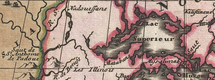
The house in which Carver lodged, when he visited this place, is still pointed out. There are some men living at this post, whose grandfather acted as interpreter to Carver. The Sioux Indians, whom Carver calls in his journal “the Nadowessies,” which is the Chippewa appellation for this tribe of Indians, keep up the tradition of Carver’s visit among them. The inhabitants, descendants of the first settlers at Prairie du Chien, now living at this place, firmly believe in the truth of the gift of land made to Carver by the Sioux Indians.
From this point Carver visited St. Anthony’s falls, which he describes with great accuracy and fidelity, accompanying his description with a sketch of them.
![Detail of Saint Anthony's Falls from Carver [Jonathan], Captain. Journal of his travels with maps and drawings, 1766. ~ Boston Public Library](https://chequamegonhistory.com/wp-content/uploads/2016/05/carver-detail-of-st-anthony-falls.jpg)
Detail of Saint Anthony’s Falls from Carver [Jonathan], Captain. Journal of his travels with maps and drawings, 1766.
~ Boston Public Library
From the Mississippi river Carver crossed over to the Chippewa river; up which he ascended to its source, and then crossed a portage to the head of the Bois Brulé, which he called “Goddard’s river.” Descending this latter stream to Lake Superior, he travelled around the entire northern shore of that lake from west to east, and accurately described the general appearance of the country, including notices of the existence of the copper rock on the Ontonagon, with copper-mineral ores at points along the northeastern shore of the lake, &c.
![Detail of "Goddard's River," La Pointe, and Ontonagon from Carver [Jonathan], Captain. Journal of his travels with maps and drawings, 1766. ~ Boston Public Library](https://chequamegonhistory.com/wp-content/uploads/2016/05/carver-detail-of-goddard-river-and-la-pointe.jpg)
Detail of “Goddard River,” La Pointe, and Ontonagon from Carver [Jonathan], Captain. Journal of his travels with maps and drawings, 1766.
~ Boston Public Library
He finally reached the Sault St. Marie, where he found a French Indian trader, (Monsieur Cadot,) who had built a stockade fort to protect him in his trade with the Indians.
![Detail of Sault Ste Marie from Carver [Jonathan], Captain. Journal of his travels with maps and drawings, 1766. ~ Boston Public Library](https://chequamegonhistory.com/wp-content/uploads/2016/05/carver-detail-of-sault-ste-marie.jpg)
Detail of Sault Ste Marie from Carver [Jonathan], Captain. Journal of his travels with maps and drawings, 1766.
~ Boston Public Library
Descendants of this Monsieur Cadot are still living at the Sault and at La Pointe. We met one of them returning to the latter place, in the St. Croix river, as we were descending it. They, no doubt, inherit strong claims to land at the falls of the St. Mary’s river, which must ere long prove valuable to them, if properly prosecuted.
From the Sault St. Marie, Carver went to Mackinac, then garrisoned by the English, where he spent the winter. The following year he reached Boston, having been absent about two years.
From Boston he sailed for England, with a view of publishing his travels, and securing his titles to the present of land the Sioux Indians have made him, and which it is alleged the English government pledged itself to confirm, through the command of the King, in whose presence the conveyance made to Carver by the Sioux Indians was read. He not only signified his approval of the grant, but promised to fit out an expedition with vessels to sail to New Orleans, with the necessary men, &c., which Captain Carver was to head, and proceed from thence to the site of this grant, to take possession of it, by settling his people on it. The breaking out of the American revolution suspended this contemplated expedition.
Captain Carver died poor, in London, in the year 1780, leaving two sons and five daughters. I consider his description of the Indians among whom he travelled, detailing their customs, manners, and religion, the best that has ever been published.
In this opinion I am sustained by others, and especially by old Mr. Duncan Graham, whom I met on the Upper Mississippi. He has lived among the Indians ever since the year 1783. He is now between 70 and 80 years old. He told me Carver’s book contained the best account of the customs and manners of the Indians he had ever read.
His valuable work is nearly out of print, it being rather difficult to obtain a copy. It went through three editions in London. Carver dedicated it to Sir Joseph Banks, president of the Royal Society. Almost every winter on the Indians and Indian character, since Carver’s time, has made extensive plagiarisms from his book, without the least sort of acknowledgement. I could name a number of authors who have availed themselves of Carver’s writings, without acknowledgement; but as they are still living, I do not wish to wound the feelings of themselves or friends.
One of the writers alluded to, gravely puts forth, as a speculation of his own, the suggestion that the Winnebagoes, and some other tribes of Indians now residing at the north, had, in former times, resided far to the south, and fled north from the wars and persecutions of the bloodthirsty Spaniards; that the opinion was strengthened from the fact, that the Winnebagoes retained traditions of their northern flight, and of the subsequent excursions of their war parties across the plains towards New Mexico, where, meeting with Spaniards, they had in one instance surprised and defeated a large force of them, who were travelling on horseback.
Now this whole idea originated with Carver; yet Mr. ——— has, without hesitation, adopted it as a thought or discovery as his own!

Alexander Henry, The Elder.
~ Wikipedia.com
The next Englishman who visited the northwest, and explored the shores of Lake Superior, was Mr. Henry, who departed from Montreal, and reached Mackinac through Lake Huron, in a batteau laden with some goods. His travels commenced, I believe, about 1773-‘4, and ended about 1776-‘7. Mr. Henry’s explorations were conducted almost entirely with the view of opening a profitable trade with the Indians. He happened in the country while the Indians retained a strong predilection in favor of the French, and strong prejudices against the English. It being about the period of the Pontiac war, he had some hazardous adventures among the Indians, and came near losing his life. He continued, however, to prosecute his trade with the Indians, to the north and west of Lake Superior. Making voyages along the shores of this lake, he became favorably impressed with the mineral appearances of the country. Finding frequently, through is voyageurs, or by personal inspections, rich specimens of copper ore, or of the metal in its native state, he ultimately succeeded in obtaining a charter from the English government, in conjunction with some men of wealth and respectability in London, for working the mines on Lake Superior. The company, after making an ineffectual attempt to reach a copper vein, through clay, near the Ontonagon, the work was abandoned, and was not afterwards revived.
General Cass, with Colonel Allen, &c., were the next persons to pass up the southern coast of Lake Superior, and, in going to the west and northwest of the lake, they travelled through Indian tribes in search of the head of the Mississippi river. Their travels and discoveries are well known to the public, and proved highly interesting.
Mr. Schoolcraft’s travels, pretty much over the same ground, have also been given to the public; as also the expedition of General Pike on the Upper Mississippi.

Major Stephen Harriman Long published his expedition as Voyage in a Six-oared Skiff to the Falls of St. Anthony in 1817.
~ Wikipedia.org
More lately, the basin of the Upper Mississippi has received a further and more minute examination under the explorations directed by Major Long, in his two expeditions authorized by government.

Joseph Nicholas Nicollet
~ Wikipedia.org
Lastly, Mr. J. N. Nicollet, a French savan, travelling for some years through the United States with scientific objects in view, made an extensive examination of the basin of the Upper Mississippi.
He ascended the Missouri river to the Council Bluffs; where, arranging his necessary outfit of men, horses, provisions, &c., (being supplied with good instruments for making necessary observations,) he stretched across a vast tract of country to the extreme head-waters of the St. Peter’s, determining, as he went, the heights of places above the ocean, the latitude and longitude of certain points, with magnetic variations. He reached the highland dividing the waters of the St. Peter’s from those of the Red river of the North. He descended the St. Peter’s to its mouth; examined the position and geology of St. Anthony’s falls, and then ascended the same river as high as the Crow-wing river. The secondary rock observed below the falls, changes for greenstone, sienite, &c., with erratic boulders. On the east side of the river, a little below Pikwabik, is a large mass of sienitic rock with flesh-colored feldspar, extending a mile in length, half a mile in width, and 80 feet high. This is called the Little Rock. Higher up, on the same side, at the foot on the Knife rapids, there are sources that transport a very fine, brilliant, and bluish sand, accompanied by a soft and unctuous matter. This appears to be the result of the decomposition of a steachist, probably interposed between the sienitic rocks mentioned. The same thing is observed at the mouths of the Wabezi and Omoshkos rivers.
Detail of Saint Anthony’s Falls and Saint Peter’s River from Hydrographical Basin of the Upper Mississippi River from Astronomical and Barometrical Observations Surveys and Information by Joseph Nicolas Nicollet, 1843.
~ David Rumsey Map Collection
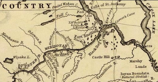
Ascending the Crow-wing river a short distance, Mr. Nicollet turned up Gull river, and proceeded as far as Pine river, taking White Fish lake in his way; and again ascended the east fork of Pine river, and reached Little Bay river, which he descended over rapids, &c., to Leech lake, where he spent some days in making astronomical observations, &c. From Leech lake, he proceeded, through small streams and lakes, to that in which the Mississippi heads, called Itasca. Having made all necessary observations at this point, he set out on his return down the Mississippi; and finally, reaching Fort Snelling at St. Peter’s, he spent the winter there.

Detail of Leech Lake and Lake Itasca from Hydrographical Basin of the Upper Mississippi River from Astronomical and Barometrical Observations Surveys and Information by Joseph Nicolas Nicollet, 1843.
~ David Rumsey Map Collection
Lake Itasca, in which the Mississippi heads, Mr. Nicollet found to be about 1,500 feet above the level of the ocean, and lying in lat. about 47° 10′ north, and in lon. 95° west of Greenwich.
This vast basin of the Upper Mississippi forms a most interesting and valuable portion of the North American continent. From the number of its running streams and fresh-water lakes, and its high latitude, it cannot fail to prove a healthy residence for its future population.
It also contains the most extensive body of pine timber to be found in the entire valley of the Mississippi, and from which the country extending from near St. Anthony’s falls to St. Louis, for a considerable distance on each side of the river, and up many of its tributaries, must draw supplies of lumber for building purposes.
In addition to these advantages, the upper basin is rich in mines of lead and copper; and it is not improbable that silver may also be found. Its agricultural resources are also very great. Much of the land is most beautifully situated, and fertile in a high degree. The climate is milder than that found on the same parallel of latitude east of the Alleghany mountains. Mr. Nicollet fixes the mean temperature at Itasca lake at 43° to 44°; and at St. Peter’s near St. Anthony’s falls, at 45° to 46°

“Maiden Rock. Mississippi River.“ by Currier & Ives. Maiden’s Rock Bluff. This location is now designated as Maiden Rock Bluff State Natural Area.
~ SpringfieldMuseums.org
Every part of this great basin that is arable will produce good wheat, potatoes, rye, oats, Indian corn to some extent, fine grasses, fruits, garden vegetables, &c. There is no part of the Mississippi river flanked by such bold and picturesque ranges of hills, with flattened, broad summits, as are seen extending from St. Anthony’s falls down to Prairie du Chien, including those highlands bordering Lake Pepin, &c. Among the cliffs of sandstone jutting out into perpendicular bluffs near the river, (being frequently over 100 feet high,) is seen one called Maiden’s rock. it is said an Indian chief wished to force his daughter to marry another chief, while her affections were placed on another Indian; and that, rather than yield to her father’s wishes, she cast herself over this tall precipice, and met an instant death. On hearing of which, her real lover, it is said, also committed suicide. Self-destruction is very rare among the Indians; and we imagine, when it does occur, it must be produced by the strongest kind of influence over their passions. Mental alienation, if not entirely unknown among them, must be exceedingly rare. I have no recollection of ever having heard of a solitary case.
From St. Anthony’s falls to St. Louis is 900 miles. The only impediment to the regular navigation of the river by steamboats, is experienced during low water at the upper and lower rapids.
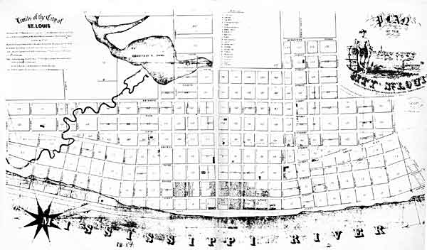
“St. Louis Map circa 1845”
~ CampbellHouseMuseum.org
The first are about 14 miles long, with a descent of only about 25 feet. The lower rapids are 11 miles long, with a descent of 24 feet. In each case, the water falls over beds of mountain or carboniferrous limestone, which it has worn into irregular and crooked channels. By a moderate expenditure of money on the part of the general government, which ought to be made as early as practicable, these rapids could be permanently opened to the passage of boats. As it is at present, boats, in passing the rapids at low water, and especially the lower rapids, have to employ barges and keel-boats to lighten them over, at very great expense.
From the rapid settlement of the country above, with the increasing trade in lumber and lead, the business on the Upper Mississippi is augmenting at a prodigious rate. When the river is sufficiently high to afford no obstruction on the lower rapids, not less than some 28 or 30 boats run regularly between Galena and St. Louis – the distance being 500 miles. Besides these, two or three steam packets run regularly to St. Anthony’s falls, or to St. Peter’s, near the foot of them. Every year will add greatly to the number of these boats. Other fine large and well-found packets run from St. Louis to Keokuk, at the foot of the lower rapids, four miles below which the Des Moines river enters the Mississippi river. It is the opinion of Mr. Nicollet, that this river can be opened, by some slight improvements, for 100 miles above its mouth. It is said the extensive body of land lying between the Des Moines and the Mississippi, and running for a long distance parallel with the left bank of the latter, contains the most lovely,rich and beautiful land to be found on the continent, if not in the world. It is already pretty thickly settled. Splendid crops of wheat and corn have been raised on farms opened upon it, the present year. Much of the former we found had already arrived at depots on the river, in quantities far too great to find a sufficient number of boats, at the present low water, to carry it to market.
I do not see but the democratic party are regularly gaining strength throughout the great West, as the results of the recent elections, which have already reached you, sufficiently indicate.
Those who wish to obtain more general, as well as minute information, respecting the basin of the Upper Mississippi, I would recommend to consult the able report, accompanied with a fine map of the country, by Mr. J. N. Nicollet, and reprinted by order of the Congress at their last session.
I am, very respectfully,
Your obedient servant,
MORGAN.
This curious series of correspondences from “Morgan” is continued in the September 1 and September 5 issues of The Daily Union, where he arrived in New York City again after 4,200 miles and two and a half months on this delegation. As those articles are not pertinent to the greater realm of Chequamegon History, this concludes our reproduction of these curious correspondences.
The End.
By Amorin Mello
In our Penoka Survey Incidents series earlier this year, we followed some of the adventures and schemes of Albert Conrad Stuntz circa 1857. The legacy of Albert’s influential survey still defines the geopolitical landscape of the Penokee Mountains to this day. However, Albert’s work during the late 1850s was relatively minor in comparison to that of his brother, George Riley Stuntz, during the early 1850s. The surveying work of George and his employees started in 1852 and enabled the infamous land speculators and townsite promotors of Superior City to manifest their schemes by early 1854 (months before the Treaty of La Point occurred later that year).
Among the men that worked with George was Augustus Hamilton Barber. Sometime around 1850, Augustus had followed his Grandparents, Aunts, Uncles, and Cousins from the Barber family of Lamoille County, Vermont, to Lancaster in Grant County, Wisconsin. After a short career as a school teacher in Grant County, Augustus came to Lake Superior in 1852 employed by George as a Chainman under his contract with the United States General Land Office to survey lands at the Head of Lake Superior.
Before taking a closer look at the Barber Papers, let’s examine the lives and affairs of other surveyors and speculators along the southwest shore of Lake Superior, starting with George Riley Stuntz and his production of these Exterior Field Notes (June of 1852):


Duluth and St. Louis County, Minnesota;
Their Story and People
By Walter Van Brunt, 1921, pages 64-65.

Portrait of George Nettleton’s cabin on Minnesota Point in 1852 on page 75.
First Settler.– The honor, for both Superior and Duluth, must presumably go to George R. Stuntz. He came in 1852, and settled in 1853. Several were earlier of course, but can hardly be considered to have been legitimate independent settlers. Carlton had been on the ground, at Fond du Lac, for some years, but he was Indian agent; Borup and Oaks had spent their time between La Pointe and Fond du Lac, but were then at St. Paul, and mainly interested in the development of that city, and in fur trading. Wm. R. Marshall stated that he “was on the lake as early as 1848,” but not to settle and he did not come again until 1857. Wm. R. Marshall and George R. Stuntz were fellow-surveyors, in federal pay, “back in the ’40s,” but Marshall did not seek to take the place of Stuntz as premier pioneer at the head of Lake Superior. As a matter of fact, although “on the lake as early as “1848,” Marshall did not then get nearer to Duluth than La Pointe, where he met “Borup and Oaks, the principal traders, Truman Warren, George Nettleton, Cruttenden, Wattrous, Rev. Sherman Hall, E. F. Ely and others.” It is quite possible that Stuntz was with Marshall in 1848, for that was the year in which Stuntz first entered Minnesota territory “having charge of a surveying party that was working near Lake Pepin and in what is now Washington County.”
The “Heart of the Continent.”– George R. Stuntz prepared the way for the first attempt at white settlement at the head of Lake Superior. He surveyed the land on the Wisconsin side, within a year of beginning which survey, in 1852, the first settlers began to appear. George R. Stuntz came by direction of George B. Sargent, who at the time was surveyor-general of the Iowa, Wisconsin and Minnesota district for the federal government, his headquarters being at Davenport, Iowa. In that year, states Carey, “he surveyed and definitely located a portion of the northeastern boundary line between Minnesota and Wisconsin, starting from the head of navigation on the St. Louis River, at Fond du Lac, and running south to the St. Croix River.” Stuntz himself stated: “I came in 1852. I saw the advantages of this point (Minnesota Point) as clearly then as I do now (1892). On finishing the survey for the government, I went away to make a report, and returned the next spring and came for good. I saw as surely then as I do now that this was the heart of the continent commercially, and so I drove my stakes.”
![Group of people, including a number of Ojibwe at Minnesota Point, Duluth, Minnesota [featuring William Howenstein] ~ University of Minnesota Duluth, Kathryn A. Martin Library](https://chequamegonhistory.com/wp-content/uploads/2015/06/howenstein-minnesota-point.jpg)
Group of people, including a number of Ojibwe at Minnesota Point, Duluth, Minnesota [featuring William Howenstein in 1872?] ~ University of Minnesota Duluth
The Vanguard.– He did not come alone, needing of course assistants in the work of surveying, but he was in charge of the work, Gand necessarily takes first place in the accounting. William C. Sargent, son of George B. Sargent, stated in 1916, that his father “came here (Duluth) first in 1852 with George R. Stuntz and Bill Howenstein,” and goes on to state “a word of those two grand men, George R. Stuntz and Bill Howenstein.” He believed that “to George R. Stuntz, more than to any other man belongs the honor (of) opening up that region,” and of Howenstein, he said: “And old Bill Howenstein, one of the best ever, and always my very good friend, a kindly body, with a quaint dry humor unsurpassed and seldom met with in these later days. I had many an interesting chat with him, in his home on Minnesota Point, that he built in 1852, and lived in until his death, some years ago.” Bill Howenstein, undoubtedly was of Stuntz’ party in 1852, but it is doubtful whether he built a log house on Minnesota Point in that year. As to General Sargent’s visit in 1852. If he did come then, it was probably only a flying visit. His interest in the head of Lake Superior in 1852 reached only to the extent of directing Stuntz to survey it. He, himself, had the surveying business of three states to attend to.
The New York Times
[December 11, 1852]
The Region about the Southwest End of Lake Superior.
Mr. Stuntz, of Grant County, Wis., has been deputed by the general Land Surveyor of this Northwest District to lay off such a tract of land about the southwest point of the lake into townships and sections, as emigrants will earliest require. He returned via La Pointe and Stillwater last week. We have obtained from him some new views of that region. From Fond du Lac, a trading post situated 11 miles inland on the St. Louis River, eastward, for perhaps 50 miles, the margin of the lake is a flat strip of land reaching back to a rocky ridge about 11 miles off. The soil of this flat land is a rich red clay. The wood is white cedar and pine of the most magnificent growth. The American line is beyond the mouth of the St. Louis and Pigeon rivers. It evidently abounds in copper, iron and silver. The terrestrial compass cannot be used there, so strong is the attraction to the earth. The needle rears and plunges “like mad.” Points of survey have to be fixed by the solar compass.
The Indian and half breed packmen have astonishing strength. One Indian, who is described by the others as being as large as two men, carried for a company of 11 men provisions for ten days, viz: one barrel of flour, half barrel of pork and something else, beside the utensils. Mirage is a common phenomenon is Spring and Summer. For the bays not opening as soon as the main lake, or not cooling so early, an object out on the lake, is viewed from the shore, through a dense medium of air and a thin medium. Hence is a refraction of rays which gives so many wonderful sights that the Chippewas call that the spirit or enchanted land. Sail vessels which are really 40 miles off, are seen flapping and bellying about almost within touch. Turreted Islands, look heavy and toppling towards the zenith. Forests seem to leap from their stems and go a soaring like thistles for the very sport of it.
The ice did not leave some of the bays till the 10th of June. The fish are delicious, especially the salmon trout. But little land game. Mr. Stunts calculates on wonderful enterprises in that country after the opening of the Saut Canal.
Mr. S. describes La Pointe a town of the Lake, as being situated at the head of a bay some 25 miles from the high lake, and secluded from the lake by several islands. He saw there a warehouse 300 feet long, built of tamarac poles, and roofed with bark. This building is very much warped by the pressure of age ; it is entered by a wooden railway. The town is dingy and dreary. He saw a most luxurious garden by the former residence of Dr. Borup. It contained a variety of fruit trees and shrubs, such as plums, cherries, apples, pears, currants, &c.

Cover of Stuntz’s Exterior Field Notes (August-October 1852) ~ Wisconsin Public Land Survey Records: Original Field Notes and Plat Maps

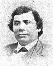
George Riley Stuntz was also assisted by his brother Albert Conrad Stuntz as well as the African-Chippewa mixed-blood Stephen Bonga employed as an Axeman. To learn more about the interesting Bonga (Bonza) family and Stephen as “the first white child born at the head of Lake Superior,” read pages 39-41 of The Black West by William Loren Katz (1971), and pages 131-34 of Black Indians also by Katz (2012).
The Eye of the North-west: First Annual Report of the Statistician of Superior, Wisconsin
By Frank Abial Flower, 1890

Portrait of Stephen Bonga, page 7.
GEORGE R. STUNTZ, DEPUTY U. S. SURVEYOR [pages 50-52]

Portrait of George Riley Stuntz, page 26.
In 1852 George R. Stuntz took a contract to run the township lines in this part of the country, including the state boundary, and filed with the land-office at Dubuque a rude map of the head of the lake, on the Wisconsin side, in December of that year. He took a new contract and returned in the spring of 1853 to survey the copper range around Black River, a few miles south of Superior. He brought seeds with him and planting them on the Namdji, raised a quantity of vegetables; they grew to great size. he also built a trading-post on Minnesota point near the present light-house, and a mill on Iron River in Bayfield county. In respect of these operations W. W. Ward writes from Morley, Mo.:
The first lumber of any description produced locally, other than by “Whip sawing”, was at Iron River, Wisconsin about forty miles from Superior on the South Shore of Lake Superior.
George R. Stuntz with William C. Howenstein, Andrew Reefer and George Falkner built and operated a water power “up and down” sawmill at the falls on Iron River about a half a mile from the Lake, capable of cutting three thousand feet of lumber a day. The writer has several 1 1/4 inch absolutely “clear” White Pine boards 24 and 26 inches wide and 18 feet long that were originally stored in a loft to be used in building a skiff. This mill was built in 1854 and the lumber was floated up the Lake to Superior, Oneota and Fond du Lac…
~ Superior, Wisconsin, papers, 1831-1942 ([unpublished])
From “A Pioneer of Old Superior” by Lillian Kimball Stewart
“In the summer of ’54 the Sam Ward plying between the Sault and any port on Lake Superior, brought on every trip a goodly number of emigrants, speculators, and tourists, bent on seeing the new “city” of Superior. Stuntz’s dock was located near an Indian village, so that every traveler as well as every piece of freight or baggage was subject to inspection by braves, squaws, and papooses before receiving a passport to the shore across the bay…”
~ Superior, Wisconsin, papers, 1831-1942 ([unpublished])
“It was in the spring of 1853 that Mr. Stuntz, Deputy U. S. Surveyor, received his second contract to survey and run the township lines taking in the range around Black River Falls, a portion of Left-hand River country and that part where Superior now is. In the latter part of April that year he organized a party – viz., Nat. W. Kendall, James McKinzie, Pain Bradt, James McBride, Harvey Fargo, Wm. H. Reed, John Chisholm, Joseph Latham, Augustus Barber, and your humble servant. Procured three birch-bark canoes and supplies at Stillwater, Minn.: left there the first day of May, passed up the St. Croix River to its head, made a portage of about two and a half miles into the headwaters of the Brule River, down said river into Lake Superior, thence up the lake to what was called the entry of St. Louis Bay [now Superior Bay], and landed on Minnesota Point in the early part of June. At that time there were no white settlers in this end of the lake – all Chippewa Indians and ‘breeds’ – scarcely a stick missing on that side of the bay where Superior City now stands. We finished the surveying contract and went in early fall down to Iron River, built a double log-shanty, and made other preparations for the construction of a saw mill. Here the first lumber was made at the head of the lake and the first road opened through to the settlement on the St. Croix. The following February, Mr. Stuntz having a trading-post on Minnesota Point [then Stuntz’s Point], I went there and assisted in building a block-house and steamboat pier, and found improvements and a few log-shanties built where old Superior now is located.”
[…]
HUSTLING FOR TOWNSITES [pages 58-60]
Vincent Roy Jr. ~ Life and Labors of Rt. Rev. Frederic Baraga by Chrysostom Verwyst,
VI. – Superior.
Vincent [Roy Jr.] had barely emerged from the trouble just described when it was necessary for him to exert himself in another direction. A year or so previously he had taken up a claim of land at the headwaters of Lake Superior and there was improvement now on foot for that part of the country, and danger for his interests.
The ship canal at Sault St Marie was in course of construction and it was evidently but a question of days that boats afloat on Lakes Huron and Michigan would be able to run up and unload their cargo for regions further inland somewhere on the shore at the further end of Lake Superior, at which a place, no doubt, a city would be built. The place now occupied by the city of Superior was suitable for the purposes in view but to set it in order and to own the greatest possible part of it, had become all at the same time the cherished idea of too many different elements as that developments could go on smoothly. Three independent crews were struggling to establish themselves at the lower or east end of the bay when a fourth crew approached at the upper or west end, with which Vincent, his brother Frank, and others of LaPointe had joined in. As this crew went directly to and began operations at the place where Vincent had his property it seems to have been guided by him, though it was in reality under the leadership of Wm. Nettleton who was backed by Hon. Henry M. Rice of St. Paul. Without delay the party set to work surveying the land and “improving” each claim, as soon as it was marked off, by building some kind of a log-house upon it. The hewing of timber may have attracted the attention of the other crews at the lower end about two or three miles off, as they came up about noon to see what was going on. The parties met about halfway down the bay at a place where a small creek winds its way through a rugged ravine and falls into the bay. Prospects were anything but pleasant at first at the meeting; for a time it seemed that a battle was to be fought, which however did not take place but the parceling out of ‘claims’ was for the time being suspended. This was in March or April 1854. Hereafter some transacting went on back the curtain, and before long it came out that the interests of the town-site of Superior, as far as necessary for efficient action, were united into a land company of which public and prominent view of New York, Washington, D.C. and other places east of the Mississippi river were the stockholders. Such interests as were not represented in the company were satisfied which meant for some of them that they were set aside for deficiency of right or title to a consideration. The townsite of the Superior of those days was laid out on both sides of the Nemadji river about two or three miles into the country with a base along the water edge about half way up Superior bay, so that Vincent with his property at the upper end of the bay, was pretty well out of the way of the land company, but there were an way such as thought his land a desirable thing and they contested his title in spite of his holding it already for a considerable time. An argument on hand in those days was, that persons of mixed blood were incapable of making a legal claim of land. The assertion looks more like a bugaboo invented for the purpose to get rid of persons in the way than something founded upon law and reason, yet at that time some effect was obtained with it. Vincent managed, however, to ward off all intrusion upon his property, holding it under every possible title, ‘preemption’ etc., until the treaty of LaPointe in the following September, when it was settled upon his name by title of United States scrip so called, that is by reason of the clause, as said above, entered into the second article of that treaty.
The subsequent fate of the piece of land here in question was that Vincent held it through the varying fortune of the ‘head of the lake’ for a period of about thirty six years until it had greatly risen in value, and when the west end was getting pretty much the more important complex of Superior, an English syndicate paid the sum of twenty five thousand dollars, of which was then embodied in a tract afterwards known as “Roy’s Addition”.
~ Biographical Sketch – Vincent Roy Jr; Vincent Roy Jr. Papers.
Up to the time of the survey in the spring of 1854 all was chaos as to lands west of the claims of Robertson, Nelson, Baker and their party. There could be no titles or bona fide purchases, as only the mouth of the Nemadji had been surveyed. There were really three “townsite” companies— Robertson, Nelson and Baker, with their associates J. A. Bullen, J. T. Morgan, E. Y. Shelly, August Zachau, C. G. Pettys, Abraham Emmett, and perhaps others, forming one which had the surveyed lands next to the Nemadji. West of them were Francis Roy, Benjamin Cadotte, Robert Bothwick, Basil Dennis, Charles Knowlton and nearly a dozen half-breeds, mostly brought from Crow Wing by Nettleton in the interest of what was known as the “Hollinshead crowd”—Edmund and Henry M. Rice, George L. Becker, Wm. and George W. Nettleton, Benjamin Thompson, James Stinson and W. H. Newton. Still farther west were Benjamin W. Brunson, A. A. Parker, R. F. Slaughter, C. D. Kimball, Rev. E. F. Ely, George R. Stuntz, Bradley Salter, Joseph Kimball, Calvin Hood, and others who proposed to call their town Endion—”Ahn-dy-yon,” the Chippewa for “home.”
B. W. Brunson, still a resident of St. Paul, has described the contest in writing. He says:
“Believing Superior would become of importance I went there in February, 1854, with R. F. Slaughter. We found some Ontonagon parties had claimed on the bay and we bought an interest in their claims and began to lay out a city and make improvements. While surveying the town, and when we had the same so far completed as to make a plat of it, the township having been subdivided by a good surveyor, then it was that Vincent Roy, Basil Dennis, Charles Brissette and Antoine Warren, accompanied by twenty-one other half-breeds and some four or five white men, headed, led and directed by one Stinson and one Thompson, who were acting for themselves and as agents of the company, came upon the lands to make their claims and avail themselves of pre-emption rights as citizens of the United States. These men were in the employ of the company for the purpose of making claims, and there was a claimant for each and every quarter-section as fast as the surveyor set the quarter-post. They had commenced the day before, with or at the same time the surveyor commenced his work. The timber being dense and there being a strong force, they were able to build an 8×10 cabin and cover it with boughs, upon each quarter, and then overtake the surveyor before he could establish the next quarter, thus taking the land as they went, and in that manner were progressing when they came upon the land marked out and occupied by us.“
The meeting of the two hostile parties occurred on the banks of the deep slough in what is now called Central Park. Nothing but the timidity of the half-breeds prevented bloodshed. Brunson was armed and intended to, and did stand his ground. Thompson, one of the pluckiest of men, was also armed, having two revolvers, and was prepared and intended to proceed. The Indians, not being armed, did not wish to engage in a battle where the leaders only were prepared to fight; and so there was no physical conflict, though a state of chaos and bad feeling continued for some time. Several cabins were demolished, Brunson’s party entirely cutting in pieces a house built by Basil Dennis on the ground now occupied by Dr. Conan’s fine residence.
A long legal contest followed. Finally in 1862-63 patents issued from the government to three men—S. W. Smith, Lars Lenroot and Oliver Lemerise—chosen as trustees of the townsite for the benefit of actual occupants. Thus those who claimed to be proprietors of, but not settlers on the townsite, lost their lands as well as their labor. In the winter of 1853-54 Henry M. Rice asked the Commissioner of the General Land Office whether, when lands which had not been surveyed were claimed for a townsite they would be liable to pre-emption as soon as the survey should be made. The answer was in favor of pre-emption; and that is how those who with Brunson put money into Superior City townsite lost it. The actual settlers got the townsite, the patent being made to the three trustees named who divided the plat, containing 240 acres with riparian rights in Superior Bay, and deeded lots to occupants and purchasers. It may be proper to mention here that a little plat of thirty-four acres, with riparian rights in the bay, and known as Middletown, went through a similar siege of litigation and was finally patented to three trustees —Urguelle Gouge, Louis Morrisette and Nicholas Poulliott—for the benefit of actual occupants. These decisions did not come until the “city” had collapsed and the land become nearly worthless.
The New York Times
[June 19th, 1858]
WESTERN LAND FRAUDS.
More Blood in the Body than Shows in the Face – Land Frauds in the Northwest – The Superior City Controversy – Pre-emptions by Swedes and Indians
Washington, Thursday, June 17, 1858.
Senator Henry Mower Rice
~ United States Senate Historical Office
There are some interesting matters here besides what takes place in Congress, and I propose from time to time to touch upon them. An expenditure of $60,000,000 per annum does not cover all the pickings and stealings that “prevail” in our hereabouts. Senator RICE did not tell all he knew about land-office operations, when he testified to the value of the Fort Snelling property. Nobody is better aware than he that the tract would be much better to cut up into town lots than Bayfield was when he bought it for a few cents an acre, and sold it for hundreds of dollars. If we could find out all that Senator BRIGHT knows of these matters, one could learn how to become a millionaire at very small expense of brains or labor. Indian treaties and land-office jobbing have made more men rich than care to tell of it – ask General CASS if this is not so.
Seeing a bushel-basket of papers in the Interior Department the other day, I was curious to know what the kernel might be to all that rind, and made inquiry in the premises. I was told that they enveloped the case of Superior City. I cast my eye over some of them, and noticed that an argument was filed on behalf of one of the parties by Mr. Senator BRIGHT – or rather with Senator BRIGHT’S indorsement. This whetted my desire of knowledge, and I ran my eye over the paper in question, which was from the pen of a Minnesota Judge and was without exception the richest document I ever saw intended for a judicial or administrative tribunal. The substance of it was that the opinion of the Attorney-General CUSHING in the case was absurd, the adoption of his views by the Interior Department preposterous, and the action of the local Land office at Superior, in defining the status of certain half-breed Indians on the most abundant testimony, corrupt. It was clear enough that such a document required at least a senatorial indorsement to justify its reception. Nobody can suppose for a moment that Senator BRIGHT has any interest in the result of the case, or that he expected to influence the judgement of his friend, HENDRICKS, (Commissioner of the General Land Office,) by appearing in it. That would be too strong an inference to draw from so meek a fact ; and yet the malicious might suggest it as an apprehension.

Original Proprietors of Superior featuring James Stinson, Benjamin Thomson, Dr. W.W. Coran, U.S. Senator Robert J Walker, George W. Cass, and Horace Bridge. Featured in The Eye of the North-west, pg. 8.
From the printed argument of Senator BRIGHT’S friend, and from a private abstract of the testimony in the case, and a few items I have picked up in the Land Office, I think it will be in my power to indite an epistle that may excite some attention. At the Southwestern extremity of Lake Superior, there is a tract of land, which is expected some day to become the cite of a large city. Being aware of its great advantages for this purpose, a St. Paul speculator by the name of THOMPSON, and a Canadian operator by the name of STINSON, undertook to possess themselves of it as long as as in the early part of General PIERCE‘S administration, by vicarious preemptions. In this plan they were assisted by some official gentlement, who shared in the spoils, and patents were ground out in double-quick time, or certificates issued to Swedes and Indians for the benefit of this STINSON and THOMPSON, and their associate speculators.
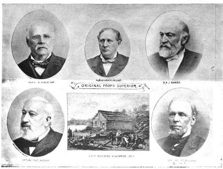
More Proprietors of Supeior from The Eye of the North-west, pg. 9.
In the Summer of 1854, this Mr. STINSON, headed a gang of Swedes and led them from Swede Lake, in the Territory of Minnesota, to Lake Superior, guiding them in person to the tracts he wished them to preempt. These men were ignorant of our language and of our laws, and were used by STINSON to “settle” their tracts, “prove up” their claims, and “convey” to him, the said STINSON, without knowing either the frauds they were practicing, or the rights which they might have secured to themselves if they had been acting in good faith. In the Land Office at Hudson, where these frauds were perpetrated, there was a notary public, who drew the deeds to STINSON, got the signatures of the Swedes to them and took the acknowledgements, immediately after the preemption oath had been administered – the Swedes thinking the whole operation a part of the preemption process. The terms were said to be $30 a month, and a bonus of $15 on the consummation of the bargain. The names of these Swedes were Aaron Peterson, Martin Larson, Peter Nelson, John Johnson, Sven Magnassan, Lorenz Johnson, Peter Norell, Sven Larson, Andreas Senson, Johannes Helon, Johannes Peterson, and Peter Erickson. These “preemptors,” for their own benefit, all “proved up” at Hudson, and the very same day they made conveyances to STINSON. The same thing is true of another Swedish invasion that was made in the Summer of 1855. In that year three Swedes – Old Westerland, Andrew Walmart, and Israel Janssen – commenced their settlements June 11, proved up June 22, and conveyed to STINSON June 22 – eleven days being sufficient for the whole operation. The records of the Land Office at Superior, and of the Register of Deeds of Douglas County, show these facts. They are well known in the General Land Office.
But Mr. STINSON did not operate through Swedes alone. He and his friend THOMPSON worked with half-breed Indians also. In March, 1854, he and THOMPSON followed up the Government Surveys with a gang of Chippewa half-breed Indians. The whole gang made preemptions in Douglas County, under the guidance of THOMPSON and STINSON, who hired them at La Pointe, and convered a large portion of a township with their fraudulent pre-emptions, which were proved up simultaneously, and simultaneously conveyed to the attorney of THOMPSON and STINSON. The names of all of this gang appear on the tract books in the General Land Office. These were Joseph Lamoureaux, Joseph Defaut, Joseph Dennis, Joseph Gauthier, Francis Decoteau, John B. Goslin, George D. Morrison and Levi B. Coffee, all preemptors for these land-sharks. There were three or four more half-breeds in the gang, who ran foul of some eight or ten American citizens who were seeking to save a slice of this Territory from Swedish and Indian preemption, and lay out a town site there under the law. This was the origin of the Superior City controversy, which has been pending some three or four years in the various land offices, and which has accumulated the basket of papers which first drew my attention to a case of such interesting dimensions. The contest is nominally between three or four Chippewa half-breeds claiming some three hundred acres as a town site. But the Indians are not merely bogus citizens, they are bogus pre-emptors in the bargain, for they were the hired men of THOMPSON & STINSON.
Mr. CUSHING decided in this controversy, before it was so settled by the Dred Scott case, that a half-breed Indian, receiving annuities as such, recognized as a dependent of a tribe, and the beneficiary of treaty stipulations, could become a citizen of the United States only by some positive act of Federal legislation ; that he could not, of his own volition, or by the laws of a State, change his condition from that of an Indian to that of a Federal citizen. Strange as it may seem, it appears that this part of the Dred Scott is repudiated by Mr. Commissioner HENDRICKS, who thinks a state cannot make a Federal citizen of a man with a drop of negro blood in his veins, but that the Commissioner of the General Land Office may naturalize Indians, ad libitum, without statute or judgement to sustain him.
I am curious to see how this controversy will be decided. The General Land Office upheld STINTSON’S Swedish preemption, on the ground that the frauds were discovered too late for the Commissioner to interefere. Whether or not STINSON hasmade any negro preemptions does not appear. It was too cold at the end of the lake for negroes to flourish much. But now it is to be settled in a case where the attempted frauds have been seasonably discovered, whether or not a Canadian adventurer can preempt whole townships of the Public Lands by the agency of a gang of half-breed Indians, and procure patents for them when the facts are known to the Federal authorities.
The pre-emptive right. Homesteads.
~ Superior, Wisconsin, papers, 1831-1942 ([unpublished])

Detail of Superior City townsite at the head of Lake Superior from Stuntz’s 1854 Plat Map of Township 49 North Range 14 West.
Early history of Superior should make mention of this right of acquisition, since there under, titles to government land were derived. Any qualified person might acquire title to one hundred and sixty acres of land by settling thereon, erecting a dwelling and making other improvements. Such person was to be twenty-one years of age, either male or female, or the head of a family whether man or woman.
Proof of each settlement was required to be made on a certain day at the United State Land Office and upon the payment of two hundred dollars with the taking of a required oath, the preemptioner got his one hundred and sixty acres of land.
But the whole proceeding, was far from straight, as a general thing, and in fact often amounted to a fraud.
“In the first place, Superior was backed by a powerful company of Democratic politicians and Government bankers in Washington, while the northern and northeastern portions of the state were still held by the Indians. This Superior company sought a connection with the Mississippi river, to obtain which they urged in congress the passage of a land grant bill, offering ten sections to the mile to aid in the construction of a railroad from Milwaukee to some point on Lake St. Croix, on the western boundary of the state of Wisconsin.”
~ History of Duluth and St. Louis County, Past and Present,
Volume 1, page 230.
Hence the whole country, in and about Superior, was dotted with preemption cabins, which were little more than logs piles up in walls, without floors, or windows, often with brush for a roof, a hole therein for a chimney and perhaps for a door. A slashing of half an acre or so of trees was the “improvement” so called. A very barbarous travesty, it was, upon a white man’s home and farm. Here is an instance, where as was said, a certain doctor of divinity laid claim to a quarter section of land, now in the midst of this city.
One day he sought “to prove up” his preemption, and one Alfred Allen was his witness, and they asked Allen, “Was the pre-emptions shanty good to live in?“, the law requiring a good habitable house on the claim. And Alf said “Yes, good for mosquitoes.” The Reverend said “Pshaw! Pshaw!” Meanding to upbraid or caution the witness who thereupon only protested and adjured the harder. The difficulty was somehow smoothed over, through some mending of the proofs, and perhaps connivance on the part of persons charged with administration of the United States land laws.
Nevertheless, it is interesting to member that upon rude and rough proceedings, such as are herein alluded to, rest at bottom the titles and claims to everything we own in the nature of lots, blocks, and land.
From: Statements of Hiram Hayes. Mr. Hayes came to Superior in 1854.
History of Duluth and St. Louis County, Past and Present, Volume 1
By Dwight Edwards Woodbridge, et al, 1910
GEORGE R. STUNTZ. [pages 229-231]
One of the earliest settlers at the head of the lakes was Mr. George E. Stuntz, who a short time ago joined the great majority. Before his death Mr. Stuntz wrote of his pioneer experiences as follows:
“In July, 1852, I came to the head of Lake Superior to run the land lines and subdivide certain townships. When I arrived at the head of the lakes there was nothing in Duluth or Superior. There was no settlement. The old American Fur Company had a post at La Pointe, at the west side of Madeline Island.
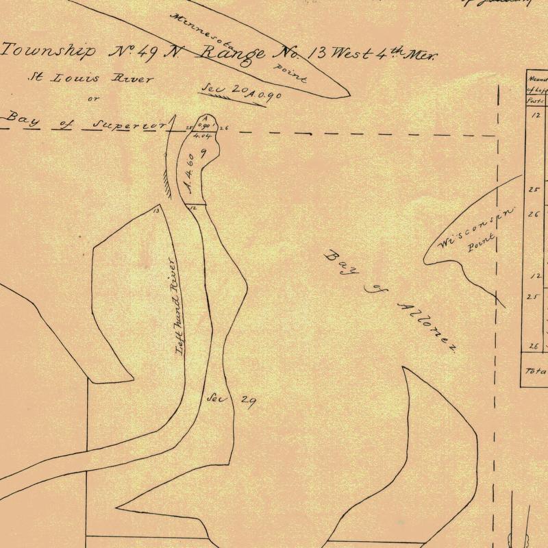
Detail of Minnesota Point from Stuntz’s Exterior Field Notes (August-October of 1852).
“In 1853 I got the range subdivided, and also in Superior, townsite 49, range 13. During the same year, later, in my absence, there came parties from the copper district of upper Michigan and located claims upon the range. They were principally miners. During the same year I built a residence on Minnesota Point under treaty license before the territory was sold to the Government. At that time there were only missionaries or license traders in the tract, as it belonged to the original Indian territory. In 1852, at Fond du Lac, there was a trading post and warehouse, in which I stored my goods on my arrival. In the fall of 1853 I bought three yoke of cattle and two cows at St. Croix Falls and brought them to the mouth of the Iron river, and had to cut a road thirty miles through the dense forest so as to get the oxen, cows and cart through. Later in the fall of 1853 I came through with an extra yoke of oxen, buying provisions, etc., and on coming up to Superior I found quite a settlement of log cabins. These settlers were anxious to get to the United States land office, then at Hudson, Wis. A dense forest intervened. We organized a volunteer company in January, 1854, to cut a road from old Superior to the nearest lumber camp on the St. Croix river, I furnishing two barrels of flour, provisions, pony and dog train, necessary to carry the provisions for a gang of seventeen men. The road was completed in twenty days, the snow being at that time two feet deep. This cut through a direct road to Taylor’s Falls and Stillwater. In 1854 I completed a mill on the Iron river and employed a man to superintend it, and I remained at Minnesota Point, my trading post, where I had first taken out the license. In the same year I took a contract to subdivide two townships located in Superior, townships 48-49, range 15, and afterward I attended the treaty at the time the Indians sold this country to the Government.
Before the 1854 Treaty of La Pointe could be ratified in Washington, D.C., the oral description agreed upon during the negotiations for exterior boundaries of the Chippewa treaties had to be surveyed with the tribe, documented, and delivered to Washington, D.C. before 1855. It is not clear who was involved with the exterior boundaries of these reservations; whether it was Stuntz, Barber, and/or others from their party.
“There were 5,000 Indians present with their chiefs. It was the biggest assemblage of Indians ever held at Lake Superior at this period of the country’s history. It took a month to pacify the troubles that grew among the different tribes in regard to their proportionate rights. This treaty was sent to congress September [30], 1854, and was ratified and became law in January, 1855.
To be continued in 1854…
Steamboats, Celebrities, Soo Shipping, and Superior Speculation: Joseph R. Williams’ Account of the 1855 Payment
July 30, 2014
By Leo
“They fade, they perish, as the grass of the prairies withers before the devouring element. The officers of our government, in their conference, have been accustomed to talk about the protection their Great Father vouchsafes to them, but it is the protection which the vulture affords the sparrow. Whatever may be the intentions of our professedly paternal government, no alternative seems to remain to the Indian, but submission to its crushing and onward march.”
-Joseph R. Williams, 1855

When Joseph R. Williams stepped out from the steamboat Planet onto the dock at La Pointe in August of 1855 he tried to make sense out of the scene before him. The arrival of the Toledo-based newspaper editor and hundreds of his fellow passengers, including dignitaries, celebrities, and politicians at Madeline Island coincided with the arrival of thousands of members of the Lake Superior Ojibwe bands for the first annuity payment under the Treaty of 1854.
The portrayal of the Chequamegon region in history would never be the same.
Prior to that year, the main story depicted in the written record is the expansion of the indigenous Ojibwe and Ojibwe-French mix-blood populations, their interactions with the nations of France, Britain, and the Dakota Sioux, and ultimately their attempt to defend their lands and sovereignty against an ever-encroaching United States.
After 1855, the Ojibwe and even the first-wave white settlers appear in the written history only as curious relics of a bygone age. They are an afterthought to the story of “progress”: shipping, real estate, mining, logging, and tourism. This second version of history, what I often call “Shipwrecks and Lighthouses” still dominates today. Much of it has been written by outsiders and newcomers, and it is a more sanitary history. It’s heavy on human triumph and light on controversy, but ultimately it conceals the earlier more-interesting history and its legacy.
If we could pick one event to mark this shift, what would it be? Was it the death of Chief Buffalo that summer of 1855? Was it the creation of the reservations? Was it the new Indian policies in Washington? While those events are related, and each is significant in its own right, none explains why the ideology of Manifest Destiny (as expressed by men like Williams) so swiftly and thoroughly took over the written record.
No, if there is one event that gets credit (or I would argue blame) for changing the tone of history in the summer of 1855, it was that the first vessels passed through the new canal at Sault Ste. Marie.
The Soo Locks and Superior
The St. Mary’s Falls Canal, or the Soo Locks as we commonly call them today, had been a dream of Great Lakes industrialists and the State of Michigan for years. In their view, Lake Superior was essentially cut off from the rest of the United States because all its water passes through Sault Ste. Marie, dropping over twenty feet as it drains into Lake Huron.
These falls, or more accurately rapids, were of immense economic, symbolic, and strategic value to the Ojibwe people. The French, British, and American governments also recognized their significance as a gateway to Lake Superior and beyond. However, for the merchants of Detroit, Cleveland, and Buffalo, drawn to Lake Superior by the copper mines of the Upper Peninsula or the rich iron deposits on the North Shore (opened up by the Treaty of 1854), the falls were only an obstacle to be overcome. Traders and speculators in the western part of Lake Superior also stood to gain from increased shipping traffic and eagerly watched the progress on the canal. We can see this in the amount of space Joseph Austrian, brother of La Pointe merchant Julius Austrian, gave the canal in his memoirs.
For the young city of Superior, the opening of the canal was seen as one of the critical steps toward becoming the next St. Louis or Chicago. In 1855, Duluth did not exist. Squatters had made claims on the Minnesota side under the Preemption Act, but the real action was on the Wisconsin side where a faction of Americans led by Col. D. A. Robinson was locked in a full-on real estate speculation battle with Sen. Henry M. Rice of Minnesota. Rice, had many La Pointe traders including Vincent Roy Jr. wrapped up in his scheme, but without the lifeline of the canal, neither faction would have the settlers, goods, or commerce necessary to grow the city beyond its few hundred residents.

Steamer North Star: From American Steam Vessels, page 40 by Samuel Ward Stanton (Wikimedia Images)
The Steamers

Port of Superior Arrivals Up to Sept. 25, 1855 (Superior Chronicle, 25 Sep. 1855)
When the first steamboats embarked on the lower Great Lakes in the 1810s, few large sailing vessels had ever appeared on Lake Superior. Birchbark canoes and Mackinac boats provided virtually all the shipping traffic. Brought by the copper rush in the Upper Peninsula, a few steamers appeared on Lake Superior in the late 1840s and early 1850s but these were modified from earlier sailing ships or painfully brought overland around the Sault. Once on Lake Superior, these vessels were confined and could no longer go back and forth to Mackinaw, Detroit, or beyond. These steamers did carry passengers, but primarily their job was to go back and forth from the copper mines to the Sault.
The opening of the canal on June 22, 1855, however, brought a new type of steamer all the way to the western end of Lake Superior. The North Star, Illinois, and Planet were massive, brightly-painted, beauties with grand dining halls with live music. They could luxuriously carry hundreds of passengers from Cleveland to Superior and back in a little over a week, a trip that had previously taken three weeks.
Decrease travel time also meant that news could travel back and forth much more quickly. Chequamegon Bay residents could get newspaper articles about unfolding war in the Crimea and the bloody fallout from the Kansas-Nebraska Act. And on June 12, 1855 the first issue of the weekly Superior Chronicle appeared off the presses of John C. Wise and Washington Ashton of Superior. The paper printed literature, world news, local events and advertisements, but large portions of its pages were devoted to economic opportunities and descriptions of the Superior area. Conspicuously absent from its pages is much mention at all of the politics of the local Ojibwe bands or any indication whatsoever that Ojibwe and mix-blooded families made up the largest percentage of the area’s population. In this way, the Chronicle, being backed by Henry Rice, was as much about promoting Superior to the outside world as it was about bringing news in.
Advertisements began to appear in the eastern papers…

New-York daily tribune. August 04, 1855 (Image provided by Library of Congress, Washington, DC Persistent link: http://chroniclingamerica.loc.gov/lccn/sn83030213/1855-08-04/ed-1/seq-3/)
…and the press took notice:
THE NEW YORK MIRROR says: “The fashionable watering places are not nearly as full as they were a year ago at this season; one reason for the falling off is, that thousands who have hitherto summered at these resorts have gone to Europe; and another is that the hard times of last autumn and winter have left their pinching reminiscences in many men’s purses.” The editor of the Sandusky Register seems to think that if these “fashionables” would cease to frequent Saratoga, Newport and Niagra, where $100 goes just far enough to make a waiter smile, there would be no cause for complaints of “too poor to spend the season North.”–When the snobs and devotees at the shrine of show and fashion learn that there are such places as Lake Superior, as the Islands in Lake Erie, as St. Catherines in Canada, where to live costs no more than a residence at home, we might suppose no further cause for complaint of poverty would exist. But the fact is, “go where the crowd goes or go not at all” is the motto with the fashionables; and until the places above named become popular resorts they will receive the attention only of those whose good sense leads them to prefer pure air, quiet, the pleasures of boating, bathing, fishing, &c., to the follies of Saratoga or Newport. To those who would enjoy a healthful and truly agreeable resort we can but commend the islands in Lake Erie, with a trip to the Upper Lake of Superior.
Bedford [IN] White River Standard, July 26, 1855

North Star: from American Steam Vessels by Samuel Ward Stanton, 1895 (Google Books).
By the time the August payment rolled around, steamers carrying hundreds of passengers from the highest rungs of American society. Chequamegon Bay had become a tourist destination.
The Tourists
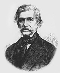
Prof. J. G. Kohl (Wikimedia Images)
Johann Georg Kohl is a familiar name to readers of the Chequamegon History website. Kohl’s Kitchi Gami, originally published in his native Germany, is a standard of Ojibwe cultural history and anthropology. His astute observations and willingness to actually ask questions about unfamiliar cultural practices of the people practicing them, created a work that has stood the test of time much better than those of his contemporaries. The modern reader will find Kohl’s depiction of Ojibwe people as actual intelligent human beings stands in refreshing contrast to most 19th-century works. Kohl also wrote some untranslated articles for German newspapers mentioning his time at La Pointe. One of these, on the subject of the death and conversion of Chief Buffalo, partially appeared on this site back in April.
Johann Kohl was atypical of the steamboat tourists, but he was a steamboat tourist nonetheless:
Prof. Kohl, professor in Dresden University has been rusticating for a few weeks past, in the Lake Superior Country, collecting matter for a forthcoming work, which he intends publishing after his return to Germany. He expressed himself highly pleased with his visit, and remarked that the more familiar he became with the American people and the resources of our country, the better satisfied he was that America had fallen into the hands of those who were perfectly competent to develop her riches and improve the natural sources of wealth and prosperity, which nature has given her.
Grace Greenwood has also been paying her respects to the Lake Superior region, and came down on the North Star with Prof. Kohl.
[Milwaukee] Daily Free Democrat, September 15, 1855

Sara Jane Lippincott, a.k.a. Grace Greenwood (Wikimedia Images).
“Grace Greenwood” was the pseudonym of Sara Jane Lippincott, and a household name in 1855. Though more forgotten to history than some of the other names in this post, the New York native was probably the biggest celebrity to visit La Pointe in the summer of 1855. As an acclaimed poet, she had risen to the highest rungs of American literary society and was a strong advocate of abolitionism and women’s rights. However, she was probably best known as the editor of The Little Pilgrim, a popular children’s magazine. She is mentioned in several accounts of the 1855 payment, but none mention an important detail, considered improper for the time, detail. Sara was very pregnant. Annie Grace Lippincott was born less than two months after her mother left Lake Superior on the North Star.
Although much of her work is digitized and online for the public, the only mention of the trip I’ve found from her pen is this blurb from the front page of the September 1855 edition of The Little Pilgrim:
Our little readers will please forgive whatever delay there may be in the coming of our paper this month, for we are among the wild Indians away up in Lake Superior on the island of La Pointe; and the mails from this far region are so slow and irregular that our articles may not reach Philadelphia till two or three weeks after they should do so (The Little Pilgrim: Google Books).
Dr. Richard F. Morse was one of the chroniclers of the 1855 payment who made sure to mention Lippincott. Morse’s essay, The Chippewas of Lake Superior, published in the third volume of the Collections of the State Historical Society of Wisconsin (1857), is entirely about the payment. It is also the clearest example of the abrupt shift in narrative discussed above. It is full of the suffocating racism of benevolent paternalism. Morse arrogantly portrays himself as an advocate for the Lake Superior bands, but his analysis shows how little he knows of the Ojibwe and their political situation in 1855. Unlike Kohl, he doesn’t seem to care enough to ask and learn.
In fairness, Morse’s account is a valuable document, excerpted in several posts on this website (see People Index). It is also the document that years ago inspired the first steps toward this research by planting the question, “Where did all these fancy people at the 1855 annuity come from?” Chippewas of Lake Superior is too long and too well-known to bother reproducing on this site, but it can be read in it’s entirety on Google Books.

Crockett McElroy (Cyclopedia of Michigan [1890])
After the Civil War, McElroy would go on to find wealth in the Great Lakes shipping industry and be elected as a Republican to several offices in the State of Michigan. In the summer of 1855, however, he was only nineteen years old and looking for work. Crockett’s father, Francis McElroy appears in several later 19th-century censuses as a resident of Bayfield. Apparently, Francis (along with Crockett’s younger brothers) split time between Bayfield and Michigan. Young Crockett did not stay in Bayfield, but his biography in the Cyclopedia of Michigan (1890) suggest his account can be considered that of a semi-local laborer in contrast to the fancier visitors he would have shared a steamboat with:
Crocket McElroy, the subject of this sketch, received his early education at Gait, Ontario; and, when twelve years of age, removed to Detroit. Here he attended one of. the public schools of that city for a short time, and, afterwards, a commercial academy. When thirteen years of age, he began to act as clerk in a wholesale and retail grocery store, remaining three years; he then, for two years, sold small beer. In 1853 he went to Ira, St. Clair County, as clerk, to take charge of a general store; and for the next five years served as clerk and taught school, spending the summer months of 1854-55 in the Lake Superior region (pg. 310).

Lewis Cass (Wikimedia Images)
Another Michigan-based politician, considerably more famous than McElroy, Lewis Cass’ excursion to Lake Superior in 1855 was portrayed as a homecoming of sorts. The 72 year-old Michigan senator had by then occupied several high-level cabinet and congressional positions, and was the Democratic nominee for president in 1848, but those came after he had already entered the American popular imagination. Thirty-five years earlier, as a little known governor of the Michigan Territory (which included Wisconsin and the arrowhead of Minnesota) he led an American expedition to Red Cedar (Cass) Lake near the headwaters of the Mississippi. Thirty-seven years after the Treaty of Paris, and seven years after the death of Tecumseh, it was the first real attempt by the United States to assert dominion over the Lake Superior country. In some ways, 1855 marked the end of that colonization process and brought the Cass Expedition full-circle, the significance of which was not lost on the editors of the Superior Chronicle:
The Predictions of Gen. Cass.: At the opening of the Wabash and Erie Canal, which unites the waters of Lake Erie with those of the Mississippi, the celebration of which took place at Fort Wayne, Indiana, in 1844, Gen. Cass in his address subsequently predicted the union of Lake Michigan from Chicago to the Mississippi; this prediction was fulfilled in 1850. At the same time he said that there were then present those who would witness the settlement of the region at the southwest extremity of Lake Superior, and lay the foundation for a similar union of the waters of that lake with the Mississippi.
On the last trip of the steamer Illinois to this place, Gen. Cass was among the passengers, and witnessed the fulfillment of his prediction in respect to the settlement of this region. May he live to be present at the opening of the channel which will connect this end of the lake with the Mississippi, and witness the consummation of all his prophesies.
Superior Chronicle, August 21, 1855
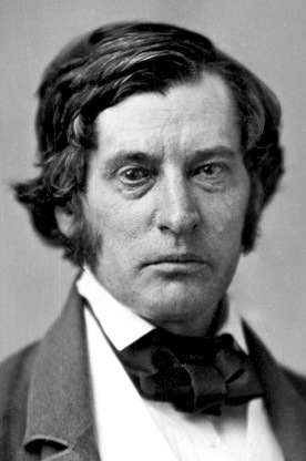
Charles Sumner in 1855 (Wikimedia Images)
A political opponent of western Democrats like Cass, Charles Sumner has gone down in history as the only man to be nearly beaten to death on the floor of the United States senate. Less than a year before Rep. Preston Brooks of South Carolina would attack him with a cane, sending the country hurtling ever-faster toward civil war, the Massachusetts senator visited La Pointe to watch the annuity payment. By 1855, Sumner already had a reputation as a staunch abolitionist, and he even wrote a letter to the Anti-Slavery Reporter while on board the North Star. Aside from a handful of like-minded native New Englanders like Edmund Ely and Leonard Wheeler, Sumner was not in a part of the country where most voters shared his views (the full-blood and most mix-blood Ojibwe were not considered citizens and therefore ineligible to vote). The Lake Superior country was overwhelmingly Democratic, and the Superior Chronicle praised the “popular sovereignty” views of Stephen Douglas in the midst of the violence following the Kansas-Nebraska Act. Sumner, whose caning resulted from his fierce criticism of popular sovereignty, was among those “radical Bostonians” the Chronicle warned its readers about. However, the newspaper was kind and uncritical when the senator appeared in its city:
Senator Sumner at Superior and La Pointe.: In our last number we neglected to announce the visit of Hon. Charles Sumner, Bishop McClosky, and other distinguished persons to Superior. They came by the North Star, and staying but a few hours, had merely time to hastily view our thriving town. They expressed gratfication at its admirable location and rapidity of its growth.
At La Pointe, the heat stopped to allow the passengers an opportunity to see that pretty village and the large number of Indians and others congregating there to the last great payment at this station of the Lake Superior Chippewas. Here Mr. Sumner was the guest of the reverend Catholic missionary, whose successful endeavors to gratify the numerous visitors at La Pointe we have frequently heard commended.
Superior Chronicle, August 14, 1855

Jesse D. Bright (Wikimedia Images)
Staying a little longer at Superior, another U.S. senator, Jesse Bright the President pro tempore Indiana, also appeared on Lake Superior in the summer of 1855. For Bright, however, this was more than a pleasure excursion. He had a chance to make real money in the real estate boom of the 1850s. Superior, at the head of the lake with ship traffic through the Soo, and military road and potential railroad connection to St. Paul, looked poised to be the next great gateway to the west. He invested and apparently lost big when the Great Lakes real-estate boom busted in the Panic of 1857.
Bright would go on to be a Southern sympathizer and a “Copperhead” during the Civil War and was the only northerner to be expelled from the Senate for supporting the Confederacy. In 1855, he was already a controversial figure in the partisan (Democrat, Whig, Know-Nothing) newspapers:
The Buffalo Commercial, upon the authority of the Cincinnati Gazette, states “that Mr. Bright, of Indiana, President of the Senate, pro tem lately made a Sunday speech, an hour and a half long to the people of a town on Lake Superior, and the passengers of the steamer in which he was travelling. He discoursed most eloquently on the virtues and glories of modern Democracy, whose greatest exemplar, he said, was the administration of Franklin Pierce.” The Know Nothing press, of which the Commercial and the Gazette are leading journals, must be rather hard up for material, when recourse to such misrepresentation as the above becomes necessary…
…The speaker did not allude to politics, and did not speak over ten minutes.
And out of this mole hill the Commercial manufactures a mountain of speculation, headed “Jesse D. Bright–The Presidency.” –Sandusky Mirror.
Fort Wayne [IN] Sentinel, September 5, 1855

Promoters & Proprietors of Old Superior: (Clockwise from upper left) U.S. Senator W[illiam]. A. Richardson, Sen. R[obert] M. T. Hunter, Sen. Jesse Bright, Sen. John C. Breckinridge, Benjamin Brunson, Col. John W. Fourney, Henry M. Rice (Flower, Frank A. Report of the City Statistician [1890] Digitized by Google Books)

John C. Breckinridge (Wikimedia Images)
It may also be uncomfortable for the modern northern reader to see how cozy the politicians of our area were with unabashedly pro-slavery Democrats and future Confederates. The biggest name among these Lake Superior investors and 1855 visitors would be John C. Breckinridge. Breckinridge, coming off a stint as U.S. Representative from Kentucky, would go on to be Vice President of the United States under James Buchanan, and Secretary of War for the Confederacy. However, he is most famous for finishing second to Abraham Lincoln in the pivotal presidential election of 1860. Chequamegon Bay residents will probably find another investment of the future vice-president more interesting even than the Superior scheme:
A PLEASANT SUMMER RESIDENCE–The senior editor of the Chicago Press writes from Lake Superior:
Basswood Island, one of the group of Apostle Island has been entered by Mr. Breckinridge of Kentucky, who, I am told, contemplates the erection of a summer residence upon it. We landed at this Island for wood. There is deep water up to its base, and our steamer lay close alongside the rocky shore as though it had been a pier erected for the purpose. There is deep water, I am told, in the channels between most of the Islands of the group furnished an excellent shelter for vessels in tempestuous weather.
[Milwaukee] Weekly Wisconsin, August 15, 1855
Hon J. C. Breckenridge, of Kentucky, has purchased Basswood Island, one of the group of Apostle Islands, in Lake Superior, and intends erecting a summer residence thereon.
Boston Post, August 23, 1855

Captain John Wilson (Frank Leslie’s Illustrated)
The Whig/Free Soil press’ condemnation of Senator Bright for allegedly forgetting the Sabbath and to keep it holy may remind the Chequamegon History reader of the A.B.C.F.M missionaries’ obsession with that particular commandment in their efforts among the Ojibwe people. However, it seems to be one of those features of 19th-Century America that was fussed about more than it was actually observed.
A good example of this comes from Captain John Wilson, who led the steamer Illinois to La Pointe in the summer of 1855. He seems to have been one of those larger-than-life characters, and he is often mentioned in newspaper accounts from the various Great Lakes ships he commanded. Wilson died off the shore of Milwaukee in the sinking of the Lady Elgin, in 1860 along with over 300 passengers. “The Titanic of the Great Lakes,” as the disaster came to be known, is still the greatest loss of life in the history of the lakes (this article gives a good overview). Other than the North Star, the Lady Elgin, which began its runs to the “Upper Lake” in 1855, was probably the most famous steamer on Lake Superior before its sinking. Captain Wilson was afterwards praised for his character heroism during the ordeal, which was blamed on the captain of the schooner that collided with the Elgin.
Captain Wilson’s charisma shines through in the following 1855 Lake Superior account, but I’ll let the reader be the judge of his character:
A MAN FOR ALL OCCASIONS–TWO AMUSEMENTS–Capt Wilson, of the steamer Illinois, on the Upper Lakes is proverbially a man for all occasions and is equally at home in a horse-race or a dance. During a recent excursion of his beautiful boat to Lake Superior, he happened to arrive at a place on Sunday, where several tribes of Indians were soon to receive their annuity from the General Government and where a large number were already present. As soon as the breakfast table was cleared Capt. W. commenced arrangements for religious services in the ladies’ cabin, agreeably to the request of a preacher on board. Chairs and sofa were placed across the hall and the piano, with a large bible on it, represented a pulpit. The large bell of the boat was tolled, and in a short time quite a respectable congregation occupied the seats. As soon as service had fairly begun, the Captain came upon the forward deck where a number of gentlemen were enjoying their pipes and meerschaum, and thus addressed them.
Gentlemen–I come to let you know that meetin‘ is now going on in the aft cabin, where all of you in need of prayers and who wish to hear a good sermon had better retire. I would also state that in accordance with the desire of several passengers , I intend to get up an Indian foot race on shore for a barrel of flour.–You can make your own selection of the two amusements.”
The foot race did come off, and it was fortunate that all the lady passengers were at “meetin,” as one of the Indians who started with nothing on him but a calico shirt came in minus that! He won the flour, however. Good for you! —Spirit of the Times
[Milwaukee] Weekly Wisconsin, October 3, 1855

Joseph R. Williams (Wikimedia Images)
Finally, we get back to Joseph R. Williams. The reason so many stories like Captain Wilson’s made it into the papers that summer was that each of the steamboats seemed to be carrying one or more Midwestern newspaper editors. Williams, the editor of the Toledo Blade, arrived on the Planet in time to witness the La Pointe payment.
Williams would go on to become the first president of what would become Michigan State University and serve in multiple positions in the state government in Michigan. His letters and notes from Lake Superior turned into multiple articles that made their way back up to the Superior Chronicle. In a later post, I may transcribe his record of C. C. Trowbridge’s account of the 1820 Cass Expedition or his description of Superior, but in the name of brevity, I’ll limit this post to his a article on the payment itself:
From La Pointe–Indian Payment, etc.
The following interesting incidents of the recent meeting of Chippeways at La Pointe are taken from the letters of Mr. Williams, editor of the Toledo Blade. Mr. W. was among those who visited Lake Superior on the last excursion of the steamer Planet. In another portion of this week’s paper will be made an account of General Cass’ expedition to the Northwest, from the pen of the same gentleman. We commend it and the following extracts, to the perusal of our readers.
This is one of the old American Fur Company’s stations, a village such as formerly existed at Detroit and Mackinac. Indian huts with bark roofs, the long low warehouse, the half dressed and painted Indians, here and there a Frenchman speaking his mother tongue, his whole air indicating his lineage plainly that he was the descendant of an old voyager, revive the reflection of those days so graphically described by Washington Irving in his Astoria. La Pointe is upon an island, and the harbor gracefully curves around us from the north.
Here we find Colonel Manypenny, Commissioner of Indian Affairs; H. C. Gilbert, Indian Agent for Michigan; Hon. D. A. Noble and Hon. H. L. Stevens, late members of Congress, and other gentlemen, who are awaiting the Indian payment to take place the beginning of next month. Grace Greenwood, who came up on the Illinois a few days since is also excursioning here. The store houses are full of the goods provided for the payment, piles of [?] and provisions, [?], plows, spades, [?] carts, mattresses, bedsteads, blankets, clothing, and [?] a well [?] supply of such articles as are calculated to promote the comfort and civilization of the ill-fated remnant of the former lords of these [many] isles scattered around us, and [the] “forests primeval,” on either shore of this vast inland sea.
Colonel Manypenny deserves great credit for the [ind?bility] with which he has endeavoured to carry into wholesale effect the [?] method adopted of paying the Indians their annuities. Formerly, the unfortunate [race] were paid in specie, and close on the tract of the dispenser of the payment came a swarm of cormorant and heartless Indians traders, who, for whisky and trinkets, and inferior arms and implements, including perhaps blankets and some useful articles of dress, obtained the dollars as soon as they were paid. The Indian dances followed by wild drunken orgies, were a perpetual accompaniment. The Indian, besotted by liquor, parted with almost everything of value, and returned to his home and his hunting grounds, poor and in worse condition than he came. Many years since I attended a payment at Grand Rapids, Michigan, and it was a mournful spectacle. One hardly knew whether to pity the weakness of the victims or abhor the heartlessness of the destroyers most. As late as 1833 the last Indian payment was made on the Maumee in the immediate vicinity of Toledo, on the point below Manhattan. One Lloyd was Indian Agent in 1830. It is said that he purloined from each of the thousand dollar boxes paid the Indians one or two hundred dollars, and that during the night whites went around among the wigwams and cut off the portion of the dresses of the Indians in which the specie was tied up. But the picture before us is relieved of features so disgraceful and disgusting. We saw no drunken Indian on shore. Indeed several of the Caucasian lords of these fading tribes, whom we had on board, might have taken a useful lesson in sobriety from the red men. The traders however are here. They mutter curses upon Colonel Manypenny, because he does not wink at their robberies. It is supposed abundance of whisky is concealed on the island, which will be unwrapped and sold, to besot the Indians, as soon at the valuables are distributed among them.
***
On his arrival here, the Indians proposed a dance. As dances end in Bacchanalian revels, the colonel has set his face against them. Enlivened and excited, however, by our band of music, the Indians could resist no longer. A dozen or more emerged from their cabins, bearing before them their war flag, which was a staff with a fringe of long feathers extending its length, and with bells attached to it, and engaged in a war dance. Their bodies were nearly naked and painted. The dance was a pantomimic description of war scenes. The leading brave struck the flagstaff to stop the dance, and made a speech describing how he had, less than thirty days ago, killed and scalped a Sioux, and he held up in his clenched fist, in triumph before us, the almost yet reeking scalp of his victim. His speech was accompanied by vigorous and appropriate [motion]. It was the imprompt and natural movement of body, [hands], and features from this brief specimen, it was easy enough to imagine that the Indian is often eloquent. This small band of dancers were splendid physical specimens of men, and the dance was real exultation over a late actual achievement. The Chippeways–and they are all Chippeways in these regions–maintain a traditional hostility to the Sioux, and are rarely at peace. It was only a few months since a band of Chippeways pioneered down into the village of St. Paul, and killed a Sioux woman trading in a store. Before the witnesses had recovered from the terror excited, the band had fled as rapidly as they appeared. The Sioux remain on the lands beyond, and the Chippeways this side of the Mississippi.
After the war dance was finished, they danced a beggar’s dance, the purport of which was that they wanted three beeves of Colonel Manypenny. At its close, the brave presented a pipe to Captain Ward, who smoked it in a token of amity. He then forced through the surrounding crowd, and sought Colonel M., who stood at a distance. The Colonel rejected the proffered pipe. His acceptance would have been a sanction of the dances he disapproved, and a concession of the three beeves. The Chief returned to the ring, and made a brief vehement speech, evidently a concentration of indignant scorn. Mrs. A., of Monroe, Michigan, an educated lady of Indian blood, informed me that it was full of defiance, bitterness and mortification.
******
In speaking of the Indians assembled at the payment in my last, I said they were a motley crew, and indeed they are. The braves, engaged in the dances described, were fine specimens of manhood. Their erect forms, developed chests, and symmetry, and general health, as developed in every muscle and feature, illustrate the perfection to which physical man is brought in savage life. But in sad contrast, we see around us pitiable specimens of humanity, crouching, lazy, filthy, besotted beings, who possess all the vices of both the white and the red races, and none of the virtues of either.
Canoes are marshalled along the beach, which have wafted here the tenants of both shores of Superior. Indians have dotted their clusters of wigwams over the vicinity, and seem to have brought along all their aged and infirm as well as infants.
I think one Indian woman here is the oldest human being I ever saw. The deep furrows, the folds of skin which have lost almost the appearance of vitality, so withered and dead as to resemble gutta percha, eye sight lost, hearing gone, no sense left except touch, which was indicated by the avidity with which she seized small pieces of money thrown into her lap, all these proofs convinced me that she was older by ten or fifteen years than any person I ever saw. A son and daughter were near her, apparently kind and affectionate, and proud to protect her, who themselves, were verging upon old age, an illustrative example of these [?ate] savages, to unnatural whites of whom melancholy tales of ingratitude are told. Even her children could not tell her age. All they could say was that she was “the oldest Indian.” Old Buffalo, the Chief, who was ninety years old, looked like a young man compared with her.
Nothing more surprised our party than the great proportion of their children, of all sizes, and I may add, shades of color, for the infusion of French blood from a long series of successive intermarriages, is found in every tribe. Infants fastened on boards, with the children and youth under sixteen, outnumber the adults. The children are all plump, all have rounded and full muscles, all good chests, thus showing that their life, vicious as it is, is more favorable to health and development, in consequence of their freedom of motion, perpetual exercise in the open air. Their gregariousness, flocking together where impulse carried them, as self reliant as their parents who seemed to allow them perfect freedom, even though strangers were so numerous among them, bore a pleasing, and to us instructive contrast to the entire and melancholy helplessness to which white children, especially in cities, are doomed.
Many of the Indians wore a feather or feathers in their cap, indicating the number of Sioux they had scalped. One displayed six feathers. He told us that he had in battle killed two, and taken the scalps of four others, killed by unknown hands of his band. The last victim he had slain but a month ago. One erect youth, of not more than eighteen, with a fresh and handsome face, bore proudly a single feather as a token of his early prowess. One man, in answer to the question, whether he had ever taken a scalp, replied gravely, without a smile, that he had not, and was of no more account that a woman in his tribe. An illustration of their generosity and savage ferocity is afforded by a sub-Chief who had an interview with Mr. Gilbert, the Indian Agent, a few days since. He presented Mr. G. an elegant cloak, made entirely of beaver skins, in expectation of nothing but a large medal in return. He was intent in speech, and animated and pleasant in address. No trace of savage ferocity lingered in his face. Yet it was stated that this man had actually killed and eaten his own child.
Sometimes their earnings if economically used would afford them a comfortable subsistence. The whites, even in their ordinary trade have practiced habitually heartless extortion. When Gov. Cass’s expedition visited this country in 1820, the Indians were in the habit of paying the traders a beaver skin, worth sixteen dollars, for a gill of powder; the same for a shirt; the same for thirty balls; and three beaver skins for a single blanket. I inquired of the Chief, Old Buffalo, what was the highest price he had ever paid for tobacco. He replied that they formerly made purchases of the Hudson Bay Company, tobacco was coiled up in ropes of about three quarters of an inch in diameter, and that he had paid ten beaver skins for a fathom, or at least ten dollars for a foot in length. But when the poor creatures became maniacs or idiots from drink, no possession was so prized that they would not part with it for a single cup of fire water. That the trader availed himself of the imbecility he created, is acknowledged. A large share of the boundless wealth of Mr. Astor was based on acquisitions, through his instruments and agents of this questionable and indeed diabolical character. Well might Burns exclaim in sorrow,
“Man’s inhumanity to man.
Makes countless thousands mourn.”
for whether among men and families of the same blood, or between civilized and savage men, either in peace or in the antagonism of war, the whole world and all time has teemed with sickening, heart-rending examples of its melancholy truth.
By chance we have been able to witness what can not be seen, a few years hence on this side of the “Father of waters,” or indeed on the continent. Here in our magnificent floating palace and the crowd of intellectual and cultivated people on board, surrounded by the refinements of life, we have the highest triumphs of civilization, side by side and in contrast with the rudest manifestations of primitive savage life.–An interesting episode in human affairs, though prompting [a] thousand sad reflections. The doom of entire extirpation of the red man seems surely and gradually to approach. The perpetual warfare among tribes on the extreme frontier annually declinates their most vigorous braves, and consequently it is manifest that among this tribe at least there were far more women than men between the ages of twenty and forty. Many perish from ignorance of the laws of nature, and many from excessive exposure and famine. Rapacity of the whites, and whiskey, finish the merciless work. They fade, they perish, as the grass of the prairies withers before the devouring element. The officers of our government, in their conference, have been accustomed to talk about the protection their Great Father vouchsafes to them, but it is the protection which the vulture affords the sparrow. Whatever may be the intentions of our professedly paternal government, no alternative seems to remain to the Indian, but submission to its crushing and onward march.

Dr. Bethune Duffield (Detroit–biographical sketches by Walter Buell [1886] Google Books)
1855 as a Turning Point: A plea to today’s Chequamegon Bay residents
Williams’ quote about the vulture and the sparrow, excerpted at the very top of this post, is about as succinct a statement about Manifest Destiny as I have ever read. If it weren’t surrounded by so many grossly-ignorant and disgusting statements about Ojibwe people, one might almost take it as sympathy for the Ojibwe cause. Still, the statement holds the key to our understanding of the story of 1855.
In the grand scheme of our region’s history, the payment was less significant than the treaty itself or the tragic removal politics of the early 1850s. Sure, it was the first payment under the final treaty and it featured the visit of Indian Affairs Commissioner George Manypenny to La Pointe, but ultimately it was largely like the rest of the 30-plus annuity payments that took place in our area in the middle of the 19th century. The death of Chief Buffalo in September 1855, and visit of Manypenny who shifted American Indian policy from removal to assimilation, represented both real and symbolic breaks with the past, but ultimately the great shift of 1855 is only one of tone.
Ultimately, however, this shift is only superficial and the reality of life for most Chequamegon residents didn’t change overnight in 1855. The careers of men like Blackbird, Vincent Roy Jr., Julius Austrian, Naaganab, and others show the artificiality of such a line. To them, the tourists on the Planet and North Star were probably just a distraction or curiosity.
Williams was wrong. The Ojibwe did not perish before the “devouring element,” and neither did that earlier history. Somehow, though, since then those of us who live in this area have allowed outsiders to write the story. Maybe it’s comfortable for those, like myself, of European ancestry to focus on shipwrecks and lighthouses rather than colonialism and dispossession, but in doing so we deny ourselves the most significant events of our area’s history and an understanding of its legacy on today.
By all means, learn the names of Grace Greenwood, John Breckinridge, and the Lady Elgin, but understand the fleeting impact of those names on our area’s history. Then, read up on Blackbird, Jechiikwii’o, Leonard Wheeler, Benjamin Armstrong and other players in 1855 politics who really did leave a lasting legacy.
Off my soapbox for now…
The bulk of this article comes from newspaper articles found on two digital archives. Access Newspaper Archive is available to Wisconsin library card holders through badgerlink.net. The Library of Congress Chronicling America site is free at http://chroniclingamerica.loc.gov/. Other sources are linked within the post.
CAUTION: This translation was made using Google Translate by someone who neither speaks nor reads German. It should not be considered accurate by scholarly standards.

Moritz Wagner (1813-1887) (Wikimedia Images)
Americans love travelogues. From de Tocqueville’s Democracy in America, to Twain’s Roughing It, to Steinbeck’s Travels with Charley, a few pages of a well-written travelogue by a random interloper can often help a reader picture a distant society more clearly than volumes of documents produced by actual members of the community. And while travel writers often misinterpret what they see, their works remain popular long into the future. When you think about it, this isn’t surprising. The genre is built on helping unfamiliar readers interpret a place that is different, whether by space or time, from the one they inhabit. The travel writer explains everything in a nice summary and doesn’t assume the reader knows the subject.
You can imagine, then, my excitement when I accidentally stumbled upon a largely-unknown and untranslated travelogue from 1852 that devotes several pages to to the greater Chequamegon region.
I was playing around on Google Books looking for variants of Chief Buffalo’s name from sources in the 1850s. Those of you who read regularly know that the 1850s were a decade of massive change in this area, and the subject of many of my posts. I was surprised to see one of the results come back in German. The passage clearly included the words Old Buffalo, Pezhickee, La Pointe, and Chippewa, but otherwise, nothing. I don’t speak any German, and I couldn’t decipher all the letters of the old German font.

Karl (Carl) Ritter von Scherzer (1821-1903) (Wikimedia Images)
The book was Reisen in Nordamerika in den Jahren 1852 und 1853 (Travels in North America in the years 1852 and 1853) by the Austrian travel writers Dr. Moritz Wagner and Dr. Carl Scherzer. These two men traveled throughout the world in the mid 19th-century and became well-known figures in Europe as writers, government officials, and scientists. In America, however, Reisen in Nordamerika never caught on. It rests in a handful of libraries, but as far as I can find, it has never been translated into English.
Chapter 21, From Ontonagon to the Mouth of the Bois-brule River, was the chapter I was most interested in. Over the course of a couple of weeks, I plugged paragraphs into Google Translate, about 50 pages worth.
Here is the result (with the caveat that it was e-translated, and I don’t actually know German). Normally I clog up my posts with analysis, but I prefer to let this one stand on its own. Enjoy:
XXI
From Ontonagon to the mouth of the Bois-brule River–Canoe ride to Magdalen Island–Porcupine Mountains–Camping in the open air–A dangerous canoe landing at night–A hospitable Jewish family–The island of La Pointe–The American Fur Company–The voyageurs or courriers de bois–Old Buffalo, the 90 year-old Chippewa chief–A schoolhouse and an examination–The Austrian Franciscan monk–Sunday mass and reflections on the Catholic missions–Continuing the journey by sail–Nous sommes degrades–A canoeman and apostle of temperance–Fond du lac–Sauvons-nous!
On September 15th, we were under a cloudless sky with the thermometer showing 37°F. In a birch canoe, we set out for Magdalene Island (La Pointe). Our intention was to drive up the great Lake Superior to its western end, then up the St. Louis and Savannah Rivers, to Sandy Lake on the eastern bank of the Mississippi River. Our crew consisted of a young Frenchman of noble birth and education and a captain of the U.S. Navy. Four French Canadians were the leaders of the canoes. Their trustworthy, cheerful, sprightly, and fearless natures carried us so bravely against the thundering waves, that they probably could have even rowed us across the river Styx.
Upon embarkation, an argument broke out between passengers and crew over the issue of overloading the boat. It was only conditioned to hold our many pieces of baggage and the provisions to be acquired along the way. However, our mercenary pilot produced several bags and packages, for which he could be well paid, by carrying them Madeline Island as freight.
Shortly after our exit, the weather hit us and a strong north wind obliged us to pull to shore and make Irish camp, after we had only covered four English miles to the Attacas (Cranberry) Rive,r one of the numerous mountain streams that pour into Lake Superior. We brought enough food from Ontonagon to provide for us for approximately 14 days of travel. The settlers of La Pointe, which is the last point on the lake where whites live, provided for themselves only scanty provisions. A heavy bag of ship’s biscuit was at the end of one canoe, and a second sack contained tea, sugar, flour, and some rice. A small basket contained our cooking and dining utensils.
The captain believed that all these supplies would be unecessary because the bush and fishing would provide us with the richest delicacies. But already in the next lunch hour, when we caught sight of no wild fowl, he said that we must prepare the rice. It was delicious with sugar. Dry wood was collected and a merry flickering fire prepared. An iron kettle hung from birch branches crossed akimbo, and the water soon boiled and evaporated. The sea air was fresh, and the sun shone brightly. The noise of the oncoming waves sounded like martial music to the unfinished ear, so we longed for the peaceful quiet lake. The shore was flat and sandy, but the main attraction of the scenery was in the gigantic forest trees and the richness of their leafy ornaments.
At a quarter to 3 o’clock, we left the bivouac as there was no more wind, and by 3 o’clock, with our camp still visible, the water became weaker and weaker and soon showed tree and cloud upon its smooth surface. We passed the Porcupine Mountains, a mountain range made of trapp geological formation. We observed that some years ago, a large number of inexperienced speculators sunk shafts and made a great number of investments in anticipation of a rich copper discovery. Now everything is destroyed and deserted and only the green arbor vitae remain on the steep trap rocks.
Our night was pretty and serene, so we went uninterrupted until 1 o’clock in the morning. Our experienced boatmen did not trust the deceptive smoothness of the lake, however, and they uttered repeated fears that storms would interrupt our trip. It happens quite often that people who travel in late autumn for pleasure or necessity from Ontonagon to Magdalene Island, 70 miles away, are by sea storms prevented from travelling that geographically-small route for as many as 6 or 8 days.
Used to the life of the Indians in the primeval forests, for whom even in places of civilization prefer the green carpet under the open sky to the soft rug and closed room, the elements could not dampen the emotion of the paddlers of the canoe or force out the pleasure of the chase.* But for Europeans, all sense of romantic adventure is gone when in such a forest for days without protection from the heavy rain and without shelter from the cold eeriness for his shivering limbs.
(*We were accompanied on our trip throughout the lakes of western Canada by half-Indians who had paternal European blood in their veins. Yet so often, a situation would allow us to spend a night inside rather than outdoors, but they always asked us to choose to Irish camp outside with the Indians, who lived at the various places. Although one spoke excellent English, and they were both drawn more to the great American race, they thought, felt, and spoke—Indian!)
It is amazing the carelessness with which the camp is set near the sparks of the crackling fire. An overwhelming calm is needed to prevent frequent accidents, or even loss of human life, from falling on the brands. As we were getting ready to continue our journey early in the morning, we found the front part of our tent riddled with a myriad of flickering sparks.
16 September (50° Fahrenheit)*) Black River, seven miles past Presque Isle. Gradually the shore area becomes rolling hills around Black River Mountain, which is about 100 feet in height. Frequently, immense masses of rock protrude along the banks and make a sudden landing impossible. This difficulty to reach shore, which can stretch for several miles long, is why a competent captain will only risk a daring canoe crossing on a fairly calm lake.
(*We checked the thermometer regularly every morning at 7 o’clock, and when travel conditions allowed it, at noon and evening.)
At Little Girl’s Point, a name linked to a romantic legend, we prepared lunch from the unfinished bread from the day before. We had rice, tea, and the remains of the bread we brought from a bakery in Ontonagon from our first days.
In the afternoon, we met at a distance a canoe with two Indians and a traveler going in an easterly direction. We got close enough to ask some short questions in telegraph style. We asked, “Where do you go? How is the water in the St. Louis and Savannah River?”
We were answered in the same brevity that they were from Crow Wing going to Ontonagon, and that the rivers were almost dried from a month-long lack of rain.
The last information was of utmost importance to us for it changed, all of a sudden, the fibers of our entire itinerary. With the state of the rivers, we would have to do most of the 300-mile long route on foot which neither the advanced season of the year, nor the sandy steppes invited. If we had been able to extend our trip, we could have visited Itasca Lake, the cradle of the Mississippi, where only a few historically-impressive researchers and travelers have passed near: Pike, Cass, Schoolcraft, Nicollet, and to our knowledge, no Austrian.
However, this was impossible considering our lack of necessary academic preparation and in consideration of the economy of our travel plan. We do not like the error, we would almost say vice, of so many travelers who rush in hasty discontent, supported by modern transport, through wonderful parts of creation without gaining any knowledge of the land’s physical history and the fate of its inhabitants.*
(*We were told here recently of such a German tourist who traveled through Mexico in only a fortnight– i.e. 6 days from Veracruz to the capital and 6 days back with only two days in the capital!)
While driving, the boatmen sang alternately. They were, for the most part, frivolous love songs and not of the least philological or ethnographic interest.
After 2 o’clock, we passed the rocks of the Montreal River. They run for about six miles with a long drag reaching up to an altitude of 100 feet. There are layers of shale and red sandstone, all of which run east to west. By weathering, they have obtained such a dyed-painting appearance, that you can see in their marbled colors something resembling a washed-out image.
The Montreal* is a major tributary of Lake Superior. About 300 steps up from where it empties into the lake, it forms a very pretty waterfall surrounded by an impressive pool. Rugged cliffs form the 80’ falls over a vertical sandstone layer and form a lovely valley. The width of the Montreal is 10’, and it also forms the border between the states of Michigan and Wisconsin.
(*Indian: Ka-wa’-si-gi-nong sepi, the white flowing falls.)
We stayed in this cute little bay for over an hour as our frail canoes had begun to take on a questionable amount of water as the result of some wicked stone wounds.
Up from Montreal River heading towards La Pointe, the earlier red sandstone formation starts again, and the rich shaded hills and rugged cliffs disappear suddenly. Around 6 o’clock, we rested for half an hour at the mouth of the Bad River of Lake Superior. We quickly prepared our evening snack as the possibility of reaching Magdalene Island that same night was still in contention.
Across from us, on the western shore of Bad River*, we saw Indians by a warm fire. One of the boatmen suspected they’d come back from catching fish, and he called in a loud voice across the river asking if they wanted to come over and sell us some. We took their response, and soon shy Indian women (squaws) appeared. Lacking a male, they dreaded to get involved in trading with Whites, and did not like the return we offered.
(*On Bad River, a Methodist Mission was founded in 1841. It consists of the missionary, his wife, and a female teacher. Their sphere of influence is limited to dispensing divine teaching only to those wandering tribes of Chippewa Indians that come here every year during the season of fishing, to divest the birch tree of its bark, and to build it into a shelter).
A part of our nightly trip was spent fantastically in blissful contemplation of the wonders above us and next to us. Night sent the cool fragrance of the forest to our lonely rocking boat, and the sky was studded with stars that sparkled through the green branches of the woods. Soon, luminous insects appeared on the tops of the trees in equally brilliant bouquets.
At 11 o’clock at night, we saw a magnificent aurora borealis, which left such a bright scent upon the dark blue sky. However, the theater soon changed scene, and a fierce south wind moved in incredibly fast. What had just been a quietly slumbering lake, as if inhabited by underwater ghosts, struck the alarm and suddenly tumultuous waves approached the boat. With the faster waves wanting to forestall the slower, a raging tumult arose resembling the dirt thrown up by great wagon wheels.
We were directly in the middle of that powerful watery surface, about one and one half miles from the mainland and from the nearest south bank of the island. It would have been of no advantage to reverse course as it required no more time to reach the island as to go back. At the outbreak of this dangerous storm, our boatmen were still determined to reach La Pointe.
But when several times the beating waves began to fill our boat from all sides with water, the situation became much more serious. As if to increase our misery, at almost the same moment a darkness concealed the sky and gloomy clouds veiled the stars and northern lights, and with them went our cheerful countenance.
Now singing, our boatmen spoke with anxious gestures and an unintelligible patois to our fellow traveler. The captain said jokingly, that they took counsel to see who should be thrown in the water first should the danger increase. We replied in a like manner that it was never our desire to be first and that we felt the captain should keep that honor. Fortunately, all our concern soon ended as we landed at La Pointe (Chegoimegon).
To be continued…
CAUTION: This translation was made using Google Translate by someone who neither speaks nor reads German. It should not be considered accurate by scholarly standards.
This post is on of several that seeks to determine how many images exist of Great Buffalo, the famous La Pointe Ojibwe chief who died in 1855. To learn why this is necessary, read this post introducing the Great Chief Buffalo Picture Search.
Today’s post looks at two paintings from the 1820s of Ojibwe men named Bizhiki (Buffalo). The originals are lost forever, but the images still exist in the lithographs that follow.

Pee-che-kir: A Chippewa Chief Lithograph from McKenney and Hall’s History of the Indian Tribes of North America based on destroyed original by Charles Bird King; 1824. (Wikimedia Images)

Pe-shick-ee: A Celebrated Chippeway Chief from the Aboriginal Port-Folio by James Otto Lewis. The original painting was done by Lewis at Prairie du Chien or Fond du Lac of Lake Superior in 1825 or 1826 (Wisconsin Historical Society).
1824 Delegation to Washington
Chronologically, the first known image to show an Ojibwe chief named Buffalo appeared in the mid-1820s at time when the Ojibwe and the United States government were still getting to know each other. Prior to the 1820s, the Americans viewed the Ojibwe as a large and powerful nation. They had an uncomfortably close history with the British, who were till lurking over the border in Canada, but they otherwise inhabited a remote country unfit for white settlement. To the Ojibwe, the Americans were chimookomaan, “long knives,” in reference to the swords carried by the military officers who were the first Americans to come into their country. It was one of these long knives, Thomas McKenney, who set in motion the gathering of hundreds of paintings of Indians. Two of these showed men named Buffalo (Bizhiki).

Charles Bird King: Self portrait 1815 (Wikimedia Images)
McKenney was appointed the first Superintendent of Indian Affairs in 1824. Indian Affairs was under the Department of War at that time, and McKenneyʼs men in the West were mostly soldiers. He, like many in his day, believed that the Indian nations of North America were destined for extinction within a matter of decades. To preserve a record of these peoples, he commissioned over 100 portraits of various Indian delegates who came to Washington from all over the U.S. states and territories. Most of the painting work fell to Charles Bird King, a skilled Washington portrait artist. Beginning in 1822, King painted Indian portraits for two decades. He would paint famous men like Black Hawk, Red Jacket, Joseph Brandt, and Major Ridge, but Kingʼs primary goal was not to record the stories of important individuals so much as it was to capture the look of a vanishing race.

No-tin copied from 1824 Charles Bird King original by Henry Inman. Noodin (Wind) was a prominent chief from the St. Croix country. King’s painting of Buffalo from St. Croix was probably also copied by Inman, but its location is unknown (Wikimedia Images).
In July of 1824, William Clark, the famous companion of Meriwether Lewis, brought a delegation of Sauks, Foxes, and Ioways to Washington to negotiate land cessions. Lawrence Taliaferro, the Indian agent at Fort St. Anthony (now Minneapolis), brought representatives of the Sioux, Menominee, and Ojibwe to observe the treaty process. The St. Croix chiefs Buffalo and Noodin (Wind) represented the Ojibwe.

Charles Bird King painted portraits of most of the Indians listed here in the the 1824 Washington group by Niles’ Weekly Register, July 31, 1824. (Google Books)
The St. Croix chiefs were treated well: taken to shows, and to visit the sights of the eastern cities. However, there was a more sinister motivation behind the governmentʼs actions. McKenney made sure the chiefs saw the size and scope of the U.S. Military facilities in Washington, the unspoken message being that resistance to American expansion was impossible. This message seems to have resonated with Buffalo and Noodin of St. Croix as it is referred to repeatedly in the official record. McKenney pointed Buffalo out as a witness to American power at the Treaty of Fond du Lac (1826). Schoolcraft and Allen mention Buffalo’s trip in their own ill-fated journey up the St. Croix in 1832 (see it in this post), and Noodin talks about the soldiers he saw in Washington in the treaty deliberations in the 1837 Treaty of St. Peters.
While in Washington, Buffalo, Noodin, and most of the other Indians in the group sat with King for portraits in oil. Buffalo was shown wearing a white shirt and cloak, holding a pipe, with his face painted red. The paintings were hung in the offices of the Department of War, and the chiefs returned to their villages.
James Otto Lewis
The following summer, St. Croix Buffalo and Noodin joined chiefs from villages throughout the Ojibwe country, as well as from the Sioux, Sac and Fox, Menominee, Ho-Chunk, Ioway, Ottawa, and Potawatomi at Prairie du Chien. The Americans had called them there to sign a treaty to establish firm borders between their nations. The stated goal was to end the wars between the Sioux and Ojibwe, but it also provided the government an opportunity to assert its authority over the country and to set the stage for future land cessions.
McKenney did not attend the Treaty of Prairie du Chien leaving it to Clark and Lewis Cass to act as commissioners. A quick scan of the Ojibwe signatories shows “Pee-see- ker or buffalo, St. Croix Band,” toward the bottom. Looking up to the third signature, we see “Gitspee Waskee, or le boeuf of la pointe lake Superior,” so both the St. Croix and La Pointe Buffalos were present among the dozens of signatures. One of the government witnesses listed was an artist from Philadelphia named James Otto Lewis. Over the several days of negotiation, Lewis painted scenes of the treaty grounds as well as portraits of various chiefs. These were sent back to Washington, some were copied and improved by King or other artists, and they were added to the collection of the War Department.
The following year, 1826, McKenney himself traveled to Fond du Lac at the western end of Lake Superior to make a new treaty with the Ojibwe concerning mineral exploration on the south shore. Lewis accompanied him and continued to create images. At some point in these two years, a Lewis portrait of an Ojibwe chief named Pe-schick-ee (Bizhiki) appeared in McKenneyʼs growing War Department collection.
Lithographs
By 1830, McKenney had been dismissed from his position and turned his attention to publishing a portfolio of lithographs from the paintings in the War Department collection. Hoping to cash in his own paintings by beating McKenney to the lithograph market, Lewis released The Aboriginal Port Folio in May of 1835. It included 72 color plates, one of which was Pe-schick-ee: A Celebrated Chippeway Chief.

Pencil sketch of Pee-che-kir by Charles Bird King. King made these sketches after his original paintings to assist in making copies. (Herman J. Viola, The Indian Legacy of Charles Bird King.)
Due to financial issues The History of the Indian Tribes of North America, by McKenney with James Hall, would not come out in full release until the mid 1840s. The three-volume work became a bestseller and included color plates of 120 Indians, 95 of which are accompanied by short biographies. Most of the lithographs were derived from works by King, but some were from Lewis and other artists. Kingʼs portrait of Pee-Che-Kir: A Chippewa Chief was included among them, unfortunately without a biography. However, we know its source as the painting of the St. Croix Buffalo in 1824. Noodin and several others from that delegation also made it into lithograph form. The original War Department paintings, including both Pee-Che-Kir and Pe-schick-ee were sent to the Smithsonian, where they were destroyed in a fire in 1858. Oil copies of some of the originals, including Henry Inmanʼs copy of Kingʼs portrait of Noodin, survive, but the lithographs remain the only known versions of the Buffalo portraits other than a pencil sketch of the head of Pee-Che-Kir done by King.
The man in the Lewis lithograph is difficult to identify. The only potential clue we get from the image itself is the title of “A Celebrated Chippeway Chief,” and information that it was painted at Prairie du Chien in 1825. To many, “celebrated” would indicate Buffalo from La Pointe, but in 1825, he was largely unknown to the Americans while the St. Croix Buffalo had been to Washington. In the 1820s, La Pointe Buffaloʼs stature was nowhere near what it would become. However, he was a noted speaker from a prominent family and his signature is featured prominently in the treaty. Any assumptions about which chief was more “celebrated” are difficult.
In dress and pose, the man painted by Lewis resembles the King portrait of St. Croix Buffalo. This has caused some to claim that the Lewis is simply the original version of the King. King did copy and improve several of Lewisʼ works, but the copies tended to preserve in some degree the grotesque, almost cartoonish, facial features that are characteristic of the self-taught Lewis (see this post for another Lewis portrait). The classically-trained King painted highly realistic faces, and side-by-side comparison of the lithographs shows very little facial resemblance between Kingʼs Pee-Che-Kir and Lewisʼ Pe-schick-ee.

Thomas L. McKenney painted in 1856 by Charles Loring Elliott (Wikimedia Images)
Of the 147 War Department Indian portraits cataloged by William J. Rhees of the Smithsonian prior to the fire, 26 are described as being painted by “King from Lewis,” all of which are from 1826 or after. Most of the rest are attributed solely to King. Almost all the members of the 1824 trip to Washington are represented in the catalog. “Pee-che-ker, Buffalo, Chief of the Chippeways.” does not have an artist listed, but Noodin and several of the others from the 1824 group are listed as King, and it is safe to assume Buffalo’s should be as well. The published lithograph of Pee-che-kir was attributed solely to King, and not “King from Lewis” as others are. This further suggests that the two Buffalo lithographs are separate portraits from separate sittings, and potentially of separate chiefs.
Even without all this evidence, we can be confident that the King is not a copy of the Lewis because the King portrait was painted in 1824, and the Lewis was painted no earlier than 1825. There is, however, some debate about when the Lewis was painted. From the historical record, we know that Lewis was present at both Prairie du Chien and Fond du Lac along with both the La Pointe Buffalo and the St. Croix Buffalo. When Pe- schick-ee was released, Lewis identified it as being painted at Prairie du Chien. However, the work has also been placed at Fond du Lac.
The modern identification of Pee-che-kir as a copy of Pe-schick-ee seems to have originated with the work of James D. Horan. In his 1972 book, The McKenney-Hall Portrait Gallery of American Indians, he reproduces all the images from History of the Indian Tribes, and adds his own analysis. On page 206, he describes the King portrait of Pee-che-kir with:
“Peechekir (or Peechekor, Buffalo) was “a solid, straight formed Indian,” Colonel McKenney recalled many years after the Fond du Lac treaty where he had met the chief. Apparently the Chippewa played a minor role at the council.
Original by James Otto Lewis, Fond du Lac council, 1826, later copied in Washington by Charles Bird King.”
Presumably, the original he refers to would be the Lewis portrait of Pe-schick-ee. However, Horanʼs statement that McKenney met St. Croix Buffalo at Fond du Lac is false. As we already know, the two men met in 1824 in Washington. It is puzzling how Horan did not know this considering he includes the following account on page 68:
The first Indian to step out of the closely packed lines of stone-faced red men made McKenney feel at home; it was a chief he had met a few years before in Washington. The Indian held up his hand in a sign of peace and called out:
“Washigton [sic]… Washington… McKenney shook hands with the chief and nodded to Lewis but the artist had already started to sketch.”
McKenneyʼs original account identifies this chief as none other than St. Croix Buffalo:
In half an hour after, another band came in who commenced, as did the others, by shaking hands, followed, of course, by smoking. In this second band I recognized Pee-che-kee, or rather he recognized me–a chief who had been at Washington, and whose likeness hangs in my office there. I noticed that his eye was upon me, and that he smiled, and was busily employed speaking to an Indian who sat beside him, and no doubt about me. His first word on coming up to speak to me was, “Washington”–pointing to the east. The substance of his address was, that he was glad to see me–he felt his heart jump when he first saw me–it made him think of Washington, of his great father, of the good living he had when he visited us–how kind we all were to him, and that he should never forget any of it.
From this, Horan should have known not only that the two men knew each other, but also that a portrait of the chief (Kingʼs) already was part of the War Department collection and therefore existed before the Lewis portrait. Horanʼs description of Lewis already beginning his sketch does not appear in McKenneyʼs account and seems to invented. This is not the only instance where Horan confuses facts or takes wide license with Ojibwe history. His statement quoted above that the Ojibwe “played a minor role” in the Treaty of Fond du Lac, when they were the only Indian nation present and greatly outnumbered the Americans, should disqualify Horan from being treated as any kind of authority on the topic. However, he is not the only one to place the Lewis portrait of Pe-schick-ee at Fond du Lac rather than Prairie du Chien.
Between, 1835 and 1838 Lewis released 80 lithographs, mostly of individual Indians, in a set of ten installments. He had intended to include an eleventh with biographies. However, a dispute with the publisher prevented the final installment from coming out immediately. His London edition, released in 1844 by another publisher, included a few short biographies but none for Pe-schick-ee. Most scholars assumed that he never released the promised eleventh installment. However, one copy of a self-published 1850 pamphlet donated by Lewisʼs grandson exists in the Free Library of Philadelphia. In it are the remaining biographies. Number 30 reads:
No. 30. Pe-shisk-Kee. A Chippewa warrior from Lake Huron, noted for his attachment to the British, with whom he always sided. At the treaty held at Fond du Lac, when the Council opened, he appeared with a British medal of George the III. on his breast, and carrying a British flag, which Gen. Cass, one of the Commissioners, promptly and indignantly placed under his feet, and pointing to the stars and stripes, floating above them, informed him that that was the only one permitted to wave there.
The Chief haughtily refused to participate in the business of the Council, until, by gifts, he became partly conciliated, when he joined in their deliberations. Painted at Fond du Lac, in 1826.
This new evidence further clouds the story. Initially, this description does not seem to fit what we know about either the La Pointe or the St. Croix Buffalo, as both were born near Lake Superior and lived in Wisconsin. Both men were also inclined to be friendly toward the American government. The St. Croix Buffalo had recently been to Washington, and the La Pointe Buffalo frequently spoke of his desire for good relations with the United States in later years. It is also troubling that Lewis contradicts his earlier identification of the location of the portrait at Prairie du Chien.
It is unlikely that Pe-schick-ee depicts a third chief given that no men named Buffalo other than the two mentioned signed the Treaty of Fond du Lac, and the far-eastern bands of Ojibwe from Lake Huron were not part of treaty councils with the Lake Superior bands. One can speculate that perhaps Lewis, writing 25 years after the original painting, mistook the story of Pe-schick-ee with that one of the many other chiefs he met in his travels, but there are some suggestions that it might, in fact, be La Pointe Buffalo.
The La Pointe Band traded with the British in the other side of Lake Superior for years after the War of 1812 supposedly confirmed Chequamegon as American territory. If you’ve read this post, you’ll know that Buffalo from La Pointe was a follower of Tenskwatawa, whose brother Tecumseh fought beside the British. On July 22, 1822, Schoolcraft writes:
At that place [Chequamegon] lived, in comparatively modern times, Wabojeeg and Andaigweos, and there still lives one of their descendants in Gitchee Waishkee, the Great First-born, or, as he is familiarly called, Pezhickee, or the Buffalo, a chief decorated with British insignia. His band is estimated at one hundred and eighteen souls, of whom thirty-four are adult males, forty-one females, and forty-three children.
It’s possible that it was La Pointe Buffalo with the British flag. Archival research into the Treaty of Fond du Lac could potentially clear this up. If I stumble across any, I’ll be sure to add it here. For now, we can’t say one way or the other which Buffalo is in the Lewis portrait.
The Verdict
Not Chief Buffalo from La Pointe: This is Chief Buffalo from St. Croix.
Inconclusive: This could be Buffalo from La Pointe or Buffalo from St. Croix.
Sources:
Horan, James David, and Thomas Loraine McKenney. The McKenney-Hall Portrait Gallery of American Indians. New York, NY: Bramhall House, 1986. Print.
KAPPLER’S INDIAN AFFAIRS: LAWS AND TREATIES. Ed. Charles J. Kappler. Oklahoma State University Library, n.d. Web. 21 June 2012. <http:// digital.library.okstate.edu/Kappler/>.
Lewis, James O., The Aboriginal Port-Folio: A Collection of Portraits of the Most Celebrated Chiefs of the North American Indians. Philadelphia: J.O. Lewis, 1835-1838. Print.
———– Catalogue of the Indian Gallery,. New York: J.O. Lewis, 1850. Print.
Loew, Patty. Indian Nations of Wisconsin: Histories of Endurance and Renewal.
Madison: Wisconsin Historical Society, 2001. Print.
McKenney, Thomas Loraine. Sketches of a Tour to the Lakes of the Character and Customs of the Chippeway Indians, and of Incidents Connected with the Treaty of Fond Du Lac. Baltimore: F. Lucas, Jun’r., 1827. Print.
McKenney, Thomas Loraine, and James Hall. Biographical Sketches and Anecdotes of Ninety-five of 120 Principal Chiefs from the Indian Tribes of North America. Washington: U.S. Dept. of the Interior, Bureau of Indian Affairs, 1967. Print.
Moore, Robert J. Native Americans: A Portrait : The Art and Travels of Charles Bird King, George Catlin, and Karl Bodmer. New York: Stewart, Tabori & Chang, 1997. Print.
Niles, Hezekiah, William O. Niles, Jeremiah Hughes, and George Beatty, eds. “Indians.” Niles’ Weekly Register [Baltimore] 31 July 1824, Miscellaneous sec.: 363. Print.
Rhees, William J. An Account of the Smithsonian Institution. Washington: T. McGill, 1859. Print.
Satz, Ronald N. Chippewa Treaty Rights: The Reserved Rights of Wisconsin’s Chippewa Indians in Historical Perspective. Madison, WI: Wisconsin Academy of Sciences, Arts and Letters, 1991. Print.
Schoolcraft, Henry Rowe, and Philip P. Mason. Expedition to Lake Itasca; the Discovery of the Source of the Mississippi,. [East Lansing]: Michigan State UP, 1958. Print.
Schoolcraft, Henry R. Personal Memoirs of a Residence of Thirty Years with the Indian Tribes on the American Frontiers: With Brief Notices of Passing Events, Facts, and Opinions, A.D. 1812 to A.D. 1842. Philadelphia: Lippincott, Grambo and, 1851. Print.
Viola, Herman J. The Indian Legacy of Charles Bird King. Washington: Smithsonian Institution, 1976. Print.
Warren, William W., and Theresa M. Schenck. History of the Ojibway People. St. Paul: Minnesota Historical Society, 2009. Print.
Special thanks to Theresa Schenck of the University of Wisconsin and Charles Lippert for helping me work through this information, and to Michael Edmonds of the Wisconsin Historical Society, and Alice Cornell (formerly of the University of Cincinnati) for tracking down the single copy of the unpublished James Otto Lewis catalog.
Note: This is the first of four posts about Lt. James Allen, his ten American soldiers and their experiences on the St. Croix and Brule rivers. They were sent from Sault Ste. Marie to accompany the 1832 expedition of Indian Agent Henry Schoolcraft to the source of the Mississippi River. Each of the posts will give some general information about the expedition and some pages from Allen’s journal. The journal picks up July 26, 1832, after the expedition has already reached the source, proceeded downriver to Fort Snelling (Minneapolis) and was on its way back to Lake Superior.
Henry Rowe Schoolcraft (1793-1864)
Although I’ve been aware of it for some time, and have used parts of it before, I only recently read Henry Schoolcraft’s, Narrative of an Expedition Through the Upper Mississippi to Itasca Lake: The Actual Source of this River from cover to cover. The book, first published in 1834, details Schoolcraft’s 1832 expedition through northern Wisconsin and Minnesota. As Indian agent at Sault Ste. Marie, he was officially sent by the Secretary of War, Lewis Cass, to investigate the ongoing warfare between the Ojibwe and Dakota Sioux. His personal goal, however, was to reach the source of the Mississippi River and be recognized as its discoverer.
Schoolcraft’s expedition included a doctor to administer smallpox vaccinations, an interpreter (Schoolcraft’s brother-in-law), and a protestant missionary. Having been west before, Schoolcraft knew what it would take to navigate the country. He hired several mix-blooded voyageurs who are hardly mentioned in the narrative, but who paddled the canoes, carried the portage loads, shot ducks, and did the other work along the way.

Ozhaawashkodewekwe (Susan Johnston) was the mother-in-law of Schoolcraft and the mother of expedition interpreter George Johnston. Born in the Chequamegon region, she is a towering figure in the history of Lake Superior during the late British and early American periods.
Attached the the expedition was Lt. James Allen and a detachment of ten soldiers, whose purpose was to demonstrate American power over the Ojibwe lands. The United States had claimed this land since the Treaty of Paris, but it was only after the War of 1812 that the British withdrew allowing American trading companies to move in. Still, by 1832 the American government had very little reach beyond its outposts at the Sault, Prairie du Chien, and Fort Snelling. The Ojibwe continued to trade with the British and war with the Dakota in opposition to their “Great Father” in Washington’s wishes.
This isn’t to say the Ojibwe were ignorant of the Americans and their military. By 1832, the Ojibwe were well aware of and concerned about the chimookomaanag (long knives) and what they were doing to other Indian nations to the south and east. However, the reality on the ground was that the Ojibwe were still in power in their lands.

Doc. 323, pg 55

Doc. 323, pg. 56

Doc. 323, pg. 57
Allen’s journal is part of Phillip P. Mason’s edition of Schoolcraft’s Expedition to Lake Itasca: The Discovery of the Source of the Mississippi (1958). However, these Google Books pages come from the original publication as part of the United States Congress Serial Set.
