Ishkigamizigedaa! Bad River Sugar Camps 1844
March 15, 2014

Indian Sugar Camp by Seth Eastman c.1850 (Minnesota Historical Society)
Since we’re into the middle of March 2014 and a couple of warm days have had people asking, “Is it too early to tap?” I thought it might be a good time to transcribe a document I’ve been hanging onto for a while.
170 years ago, that question would have been on everyone’s mind. The maple sugar season was perhaps the most joyous time of the year. The starving times of February and early March were on the way out, and food would be readily available again. Friends and relatives, separated during the winter hunts, might join back together in sugar camp, play music around the fire as the sap boiled, and catch up on the winter’s news.
Probably the only person around here who probably didn’t like the sugar season was the Rev. Sherman Hall. Hall, who ran the La Pointe mission and school, aimed to convert Madeline Island’s Native and non-Native inhabitants to Protestantism. To him, Christianity and “civilization” went hand and hand with hard labor and settling down in one place to farm the land. When, at this time of the year, all his students abandoned the Island with everyone else, for sugar camps at Bad River and elsewhere on the mainland and other islands, he saw it as an impediment to their progress as civilized Christians.
Rev. Leonard Wheeler, who joined Hall in 1841, shared many of his ethnocentric attitudes toward Ojibwe culture. However, over the next two decades Wheeler would show himself much more willing than Hall and other A.B.C.F.M. missionaries to meet Ojibwe people on their own cultural turf. It was Wheeler who ultimately relocated from La Pointe to Bad River, where most of the La Pointe Band now stayed, partly to avoid the missionaries, where he ultimately befriended some of the staunchest traditionalists among the Ojibwe leadership. And while he never came close to accepting the validity of Ojibwe religion and culture, he would go on to become a critical ally of the La Pointe Band during the Sandy Lake Tragedy and other attempted land grabs and broken Government promises of the 1850s and ’60s.
In 1844, however, Wheeler was still living on the island and still relatively new to the area. Coming from New England, he knew the process and language of making sugar–it’s remarkable how little the sugar-bush vocabulary has changed in the last 170 years–but he would see some unfamiliar practices as he followed the people of La Pointe to camp in Bad River. Although there is some condescending language in his written account, not all of his comparisons are unfavorable to his Ojibwe neighbors.
Of course, I may have a blind spot for Wheeler. Regular readers might not be surprised that I can identify with his scattered thoughts, run-on sentences, and irregular punctuation. Maybe for that reason, I thought this was a document that deserved to see the light of day. Enjoy:
Bad River Monday March 25, 1844
We are now comfortably quartered at the sugar camps, Myself, wife, son and Indian Boy. Here we have been just three weeks today.
I came myself the middle of the week previous and commenced building a log cabin to live in with the aid of two men , we succeeded in putting up a few logs and the week following our house was completed built of logs 12 by 18 feet long and 4 feet high in the walls, covered with cedar birch bark of most miserable quality so cracked as to let in the wind and rain in all parts of the roof. We lived in a lodge the first week till Saturday when we moved into our new house. Here we have, with the exception of a few very cold days, been quite comfortable. We brought some boards with us to make a floor–a part of this is covered with a piece of carpeting–we have a small cooking stove with which we have succeeded in warming our room very well. Our house we partitioned off putting the best of the bark over the best part we live in, the other part we use as a sort of storeroom and woodhouse.
We have had meetings during on the Sabbath and those who have been accustomed to meet with us have generally been present. We have had a public meeting in the foreroom at Roberts sugar bush lodge immediately after which my wife has had a meeting with the women or a sabbath school at our house. Thus far our people have seemed to keep up their interest in Religion.
They have thus far generally remembered the Sabbath and in this respect set a good example to their neighbors, who both (pagan) Indians and Catholics generally work upon the Sabbath as upon other days. If our being here can be the means of preventing these from declension in respect to religion and from falling into temptation, (especially) in respect to the Sabbath, an important end will be gained.
The sugar making season is a great temptation to them to break the sabbath. It is quite a test upon their faith to see their sap buckets running over with sap and they yet be restrained from gathering it out of respect to the sabbath, especially should their neighbors work in the same day. Yet they generally abstain from Labor on the Sabbath. In so doing however they are not often obliged to make much sacrifice. By gathering all the sap Saturday night, their sap buckets do not ordinarily make them fill in one day, and when the sap is gathered monday morning.
They do not in this respect suffer much loss. In other respects, they are called to make no more sacrifice by observing the sabbath than the people of N.E. do during the season of haying. We are now living more strictly in the Indian country among an Indian community than ever before. We are almost the only persons among a population of some 5 or 600 people who speak the English language. We have therefore a better opportunity to observe Indian manners and customs than heretofore, as well as to make proficiency in speaking the language.
Process of making sugar and skillful use of birch bark.
The process of making sugar from the (maple) sap is in general as that practiced elsewhere where this kind of sugar is make, and yet in some respects the modus operandi is very different. The sugar making season is the most an important event to the Indians every year. Every year about the middle of March the Indians, French and halfbreeds all leave the Islands for the sugar camps. As they move off in bodies from the La Pointe, sometimes in companies of 8, 10, 12 or 20 families, they make a very singular appearance.
Upon some pleasant morning about sunrise you will see these, by families, first perhaps a Frenchman with his horse team carrying his apuckuais for his lodge–provisions kettles, etc., and perhaps in addition some one or two of the [squaw?] helpers of his family. The next will be a dog train with two or three dogs with a similar load driven by some Indians. The next would be a similar train drawn by a man with a squaw pushing behind carrying a little child on her back and two or three little children trudging behind on foot. The next load in order might be a squaw drawn by dogs or a man upon a sled at each end. This forms about the variety that will be witnessed in the modes of conveyance. To see such a ([raucous?] company) [motley process?] moving off, and then listen to the Frenchmen whipping his horse, which from his hard fare is but poorly able to carry himself, and to hear the yelping of the dogs, the (crying of) the children, and the jabbering in french and Indian. And if you never saw the like before you have before you the loud and singular spectacle of the Indians going to the sugar bush.

“Frame of Lodge Used For Storage and Boiling Sap;” undated (Densmore Collection: Smithsonian)
One night they are obliged to camp out before they reach the place of making sugar. This however is counted no hardship the Indian carries his house with him. When they have made one days march it might when they come to a place where they wish to camp, all hands set to work to make to make a lodge. Some shovel away the snow another cut a few poles. Another cuts up some wood to make a fire. Another gets some pine, cedar or hemlock (boughs) to spread upon the ground for floor and carpet. By the time the snow is shoveled away the poles are ready, which the women set around in a circular form at the bottom–crossed at the top. These are covered with a few apuckuais, and while one or two are covering the putting up the house another is making a fire, & perhaps is spreading down the boughs. The blankets, provisions, etc. are then brought in the course of 20 or ½ an hour from the time they stop, the whole company are seated in their lodge around a comfortable fire, and if they are French men you will see them with their pipes in their mouths. After supper, when they have anything to eat, each one wraps himself in a blanket and is soon snoring asleep. The next day they are again under way and when they arrive at the sugar camp they live in their a lodge again till they have some time to build a more substantial (building) lodge for making sugar. A sugar camp is a large high lodge or a sort of a frame of poles covered with flagg and Birch apuckuais open at the top. In the center is a long fire with two rows of kettles suspended on wooden forks for boiling sap. As Robert (our hired man) sugar makes (the best kind of) sugar and does business upon rather a large scale in quite a systematic manner. I will describe his camp as a mode of procedure, as an illustration of the manner in which the best kind of sugar is made. His camp is some 25 or 30 feet square, made of a sort of frame of poles with a high roof open at the (top) the whole length coming down with in about (4 feet) of the ground. This frame is covered around the sides at the bottom with Flag apukuais. The outside and roof is covered with birch (bark) apukuais. Upon each side next to the wall are laid some raised poles, the whole length of the (lodge) wall. Upon these poles are laid some pine & cedar boughs. Upon these two platforms are places all the household furniture, bedding, etc. Here also they sleep at night. In the middle of the lodge is a long fire where he has two rows of kettles 16 in number for boiling sap. He has also a large trough, one end of it coming into the lodge holding several Barrels, as a sort of reservoir for sap, beside several barrels reserved for the same purpose. The sap when it is gathered is put into this trough and barrels, which are kept covered up to prevent the exposure of the sap to the wind and light and heat, as the sap when exposed sours very quick. For the same reason also when the sap and well the kettles are kept boiling night and day, as the sap kept in the best way will undergo some changes if it be not immediately boild. The sap after it is boild down to about the consistency of molases it is strained into a barrel through a wollen blanket. After standing 3 or 4 days to give it an opportunity to settle, some day, when the sap does not run very well, is then set aside for sugaring off. When two or 3 kettles are hung over the fire a small fire built directly under the bottom. A few quarts of molasses are then put into the kettles. When this is boiled enough to make sugar one kettle is taken off by Robert, by the side of which he sets down and begins to stir it with a small paddle stick. After stirring it a few moments it begins to grow all white, swells up with a peculiar tenacious kind of foam. Then it begins to grain and soon becomes hard like [?] Indian pudding. Then by a peculiar moulding for some time with a wooden large wooden spoon it becomes white as the nicest brown sugar and very clean, in this state, while it is yet warm, it is packed down into large birch bark mukoks made of holding from 50 to a hundred lbs.
 Makak: a semi-rigid or rigid container: a basket (especially one of birch bark), a box (Ojibwe People’s Dictionary) Photo: Densmore Collection; Smithsonian
Certainly no sugar can be more cleaner than that made here, though it is not all the sugar that is made as nice. The Indians do not stop for all this long process of making sugar. Some of (their) sorup does not pass through anything in the shape of a strainer–much less is it left to stand and settle after straining, but is boiled down immediately into sugar, sticks, soot, dirt and all. Sometimes they strain their sorup through the meshes of their snow shoe, which is but little better than it would be to strain it through a ladder. Their sugar of course has rather a darker hue. The season for making sugar is the most industrious season in the whole year. If the season be favorable, every man wom and child is set to work. And the departments of labor are so various that every able bodied person can find something to do.
 The British missionary John Williams describes the coconut on page 493 of his A Narrative of Missionary Enterprises in the South Sea Islands (1837). (Wikimedia Commons)
In the business of making sugar also we have a striking illustration of the skillful and varied use the Indians make of birch bark. A few years since I was forcibly struck, in reading Williams missionary enterprises of the South Seas, with some annals of his in regard to the use of the cocoanut tree illustrated of the goodness and wisdom of God in so wonderfully providing for their condition and wants (of men). His remarks as near as I can recollect are in substance as follows. The cocoanut tree furnishes the native with timber to make his house, canoe, his fire and in short for most of the purposes for which they want wood. The fruit furnishes his most substantial article of food, and what is still more remarkable as illustrating that principle of compensation by which the Lord in his good providence suplies the want of one blessing by the bestowment of another to take its place. On the low islands their are no springs of water to supply the place of this. The native has but to climb the cocoanut tree growing near his door and pluckes the fruit where in each shall he find from ¼ a pint to a kind of a most agreeable drink to slake his thirst. His tree bearing fruit every month in year, fresh springs of water are supplied the growing upon the trees before his own door. Although the birch bark does not supply the same wants throughout to the Indian, yet they supply wants as numerous and in some respects nearly as important to their mode of living as does the cocoanut to the Inhabitants of the South Sea Islands.
 Biskitenaagan: a sap bucket of folded birch bark (Ojibwe People’s Dictionary) Photo: Waugh Collection; Smithsonian
It is with the bark he covers his house. With this bark he makes his canoe. What could the Indian do without his wigwam and his canoe? The first use (of the bark) we notice in the sugar making business what is called the piscatanagun, or vessel for catching sap in. The Indian is not to the expence or trouble of making troughs or procuring buckets to catch the sap at the trees. A piece of birch bark some 14 inches wide and 18 or 20 inches wide in the shape of a pane of glass by a peculiar fold at each end kept in place by a stitch of bark string makes a vessel for catching sap called a piskitenagun. These are light, cheap, easily made and with careful usage will last several years. When I first saw these vessels, it struck me as being the most skillful use of the bark I had seen. It contrasted so beautifully with the clumsy trough or the more expensive bucket I had seen used in N.E. This bark is not only used to catch the sap in but also to carry it in to the sugar camps, a substitute for pails, though lighter and much more convenient for this purpose than a pail.
 “Chippewa Bucket and Trays Made of Birch Bark” (
In making a sap bucket bark of a more substantial kind is used than for the piskatanaguns. They made large at the bottom small at the top, to prevent the sap from spilling out by the motion of carrying. They are sewed up with bark the seams gummed and a hoop about the top to keep them in shape and a lid. But we are not yet done with the bark at the sugar bush. In boiling sap in the evening thin strips are rolled tight together, which is a good substitute for a candle. Every once in a little while the matron of the lodge may be seen with her little torch in hand walking around the fire taking a survey of her kettles. Lastly when the sugar is made it is finally deposited in large firmly wrought mukuks, which are made of bark. This however is not the end of bark. It is used for a variety of other purposes. Besides being a substitute in many cases for plates, [bearers & etc.?], it is upon birch bark that the most important events in history are recorded–National records–songs, & etc. are written in hieroglific characters (upon this article) and carefully preserved by many of the Indians.
And finally the most surprising use of bark of which I have heard or could conceive of, is before the acquaintance of the Indians with the whites, the bark was used as a substitute for kettles in cooking, not exactly for bake kettles but for (kettles for) boiling fish, potatoes, & etc. This fact we have from undoubted authority. Some of the Indians now living have used it for this purpose themselves, and many of them say their fathers tell them it was used by their ancestors before iron kettles were obtained from the whites. One kettle of bark however would not answer but for a single use.
Transcription note: Spelling and grammatical errors have been maintained except where ambiguous in the original text. Original struck out text has been maintained, when legible, and inserted text is shown in parentheses. Brackets indicate illegible or ambiguous text and are not part of the original nor are the bolded words and phrases, which were added to draw attention to the sidebars.
The original document is held by the Wisconsin Historical Society in the Wheeler Family Papers at the Northern Great Lakes Visitor Center in Ashland.
CAUTION: This translation was made using Google Translate by someone who neither speaks nor reads German. It should not be considered accurate by scholarly standards.
When we last left Moritz Wagner and Carl Scherzer, the two Austrian adventurers who traveled across Lake Superior in 1852, they had avoided certain death when caught in a storm halfway through the crossing between Bad River and La Pointe. In this post, we find them on Madeline Island in the wee hours of the morning, looking for a place to stay.
In the three days they spent in La Pointe, they produced a description of the island as colorful as any I’ve come across. Enjoy:

A View of La Pointe from Report of a Geological Survey of Wisconsin, Iowas, and Minnesota (1852) by David Dale Owen (Digitized by Google Books)
XXI
From Ontonagon to the mouth of the Bois-brule River–Canoe ride to Magdalen Island–Porcupine Mountains–Camping in the open air–A dangerous canoe landing at night–A hospitable Jewish family–The island of La Pointe–The American Fur Company–The voyageurs or courriers de bois–Old Buffalo, the 90 year-old Chippewa chief–A schoolhouse and an examination–The Austrian Franciscan monk–Sunday mass and reflections on the Catholic missions–Continuing the journey by sail–Nous sommes degrades–A canoeman and apostle of temperance–Fond du lac–Sauvons-nous!
It was 1 o’clock in the morning, and the whole settlement was in a deep sleep. We were at a loss as to which door to knock at. Among 200 Indians, only a few white families live there. One of the boatmen gave us a name, with which we found Mr. Austrian (a name meaning Oestreicher) a descendent of the Mosaic.
We knocked confidently by rattling at the window showing the distinguishing hemp of Austrian. We have always had a favorable bias for our Jewish countrymen in this nation. They have brought over so many ancient patriarchal customs of antiquity unadulterated, faithful, and pure in their sympathetic breasts. Here the noble manners of hospitality sweep away the cold breath of selfishness found among the Americans. The Jews are always ready to welcome strangers and donate a warm and magnanimous hand with every occasion.
They opened and the young doorman yelled out to the person in the next room, “Joe, steh auf, Leut from below, sind da!” and because it could not be doubted that we were, “One of our people!” We were then bombarded with all the tastes of the kosher delicatessen: belek, kugel, kindeln, and other tidbits of the Jewish frying pan. We were offered a nice, clean room and did not suspect that the close Yom Kippur (Jewish fast day) should frustrate our feast.
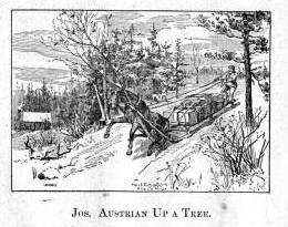
Jewish-immigrant brothers, Julius and Joseph Austrian, were prominent La Pointe residents at this time. This image depicts an incident from Benjamin Armstrong’s Early Life Among the Indians (Engraving by Marr & Richards Co.).
17 September, early, 61° Fahr. The actual owner of the home was absent. However, his younger brother received us with all the warmth of a Bayreuth Jew. He had only been in the country a short time, and spoke English with a Spanish-sounding accent as he called to us in the room, “Waken sie!” He showed us a pair of Indian snowshoes, and asked, “Haben sie snow shoes noch nie geused?*” He finally told of the fish trade in the same mixed gibberish, “Below werden die Fische umgepakt, inspected, und dann weider vereignepakt again.”
(*German immigrants all have a peculiar manner of acquiring the English language. As they hear a strange new name, they mix it together immediately with the words of their native language, without regard for how the expression works in English. A carpenter told us, “Wenn sie ein loghouse bauen wollen un dasselbe inwendig geplastered und von außen geclapboarded wird, so wird es 700 dollars kosten!”
In Pennsylvania, all counties speak an unintelligible German-English slang. It may be that after a few generations, a whole new language is emerging. So, some German immigrants are a tragic example of how one can forget his native language without having to learn another language as a substitute.)
La Pointe is the largest of several islands known under the collective name of Isles des Apotres. It has an unusual history. One of the earliest points on Lake Superior where men of faith planted the cross of salvation in 1665, it wasn’t until a century later that the progress of civilization began to push the two and four-legged forest dwellers further and further west . For several years it was the home depot (post) of the Fur Trading Company. This trading company was founded in 1808 by John Jacob Astor as the American Fur Trading Company, by an act of law of the State of New York. It granted exclusive right of trade and intercourse with the Indians, and in earlier times, provided an immense source of power and wealth. Currently, the business is divided between a Company of the West and the North West, of which the latter united with the Hudson’s Bay Company* and created unrestricted competition and limited the field of activity. The company of the west, currently under the leadership of J. Chouteau and Company, trades with the Indians of the Missouri and Mississippi. Its headquarters are at the upper Mississippi. The company owns 25 stations (trading posts) employing 200 voyageurs who take care of transporting commodities in the business season and bring the furs to the businesses located in St. Paul, Mendota, and Crow Wing in the Minnesota Territory.
(*[This footnote goes on for several pages on the history and structure of the Hudson Bay Company. As it interrupts the narrative, and can be found in other sources, I’ve omitted it.])
The different Indian tribes will kill the animals of the forest in the course of the year and then gather at certain points for the individual bands. Every year there is a caravan of agents (traders) of the fur company who obtain this rich quantity of valuable animal skins from the ignorant Indians for a lowly price of trade items.
This commercial agent will bring birch canoes full of presents across Lake Superior, and usually in 26 to 30 days will bring back the skins of bears, wolves, silver and other foxes, beavers, raccoon, martens, wolverine, otters, muskrats, weasels, and buffalos. Whether their fate is to be a winter covering for the delicate lady’s hands or the lining of a skirt in the princely salons is yet to be determined.
Next door, in perhaps richer numbers and selection, but certainly of far less value, are items of the clever broker. The eyes glare as he flaunts his manufactures. One sees, woolen blankets, cloth fabrics, firearms, ammunition, tin kettles, earrings, finger rings, brass buttons, breastplates, wampum, chopping knives, birch canoes, and mirrors. There is makeup of red, blue, black, and green color, but all the items together carry only one color, that of speculation and dizzying purpose.
Although the furs are barter items, they have an adopted value determined so that the price of the animal fur always corresponds with a certain number of exchanged wares. But the furs are usually valued very low and in contrast, the reverse items are priced very high. The total traffic area with the Indians in the West should produce 1 million dollars annually. Together, the furs are shipped, via New York, to London which is the main market for the American fur trade.
Since we did not visit these remote areas during the season of barter, we could not bear witness to this certainly most-interesting and instructive spectacle, but we cannot omit some words and impart some pressure as we become aware of the facts which throw a sad light on the business of the whites with the Indians. We believe it is the same, and more truthful, to be told as it is by Schoolcraft, the highly-respected American historian, on his travels among the tribes on Lake Superior.
A shotgun worth 10 guineas was sold by an agent to an Indian chief for 120 pounds of beaver skins, or 480 dollars of value. A caravan of 6 bales of barter commodities was traded for $2000. In Athabasca, 96 sacks of beaver skins weighing 8640 pounds brought back four dollars of value when their real worth was $34,560!
Another scholarly researcher, Coldon,writing in 1741 in the area of the Five Nations, describes how the whites in general and the traders in particular, create debts. The vice of drunkenness among the wild Indians occurs so frequently because the greed of the traders allows them to shrink to the lowest means and intentionally put the foolish aborigines in a state of intoxication causing an even more advantageous position for fraud. This evil passion has wreaked more havoc among the Indians than disease or war. It has destroyed more than instruction in Christianity could ever be capable of building up.
Among the Indian tribes there is a strongly-held opinion that if you murder a fur trader, he will retaliate by intentionally bringing back infected goods.* This belief probably arose from the sensitivity caused by the way the whiteskins associate with the redskins. They treat the actual natives of American soil as their subjects and servants, and consider it their privilege to satisfy their greed and passion and claim material and bodily impunity.**
(*[Here the authors insert an extensive footnote about smallpox infections in the Lake Superior region. As it disrupts the narrative and is information that can be found in Schoolcraft’s Narrative of an Expedition Through the Upper Mississippi River to Itasca Lake, I’ve omitted it here.])
(**Two residents of La Pointe told us how a former agent convinced several Indians and mix-bloods to entrust him with their savings due to them from the sale of the Indian country to the government. He used the advantage of his position to gain their trust and did not issue receipts for the borrowed. He had about $800 from everyone but when it was claimed, the fraudulent agent told them they would have to be content with repayment in commodities, flour, sausage, and potatoes, for which the he charged an exorbitant price. We started this narrative not wanting to believe it, but two good Catholics swore on the host. The agent has since left this island, to general contempt, taking the gold pieces of the Indians with him.)

The Voyageurs (1846) by Charles Deas (Wikimedia Images)
After this discussion of the of the rates of the American Fur Company and its agents, we want to add some details about the men whose labor and time exerted such a great influence on the fate and culture of the Indian tribes. We wish to add a few explanatory words about the sad presence on La Pointe of the voyageurs or courriers du bois.
This peculiar class of people, which is like a vein of metal that suddenly disappears within the bedrock and reappears many hundreds of miles away under the same geological conditions, their light reaches the borders of the eastern Canadas. The British people, with their religion and customs, reappeared on the shores of these northern lakes only in 1808 with the Fur Company. For labor they drew on those who could carry their wares across the lakes and communicate with the Indians.
Many young men of adventurous natures left the old wide streets of Montreal and moved into the trackless primeval forests of the West. Young and strong as laborers, they soon started to adopt the lifestyle and language of the aborigines. They married with the Indians and inhabit small settlements scattered throughout those mighty lands which begin at Mackinow Island and come up the upper lake to the region of Minnesota. They almost all speak the Canadian patois along with the language of the Chippewas, the tribe with which they came into kinship. We found only a few, even among the younger generation, who understood English.
Since then, every day the population of the otherwise deserted shore of Lake Superior increases with the discovery of copper mines. The animals driven away by the whirlwind of civilization toward the west, attract the Indians with their sensitive guns, leaving La Pointe, abandoned by the Company for their headquarters at St. Paul in Minnesota. Most voyageurs left the island, having seen their business in ruins and lacking their former importance. Just a few families remain here, making a meager livelihood of hunting, fishing, and the occasional convoy of a few travelers led by business, science, or love of nature who purchase their limited resources.*
(*Except for us, this year they had only two travelers visit this area for scientific interest. The scarcity of this type of tourist seems to be the reason why the price the voyageurs and their companions ask is high. We paid all our leaders one and one half dollars a day and just as many for the days necessary for their return. The voyageurs are democratic and truly similar to those Alpine villagers who charged the emperor two Louis d’or for a breakfast of two eggs.)
A devout Franciscan friar, the family of a Methodist preacher, a school teacher, and a skilled tradesman, together with some old canoe houses, remains of the once large voyageur legion, make up the small numbers of the white population.
The island is 15 miles long, 5.6 miles wide, and has 30 miles in circumference. The main formation is sandstone and red clay. Vegetation proliferates in spruce, pine, cedar, birch, tamarack (Larix americana), etc. The oval horseshoe shape of the island makes it one of the best ports of the entirety of Lake Superior, and this, despite current unemployment, promises hope for a comfortable future.
Add to that, the infinite abundance of fish on their shores. Delicious, but only edible in the spring, are the Siscawit (Salmo siscowet), and the trout (Salmo amethystus). The whitefish (Coregonus albus) are available in uncommon quantities. The most successful fishmonger here sent during the past years, 300 barrels of various species of fish, each 200 pounds, to the markets of Cleveland and Detroit.

The Siscowet, or Fat Trout, is a subspecies of Lake Trout (Drawn by David Starr Jordan, and Barton Warren Evermann, 1911; Digitized by University of Washington)
At the invitation of the zealous schoolteacher*, we toured the schoolhouse. Here we met Old Buffalo (Chi Waishki or Pezhickee), the 90-year-old hereditary chief of the Chippewa band. He was wrapped in a blue striped shirt and a wool blanket. He carried a royal scepter made from a broken wooden base of a bed as a symbol of his authority. He was looking for some glue to repair a garment for a young Indian. We find it necessary here to mention that of the many Chippewas on this island, very few are full-blood Indians. Having crossed frequently with the European race, and through the efforts of Christian missionaries, they have adopted the habits of civilization. They inhabit the abandoned wooden shacks of the Fur Company, and are even given to industrial employment.
(*Mr. Pulcifer, the schoolmaster is a highly-educated teacher. He gives the Sabbath service in the absence of the Methodist preacher. The Methodist mission on the island of La Pointe was founded in 1831).
The Indian chief, worthy by his age, heredity, and his imposing figure, told us he was born near the island and left the area only once to travel in the matters of his tribe to the Great Father* in Washington. His stay was accompanied by many consoling words but little actual success. Since then, he’s been back to the chase. One winter, he brought in 150 fox skins. Despite this wealth of skins in a game-rich area, he is now poor. Here we have the hereditary Chippewa chief, whose generations (totem) are carved in the ancient birch bark,** giving us profuse thanks for just a modest silver coin and a piece of dry cloth. What time can bring to a ruler!
(*”Great Father” is what the Indians call the President and other agents of the United States government.)
(**Almost all Indian tribes have the custom of preserving their lineage from oblivion by carving characters, that correspond to the names of their tribe, on trees, canoes, weapons and everywhere else.
Strangely, we later learned that the majestic Old Buffalo was violently opposed for years to the education and spiritual progress of the Indians. Probably, it’s because he suspected a better instructed generation would no longer obey. Presently, he tacitly accepts the existence of the school and even visits sometimes, where like ourselves, he has the opportunity to see the gains made in this school with its stubborn, fastidious look of an old German high council.)
Although made of simple planks, the school hall is clean and well-ventilated. The youth, consisting of 25 mix-blooded children, are instructed by the Methodist teachers in reading, writing, arithmetic, geography, and natural history. The teacher takes 6 to 8 children to the teacher’s desk and tells them to read their lessons or recite them from memory. Most often, there are questions which are subjected to discussion, questions that relate to the everyday world. This gives the youth the advantage of preparation for practical life.*
(*One of these practical textbooks is similar to Guide to Knowledge, a popular textbook in England: Conversations on common things by a teacher. Boston, Munroe and Francis. 1849.)
For example, a student may read a sentence in which the word “lead” occurs. This immediately gives rise to an instructive conversation about this noble metal, such as where lead is most found, what it is used for, the compounds in which it is used, etc. The youth, by learning this way about various natural phenomena, learns at the same time to know and admire the sources of a country’s wealth. It is an early and delicate way to teach the students the important parts of the geographical, physical, and political history of the country before their own history.

The front page of the Kladderadatsh, a German-languague satirical newspaper published in Berlin. Despite it’s popularity among the masses in Europe, I’m not sure the kids in La Pointe had subscriptions (Wikimedia Images).
At the conclusion of the lesson, the older children, by their own reflection but encouraged by their teacher, asked us several questions about European life: if many European children went to school, and what they learned there…
It was shamefully difficult answering these simple questions asked by the children.
We told these smart young half-Indians that here in Europe the same God lives and moves as in their hemisphere, and that His sun is the only true light that rises for the peoples of the East. We replied further that children learn a tremendous amount but usually know incredibly little, and finally, that the Berliner Kladderadatsch is the most widely read political journal. This last answer left the little indigene who asked the pointed questions bewildered and seemed to discourage the asking of any further information about Europe. At that point, the school meeting was cancelled to our great relief.
Another no-less worthy host received us with warm greetings of the heart. It was the worthy Franciscan monk, Father Scolla, from Rudolphswerth in Carinthia. We went to deliver the pleasure of a recommendation to our pious countryman. We knocked at the meager gate of the little boarded house that grew out from the rear part of the church. We are now almost ashamed of the worldly manner in which we approached, given the distinguished reception we received at the hands of such a pious priest.

Alternate translation of this passage found in History of the diocese of Sault Ste, Marie and Marquette (1906) by Antoine Ivan Rezek pg.367 (Digitized by Google Books)
Our traveling way of life often finds us witness to scenes of parting, separation, and reunion, but we have never seen any man become so pale, taken, and overcome with intimate emotion as this Franciscan when he learned through language and handshake that we were compatriots from the Imperial City.
We can reasonably account for this surprise in that almost 20 years had passed since the lone missionary had seen a countryman “of the Imperial City” and had been addressed in his language, and felt the warm shake of an Austrian hand. His whole religious intercourse with the faithful, be it preaching the gospel at the pulpit, forgiving sin in confessional, or donating food for the journey to the deathbed, happens in a foreign tongue, in French and Indian language.
What troubled us most about his monastic life was the poverty and helplessness with which this devout priest remains continually fights to preach the Way. The greater part of his church consists of converted Indians and mix-bloods, who all live in such poor circumstances that there is no thought of support for this priest. The maintenance costs for the church and its priests must therefore be restricted to those means which fall from the general missionary funds of the Catholic Church.
The quota, that makes its way to the Church of Our Lady of La Pointe, is extremely low, and sometimes isn’t received for so many years that one gets the impression that the bishop in Milwaukee has forgotten the lonely forests of Madeline Island, its Lady, and Father Scolla. The pious Franciscan, whose destitution has denied him any assistance in church and house, must therefore do as priests and lay ministers do. He decorates and adorns the high altar, paints the images of saints, rings the bell, and worries about the upkeep of his small house at the same time.

cntd. translation in Rezek pg.368
On the Sunday before we left, we attended the service. The small church was quite filled with Indian women, mix-bloods, and Canadian voyageurs. The women wore long cloth of dark green, blue, and black covering them from hips to head and wrapping them in one whole soft shape. The men were all dressed in European clothing. During the vicarious sacrifice of the mass, four half-Indians in white surplices sang the Latin text shouldering such edification that you would have sworn they understood every word.
The sermon was held in French, the most common language of the island, and it was appropriate for the comprehension of the people in the audience. In the afternoon, the tireless Franciscan monk preaches in Indian for his neophytes, which prevents age from weakening his intellectual ability to learn a foreign tongue.
Much more edification of the faithful would have prevailed if not for the wailing cries of the infants disturbed by the devotion, who were brought along on the backs of the countless “squaws.” But these grumpy little citizens of the world seemed to understand even less than the adult choir of the plot of the Latin score.

Fr. Otto Skolla was from Novo Mesto (Rudolfswert) in today’s Slovenia not far from the Slovenian homeland of his fellow Lake Superior priest, Bishop Frederick Baraga (Rezek pg. 360)
When we speak of the conviction in his calling and pure enthusiasm of the priest’s benediction, of the faithful community dropping to their knees, covering their faces, and reverently making the sign of the cross, we could not help but feel sadness that such a worthy and pious work could not flourish better due to a lack of temporal goods.
What ability to spread blessings the Catholic missionary would have if equipped with the necessary material resources: a teacher for the youth, a doctor for the sick, a support for the poor. How can the Church win over humanity when right now the distressing spectacle is such that the Catholic youth, lacking the funds for a teacher, get no education, and the narrow-minded principles of their spiritual board keep them from getting permission to attend the Methodist school?
If you watch the incredible speed of the other religious sects, such as the Methodists, Baptists, and Presbyterians, and the extraordinary sums taken in and put out for education and missionary purposes– they have missionaries in all ports in the Union–and how without consideration of their religion, they receive immigrants, comfort the sick, the suffering, and take care of the children, while the Herald of Catholic teaching to foreign lands moves slowly. It may not surprise you, especially here in the United States that foreign religious sects are gaining converts while the ranks of the Catholic Church, despite the massive influx of Catholic populations from Ireland and Germany, not only aren’t increasing, but are actually seeing a decrease in numbers.

The Catholic church on Madeline Island as drawn by Skolla (Rezek pg.361).
CAUTION: This translation was made using Google Translate by someone who neither speaks nor reads German. It should not be considered accurate by scholarly standards.
Reconstructing the “Martell” Delegation through Newspapers
November 2, 2013

Symbolic Petition of the Chippewa Chiefs: This pictographic petition was brought to Washington D.C. by a delegation of Ojibwe chiefs and their interpreter J.B. Martell. This one, representing the band of Chief Oshkaabewis, is the most famous, but their were several others copied from birch bark by Seth Eastman and published in the works of Henry Schoolcraft. For more, follow this link.
Henry Schoolcraft. William W. Warren. George Copway. These names are familiar to any scholar of mid-19th-century Ojibwe history. They are three of the most referenced historians of the era, and their works provide a great deal of historical material that is not available in any other written sources. Copway was Ojibwe, Warren was a mix-blood Ojibwe, and Schoolcraft was married to the granddaughter of the great Chequamegon chief Waabojiig, so each is seen, to some extent, as providing an insider’s point of view. This could lead one to conclude that when all three agree on something, it must be accurate. However, there is a danger in over-relying on these early historians in that we forget that they were often active participants in the history they recorded.
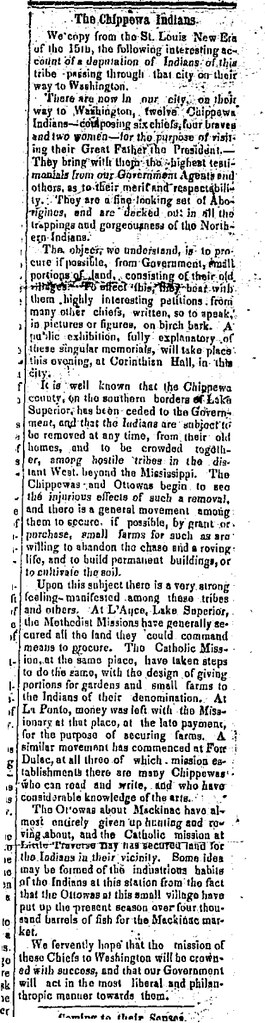
This point was made clear to me once again as I tried to sort out my lingering questions about the 1848-49 “Martell” Delegation to Washington. If you are a regular reader, you may remember that this delegation was the subject of the first post on this website. You may also remember from this post, that the group did not have money to get to Washington and had to reach out to the people they encountered along the way.
The goal of the Martell Delegation was to get the United States to cede back title to the lands surrounding the major Lake Superior Ojibwe villages. The Ojibwe had given this land up in the Treaty of 1842 with the guarantee that they could remain on it. However, by 1848 there were rumors of removal of all the bands east of the Mississippi to unceded land in Minnesota. That removal was eventually attempted, in 1850-51, in what is now called the Sandy Lake Tragedy.
The Martell Delegation remains a little-known part of the removal story, although the pictographs remain popular. Those petitions are remembered because they were published in Henry Schoolcrafts’ Historical and statistical information respecting the history, condition, and prospects of the Indian tribes of the United States (1851) along with the most accessible primary account of the delegation:
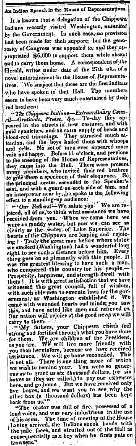
In the month of January, 1849, a delegation of eleven Chippewas, from Lake Superior, presented themselves at Washington, who, amid other matters not well digested in their minds, asked the government for a retrocession of some portion of the lands which the nation had formerly ceded to the United States, at a treaty concluded at Lapointe, in Lake Superior, in 1842. They were headed by Oshcabawiss, a chief from a part of the forest-country, called by them Monomonecau, on the head-waters of the River Wisconsin. Some minor chiefs accompanied them, together with a Sioux and two boisbrules, or half-breeds, from the Sault Ste. Marie, Michigan. The principal of the latter was a person called Martell, who appeared to be the master-spirit and prime mover of the visit, and of the motions of the entire party. His motives in originating and conducting the party, were questioned in letters and verbal representations from persons on the frontiers. He was freely pronounced an adventurer, and a person who had other objects to fulfil, of higher interest to himself than the advancement of the civilization and industry of the Indians. Yet these were the ostensible objects put forward, though it was known that he had exhibited the Indians in various parts of the Union for gain, and had set out with the purpose of carrying them, for the same object, to England. However this may be, much interest in, and sympathy for them, was excited. Officially, indeed, their object was blocked up. The party were not accredited by their local agent. They brought no letter from the acting Superintendent of Indian Affairs on that frontier. The journey had not been authorized in any manner by the department. It was, in fine, wholly voluntary, and the expenses of it had been defrayed, as already indicated, chiefly from contributions made by citizens on the way, and from the avails of their exhibitions in the towns through which they passed; in which, arrayed in their national costume, they exhibited their peculiar dances, and native implements of war and music. What was wanting, in addition to these sources, had been supplied by borrowing from individuals.
Engraving of Henry Schoolcraft by Wellstood and Peters (Photo credit: Wikipedia)
Martell, who acted as their conductor and interpreter, brought private letters from several persons to members of Congress and others, which procured respect. After a visit, protracted through seven or eight weeks, an act was passed by Congress to defray the expenses of the party, including the repayment of the sums borrowed of citizens, and sufficient to carry them back, with every requisite comfort, to their homes in the north-west. While in Washington, the presence of the party at private houses, at levees, and places of public resort, and at the halls of Congress, attracted much interest; and this was not a little heightened by their aptness in the native ceremonies, dancing, and their orderly conduct and easy manners, united to the attraction of their neat and well-preserved costume, which helped forward the object of their mission.
The visit, although it has been stated, from respectable sources, to have had its origin wholly in private motives, in the carrying out of which the natives were made to play the part of mere subordinates, was concluded in a manner which reflects the highest credit on the liberal feelings and sentiments of Congress. The plan of retrocession of territory, on which some of the natives expressed a wish to settle and adopt the modes of civilized life, appeared to want the sanction of the several states in which the lands asked for lie. No action upon it could therefore be well had, until the legislatures of these states could be consulted (pg. 414-416, pictographic plates follow).

I have always had trouble with Schoolcraft’s interpretation of these events. It wasn’t that I had evidence to contradict his argument, but rather that I had a hard time believing that all these chiefs would make so weighty a decision as to go to Washington simply because their interpreter was trying to get rich. The petitions asked for a permanent homeland in the traditional villages east of the Mississippi. This was the major political goal of the Lake Superior Ojibwe leadership at that time and would remain so in all the years leading up to 1854. Furthermore, chiefs continued to ask for, or go “uninvited” on, diplomatic missions to the president in the years that followed.
I explored some of this in the post about the pictograph, but a number of lingering questions remained:
What route did this group take to Washington?
Who was Major John Baptiste Martell?
Did he manipulate the chiefs into working for him, or was he working for them?
Was the Naaganab who went with this group the well-known Fond du Lac chief or the warrior from Lake Chetek with the same name?
Did any chiefs from the La Pointe band go?
Why was Martell criticized so much? Did he steal the money?
What became of Martell after the expedition?
How did the “Martell Expedition” of 1848-49 impact the Ojibwe removal of 1850-51?
Lacking access to the really good archives on this subject, I decided to focus on newspapers, and since this expedition received so much attention and publicity, this was a good choice. Enjoy:
Indiana Palladium. Vevay, IN. Dec. 2, 1848
Capt. Seth Eastman of the U.S. Army took note of the delegation as it traveled down the Mississippi from Fort Snelling to St. Louis. Eastman, a famous painter of American Indians, copied the birch bark petitions for publication in the works of his collaborator Henry Schoolcraft. At least one St. Louis paper also noticed these unique pictographic documents.
 Lafayette Courier. Lafayette, IN. Dec. 8, 1848.
The delegation made its way up the Ohio River to Cincinnati, where Gezhiiyaash’s illness led to a chance encounter with some Ohio Freemasons. I won’t repeat it here, but I covered this unusual story in this post from August.
At Cincinnati, they left the river and headed toward Columbus. Just east of that city, on the way to Pittsburgh, one of the Ojibwe men offered some sound advice to the women of Hartford, Ohio, but he received only ridicule in return.
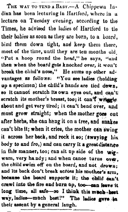
Madison Weekly Courier. Madison, IN. Jan. 24, 1849

It’s unclear how quickly reports of the delegation came back to the Lake Superior country. William Warren’s letter to his cousin George, written in March after the delegation had already left Washington, still spoke of St. Louis:
William W. Warren (Wikimedia Images)
“…About Martells Chiefs. They were according to last accounts dancing the pipe dance at St. Louis. They have been making monkeys of themselves to fill the pockets of some cute Yankee who has got hold of them. Black bird returned from Cleveland where he caught scarlet fever and clap. He has behaved uncommon well since his return…” (Schenck, pg. 49)

From this letter, we learn that Blackbird, the La Pointe chief, was originally part of the group. In evaluating Warren’s critical tone, we must remember that he was working closely with the very government officials who withheld their permission. Of the La Pointe chiefs, Blackbird was probably the least accepting of American colonial power. However, we see in the obituary of Naaganab, Blackbird’s rival at the 1855 annuity payment, that the Fond du Lac chief was also there.
New York World. New York. July 22, 1894
Before finding this obituary, I had thought that the Naaganab who signed the petition was more likely the headman from Lake Chetek. Instead, this information suggests it was the more famous Fond du Lac chief. This matters because in 1848, Naaganab was considered the speaker for his cousin Zhingob, the leading chief at Fond du Lac. Blackbird, according to his son James, was the pipe carrier for Buffalo. While these chiefs had their differences with each other, it seems likely that they were representing their bands in an official capacity. This means that the support for this delegation was not only from “minor chiefs” as Schoolcraft described them, or “Martells Chiefs” as Warren did, from Lac du Flambeau and Michigan. I would argue that the presence of Blackbird and Naaganab suggests widespread support from the Lake Superior bands. I would guess that there was much discussion of the merits of a Washington delegation by Buffalo and others during the summer of 1848, and that the trip being a hasty money-making scheme by Martell seems much less likely.
Madison Daily Banner. Madison, IN. Jan. 3, 1849.
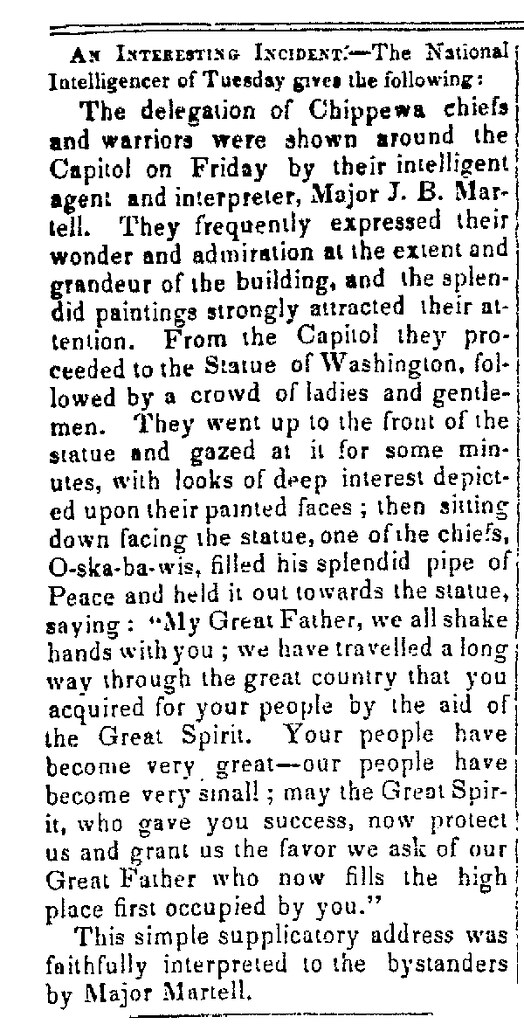
From Pittsburgh, the delegation made it to Philadelphia, and finally Washington. They attracted a lot of attention in the nation’s capital. Some of their adventures and trials: Oshkaabewis and his wife Pammawaygeonenoqua losing an infant child, the group hunting rabbits along the Potomac, and the chiefs taking over Congress, are included this post from March, so they aren’t repeated here.
Adams Sentinel. Gettysburg, PA. Feb. 5, 1849.
According to Ronald Satz, the delegation was received by both Congress and President Polk with “kindly feelings” and the expectation of “good treatment in the future” if they “behaved themselves (Satz 51).” Their petition was added to the Congressional Record, but the reservations were not granted at the time. However, Congress did take up the issue of paying for the debts accrued by the Ojibwe along the way.


George Copway (Wikimedia Commons)
Kah-Ge-Ga-Gah-Bowh (George Copway), a Mississauga Ojibwe and Methodist missionary, was the person “belonging to one of the Canada Bands of Chippewas,” who wrote the anti-Martell letter to Indian Commissioner William Medill. This is most likely the letter Schoolcraft referred to in 1851. In addition to being upset about the drinking, Copway was against reservations in Wisconsin. He wanted the government to create a huge pan-Indian colony at the headwaters of the Missouri River.

William Medill (Wikimedia Commons)
Iowa State Gazette. Burlington, IA. April 4, 1849
~~~~~~~~~~~~~~~~~~
~~~~~~~~~~~~~~~~~~~~~~~~~~~~~~~~~~~~~~~~~~~~~~~~~~~~~~~~~
 Weekly Wisconsin. Milwaukee. Feb. 28, 1849.
With $6000 (or did they only get $5000?), a substantial sum for the antebellum Federal Government, the group prepared to head back west with the ability to pay back their creditors.
It appears the chiefs returned to their villages by going back though the Great Lakes to Green Bay and then overland.
The Chippewa Delegation, who have been on a visit to see their “great fathers” in Washington, passed through this place on Saturday last, on their way to their homes near Lake Superior. From the accounts of the newspapers, they have been lionized during their whole journey, and particularly in Washington, where many presents were made them, among the most substantial of which was six boxed of silver ($6,000) to pay their expenses. They were loaded with presents, and we noticed one with a modern style trunk strapped to his back. They all looked well and in good spirits (qtd. in Paap, pg. 205).
Green Bay Gazette. April 4, 1849
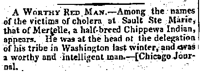
So, it hardly seems that the Ojibwe chiefs returned to their villages feeling ripped off by their interpreter. Martell himself returned to the Soo, and found a community about to be ravaged by a epidemic of cholera.
Weekly Wisconsin. Milwaukee. Sep. 5, 1849.
Martell appears in the 1850 census on the record of those deceased in the past year. Whether he was a major in the Mexican War, whether he was in the United States or Canadian military, or whether it was even a real title, remains a mystery. His death record lists his birthplace as Minnesota, which probably connects him to the Martells of Red Lake and Red River, but little else is known about his early years. And while we can’t say for certain whether he led the group purely out of self-interest, or whether he genuinely supported the cause, John Baptiste Martell must be remembered as a key figure in the struggle for a permanent Ojibwe homeland in Wisconsin and Michigan. He didn’t live to see his fortieth birthday, but he made the 1848-49 Washington delegation possible.
So how do we sort all this out?
To refresh, my unanswered questions from the other posts about this delegation were:
1) What route did this group take to Washington?
2) Who was Major John Baptiste Martell?
3) Did he manipulate the chiefs into working for him, or was he working for them?
4) Was the Naaganab who went with this group the well-known Fond du Lac chief or the warrior from Lake Chetek with the same name?
5) Did any chiefs from the La Pointe band go?
6) Why was Martell criticized so much? Did he steal the money?
7) What became of Martell after the expedition?
8) How did the “Martell Expedition” of 1848-49 impact the Ojibwe removal of 1850-51?
We’ll start with the easiest and work our way to the hardest. We know that the primary route to Washington was down the Brule, St. Croix, and Mississippi to St. Louis, and from there up the Ohio. The return trip appears to have been via the Great Lakes.
We still don’t know how Martell became a major, but we do know what became of him after the diplomatic mission. He didn’t survive to see the end of 1849.
The Fond du Lac chief Naaganab, and the La Pointe chief Blackbird, were part of the group. This indicates that a wide swath of the Lake Superior Ojibwe leadership supported the delegation, and casts serious doubt on the notion that it was a few minor chiefs in Michigan manipulated by Martell.
Until further evidence surfaces, there is no reason to support Schoolcraft’s accusations toward Martell. Even though these allegations are seemingly validated by Warren and Copway, we need to remember how these three men fit into the story. Schoolcraft had moved to Washington D.C. by this point and was no longer Ojibwe agent, but he obviously supported the power of the Indian agents and favored the assimilation of his mother-in-law’s people. Copway and Warren also worked closely with the Government, and both supported removal as a way to separate the Ojibwe from the destructive influences of the encroaching white population. These views were completely opposed to what the chiefs were asking for: permanent reservations at the traditional villages. Because of this, we need to consider that Schoolcraft, Warren, and Copway would be negatively biased toward this group and its interpreter.
Finally there’s the question Howard Paap raises in Red Cliff, Wisconsin. How did this delegation impact the political developments of the early 1850s? In one sense the chiefs were clearly pleased with the results of the trip. They made many friends in Congress, in the media, and in several American cities. They came home smiling with gifts and money to spread to their people. However, they didn’t obtain their primary goal: reservations east of the Mississippi, and for this reason, the following statement in Schoolcraft’s account stands out:
The plan of retrocession of territory, on which some of the natives expressed a wish to settle and adopt the modes of civilized life, appeared to want the sanction of the several states in which the lands asked for lie. No action upon it could therefore be well had, until the legislatures of these states could be consulted.
“Kindly feelings” from President Polk didn’t mean much when Zachary Taylor and a new Whig administration were on the way in. Meanwhile, Congress and the media were so wrapped up in the national debate over slavery that they forgot all about the concerns of the Ojibwes of Lake Superior. This allowed a handful of Indian Department officials, corrupt traders, and a crooked, incompetent Minnesota Territorial governor named Alexander Ramsey to force a removal in 1850 that resulted in the deaths of 400 Ojibwe people in the Sandy Lake Tragedy.
It is hard to know how the chiefs felt about their 1848-49 diplomatic mission after Sandy Lake. Certainly their must have been a strong sense that they were betrayed and abandoned by a Government that had indicated it would support them, but the idea of bypassing the agents and territorial officials and going directly to the seat of government remained strong. Another, much more famous, “uninvited” delegation brought Buffalo and Oshogay to Washington in 1852, and ultimately the Federal Government did step in to grant the Ojibwe the reservations. Almost all of the chiefs who made the journey, or were shown in the pictographs, signed the Treaty of 1854 that made them.
Sources:
McClurken, James M., and Charles E. Cleland. Fish in the Lakes, Wild Rice, and Game in Abundance: Testimony on Behalf of Mille Lacs Ojibwe Hunting and Fishing Rights / James M. McClurken, Compiler ; with Charles E. Cleland … [et Al.]. East Lansing, MI: Michigan State UP, 2000. Print.
Paap, Howard D. Red Cliff, Wisconsin: A History of an Ojibwe Community. St. Cloud, MN: North Star, 2013. Print.
Satz, Ronald N. Chippewa Treaty Rights: The Reserved Rights of Wisconsin’s Chippewa Indians in Historical Perspective. Madison, WI: Wisconsin Academy of Sciences, Arts and Letters, 1991. Print.
Schenck, Theresa M. William W. Warren: The Life, Letters, and times of an Ojibwe Leader. Lincoln: University of Nebraska, 2007. Print.
Schoolcraft, Henry Rowe, and Seth Eastman. Historical and Statistical Information Respecting the History, Condition, and Prospects of the Indian Tribes of the United States: Collected and Prepared under the Direction of the Bureau of Indian Affairs per Act of Congress of March 3rd, 1847. Philadelphia: Lippincott, Grambo, 1851. Print.
CAUTION: This translation was made using Google Translate by someone who neither speaks nor reads German. It should not be considered accurate by scholarly standards.

Moritz Wagner (1813-1887) (Wikimedia Images)
Americans love travelogues. From de Tocqueville’s Democracy in America, to Twain’s Roughing It, to Steinbeck’s Travels with Charley, a few pages of a well-written travelogue by a random interloper can often help a reader picture a distant society more clearly than volumes of documents produced by actual members of the community. And while travel writers often misinterpret what they see, their works remain popular long into the future. When you think about it, this isn’t surprising. The genre is built on helping unfamiliar readers interpret a place that is different, whether by space or time, from the one they inhabit. The travel writer explains everything in a nice summary and doesn’t assume the reader knows the subject.
You can imagine, then, my excitement when I accidentally stumbled upon a largely-unknown and untranslated travelogue from 1852 that devotes several pages to to the greater Chequamegon region.
I was playing around on Google Books looking for variants of Chief Buffalo’s name from sources in the 1850s. Those of you who read regularly know that the 1850s were a decade of massive change in this area, and the subject of many of my posts. I was surprised to see one of the results come back in German. The passage clearly included the words Old Buffalo, Pezhickee, La Pointe, and Chippewa, but otherwise, nothing. I don’t speak any German, and I couldn’t decipher all the letters of the old German font.

Karl (Carl) Ritter von Scherzer (1821-1903) (Wikimedia Images)
The book was Reisen in Nordamerika in den Jahren 1852 und 1853 (Travels in North America in the years 1852 and 1853) by the Austrian travel writers Dr. Moritz Wagner and Dr. Carl Scherzer. These two men traveled throughout the world in the mid 19th-century and became well-known figures in Europe as writers, government officials, and scientists. In America, however, Reisen in Nordamerika never caught on. It rests in a handful of libraries, but as far as I can find, it has never been translated into English.
Chapter 21, From Ontonagon to the Mouth of the Bois-brule River, was the chapter I was most interested in. Over the course of a couple of weeks, I plugged paragraphs into Google Translate, about 50 pages worth.
Here is the result (with the caveat that it was e-translated, and I don’t actually know German). Normally I clog up my posts with analysis, but I prefer to let this one stand on its own. Enjoy:
XXI
From Ontonagon to the mouth of the Bois-brule River–Canoe ride to Magdalen Island–Porcupine Mountains–Camping in the open air–A dangerous canoe landing at night–A hospitable Jewish family–The island of La Pointe–The American Fur Company–The voyageurs or courriers de bois–Old Buffalo, the 90 year-old Chippewa chief–A schoolhouse and an examination–The Austrian Franciscan monk–Sunday mass and reflections on the Catholic missions–Continuing the journey by sail–Nous sommes degrades–A canoeman and apostle of temperance–Fond du lac–Sauvons-nous!
On September 15th, we were under a cloudless sky with the thermometer showing 37°F. In a birch canoe, we set out for Magdalene Island (La Pointe). Our intention was to drive up the great Lake Superior to its western end, then up the St. Louis and Savannah Rivers, to Sandy Lake on the eastern bank of the Mississippi River. Our crew consisted of a young Frenchman of noble birth and education and a captain of the U.S. Navy. Four French Canadians were the leaders of the canoes. Their trustworthy, cheerful, sprightly, and fearless natures carried us so bravely against the thundering waves, that they probably could have even rowed us across the river Styx.
Upon embarkation, an argument broke out between passengers and crew over the issue of overloading the boat. It was only conditioned to hold our many pieces of baggage and the provisions to be acquired along the way. However, our mercenary pilot produced several bags and packages, for which he could be well paid, by carrying them Madeline Island as freight.
Shortly after our exit, the weather hit us and a strong north wind obliged us to pull to shore and make Irish camp, after we had only covered four English miles to the Attacas (Cranberry) Rive,r one of the numerous mountain streams that pour into Lake Superior. We brought enough food from Ontonagon to provide for us for approximately 14 days of travel. The settlers of La Pointe, which is the last point on the lake where whites live, provided for themselves only scanty provisions. A heavy bag of ship’s biscuit was at the end of one canoe, and a second sack contained tea, sugar, flour, and some rice. A small basket contained our cooking and dining utensils.
The captain believed that all these supplies would be unecessary because the bush and fishing would provide us with the richest delicacies. But already in the next lunch hour, when we caught sight of no wild fowl, he said that we must prepare the rice. It was delicious with sugar. Dry wood was collected and a merry flickering fire prepared. An iron kettle hung from birch branches crossed akimbo, and the water soon boiled and evaporated. The sea air was fresh, and the sun shone brightly. The noise of the oncoming waves sounded like martial music to the unfinished ear, so we longed for the peaceful quiet lake. The shore was flat and sandy, but the main attraction of the scenery was in the gigantic forest trees and the richness of their leafy ornaments.
At a quarter to 3 o’clock, we left the bivouac as there was no more wind, and by 3 o’clock, with our camp still visible, the water became weaker and weaker and soon showed tree and cloud upon its smooth surface. We passed the Porcupine Mountains, a mountain range made of trapp geological formation. We observed that some years ago, a large number of inexperienced speculators sunk shafts and made a great number of investments in anticipation of a rich copper discovery. Now everything is destroyed and deserted and only the green arbor vitae remain on the steep trap rocks.
Our night was pretty and serene, so we went uninterrupted until 1 o’clock in the morning. Our experienced boatmen did not trust the deceptive smoothness of the lake, however, and they uttered repeated fears that storms would interrupt our trip. It happens quite often that people who travel in late autumn for pleasure or necessity from Ontonagon to Magdalene Island, 70 miles away, are by sea storms prevented from travelling that geographically-small route for as many as 6 or 8 days.
Used to the life of the Indians in the primeval forests, for whom even in places of civilization prefer the green carpet under the open sky to the soft rug and closed room, the elements could not dampen the emotion of the paddlers of the canoe or force out the pleasure of the chase.* But for Europeans, all sense of romantic adventure is gone when in such a forest for days without protection from the heavy rain and without shelter from the cold eeriness for his shivering limbs.
(*We were accompanied on our trip throughout the lakes of western Canada by half-Indians who had paternal European blood in their veins. Yet so often, a situation would allow us to spend a night inside rather than outdoors, but they always asked us to choose to Irish camp outside with the Indians, who lived at the various places. Although one spoke excellent English, and they were both drawn more to the great American race, they thought, felt, and spoke—Indian!)
It is amazing the carelessness with which the camp is set near the sparks of the crackling fire. An overwhelming calm is needed to prevent frequent accidents, or even loss of human life, from falling on the brands. As we were getting ready to continue our journey early in the morning, we found the front part of our tent riddled with a myriad of flickering sparks.
16 September (50° Fahrenheit)*) Black River, seven miles past Presque Isle. Gradually the shore area becomes rolling hills around Black River Mountain, which is about 100 feet in height. Frequently, immense masses of rock protrude along the banks and make a sudden landing impossible. This difficulty to reach shore, which can stretch for several miles long, is why a competent captain will only risk a daring canoe crossing on a fairly calm lake.
(*We checked the thermometer regularly every morning at 7 o’clock, and when travel conditions allowed it, at noon and evening.)
At Little Girl’s Point, a name linked to a romantic legend, we prepared lunch from the unfinished bread from the day before. We had rice, tea, and the remains of the bread we brought from a bakery in Ontonagon from our first days.
In the afternoon, we met at a distance a canoe with two Indians and a traveler going in an easterly direction. We got close enough to ask some short questions in telegraph style. We asked, “Where do you go? How is the water in the St. Louis and Savannah River?”
We were answered in the same brevity that they were from Crow Wing going to Ontonagon, and that the rivers were almost dried from a month-long lack of rain.
The last information was of utmost importance to us for it changed, all of a sudden, the fibers of our entire itinerary. With the state of the rivers, we would have to do most of the 300-mile long route on foot which neither the advanced season of the year, nor the sandy steppes invited. If we had been able to extend our trip, we could have visited Itasca Lake, the cradle of the Mississippi, where only a few historically-impressive researchers and travelers have passed near: Pike, Cass, Schoolcraft, Nicollet, and to our knowledge, no Austrian.
However, this was impossible considering our lack of necessary academic preparation and in consideration of the economy of our travel plan. We do not like the error, we would almost say vice, of so many travelers who rush in hasty discontent, supported by modern transport, through wonderful parts of creation without gaining any knowledge of the land’s physical history and the fate of its inhabitants.*
(*We were told here recently of such a German tourist who traveled through Mexico in only a fortnight– i.e. 6 days from Veracruz to the capital and 6 days back with only two days in the capital!)
While driving, the boatmen sang alternately. They were, for the most part, frivolous love songs and not of the least philological or ethnographic interest.
After 2 o’clock, we passed the rocks of the Montreal River. They run for about six miles with a long drag reaching up to an altitude of 100 feet. There are layers of shale and red sandstone, all of which run east to west. By weathering, they have obtained such a dyed-painting appearance, that you can see in their marbled colors something resembling a washed-out image.
The Montreal* is a major tributary of Lake Superior. About 300 steps up from where it empties into the lake, it forms a very pretty waterfall surrounded by an impressive pool. Rugged cliffs form the 80’ falls over a vertical sandstone layer and form a lovely valley. The width of the Montreal is 10’, and it also forms the border between the states of Michigan and Wisconsin.
(*Indian: Ka-wa’-si-gi-nong sepi, the white flowing falls.)
We stayed in this cute little bay for over an hour as our frail canoes had begun to take on a questionable amount of water as the result of some wicked stone wounds.
Up from Montreal River heading towards La Pointe, the earlier red sandstone formation starts again, and the rich shaded hills and rugged cliffs disappear suddenly. Around 6 o’clock, we rested for half an hour at the mouth of the Bad River of Lake Superior. We quickly prepared our evening snack as the possibility of reaching Magdalene Island that same night was still in contention.
Across from us, on the western shore of Bad River*, we saw Indians by a warm fire. One of the boatmen suspected they’d come back from catching fish, and he called in a loud voice across the river asking if they wanted to come over and sell us some. We took their response, and soon shy Indian women (squaws) appeared. Lacking a male, they dreaded to get involved in trading with Whites, and did not like the return we offered.
(*On Bad River, a Methodist Mission was founded in 1841. It consists of the missionary, his wife, and a female teacher. Their sphere of influence is limited to dispensing divine teaching only to those wandering tribes of Chippewa Indians that come here every year during the season of fishing, to divest the birch tree of its bark, and to build it into a shelter).
A part of our nightly trip was spent fantastically in blissful contemplation of the wonders above us and next to us. Night sent the cool fragrance of the forest to our lonely rocking boat, and the sky was studded with stars that sparkled through the green branches of the woods. Soon, luminous insects appeared on the tops of the trees in equally brilliant bouquets.
At 11 o’clock at night, we saw a magnificent aurora borealis, which left such a bright scent upon the dark blue sky. However, the theater soon changed scene, and a fierce south wind moved in incredibly fast. What had just been a quietly slumbering lake, as if inhabited by underwater ghosts, struck the alarm and suddenly tumultuous waves approached the boat. With the faster waves wanting to forestall the slower, a raging tumult arose resembling the dirt thrown up by great wagon wheels.
We were directly in the middle of that powerful watery surface, about one and one half miles from the mainland and from the nearest south bank of the island. It would have been of no advantage to reverse course as it required no more time to reach the island as to go back. At the outbreak of this dangerous storm, our boatmen were still determined to reach La Pointe.
But when several times the beating waves began to fill our boat from all sides with water, the situation became much more serious. As if to increase our misery, at almost the same moment a darkness concealed the sky and gloomy clouds veiled the stars and northern lights, and with them went our cheerful countenance.
Now singing, our boatmen spoke with anxious gestures and an unintelligible patois to our fellow traveler. The captain said jokingly, that they took counsel to see who should be thrown in the water first should the danger increase. We replied in a like manner that it was never our desire to be first and that we felt the captain should keep that honor. Fortunately, all our concern soon ended as we landed at La Pointe (Chegoimegon).
To be continued…
CAUTION: This translation was made using Google Translate by someone who neither speaks nor reads German. It should not be considered accurate by scholarly standards.
Oshogay
August 12, 2013
At the most recent count, Chief Buffalo is mentioned in over two-thirds of the posts here on Chequamegon History. That’s the most of anyone listed so far in the People Index. While there are more Buffalo posts on the way, I also want to draw attention to some of the lesser known leaders of the La Pointe Band. So, look for upcoming posts about Dagwagaane (Tagwagane), Mizay, Blackbird, Waabojiig, Andeg-wiiyas, and others. I want to start, however, with Oshogay, the young speaker who traveled to Washington with Buffalo in 1852 only to die the next year before the treaty he was seeking could be negotiated.
I debated whether to do this post, since I don’t know a lot about Oshogay. I don’t know for sure what his name means, so I don’t know how to spell or pronounce it correctly (in the sources you see Oshogay, O-sho-ga, Osh-a-ga, Oshaga, Ozhoge, etc.). In fact, I don’t even know how many people he is. There were at least four men with that name among the Lake Superior Ojibwe between 1800 and 1860, so much like with the Great Chief Buffalo Picture Search, the key to getting Oshogay’s history right is dependent on separating his story from those who share his name.
In the end, I felt that challenge was worth a post in its own right, so here it is.
Getting Started
According to his gravestone, Oshogay was 51 when he died at La Pointe in 1853. That would put his birth around 1802. However, the Ojibwe did not track their birthdays in those days, so that should not be considered absolutely precise. He was considered a young man of the La Pointe Band at the time of his death. In my mind, the easiest way to sort out the information is going to be to lay it out chronologically. Here it goes:
1) Henry Schoolcraft, United States Indian Agent at Sault Ste. Marie, recorded the following on July 19, 1828:
Oshogay (the Osprey), solicited provisions to return home. This young man had been sent down to deliver a speech from his father, Kabamappa, of the river St. Croix, in which he regretted his inability to come in person. The father had first attracted my notice at the treaty of Prairie du Chien, and afterwards received a small medal, by my recommendation, from the Commissioners at Fond du Lac. He appeared to consider himself under obligations to renew the assurance of his friendship, and this, with the hope of receiving some presents, appeared to constitute the object of his son’s mission, who conducted himself with more modesty and timidity before me than prudence afterwards; for, by extending his visit to Drummond Island, where both he and his father were unknown, he got nothing, and forfeited the right to claim anything for himself on his return here.
I sent, however, in his charge, a present of goods of small amount, to be delivered to his father, who has not countenanced his foreign visit.
Oshogay is a “young man.” A birth year of 1802 would make him 26. He is part of Gaa-bimabi’s (Kabamappa’s) village in the upper St. Croix country.
2) In June of 1834, Edmund Ely and W. T. Boutwell, two missionaries, traveled from Fond du Lac (today’s Fond du Lac Reservation near Cloquet) down the St. Croix to Yellow Lake (near today’s Webster, WI) to meet with other missionaries. As they left Gaa-bimabi’s (Kabamappa’s) village near the head of the St. Croix and reached the Namekagon River on June 28th, they were looking for someone to guide them the rest of the way. An old Ojibwe man, who Boutwell had met before at La Pointe, and his son offered to help. The man fed the missionaries fish and hunted for them while they camped a full day at the mouth of the Namekagon since the 29th was a Sunday and they refused to travel on the Sabbath. On Monday the 30th, the reembarked, and Ely recorded in his journal:
The man, whose name is “Ozhoge,” and his son embarked with us about 1/2 past 9 °clk a.m. The old man in the bow and myself steering. We run the rapids safely. At half past one P. M. arrived at the mouth of Yellow River…
Ozhoge is an “old man” in 1834, so he couldn’t have been born in 1802. He is staying on the Namekagon River in the upper St. Croix country between Gaa-bimabi and the Yellow Lake Band. He had recently spent time at La Pointe.
3) Ely’s stay on the St. Croix that summer was brief. He was stationed at Fond du Lac until he eventually wore out his welcome there. In the 1840s, he would be stationed at Pokegama, lower on the St. Croix. During these years, he makes multiple references to a man named Ozhogens (a diminutive of Ozhoge). Ozhogens is always found above Yellow River on the upper St. Croix.
Ozhogens has a name that may imply someone older (possibly a father or other relative) lives nearby with the name Ozhoge. He seems to live in the upper St. Croix country. A birth year of 1802 would put him in his forties, which is plausible.

Ke-che-wask keenk (Gichi-weshki) is Chief Buffalo. Gab-im-ub-be (Gaa-bimabi) was the chief Schoolcraft identified as the father of Oshogay. Ja-che-go-onk was a son of Chief Buffalo.
4) On August 2, 1847, the United States and the Mississippi and Lake Superior Ojibwe concluded a treaty at Fond du Lac. The US Government wanted Ojibwe land along the nation’s border with the Dakota Sioux, so it could remove the Ho-Chunk people from Wisconsin to Minnesota.
Among the signatures, we find O-sho-gaz, a warrior from St. Croix. This would seem to be the Ozhogens we meet in Ely.
Here O-sho-gaz is clearly identified as being from St. Croix. His identification as a warrior would probably indicate that he is a relatively young man. The fact that his signature is squeezed in the middle of the names of members of the La Pointe Band may or may not be significant. The signatures on the 1847 Treaty are not officially grouped by band, but they tend to cluster as such.
5) In 1848 and 1849 George P. Warren operated the fur post at Chippewa Falls and kept a log that has been transcribed and digitized by the University of Wisconsin Eau Claire. He makes several transactions with a man named Oshogay, and at one point seems to have him employed in his business. His age isn’t indicated, but the amount of furs he brings in suggests that he is the head of a small band or large family. There were multiple Ojibwe villages on the Chippewa River at that time, including at Rice Lake and Lake Shatac (Chetek). The United States Government treated with them as satellite villages of the Lac Courte Oreilles Band.
Based on where he lives, this Oshogay might not be the same person as the one described above.
6) In December 1850, the Wisconsin Supreme Court ruled in the case Oshoga vs. The State of Wisconsin, that there were a number of irregularities in the trial that convicted “Oshoga, an Indian of the Chippewa Nation” of murder. The court reversed the decision of the St. Croix County circuit court. I’ve found surprisingly little about this case, though that part of Wisconsin was growing very violent in the 1840s as white lumbermen and liquor salesmen were flooding the country.

Pg 56 of Containing cases decided from the December term, 1850, until the organization of the separate Supreme Court in 1853: Volume 3 of Reports of Cases Argued and Determined in the Supreme Court of the State of Wisconsin: With Tables of the Cases and Principal Matters, and the Rules of the Several Courts in Force Since 1838, Wisconsin. Supreme Court Authors: Wisconsin. Supreme Court, Silas Uriah Pinney (Google Books).
The man killed, Alexander Livingston, was a liquor dealer himself.
Alexander Livingston, a man who in youth had had excellent advantages, became himself a dealer in whisky, at the mouth of Wolf creek, in a drunken melee in his own store was shot and killed by Robido, a half-breed. Robido was arrested but managed to escape justice.
~From Fifty Years in the Northwest by W.H.C Folsom
Several pages later, Folsom writes:
At the mouth of Wolf creek, in the extreme northwestern section of this town, J. R. Brown had a trading house in the ’30s, and Louis Roberts in the ’40s. At this place Alex. Livingston, another trader, was killed by Indians in 1849. Livingston had built him a comfortable home, which he made a stopping place for the weary traveler, whom he fed on wild rice, maple sugar, venison, bear meat, muskrats, wild fowl and flour bread, all decently prepared by his Indian wife. Mr. Livingston was killed by an Indian in 1849.
Folsom makes no mention of Oshoga, and I haven’t found anything else on what happened to him or Robido (Robideaux?).
It’s hard to say if this Oshoga is the Ozhogen’s of Ely’s journals or the Oshogay of Warren’s. Wolf Creek is on the St. Croix, but it’s not far from the Chippewa River country either, and the Oshogay of Warren seems to have covered a lot of ground in the fur trade. Warren’s journal, linked in #4, contains a similar story of a killing and “frontier justice” leading to lynch mobs against the Ojibwe. To escape the violence and overcrowding, many Ojibwe from that part of the country started to relocate to Fond du Lac, Lac Courte Oreilles, or La Pointe/Bad River. La Pointe is also where we find the next mention of Oshogay.
7) From 1851 to 1853, a new voice emerged loudly from the La Pointe Band in the aftermath of the Sandy Lake Tragedy. It was that of Buffalo’s speaker Oshogay (or O-sho-ga), and he spoke out strongly against Indian Agent John Watrous’ handling of the Sandy Lake payments (see this post) and against Watrous’ continued demands for removal of the Lake Superior Ojibwe. There are a number of documents with Oshogay’s name on them, and I won’t mention all of them, but I recommend Theresa Schenck’s William W. Warren and Howard Paap’s Red Cliff, Wisconsin as two places to get started.
Chief Buffalo was known as a great speaker, but he was nearing the end of his life, and it was the younger chief who was speaking on behalf of the band more and more. Oshogay represented Buffalo in St. Paul, co-wrote a number of letters with him, and most famously, did most of the talking when the two chiefs went to Washington D.C. in the spring of 1852 (at least according to Benjamin Armstrong’s memoir). A number of secondary sources suggest that Oshogay was Buffalo’s son or son-in-law, but I’ve yet to see these claims backed up with an original document. However, all the documents that identify by band, say this Oshogay was from La Pointe.
The Wisconsin Historical Society has digitized four petitions drafted in the fall of 1851 and winter of 1852. The petitions are from several chiefs, mostly of the La Pointe and Lac Courte Oreilles/Chippewa River bands, calling for the removal of John Watrous as Indian Agent. The content of the petitions deserves its own post, so for now we’ll only look at the signatures.

November 6, 1851 Letter from 30 chiefs and headmen to Luke Lea, Commissioner of Indian Affairs: Multiple villages are represented here, roughly grouped by band. Kijiueshki (Buffalo), Jejigwaig (Buffalo’s son), Kishhitauag (“Cut Ear” also associated with the Ontonagon Band), Misai (“Lawyerfish”), Oshkinaue (“Youth”), Aitauigizhik (“Each Side of the Sky”), Medueguon, and Makudeuakuat (“Black Cloud”) are all known members of the La Pointe Band. Before the 1850s, Kabemabe (Gaa-bimabi) and Ozhoge were associated with the villages of the Upper St. Croix.

November 8, 1851, Letter from the Chiefs and Headmen of Chippeway River, Lac Coutereille, Puk-wa-none, Long Lake, and Lac Shatac to Alexander Ramsey, Superintendent of Indian Affairs: This letter was written from Sandy Lake two days after the one above it was written from La Pointe. O-sho-gay the warrior from Lac Shatac (Lake Chetek) can’t be the same person as Ozhoge the chief unless he had some kind of airplane or helicopter back in 1851.

Undated (Jan. 1852?) petition to “Our Great Father”: This Oshoga is clearly the one from Lake Chetek (Chippewa River).

Undated (Jan. 1852?) petition: These men are all associated with the La Pointe Band. Osho-gay is their Speaker.
In the early 1850s, we clearly have two different men named Oshogay involved in the politics of the Lake Superior Ojibwe. One is a young warrior from the Chippewa River country, and the other is a rising leader among the La Pointe Band.

Washington Delegation July 22, 1852 This engraving of the 1852 delegation led by Buffalo and Oshogay appeared in Benjamin Armstrong’s Early Life Among the Indians. Look for an upcoming post dedicated to this image.
8) In the winter of 1853-1854, a smallpox epidemic ripped through La Pointe and claimed the lives of a number of its residents including that of Oshogay. It had appeared that Buffalo was grooming him to take over leadership of the La Pointe Band, but his tragic death left a leadership vacuum after the establishment of reservations and the death of Buffalo in 1855.
Oshogay’s death is marked in a number of sources including the gravestone at the top of this post. The following account comes from Richard E. Morse, an observer of the 1855 annuity payments at La Pointe:
The Chippewas, during the past few years, have suffered extensively, and many of them died, with the small pox. Chief O-SHO-GA died of this disease in 1854. The Agent caused a suitable tomb-stone to be erected at his grave, in La Pointe. He was a young chief, of rare promise and merit; he also stood high in the affections of his people.
Later, Morse records a speech by Ja-be-ge-zhick or “Hole in the Sky,” a young Ojibwe man from the Bad River Mission who had converted to Christianity and dressed in “American style.” Jabegezhick speaks out strongly to the American officials against the assembled chiefs:
…I am glad you have seen us, and have seen the folly of our chiefs; it may give you a general idea of their transactions. By the papers you have made out for the chiefs to sign, you can judge of their ability to do business for us. We had but one man among us, capable of doing business for the Chippewa nation; that man was O-SHO-GA, now dead and our nation now mourns. (O-SHO-GA was a young chief of great merit and much promise; he died of small-pox, February 1854). Since his death, we have lost all our faith in the balance of our chiefs…
This O-sho-ga is the young chief, associated with the La Pointe Band, who went to Washington with Buffalo in 1852.
9) In 1878, “Old Oshaga” received three dollars for a lynx bounty in Chippewa County.
Report of the Wisconsin Office of the Secretary of State, 1878; pg. 94 (Google Books)
It seems quite possible that Old Oshaga is the young man that worked with George Warren in the 1840s and the warrior from Lake Chetek who signed the petitions against Agent Watrous in the 1850s.
10) In 1880, a delegation of Bad River, Lac Courte Oreilles, and Lac du Flambeau chiefs visited Washington D.C. I will get into their purpose in a future post, but for now, I will mention that the chiefs were older men who would have been around in the 1840s and ’50s. One of them is named Oshogay. The challenge is figuring out which one.

Ojibwe Delegation c. 1880 by Charles M. Bell. [Identifying information from the Smithsonian] Studio portrait of Anishinaabe Delegation posed in front of a backdrop. Sitting, left to right: Edawigijig; Kis-ki-ta-wag; Wadwaiasoug (on floor); Akewainzee (center); Oshawashkogijig; Nijogijig; Oshoga. Back row (order unknown); Wasigwanabi; Ogimagijig; and four unidentified men (possibly Frank Briggs, top center, and Benjamin Green Armstrong, top right). The men wear European-style suit jackets and pants; one man wears a peace medal, some wear beaded sashes or bags or hold pipes and other props.(Smithsonian Institution National Museum of the American Indian).
- Upper row reading from the left.
- 1. Vincent Conyer- Interpreter 1,2,4,5 ?, includes Wasigwanabi and Ogimagijig
- 2. Vincent Roy Jr.
- 3. Dr. I. L. Mahan, Indian Agent Frank Briggs
- 4. No Name Given
- 5. Geo P. Warren (Born at LaPointe- civil war vet.
- 6. Thad Thayer Benjamin Armstrong
- Lower row
- 1. Messenger Edawigijig
- 2. Na-ga-nab (head chief of all Chippewas) Kis-ki-ta-wag
- 3. Moses White, father of Jim White Waswaisoug
- 4. No Name Given Akewainzee
- 5. Osho’gay- head speaker Oshawashkogijig or Oshoga
- 6. Bay’-qua-as’ (head chief of La Corrd Oreilles, 7 ft. tall) Nijogijig or Oshawashkogijig
- 7. No name given Oshoga or Nijogijig
The Smithsonian lists Oshoga last, so that would mean he is the man sitting in the chair at the far right. However, it doesn’t specify who the man seated on the right on the floor is, so it’s also possible that he’s their Oshoga. If the latter is true, that’s also who the unknown writer of the library caption identified as Osho’gay. Whoever he is in the picture, it seems very possible that this is the same man as “Old Oshaga” from number 9.
11) There is one more document I’d like to include, although it doesn’t mention any of the people we’ve discussed so far, it may be of interest to someone reading this post. It mentions a man named Oshogay who was born before 1860 (albeit not long before).
For decades after 1854, many of the Lake Superior Ojibwe continued to live off of the reservations created in the Treaty of La Pointe. This was especially true in the St. Croix region where no reservation was created at all. In the 1910s, the Government set out to document where various Ojibwe families were living and what tribal rights they had. This process led to the creation of the St. Croix and Mole Lake reservations. In 1915, we find 64-year-old Oshogay and his family living in Randall, Wisconsin which may suggest a connection to the St. Croix Oshogays. As with number 6 above, this creates some ambiguity because he is listed as enrolled at Lac Courte Oreilles, which implies a connection to the Chippewa River Oshogay. For now, I leave this investigation up to someone else, but I’ll leave it here for interest.

United States. Congress. House. Committee on Indian Affairs. Indian Appropriation Bill: Supplemental Hearings Before a Subcommittee. 1919 (Google Books).
This is not any of the Oshogays discussed so far, but it could be a relative of any or all of them.
In the final analysis
These eleven documents mention at least four men named Oshogay living in northern Wisconsin between 1800 and 1860. Edmund Ely met an old man named Oshogay in 1834. He is one. A 64-year old man, a child in the 1850s, was listed on the roster of “St. Croix Indians.” He is another. I believe the warrior from Lake Chetek who traded with George Warren in the 1840s could be one of the chiefs who went to Washington in 1880. He may also be the one who was falsely accused of killing Alexander Livingston. Of these three men, none are the Oshogay who went to Washington with Buffalo in 1852.
That leaves us with the last mystery. Is Ozhogens, the young son of the St. Croix chief Gaa-bimabi, the orator from La Pointe who played such a prominent role in the politics of the early 1850s? I don’t have a smoking gun, but I feel the circumstantial evidence strongly suggests he is. If that’s the case, it explains why those who’ve looked for his early history in the La Pointe Band have come up empty.
However, important questions remain unanswered. What was his connection to Buffalo? If he was from St. Croix, how was he able to gain such a prominent role in the La Pointe Band, and why did he relocate to La Pointe anyway? I have my suspicions for each of these questions, but no solid evidence. If you do, please let me know, and we’ll continue to shed light on this underappreciated Ojibwe leader.
Sources:
Armstrong, Benj G., and Thomas P. Wentworth. Early Life among the Indians: Reminiscences from the Life of Benj. G. Armstrong : Treaties of 1835, 1837, 1842 and 1854 : Habits and Customs of the Red Men of the Forest : Incidents, Biographical Sketches, Battles, &c. Ashland, WI: Press of A.W. Bowron, 1892. Print.
Ely, Edmund Franklin, and Theresa M. Schenck. The Ojibwe Journals of Edmund F. Ely, 1833-1849. Lincoln: University of Nebraska, 2012. Print.
Folsom, William H. C., and E. E. Edwards. Fifty Years in the Northwest. St. Paul: Pioneer, 1888. Print.
KAPPLER’S INDIAN AFFAIRS: LAWS AND TREATIES. Ed. Charles J. Kappler. Oklahoma State University Library, n.d. Web. 12 August 2013. <http:// digital.library.okstate.edu/Kappler/>.
Nichols, John, and Earl Nyholm. A Concise Dictionary of Minnesota Ojibwe. Minneapolis: University of Minnesota, 1995. Print.
Paap, Howard D. Red Cliff, Wisconsin: A History of an Ojibwe Community. St. Cloud, MN: North Star, 2013. Print.
Redix, Erik M. “The Murder of Joe White: Ojibwe Leadership and Colonialism in Wisconsin.” Diss. University of Minnesota, 2012. Print.
Schenck, Theresa M. The Voice of the Crane Echoes Afar: The Sociopolitical Organization of the Lake Superior Ojibwa, 1640-1855. New York: Garland Pub., 1997. Print.
———–William W. Warren: The Life, Letters, and times of an Ojibwe Leader. Lincoln: University of Nebraska, 2007. Print.
Schoolcraft, Henry Rowe. Personal Memoirs of a Residence of Thirty Years with the Indian Tribes on the American Frontiers: With Brief Notices of Passing Events, Facts, and Opinions, A.D. 1812 to A.D. 1842. Philadelphia, [Pa.: Lippincott, Grambo and, 1851. Print.
Warren, William W., and Theresa M. Schenck. History of the Ojibway People. St. Paul: Minnesota Historical Society, 2009. Print.
Who doesn’t love a good mystery?
In my continuing goal to actually add original archival research to this site, rather than always mooching off the labors of others, I present to you another document from the Wheeler Family Papers. Last week, I popped over to the Wisconsin Historical Society collections at the Northern Great Lakes Visitor Center in Ashland, and brought back some great stuff. Unlike the somber Sandy Lake letters I published July 11th, this first new document is a mysterious (and often hilarious) journal from 1843 and 1844.
It was in the Wheeler papers, but it was neither written by nor for one of the Wheelers. There is no name on it to indicate an author, and despite a year of entries, very little to indicate his occupation (unless he was a weatherman). He starts in Fond du Lac, Wisconsin, bound for Fond du Lac, Minnesota–though neither was a state yet. Our guy reaches Lake Superior at a time of great change. The Ojibwe have just ceded the land in the Treaty of 1842, commercial traffic is beginning to start on Lake Superior, and the old fur-trade economy is dying out.
Our guy doesn’t seem to be a native of this area. He’s not married. He doesn’t seem to be strongly connected to the fur trade. If he works for the government, he isn’t very powerful. He is definitely not a missionary. He doesn’t seem to be a land speculator or anything like that.
Who is he, and why did he come here? I have some hunches, but nothing solid. Read it and let me know what you think.
1843
Aug. 24th 1843. left Taycheedah for Milwaukie on my route to Lake Superior, drove to Cases[?] in Fond du Lac
25th Drove to Cases on Milwaukie road, commenced rowing before we arrived, and we put up for the night.
26th Started in the rain, drove to Vinydans[?], rain all the time. wet my carpet bag and clothes—we put out 12 O’clock m. took clothes out of my traveling bag and dried them.
27th sunday Left early in the morning. arrived at Milwaukie at 12 O clock M. stayed at the Fountain house, had good fun.

Arch Rock, Mackinac Island (Jeffness upload to Wikimedia Commons CC)
28th Purchased provisions and other articles of outfit and embarked aboard the Steamboat Chesapeake for Mackinac 9 O’clock P. M. had a pleasant time.
30th Arrived at Mackinac 6 O’clock A.M. put up at Mr. Wescott’s had excellent fare and good company, charges reasonable. four Thousand Indian men encamped on the Island for Payment—very warm weather—Slept with windows raised, and uncomfortably warm. There are a few white families, but the mass of the people are a motley crowd “from snowy white to sooty[?],” I visited the curiosities, the old fort Holmes, the sugar loaf rock the arched rock—heard some good stories well told by Mr. Wescott and a gentleman from Philadelphia.
Sept 4th Left Mackinac on board the Steamer Gen. Scott 8 O’clock A. M. arrived at Sault St, Marie same night 6 O’clock—very pleasant weather. gardens look well. Put up at Johnsons. had good fare fish eggs fowls and garden vegetables.
7th Embarked on board the Brig John Jacob Astor for La Pointe. Sailed fifty miles. at midnight the wind shifted suddenly into the N.W. and blew a hurricane and we were obliged to run back into the St. Marie’s river, and lay there at Pine Point until Sunday.
10th when we best[?] out of the river, and proceeding on
1843
Sept 11th Monday heading against hard wind all day—
 makak: a semi-rigid or rigid container: a basket (especially one of birch bark), a box (Photo: Smithsonian Institution; Definition: Ojibwe People’s Dictionary).
12th Warm cloudless brilliant morning, a perfect calm—10 O’clock fair wind, and with every sail our vessel plows the deep, with majesty.
13th cloudy—fair wind, we arrive at La Pointe 9 O’clock P.M. when a cannon fired from on board the vessel announced our arrival.
Mr. Wheeler of the Presbyterian Mission was very kind in receiving me to room with him, and I am indebted to him and family for many acts of kindness during my stay at La Pointe, and I fell under [?] for about 15 lbs boiled beef and a small Mokuk of sugar, which they insisted on my taking on my departure for Fond du Lac, and which men[?] very p[?]able while wind on my way upon the shore of Lake Superior.
27th Left La Pointe about 4 O clock P. M. in small boat in company with the farmer & Blacksmith stationed at Fond du Lac. we rowed to Raspberry river and encamped.
28th Head wind—rowed to Siscowet Bay and encamped.
29th Rain and fair wind, we embarked about 8 O clock in the rain—in doubling Bark Point we got an Ocean more, but our little boat rides it nobly. the wind and rain increase, and we run into Pukwaekah river, the wind blowing directly on shore and the waves dashing to an enormous height, it was by miracle, our men chose, that struck the mouth of that small river, and entered in safety, After we had pitched our tent, we saw eight canoes with sails making directly for the river. they could not strike the entrance at the mouth of the river, and were driven on shore upon the beach and filled. We assisted in hauling our some of the first that came, and they assisted the rest.
1843
Sept 30th High wind and rain. We remained at this place until wednesday.
Oct 4th At 1 O clock A. M. the wind having abated we again embarked and rowed into the mouth of the St. Louis at 1 O clock P. M. I threw myself upon the bank, completely exhausted, and thankful to be once more on Terra firma, and determined to stay there until my strength should be reignited, however having taken dinner upon the bank and a cup of tea, the wind sprang up favorably and we sailed up the river ten miles and encamped upon an island.
5th Arrived at the A.M.F.’s Trading Post the place of our destination, at 10 O’clock A.M. (mild and pleasant from this time to the 24th weather has been remarkably.
24th Cold—snow and some ice in the river
26th The river froze over at this place.
27th Colder the ice makes fast in the river
Nov 1st Crossed the river on the ice—winter weather—
2nd Moderate
5th Sunday warm the ice is failing in the river dangerous crossing on foot
7th and 8th Warm and pleasant—the ice is melting
9th Warm and misty—thawing fort
20th Warm—rains a little—the river is nearly clean of ice—
Dec. 3rd The weather up to this date has been very mild. No snow, the ice on the river scarcely sufficient to bear a horse and train—
Jan 1st 1844 Warm and misty—more like April fool than New years day
1844
Jan 1st On this day I must record the honor of being visited by some half dozen pretty squaws expecting a New Years present and a kiss, not being aware of the etiquette of the place, we were rather taken by surprise, in not having presents prepared—however a few articles were mustered, an I must here acknowledge that although, out presents were not very valuable, we were entitled to the reward of a kiss, which I was ungallant enough not to claim, but they’ll never slip through my fingers in that way again.
March 2nd New sugar, weather pleasant
3rd Cloudy chilly wind

Bebiizigindibe (Curly Head) signed the Treaty of 1842 as 2nd Chief from Gull Lake. According to William Warren, he was known as “Little Curly Head.” “Big Curly Head” was a famous Gull Lake war chief who died in 1825 while returning home from the Treaty of Prairie du Chien. The younger chief was the son of Niigaani-giizhig (also killed by the Dakota), and the half-brother of Gwiiwizhenzhish or Bad Boy (pictured). According to Warren, this incident broke a truce between the two nations (Photo by Whitney’s of St. Paul, Collections of the Minnesota Historical Society).
17th Pleasant, two Indians arrive and bring the news that the chief of the Gull Lake band of Chippeways has been killed by the Sioux—there appears to be not much excitement among the Indians here upon the subject. The name of the chief that is killed is Babezegondeba (Curly Head)
The winter has been remarkably mild and pleasant—but little snow—no tedious storms and but two or three cold days.
31st A cloudy brilliant day—The frogs are singing
April 1st A lovely spring morning—warm—the Ducks are flying
Afternoon a little cloudy but warm
Evening, moonlight—beautiful and bright
2nd Warm morning. afternoon high wind rain
A pleasant moonlight evening—warm
3rd Briliant morning—warm afternoon appearance of rain. the ice is moving out of the river Ducks & Geese are flying and we have fresh fish
4th Clean cold morning wind N.E. afternoon high wind chilly. The clear of ice at this place.
5th Cold cloudy morning. Wind NE. After noon wind and rain from the N.E.
1844
April
6th Wind N.E. continues to rain moderately again—thunder and rain during the past night.
7th Sunday. warm rainy day—attended church
8th Cloudy morning and warm, afternoon very fair.
9th Fair frosty morning, afternoon very warm.
10th Cloudy and warm—thunder lightning and rain during the past night, afternoon fair and warm.
11th Rainy warm morning, with thunder and lightning afternoon fair and very warm.
12th Fair warm morning, after noon, cloudy with a little rain thunder and lightning—Musketoes appear
13th Most beautiful spring morning—fair warm day, wind S.W.
14th Cool cloudy day—Wind N.E. (Sunday)
15th Rainy, warm day
16th Fair cool morning—after noon warmer
17th Fair and warm day (Striker started for La Pointe Bellanger with the Blacksmith)
18th Another beautiful day.
19th Warm rainy day
20th Rainy day
21st Sunday fair and cool—high wind from N.E.
22nd Cool morning—some cloudy—P.M. high wind and rain
23rd High wind and rain from the N.E.—tremendous storm;
24th Fair morning moderately warm—afternoon fair. Musketoes
25th Rainy day
26th Cool cloudy morning
27th} fair & warm
28th
29th Beautiful April day
30th Rainy day
May 1st Warm with high wind
2nd Do. a little rain
3rd Warm—sunshine and showers
4th} Beautiful warm day
5th
6th Most beautiful brilliant day
the woods have already a shade of green
1844
May 7th Warm rainy day
June 21st Since the last date the weather has been good for the season—during the month of may occasionally a frosty night with sufficient variety of sunshine and shower. On this day I started for La Pointe in company with the farmer, the Blacksmith & Striker, and Indian, named Red Bird, in a small boat. we rowed to the River Aminicon and encamped.
22nd Three O’clock A.M. Struck our tent and embarked—took the oars, (about 6 O’clock met a large batteau from La Pointe Bound for Fond du Lac with seed Potatoes for the Indians, it also had letters for Fond du Lac, among which was one for my self—The farmer returned to Fond du Lac to attend to the distribution of the Potatoes. We breakfasted at Burnt wood River. about 7 O’clock The wind sprang up favorably and blew a steady strong blast all day, and we arrived at La Pointe about sun set.
23rd Sunday, attended church
24th Did nothing in particular—weather very warm
28th Was taken suddenly with crick in the back which laid me up for a week
July 4th Independence day—Just able to get about The batteaus were fitted out by Dr. Borup for a pleasure ride, by way of celebrating the birth day of American Independence—These boats were propelled by eight sturdy Canadian voyagers each, nearly all the inhabitants of La Pointe were on board, and I was among the number, we were conveyed , amidst the firing of pocket pistols, rifles, shot guns & the music and mirth of the half-breeds and the mild cadence of the Canadian Boat songs, to one of the Islands of the Apostles about ten miles distant from La Pointe. Here we disembarked and partook of a sumptuous dinner which had been prepared and brought on board the boats.

The brig John Jacob Astor, named for the fur baron pictured above, was one of the earliest commercial vessels on Lake Superior. It sank near Copper Harbor about two months after the La Pointe Independence Day celebration (Painting by Gilbert Stuart, Wikimedia Images).
Just as we had finished the repast, having done ample justice to the viands which were placed before us, Some one, by means of a large spy glass discovered the Brig Astor supposed to be about 10 or 15 miles distant beating for La Pointe in thirty minutes we were all on board our boats and bound to meet the Astor. The Canadians were all commotion, and rowed and sung with all their might for about eight miles when finding that we yet a long distance from the vessel, she making little head way, and it being past middle of the afternoon, the question arose whether we should go forward or return to La Pointe. a vote was taken, but as the chairman was unable to decide which party carried the point, he said he should be under the necessity of dividing the boat. this was accordingly done, and all those who were desirous to go a head, took one boat, and those who wished to return the other. I was anxious to go and meet the vessel, but being unwell was advised to return, and did so, and arrived at La Pointe at dusk.
July 11th Started from La Pointe for Fond du Lac with Mr. Johnson & Lady missionaries at Leech Lake. Mr. Hunter the Blacksmith, and two Indians, in our small boat. sailed about three miles a squall came up suddenly and drove us back to La Pointe—Started again after noon and rowed to Sandy River and encamped next
12th day rowed to Burnt wood (Iron) river.
13th Arrived at Fond du Lac 9 O’clock P.M.
Aug 6th Since I arrived the weather has been intensely warm Yesterday Mr. Hunter started for La Pointe to attend the Payment. I am alone

Erethizon dorsatum, North American Porcupine: I’m going to assume our author devoured one of these guys. Hedgehogs are exclusively an Old World animal (J. Glover, Wikimedia Images, CC)
Aug 27th The weather fair, the nights begin to be cooler. Musketoes and gnats have given up the contest and left us in full and peaceable possession of the country. Since Mr. hunter left for the payment I have been unwell, no appetite, foul stomac, after trying various remedies, in order to settle my stomac, I succeeded in effecting it at last by devouring a large portion of roast Hedge hog But was immediately taken down with a rheumatism in my back, which has held me to the present time and from which I am just recovering.
An Indian has just arrived from Leech Lake bringing news that the Sioux have killed a chippeway and that the Chippeways in retaliation have killed eight Sioux.
29th Johnson arrived from La Pointe—Rainy day.
31st The farmer and Blacksmith arrived from La Pointe
The weather is very warm—
Sept 5 Weather continues warm. Mr. Wright Mr Coe and wife start for Red Lake (they are Missionaries)
10 Frosty night
11 Do. “
12 Cloudy and warm
13 Do. Do. “
14 Do. Do. Do. Batteau arrived from La Pointe
15 Sunday foggy morning—very warm fair day
16 Warm
22 Do.
29 fair
Oct 3rd Warm and fair
Sunday 13th fair days & frosty nights, this month, thus far
14-15 Rainy days
19th cold
20 Snow covers the ground—the river is nightly frozen over at some places—
21 fine day
22&23 fair & warm thunder & lightning at night
24th Do. Do. (Agent arrived from La Pointe 28th)
28th Cold—snow in the afternoon and night
—————————————————————————————————————–
END OF 1843-44 JOURNAL
The last two pages of the document are written in the same handwriting, a few years later in 1847, and take the form of a cash ledger.
________________________________________________________________
| 1847 | Madam Defoe [?][?] 1847 | ||||
| Dec 3rd | [?] | [?] | |||
| p/o 4 lbs Butter | 1 | 00 | |||
| “ | “ 3 Gallons Soap | 1 | 00 | ||
| 15th | By Making 2 pr Moccasins | 50 | |||
| “ | [Washing 2 Down pieces ?] | 1 | 00 | ||
| “ | Mending pants [?] | 25 | |||
| Joseph Defoe Jr | |||||
| p/o 50 lbs Candles | 1 | 50 | |||
| “ 10 “ Pork | 1 | 50 | |||
| “ 20 “ flour | 1 | 25 | |||
| By three days work by self and son | 3 | 75 | |||
| p/o Pork 4 lbs | 50 | ||||
____________________________________________________________________________
| 1847 | Memorandum | ||||
| Aug | Went to La Pointe with Carleton | ||||
| Staid four days | |||||
| Oct 9th | Went to La Pointe (Monday) | ||||
| 12 | Returned 4 O’clock P.M. | ||||
| 16 | Went to La Pointe. returned same night | ||||
| 24th | Do. Do. | ||||
| 25th | Returned | ||||
| Nov. 28th | Lent Mr. Wood 10 lbs nails– | ||||
| 5 lbs 4[?] 5 lbs 10[?] previous to this time 12 lbs | |||||
| 4[?] Total= 22 lbs | |||||
| By three days work by self and son | |||||
| p/o Pork 4 lbs | |||||
| Nov | T.A. Warren Due to Cash | 2 | 00 | ||
 Truman A. Warren, son of Lyman Warren and Marie Cadotte Warren, brother of Willam W. (Wisconsin Historical Society Image ID: 28289)
____________________________________________________________________________
While not overly significant historically, I enjoyed typing up this anonymous journal. The New Years, Independence Day, and “Hedge Hog” stories made me laugh out loud. You just don’t get that kind of stuff from an uptight missionary, greedy trader, or boring government official. It really makes me want to know who this guy was. If you can identify him, please let me know.
Sources:
Ely, Edmund Franklin, and Theresa M. Schenck. The Ojibwe Journals of Edmund F. Ely, 1833-1849. Lincoln: University of Nebraska, 2012. Print.
KAPPLER’S INDIAN AFFAIRS: LAWS AND TREATIES. Ed. Charles J. Kappler. Oklahoma State University Library, n.d. Web. 21 June 2012. <http:// digital.library.okstate.edu/Kappler/>.
Nichols, John, and Earl Nyholm. A Concise Dictionary of Minnesota Ojibwe. Minneapolis: University of Minnesota, 1995. Print.
Schenck, Theresa M. William W. Warren: The Life, Letters, and times of an Ojibwe Leader. Lincoln: University of Nebraska, 2007. Print.
Schoolcraft, Henry Rowe. Historical and Statistical Information Respecting the History, Condition and Prospects of the Indian Tribes of the United States. Philadelphia: Lippincott, 1853. Print.
Warren, William W., and Edward D. Neill. History of the Ojibway Nation. Minneapolis: Ross & Haines, 1957. Print.
Warren, William W., and Theresa M. Schenck. History of the Ojibway People. St. Paul: Minnesota Historical Society, 2009. Print.
Sandy Lake Letters: Sherman Hall to the Wheelers
July 11, 2013

“Chippewa Indians Fishing on the Ice” (Digitized by New York Public Library from Heroes and hunters of the West : comprising sketches and adventures of Boone, Kenton, Brady, Logan, Whetzel, Fleehart, Hughes, Johnston, etc. Philadelphia : H. C. Peck & Theo. Bliss, 1859.)
On June 9th, I transcribed and posted two letters related to the Sandy Lake Tragedy (the attempted removal of the Lake Superior Ojibwe in the fall of 1850, which claimed as many as 400 innocent lives). The letters, digitized by the Wisconsin Historical Society, were from the Warren Family Papers. One was from missionary Leonard Wheeler to William Warren before the tragedy, and another was from Indian Agent John Watrous to Warren during a second removal attempt a year later.
That post sought to assess how much responsibility Warren and Watrous bear for the 400 deaths. It also touched on the role of the Protestant A.B.C.F.M. missionaries in the region. This post continues those thoughts. This time, we’re looking at two more letters and evaluating one of the missionaries himself.
Both of these letters are from the Wheeler Family Papers, held by the Wisconsin Historical Society at the Ashland Area Research Center. I went directly to the original documents for these, and while I’ve seen them referenced in published works, I believe this is the first time these particular letters have been transcribed or posted online.
The first is from Sherman Hall, the founder of the La Pointe Mission, to his colleague Leonard Wheeler, who operated the satellite mission at Odanah. Hall traveled to Sandy Lake for the annuity payments and sent this letter to Wheeler, who was visiting family back in Massachusetts, after returning to La Pointe.
Lapointe. Dec. 28th 1850
Brother Wheeler:
I wrote you while at Sandy Lake and promised to write again when I should reach Lapointe. That promise I now redeem. I started from Sandy Lake on the fourth inst. and reached home on the 16th having been absent from home just eight weeks. I was never more heartily glad to leave a place than I was Sandy Lake, nor more glad to reach home after an absence. Of course winter here has justly begun. The snow was some ten inches deep on the Savannah Portage. On reaching the East Savannah River we found the ice good and clear of snow and water. This continued to be the case most of the way to the Grand Portage at Fond du Lac. From Fond du Lac to Lapointe the traveling most of the way was hard, and it was not till the seventh day from F. du L. that I reached home. Besides bad traveling I had to carry a pack which I found, when I got home weighed 60 pounds. With this however I found it not difficult to keep up with most of my traveling companions who were much heavier loaded than I. This is my first experience of carrying a heavy pack on a long journey and I am fully satisfied with the experiment. I had no alternative however, bet either to throw away my blankets and clothes, or carry them. Every body was loaded with a heavy pack, and I could employ no one. I however got through well—did not get lame as many others did, nor do I feel any furious[?] by ill effects of my journey since my arrival.
I found the mission family well on my arrival. They had felt somewhat lonesome while so many were absent from this place. Things in the community here are generally in a quiet state at present. I apprehend that there will be considerable pinching for provisions before spring. It has been a very windy and stormy fall. The people have taken but little fish. Many nets have been lost. The traders have but a small quantity of provisions, and if they had the people have but little to buy with. The bay opposite to this island is now principally covered with ice so that the Indians are on the ice some to spear fish. The ice has once broken up since it first closed, and a heavy wind would break it up again, as it is yet very thin, and the weather mild. If the lake is frozen the Inds will probably get considerable fish; but if it should be open they must suffer.
Our Indian meetings are pretty well attended, and I feel that there is ground for encouragement. Simon I think is exerting a good influence. His Catholic friends have tried to draw him back to their church; but seems stable. His oldest brother, who has recently lost his wife, has expressed a wish to hear the word of God. I hope he will yet become a sincere listener.
Our English exercises are attended by a smaller number than formerly since many have left this place. I think however for our own good, as well as on account of others, we ought to keep them up. Mr. Van Tassel has returned to remain here till spring. I have heard nothing from Bad River for some time past. I had formed a design to go there this week, but have been prevented by the state of the ice. I intend going as soon as the ice gets a little stronger. I suppose there are very few Indians there. More are about the Lake.
I heard that Mr. Leihy has lost both his horses which will be a serious inconvenience to him in this mill enterprise I presume.
Mr. Pulsifer has received one letter from you, and by our last mail he heard through his correspondent at Lowell that you had arrived at that place.
I suppose you find some changes have taken place in the wide world during the times you have been shut up in the wilderness. Do you find calls enough to keep you busy? I have been expecting a letter from you. I want to hear what you have to say about the things you see, and how you like visiting, etc.
I have just had a letter from Mr. Ely, who says, “We are [snugly by quarters?] in St. Paul. My home is full of music—am employed as choir leader in Mr. [Mill’s?] (Prs.) church—sing two evenings a week at Stillwater, and the rest of my time is well filled with the private scholars & tuning Pianos, of which there are 7 or 8 at St. Paul.” Perhaps Br. Ely will find this a more lucrative business than cutting and hauling pine logs. I am glad he has found employment.
Our children all attend school except Harriet. Marydoes very well. Please give my regards to your friends at Lowell. I am writing to Mr. Treat by this opportunity. [Wish?] kind regards to Mrs. W. I remain
yours
S. Hall.
 The Old Mission Church, La Pointe, Madeline Island. (Wisconsin Historical Society Image ID: 24827)
 Harriet Wheeler, pictured about forty years after receiving this letter. (Wisconsin Historical Society: Image ID 36771)
“…your note to Harriet” Harriet Hall was Sherman’s oldest daughter, about 19 years old at this time.
 Many Ojibwe leaders, including Hole in the Day, blamed the rotten pork and moldy flour distributed at Sandy Lake for the disease that broke out. The speech in St. Paul is covered on pages 101-109 of Theresa Schenck’s William W. Warren: The Life, Letters, and Times of an Ojibwe Leader, my favorite book about this time period. (Photo from Whitney’s Gallery of St. Paul: Wisconsin Historical Society Image ID 27525)
 Mary Warren (1835-1925), was a teenager at the time of the Sandy Lake Tragedy. She is pictured here over seventy years later. Mary, the sister of William Warren, had been living with the Wheelers but stayed with Hall during their trip east. (Photo found on University of Connecticut Radio website, scanned from Frances Densmore photos in the Smithsonian Bureau of Ethnology)
Lapointe, Feb. 24th 1851.
Mrs. Wheeler,
By our last mail I wrote to Mr Wheeler, and by this I will address a few lines to you. From your note to Harriet I suppose you are happy among your friends. I am glad you are so, and hope you will not only spend your winter pleasantly, but that you will find the present season of relaxation from the severe duties of your station here, the occasion of reconnecting[?] your health and spirits.
I do not feel that the time has yet come when the churches ought to close their efforts to save these Indians. I do not think they are entirely beyond the reach of hope. The prospect however looks dark. But I think the greatest cause of discouragement arises from their character, and not from their present political condition. Generally they do not want to improve their condition. They are satisfied with their ignorance and degradation. All they think of is to supply for their present wants without their own exertions, while they wish to live in idleness and sin. This is the cause of their keeping so much aloof from the influence of the missions. Their minds are dreadfully dark respecting the things of the future world. They seem to have no ideas of happiness superior to that derives from the gratification of the lowest animal appetites and passions. This is the reason why the truths of the gospel so little effect on them. These things present to my mind much stronger grounds of discouragement than their present political difficulties, though those at present are not inconsiderable.
But as stupid as is the conscience, and as dark as is the understanding and the heart, and as much as they are given up to [?]ality and sin, I believe there is a Power that can quicken them into life. My only hope is that He who has made them, and has power to save them, will come and add his blessing to the preaching of his own gospel, and make it to them the power and wisdom of God. Thousands of others as dead in trespasses and sins, have been saved. Why may not they be saved? Come back home and let us try still to do something for them. Tell Christians to remember them and pray for them, that the word of God among them may have free course and be glorified.
It is a time of great scarcity of food among the Indians. There is some one in our houses almost every hour of the day begging for food. Very few get more than a meal a day; many not half of one. I have been told by several individuals, that they have tried three or four days in succession to catch fish, and have been obliged to return to their starving families each night with nothing for them. I am frequently importuned to spare a little provisions till I am obliged to go away out of sight to get rid of their pleading. I have spared the last potatoes I dare let go. Corn we have none. We have but a small quantity of flour over what will be required to sustain our families till we can expect to obtain a new supply. For a long time I have not known fish so scarce as the present winter. That is almost the only dependence of this people. For a month to come there will be many hungry ones. Many of the French and half-breeds are but little better off than the Indians. All we can do is to divide a little morsel with the hungry ones who come to beg. We have not much to give to those who importune for something to carry to their families. But as long as they continue to waste their summers in idleness they must starve in the winter.
The young Hole-in-the-day has been down to St Paul and there made a public speech in which he attributes the sickness at the payment last fall to the bad provisions which were dealt out to the Indians, and imparts much blame to the officers of the government for the way in which they [were with?]. In time they had some flour dealt out to them which was much damaged. But I think there were other causes for the sickness which prevailed besides the bad provisions. I think however that in some [aspects?] the Indians were wronged. Treaty stipulations were not carried out. H is very confident that many of the Indians are not satisfied with the manner in which they have been dealt with, and recent events have not served to strengthen their attachment to the Government.
We had our communion yesterday. I think there is a [?]ably good state of feeling among the native church members at this time. Simon has been frequently sick this winter. But his trials appear to bring nearer to God. He appears to be growing in the knowledge of God and in piety.
You will probably recollect Mo-ko-kun-ens-ish, an Indian with a bunch[?] between his shoulders, married into the family of the Little-current. He is, by profession, a Catholic. About a week ago, he made me a visit, and said his priest had offended him, and he wished to join us. A short time since he lost a child, and when the priest came to bury it, he said he “scolded him” because he had not cleaned away the snow from the gate of the burying yard, and made a better path for him to come to the grave. He told a long story. I suspected his object was to get some provisions of me. I told him we should be happy to see him at our meetings, and told him where and when they would be held. He said he should attend only sometimes he might be obliged to fish to get something to eat, and be occasionally away. I said a few words to him on religious subjects, and he left without asking for anything. The next day he came with a small piece of cloth and asked me to give him provisions for it. I told I had not provisions to trade. He then enquired about meeting. I told him we were to hold one that evening in the school-house. He said he should attend. The evening came, the meeting was held—but he was not there. Nor have we seen him at any other meeting. Such are the methods the heathens & Catholics take to deceive us. We could make many converts with flour and pork, especially at this time.
Yours Truly,
S. Hall
[Written in margins]
All send love though I have not room to write it.
Mary goes to school and is doing very well.

These are the originals of the paragraph about Hole in the Day’s speech in St. Paul. I couldn’t quite decipher all of it. Let me know what you see (Wheeler Family Papers, Personal Correspondence 1851, Wisconsin Historical Society Ashland Area Research Center).
In the June 9th post, we tried to determine how much William Warren and John S. Watrous were at fault for the deaths resulting from the 1850 Sandy Lake removal attempt. In this post, we will do the same for Sherman Hall.
Before we begin, it’s worth reviewing the facts. By 1850, Hall had lived at La Pointe for twenty years. He knew the people who lived here, and he knew the promises the Ojibwe were given at the Treaty of 1842. He was certainly aware of the Ojibwe position on the removal.
Rev. Hall did not order the removal. Compared with the government and Fur Company officials, he was fairly powerless within the Lake Superior region. However, he had a power of a different sort. As the primary voice of the ABCFM in Ojibwe country, he had powerful friends in the eastern states. Many Americans perceived the missionaries as the only neutral voice in the area. Hall admits in the December 28th letter that the Ojibwe were wronged. He could have advocated for their cause in the summer of 1850 as the illegal removal was unfolding. Instead, he largely went along with government efforts.
To his credit, in other letters Hall did blame the government for the failure of the Sandy Lake payment. The best book I’ve encountered about this time period is William W. Warren: The Life, Letters, and Times of an Ojibwe Leader by Theresa Schenck (Nebraska UP, 2007). On page 94, Dr. Schenck quotes a letter from Hall to ABCFM Secretary S.B. Treat. It is dated December 30, and is probably the letter referred to in the letter to Leonard Wheeler above. Hall is honest about Ojibwe feelings on the removal and seems to empathize somewhat. On page 155, Schenck details how the La Pointe mission did eventually turn against government removal efforts later in 1851.
So, it probably seems that I am defending Sherman Hall. Why? Truthfully, it’s because I want to have some balance in this post because, quite frankly, these two letters are some of the most disgusting, horrifying documents I’ve ever read. I felt especially sick typing up the February 24th letter to Harriet Wheeler. For a man who claimed to be “saving” the Ojibwe to be so heartless in the midst of so much suffering is appalling.
Was the mission running low on food? Sure, but doesn’t true Christian charity demand sharing to the last?
Should Hall’s language be judged by the standards of the racist times he lived in? Absolutely, but to say the things he says about human beings, his neighbors of twenty years, is inexcusable in any time period.
Is it possible he was traumatized by his experience at Sandy Lake, and this was a way of dealing with his personal guilt? This is possible. He does seem to be speaking to himself in the letter as much as he is to the Wheelers.
There is a danger in judging too much from just two letters, but I think Hall needs to be held to the same standard as Warren and Watrous were in the June 9th post. He could have spoken out against the removal to begin with. He didn’t. He was an eyewitness to Sandy Lake. He knew what the Ojibwe had been promised, and he saw the consequences of the government breaking those promises. His letters to the Wheelers in Boston could have been used to help right those wrongs by uniting the missions behind the Ojibwe cause. Instead, he chose to blame the people who had been wronged to the point of 400 deaths. For these reasons, I think when we list the villains of Sandy Lake, the Reverend Sherman Hall needs to be among them.
Sources:
Densmore, Frances. Chippewa Customs. Washington: U.S. G.P.O., 1929. Print.
Ely, Edmund Franklin, and Theresa M. Schenck. The Ojibwe Journals of Edmund F. Ely, 1833-1849. Lincoln: University of Nebraska, 2012. Print.
KAPPLER’S INDIAN AFFAIRS: LAWS AND TREATIES. Ed. Charles J. Kappler. Oklahoma State University Library, n.d. Web. 21 June 2012. <http:// digital.library.okstate.edu/Kappler/>.
Satz, Ronald N. Chippewa Treaty Rights: The Reserved Rights of Wisconsin’s Chippewa Indians in Historical Perspective. Madison, WI: Wisconsin Academy of Sciences, Arts and Letters, 1991. Print.
Schenck, Theresa M. William W. Warren: The Life, Letters, and times of an Ojibwe Leader. Lincoln: University of Nebraska, 2007. Print.
Warren, William W., and Theresa M. Schenck. History of the Ojibway People. St. Paul: Minnesota Historical Society, 2009. Print.
Fun With Maps
June 28, 2013
I’m someone who loves a good historical map, so one of my favorite websites is memory.loc.gov, the digital collections of the Library of Congress. You can spend hours zooming in on neat vintage maps. This post has snippets from eleven of them, stretching from 1674 to 1843. They are full of cool old inaccuracies, but they also highlight important historical trends and eras in our history. This should not be considered an exhaustive survey of the best maps out there, nor is it representative of all the LOC maps. Really, it’s just 11 semi-random maps with my observations on what I found interesting. Click on any map to go to the Library of Congress site where you can browse more of it. Enjoy:
French 1674
Nouvelle decouverte de plusieurs nations dans la Nouvelle France en l’année 1673 et 1674 by Louis Joliet. Joliet famously traveled from the Great Lakes down the Mississippi with the Jesuit Jacques Marquette in 1673.
- Cool trees.
- Baye des Puans: The French called the Ho-Chunk Puans, “Stinky People.” That was a translation of the Ojibwe word Wiinibiigoo (Winnebago), which means “stinky water people.” Green Bay is “green” in summer because of the stinky green algae that covers it. It’s not surprising that the Ho-Chunk no longer wish to be called the Winnebago or Puans.
- 8tagami: The French used 8 in Indian words for the English sound “W.” 8tagami (Odagami) is the Ojibwe/Odawa/Potawatomi word for the Meskwaki (Fox) People.
- Nations du Nord: To the French, the country between Lake Superior and Hudson Bay was the home of “an infinity of nations,” (check out this book by that title) small bands speaking dialects of Ojibwe, Cree, and Assiniboine Sioux.
- The Keweenaw is pretty small, but Lake Superior has generally the right shape.
French 1688
Carte de l’Amerique Septentrionnale by Jean Baptiste Louis Franquelin: Franquelin created dozens of maps as the royal cartographer and hydrographer of New France.
- Lake Superior is remarkably accurate for this time period.
- Nations sous le nom d’Outouacs: “Nations under the name of Ottawas”–the French had a tendency to lump all Anishinaabe peoples in the west (Ojibwe, Ottawa, Potawatomi, etc.) under the name Outouais or Outouacs.
- River names, some are the same and some have changed. Bois Brule (Brule River) in French is “burnt wood” a translation of the Ojibwe wiisakode. I see ouatsicoto inside the name of the Brule on this map (Neouatsicoton), but I’m not 100% sure that’s wiisakode. Piouabic (biwaabik is Ojibwe word for Iron) for the Iron River is still around. Mosquesisipi (Mashkiziibi) or Swampy River is the Ojibwe for the Bad River.
- Madeline Island is Ile. St. Michel, showing that it was known at “Michael’s Island” a century before Michel Cadotte established his fur post.
- Ance Chagoüamigon: Point Chequamegon
French 1703
Carte de la riviere Longue : et de quelques autres, qui se dechargent dans le grand fleuve de Missisipi [sic] … by Louis Armand the Baron de Lahontan. Baron Lahontan was a military officer of New France who explored the Mississippi and Missouri River valleys.
- Lake Superior looks quite strange.
- “Sauteurs” and Jesuits at Sault Ste. Marie: the French called the Anishinaabe people at Sault Ste. Marie (mostly Crane Clan) the Sauteurs or Saulteaux, meaning “people of the falls.” This term came to encompass most of the people who would now be called Ojibwe.
- Fort Dulhut: This is not Duluth, Minnesota, but rather Kaministiquia (modern-day Thunder Bay). It is named for the same person–Daniel Greysolon, the Sieur du Lhut (Duluth).
- Riviere Du Tombeau: “The River of Tombs” at the west end of the Lake is the St. Croix River, which does not actually flow into Lake Superior but connects it to the Mississippi over a short portage from the Brule River.
- Chagouamigon (Chequamegon) is placed much too far to the east.
- The Fox River is gigantic flowing due east rather than north into Green Bay. We see the “Savage friends of the French:” Outagamis (Meskwaki/Fox), Malumins (Menominee), and Kikapous (Kickapoo).
French 1742
Carte des lacs du Canada by Jacques N. Bellin 1742. Bellin was a famous European mapmaker who compiled various maps together. The top map is a detail from the Carte de Lacs. The bottom one is from a slightly later map.
- Of the maps shown so far, this has the best depiction of Chequamegon, but Lake Superior as a whole is much less accurate than on Franquelin’s map from fifty years earlier.
- The mysterious “Isle Phillipeaux,” a second large island southeast of Isle Royale shows prominently on this map. Isle Phillipeaux is one of those cartographic oddities that pops up on maps for decades after it first appears even though it doesn’t exist.
- Cool river names not shown on Franquelin’s map: Atokas (Cranberry River) and Fond Plat “Flat-bottom” (Sand River)
- The region west of today’s Herbster, Wisconsin is lablled “Papoishika.” I did an extensive post about an area called Ka-puk-wi-e-kah in that same location.
- Ici etoit une Bourgade Considerable: “Here there was a large village.” This in reference to when Chequamegon was a center for the Huron, Ottawa (Odawa) and other refugee nations of the Iroquois Wars in the mid-1600s.
- “La Petite Fille”: Little Girl’s Point.
- Chequamegon Bay is Baye St. Charles
- Catagane: Kakagon, Maxisipi: Mashkizibi
- The islands are “The 12 Apostles.”
British 1778
A new map of North America, from the latest discoveries 1778. Engrav’d for Carver’s Travels. In 1766 Jonathan Carver became one of the first Englishmen to pass through this region. His narrative is a key source for the time period directly following the conquest of New France, when the British claimed dominion over the Great Lakes.
- Lake Superior still has two giant islands in the middle of it.
- The Chipeway (Ojibwe), Ottaway (Odawa), and Ottagamie (Meskwaki/Fox) seem to have neatly delineated nations. The reality was much more complex. By 1778, the Ojibwe had moved inland from Lake Superior and were firmly in control of areas like Lac du Flambeau and Lac Courte Oreilles, which had formerly been contested by the Meskwaki.
Dutch 1805
Charte von den Vereinigten Staaten von Nord-America nebst Louisiana by F.L. Gussefeld: Published in Europe.
- The Dutch never had a claim to this region. In fact, this is a copy of a German map. However, it was too cool-looking to pass up.
- Over 100 years after Franquelin’s fairly-accurate outline of Lake Superior, much of Europe was still looking at this junk.
- “Ober See” and Tschippeweer” are funny to me.
- Isle Phillipeau is hanging on strong into the nineteenth century.
American 1805
A map of Lewis and Clark’s track across the western portion of North America, from the Mississippi to the Pacific Ocean : by order of the executive of the United States in 1804, 5 & 6 / copied by Samuel Lewis from the original drawing of Wm. Clark. This map was compiled from the manuscript maps of Lewis and Clark.
- The Chequamegon Region supposedly became American territory with the Treaty of Paris in 1783. The reality on the ground, however, was that the Ojibwe held sovereignty over their lands. The fur companies operating in the area were British-Canadian, and they employed mostly French-Ojibwe mix-bloods in the industry.
- This is a lovely-looking map, but it shows just how little the Americans knew about this area. Ironically, British Canada is very well-detailed, as is the route of Lewis and Clark and parts of the Mississippi that had just been visited by the American, Lt. Zebulon Pike.
- “Point Cheganega” is a crude islandless depiction of what we would call Point Detour.
- The Montreal River is huge and sprawling, but the Brule, Bad, and Ontonagon Rivers do not exist.
- To this map’s credit, there is only one Isle Royale. Goodbye Isle Phillipeaux. It was fun knowing you.
- It is striking how the American’s had access to decent maps of the British-Canadian areas of Lake Superior, but not of what was supposedly their own territory.
English 1811
A new map of North America from the latest authorities By John Cary of London. This map was published just before the outbreak of war between Britain and the United States.
- These maps are starting to look modern. The rivers are getting more accurate and the shape of Lake Superior is much better–though the shoreline isn’t done very well.
- Burntwood=Brule, Donagan=Ontonagon
- The big red line across Lake Superior is the US-British border. This map shows Isle Royale in Canada. The line stops at Rainy Lake because the fate of the parts of Minnesota and North Dakota in the Hudson Bay Watershed (claimed by the Hudson Bay Company) was not yet settled.
- “About this place a settlement of the North West Company”: This is Michel Cadotte’s trading post at La Pointe on Madeline Island. Cadotte was the son of a French trader and an Anishinaabe woman, and he traded for the British North West Company.
- It is striking that a London-made map created for mass consumption would so blatantly show a British company operating on the American side of the line. This was one of the issues that sparked the War of 1812. The Indian nations of the Great Lakes weren’t party to the Treaty of Paris and certainly did not recognize American sovereignty over their lands. They maintained the right to have British traders. America didn’t see it that way.
American 1820
Map of the United States of America : with the contiguous British and Spanish possessions / compiled from the latest & best authorities by John Melish
- Lake Superior shape and shoreline are looking much better.
- Bad River is “Red River.” I’ve never seen that as an alternate name for the Bad. I’m wondering if it’s a typo from a misreading of “bad”
- Copper mines are shown on the Donagon (Ontonagon) River. Serious copper mining in that region was still over a decade away. This probably references the ancient Indian copper-mining culture of Lake Superior or the handful of exploratory attempts by the French and British.
- The Brule-St. Croix portage is marked “Carrying Place.”
- No mention of Chequamegon or any of the Apostle Islands–just Sand Point.
- Isle Phillipeaux lives! All the way into the 1820s! But, it’s starting to settle into being what it probably was all along–the end of the Keweenaw mistakenly viewed from Isle Royale as an island rather than a peninsula.
American 1839 

From the Map of Michigan and part of Wisconsin Territory, part of the American Atlas produced under the direction of U.S. Postmaster General David H. Burr.
- Three years before the Ojibwe cede the Lake Superior shoreline of Wisconsin, we see how rapidly American knowledge of this area is growing in the 1830s.
- The shoreline is looking much better, but the islands are odd. Stockton (Presque Isle) and Outer Island have merged into a huge dinosaur foot while Madeline Island has lost its north end.
- Weird river names: Flagg River is Spencer’s, Siskiwit River is Heron, and Sand River is Santeaux. Fish Creek is the gigantic Talking Fish River, and “Raspberry” appears to be labeling the Sioux River rather than the farther-north Raspberry River.
- Points: Bark Point is Birch Bark, Detour is Detour, and Houghton is Cold Point. Chequamegon Point is Chegoimegon Point, but the bay is just “The Bay.”
- The “Factory” at Madeline Island and the other on Long Island refers to a fur post. This usage is common in Canada: Moose Factory, York Factory, etc. At this time period, the only Factory would have been on Madeline.
- The Indian Village is shown at Odanah six years before Protestant missionaries supposedly founded Odanah. A commonly-heard misconception is that the La Pointe Band split into Island and Bad River factions in the 1840s. In reality, the Ojibwe didn’t have fixed villages. They moved throughout the region based on the seasonal availability of food. The traders were on the island, and it provided access to good fishing, but the gardens, wild rice, and other food sources were more abundant near the Kakagon sloughs. Yes, those Ojibwe married into the trading families clustered more often on the Island, and those who got sick of the missionaries stayed more often at Bad River (at least until the missionaries followed them there), but there was no hard and fast split of the La Pointe Band until long after Bad River and Red Cliff were established as separate reservations.
American 1843
Hydrographical basin of the upper Mississippi River from astronomical and barometrical observations, surveys, and information by Joseph Nicollet. Nicollet is considered the first to accurately map the basin of the Upper Mississippi. His Chequamegon Region is pretty good also.
- You may notice this map decorating the sides of the Chequamegon History website.
- This post mentions this map and the usage of Apakwa for the Bark River.
- As with the 1839 map, this map’s Raspberry River appears to be the Sioux rather than the Miskomin (Raspberry) River.
- Madeline Island has a little tail, but the Islands have their familiar shapes.
- Shagwamigon, another variant spelling
- Mashkeg River: in Ojibwe the Bad River is Mashkizibi (Swamp River). Mashkiig is the Ojibwe word for swamp. In the boreal forests of North America, this word had migrated into English as muskeg. It’s interesting how Nicollet labels the forks, with the White River fork being the most prominent.
That’s all for now folks. Thanks for covering 200 years of history with me through these maps. If you have any questions, or have any cool observations of your own, go ahead and post them in the comments.
Note: This is the final post of four about Lt. James Allen, his ten American soldiers and their experiences on the St. Croix and Brule rivers. They were sent from Sault Ste. Marie to accompany the 1832 expedition of Indian Agent Henry Schoolcraft to the source of the Mississippi River. Each of the posts gives some general information about the expedition and some pages from Allen’s journal.

- Sauk Chief Makataimeshekiakiah, or Black Hawk by Charles Bird King (Wikimedia Images)

On the night of August 1, 1831, the section of the Michigan Territory that would become the state of Wisconsin, was a scene of stark contrasts regarding the United States Army’s ability to force its will on Indian people. In the south, American forces had caught up and skirmished with the starving followers of Black Hawk near the mouth of the Bad Axe River in present-day Vernon County. The next morning, with the backing of the steamboat Warrior, the soldiers would slaughter dozens of men, women, and children as they tried to retreat across the Mississippi. The massacre at Bad Axe was the end of the Black Hawk War, the last major military resistance from the Indian nations of the Old Northwest.
Less than 300 miles upstream, Lieutenant James Allen had his bread stolen right out of his fire as he slept. Presumably, it was taken by Ojibwe youths from the Yellow River village on the St. Croix. Earlier that day, he had been unable to get convince any members of the Yellow River band to guide him up to the Brule River portage. The next morning, (the same day as the Battle of Bad Axe), Allen was able to buy a new bark canoe to take some load off his leaky fleet. However, the Ojibwe family that sold it to him was able to take advantage of supply and demand to get twice the amount of flour from the soldiers that they would’ve gotten from the local traders. Later that day, the well-known chief Gaa-bimabi (Kabamappa), from the upper St. Croix, brought him a desperately-needed map, so not all of his interactions with the Ojibwe that day were negative. However, each of these encounters showed clearly that the Ojibwe were neither cowed nor intimidated by the presence of American soldiers in their country.
In fact, Allen’s detachment must have been a miserable sight. They had fallen several days behind the voyageur-paddled canoes carrying Schoolcraft, the interpreter, and the doctor. Their canoes were leaking badly and they were running out of gum (pitch) to seal them up. Their feet were torn up from wading up the rapids, and one man was too injured to walk. They were running low on food, didn’t know how to find the Brule, and their morale was running dangerously low. If the War Department’s plan was for Allen to demonstrate American power to the Ojibwe, the plan had completely backfired.
The journey down the Brule was even more difficult for the soldiers than the trip up the St. Croix. I won’t repeat it all here because it’s in the posted pages of Allen’s journal in these four posts, but in the end, it was our old buddy Maangozid (see 4/14/13 post) and some other Fond du Lac Ojibwe who rescued the soldiers from their ordeal.
Allen’s journal entry after finally reaching Lake Superior is telling:
“[T]he management of bark canoes, of any size, in rapid rivers, is an art which it takes years to acquire; and, in this country, it is only possessed by Canadians [mix-blooded voyageurs] and Indians, whose habits of life have taught them but little else. The common soldiers of the army have no experience of this kind, and consequently, are not generally competent to transport themselves in this way; and whenever it is required to transport troops, by means of bark canoes, two Canadian voyageurs ought to be assigned to each canoe, one in the bow, and another in the stern; it will then be the safest and most expeditious method that can be adopted in this country.”
The 1830s were the years of Indian Removal throughout the United States, but at that time, the American government had no hope of conquering and subduing the Ojibwe militarily. When the Ojibwe did surrender their lands (in 1837 and 1842 for the Wisconsin parts), it was due to internal politics and economics rather than any serious threat of American invasion. Rather than proving the strength of the United States, Allen’s expedition revealed a serious weakness.
The Ojibwe weren’t overconfident or ignorant. The very word for Americans, chimookomaan (long knife), referred to soldiers. A handful of Ojibwe and mix-blooded warriors had fought the United States in the War of 1812 and earlier in the Ohio country. Bizhiki and Noodin, two chiefs whose territory Allen passed through on his ill-fated journey, had been to Washington in 1824 and saw the army firsthand. The next year, many more chiefs got to see the long knives in person at the Treaty of Prairie du Chien. Finally, the removal of their Ottawa and Potawatomi cousins and other nations to Indian Territory in the 1830s was a well-known topic of concern in Ojibwe villages. They knew the danger posed by American soldiers, but the reality of the Lake Superior Country in 1832 was that American power was very limited.
The journal picks up from part 3 with Allen and crew on the Brule River with their canoes in rapidly-deteriorating condition. They’ve made contact with the Fond du Lac villagers camped at the mouth, but there are still several obstacles to overcome.
Doc. 323, pg. 66

Doc. 323, pg. 65

Doc. 323, pg. 66
Allen’s journal is part of Phillip P. Mason’s edition of Schoolcraft’s Expedition to Lake Itasca: The Discovery of the Source of the Mississippi (1958). However, these Google Books pages come from the original publication as part of the United States Congress Serial Set.

James Allen (1806-1846)
Collections of the Iowa Historical Society
Allen and all of his men survived the ordeal of the 1832 expedition. He returned to La Pointe on August 11 and left the next day with Dr. Houghton. The two men returned to the Soo together, stopping at the great copper rock on the Ontonagon River along the way.
On September 13, 1832, he wrote Alexander Macomb, his commander at Fort Brady. The letter officially complained about Schoolcraft “unnecessarily and injuriously” leaving the soldiers behind at the mouth of the St. Croix. When the New York American published its review of Schoolcraft’s Narrative on July 19, 1834, it expressed “indignation and dismay” at the “un-Christianlike” behavior of the agent for abandoning the soldiers in the “enemy’s country.” The resulting controversy forced Schoolcraft to defend himself in the Detroit Journal and Michigan Advertiser where he pointed out Allen’s map’s importance to the Narrative. He also reminded the public that the Ojibwe and the United States were considered allies.
James Allen went on to serve in Chicago and at the Sac and Fox agency in Iowa Territory. After the Mexican War broke out in 1846, he traveled to Utah and organized a Mormon Battalion to fight on the American side. He died on his way back east on August 23, 1846. He was only forty years old. (John Lindquist has great website about the career of James Allen with much more information about his post-1832 life).
Sources:
Ely, Edmund Franklin, and Theresa M. Schenck. The Ojibwe Journals of Edmund F. Ely, 1833-1849. Lincoln: University of Nebraska, 2012. Print.
Loew, Patty. Indian Nations of Wisconsin: Histories of Endurance and Renewal. Madison: Wisconsin Historical Society, 2001. Print.
Schoolcraft, Henry Rowe, and Philip P. Mason. Expedition to Lake Itasca; the Discovery of the Source of the Mississippi,. [East Lansing]: Michigan State UP, 1958. Print.
Warren, William W., and Theresa M. Schenck. History of the Ojibway People. St. Paul: Minnesota Historical Society, 2009. Print.
Witgen, Michael J. An Infinity of Nations: How the Native New World Shaped Early North America. Philadelphia: University of Pennsylvania, 2012. Print.
No Princess Zone: Hanging Cloud, the Ogichidaakwe
May 12, 2013

This image of Aazhawigiizhigokwe (Hanging Cloud) was created 35 years after the battle depicted by Marr and Richards Engraving of Milwaukee for use in Benjamin Armstrong’s Early Life Among the Indians (Wikimedia Images).
Here is an interesting story I’ve run across a few times. Don’t consider this exhaustive research on the subject, but it’s something I thought was worth putting on here.
In late 1854 and 1855, the talk of northern Wisconsin was a young woman from from the Chippewa River around Rice Lake. Her name was Ah-shaw-way-gee-she-go-qua, which Morse (below) translates as “Hanging Cloud.” Her father was Nenaa’angebi (Beautifying Bird) a chief who the treaties record as part of the Lac Courte Oreilles band. His band’s territory, however, was further down the Chippewa from Lac Courte Oreilles, dangerously close to the territories of the Dakota Sioux. The Ojibwe and Dakota of that region had a long history of intermarriage, but the fallout from the Treaty of Prairie du Chien (1825) led to increased incidents of violence. This, along with increased population pressures combined with hunting territory lost to white settlement, led to an intensification of warfare between the two nations in the mid-18th century.
As you’ll see below, Hanging Cloud gained her fame in battle. She was an ogichidaakwe (warrior). Unfortunately, many sources refer to her as the “Chippewa Princess.” She was not a princess. Her father was not a king. She did not sit in a palace waited on hand and foot. Her marriageability was not her only contribution to her people. Leave the princesses in Europe. Hanging Cloud was an ogichidaakwe. She literally fought and killed to protect her people.
 Americans have had a bizarre obsession with the idea of Indian princesses since Pocahontas. Engraving of Pocahontas by Simon van de Passe (1616) Wikimedia Images
In An Infinity of Nations, Michael Witgen devotes a chapter to America’s ongoing obsession with the concept of the “Indian Princess.” He traces the phenomenon from Pocahontas down to 21st-century white Americans claiming descent from mythical Cherokee princesses. He has some interesting thoughts about the idea being used to justify the European conquest and dispossession of Native peoples. I’m going to try to stick to history here and not get bogged down in theory, but am going to declare northern Wisconsin a “NO PRINCESS ZONE.”
Ozhaawashkodewekwe, Madeline Cadotte, and Hanging Cloud were remarkable women who played a pivotal role in history. They are not princesses, and to describe them as such does not add to their credit. It detracts from it.
Anyway, rant over, the first account of Hanging Cloud reproduced here comes from Dr. Richard E. Morse of Detroit. He observed the 1855 annuity payment at La Pointe. This was the first payment following the Treaty of 1854, and it was overseen directly by Indian Affairs Commissioner George Manypenny. Morse records speeches of many of the most prominent Lake Superior Ojibwe chiefs at the time, records the death of Chief Buffalo in September of that year, and otherwise offers his observations. These were published in 1857 as The Chippewas of Lake Superior in the third volume of the State Historical Society’s Wisconsin Historical Collections. This is most of pages 349 to 354:
“The “Princess”–AH-SHAW-WAY-GEE-SHE-GO-QUA–The Hanging Cloud.
The Chippewa Princess was very conspicuous at the payment. She attracted much notice; her history and character were subjects of general observation and comment, after the bands, to which she was, arrived at La Pointe, more so than any other female who attended the payment.
She was a chivalrous warrior, of tried courage and valor; the only female who was allowed to participate in the dancing circles, war ceremonies, or to march in rank and file, to wear the plumes of the braves. Her feats of fame were not long in being known after she arrived; most persons felt curious to look upon the renowned youthful maiden.
 Nenaa’angebi as depicted on the cover of Benjamin Armstrong’s Early Life Among the Indians (Wikimedia Images).
She is the daughter of Chief NA-NAW-ONG-GA-BE, whose speech, with comments upon himself and bands, we have already given. Of him, who is the gifted orator, the able chieftain, this maiden is the boast of her father, the pride of her tribe. She is about the usual height of females, slim and spare-built, between eighteen and twenty years of age. These people do not keep records, nor dates of their marriages, nor of the birth of their children.
This female is unmarried. No warrior nor brave need presume to win her heart or to gain her hand in marriage, who cannot prove credentials to superior courage and deeds of daring upon the war-path, as well as endurance in the chase. On foot she was conceded the fleetest of her race. Her complexion is rather dark, prominent nose, inclining to the Roman order, eyes rather large and very black, hair the color of coal and glossy, a countenance upon which smiles seemed strangers, an expression that indicated the ne plus ultra of craft and cunning, a face from which, sure enough, a portentous cloud seemed to be ever hanging–ominous of her name. We doubt not, that to plunge the dagger into the heart of an execrable Sioux, would be more grateful to her wish, more pleasing to her heart, than the taste of precious manna to her tongue…
…Inside the circle were the musicians and persons of distinction, not least of whom was our heroine, who sat upon a blanket spread upon the ground. She was plainly, though richly dressed in blue broad-cloth shawl and leggings. She wore the short skirt, a la Bloomer, and be it known that the females of all Indians we have seen, invariably wear the Bloomer skirt and pants. Their good sense, in this particular, at least, cannot, we think, be too highly commended. Two plumes, warrior feathers, were in her hair; these bore devices, stripes of various colored ribbon pasted on, as all braves have, to indicate the number of the enemy killed, and of scalps taken by the wearer. Her countenance betokened self-possession, and as she sat her fingers played furtively with the haft of a good sized knife.
The coterie leaving a large kettle hanging upon the cross-sticks over a fire, in which to cook a fat dog for a feast at the close of the ceremony, soon set off, in single file procession, to visit the camp of the respective chiefs, who remained at their lodges to receive these guests. In the march, our heroine was the third, two leading braves before her. No timid air and bearing were apparent upon the person of this wild-wood nymph; her step was proud and majestic, as that of a Forest Queen should be.
The party visited the various chiefs, each of whom, or his proxy, appeared and gave a harangue, the tenor of which, we learned, was to minister to their war spirit, to herald the glory of their tribe, and to exhort the practice of charity and good will to their poor. At the close of each speech, some donation to the beggar’s fun, blankets, provisions, &c., was made from the lodge of each visited chief. Some of the latter danced and sung around the ring, brandishing the war-club in the air and over his head. Chief “LOON’S FOOT,” whose lodge was near the Indian Agents residence, (the latter chief is the brother of Mrs. Judge ASHMAN at the Soo,) made a lengthy talk and gave freely…
…An evening’s interview, through an interpreter, with the chief, father of the Princess, disclosed that a small party of Sioux, at a time not far back, stole near unto the lodge of the the chief, who was lying upon his back inside, and fired a rifle at him; the ball grazed his nose near his eyes, the scar remaining to be seen–when the girl seizing the loaded rifle of her father, and with a few young braces near by, pursued the enemy; two were killed, the heroine shot one, and bore his scalp back to the lodge of NA-NAW-ONG-GA-BE, her father.
At this interview, we learned of a custom among the Chippewas, savoring of superstition, and which they say has ever been observed in their tribe. All the youths of either sex, before they can be considered men and women, are required to undergo a season of rigid fasting. If any fail to endure for four days without food or drink, they cannot be respected in the tribe, but if they can continue to fast through ten days it is sufficient, and all in any case required. They have then perfected their high position in life.
This Princess fasted ten days without a particle of food or drink; on the tenth day, feeble and nervous from fasting, she had a remarkable vision which she revealed to her friends. She dreamed that at a time not far distant, she accompanied a war party to the Sioux country, and the party would kill one of the enemy, and would bring home his scalp. The war party, as she had dreamed, was duly organized for the start.
Against the strongest remonstrance of her mother, father, and other friends, who protested against it, the young girl insisted upon going with the party; her highest ambition, her whole destiny, her life seemed to be at stake, to go and verify the prophecy of her dream. She did go with the war party. They were absent about ten or twelve days, the had crossed the Mississippi, and been into the Sioux territory. There had been no blood of the enemy to allay their thirst or to palliate their vengeance. They had taken no scalp to herald their triumphant return to their home. The party reached the great river homeward, were recrossing, when lo! they spied a single Sioux, in his bark canoe near by, whom they shot, and hastened exultingly to bear his scalp to their friends at the lodges from which they started. Thus was the prophecy of the prophetess realized to the letter, and herself, in the esteem of all the neighboring bands, elevated to the highest honor in all their ceremonies. They even hold her in superstitious reverence. She alone, of the females, is permitted in all festivities, to associate, mingle and to counsel with the bravest of the braves of her tribe…”
 Benjamin Armstrong
Benjamin Armstrong’s memoir Early Life Among the Indians also includes an account of the warrior daughter of Nenaa’angebi. In contrast to Morse, the outside observer, Armstrong was married to Buffalo’s niece and was the old chief’s personal interpreter. He lived in this area for over fifty years and knew just about everyone. His memoir, published over 35 years after Hanging Cloud got her fame, contains details an outsider wouldn’t have any way of knowing.
Unfortunately, the details don’t line up very well. Most conspicuously, Armstrong says that Nenaa’angebi was killed in the attack that brought his daughter fame. If that’s true, then I don’t know how Morse was able to record the Rice Lake chief’s speeches the following summer. It’s possible these were separate incidents, but it is more likely that Armstrong’s memories were scrambled. He warns us as much in his introduction. Some historians refuse to use Armstrong at all because of discrepancies like this and because it contains a good deal of fiction. I have a hard time throwing out Armstrong completely because he really does have the insider’s knowledge that is lacking in so many primary sources about this area. I don’t look at him as a liar or fraud, but rather as a typical northwoodsman who knows how to run a line of B.S. when he needs to liven up a story. Take what you will of it, these are pages 199-202 of Early Life Among the Indians.
“While writing about chiefs and their character it may not be amiss to give the reader a short story of a chief‟s daughter in battle, where she proved as good a warrior as many of the sterner sex.
In the ’50’s there lived in the vicinity of Rice Lake, Wis. a band of Indians numbering about 200. They were headed by a chief named Na-nong-ga-bee. This chief, with about seventy of his people came to La Point to attend the treaty of 1854. After the treaty was concluded he started home with his people, the route being through heavy forests and the trail one which was little used. When they had reached a spot a few miles south of the Namekagon River and near a place called Beck-qua-ah-wong they were surprised by a band of Sioux who were on the warpath and then in ambush, where a few Chippewas were killed, including the old chief and his oldest son, the trail being a narrow one only one could pass at a time, true Indian file. This made their line quite long as they were not trying to keep bunched, not expecting or having any thought of being attacked by their life long enemy.
The chief, his son and daughter were in the lead and the old man and his son were the first to fall, as the Sioux had of course picked them out for slaughter and they were killed before they dropped their packs or were ready for war. The old chief had just brought the gun to his face to shoot when a ball struck him square in the forehead. As he fell, his daughter fell beside him and feigned death. At the firing Na-nong-ga-bee’s Band swung out of the trail to strike the flanks of the Sioux and get behind them to cut off their retreat, should they press forward or make a retreat, but that was not the Sioux intention. There was not a great number of them and their tactic was to surprise the band, get as many scalps as they could and get out of the way, knowing that it would be but the work of a few moments, when they would be encircled by the Chippewas. The girl lay motionless until she perceived that the Sioux would not come down on them en-masse, when she raised her father‟s loaded gun and killed a warrior who was running to get her father‟s scalp, thus knowing she had killed the slayer of her father, as no Indian would come for a scalp he had not earned himself. The Sioux were now on the retreat and their flank and rear were being threatened, the girl picked up her father‟s ammunition pouch, loaded the rifle, and started in pursuit. Stopping at the body of her dead Sioux she lifted the scalp and tucked it under her belt. She continued the chase with the men of her band, and it was two days before they returned to the women and children, whom they had left on the trail, and when the brave little heroine returned she had added two scalps to the one she started with.
She is now living, or was, but a few years ago, near Rice Lake, Wis., the wife of Edward Dingley, who served in the war of rebellion from the time of the first draft of soldiers to the end of the war. She became his wife in 1857, and lived with him until he went into the service, and at this time had one child, a boy. A short time after he went to the war news came that all the party that had left Bayfield at the time he did as substitutes had been killed in battle, and a year or so after, his wife, hearing nothing from him, and believing him dead, married again. At the end of the war Dingley came back and I saw him at Bayfield and told him everyone had supposed him dead and that his wife had married another man. He was very sorry to hear this news and said he would go and see her, and if she preferred the second man she could stay with him, but that he should take the boy. A few years ago I had occasion to stop over night with them. And had a long talk over the two marriages. She told me the circumstances that had let her to the second marriage. She thought Dingley dead, and her father and brother being dead, she had no one to look after her support, or otherwise she would not have done so. She related the related the pursuit of the Sioux at the time of her father‟s death with much tribal pride, and the satisfaction she felt at revenging herself upon the murder of her father and kinsmen. She gave me the particulars of getting the last two scalps that she secured in the eventful chase. The first she raised only a short distance from her place of starting; a warrior she espied skulking behind a tree presumably watching for some one other of her friends that was approaching. The other she did not get until the second day out when she discovered a Sioux crossing a river. She said: “The good luck that had followed me since I raised my father‟s rifle did not now desert me,” for her shot had proved a good one and she soon had his dripping scalp at her belt although she had to wade the river after it.”
At this point, this is all I have to offer on the story of Hanging Cloud the ogichidaakwe. I’ll be sure to update if I stumble across anything else, but for now, we’ll have to be content with these two contradictory stories.
