Translation Help Needed: Ojibwe and French placenames on Joseph Nicollet’s manuscript map of Wisconsin
December 31, 2018

Joseph Nicholas Nicollet 1786-1843 (Wikipedia) *Not to be confused with Jean Nicolet, the explorer who visited Green Bay 200 years before this.
By Leo
Joseph Nicollet* is a name familiar to many in the Upper Midwest. The French-born geographer is remembered in numerous place names, particularly in Minnesota. For followers of Chequamegon History, though, he is best known for his 1843 Map of the Hydrographical Basin of the Upper Mississippi. The map remains very popular for its largely-accurate geography and its retention of original Ojibwe and French placenames for rivers, lakes and other land features. I’ve always found it an attractive map, and use the Chequamegon portion of it to decorate the side panels of the blog.
So, one can imagine the excitement when Brian Finstad emailed and told me there was another version of the map, and that it was available online from St. Olaf College. This version, covering the country between the St. Croix and Wisconsin rivers (what is now the northwestern half of Wisconsin) is handwritten and contains information and names that never made it onto the published map. For those unfamiliar with Brian Finstad’s work, he is a long-time correspondent of Chequamegon History and has a keen and detailed understanding of the Gordon/Upper St. Croix region and the history of the St. Croix-La Pointe trail.

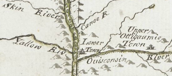
Click to Enlarge or visit the zoomable version at the Nicollet Project at St. Olaf College
The manuscript is also differs from the published map in that the placement of lakes, rivers, and portages. At first glance, to those of us used to Google and the modern highway system, to be less accurate in terms of actual fixed latitude and longitude. Instead, it seems more reflective of how Wisconsin’s geography would have been perceived at the time–as chains of water routes and portages. I need to look into it further, but my current understanding is that Nicollet did not travel extensively in Wisconsin. Therefore, one can assume that he got most of this information from his hired Ojibwe and Metis guides and voyageurs.

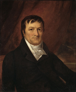
Zhagobe (Shakopee, Chagobai, Little Six), a Snake River chief worked with Nicollet and may have been an informant for the map. (Painting by Charles Bird King from James Otto Lewis portrait 1825 or 1826)
The handwritten map is challenging to read. Parts of it are ripped and faded, and the labels are oriented in all directions, including upside-down. Perhaps most difficult for me, as a monolingual English speaker, the map is in no fewer than four languages. French predominates, but there is a great deal of Ojibwe (especially in place names) and some English in descriptions. Near the mouth of the Chippewa River, there is another language, probably Dakota, but I don’t know Siouan languages well enough to say it is not Ho-Chunk.
After spending a few minutes with the map, I knew that the only way I would be able to engage with it fully would be to make it a project. So, I set out to reproduce the map, as faithfully as possible to the original, but with more legible text oriented according to more-modern cartographic conventions. Here is the result:

My hope is that the reproduction will make comparisons with the published map easier for scholars, or at the very least, provide a guide for working with the manuscript. However, this is where I’ll need help from readers, especially those who are good with Ojibwe and French grammar.
Here are some of the challenges we’re up against:


Familiarity of Locations
Being most familiar with the parts of Wisconsin within the Lake Superior basin, a map that focuses on the Mississippi watershed is not necessarily in my wheelhouse. Unfortunately, that’s what this truly is a map. Locations on the lakeshore are barely shown on the manuscript. There is far better detail in Nicollet’s published map showing that he must have used different sources to fill in that section of his finished product. However, because the Chequamegon area is the most ripped, faded, and difficult part to read on the entire map, familiarity was an asset. In the snippet on the left, I am fairly confident that the ripped part under “Chagwamigon” should read Long Ile ou Lapoint or something very similar. Whereas, the snippet on the right, showing the Eau Galle River area west of Eau Claire, has much clearer script, but I am far less confident in my transcription because I have not been able to locate any online references to Jolie Butte or Rhewash. Waga online. So, if there are any French or Dakota speakers out there who live near the mouth of the Chippewa let me know if there is a place called “Pretty Mound” or something similar and if I got my letters correct.
Colloquial Nouns in Poor Handwriting

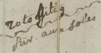
Readers of the blog know that I am a big fan of Google Translate. Compared with the early days of online translation, it is amazing how close one can to reading text in an unfamiliar language these days. No online translation is ever perfect, especially with grammar, but Google usually steers me in the right direction for nouns. That said, there are some problems. The French language, as translated by Google, is more or less the 20th-century version of what Nicollet was educated in. However, neither of those is the French that was spoken in this area. What European visitors called Patois and what Manitobans call Michif or Metis French is truly a language of its own and a product of the fur trade. The “French” of 19th-century La Pointe contained a great deal of Ojibwe and numerous archaic words from colonial Quebec. This can create challenges in translation, especially when the handwriting is ambiguous. The snippet on the left, for example, appears to be the Poplar River in Douglas County. However, the label doesn’t appear to say anything like peuplier or tremble (aspen). I played around with “frondes” or considered other river names entirely, until I stumbled across the word liard. Liard does not seem to have the meaning in modern French, but in colloquial Quebecois, it is regionally used to describe several different species of popple tree. Riv. aux Soles (right), however, has proved much more difficult. I initially saw the French name of the Totagatic as Riv. aux Lobes, but after some emails with Brian Finstad, Soles seems like the best guess. But, what is a Sole? Is it the sun? The bottom of a foot? A flounder? The same fish name can often be applied to different species in different regions. Is a sculpin a sole? Is a bullhead? Do we need to talk to old fishermen in Quebec to find out?
Lack of Grammatical Knowledge
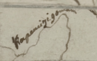
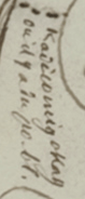
If Google Translate is my go-to place for French, the Ojibwe People’s Dictionary is where I go to try to confirm words in Ojibwe. Again, it’s great for nouns and verb-parts, but unless you speak these languages better than I do, knowing the gist of what the word means doesn’t mean you’ll get the translation right. In the snippet on the left, I transcribed the Ojibwe name for Cross Lake on the Snake River as Kapemijigonian. This word has elements of the meaning “flows through” in Ojibwe, but the word is nonsensical grammatically. Charles Lippert, who works for the Mille Lacs Band and has a wealth of information about Ojibwe linguistics, knew the real name, and was kind enough to offer Kapemijigoman as the correct transcription. Who knows how many similar errors could have been made? French can be tricky too. Mistaking ou for on, which is very possible with Nicollet’s handwriting, might not alter the meaning of a large chunk of text on Google Translate, but it sure can make you sound like a two-year old. Check out the snippet of French on the right. How can a non-Francophone read that?

I used the Inkscape vector graphics illustration program to trace the reproduction from the original.

As always, thanks for reading and please send feedback.
By Amorin Mello
A curious series of correspondences from “Morgan”
… continued from Copper Harbor Redux.

The Daily Union (Washington D.C.)
“Liberty, The Union, And The Constitution.”
August 29, 1845.
EDITOR’S CORRESPONDENCE.
—
[From our regular correspondent.]
ST. LOUIS, Mo. Aug. 19, 1845.
One of the most interesting sections of the North American continent is the basin of the Upper Mississippi, being, as it is, greatly diversified by soil, climate, natural productions, &c. It embraces mineral lands of great extent and value, with immense tracts of good timber, and large and fertile bodies of farming land. This basin is separated by elevated land o the northeast, which divides the headwaters of rivers emptying into the Mississippi from those that flow into the lakes Superior and Michigan, Green Bay, &c. To the north and northwest, it is separated near the head of the Mississippi, by high ground, from the watercourses which flow towards Hudson’s bay. To the west, this extensive basin is divided from the waters of the Missouri by immense tracts of elevated plateau, or prairie land, called by the early French voyageurs “Coteau des Prairies,” signifying “prairie coast,” from the resemblance the high prairies, seen at a great distance, bear to the coast of some vast sea or lake. To the south, the basin of the Upper Mississippi terminates at the junction of the Mississippi with the Des Moines river.
The portion of the valley of the Mississippi thus described, if reduced to a square form, would measure about 1,000 miles each way, with St. Anthony’s falls near the centre.
1698 detail of Saint Anthony’s Falls and Lake Superior from Amerique Septentrionalis Carte d’un tres grand Pays entre le Nouveau Mexique et la Mer Glaciace Dediee a Guilliaume IIIe. Roy de La Grand Bretagne Par le R. P. Louis de Hennepin Mission: Recol: et Not: Apost: Chez c. Specht a Utreght 1698.
~ Commons.Wikimedia.org
For a long time, this portion of the country remained unexplored, except by scattered parties of Canadian fur-traders, &c. Its physical and topographical geography, with some notions of its geology, have, as it were, but recently attracted attention.

Douglas Volk painting of Father Hennepin at Saint Anthony Falls.
~ Commons.Wikimedia.org

Father Antoine “Louis” Hennepin
~ Wikipedia.org
Father Hennepin was no doubt the first white man who visited St. Anthony’s falls. In reaching them, however, he passed the mouth of St. Peter’s river, a short distance below, without noticing it, or being aware of its existence. This was caused by the situation of an island found in the Mississippi, directly in front of the mouth of St. Peter’s, which, in a measure, conceals it from view.
After passing the falls, Father Hennepin continued to ascend the Mississippi to the St. Francis river, but went no higher.

Portrait of Jonathan Carver from his book, Travels through the interior parts of North America in the years 1766, 1767 and 1768.
~ Wisconsin Historical Society
In the year 1766, three years after the fall of Canada, Captain Johnathan Carver, who had taken an active part as an officer in the English service, and was at the surrender of Fort William Henry, where (he says) 1,500 English troops were massacred by the Indians, (he himself narrowly escaping with his life,) prepared for a tour among the Indian tribes inhabiting the shores of the upper lakes and the upper valley of the Mississippi. He left Boston in June of the year stated, and, proceeding by way of Albany and Niagara, reached Mackinac, where he fitted out for the prosecution of his journey to the banks of the Mississippi.
From Mackinac, he went to Green Bay; ascended the Fox river to the country of the Winnebago Indians; from thence, crossing some portages, and passing through Lake Winnebago, he descended the Wisconsin river to the Mississippi river; crossing which, he came to a halt at Prairie du Chien, in the country of the Sioux Indians. At the early day, this was an important trading-post between French traders and the Indians. Carver says: “It contains about three hundred families; the houses are well built, after the Indian manner, and well situated, on a very rich soil, from which they raise every necessary of life in great abundance. This town is the great mart whence all the adjacent tribes – even those who inhabit the most remote branches of the Mississippi – annually assemble about the latter end of May, bringing with them their furs to dispose of to the traders.” Carver also noticed that the people living there had some good horses.
Detail of Prairie du Chien from Carver [Jonathan], Captain. Journal of his travels with maps and drawings, 1766.
~ Boston Public Library
The fur-trade, which at one time centred here, and gave it much consequence, has been removed to St. Peter’s river. Indeed, this trade, which formerly gave employment to so many agents, traders, trappers, &c., conferring wealth upon those prosecuting it, is rapidly declining on this continent; in producing which, several causes conspire. The first is, the animals caught for their furs have greatly diminished; and the second is, that competition in the trade has become more extensive and formidable, increasing as the white settlements continue to be pushed out to the West.
John Jacob Astor established the American Fur Company.
~ Wikipedia.com
At Prairie du Chien is still seen the large stone warehouse erected by John Jacob Astor, at a time when he ruled the trade, and realized immense profits by the business. The United States have a snug garrison at this place, which imparts more or less animation to the scene. It stands on an extensive and rather low plain, with high hills in the rear, running parallel with the Mississippi.
The house in which Carver lodged, when he visited this place, is still pointed out. There are some men living at this post, whose grandfather acted as interpreter to Carver. The Sioux Indians, whom Carver calls in his journal “the Nadowessies,” which is the Chippewa appellation for this tribe of Indians, keep up the tradition of Carver’s visit among them. The inhabitants, descendants of the first settlers at Prairie du Chien, now living at this place, firmly believe in the truth of the gift of land made to Carver by the Sioux Indians.
From this point Carver visited St. Anthony’s falls, which he describes with great accuracy and fidelity, accompanying his description with a sketch of them.
![Detail of Saint Anthony's Falls from Carver [Jonathan], Captain. Journal of his travels with maps and drawings, 1766. ~ Boston Public Library](https://chequamegonhistory.com/wp-content/uploads/2016/05/carver-detail-of-st-anthony-falls.jpg)
Detail of Saint Anthony’s Falls from Carver [Jonathan], Captain. Journal of his travels with maps and drawings, 1766.
~ Boston Public Library
From the Mississippi river Carver crossed over to the Chippewa river; up which he ascended to its source, and then crossed a portage to the head of the Bois Brulé, which he called “Goddard’s river.” Descending this latter stream to Lake Superior, he travelled around the entire northern shore of that lake from west to east, and accurately described the general appearance of the country, including notices of the existence of the copper rock on the Ontonagon, with copper-mineral ores at points along the northeastern shore of the lake, &c.
![Detail of "Goddard's River," La Pointe, and Ontonagon from Carver [Jonathan], Captain. Journal of his travels with maps and drawings, 1766. ~ Boston Public Library](https://chequamegonhistory.com/wp-content/uploads/2016/05/carver-detail-of-goddard-river-and-la-pointe.jpg)
Detail of “Goddard River,” La Pointe, and Ontonagon from Carver [Jonathan], Captain. Journal of his travels with maps and drawings, 1766.
~ Boston Public Library
He finally reached the Sault St. Marie, where he found a French Indian trader, (Monsieur Cadot,) who had built a stockade fort to protect him in his trade with the Indians.
![Detail of Sault Ste Marie from Carver [Jonathan], Captain. Journal of his travels with maps and drawings, 1766. ~ Boston Public Library](https://chequamegonhistory.com/wp-content/uploads/2016/05/carver-detail-of-sault-ste-marie.jpg)
Detail of Sault Ste Marie from Carver [Jonathan], Captain. Journal of his travels with maps and drawings, 1766.
~ Boston Public Library
Descendants of this Monsieur Cadot are still living at the Sault and at La Pointe. We met one of them returning to the latter place, in the St. Croix river, as we were descending it. They, no doubt, inherit strong claims to land at the falls of the St. Mary’s river, which must ere long prove valuable to them, if properly prosecuted.
From the Sault St. Marie, Carver went to Mackinac, then garrisoned by the English, where he spent the winter. The following year he reached Boston, having been absent about two years.
From Boston he sailed for England, with a view of publishing his travels, and securing his titles to the present of land the Sioux Indians have made him, and which it is alleged the English government pledged itself to confirm, through the command of the King, in whose presence the conveyance made to Carver by the Sioux Indians was read. He not only signified his approval of the grant, but promised to fit out an expedition with vessels to sail to New Orleans, with the necessary men, &c., which Captain Carver was to head, and proceed from thence to the site of this grant, to take possession of it, by settling his people on it. The breaking out of the American revolution suspended this contemplated expedition.
Captain Carver died poor, in London, in the year 1780, leaving two sons and five daughters. I consider his description of the Indians among whom he travelled, detailing their customs, manners, and religion, the best that has ever been published.
In this opinion I am sustained by others, and especially by old Mr. Duncan Graham, whom I met on the Upper Mississippi. He has lived among the Indians ever since the year 1783. He is now between 70 and 80 years old. He told me Carver’s book contained the best account of the customs and manners of the Indians he had ever read.
His valuable work is nearly out of print, it being rather difficult to obtain a copy. It went through three editions in London. Carver dedicated it to Sir Joseph Banks, president of the Royal Society. Almost every winter on the Indians and Indian character, since Carver’s time, has made extensive plagiarisms from his book, without the least sort of acknowledgement. I could name a number of authors who have availed themselves of Carver’s writings, without acknowledgement; but as they are still living, I do not wish to wound the feelings of themselves or friends.
One of the writers alluded to, gravely puts forth, as a speculation of his own, the suggestion that the Winnebagoes, and some other tribes of Indians now residing at the north, had, in former times, resided far to the south, and fled north from the wars and persecutions of the bloodthirsty Spaniards; that the opinion was strengthened from the fact, that the Winnebagoes retained traditions of their northern flight, and of the subsequent excursions of their war parties across the plains towards New Mexico, where, meeting with Spaniards, they had in one instance surprised and defeated a large force of them, who were travelling on horseback.
Now this whole idea originated with Carver; yet Mr. ——— has, without hesitation, adopted it as a thought or discovery as his own!

Alexander Henry, The Elder.
~ Wikipedia.com
The next Englishman who visited the northwest, and explored the shores of Lake Superior, was Mr. Henry, who departed from Montreal, and reached Mackinac through Lake Huron, in a batteau laden with some goods. His travels commenced, I believe, about 1773-‘4, and ended about 1776-‘7. Mr. Henry’s explorations were conducted almost entirely with the view of opening a profitable trade with the Indians. He happened in the country while the Indians retained a strong predilection in favor of the French, and strong prejudices against the English. It being about the period of the Pontiac war, he had some hazardous adventures among the Indians, and came near losing his life. He continued, however, to prosecute his trade with the Indians, to the north and west of Lake Superior. Making voyages along the shores of this lake, he became favorably impressed with the mineral appearances of the country. Finding frequently, through is voyageurs, or by personal inspections, rich specimens of copper ore, or of the metal in its native state, he ultimately succeeded in obtaining a charter from the English government, in conjunction with some men of wealth and respectability in London, for working the mines on Lake Superior. The company, after making an ineffectual attempt to reach a copper vein, through clay, near the Ontonagon, the work was abandoned, and was not afterwards revived.
General Cass, with Colonel Allen, &c., were the next persons to pass up the southern coast of Lake Superior, and, in going to the west and northwest of the lake, they travelled through Indian tribes in search of the head of the Mississippi river. Their travels and discoveries are well known to the public, and proved highly interesting.
Mr. Schoolcraft’s travels, pretty much over the same ground, have also been given to the public; as also the expedition of General Pike on the Upper Mississippi.

Major Stephen Harriman Long published his expedition as Voyage in a Six-oared Skiff to the Falls of St. Anthony in 1817.
~ Wikipedia.org
More lately, the basin of the Upper Mississippi has received a further and more minute examination under the explorations directed by Major Long, in his two expeditions authorized by government.

Joseph Nicholas Nicollet
~ Wikipedia.org
Lastly, Mr. J. N. Nicollet, a French savan, travelling for some years through the United States with scientific objects in view, made an extensive examination of the basin of the Upper Mississippi.
He ascended the Missouri river to the Council Bluffs; where, arranging his necessary outfit of men, horses, provisions, &c., (being supplied with good instruments for making necessary observations,) he stretched across a vast tract of country to the extreme head-waters of the St. Peter’s, determining, as he went, the heights of places above the ocean, the latitude and longitude of certain points, with magnetic variations. He reached the highland dividing the waters of the St. Peter’s from those of the Red river of the North. He descended the St. Peter’s to its mouth; examined the position and geology of St. Anthony’s falls, and then ascended the same river as high as the Crow-wing river. The secondary rock observed below the falls, changes for greenstone, sienite, &c., with erratic boulders. On the east side of the river, a little below Pikwabik, is a large mass of sienitic rock with flesh-colored feldspar, extending a mile in length, half a mile in width, and 80 feet high. This is called the Little Rock. Higher up, on the same side, at the foot on the Knife rapids, there are sources that transport a very fine, brilliant, and bluish sand, accompanied by a soft and unctuous matter. This appears to be the result of the decomposition of a steachist, probably interposed between the sienitic rocks mentioned. The same thing is observed at the mouths of the Wabezi and Omoshkos rivers.
Detail of Saint Anthony’s Falls and Saint Peter’s River from Hydrographical Basin of the Upper Mississippi River from Astronomical and Barometrical Observations Surveys and Information by Joseph Nicolas Nicollet, 1843.
~ David Rumsey Map Collection
Ascending the Crow-wing river a short distance, Mr. Nicollet turned up Gull river, and proceeded as far as Pine river, taking White Fish lake in his way; and again ascended the east fork of Pine river, and reached Little Bay river, which he descended over rapids, &c., to Leech lake, where he spent some days in making astronomical observations, &c. From Leech lake, he proceeded, through small streams and lakes, to that in which the Mississippi heads, called Itasca. Having made all necessary observations at this point, he set out on his return down the Mississippi; and finally, reaching Fort Snelling at St. Peter’s, he spent the winter there.

Detail of Leech Lake and Lake Itasca from Hydrographical Basin of the Upper Mississippi River from Astronomical and Barometrical Observations Surveys and Information by Joseph Nicolas Nicollet, 1843.
~ David Rumsey Map Collection
Lake Itasca, in which the Mississippi heads, Mr. Nicollet found to be about 1,500 feet above the level of the ocean, and lying in lat. about 47° 10′ north, and in lon. 95° west of Greenwich.
This vast basin of the Upper Mississippi forms a most interesting and valuable portion of the North American continent. From the number of its running streams and fresh-water lakes, and its high latitude, it cannot fail to prove a healthy residence for its future population.
It also contains the most extensive body of pine timber to be found in the entire valley of the Mississippi, and from which the country extending from near St. Anthony’s falls to St. Louis, for a considerable distance on each side of the river, and up many of its tributaries, must draw supplies of lumber for building purposes.
In addition to these advantages, the upper basin is rich in mines of lead and copper; and it is not improbable that silver may also be found. Its agricultural resources are also very great. Much of the land is most beautifully situated, and fertile in a high degree. The climate is milder than that found on the same parallel of latitude east of the Alleghany mountains. Mr. Nicollet fixes the mean temperature at Itasca lake at 43° to 44°; and at St. Peter’s near St. Anthony’s falls, at 45° to 46°

“Maiden Rock. Mississippi River.“ by Currier & Ives. Maiden’s Rock Bluff. This location is now designated as Maiden Rock Bluff State Natural Area.
~ SpringfieldMuseums.org
Every part of this great basin that is arable will produce good wheat, potatoes, rye, oats, Indian corn to some extent, fine grasses, fruits, garden vegetables, &c. There is no part of the Mississippi river flanked by such bold and picturesque ranges of hills, with flattened, broad summits, as are seen extending from St. Anthony’s falls down to Prairie du Chien, including those highlands bordering Lake Pepin, &c. Among the cliffs of sandstone jutting out into perpendicular bluffs near the river, (being frequently over 100 feet high,) is seen one called Maiden’s rock. it is said an Indian chief wished to force his daughter to marry another chief, while her affections were placed on another Indian; and that, rather than yield to her father’s wishes, she cast herself over this tall precipice, and met an instant death. On hearing of which, her real lover, it is said, also committed suicide. Self-destruction is very rare among the Indians; and we imagine, when it does occur, it must be produced by the strongest kind of influence over their passions. Mental alienation, if not entirely unknown among them, must be exceedingly rare. I have no recollection of ever having heard of a solitary case.
From St. Anthony’s falls to St. Louis is 900 miles. The only impediment to the regular navigation of the river by steamboats, is experienced during low water at the upper and lower rapids.
“St. Louis Map circa 1845”
~ CampbellHouseMuseum.org
The first are about 14 miles long, with a descent of only about 25 feet. The lower rapids are 11 miles long, with a descent of 24 feet. In each case, the water falls over beds of mountain or carboniferrous limestone, which it has worn into irregular and crooked channels. By a moderate expenditure of money on the part of the general government, which ought to be made as early as practicable, these rapids could be permanently opened to the passage of boats. As it is at present, boats, in passing the rapids at low water, and especially the lower rapids, have to employ barges and keel-boats to lighten them over, at very great expense.
From the rapid settlement of the country above, with the increasing trade in lumber and lead, the business on the Upper Mississippi is augmenting at a prodigious rate. When the river is sufficiently high to afford no obstruction on the lower rapids, not less than some 28 or 30 boats run regularly between Galena and St. Louis – the distance being 500 miles. Besides these, two or three steam packets run regularly to St. Anthony’s falls, or to St. Peter’s, near the foot of them. Every year will add greatly to the number of these boats. Other fine large and well-found packets run from St. Louis to Keokuk, at the foot of the lower rapids, four miles below which the Des Moines river enters the Mississippi river. It is the opinion of Mr. Nicollet, that this river can be opened, by some slight improvements, for 100 miles above its mouth. It is said the extensive body of land lying between the Des Moines and the Mississippi, and running for a long distance parallel with the left bank of the latter, contains the most lovely,rich and beautiful land to be found on the continent, if not in the world. It is already pretty thickly settled. Splendid crops of wheat and corn have been raised on farms opened upon it, the present year. Much of the former we found had already arrived at depots on the river, in quantities far too great to find a sufficient number of boats, at the present low water, to carry it to market.
I do not see but the democratic party are regularly gaining strength throughout the great West, as the results of the recent elections, which have already reached you, sufficiently indicate.
Those who wish to obtain more general, as well as minute information, respecting the basin of the Upper Mississippi, I would recommend to consult the able report, accompanied with a fine map of the country, by Mr. J. N. Nicollet, and reprinted by order of the Congress at their last session.
I am, very respectfully,
Your obedient servant,
MORGAN.
This curious series of correspondences from “Morgan” is continued in the September 1 and September 5 issues of The Daily Union, where he arrived in New York City again after 4,200 miles and two and a half months on this delegation. As those articles are not pertinent to the greater realm of Chequamegon History, this concludes our reproduction of these curious correspondences.
The End.
Wisconsin Territory Delegation: Saint Croix Falls
April 28, 2016
By Amorin Mello
A curious series of correspondences from “Morgan”
… continued from La Pointe.
The Daily Union (Washington D.C.)
“Liberty, The Union, And The Constitution.”
August 27, 1845.
EDITOR’S CORRESPONDENCE.
—
(From our regular correspondent.)
FALLS, ST. CROIX, W. T., Aug. 7, 1845.
We left La Pointe on the afternoon of the day on which my last letter was dated. We had about 70 miles (English,) or 63 of French voyageur’s miles, to travel westward on the lake, before reaching the Brulé river, which we were to ascend for 75 miles, to make the portage to the St. Croix; the latter river being, from its source to the Mississippi river, including the Lake St. Croix at its mouth, about 300 miles long – thus making a journey before us of about 445 miles to reach the Mississippi. To La Pointe we had already coasted from Sault St. Marie, including the curves, bends, bays, &c , with the entire circuit of Keweena point, the distance of at least 500 miles. The two added together, give 945 miles of travel, in open boats by day, and under tents by night, with the exception of the three miles portage between the two rivers. We left the Sault on the 4th July, and reached this place within 50 miles of the Mississippi, making the whole time consumed one month and about three or four days, by the time we will have reached the “father of waters.”

Detail of the shoreline between La Pointe and the Bois Brulé River from Map of the Mineral Lands Upon Lake Superior Ceded to the United States by the Treaty of 1842 With the Chippeway Indians.
~ Wisconsin Historical Society
The distance, in a direct line, from the head of the bay opposite La Pointe, to the portage at the head of the Brulé, by land, is only 80 miles; while by the lake and river, it is about 145. The whole distance, in a direct line, by land, from La Pointe to the falls of St. Anthony, or to the mouth of the St. Peter’s, does not exceed, by the Indian trail alluded to, over 200 miles.
The first day we left La Pointe we were only enabled to reach Raspberry river, a small stream emptying into the lake 15 miles west of La Pointe, inside the group of islands.
We first encountered a prodigious thick fog, with a head wind. We had no sooner landed and raised our tent, than a thunder-storm, with a heavy rain, burst upon us. The voyageurs, as is their custom, had puled the bark canoes out of the water, and turned them over, placing provisions and other articles under them for shelter. The Indians, in travelling with their canoes, invariably pull them out of the water at night, turn them bottom upwards, and in bad weather, sleep under them; as our voyageurs (especially Jocko, our Indian voyageur) did on the night in question. In such cases, they turn water like the roof of a house. We had, late in the afternoon, doubled some frowning sandstone cliffs alluded to in my other letter, with the grottoes, caves, and excavations wrought out near the water’s edge, by the combined action of the waves and frost. Another high sandstone promontory still lay just ahead of us, which Ribedoux, our head man, said extended for six miles without affording a landing-place for a boat.
Next morning we found a severe gale blowing from the north-northeast, accompanied with rain. This compelled us to remain where we were till about 3 or 4 o’clock in the afternoon, when we set out. The wind had died away, but the sea was running very high, over which our canoes danced along at a great rate – riding them, however, like swans. The heaviest rolls would be mounted and slid over with as much ease as though the canoes were feathers, as they were propelled forward by the oars and paddles of our skillful voyageurs.
One canoe being small, only admitted of the use of paddles. The larger craft allowed a pair of oars to be used in front, while a paddle was employed in the stern. The usual plan of working canoes is to have only two persons to attend to one canoe. They are always steered with a paddle. One voyageur seats himself in the bow; while another does the same thing in the stern – the baggage, provisions, passengers, &c., being stored amidships, low in the hull. Thus arranged, the men apply their paddles with great skill, driving the canoe forward at a pretty rapid speed.
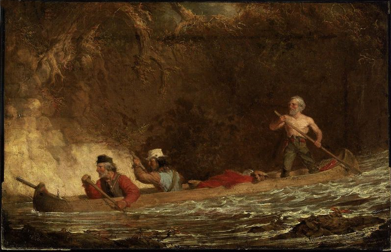
The Voyageurs by Charles Deas, 1846.
~ Commons.Wikimedia.org
The Indians display a deal of skill in the construction of their bark canoes. Their hulls have great symmetry of form; and, under careful handling, which the Indians perfectly understand and practise, they are very light and very strong.
The birch bark, from which they are principally made, is found of excellent quality on the shores and tributaries of Lake Superior, and is extensively used by the Indians for building their lodges, &c., as well as for canoes. In the latter application, the inside of the bark is exposed to the water and weather; while, in the former case, the outside of the bark is turned to the weather. Their lodges are of a hemispherical shape, with an opening at the top for the escape of smoke, with a door opening on one side of them, before which a blanket is usually suspended. The floor of the lodge, with the wealthier class, is usually covered with fine large richly-colored rush mats, on which the Indians recline or sit like Turks on them. The men, when at home, do little else than recline on the mats and smoke, while the squaws and half-grown children perform all the necessary manual labor. If an Indian brings in game or fish, he throws it down near his lodge, and troubles himself no more about it; or, if it be troublesome to carry, he leaves it in the woods, returns to the lodge, and sends his squaw for it.
The females among the Indians invariable exhibit the most modest and retiring deportment – equally as much so, I have thought, as is seen or met with among the most civilized whites. Neither males nor females, when you enter their villages or lodges, ever fix upon you that rude glare, or gaze, which white people often do upon the sudden appearance of a stranger. The usual salutation of the Chippewa, on meeting you, is “Bojour, bojour, bojour,” at the same time extending his hand to you in friendship. And if there are fifty men in company, they will all do the same thing. The exclamations they use is a corruption of the French salutation of “bon jour,” “good day;” or, in English parlance, “how d’ye do.”
The Indians are very fond of bathing and swimming, and they do not consider it the least indelicate for all sexes to bathe at the same time in the immediate vicinity of each other. I am told, on such occasions, the females wear dresses prepared for the purpose. The men also are partly clad.
“There are indications that Granville served as a teacher in a school unrelated to ABCFM on or near the Mackinaw Island from the fall of 1834 to the fall of 1835. His first connection with ABCFM dates from September 1835, and he was officially appointed by ABCFM as a missionary assistant some time in 1836. Granville took a leave between July 1837 and June 1838, then returned to La Pointe with his newly wed wife, Florantha nee Thompson. After one unsuccessful pregnancy, Florantha had two healthy daughters, in October 1842, and March 1844. Granville and Florantha retired from the mission in the summer of 1846.”
~ The Sproats at La Pointe: From pages of the Missionary Herald, Boston
I was told by Mr. Grote, who has resided at the Presbyterian mission at La Pointe for some 10 or 12 years, that the Indians, during long peace, and when little surrounds them of a nature to arouse or excite their energies, become, in general, very lethargic, and sink apparently (from ennui) into premature old age, few of them attaining to the years of advanced life. Among the chiefs I saw at La Pointe, was an old man of sixty. His hair was quite gray. He was introduced to me by a friend, at his own request. He wanted to know where I was from, and whether I had been sent to carry off the Indians. He was told that I had come on no such errand, but merely to visit and see the country, and that I was a “medicine man,” a “mushkiwinini:” this announcement put me on a very friendly footing with him. He bore a strong resemblance to Robert Dale Owen, the lecturer.
I was told by Mr. Grote that this old chief retained very strong predilections in favor of the British; that he frequently spoke of the good old times when they received fine presents and cheap goods from their great father, the King over the water; and that he annually paid a visit to the Hudson Bay Company’s trading-post at Fort William, or at the Sault, and received presents to some small amount. he nevertheless professed much friendship for the Americans.

“Mainland sea caves from the water.”
~ Apostle Islands National Lakeshore
We left Raspberry river between 3 and 4 p.m., and passed one among the most picturesque cliffs of sand-stone it was our lot to see during the voyage. It spread along the shore for 6 or 7 miles, varying in height from 50 to 100 feet. Its base was carved into holes and grottoes of every variety of form, into which the heavy rolls of the waves were pitching with a rumbling and heavy sound; while the white spray flew in foaming whiteness about the outward rocks. Making a beach near dark at the bottom of the bay, beyond the cliffs, we landed and camped. Early next morning we were again under way. In the afternoon we passed four Indian canoes loaded with Indians bound for La Pointe. They were from Fond-du-Lac.
Making Cranberry river, we found Capt. Stanard and his party of voyageurs, who had preceded us from La Pointe, and were bound for Fond-du-Lac, had stopped for dinner. We concluded to land at the same place for the same purpose.
We were told by Capt. S that he had, on his way, visited an encampment of Indians from Fond-du-Lac, who stated that the Chippewas at that place were laboring under a good deal of excitement. It seemed that two Indians of that place had been on a visit to the falls of St. Croix, where liquor was freely sold to the Indians; that one of the Indians and a white man quarrelled about a dog; that the latter mauled and beat the former most unmercifully, when the other Indian attempted to interfere, whom the white man attacked and commenced beating also. The last Indian thereupon stabbed the white man in the breast with a knife, the point of which struck a bone and glanced. The white man then drew a pistol, and fired it at the Indian, wounded him severely in the thigh. The Indians then left the falls, and returned to Fond-du-Lac highly incensed, and swearing vengeance against the whites; saying their relations numbered thirty warriors, who would aid them, if necessary, in seeing justice done. They also said that, some time ago, a Sioux Indian had killed a Chippewa, and that the whites did nothing with him for it. When the brother of the deceased Chippewa went over to St. Peter’s, and killed the Sioux, the whites had taken up two Chippewas, and had them in jail, which they thought very hard of. It was also said that sometimes, when the Chippewas left their homes to go to the payment, the Sioux followed them, with a view of annoying and harassing them in the rear.
Captain S. said that he had intended to visit the falls of the Brulé, to fish for trout; but that, owing to these reported difficulties, he should proceed directly to Fond-du-Lac. It seems that the whole foundation of the troubles on the St. Croix, with the Chippewas, has grown out of the circumstance of grog-shops having been opened at different places along that stream – say one at the falls, another at Wolf river, eighteen or twenty miles above, and a third at the Rising Sun, twenty-five miles above the falls – by low and villanous white men, or half-breeds engaged in their service. It seems that, some years since, the Chippewas made a treaty, ceding all their lands to the United States, south of a line running due south some fifty miles from the extreme west end of Lake Superior, and from that southern point due west to the mouth of Crow-wing river, on the Upper Mississippi, cutting nearly through the centre of Mille Lake in its course. There is a proviso in the treaty of cession, which authorizes the Indians to remain in the occupancy of the ceded territory till it is wanted by the government. I understood Mr. Hays (the Indian agent at La Pointe) to say that he had no power to stop the sale of ardent spirits to the Indians, by the white squatters in the ceded country. These drunken outrages, if not put a stop to on the St. Croix, will, ere long, lead to serious and disastrous consequences. The Indians and whites will soon become embroiled in a border “guerrilla” war, and the poor savages, in the end, be butchered and driven out of the country – all, too, growing out of the cupidity of a few rascally men, who aim to cheat and rob the Indians of their last blanket, by selling them the hellish poison of whiskey. What is the massacre of innocent whites, with the ruin and degradation of Indians, to them, provided they can turn a penny by dealing out rum!! Mr. Hays lives almost too remote from the St. Croix to prevent these outrages, even if he had the power. But it does seem to me, that the Indian agent at St. Peter’s, who resides within a day or two’s journey of these outrages, might do something to prevent them.
With due vigilance and firmness on his part, it would appear probable, at least, that Indian murders would not transpire within gun-shot of his agency at St. Peter’s.
The War Department should adopt immediate measures to break up the sale of whiskey to the Indians on the St. Croix, and other parts of that ceded territory, or very serious consequences will follow. One poor Indian from Fond-du-Lac, on a visit to one of the grogeries on the St. Croix, was made beastly drunk, who, in his helplessness, fell with his face on the fire; having his cheek, with one eye, awfully disfigured and burnt; leaving his whole visage an object of loathing and disgust for life.
As our course to the Mississippi lay along the St. Croix, directly through the whiskey district, the reports of present and prospective difficulties were not very pleasant. We nevertheless made up our minds to persevere, and meet whatever might happen.
Negwanebi (Quill)
Wazhashkokon (Muskrat’s Liver, aka Pítad in Dakota);
Noodin (Wind).
Towards sunset, we made the mouth of the Brulé, where we found about thirty Chippewa Indians with two or three chiefs encamped, who were on their way to La Pointe; from Leech Lake and Mille Lake. They belonged to the band denominated “pillageurs,” so nicknamed from their alleged propensity to steal small matters. We landed on the opposite side of the river to their camp, on a flat – the stream being about twice as wide as the Tiber in good water at Washington. We were soon joined by Captain Stanard, whose men pitched his tent near ours, and cooked supper by the same fire. We had scarcely kindled our camp fire, before the chiefs of the “pillageurs” manned their canoes, and came over, crying out, as they came up; “Bojour,” “bojour,” and giving us their hands, which we accepted. They looked poor and dirty, some of whom were nearly naked. They said they had nothing to eat, and were very hungry, and wished us to give them some flour, which we complied with. No sooner did the rest find out we were dispensing “farine,” as the French voyageurs term it, than the whole [posse?] kept coming over in instalments, till we had the whole camp upon our hands – women, children, and all.
We gave them all round about a pint of flour, from Captain S.’s and our own supply, and then gave them to understand we wished them to retire to their own side of the river; they all left us, except some old chiefs, who were privileged to remain, and appeared desirous of smoking their pipes before our fire, and talking over news with Jocko, our Indian voyageur, and one of Captain S.’s half-breeds.
In their camp opposite – out of joy, I suppose, over the flour we had given them – they commenced beating a drum, and singing in a most wild and monotonous manner, which they kept up till near ten p.m., when all became silent. We all fell fast asleep; and when I awoke next morning, calling the hands for an early start, all was quiet in the Indian camp. Captain Stanard prepared to depart at the same time, and before sunrise he was off to Fond-du-Lac, and we to the Mississippi. Whatever the “pillageurs” may have done elsewhere, we will do them the justice to say that they stole nothing from us; for next morning, on packing up, we missed nothing whatever. Many of them had pleasing and honest countenances, whatever else may be said about them.

Detail of the Bois Brulé River (aka “Wissakude [Wisakoda] or Burnt Wood”) and the portage over the Great Divide (a continential divide between the Lake Superior Basin and Missisippi River Basin) to the Saint Croix River from Hydrographical Basin of the Upper Mississippi River from Astronomical and Barometrical Observations Surveys and Information by Joseph Nicolas Nicollet, 1843.
~ David Rumsey Map Collection
At many places the rapids were so powerful, and the channel so crooked and narrow, that the voyageurs had to wade in the water frequently to their waist, and push the canoes forward with their hands. Sometimes their feet would slip from the spurs of trap-rock boulders, and they would go into holes of deep water, nearly to their arm-pits or chins.
We worked forward in this way over rapids, for about thirty miles; and having passed three portages, around which we had to walk and carry our baggage, with still the fourth and last severe one before us, we finally struck up a camp near the head of the third portage, where all were sufficiently fatigued to sleep most soundly. At this last portage rapid, there appeared in the bottom of the river a mass of trap crossing it, over which the water fell two or three feet nearly perpendicular.
We were off next morning early, after having examined the bottoms of our canoes, and patched and gummed the leaky places with birch bark and Canada balsam-tree rosin. The small canoe had to be patched and pitched two or three times, having been punched with holes by the rocks.
“In consideration of the cession aforesaid, the United States agree to make to the Chippewa nation, annually, for the term of twenty years, from the date of the ratification of this treaty, the following payments.
1. Nine thousand five hundred dollars, to be paid in money.
2. Nineteen thousand dollars, to be delivered in goods.
3. Three thousand dollars for establishing three blacksmiths shops, supporting the blacksmiths, and furnishing them with iron and steel.
4. One thousand dollars for farmers, and for supplying them and the Indians, with implements of labor, with grain or seed; and whatever else may be necessary to enable them to carry on their agricultural pursuits.
5. Two thousand dollars in provisions.
6. Five hundred dollars in tobacco.
The provisions and tobacco to be delivered at the same time with the goods, and the money to be paid; which time or times, as well as the place or places where they are to be delivered, shall be fixed upon under the direction of the President of the United States.
The blacksmiths shops to be placed at such points in the Chippewa country as shall be designated by the Superintendent of Indian Affairs, or under his direction.
If at the expiration of one or more years the Indians should prefer to receive goods, instead of the nine thousand dollars agreed to be paid to them in money, they shall be at liberty to do so. Or, should they conclude to appropriate a portion of that annuity to the establishment and support of a school or schools among them, this shall be granted them.”
“Whereas the whole country between Lake Superior and the Mississippi, has always been understood as belonging in common to the Chippewas, party to this treaty; and whereas the bands bordering on Lake Superior, have not been allowed to participate in the annuity payments of the treaty made with the Chippewas of the Mississippi, at St. Peters July 29th 1837, and whereas all the unceded lands belonging to the aforesaid Indians, are hereafter to be held in common, therefore, to remove all occasion for jealousy and discontent, it is agreed that all the annuity due by the said treaty, as also the annuity due by the present treaty, shall henceforth be equally divided among the Chippewas of the Mississippi and Lake Superior, party to this treaty, so that every person shall receive an equal share.”
Towards noon, we began to find the rapids less frequent and difficult, till we finally came into a beautiful low bottom, or meadow land, of elm trees, which lasted us for many miles; when, towards night, we again passed some severe rapids, and then entered a long lake of irregular width, formed by the expansion of the river at this point – in no case being more than from seventy-five to one hundred yards wide, with generally a swamp on one side, and considerable sloping pine hills or bluffs on the other. We found this river, and especially the lake part of it, to be very full of brook trout, some of which we caught, and found them not only beautiful in color, but most excellent to eat; they were continually jumping above the water. During this day and yesterday, we met several parties of half-breeds and Indians on their way to La Pointe. On inquiring of them about the fight at the falls, and the difficulties at St. Peter’s, they gave us the most favorable accounts of the quiet and peaceful disposition of the Indians, and said that we might travel just where we pleased, without the least danger whatever. At any rate, there was one guarantee of their good conduct for a few weeks to come – and that was the forthcoming payment at La Pointe, to which they go up with as much eagerness as the Jews of old did to the Passover. Any serious disturbance at the present time, or probably at any time, would jeopard the receipt of their annuity, and likely lead to their expulsion from the country. Besides, at the payment they have an opportunity of laying their numerous grievances before the father, who has to promise them to speak for them in the ear of the great father at Washington. So matters progress from one year to another, till many grievances of a minor or trivial nature are forgotten.
We camped on a sloping pine ridge, on the east side of the lake part of the river, about 7 p.m. We found all the nights on the Brulé cool and pleasant. The water throughout we found as cold as the best mountain spring-water.
We continued our ascent at an early hour next morning, and by noon found our little stream very much diminished in size and volume of water, dwindling first into a small creek, and afterwards into a mere meadow-brook, nearly choked up by the hanging and interlocked alder bushes, the limbs of which we had to push out of our way to enable us to pass. The little river on this swampy meadow-land also became very crooked. In going a mile, we very often had to traverse the meadow nearly a dozen times.

“Recreation of a voyageur carrying two 90 lb packs of fur across a portage to avoid rapids or move to another river.”
~ Saint Croix National Scenic Riverway
About half-past 2 p.m., however, we arrived at the portage, or the place where we were to take our canoes out, transport them, and afterwards their contents, on our backs, across hill-sides, and over the summit of one or two pine, sand, and pebble hills, about one hundred and fifty feet above the level of the swamp in which the St. Croix and Brulé head. The two rivers are said to have a common origin in one spring. But the swamp, in which they both head, is no doubt full of springs – some running one way and some running another. This swamp is wide, extending from one river to the other, nearly north and south. On the east side of this swamp, and parallel with it, are found the range of pine hills by the sides, and over the summits of which the portage path crosses. Still to the east of this short range of hills, is a small lake, which empties into the river Brulé at some distance below the portage, called by the voyageurs White-fish lake. Near the head of streams of the St. Croix river is Upper St. Croix lake, to which our portage path descended at the northeast corner, descending to it down the southern side of the hills spoken of, being three miles from the place of debarkation on the Brulé. The sources of these rivers are laid down in Mr. Nicollet’s map as being nine hundred feet above the Atlantic. They are also said to be two hundred and seventy-five feet above the level of the lake; but I am inclined to believe that they are higher than stated – especially so above the level of the lake, if the high land we crossed be included in the estimate. Most of the maps are in error about the geography of this part of the country, both with regard to the heading of the rivers; as well as to their size and course.
The course of the Brulé is from south-southeast to north-northwest from the portage to the lake, being comparatively a small river. The course of the St. Croix, from its head to the Mississippi is south-southwest, and is by no means so crooked low down as represented. It is so large, for fifty or seventy-five miles above the falls, as to compare very favorably with the Ohio; which, at some points, it much resembles. It, and its tributaries, have a deal of fine pine timber growing along its banks; a good deal of which has been cut, to supply the mills below. Mr. Nicollet’s map, which is generally very correct, lays down hills between the waters of the Brulé and St. Croix, where none exist. I believe he did not visit the portage in person, but relied on the information of voyageurs.
It was an agreeable reflection to know, when standing on the highest point of hills on the portage, that we could overlook the course of one river sweeping away to the north, on its vast journey to the Gulf of the St. Lawrence; while to the south were seen the waters of the St. Croix, just gathered into a pretty, quiet lake, from its conglomerate of springs near by about to speed its waters to the Mississippi, and down it to the Gulf of Mexico! and when once there, perchance, gathered in the Gulf stream, and be again wafted by it to the banks of Newfoundland, where it may again unite with the water of its kindred Brulé!
What a wonderful continent is this of ours! What cast rivers and lakes intersect it! To appreciate their lengths, magnitude, scenery, &c., they must be travelled over to be understood. In June, I was at the Falls of Niagara; in a few days I shall probably be at the Falls of St. Anthony – passing from one to the other by water, with the exception of three miles!
Having, on August the 2d, succeeded in getting everything over the portage, including canoes, luggage, &c.; and it being towards sundown; we concluded to camp, and get ready for an early start next morning. Sunday morning, the 3d of August, found us descending the beautiful upper lake St. Croix, bordered in the distance with rolling pine-hills.
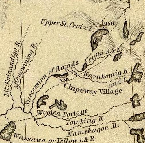
Detail of the upper Saint Croix River, Brule Bog portage, and “Chipeway Village” from Hydrographical Basin of the Upper Mississippi River From Astronomical and Barometrical Observations Surveys and Information by J.N. Nicollet, 1843. Also shown is the Grand Footpath (long dotted line) between Chequamegon Bay and Saint Anthony Falls.
~ David Rumsey Map Collection
We soon began to meet large parties of Indians in their canoes, bound to La Pointe, to be present at the payment. As Mr. Hays (the Indian agent at La Pointe) had told us that he expected the Rev. Mr. Ely, who had charge of a Presbyterian missionary station on the Percagaman, or Snake river, to be over at the payment, and thought it probable that we might meet him; and learning that some of the Indians we met were from Snake river, I asked them if they knew whether Mr. Ely had left. They told me he had, and that he was at his camp down the river, which we would soon reach.
We continued on, amidst fields of wild rice in full bloom, which covered the lake for acres upon acres on each side of the channel. This wild rice (rizania aquatica) is of great importance to the Indians, who gather large quantities of it when ripe, in autumn, for their winter food. Its soft stem and watery roots are immersed about 2 to 2½ feet under water, while the blades, head, and stalk reach about a foot to a foot and a half above water. In flowering, its heads present a singular appearance. Its pistils, or grain part of the flower, are clustered on a long, sharp-pointed spicular, terminating in a sharp cone at the very head of the stalk; while the pollen appears attached to the stalk below the head.
Why could not this rice be sown and cultivated in the lakes of western New York and in New England? Besides the value of the grain for poultry and various other purposes, its tops or blades would make the richest and sweetest fodder for cattle. I chewed the blades, and found them tender, and as sweet as the tender blades of green corn. The experiment might be worth the trial.

Reverend Edmund Franklin Ely.
~ Duluth Public Library
About the middle of the afternoon we reached the first rapids in descending the St. Croix, now contracted from a lake into a narrow river, strewed here and there with black boulders of trap. We here had the pleasure of finding Mr. Ely encamped on the west bank of the river, who had remained still all day, as it was Sunday. He had in company with him the Rev. Mr. Rosselle, a young clergyman from Ogdensburg, New York, to whom he introduced me. Mr. Rosselle informed me that he had been to the falls of St. Anthony, from whence he had gone on a steamboat “Still-water,” at the head of the lower Lake St. Croix, and from thence to the missionary station on the Pergacaman, or Snake river, where he concluded to accompany the Rev. Mr. Ely to La Pointe, and be present at the Indian payment. From La pointe he expected to make his way home by the Sault St. Marie, Mackinac, &c. Mr. Ely had some Indians along with him, who were evidently attached to the mission. He said the success of the mission had been interfered with, to some extend, by the dread in which the Chippewas held the Sioux in that part of the country; that in constant fear of their natural enemy, they disliked making permanent settlements and to improve them. After some other general conversation, we continued our journey over rapids, till near night, when we camped (as was often the case) on an old Indian camping-ground, and saw lying about us dog bones, on the meat of which the Indians had feasted. An innumerable swarm of horseflies surrounded our tent and camp-fire, which the voyageurs at first mistook for bumble bees, whose nest, they conceived, they had disturbed, and, for fear of being stung, they fled; but, on ascertaining they were merely noisy flies, they came back again.
We made an early start next morning, to resume our descent over rapids dashing over trap and granite boulders. We met a half-breed and his wife, who had a keg of whiskey in his canoe. They were going to La Pointe, where Mr. Hays suffers no liquor to land. The man offered to treat my voyageurs, one of whom was known to him. I consented that they might take one dram each, but no more. This being given them, we thanked him, and proceeded on our journey. About noon, we passed the last severe rapids, and the mouth of a large tributary from the east, called the Macagon, about 100 miles above the falls, and within 50 miles of Snake river.

Detail of the Saint Croix River with tributaries Snake River and Kettle River from Hydrographical Basin of the Upper Mississippi River From Astronomical and Barometrical Observations Surveys and Information by J.N. Nicollet, 1843. Also shown is the Grand Footpath (long dotted line) between Chequamegon Bay and Saint Anthony Falls.
~ David Rumsey Map Collection
The St. Croix, from this point down, became a larger, more beautiful, and more interesting stream. The bottoms, too, became wide and rich, but subject to inundation at very high water. The stratified red sandstone was seen to skirt the margins of the river, all along the rapids; while boulders of trap and granite were strewn over the centre of the channel. But, as we approached Kettle and Snake rivers, we began to notice the appearance of white sandstone on the shores of the river, which continued to appear till near the falls, and again rose in high cliffs below them, and continued to the Mississippi. At night, we camped on a high pine bluff on the right bank of the river, a large swamp being on the opposite side. Here we were nearly devoured by mosquitoes, and were glad to make our escape next morning without breakfast – intending to stop and cook at a place, if possible, less infested by them; which we did, on the pebbly beach of an island.
We had a showery forenoon, but continued our journey. We met with several long rapids, and, passing Kettle river, reached the mouth of Snake river, about 10 a.m. – where we found a body of Indians encamped, going to La Pointe. We exchanged some meal for some fish, and gave an old woman some sugar for a sick child. Then, wishing them a “bon voyage,” we put off. About 25 miles above the falls, we passed Sunrise river, with splendid and extensive bottom-land opposite to it on the left bank, lying high and dry above high-water mark.
The next place we made was Wolf river, about 18 or 20 miles above the falls. Here we found a rude village, on a rich piece of land, settled by half-breeds, Indians, and a Frenchman or two. They had lots of liquor, and offered to sell me some; but I declined to purchase, or to let my voyageurs buy any; and, though late in the afternoon, moved for some 8 or 10 miles further, and camped just within the first rapid or two, at the commencement of the falls. From the head of the rapids to the falls is 9 miles.

Detail of Saint Croix Falls with tributaries Sunrise River (“Memokage”) and Wolf Creek (“Attanwa”) from Hydrographical Basin of the Upper Mississippi River From Astronomical and Barometrical Observations Surveys and Information by J.N. Nicollet, 1843. Also shown is the Grand Footpath (long dotted line) between Chequamegon Bay and Saint Anthony Falls.
~ David Rumsey Map Collection
~ Fifty Years in the Northwest by William H. C. Folsom, 1888, page 87.
We reached the falls next morning to breakfast, where I made the acquaintance of Mr. Purinton, to whom I bore a letter of introduction, and found him a very clever and enterprising man. He has done more to develop this part of the country, and to enhance its value and settlement, than any other man in it. The falls afford a splendid water-power, fully equal to that yielded by the falls of the Merrimac at Lowell. Mr. Purinton is the proprietor, and has a saw-mill running with five saws, in separate frames. His logs come down the St. Croix.
There is a trap formation in place, crossing the river at the falls, obliquely from northwest to southeast. It is lost a short distance to the northwest of the river, but runs off in a range of 20 miles to the southeast of the falls. It differs a good deal from the trap-formation on Lake Superior. It is of a bluish and lighter color than the trap on the lake in the high perpendicular cliffs of this stone, which faces the river at, and for some little distance below the falls, may be seen strong indications of a columnar structure in its form; while in the trap on Lake Superior, the same rock is uniformly amorphous in its form.
Besides, the trap on Lake Superior appears uniformly to have had an upheaval through red sandstone; while that at the falls has been borne up through white sandstone, very distinct in its character from the red sandstone of the lake. It is probable, therefore, that there is no continuous connexion or homogeneousness of character between the trap-rock of the falls, and that on Lake Superior; and that they may have been raised at far different and distinct periods. Be this as it may, however, I found the trap at the falls of St. Croix to give very favorable indications of the existence of copper ore. Mr. Purinton gave me some very interesting specimens of the ore found in the vicinity of his mill.
While rambling about the falls, I discovered, also, one or two very fine mineral chalybeate springs.

Detail of the Saint Croix River from the Falls to the head of Saint Croix Lake (Stillwater, Minnesota) from Hydrographical Basin of the Upper Mississippi River From Astronomical and Barometrical Observations Surveys and Information by J.N. Nicollet, 1843. Also shown is the Grand Footpath (long dotted line) between Chequamegon Bay and Saint Anthony Falls (Minneapolis, Minnesota.
~ David Rumsey Map Collection
Having paid off my voyageurs at the falls, and sent them back in one of the canoes, I prepared to descend the river to the head of the lake, or to Stillwater, in the other; which I reached next day. There is a saw-mill at this place, and two others between it and the falls – all being turned by streams which enter the river on one side or the other. At Stillwater, a town not quite a year old, there is a tavern, two stores, a blacksmith-shop, one lawyer, one doctor, no preacher, no schoolmaster, no justice of the peace or mayor, one saw-mill, no school, a large cool spring, and a very pretty place for the town to grow on. We here met the steamboat Lynx, on which we took passage, after disposing of my canoe.
The land on the west side of Lake St. Croix is beautiful all the way to the Mississippi, and is fast settling up. This beautiful sheet of water is 22 miles long, and from one and a half to two miles wide.
I am, very respectfully and sincerely, yours,
MORGAN.
To be continued in Copper Harbor Redux…
Wisconsin Territory Delegation: To The Far West
April 4, 2016
By Amorin Mello
The Daily Union was a newspaper in Washington, D.C., now archived online at the Library of Congress, that published a curious series of correspondences with the pen name “Morgan” during 1845. In this series, “Morgan” included a remarkable and vicarious description of his experiences on Lake Superior and at La Pointe. Based on the circumstances and narrative, the identity of “Morgan” is assumed to be Morgan Lewis Martin.

Portrait of Morgan L. Martin Painted by Samuel Marsden Brookes (1816-1892) and Thomas H. Stevenson. Oil on canvas, 1856.
(Wisconsin Historical Museum object #1942.37.) WHI 2786
—
“From the time of his arrival in Green Bay in 1827, Morgan Lewis Martin (1805-1887) was an important figure in Wisconsin. Martin was an organizer of the Wisconsin Democratic Party, a member of the territorial and state legislatures, a delegate to Congress, and a Civil War paymaster. He played a key role in the early development of Milwaukee and for almost fifty years promoted various Fox and Wisconsin River improvement projects. Brookes and Stevenson, a Milwaukee-based partnership, executed this portrait of Martin during a two-month visit to Green Bay in the summer of 1856.”
According to the Biographical Directory of the United States Government:
MARTIN, Morgan Lewis, (cousin of James Duane Doty), a Delegate from the Territory of Wisconsin; born in Martinsburg, Lewis County, N.Y., March 31, 1805; attended the common schools and was graduated from Hamilton College, Clinton, N.Y., in 1824; studied law; was admitted to the bar and commenced practice in Detroit, Mich.; moved to Green Bay, Wis., in 1827 (then a part of Michigan Territory); member of the Michigan Territorial legislature 1831-1835; member of the Wisconsin Territorial legislature 1838-1844 and served as president in 1842 and 1843; elected as a Democrat to the Twenty-ninth Congress (March 4, 1845-March 3, 1847); president of the second State constitutional convention in 1847 and 1848; again elected to the State assembly in 1855; member of the State senate in 1858 and 1859; served in the Union Army as paymaster with the rank of major 1861-1865; Indian agent 1866-1869; unsuccessful candidate for election in 1866 to the Fortieth Congress; resumed the practice of his profession; elected judge of Brown County in 1875, in which capacity he served until his death at Green Bay, Brown County, Wis., December 10, 1887; interment in Woodlawn Cemetery.
Shortly before Morgan Lewis Martin was elected to the 29th Congress, the Territory of Wisconsin passed the following Joint Resolution:
JOINT RESOLUTION relative to Mail Routes.
Resolved by the Council and House of Representatives of the Territory of Wisconsin:
That our Delegate in Congress be requested to procure the establishment of a mail route from Janesville to Racine on the United States road between those places; also one from Racine to Prairie Village in Millwaukee county; and also one from Wheatland to Racine both in the county of Racine; also one from Mineral Point in Iowa county by way of Shullsburg and New Diggings to White Oak Springs in Iowa county, also one from Madison in Dane county via Sun Prairie, Columbus, and Beaver. 113 dam to Waupun in Fond du Lac county; also one from the falls of St. Croix [to] La Point on Lake Superior; also one from Prairieville in Milwaukee county by the way of Lisbon to Limestone in Washington county; also one from Potosi by way of Hurricane and Cassville to Patch Grove in Grant county; also one from Fond du Lac, Fond du Lac county, by the way of Ceresco and Green Lake to Fort Winnebago in Portage cou nty; also one from Madison to Prairie du Chien in Crawford county -by the most direct route; also, one from Plattville in Grant county by Jamestown to Fairplay, and from Fairplay by Hazel Green to White Oak Springs in Iowa county; also, one from Millwaukee by Lisbon, Warren, Oconomewoc, Watertown and Sun Prairie to Madison ; and also, one. from Milwaukee by Hustis Rapids to Fort Winnebago; also, one from Milwaukee via Whitewater and McFadden, on Sugar River to Mineral Point.
APPROVED, February 15, 1845.
The Daily Union (Washington D.C.)
“Liberty, The Union, And The Constitution.”
June 19, 1845.
EDITOR’S CORRESPONDENCE
—
[From our regular correspondent.]
NEW YORK, June 16, 1845.
We have had two arrivals from China, bringing dates as late as the 13th of March; but the papers received are said to contain little news of interest. Trade was represented as dull, except for gray cotton cloth and yarn.

Photographic copy of an 1845 daguerreotype featuring 78 year-old Andrew Jackson (seventh President of the United States) shortly before his death. ~ Commons.WikiMedia.org
The announcement of General Jackson’s death reached this city yesterday afternoon, and produced the deepest feelings of regret among thousands of people. The flags on the shipping in port, and at all the places of public resort, were immediately hoisted at half-mast, as the news spread by extra newspapers over the city like an electric shock. No doubt, arrangements will be speedily made to commemorate his death, and to express the sorrow of the people for the fall of so great a patriot, by every kind of suitable demonstration.
It is seldom in the annals of history that such men as Gen. Jackson rise up and stand out so prominently from the mass of mankind. Whatever else may be thought of him, his devoted love of country, his integrity of purpose, his Christian purity and benevolence can never be questioned by any one.
I have no general news of importance to note. Trade and stocks are dull; without material change in either since my last. Indeed, we have no change to expect till the arrival of the news by the Boston and Liverpool steamer, which is now daily looked for.
I must make my letter brief to-day, as I am about getting ready for a trip to the “far West,” and when you hear from me again, it will be en route towards sunset.
Yours, very truly and respectfully,
MORGAN.
The Daily Union (Washington D.C.)
“Liberty, The Union, And The Constitution.”
June 24, 1845.
EDITOR’S CORRESPONDENCE
—
[From our regular correspondent.]
BUFFALO, N. Y., June 19, 1845.

“Niagara, Hudson River steamboat built 1845.” Painting by James Bard.
I left New York at 7, a.m. yesterday morning, on board the splendid new steamboat called “Niagara,” on her first trip to Albany as a day-boat. She is 275 feet long on her keel, and 285 long on her main deck. Her large engine has a stroke of 11 feet; the main cylinder is 72 inches in diameter. She is fitted up like a palace. She ran the distance from New York to West Point, about 55 or 60 miles, in six minutes less than three hours. No boat runs as well when perfectly new, as when the portions of machinery subject to much friction have been worn smooth. The “Niagara” put us down in Albany a little before 5, p.m. Here we had to wait till 8, p.m., before a train left carrying us west towards Buffalo. We travelled all night, and reached the latter place, 584 or 585 miles, in 36 hours from New York; or, subtracting delays, in the remarkable short space of 30 hours, running time!
I slept as well as I could in the cars; and am here, at half-past 10, p.m., after a fatiguing thirty-six hours’ travel, sitting down trying to indite something for the “Union;” but, from a heavy feeling in my eye-lids, I fear I may make a drowsy affair of it.

“Map of the rail roads, from Rome to Albany and Troy, by one of the engineers who assisted in constructing, prepared from actual survey.” By Levi William, 1845. Digitized by the Library of Congress.
I found the western part of New York, and especially the country west of Utica, much better than I anticipated. The country looked new, for one of the old thirteen. As populous as the State is, western New York contains still much virgin soil to come into cultivation.
The staple productions appear to be wheat, rye, oats, potatoes, barley, &c. The first article is the greatest of all. The valley of the Mohawk is an interesting section of New York; but I think the country lying on the Genesee valley, and bordering the lakes of Cayuga, Seneca, and Canadaigua, c., by far the most interesting – and that portion especially about Seneca Falls, Waterloo, &c. The crops looked remarkably well in color, &c.; but seemed generally rather backward for the season. Wheat has headed very well, but does not appear very high, or to stand very thick on the ground, except in places, as the English farmers express it, I think “the heads of grain may be large and full,” if nothing happens; but “the straw will be light.”
After leaving Albany, the first place we stopped at of any note was Utica – 93 miles west of that town. It contains about 12,000 inhabitants, and is quite a well-built and pretty place. It is in Oneida county, much of which has been settled by industrious Welsh farmers. The county cast a majority of about 700 votes for the democratic electoral ticket last November.
As it was 3 o’clock at night when we reached Utica, we walked out to look at the place by moonlight, and were much pleased with its appearance.
From Utica we pushed on from village to village, bearing a variety of ancient Indian, Greek, and Roman names, till we were set down at this point.
As the country is familiar to many, and has been often described, I may have, in my next, to say something more about it. At present, I must close, or fall asleep over the paper.
Yours, very respectfully,
MORGAN.
P.S. I visit Niagara Falls to-morrow, and expect to return the same day, in time to take a boat (the St. Louis) at seven in the evening for Detroit, Michigan.
The Daily Union (Washington D.C.)
“Liberty, The Union, And The Constitution.”
July 1, 1845.
[From our regular correspondent.]
DETROIT, MICHIGAN, June 24, 1845.
On the next day after I wrote to you from Buffalo, I visited the falls of Niagara, over a railroad of 22 miles in length, running parallel with Niagara river. We passed Black Rock, a small scattered village, which the British captured, and, whose fort they destroyed in 1813. Schlosser was the next point of greatest notoriety, opposite the lower end of Navy island. It now contains only two houses- an old wooden warehouse and pier, (from which the Caroline was cut out,) with one small farm-house, standing, it is said, on the site of the old French fort, erected there prior to the conquest of Canada by the English. Schlosser is within two and a half miles of the falls.
I have not time to describe what has been so often and so well done; the character, appearances, points of view, &c., of these stupendous and wonderful cascades. They forcibly impress upon the mind of the beholder a sense of natural awe and sublimity, probably nowhere else, over this whole earth, to be equalled.
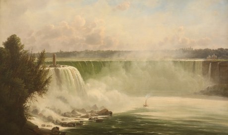
“Niagara Falls Terrapin Point” by Ferdinand Reichardt, 1856.
~ Buffalo History Museum
I crossed the river just below the falls, to the Canada side, and visited the battle-ground of Lundy’s Lane. A village has since sprung up at this place, called Drummondsville, named in honor of the British general who commanded the English troops on that occasion. Most of the battle-ground is now covered by orchards and fields.
I went with Anderson, the guide, (who says he was in the battle as a British soldier,) into an old grave-yard situated near where the British artillery stood, which Col. Miller took at the point of the bayonet. In this grave-yard, Anderson pointed out two graves which he says contains the remains of eighteen American officers. Why cannot American patriotism place some memorial over the graves of these brave men? The only memorial I saw of this kind, on our side, was a painted wooden board, with a simple epitaph, inscribing the name of Captain Hull, of the United States army, stating he had bravely fallen in this battle. Another board of a similar description, erected by the bounty of a corporal and a few privates, over the remains of an English officer, with a tomb-stone placed over Col. Cecil Bishop, of the English forces, who died of wounds received at Black Rock, are all the memorials seen at this burial-ground of Lundy’s Lane, who fell in that action.
~ Niagara Historical Society No. 22 Some Graves on Lundy’s Lane By Ernest Green, page 13.
Col. Gordon, buried in the same ground, lies without a stone. He belonged to the Royal Scotch Highlanders. This battle cost the contending parties over 800 aside, in killed and wounded.
Having seen all worthy of note about the falls, I returned to Buffalo, and sailed at 7 p.m. the same day, on board the St. Louis, for Detroit.
We had on board a large number of emigrants and cabin passengers. The tide of emigration setting west by the lake route is prodigious. Wisconsin, Illinois, Iowa, and Indiana, seem to be the great points of attraction just now.
Having touched at Fair Port and Cleveland, we reached this place on the 22d, early in the morning; having passed Fort Malden some twenty miles below.
Detroit is a handsome and well-laid-off town, and growing continually in population and commercial importance. It is situated on the west bank of the Detroit river, which never overflows or has any material rise or fall. Its water, as well as that of the lakes, affords the most delicious drinking water.
This town is connected in its history with many important scenes. Being early settled by the French, it became involved in the English and French Canadian war; and even before it became a part of the United States, it had changed its flag five times. it was once captured by the Indians, and was burnt down in 1803. In 1805, by the ignominious and disgraceful surrender of Gen. Hull, it fell into the hands of the English. This even took place in the southern part of this town, the spot still being pointed out by old settlers who witnessed the transaction. In 1813, Detroit was retaken by the Americans, when a government was reorganized, and Gen. Lewis Cass appointed its governor.
About fifty miles below this, the river Raisin empties into the lake, at a point called Monroe. It was on this river the bloody massacre of the brave Kentuckians by Indians was perpetrated by the non-interference of the English, under whose protection they had placed themselves as prisoners of war.
At Monroe, a most fiendish and cold-blooded crime was recently committed. it seems, a Mr. Hall, cashier of a bank at Monroe, was decoyed into the woods at night, by a man by the name of Wells, of this place, who was extremely intimate with Hall; when he shot him – once in the back of the head, and once in the back of his body. The deed, it is believed, was committed with the diabolical design of obtaining the keys of the bank from Hall, and robbing it. Young Hall has both balls in him, but still survives; and, strange to say, walked out a day or two since. Wells is in prison, and, like other persons guilty of such horrid crimes, professes “insanity.”

“Hydrographical basin of the upper Mississippi River from astronomical and barometrical observations, surveys, and information,” by Joseph Nicolas Nicollet, et al; published by order of the United States Senate, 1843.
Having a copy of M. Nicollet’s map of the upper basin of the Mississippi with me, I have been led to trace our boundary between this country and England, west from the northwestern shore of Lake Superior, beginning at the mouth of Pigeon river, by the late treaty of Washington; and find we have been most severely cheated in the new line, running from the point indicated to the Lake of the Woods. Soon after parting from Lake Superior, ascending Pigeon river, we come to Hunter’s island, about the size of a large county in one of the States. At the northwest point of this island, Pigeon river divides into two streams – one making an extensive turn to the north, while the other makes a bend to the south, uniting again at the foot of the island. Now, by the old line of boundary, the navigation of the entire river belonged to us, with Hunter’s and other islands. These, with the channel north of the island, which is the deepest, have, by the treaty of Washington, by some unaccountable means, been transferred to the English! Formerly, they yielded up the Pigeon river to our traders, &c., and moved their fort from the mouth of the river some forty miles up the lake, to Thunder Bay, where they built Fort William. They have now again come down (as they have a right to do) to Pigeon river, and interrupt the transit of our traders and people up and down its navigable channels and principal portages. Besides Hunter’s island, we have yielded Isle La Croix, still higher up the river. Hunter’s island is about forty miles long by thirty miles wide, with the deep channel on its northern side. Isle La Croix is about ten miles by fifteen miles in diameter. The line from La Croix west, is made to follow the southern chain of lakes, on the most southern part of Pigeon river, till it reaches the river above them. It then passes to the Lake of the Woods, and from thence to the 49th degree of north latitude, and so on west. What pretext there was for changing our boundary northwest of Lake Superior up Pigeon river, where there never was a boundary in dispute, and where the Pigeon river and Hunter’s island had for years been laid down in British maps as our property, is more than I can tell. Those who negotiated the treaty on our side, must have been grossly ignorant of geography, or they must have been woefully overreached by the British minister.

Thomas Douglas, 5th Earl of Selkirk, was a Scottish peer from the Royal Society of London, and established the Red River Colony along Hudson Bay (1811). This is neither the same person nor place as Alexander Selkirk’s colony on Más-a-Tierra Island, Chile, which inspired Daniel Defoe’s novel, Robinson Crusoe (1719).
The boundary line, stretching across from Lake Superior, along the Pigeon river, to the Lake of the Woods, Red river, &c., is the weakest and most exposed section of the United States. On the Red river of the North, and north of the Pigeon river, is a large body of hardy half-breed Indians, mixed with the Scotch and Germans, who have descended from Alexander Selkirk’s colony, founded near Hudson’s Bay. These people have about six thousand men capable of performing military duty. They come down to the head-waters of the St. Peter’s and Mississippi rivers every season, for the purpose of hunting buffalo, accompanied with their wagons and teams, which, when they have loaded with buffalo meat, they return to their own country. it is said, these men, with the warriors of the Indian tribes stretching west and north of the United States boundary line, number some twenty thousand fighting men, all of whom are under the control of the Hudson Bay (English) Company. In time of war these forces might be organized and brought to bear with destructive effect upon our new upper settlements in Wisconsin and Iowa, and other portions of our northwestern territory. To guard this weak point on our northwestern frontier, our forts are wrongly placed. The forts Snelling, Winnebago, and Wilkins, are too far in the interior.
Government ought, as early as practicable, to adopt measures to build a strong fort at the junction of Pigeon river with Lake Superior, and then to erect detached forts along our entire line of frontier, up Pigeon river to the Lake of the Woods, and from thence along to the Red river, west. These forts would serve to protect our northwestern settlements, and to keep the British and half-breed Indians, with Selkirk’s descendants, in check.
Let any man carefully examine a map of the country we have described, and he will see the propriety of our suggestion.
I leave here in a day or two for Mackinaw, from whence I will write again.
I am very respectfully and truly, yours,
MORGAN.
The Daily Union (Washington D.C.)
“Liberty, The Union, And The Constitution.”
July 5, 1845.
[From our regular correspondent.]
ON BOARD THE STEAMBOAT WISCONSIN,
Bound from Detroit to Mackinac,
June 27, 1845.
After spending some three or four days in Detroit, where I met with the friendly hospitality of a number of friends and acquaintances, I prepared to leave for Mackinac, at the head of Lake Huron.

“Bank of Michigan Building, SW corner of Jefferson and Griswold, built 1836”
~ History of Detroit and Michigan, by Silas Farmer, 1890.
While I was in Detroit, the United States circuit court was in session, Judges McLean and Wilkins presiding. This tribunal now occupies a very neat stone building, formerly erected and owned by the Bank of Michigan. This bank, in winding up its affairs, fell into debt some forty thousand dollars on their interest account, which, after meeting other liabilities, they were unable to discharge. The government, therefore, purchased this house from them at $40,000, and converted it to its present use.
A Presbyterian convention was also in session for a part of the time during my visit.
The large steamboats plying between Buffalo and the upper lakes, all touch at Detroit, to the number of two a day. Many of these are large and splendid structures of their kind. At this season of the year, they run very full of passengers, and, when bound west, carry out a great many emigrants, who are hunting homes in Wisconsin, Iowa, and Illinois. The principal tide is drifting towards Wisconsin at the present, generally landing at Milwaukie, and pushing out into the interior. The boats running on the upper lakes, are at present united in a combination to regular prices. From Buffalo to Chicago, they charge as follows: for cabin passage, 12 dollars; for deck passage, 6 dollars. Cabin to Detroit, 6 dollars; deck, 3 dollars. From Detroit to Mackinac: cabin, 7 dollars; for deck, 4 dollars. Meals for deck passengers charged 25 cents each, extra.
We found the Wisconsin pretty well crowded with passengers when we went on board. Among the deck people were several farmers’ families from Sussex, in England, bound out to Wisconsin, intending to land at Milwaukie, and proceed from thence some little distance into the interior.
On the 26th instant, the United States steam-ship Michigan, and the United States garrison near Detroit, fired minute-guns during the day, in obedience to general orders, and in respect to the memory of Gen. Jackson.
The single ten-inch gun fired from the bow of the Michigan made a loud report, which reverberated along the Canadian shore, as well as along the streets of Detroit.
“Map of the Great Western Railway of Canada, and Connections.” Circa 1879.
~ TrainWeb.org
Should the projected railroad to extend from Lake Ontario to Windsor, opposite Detroit, and that now in progress from the latter place to St. Joseph, on Lake Michigan, be completed, it will have a tendency to make this city a great thoroughfare for travellers, &c., going west.
Leaving Detroit about 9 a.m., we continued up the river till we came to Lake St. Clair. In our progress through it, we could see, by the aid of the glass, the bay formed on its eastern or Canadian side by the entrance of the river Thames, some distance up which, the celebrated battle was fought, which resulted in the death of Tecumseh. Gen. Cass, who now resides in Detroit, dispensing kindness and hospitality to his friends, was in that action, with Gen. Harrison.
From Lake St. Clair, we entered St. Clair river, which is a beautiful stream, forming the southern outlet to Lake Huron. It has cut itself a beautiful canal, on a large scale, through a level country, like Detroit river, leaving gravelly banks, of moderate elevation, on either side. The banks of this river, and especially on the American side, are pretty thickly settled. For some distance in the interior, on the Canada side, the Indians still remain in considerable numbers. At one point, we passed a village of theirs, on the river. At various points, we saw considerable parties of them, either engaged in fishing or travelling, or encamped.
In the afternoon we passed a village on the American side, called Palmer, where a Michigan volunteer company were out on parade, whose band of music greeted us with some lively airs. Near the head of the river, we passed a missionary school and station on the English side; and near the foot of Lake Huron, Fort Gratiot.
For a mile after the St. Clair leaves Lake Huron, the current has a force of six or seven miles per hour. Sail-vessels find it very difficult to stem it; and can only do so, when bound up, by the aid of stiff southerly winds. This river and rapids area serious obstacle to the passage of sail-vessels from the lower to the upper lakes. They are said often to remain wind-bound for a week or more in this river, and at the foot of the rapids. By aid of a tow-path along the shore, on the American side, a mile long, the length of the strongest current, I should think vessels might be pulled up by horse-power into the lake at any time.

“A painting by Paul Kane depicts an encampment on the shores of Lake Huron in about 1845.”
~ The Granger Collection, New York
Late in the afternoon of yesterday, we entered Lake Huron, a huge inland sea. On our right was a vast sheet of water, meeting the horizon, shutting out all sight of land in that direction. We still, however, kept in sight of the western, or American shore; although, at the distance at which we sailed from it, we could see only a small settlement now and then.
The wind, with some clouds and rain, sprung up from the NNE., and threatened a stormy night; but, as the sun went down, the wind fell, the clouds dispersed, and we had a clear, cool, and beautiful starlight night. With conversation, and listening to some music on a piano in the saloon, the evening passed off pleasantly.
The sun this morning rose bright and clear, from the pure bosom of the lake, bringing us a fine and pleasant day.
There is no better tasted, or purer drinking-water found in the world, than that found in these lakes – and especially in the upper lakes. They are, in fact, nothing more than pure fresh-water ocean springs. Your coolest wells in Washington, the Croton in New York, or Schuylkill of Philadelphia, bear scarcely any comparison to this lake water. There is one advantage to mariners navigating these inland seas – under no circumstances are they likely to suffer from a scarcity of drinking-water.
About half-past 2 to 3 p.m., we landed at Mackinac; which I found to be one of the most picturesque and beautiful places I have seen since leaving New York.
As I shall have another opportunity of writing to you from this place, I will say no more at present; but remain your very obedient and humble servant,
MORGAN.
To be continued in Mackinac and Sault Ste Marie…
The Story of Chequamegon Bay
March 1, 2016
By Amorin Mello
This is a reproduction of Reuben Gold Thwaites’ 1895 “The Story of Chequamegon Bay” to demonstrate how our local history has been institutionalized and portrayed since the end of the 19th century. Thwaites’ professional legacy as a journalist is embedded in many institutions, including the following:
- American Library Association
- American Antiquarian Society
- University of Wisconsin
- Wisconsin State Journal
- Wisconsin Historical Society
- Mississippi Valley Historical Association
According to Wikipedia:
Thwaites was well-known for not being a mere academic, but rather as a historian who attempted to understand history by experiencing those aspects that he could, and bringing those experiences to life. In 1888 he took canoe trips on the Wisconsin, Fox and Rock rivers. In 1892 he took a bicycle trip across England. In 1903 he took a trip down the Ohio River in a rowboat.
Thwaites’ approach and work has been questioned, to some degree by his contemporaries but more so in modern times. His summaries include phraseology such as “[Europeans] left the most luxurious country in Europe to seek shelter in the foul and unwelcome huts of one of the most wretched races of man.” When editing the Jesuit Relations, he included background information that is generally credible and thorough with respect to events and Europe, but is far less thorough in regard to the disruptions from disease and other sources that the indigenous people themselves were facing. In other words, the criticism is that the original works were insensitive, and Thwaites failed to fully account for the prejudicial and inaccurate reporting in the Relations. However, Thwaites is also recognized as being the pioneer in an approach to using the Relations that is continuing to be enriched by modern scholarship, and so in a sense he started a process by which his very work could be corrected and improved as historians learn more about the periods in question.
The purpose of reproducing this story is to serve as an introduction to Chequamegon Bay history, and as a reference point for modern scholarship and primary research about Chequamegon Bay before 1860.
The Story about Chequamegon Bay was originally published in Collections of the State Historical Society of Wisconsin: Volume XIII, by Reuben Gold Thwaites, 1895, pages 397-425.
The Story Of Chequamegon Bay.
by the Editor.

Reuben Gold Thwaites
~ Wisconsin Historical Society
WE commonly think of Wisconsin as a young State. In a certain sense she is. There are men now living, two or three of whom I meet almost daily, who were blazing paths through the Wisconsin wilderness, only sixty years ago: men who cleared the forests and broke the prairies; who founded frontier communities which have developed into cities; who upon this far away border sowed the seeds of industries which to-day support tens of thousands of their fellows; who threw up their hats when the Territory was erected; and who sat in the convention which gave to the new State a constitution. The Wisconsin of to-day, the Wisconsin which we know, is indeed young; for the lively octogenarians who were in at the birth will not admit that they are now old. But there was an earlier, a less prosaic, a far more romantic Wisconsin,—the French Wisconsin; and it had flourished in its own fashion for full two centuries before the coming of the Anglo-Saxon, who, brusquely crowding the Creole to the wall, made of his old home an American Commonwealth.
In 1634, when the child born upon the Mayflower was but in her fourteenth year, Jean Nicolet, sent out by the enterprising Champlain as far as Wisconsin,— a thousand miles of canoe journey west from Quebec,— made trading contracts, such as they were, with a half-score of squalid tribes huddled in widely-separated villages throughout the broad wilderness lying between Lakes Superior and Michigan. It was a daring, laborious expedition, as notable in its day as Livingstone’s earliest exploits in Darkest Africa ; and although its results were slow of development,—for in the seventeenth century man was still cautiously deliberate,— this initial visit of the forest ambassador of New France to the country of the Upper Lakes broke the path for a train of events which were of mighty significance in American history.1

“Jean Nicolet, landing at the Bay of Green Bay in 1634. Painted by Franz Edward Rohrbeck (1852-1919) in 1910 into the mural in the rotunda of the Brown County Courthouse, Green Bay, Wisconsin. It shows Nicolet wearing a Chinese damask tunic strewn with flowers and birds, and discharging two pistols into the air.”
~ Wikipedia.org
Let us examine the topography of Wisconsin. The State is situated at the head of the chain of Great Lakes. It is touched on the east by Lake Michigan, on the north by Lake Superior, on the west by the Mississippi, and is drained by interlacing rivers which so closely approach each other that the canoe voyager can with case pass from one great water system to the other; he can enter the continent at the Gulf of St. Lawrence, and by means of numerous narrow portages in Wisconsin emerge into the south-flowing Mississippi, eventually returning to the Atlantic through the Gulf of Mexico. From Lake Michigan, the Fox-Wisconsin river system was the most popular highway to the great river; into Lake Superior, there flow numerous turbulent streams from whose sources lead short portage trails over to the headwaters .of feeders of the Mississippi. From the western shore of Lake Superior, Pigeon River invites to exploration of the Winnipeg country, whence the canoeist can by a half-hundred easy routes reach the distant regions of Athabasca and the Polar Sea. In their early voyages to the head of lake navigation, it was in the course of nature that the French should soon discover Wisconsin; and having discovered it, learn that it was the key-point of the Northwest — the gateway to the entire continental interior. Thus, through Wisconsin’s remarkable system of interlacing waterways, to which Nicolet led the way, New France largely prosecuted her far-reaching forest trade and her missionary explorations, securing a nominal control of the basin of the Mississippi at a time when Anglo-Saxons had gained little more of the Atlantic slope than could be seen from the mast-head of a caravel. Thus the geographical character of Wisconsin became, early in the history of New France, an important factor. The trading posts and Jesuit missions on Chequamegon Bay2 of Lake Superior, and on Green Bay of Lake Michigan, soon played a prominent part in American exploration. The career of Green Bay is familiar to us all.3 I have thought it well hastily to summarize, in the brief space allowed me, the equally instructive story of Chequamegon Bay.

“Outline Map showing the position of the ancient mine-pits of Point Keweenaw, Michigan”
~ Ancient Mining on the Shores of Lake Superior, by Charles Whittlesey
The sandstone cliffs of Lake Superior were, many geologists think, among the first Laurentian islands to arise from the ancient ocean; if this be so, then the rim of our greatest inland sea is one of the oldest spots on earth. In its numerous mines of copper, prehistoric man long delved and wrought with rude hammers and chisels of stone, fashioning those curious copper implements which are carefully treasured in American museums of archaeology;4 and upon its rugged shores the Caucasian early planted his stake, when between him and New England tidewater all was savagery.
Pierre d’Esprit Sieur Radisson
~ Dictionary of Canadian Biography
After the coming to Wisconsin of Nicolet, a long period followed, in which the energies of New France were devoted to fighting back the Iroquois, who swarmed before the very gates of Quebec and Montreal. Exploration was for the time impossible. A quarter of a century passes away before we have evidence of another white man upon Wisconsin soil. In the spring of 1659, the Indians of the valley of the Fox were visited by two French fur-traders from the Lower St. Lawrence – Pierre d’Esprit, Sieur Radisson, and his sister’s husband, Medard Chouart, Sieur de Groseilliers. In all American history there are no characters more picturesque than these two adventurous Creoles, who, in their fond desire to “travell and see countries,” and “to be known as the remotest people,” roamed at will over the broad region between St. Jame’s seaway and the Wisconsin River, having many curious experiences with wild beasts and wilder men. They made several important geographical discoveries, – among them, probably, the discovery of the Mississippi River in 1659, fourteen years before the visit of Joliet and Marquette; and from a trading settlement proposed by them to the English, when their fellow-countrymen no longer gave them employment, developed the great establishment of the Hudson’s Bay Company. The unconsciously-amusing narrative which Radisson afterwards wrote, for the editication of King Charles II, of England, is one of the most interesting known to American antiquaries.5

“Arrival of Radisson in an Indian camp, 1660”
by Charles William Jefferys
~ Wikimedia.org
Two years after Radisson and Groseilliers were upon the Fox River, and made their notable trip to the Mississippi, they were again in the Northwest (autumn of 1661), and this time upon Lake Superior, which they had approached by carrying around the Sault Ste. Marie. Skirting the southern shore of the lake, past the now famous Pictured Rocks, they carried across Keweenaw Point, visited a band of Christino Indians6 not far from the mouth of Montreal River, now the far western boundary between Upper Michigan and Wisconsin, and, portaging across the base of the Chequamegon Island of to-day, – then united to the mainland,- entered beautiful Chequamegon Bay. Just where they made their camp, it is impossible from Radisson’s confused narrative to say; but that it was upon the mainland no Wisconsin antiquary now doubts, and we have reason to believe that it was upon the southwest shore, between the modern towns of Ashland and Washburn.7

“Close-up of the Radisson and Groseilliers house historic site marker, commemorating the first house built in Wisconsin by white men. The house was believed to have stood in the vicinity of Ashland at the mouth of Fish Creek where it empties into Chequamegon Bay.”
~ Wisconsin Historical Society
Our chronicler writes, with a particularity of detail suggestive of De Foe:
“We went about to make a fort of stakes, w’ was in this manner. Suppose that the watter-side had ben in one end; att the same end there should be murtherers, and att need we made a bastion in a triangle to defend us from assault. The doore was neare the watter side, our fire was in the midle, and our bed on the right hand, covered. There were boughs of trees all about our fort layed acrosse, one uppon an other. Besides those boughs, we had a long cord tyed w’ some small bells, w’ weare sentereys. Finally, we made an ende of that fort in 2 dayes’ time.”
“Front view of the Radisson cabin, the first house built by a white man in Wisconsin. It was built between 1650 and 1660 on Chequamegon Bay, in the vicinity of Ashland. This drawing is not necessarily historically accurate.”
~ Wisconsin Historical Society
Modernize this statement, and in imagination we can see this first dwelling erected by man on the shores of Lake Superior; a small log hut, built possibly on the extremity of a small rocky promontory; the door opens to the water front, while the land side, to the rear of the hut, is defended by a salient of palisades stretching from bank to bank of the narrow promontory; all about the rude structure is a wall of pine boughs piled one upon the other, with a long cord intertwined, and on this cord are strung numbers of the little hawk-bells then largely used in the Indian trade for purposes of gift and barter. It was expected that in case of a night attack from savages, who might be willing to kill them for the sake of their stores, the enemy would stir the boughs and unwittingly ring the bells, thus arousing the little garrison. These ingenious defenses were not put to the test, although no doubt they had a good moral effect; in keeping the thieving Hurons at a respectful distance.
Winter was just setting in. The waters of the noble bay were taking on that black and sullen aspect peculiar to the season. The beautiful islands, later named for the Twelve Apostles,8 looked gloomy indeed in their dark evergreen mantles. From the precipitous edges of the red-sandstone cliffs, which girt about this estuary of our greatest inland sea, the dense pine forests stretched westward and southward for hundreds of miles. Here and there in the primeval depths was a cluster of starveling Algonkins, still trembling from fear of a return of the Iroquois, who had chased them from Canada into this land of swamps and tangled woods, where their safety lay in hiding. At wide intervals, uncertain trails led from village to village, and in places the rivers were convenient highways; these narrow paths, however, beset with danger in a thousand shapes, but emphasized the unspeakable terrors of the wilderness.
Père René Ménard
“The Search for Wisconsin’s First Priest”
~ Wisconsin Historical Society
Radisson and Groseilliers, true coureurs de bois, were not daunted by the dangers which daily beset them. After caching their goods, they passed the winter of 1661-62 with their Huron neighbors, upon a prolonged hunt, far into the Mille Lacs region of Minnesota. The season was phenomenally severe, and the Indians could not find game enough to sustain life. A famine ensued in the camp, the tragical details of which are painted by our friend Radisson with Hogarthian minuteness. In the spring of 1662, the traders were back again at Chequamegon, and built another fortified shelter, this time possibly on the sand-spit of Shagawaumikong,9 from which base they once more wandered in search of adventures and peltries, going as far northwest as Lake Assiniboine, and later in the season returning to their home on the Lower St. Lawrence.
When Radisson’s party went to Lake Superior, in the autumn of 1661, they were accompanied as far as Keweenaw Bay by a Jesuit priest. Father Pierre Ménard, who established there a mission among the Ottawas. The following June, disheartened in his attempt to convert these obdurate tribesmen, Ménard set out for the Huron villages on the upper waters of the Black and Chippewa, but perished on the way.10
It was not until August of 1665, three years later, that Father Claude Allouez, another Jesuit, was sent to reopen the abandoned Ottawa mission on Lake Superior. He chose his site on the southwestern shore of Chequamegon Bay, possibly the same spot on which Radisson’s hut had been built, four years previous, and piously called his mission and the locality La Pointe du Saint Esprit, which in time was shortened to La Pointe.11

Detail of La Pointe du Saint Esprit
from Claude Allouez map’s of New France, 1669.
~ Research Laboratories of Archaeology

Portrayal of Claude Allouez
~ National Park Service
At the time of Radisson’s visit, the shores of Chequamegon Bay were uninhabited save by a few half-starved Hurons ; but soon thereafter it became the centre of a considerable Indian population, residents of several tribes having been drawn thither, first, by the fisheries, second, by a fancied security in so isolated a region against the Iroquois of the East and the wild Sioux of the West. When Allouez arrived in this polyglot village, October 1, he found there Chippewas, Pottawattómies, Kickapoos, Sauks, and Foxes, all of them Wisconsin tribes; besides these were Hurons, Ottawas, Miamis, and Illinois,— victims of Iroquois hate who had fled in droves before the westward advances of their merciless tormentors.

Jacques Marquette
aka James (Jim) or Père Marquette
~ Wikipedia
Despite his large congregations, Allouez made little headway among these people, being consoled for his hardships and ill-treatment by the devotion of a mere handful of followers. For four years did he labor alone in the Wisconsin wilderness, hoping against hope, varying the monotony of his dreary task by occasional canoe voyages to Quebec, to report progress to his father superior. Father James Marquette, a more youthful zealot, was at last sent to relieve him, and in September, 1669, arrived at La Pointe from Sault Ste. Marie, after spending a full month upon, the journey,—so hampered was he, at that early season, by snow and ice. Allouez, thus relieved from a work that had doubtless palled upon him, proceeded upon invitation of the Pottawattomies to Green Bay, where he arrived early in December, and founded the second Jesuit mission in Wisconsin, St. Francis Xavier, on the site of the modern town of Depere.12
Marquette had succeeded to an uncomfortable berth. Despite his strenuous efforts as a peacemaker, his dusky parishioners soon unwisely quarreled with their western neighbors, the Sioux,13 with the result that the La Pointe bands, and Marquette with them, were driven like leaves before an autumn blast eastward along the southern shore of the great lake: the Ottawas taking up their home in the Manitoulin Islands of Lake Huron, the Hurons accompanying Marquette to the Straits of Mackinaw, where he established the mission of St. Ignace.
With La Pointe mission abandoned, and Lake Superior closed to French enterprise by the “raging Sioux,” the mission at Depere now became the centre of Jesuit operations in Wisconsin, and it was a hundred and sixty-four years later (1835), before mass was again said upon the forest-fringed shores of Chequamegon Bay.
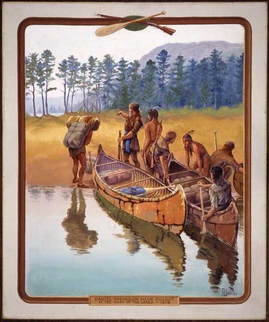
“‘Daniel Greysolon Sieur Dulhut at the Head of the Lakes – 1679.’ Painted by artist Francis Lee Jaques, c.1922.”
~ Minnesota Historical Society
Although the missionary had deserted La Pointe, the fur trader soon came to be much in evidence there. The spirit of Radisson and Groseilliers long permeated this out-of-the-way corner of the Northwest. We find (1673), three years after Marquette’s expulsion. La Salle’s trading agent, Sieur Raudin, cajoling the now relentent Sioux at the western end of Lake Superior. In the summer of 1679, that dashing coureur de bois, Daniel Grayson du l’ Hut,14 ascended the St. Louis River, which divides Wisconsin and Minnesota, and penetrated with his lively crew of voyageurs to the Sandy Lake country, being probably the first white trader upon the head-waters of the Mississippi. The succeeding winter, he spent in profitable commerce with the Assiniboines, Crees, and other northern tribes in the neighborhood of Grand Portage,15 on the boundary between Minnesota and Canada. In June, 1680, probably unaware of the easier portage by way of the Mille Lacs and Rum River, Du I’ Hut set out at the head of a small company of employees to reach the Mississippi by a new route. Entering the narrow and turbulent Bois Brulé,16 half-way along the southern shore of Lake Superior, between Red Cliff and St. Louis River, he with difficulty made his way over the fallen trees and beaver dams which then choked its course. From its head waters there is a mile-long portage to the upper St. Croix; this traversed. Du l’ Hut was upon a romantic stream which swiftly carried him, through foaming rapids and deep, cool lakes, down into the Father of Waters. Here it was that he heard of Father Louis Hennepin’s captivity among the Sioux, and with much address and some courage rescued that doughty adventurer, and carried him by way of the Fox-Wisconsin route in safety to Mackinaw.
…
“In 1693, Le Sueur founded a trading post on the site of present-day La Pointe on Madeline Island, the largest of Chequamegon Bay’s Apostle Islands. After hearing reports of what he believed were valuable deposits of copper ore south of Lake Superior, he traveled to France in 1697, where the French government granted him permission to mine these resources.”
~ Encyclopedia of Exploration, vol. 1, 2004.
An adventurous forest trader, named Le Sueur, was the next man to imprint his name on the page of Lake Superior history. The Fox Indians, who controlled the valleys of the Fox and Wisconsin Rivers, had for various reasons become so hostile to the French that those divergent streams were no longer safe as a gateway from the Great Lakes to the Great River. The tendency of the prolonged Fox War was to force fur trade travel to the portages of Chicago and St. Joseph’s on the south, and those of Lake Superior on the north.17 It was with a view to keeping open one of Du l’ Hut’s old routes, – the Bois Brulé and St. Croix Rivers,- that Le Sueur was despatched by the authorities of New France in 1693. He built a stockaded fort on Madelaine island, convenient for guarding the northern approach,18 and another on an island in the Mississippi, below the mouth of the St. Croix, and near the present town of Red Wing, Minnesota. The post in the Mississippi soon became “the centre of commerce for the Western parts”; and the station in Chequamegon Bay also soon rose to importance, for the Chippewas, who had drifted far inland into Wisconsin and Minnesota with the growing scarcity of game,- the natural result of the indiscriminate slaughter which the fur trade encouraged, – were induced by the new trading facilities to return to their old bay shore haunts, massing themselves in an important village on the southwestern shore.
This incident strikingly illustrates the important part which the trader early came to play in Indian life. At first an agriculturalist in a small way, and a hunter and fisher only so far as the daily necessities of food and clothing required, the Indian was induced by the white man to kill animals for their furs, – luxuries ever in great demand in the marts of civilization. The savage wholly devoted himself to the chase, and it became necessary for the white man to supply him with clothing, tools, weapons, and ornaments of European manufacture; the currency as well as the necessities of the wilderness.19 These articles the savage had heretofore laboriously fashioned for himself at great expenditure of time; no longer was he content with native manufactures, and indeed he quickly lost his old-time facility for making them. It was not long before he was almost wholly dependent on the white trader for the commonest conveniences of life; no longer being tied to his fields, he became more and more a nomad, roving restlessly to and fro in search of fur-bearing game, and quickly populating or depopulating a district according to the conditions of trade. Without his trader, he quickly sank into misery and despair; with the advent of the trader, a certain sort of prosperity once more reigned in the tepee of the red man. In the story of Chequamegon Bay, the heroes are the fur trader and the missionary; and of these the fur trader is the greater, for without his presence on this scene there would have been no Indians to convert.
~ State of Wisconsin Blue Book, 1925, page 66.
Although Le Sueur was not many years in command upon Chequamegon Bay,20 we catch frequent glimpses thereafter of stockaded fur trade stations here, – French, English, and American, in turn, – the most of them doubtless being on Madelaine Island, which was easily defensible from the mainland.21 We know that in 1717 there was a French trader at La Pointe – the popular name for the entire bay district—for he was asked by Lt. Robertel de la Noüe, who was then at Kaministiquoya, to forward a letter to a certain Sioux chief. In September, 1718, Captain Paul Legardeur St. Pierre, whose mother was a daughter of Jean Nicolet, Wisconsin’s first explorer, was sent to command at Chequamegon, assisted by Ensign Linctot, the authorities of the lower country having been informed that the Chippewa chief there was, with his fellow-chief at Keweenaw, going to war with the Foxes. St. Pierre was at Chequamegon for at least a year, and was succeeded by Linctot, who effected an important peace between the Chippewas and Sioux.22
The Indians at La Pointe told the French of an island of copper guarded by spirits; La Ronde, when he heard of the mineral, requested permission from the French Government to combine his duties at the fort with mining. he was not given permission to operate the mines until 1733, and in 1740 his mining activities were halted by an outbreak between the Sioux and the Chippewa. Nonetheless, La Ronde is known as the first practical miner on Lake Superior, and the man who opened this region for settlement by white men.”
~ The WPA Guide to Wisconsin, by Federal Writers’ Project, 2013, page 348.
~ Dictionary of Canadian Biography
Whether a garrisoned fort was maintained at Chequamegon Bay, from St. Pierre’s time to the close of the French domination, it is impossible to say; but it seems probable; for the geographical position was one of great importance in the development of the fur trade, and the few records we have mention the fort as one of long standing.23 In 1730, it is recorded, that a nugget of copper was brought to the post by an Indian, and search was at once made for a mine; but October 18, 1731, the authorities of New France wrote to the home office in Paris that, owing to the superstitions of the Indians, which led them to conceal mineral wealth from the whites, no copper mine had thus far been found in the neighborhood of Chequamegon Bay. The commandant of Chequamegon at this time was Sieur La Ronde Denis, known to history as La Ronde,— like his predecessors, for the most part, a considerable trader in these far Western parts, and necessarily a man of enterprise and vigor. La Ronde was for many years the chief trader in the Lake Superior country, his son and partner being Denis de La Ronde. They built for their trade a boat of 40 tons, which was without doubt “the first vessel on the great lake, with sails larger than an Indian blanket.” 24 On account of the great outlay they had incurred in this and other undertakings in the wilderness, the post of Chequamegon, with its trading monopoly, had been given to the elder La Ronde, according to a despatch of that day, “as a gratuity to defray expenses.” Other allusions to the La Rondes are not infrequent: in 1736,25 the son is ordered to investigate a report of a copper mine at Iron River, not far east of the Bois Brulé; in the spring of 1740, the father is at Mackinaw on his return to Chequamegon from a visit to the lower country, but being sick is obliged to return to Montreal;26 and in 1744, Bellin’s map gives the name “Isle de la Ronde” to what we now know as Madelaine, fair evidence that the French post of this period was on that island.

Detail of Isle de la Ronde from Carte des lacs du Canada by Jacques-Nicolas Bellin, 1744.
~ Wisconsin Historical Society
Pierre-Joseph was the son of Joseph Hertel de St.Francois & Catherine Philippe, born in Trois-Rivieres. He married Catherine-Madeleine Jarrot (daughter of Jean Bte.Jarrot, sieur de Vercheres & Madeleine Francoise d’Ailleboust de Manthet) in 1751. [Her father commanded the post at Green Bay in 1747].
Pierre-Joseph followed in his families tradition and was a captain on a raid of Albany in 1756 during the King George’s War. From 1756 to 1758 he was commander of the post of Lapointe (in today’s northern Wisconsin) and sailed for France after the loss of Canada to the British.”
~ [Unknown].
We hear nothing more of importance concerning Chequamegon until about 1756, when Hertel de Beaubassin, the last French commandant there, was summoned to Lower Canada with his Chippewa allies, to do battle against the English.27 For several years past, wandering English fur traders had been tampering with the Chippewas of Lake Superior, who in consequence frequently maltreated their old friends, the French;28 but now that the tribe were summoned for actual fighting in the lower country, with extravagant promises of presents, booty, and scalps, they with other Wisconsin Indians eagerly flocked under the French banner, and in painted swarms appeared on the banks of the St. Lawrence, with no better result than to embarrass the French commissariat and thus unwittingly aid the ambitious English.
New France was tottering to her fall. The little garrison on Madelaine Island had been withdrawn from the frontier, with many another like it, to help in the defense of the lower country ; and the Upper Lakes, no longer policed by the fur trade monopoly, were free plunder for unlicensed traders, or coureurs des bois. Doubtless such were the party who encamped upon the island during the autumn of 1760. By the time winter had set in upon them, all had left for their wintering grounds in the forests of the far West and Northwest, save a clerk named Joseph, who remained in charge of the stores and the local traffic. With him were his little family,—his wife, who was from Montreal, his child, a small boy, and a man-servant, or voyageur. Traditions differ as to the cause of the servant’s action,— some have it, a desire for wholesale plunder; others, the being detected in a series of petty thefts, which Joseph threatened to report; others, an unholy and unrequited passion for Joseph’s wife. However that may be, the servant murdered first the clerk, and then the wife; and in a few days, stung by the piteous cries of the child, the lad himself. When the spring came, and the traders returned to Chequamegon, they inquired for Joseph and his family, but the servant’s reply was unsatisfactory and he finally confessed to his horrid deed. The story goes, that in horror the traders dismantled the old French fort as a thing accursed, sunk the cannon in a neighboring pool, and so destroyed the palisade that to-day naught remains save grassy mounds. Carrying their prisoner with them on their return voyage to Montreal, he is said to have escaped to the Hurons, among whom he boasted of his deed, only to be killed as too cruel a companion even for savages.29

Detail of “The 12 Apostles” from Captain Jonathan Carver’s journal of his travels with maps and drawings, 1769. ~ Boston Public Library
Alexander Henry , The Elder.
~ Wikipedia.com
New France having now fallen, an English trader, Alexander Henry, spent the winter of 1765-66 upon the mainland, opposite the island.30 Henry had obtained from the English commandant at Mackinaw the exclusive trade of Lake Superior, and at Sault Ste. Marie took into partnership with him Jean Baptiste Cadotte,31 a thrifty Frenchman, who for many years thereafter was one of the most prominent characters on the Upper Lakes. Henry and Cadotte spent several winters together on Lake Superior, but only one upon the shores of Chequamegon, which Henry styles “the metropolis of the Chippeways.”32

John Johnston
~ Homestead.org
The next dweller at Chequamegon Bay, of whom, we have record, was John Johnston, a Scotch-Irish fur trader of some education. Johnston established himself on Madelaine Island, not far from the site of the old French fort; some four miles across the water, on the mainland to the west, near where is now the white town of Bayfield, was a Chippewa village with whose inhabitants he engaged in traffic. Waubojeeg (White Fisher), a forest celebrity in his day, was the village chief at this time, and possessed of a comely daughter whom Johnston soon sought and obtained in marriage. Taking his bride to his island home, Johnston appears to have lived there for a year or two in friendly commerce with the natives, at last retiring to his old station at Sault Ste. Marie.33
Mention has been made of Jean Baptiste Cadotte, who was a partner of Alexander Henry in the latter’s Lake Superior trade, soon after the middle of the century. Cadotte, whose wife was a Chippewa, after his venture with Henry had returned to Sault Ste. Marie, from which point he conducted an extensive trade through the Northwest. Burdened with advancing years, he retired from the traffic in 1796, and divided the business between his two sons, Jean Baptiste and Michel.

Michel Cadotte
~ Findagrave.com
About the opening of the present century,34 Michel took up his abode on Madelaine Island, and from that time to the present there has been a continuous settlement upon it. He had been educated at Montreal, and marrying Equaysayway, the daughter of White Crane, the village chief of La Pointe,35 at once became a person of much importance in the Lake Superior country. Upon the old trading site at the southwestern corner of the island, by this time commonly called La Pointe,— borrowing the name, as we have seen, from the original La Pointe, on the mainland, and it in turn from Point Chequamegon,—Cadotte for over a quarter of a century lived at his ease; here he cultivated a “comfortable little farm,” commanded a fluctuating, but often far-reaching fur trade, first as agent of the Northwest Company and later of Astor’s American Fur Company, and reared a considerable family, the sons of which were, as he had been, educated at Montreal, and became the heads of families of Creole traders, interpreters, and voyageurs whom antiquarians now eagerly seek when engaged in bringing to light the French and Indian traditions of Lake Superior.36
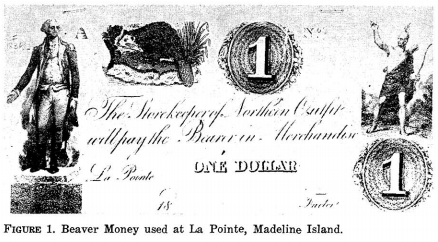
La Pointe Beaver Money
Northern Outfit, American Fur Company
~ Wisconsin Academy of Science, Arts, & Letters, volume 54, page 159.
In the year 1818 there came to the Lake Superior country two sturdy, fairly-educated37 young men, natives of the Berkshire hills of Massachusetts,—Lyman Marcus Warren, and his younger brother, Truman Abraham. They were of the purest New England stock, being lineally descended from Richard Warren, one of the “Mayflower” company. Engaging in the fur trade, the brothers soon became popular with the Chippewas, and in 1821 still further entrenched themselves in the affections of the tribesmen by marrying the two half-breed daughters of old Michel Cadotte,—Lyman taking unto himself Mary, while Charlotte became the wife of Truman. At first the Warrens worked in opposition to the American Fur Company, but John Jacob Astor’s lieutenants were shrewd men and understood the art of overcoming commercial rivals. Lyman was made by them a partner in the lake traffic, and in 1824 established himself at-La Pointe as the company’s agent for the Lac Flambeau, Lac Courte Oreille, and St. Croix departments, an arrangement which continued for some fourteen years. The year previous, the brothers had bought out the interests of their father-in-law, who now, much reduced in means, retired to private life after forty years’ prosecution of the forest trade.38

American Fur Company “Map of La Pointe”
by Lyman Marcus Warren, 1834.
~ Wisconsin Historical Society
The brothers Warren were the last of the great La Pointe fur traders.39 Truman passed away early in his career, having expired in 1825, while upon a voyage between Mackinaw and Detroit. Lyman lived at La Pointe until 1838, when his connection with the American Fur Company was dissolved, and then became United States sub-agent to the Chippewa reservation on Chippewa River, where he died on the tenth of October, 1847, aged fifty-three years.40

Iu Otoshki-Kikindiuin Au Tebeniminvng Gaie Bemajiinung Jesus Christ, Ima Ojibue Inueuining Giizhitong:
The New Testament of Our Lord and Saviour Jesus Christ
by Sherman Hall and Henry Blatchford, 1856.
~ Archive.org
Lyman Marcus Warren was a Presbyterian, and, although possessed of a Catholic wife, was the first to invite Protestant missionaries to Lake. Superior. Not since the days of Allouez had there been an ordained minister at La Pointe; Warren was solicitous for the spiritual welfare of his Chippewa friends, especially the young, who were being reared without religious instruction, and subject to the demoralizing influence of a rough element of white borderers. The Catholic Church was not just then ready to reenter the long-neglected field; his predilections, too, were for the Protestant faith. In 1830, while upon his annual summer trip to Mackinaw for supplies, be secured the cooperation of Frederick Ayer, of the Mackinaw mission, who returned with him in his batteau as lay preacher and school-teacher, and opened at La Pointe what was then the only mission upon the shores of the great lake. Thither came in Warren’s company, the latter part of August, the following year (1831), Rev. Sherman Hall and wife, who served as missionary and teacher, respectively, and Mrs. John Campbell, an interpreter.41
La Pointe was then upon the site of the old French trading post at the southwest corner of Madelaine Island; and there, on the first Sunday afternoon after his arrival, Mr. Hall preached “the first sermon ever delivered in this place by a regularly-ordained Christian minister.” The missionaries appear to have been kindly received by the Catholic Creoles, several of whom were now domiciled at La Pointe. The school was patronized by most of the families upon the island, red and white, who had children of proper age. By the first of September there was an average attendance of twenty-five. Instruction was given almost wholly in the English language, with regular Sunday-school exercises for the children, and frequent gospel meetings for the Indian and Creole adults.
We have seen that the first La Pointe village was at the southwestern extremity of the island. This was known as the “Old Fort” site, for here had been the original Chippewa village, and later the fur-trading posts of the French and English. Gradually, the old harbor became shallow, because of the shifting sand, and unfit for the new and larger vessels which came to be used in the fur trade.

The American Fur Company therefore built a “New Fort” a few miles farther north, still upon the west shore of the island, and to this place, the present village, the name La Pointe came to be transferred. Half-way between the “Old fort” and the “New fort,” Mr. Hall erected (probably in 1832) “a place for worship and teaching,” which came to be the centre of Protestant missionary work in Chequamegon Bay.

Leonard Hemenway Wheeler
~ Unnamed Wisconsin by John Nelson Davidson, 1895.
At that time, the Presbyterians and Congregationalists were, in the American Home Missionary Society and the American Board, united in the conduct of Wisconsin missions, and it is difficult for a layman to understand to which denomination the institution of the original Protestant mission at La Pointe may properly be ascribed. Warren was, according to Neill, a Presbyterian, so also, nominally, were Ayer and Hall, although the last two were latterly rated as Congregationalists. Davidson, a Congregational authority, says: “The first organization of a Congregational church within the present limits of Wisconsin took place at La Pointe in August, 1833, in connection with this mission”;42 and certainly the missionaries who later came to assist Hall were of the Congregational faith; these were Rev. Leonard Hemenway Wheeler and wife, Rev. Woodbridge L. James and wife, and Miss Abigail Spooner. Their work appears to have been as successful as such proselyting endeavors among our American Indians can hope to be, and no doubt did much among the Wisconsin Chippewas to stem the tide of demoralization which upon the free advent of the whites overwhelmed so many of our Western tribes.
James’ family did not long remain at La Pointe. Wheeler was soon recognized as the leading spirit there, although Hail did useful service in the field of publication, his translation of the New Testament into Chippewa (completed in 1836) being among the earliest of Western books. Ayer eventually went to Minnesota. In May, 1845, owing to the removal of the majority of the La Pointe Indians to the new Odanah mission, on Bad River, Wheeler removed thither, and remained their civil, as well as spiritual, counselor until October, 1866, when he retired from the service, full of years and conscious of a record of noble deeds for the uplifting of the savage. Hall tarried at La Pointe until 1853, when he was assigned to Crow Wing reservation, on the Mississippi, thus ending the Protestant mission on Chequamegon Bay. The new church building, begun in 1887, near the present La Pointe landing, had fallen into sad decay, when, in July, 1892, it became the property of the Lake Superior Congregational Club, who purpose to preserve it as an historic treasure, being the first church-home of their denomination in Wisconsin.

Not far from this interesting relic of Protestant pioneering at venerable La Pointe, is a rude structure dedicated to an older faith. Widely has it been advertised, by poets, romancers, and tourist agencies, as “the identical log structure built by Père Marquette”; while within there hangs a picture which we are soberly told by the cicerone was “given by the Pope of that time to Marquette, for his mission church in the wilderness.” It is strange how this fancy was born; stranger still that it persists in living, when so frequently proved unworthy of credence. It is as well known as any fact in modern Wisconsin history,— based on the testimony of living eyewitnesses, as well as on indisputable records,—that upon July 27, 1835, five years after Cadotte had introduced Ayer to Madelaine Island, there arrived at the hybrid village of La Pointe, with but three dollars in his pocket, a worthy Austrian priest. Father (afterwards Bishop) Frederic Baraga. By the side of the Indian graveyard at Middleport, he at once erected “a log chapel, 50×20 ft. and 18 ft. high,” and therein he said mass on the ninth of August, one hundred and sixty-four years after Marquette had been driven from Chequamegon Bay by the onslaught of the Western Sioux.43 Father Baraga’s resuscitated mission, still bearing the name La Pointe, as had the mainland missions of Allouez and Marquette,—throve apace. His “childlike simplicity,” kindly heart, and self-sacrificing labors in their behalf, won to him the Creoles and the now sadly-impoverished tribesmen; and when, in the winter of 1836-37, he was in Europe begging funds for the cause, his simpIe-hearted enthusiasm met with generous response from the faithful.

“Bishop Frederic Baraga, three-quarter length portrait, facing three-quarters to right, seated, in clerical robes, holding his Dictionary of the Otchipwe Language”
~ Library of Congress
Returning to La Pointe in 1837, he finished his little chapel, built log-houses for his half-starved parishioners, and lavished attentions upon them; says Father Verwyst, himself an experienced missionary among the Chippewas : “In fact, he gave them too much altogether—so to say— spoiled them by excessive kindness.” Four years later, his chapel being ill-built and now too small, he had a new one constructed at the modern village of La Pointe, some of the materials of the first being used in the second. This is the building, blessed by Father Baraga on the second Sunday of August, 1841, which is to-day falsely shown to visitors as that of Father Marquette. It is needless to say that no part of the ancient mainland chapel of the Jesuits went into its construction; as for the picture, a “Descent from the Cross,” alleged to have once been in Marquette’s chapel, we have the best of testimony that it was imported by Father Baraga himself from Europe in 1841, he having obtained it there the preceding winter, when upon a second tour to Rome, this time to raise funds for the new church.44 This remarkable man though later raised to a missionary bishopric, continued throughout his life to labor for the uplifting of the Indiana of the Lake Superior country with a self-sacrificing zeal which is rare in the annals of any church, and established a lasting reputation as a student of Indian philology. He left La Pointe mission in 1853, to devote himself to the Menomonees, leaving his work among the Chippewas of Chequamegon Bay to be conducted by others. About the year 1877, the white town of Bayfield, upon the mainland opposite, became the residence of the Franciscan friars who were now placed, in charge. Thus, while the Protestant mission, after a relatively brief career of prosperity, has long, since been removed to Odanah, the Catholics to this day retain possession of their ancient field in Chequamegon Bay.

View of La Pointe, circa 1843.
“American Fur Company with both Mission churches. Sketch purportedly by a Native American youth. Probably an overpainted photographic copy enlargement. Paper on a canvas stretcher.”
~ Wisconsin Historical Society
In closing, let us briefly rehearse the changes in the location of La Pointe, and thus clear our minds of some misconceptions into which several historians have fallen.
- As name-giver, we have Point Chequamegon (or. Shagawaumikong). Originally a long sand-spit hemming in Chequamegon Bay on the east, it is now an island. The most conspicuous object in the local topography, it gave name to the district; and here, at the time of the Columbian discovery, was the Chippewa stronghold.
- The mission of La Pointe du St. Esprit, founded by Allouez, was, it seems well established, on the mainland at the southwestern corner of the bay, somewhere between the present towns of Ashland and Washburn, and possibly on the site of Radisson’s fort. The point which suggested to Allouez the name of his mission was, of course, the neighboring Point Chequamegon.
- The entire region of Chequamegon Bay came soon to bear this name of La Pointe, and early within the present century it was popularly attached to, the island which had previously borne many names, and to-day is legally designated Madelaine.
- When Cadotte’s little trading village sprang up, on the southwestern extremity of the island, on the site of the old Chippewa village and the old French forts, this came to be particularly designated as La Pointe.
- When the American Fur Company established a new fort, a few miles north of the old, the name La Pointe was transferred thereto. This northern village was in popular parlance styled “New Fort,” and the now almost-deserted .southern village “Old Fort”; while the small settlement around the Indian graveyard midway, where Father Baraga built his first chapel, was known as “Middleport.”
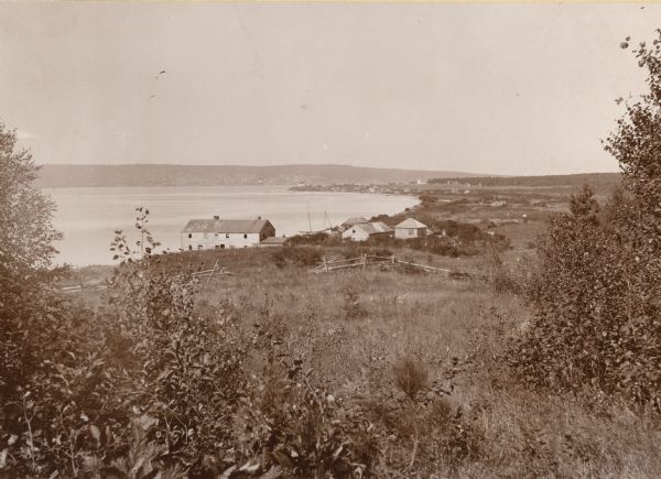
La Pointe, Madelaine Island, Chequamegon Bay, circa 1898.
“The large building in the foreground is an old American Fur Company’s warehouse. The mainland town of Bayfield rests in a hollow of the opposite hills, which appears to merge into the island. This La Pointe, early established as a French military and trading post, must not be confounded with the still earlier missions of La Pointe served by Allouez and Marquette, which is on the mainland on the southwest shore of Chequamegon Bay, between Washburn and Ashland.”
~ Wisconsin Historical Collections, Volume XVI, page 80.
La Pointe has lost much of its old-time significance. No longer is it the refuge of starveling tribes, chased thither by Iroquois, harassed by unneighborly Sioux, and consoled in a measure by the ghostly counsel of Jesuit fathers; no longer a centre of the fur-trade, with coureurs de bois gayly dight, self-seeking English and American factors, Creole traders dispensing largesse to the dusky relatives of their forest brides, and rollicking voyageurs taking no heed of the morrow. Its forest commerce has departed, with the extinction of game and the opening of the Lake Superior country to industrial and agricultural occupation; the Protestant mission has followed the majority of the Indian islanders to mainland reservations; the revived mission of Mother Church has also been quartered upon the bay shore. But the natural charms of Madelaine island, in rocky dell, and matted forest, and sombre, pine-clad shore, are with us still, and over all there floats an aroma of two and a half centuries of historic association, the appreciation of which we need to foster in our materialistic West, for we have none too much of it.
1 The chief authority on Nicolet is Butterfield’s Discovery of the Northwest (Cincinnati, 1881). See also Wis. Hist. Colls., xi, pp. 1-25.
2 In his authoritative “History of the Ojibway Nation,“ in Minn. Hist. Colls., v., Warren prefers the spelling “Chagoumigon,” although recognizing “Shagawaumikong” and “Shaugahwaumikong.” “Chequamegon” is the current modern form. Rev. Edward P. Wheeler, of Ashland, an authority on the Chippewa tongue and traditions, says the pronunciation should be “Sheh-gu-wah-mi-kung,” with the accent on the last syllable.
3 See Nevill and Martin’s Historic Green Bay (Milwaukee,1894); and various articles in the Wisconsin Historical Collections.
4 See Minn. Hist. Colls., v., pp.98, 99, note, for account of early copper mining on Lake Superior by Indians. In the summer of 1892, W. H. Holmes, of the Smithsonian Institution, found on Isle Royale no less than a thousand abandoned shafts which had been worked by them; and “enough stone implements lay around, to stock every museum in the country.”
5 Radisson’s Voyages was published by the Prince Society (Boston, 1895); that portion relation to Wisconsin is reproduced, with notes, in Wis. Hist. Colls., xi. See also Jesuit Relations, 1660, for Father Lallemant’s report of the discoveries of the “two Frenchmen,” who had found “a fine river, great, broad, deep, and comparable, they say, to our great St. Lawrence.”
In Franquelin’s map of 1688, what is now Pigeon River, a part of the international boundary between Minnesota and Canda, is called Groseilliers. An attempt was made by members of the Wisconsin State Historical Society, in the Wisconsin Legislature,during the session of 1895, to have a proposed new county called Radisson; the name was adopted by the friends of the bill, but the measure itself failed to pass.
6 Now called Crees.
7 Radisson’s Voyages plainly indicates that the travelers portaged across the long, narrow sand-spit formerly styled Shagawaumikong, in their day united with the mainland, but now insular, and bearing the name Chequamegon Island; this Radisson describes as “a point of 2 leagues long and some 60 paces broad,”and later he refers to it as “the point that forms that Bay, wch resembles a small lake.” After making this portage of Shagawaumikong, they proceeded in their boats, and “att the end of this bay we landed.” The Ottawas of the party desired to cross over to their villages on the head-waters of the Black and Chippewa, and no landing-place was so advantageous for this purpose as the southwest corner of the bay. It is plain from the narrative that the Frenchmen, now left to themselves, built their fortified hut at or near the place of landing, on the mainland. The Chippewa tradition of the coming of Radisson and Groseilliers, as given by Warren in Minn. Hist. Colls., v., pp. 121, 122, places the camp of the first white men on the eastern extremity of Madeline (or La Pointe) Island. The tradition runs close to the fact in most other particulars; but in the matter of location, Radisson’s journal leaves no room to doubt that the tradition errs.
See post, Father Verwyst’s article, “Historic Sites on Chequamegon Bay,”with notes on the site of Radisson’s fort, by Sam. S. Fifield and Edward P. Wheeler. Verwyst thinks the location to have been “somewhere between Whittlesey’s Creek and Shore’s Landing;” Fifield and Wheeler are confident that it was at Boyd’s Creek.
8 Apparently by Johnathan Carver, in the map accompanying his volume of Travels.
9 Says Warren (Minn. Hist. Colls., v., p. 102): “Shag-a-waum-ik-ong is a narrow neck or point of land about our miles long, and lying nearly parallel to the island of La Pointe, toward the western end of which it converges, till the distance from point to point is not more than two miles.” In first entering the bay, the previous autumn, Radisson describes the point of Shagawaumikong, and says: “That point should be very fitt to build & advantageous for the building of a fort, as we did the spring following.” But later on in his journal, in describing the return to the bay from their winter with the Indians in the Mille Lacs region, he does not mention the exact location of the new “fort.” While in this fort, they “received [news] that the Octanaks [Ottawas] [had] built a fort on the ponit that forms that Bay, wch resembles a small lake. We went towards it with all speede,” – and had a perilous trip thither, across thin ice. This would indicate that the French camp was not on the point. As with many other passages in the journal, it is impossible to reconcile these two statements. Verwyst thinks that the traders were stationed on Houghton Point.
Warren, who had an intimate acquaintance with Chippewa traditions’ believed that that tribe, driven westward by degrees from the shores of the Gulf of St. Lawrence, reached Lake Superior about the time of the Columbian discovery, and came to a stand on Shagaqaumikong Point. “On this spot they remained not long, for they were harassed daily by their warlike foes, and for greater security they were obliged to move their camp to the adjacent island of Mon-in-wun-a-kauning (place of the golden-breasted woodpecker, but known as La Pointe). Here, they chose the site of their ancient town, and it covered a space about three miles long and two broad, comprising the western end of the island.” – (Minn. Hist. Colls., v., p. 96). They remained in this large town “for the space of three generations, or one hundred and twenty years,” but for various reasons (see Ibid, p. 108 et seq., for the details) evacuated the place, and settling on the adjacent mainland came to regard La Pointe Island (now Madeline) as an abode of evil spirits, upon which, it is said, until the days of Cadotte, no Indian dare stay over night alone. Gradually, as the beaver grew more scarce, the Chippewas radiated inland, so that at the time of Radisson’s visit the shores of the bay were almost unoccupied, save during the best fishing season, when Chippewas, Ottawas, Hurons, and others congregated there in considerable numbers.
10 The route which Ménard took, is involved in doubt. Verwyst, following the Jesuit Relations, thinks he ascended some stream flowing into Lake Superior, and portaged over to the head-waters of Black river. Others, following Tailhan’s Perrot, believe that he crossed over to Green Bay, then ascended the Fox, descended the Wisconsin, and ascended the Mississippi to the mouth of the black. If the latter was his route, his visit to the Mississippi preceded Joliet’s by eleven years.
11 Neill (in Minn. Hist. Colls., v., p. 116) is of the opinion that Allouez “built a bark chapel on the shores of the bay, between a village of Petun Hurons and a village composed of three bands of Ottawas.” That Allouez was stationed upon the mainland, where the Indians now were, is evident from his description of the bay (Jesuit Relations for 1666-67): “A beautiful bay, at the bottom of which is situated the great village of the savages, who there plant their fields of Indian corn, and lead a stationary life. There are there, to the number of eight hundred men bearing arms, but collected from seven different nations, who dwell in peace with each other.” Verwyst, whose local knowledge is thorough, thinks that Allouez’s mission was at the mouth of Vanderventer’s Creek, and I have followed him in this regard.
There has always been some confusion among antiquarians as to what particular topographical feature gave name to the region. In christening his mission “La Pointe,” he had reference, I think, not to the particular plot of ground on which his chapel lay, but to the neighboring sandy point of Shagawaumikong, hemming in the bay on the east, in which he must have had a poetic interest, for tradition told him that it was the landfall of the Chippewas, and the place where, perhaps a century before, had been fought a great battle between them and the Dakotah’s (or Sioux), relics of which were to be found in our own day, in the human bones scattered freely through the shifting soil; doubtless in his time, these were much in evidence.
The map of in the Jesuit Relations for 1670-71 styles the entire Bayfield peninsula, forming the west shore of the bay, “La Pointe du St. Esprit,” of 1688, more exact in every particular, places a small settlement near the southwestern extremity of the bay. See also Verwyst’s Missionary Labors of Fathers Marquette, Ménard, and Allouez (Milwaukee, 1886), p. 183.
In 1820, Cass and Schoolcraft visited Chequamegon Bay, and the latter, in his Narrative, says: “Passing this [Bad] River, we continued along the sandy formation to its extreme termination, which separates the Bay of St. Charles [Chequamegon] from that remarkable group of islands called the Twelve Apostles by Carver. It is this sandy point which is called La Pointe Chagoimegon by the old French authors, a term no shortened to La Pointe.”
12 By this time, fear of the Iroquois had subsided, and many Hurons had lately returned with the Pottawattomies, Sauks, and Foxes, to the oldhaunts of the latter, on Fox River. Cadillac, writing in 1703 from Detroit, says (Margry, v., p. 317): “It is proper that you should be informed that more than fifty years since [about 1645] the Iroquois by force of arms drove nearly all of the other Indian nations from this region [Lake Huron] to the extremity of Lake Superior, a country north of this post, and frightfully baren and inhispitable. About thirty-two years ago [1671] these exiled tribes collected themselves together at Michillimakinak.”
13 “The cause of the perpetual war, carried on between these two nations, is this, that both claim, as their exclusive hunting ground, the tract of country which lies between them, and uniformly attack each other when they meet upon it.” – Henry’s Travels and Adventures (N. Y., 1809), pp. 197, 198.
14 From whom the city of Duluth, Minn. was named.
15 For an account of Grand Portage see Wis. Hist. Colls., xi., pp. 123-125.
16 See ante, p. 203, note, for description of the Bois Brulé-St. Croix route.
17 See Parkman’s Half Century of Conflict, and Hebberd’s Wisconsin under French Domination (Madison, 1890).
18 Neill, in Minn. Hist. Colls., v. p 140, says that soon after St. Lusson’s taking possession of the Northwest for France, at Sault. Ste. Marie (1671), French traders built a small fort set about with cedar palisades, on which a cannon was mounted, “at the mouth of a small creek or pond midway between the present location of the American Fur Company’s establishment and the mission-house of the American Board of Foreign Missions.”
19 Minn. Hist. Colls., v., p. 125. Originally, the Indians of Lake Superior went to Quebec to trade; but, as the whites penetrated westward by degrees, these commercial visits were restricted to Montreal, Niagara, Detroit, Mackinaw, Sault Ste. Marie, as each in turn became the outpost of French influence; finally trading-posts were opeend at La Pointe, St. Louis River, and Pigeon River, and in time traders even followed the savages on their long hunts after the ever-decreasing game.
20 In July, 1695, Chingouabé, Chief of the Chippewas, voyaged with Le Sueur to Montreal, to “pay his respects to Onontio, in the name of the young warriors of Point Chagouamigon, and to thank him for having given them some Frenchmen to dwell with them; and to testify their sorrow for one Jobin, a Frenchmen killed at a feast. It occurred accidentally, not maliciously.” In his reply (July 29), Governor Frontenac gave the Chippewas some good advice, and said that he would again send Le Sueur “to command at Chagouamigon.” – Minn. Hist. Colls., v., p. 421.
21 It is evident that hereafter Madelaine Island was the chief seat of French power in Chequamegon Bay, but it was not until the present century that either the name La Pointe or Madelaine was applied to the island. Franquelin’s map (1688) calls it “Isle Detour ou St Michel.” Bellin’s French map of Lake Superior (in Charlevoix’s Histoire et Description Générale de Nouvelle France, Paris, 1744) calls the long sand-point of Shagawaumikong (now Chequamegon Island), “Pointe de Chagauamigon,” and styles the present Madelain Island “Isle La Ronde” after the trader La Ronde; what is now Basswood Island, he calls “Isle Michel,” and at the southern extremity of the bay indicates that at that place was once an important Indian village. In De l’ Isle’s map, of 1745, a French trading house (Maison Francoise) is shown on Shagawaumikong Point itself. Madelaine Island has at various times been known as Monegoinaiccauning (or Moningwnakauning, Chippewa for “golden-breasted woodpecker”), St. Michel, La Ronde, Woodpecker, Montreal, Virginia (Schoolcraft, 1820), Michael’s (McKenney, 1826), Middle (because midway between the stations of Saulte Ste. Marie and Fort William, at Pigeon River), Cadotte’s, and La Pointe (the latter because La pointe village was situated thereon).
22 Minn. Hist. Colls., v., pp. 423-425.
23 It was during this period the only fur-trading station on the south shore of Lake Superior, and was admirably situated for protecting not only the west end of the lake, but the popular portage route between Lake Superior and the Mississippi River, – the Bois Brulé and the St. Croix Rivers.
24 J. D. Butler’s “Early Shipping on Lake Superior,” in Wis. Hist. Soc. Proc., 1894, p. 87. The rigging and material were taken in canoes from the lower country to Sault Ste. Marie, the vessel being built at Point aux Pins, on the north shore, seven miles above the Sault. Butler shows that Alexander Henry was interested with a mining company in launching upon the lake in May, 1771, a sloop of 70 tons. After this, sailing vessels were regularly employed upon Superior, in the prosecution of the fur trade and copper mining. The Hudson’s Bay Company’s “Speedwell” was upon the lake as early as 1789; the Northwest Company’s principal vessel was the “Beaver.”
25 In this year there were reported to be 150 Chippewa braves living on Point Chagouamigon. — N. Y. Colon. Docs., ix.
26 Martin MSS., Dominion Archives, Ottawa, – letter of Beauharnois. For much of the foregoing data, see Neill’s “History of the Ojibways,” Minn. Hist. Colls., v.
27 N. Y. Colon. Docs., x., p. 424
28 Says Governor Galissoniére, in writing to the colonial office at Paris, under date of October, 1748: “Voyageurs robbed and maltreated at Sault Ste. Marie, and elsewhere on Lake Superior; in fine there appears to be no security anywhere.” – N. Y. Colon. Docs., x. p. 182.
29 See the several versions of this tale, Wis. Hist. Colls., viii., pp. 224 et seq.; and Minn. Hist. Colls., v., pp. 141-145, 431-432. Warren says that some Chippewa traditions ascribe this tragedy to the year 1722, but the weight of evidence is as in the text above.
30 “My house, which stood in the bay, was sheltered by an island of fifteen miles in length, and betwen which and the main the channel is four miles broad. On the island there was formerly a French trading post, much frequented; and in its neighborhood a large Indian village.” – Henry’s Travels, p. 199. Henry doubtless means that formerly there was an Indian village on the island; until after the coming of Cadotte, Warren says, the island was thought by the natives to be bewitched.
31 Jean Baptiste Cadotte (formerly spelled Cadot) was the son of one Cadeau, who is said to have come to the Northwest in the train of Sieur de St. Lusson, who took possession of the region centring at Sault Ste. Marie, in 1671. See St. Lusson’s procés verbal in Wis. Hist. Colls., xi., p. 26. Jean Baptiste, who was legally married to a Chippewa woman, had two sons, Jean Paptiste and Michel, both of whom were extensive traders and in their turn married Chippewas. See Minn. Hist. Colls., v., index.
32 “On my arrival at Chagouenig, I found fifty lodges of Indians there. These people were almost naked, their trade having been interrupted first by the English invasion of Canada, and next by Pontiac’s war.” – Travels, p. 193.
33 McKenny, in History of the Indian Tribes (Phila., 1854), i., pp. 154, 155, tells the story. He speaks of Johnston as “the accomplished Irish gentleman who resided so many years at the Sault de Ste. Marie, and who was not better known for his intelligence and polished manners than for his hospitality.” See also, ante, pp. 180, 181, for Schoolcraft and Doty’s notices of Johnston, who died ([ae]t. 66) at Sault Ste. Marie, Sept. 22, 1828. His widow became a Presbyterian, and built a church of that denomination at the Sault. Her daughter married Henry B. Schoolcraft, the historian of the Indian tribes. Waubojeeg died at an advanced age, in 1793.
34 Warren thinks he settled there about 1792 (Minn. Hist. Colls., v., p.111), but there is good evidence that it was at a later date.
35 “The Cranes claim the honor of first having pitched their wigwam and lighted the fire of the Ojibways, at Shaug-ah-waum-ik-ong, a sand point or peninsula lying two miles immediately opposite the Island of La Pointe.” – Warren in Minn. Hist. Colls., v., p. 86.
36 “Kind-hearted Michel Cadotte,” as Warren calls him, also had a trading-post at Lac Courte Oreille. He was, like the other Wisconsin Creole traders, in English employ during the War of 1812-15, and was at the capture of Mackinaw in 1812. He died on the island, July 8, 1837, aged 72 years, and was buried there. As with most of his kind, he made money freely and spent it with prodigality, partly in high living, but mainly in supporting his many Indian relatives; as a consequence, he died poor, the usual fate of men of his type. – (Minn. Hist. Colls., v., p. 449.) Warren says (Ibid., p. 11), the death occurred “in 1836,” but the tombstone gives the above date.
Cass, Schoolcraft, and Doty visited Chequamegon Bay in 1820. Schoolcraft says, in his Narrative, pp. 192, 193: “Six mile beyond the Mauvaise is Pointe Che-goi-me-gon, once the grand rendezvous of the Chippeway tribe, but now reduced to a few lodges. Three miles further west is the island of St. Michel (Madelaine), which lies in the traverse across Chegoimegon Bay, where M. Cadotte has an establishment. This was formerly an important trading post, but is now dwindled to nothing. There is a dwelling of logs, stockaded in the usual manner of trading-housess, besides several out-buildings, and some land in cultivation. We here also found several cows and horses, which have been transported with great labor.” See ante, pp. 200, 201, for Doty’s account of this visit.
37 Alfred Brunson, who visited Lyman Warren at La Pointe, in 1843, wrote: “Mr. Warren had a large and select library, an unexpected sight in an Indian country, containing some books that I had never before seen.” – Brunson, Western Pioneer (Cincinnati, 1879), ii., p. 163.
38 Minn. Hist. Colls., v., pp. 326, 383, 384, 450. Contemporaneously with the settlement of the Warrens at La Pointe, Lieutenant Bayfield of the British navy made (1822-23) surveys from which he prepared the first accurate chart of Lake Superior; his name is preserved in Bayfield peninsula, county, and town.
39 Borup had a trading-post on the island in 1846; but the forest commence had by this time sadly dwindled.
40 He left six children, the oldest son being William Whipple Warren, historian of the Chippewa tribe. See William’s “Memoir of William W. Warren,” in Minn. Hist. Colls., v.
41 See Davidson’s excellent “Missions on Chequamegon Bay,” in Wis. Hist. Colls., xii., to which I am chiefly indebted for information concerning the modern La Pointe missions. Mr. Davidson has since given us, in his Unnamed Wisconsin (Milw., 1895), fuller details of this mission work.
42 Wis. Hist. Colls., xii., p. 445. Mr. Davidson writes to me that in his opinion Ayer leaned to independency, and was really a Congregationalist; Hall is registered as such in the Congregational Year Book for 1859. “As to the La Pointe-Odanah church,” continues Mr. Davidson, in his personal letter, “its early records make no mention of lay elders, – of organization it was independent, rather than strictly Congregational. This could not be otherwise, with no church nearer than the one at Mackinaw. That was Presbyterian, as was its pastor, Rev. William M. Ferry. The La Pointe church adopted articles of faith of its own choosing, instead of holding itself bound by the Westminster confession. Moreover, the church was reorganized after the mission was transferred to the Presbyterian board. For this action there may have been some special reason that I know nothing about. But it seems to me a needless procedure if the church were Presbyterian before.”
43 See Verwyst’s Missionary Labors, pp. 146-149. This chapel was built partly of new logs, and partly of material from an old building given to Father Baraga by the American Fur Company
44 See Wis. Hist. Colls., xii., pp. 445, 446, note, also, Verwyst’s Missionary Labors, pp. 183, 184. Father Verwyst also calls attention to certain vestments at La Pointe, said to be those of Marquette: “That is another fable which we feel it our duty to explode. The vestments there were procured by Bishop Baraga and his successors; not one of them dates from the seventeenth century.”
CAUTION: This translation was made using Google Translate by someone who neither speaks nor reads German. It should not be considered accurate by scholarly standards.

Moritz Wagner (1813-1887) (Wikimedia Images)
Americans love travelogues. From de Tocqueville’s Democracy in America, to Twain’s Roughing It, to Steinbeck’s Travels with Charley, a few pages of a well-written travelogue by a random interloper can often help a reader picture a distant society more clearly than volumes of documents produced by actual members of the community. And while travel writers often misinterpret what they see, their works remain popular long into the future. When you think about it, this isn’t surprising. The genre is built on helping unfamiliar readers interpret a place that is different, whether by space or time, from the one they inhabit. The travel writer explains everything in a nice summary and doesn’t assume the reader knows the subject.
You can imagine, then, my excitement when I accidentally stumbled upon a largely-unknown and untranslated travelogue from 1852 that devotes several pages to to the greater Chequamegon region.
I was playing around on Google Books looking for variants of Chief Buffalo’s name from sources in the 1850s. Those of you who read regularly know that the 1850s were a decade of massive change in this area, and the subject of many of my posts. I was surprised to see one of the results come back in German. The passage clearly included the words Old Buffalo, Pezhickee, La Pointe, and Chippewa, but otherwise, nothing. I don’t speak any German, and I couldn’t decipher all the letters of the old German font.

Karl (Carl) Ritter von Scherzer (1821-1903) (Wikimedia Images)
The book was Reisen in Nordamerika in den Jahren 1852 und 1853 (Travels in North America in the years 1852 and 1853) by the Austrian travel writers Dr. Moritz Wagner and Dr. Carl Scherzer. These two men traveled throughout the world in the mid 19th-century and became well-known figures in Europe as writers, government officials, and scientists. In America, however, Reisen in Nordamerika never caught on. It rests in a handful of libraries, but as far as I can find, it has never been translated into English.
Chapter 21, From Ontonagon to the Mouth of the Bois-brule River, was the chapter I was most interested in. Over the course of a couple of weeks, I plugged paragraphs into Google Translate, about 50 pages worth.
Here is the result (with the caveat that it was e-translated, and I don’t actually know German). Normally I clog up my posts with analysis, but I prefer to let this one stand on its own. Enjoy:
XXI
From Ontonagon to the mouth of the Bois-brule River–Canoe ride to Magdalen Island–Porcupine Mountains–Camping in the open air–A dangerous canoe landing at night–A hospitable Jewish family–The island of La Pointe–The American Fur Company–The voyageurs or courriers de bois–Old Buffalo, the 90 year-old Chippewa chief–A schoolhouse and an examination–The Austrian Franciscan monk–Sunday mass and reflections on the Catholic missions–Continuing the journey by sail–Nous sommes degrades–A canoeman and apostle of temperance–Fond du lac–Sauvons-nous!
On September 15th, we were under a cloudless sky with the thermometer showing 37°F. In a birch canoe, we set out for Magdalene Island (La Pointe). Our intention was to drive up the great Lake Superior to its western end, then up the St. Louis and Savannah Rivers, to Sandy Lake on the eastern bank of the Mississippi River. Our crew consisted of a young Frenchman of noble birth and education and a captain of the U.S. Navy. Four French Canadians were the leaders of the canoes. Their trustworthy, cheerful, sprightly, and fearless natures carried us so bravely against the thundering waves, that they probably could have even rowed us across the river Styx.
Upon embarkation, an argument broke out between passengers and crew over the issue of overloading the boat. It was only conditioned to hold our many pieces of baggage and the provisions to be acquired along the way. However, our mercenary pilot produced several bags and packages, for which he could be well paid, by carrying them Madeline Island as freight.
Shortly after our exit, the weather hit us and a strong north wind obliged us to pull to shore and make Irish camp, after we had only covered four English miles to the Attacas (Cranberry) Rive,r one of the numerous mountain streams that pour into Lake Superior. We brought enough food from Ontonagon to provide for us for approximately 14 days of travel. The settlers of La Pointe, which is the last point on the lake where whites live, provided for themselves only scanty provisions. A heavy bag of ship’s biscuit was at the end of one canoe, and a second sack contained tea, sugar, flour, and some rice. A small basket contained our cooking and dining utensils.
The captain believed that all these supplies would be unecessary because the bush and fishing would provide us with the richest delicacies. But already in the next lunch hour, when we caught sight of no wild fowl, he said that we must prepare the rice. It was delicious with sugar. Dry wood was collected and a merry flickering fire prepared. An iron kettle hung from birch branches crossed akimbo, and the water soon boiled and evaporated. The sea air was fresh, and the sun shone brightly. The noise of the oncoming waves sounded like martial music to the unfinished ear, so we longed for the peaceful quiet lake. The shore was flat and sandy, but the main attraction of the scenery was in the gigantic forest trees and the richness of their leafy ornaments.
At a quarter to 3 o’clock, we left the bivouac as there was no more wind, and by 3 o’clock, with our camp still visible, the water became weaker and weaker and soon showed tree and cloud upon its smooth surface. We passed the Porcupine Mountains, a mountain range made of trapp geological formation. We observed that some years ago, a large number of inexperienced speculators sunk shafts and made a great number of investments in anticipation of a rich copper discovery. Now everything is destroyed and deserted and only the green arbor vitae remain on the steep trap rocks.
Our night was pretty and serene, so we went uninterrupted until 1 o’clock in the morning. Our experienced boatmen did not trust the deceptive smoothness of the lake, however, and they uttered repeated fears that storms would interrupt our trip. It happens quite often that people who travel in late autumn for pleasure or necessity from Ontonagon to Magdalene Island, 70 miles away, are by sea storms prevented from travelling that geographically-small route for as many as 6 or 8 days.
Used to the life of the Indians in the primeval forests, for whom even in places of civilization prefer the green carpet under the open sky to the soft rug and closed room, the elements could not dampen the emotion of the paddlers of the canoe or force out the pleasure of the chase.* But for Europeans, all sense of romantic adventure is gone when in such a forest for days without protection from the heavy rain and without shelter from the cold eeriness for his shivering limbs.
(*We were accompanied on our trip throughout the lakes of western Canada by half-Indians who had paternal European blood in their veins. Yet so often, a situation would allow us to spend a night inside rather than outdoors, but they always asked us to choose to Irish camp outside with the Indians, who lived at the various places. Although one spoke excellent English, and they were both drawn more to the great American race, they thought, felt, and spoke—Indian!)
It is amazing the carelessness with which the camp is set near the sparks of the crackling fire. An overwhelming calm is needed to prevent frequent accidents, or even loss of human life, from falling on the brands. As we were getting ready to continue our journey early in the morning, we found the front part of our tent riddled with a myriad of flickering sparks.
16 September (50° Fahrenheit)*) Black River, seven miles past Presque Isle. Gradually the shore area becomes rolling hills around Black River Mountain, which is about 100 feet in height. Frequently, immense masses of rock protrude along the banks and make a sudden landing impossible. This difficulty to reach shore, which can stretch for several miles long, is why a competent captain will only risk a daring canoe crossing on a fairly calm lake.
(*We checked the thermometer regularly every morning at 7 o’clock, and when travel conditions allowed it, at noon and evening.)
At Little Girl’s Point, a name linked to a romantic legend, we prepared lunch from the unfinished bread from the day before. We had rice, tea, and the remains of the bread we brought from a bakery in Ontonagon from our first days.
In the afternoon, we met at a distance a canoe with two Indians and a traveler going in an easterly direction. We got close enough to ask some short questions in telegraph style. We asked, “Where do you go? How is the water in the St. Louis and Savannah River?”
We were answered in the same brevity that they were from Crow Wing going to Ontonagon, and that the rivers were almost dried from a month-long lack of rain.
The last information was of utmost importance to us for it changed, all of a sudden, the fibers of our entire itinerary. With the state of the rivers, we would have to do most of the 300-mile long route on foot which neither the advanced season of the year, nor the sandy steppes invited. If we had been able to extend our trip, we could have visited Itasca Lake, the cradle of the Mississippi, where only a few historically-impressive researchers and travelers have passed near: Pike, Cass, Schoolcraft, Nicollet, and to our knowledge, no Austrian.
However, this was impossible considering our lack of necessary academic preparation and in consideration of the economy of our travel plan. We do not like the error, we would almost say vice, of so many travelers who rush in hasty discontent, supported by modern transport, through wonderful parts of creation without gaining any knowledge of the land’s physical history and the fate of its inhabitants.*
(*We were told here recently of such a German tourist who traveled through Mexico in only a fortnight– i.e. 6 days from Veracruz to the capital and 6 days back with only two days in the capital!)
While driving, the boatmen sang alternately. They were, for the most part, frivolous love songs and not of the least philological or ethnographic interest.
After 2 o’clock, we passed the rocks of the Montreal River. They run for about six miles with a long drag reaching up to an altitude of 100 feet. There are layers of shale and red sandstone, all of which run east to west. By weathering, they have obtained such a dyed-painting appearance, that you can see in their marbled colors something resembling a washed-out image.
The Montreal* is a major tributary of Lake Superior. About 300 steps up from where it empties into the lake, it forms a very pretty waterfall surrounded by an impressive pool. Rugged cliffs form the 80’ falls over a vertical sandstone layer and form a lovely valley. The width of the Montreal is 10’, and it also forms the border between the states of Michigan and Wisconsin.
(*Indian: Ka-wa’-si-gi-nong sepi, the white flowing falls.)
We stayed in this cute little bay for over an hour as our frail canoes had begun to take on a questionable amount of water as the result of some wicked stone wounds.
Up from Montreal River heading towards La Pointe, the earlier red sandstone formation starts again, and the rich shaded hills and rugged cliffs disappear suddenly. Around 6 o’clock, we rested for half an hour at the mouth of the Bad River of Lake Superior. We quickly prepared our evening snack as the possibility of reaching Magdalene Island that same night was still in contention.
Across from us, on the western shore of Bad River*, we saw Indians by a warm fire. One of the boatmen suspected they’d come back from catching fish, and he called in a loud voice across the river asking if they wanted to come over and sell us some. We took their response, and soon shy Indian women (squaws) appeared. Lacking a male, they dreaded to get involved in trading with Whites, and did not like the return we offered.
(*On Bad River, a Methodist Mission was founded in 1841. It consists of the missionary, his wife, and a female teacher. Their sphere of influence is limited to dispensing divine teaching only to those wandering tribes of Chippewa Indians that come here every year during the season of fishing, to divest the birch tree of its bark, and to build it into a shelter).
A part of our nightly trip was spent fantastically in blissful contemplation of the wonders above us and next to us. Night sent the cool fragrance of the forest to our lonely rocking boat, and the sky was studded with stars that sparkled through the green branches of the woods. Soon, luminous insects appeared on the tops of the trees in equally brilliant bouquets.
At 11 o’clock at night, we saw a magnificent aurora borealis, which left such a bright scent upon the dark blue sky. However, the theater soon changed scene, and a fierce south wind moved in incredibly fast. What had just been a quietly slumbering lake, as if inhabited by underwater ghosts, struck the alarm and suddenly tumultuous waves approached the boat. With the faster waves wanting to forestall the slower, a raging tumult arose resembling the dirt thrown up by great wagon wheels.
We were directly in the middle of that powerful watery surface, about one and one half miles from the mainland and from the nearest south bank of the island. It would have been of no advantage to reverse course as it required no more time to reach the island as to go back. At the outbreak of this dangerous storm, our boatmen were still determined to reach La Pointe.
But when several times the beating waves began to fill our boat from all sides with water, the situation became much more serious. As if to increase our misery, at almost the same moment a darkness concealed the sky and gloomy clouds veiled the stars and northern lights, and with them went our cheerful countenance.
Now singing, our boatmen spoke with anxious gestures and an unintelligible patois to our fellow traveler. The captain said jokingly, that they took counsel to see who should be thrown in the water first should the danger increase. We replied in a like manner that it was never our desire to be first and that we felt the captain should keep that honor. Fortunately, all our concern soon ended as we landed at La Pointe (Chegoimegon).
To be continued…
CAUTION: This translation was made using Google Translate by someone who neither speaks nor reads German. It should not be considered accurate by scholarly standards.
Fun With Maps
June 28, 2013
I’m someone who loves a good historical map, so one of my favorite websites is memory.loc.gov, the digital collections of the Library of Congress. You can spend hours zooming in on neat vintage maps. This post has snippets from eleven of them, stretching from 1674 to 1843. They are full of cool old inaccuracies, but they also highlight important historical trends and eras in our history. This should not be considered an exhaustive survey of the best maps out there, nor is it representative of all the LOC maps. Really, it’s just 11 semi-random maps with my observations on what I found interesting. Click on any map to go to the Library of Congress site where you can browse more of it. Enjoy:
French 1674
Nouvelle decouverte de plusieurs nations dans la Nouvelle France en l’année 1673 et 1674 by Louis Joliet. Joliet famously traveled from the Great Lakes down the Mississippi with the Jesuit Jacques Marquette in 1673.
- Cool trees.
- Baye des Puans: The French called the Ho-Chunk Puans, “Stinky People.” That was a translation of the Ojibwe word Wiinibiigoo (Winnebago), which means “stinky water people.” Green Bay is “green” in summer because of the stinky green algae that covers it. It’s not surprising that the Ho-Chunk no longer wish to be called the Winnebago or Puans.
- 8tagami: The French used 8 in Indian words for the English sound “W.” 8tagami (Odagami) is the Ojibwe/Odawa/Potawatomi word for the Meskwaki (Fox) People.
- Nations du Nord: To the French, the country between Lake Superior and Hudson Bay was the home of “an infinity of nations,” (check out this book by that title) small bands speaking dialects of Ojibwe, Cree, and Assiniboine Sioux.
- The Keweenaw is pretty small, but Lake Superior has generally the right shape.
French 1688
Carte de l’Amerique Septentrionnale by Jean Baptiste Louis Franquelin: Franquelin created dozens of maps as the royal cartographer and hydrographer of New France.
- Lake Superior is remarkably accurate for this time period.
- Nations sous le nom d’Outouacs: “Nations under the name of Ottawas”–the French had a tendency to lump all Anishinaabe peoples in the west (Ojibwe, Ottawa, Potawatomi, etc.) under the name Outouais or Outouacs.
- River names, some are the same and some have changed. Bois Brule (Brule River) in French is “burnt wood” a translation of the Ojibwe wiisakode. I see ouatsicoto inside the name of the Brule on this map (Neouatsicoton), but I’m not 100% sure that’s wiisakode. Piouabic (biwaabik is Ojibwe word for Iron) for the Iron River is still around. Mosquesisipi (Mashkiziibi) or Swampy River is the Ojibwe for the Bad River.
- Madeline Island is Ile. St. Michel, showing that it was known at “Michael’s Island” a century before Michel Cadotte established his fur post.
- Ance Chagoüamigon: Point Chequamegon
French 1703
Carte de la riviere Longue : et de quelques autres, qui se dechargent dans le grand fleuve de Missisipi [sic] … by Louis Armand the Baron de Lahontan. Baron Lahontan was a military officer of New France who explored the Mississippi and Missouri River valleys.
- Lake Superior looks quite strange.
- “Sauteurs” and Jesuits at Sault Ste. Marie: the French called the Anishinaabe people at Sault Ste. Marie (mostly Crane Clan) the Sauteurs or Saulteaux, meaning “people of the falls.” This term came to encompass most of the people who would now be called Ojibwe.
- Fort Dulhut: This is not Duluth, Minnesota, but rather Kaministiquia (modern-day Thunder Bay). It is named for the same person–Daniel Greysolon, the Sieur du Lhut (Duluth).
- Riviere Du Tombeau: “The River of Tombs” at the west end of the Lake is the St. Croix River, which does not actually flow into Lake Superior but connects it to the Mississippi over a short portage from the Brule River.
- Chagouamigon (Chequamegon) is placed much too far to the east.
- The Fox River is gigantic flowing due east rather than north into Green Bay. We see the “Savage friends of the French:” Outagamis (Meskwaki/Fox), Malumins (Menominee), and Kikapous (Kickapoo).
French 1742
Carte des lacs du Canada by Jacques N. Bellin 1742. Bellin was a famous European mapmaker who compiled various maps together. The top map is a detail from the Carte de Lacs. The bottom one is from a slightly later map.
- Of the maps shown so far, this has the best depiction of Chequamegon, but Lake Superior as a whole is much less accurate than on Franquelin’s map from fifty years earlier.
- The mysterious “Isle Phillipeaux,” a second large island southeast of Isle Royale shows prominently on this map. Isle Phillipeaux is one of those cartographic oddities that pops up on maps for decades after it first appears even though it doesn’t exist.
- Cool river names not shown on Franquelin’s map: Atokas (Cranberry River) and Fond Plat “Flat-bottom” (Sand River)
- The region west of today’s Herbster, Wisconsin is lablled “Papoishika.” I did an extensive post about an area called Ka-puk-wi-e-kah in that same location.
- Ici etoit une Bourgade Considerable: “Here there was a large village.” This in reference to when Chequamegon was a center for the Huron, Ottawa (Odawa) and other refugee nations of the Iroquois Wars in the mid-1600s.
- “La Petite Fille”: Little Girl’s Point.
- Chequamegon Bay is Baye St. Charles
- Catagane: Kakagon, Maxisipi: Mashkizibi
- The islands are “The 12 Apostles.”
British 1778
A new map of North America, from the latest discoveries 1778. Engrav’d for Carver’s Travels. In 1766 Jonathan Carver became one of the first Englishmen to pass through this region. His narrative is a key source for the time period directly following the conquest of New France, when the British claimed dominion over the Great Lakes.
- Lake Superior still has two giant islands in the middle of it.
- The Chipeway (Ojibwe), Ottaway (Odawa), and Ottagamie (Meskwaki/Fox) seem to have neatly delineated nations. The reality was much more complex. By 1778, the Ojibwe had moved inland from Lake Superior and were firmly in control of areas like Lac du Flambeau and Lac Courte Oreilles, which had formerly been contested by the Meskwaki.
Dutch 1805
Charte von den Vereinigten Staaten von Nord-America nebst Louisiana by F.L. Gussefeld: Published in Europe.
- The Dutch never had a claim to this region. In fact, this is a copy of a German map. However, it was too cool-looking to pass up.
- Over 100 years after Franquelin’s fairly-accurate outline of Lake Superior, much of Europe was still looking at this junk.
- “Ober See” and Tschippeweer” are funny to me.
- Isle Phillipeau is hanging on strong into the nineteenth century.
American 1805
A map of Lewis and Clark’s track across the western portion of North America, from the Mississippi to the Pacific Ocean : by order of the executive of the United States in 1804, 5 & 6 / copied by Samuel Lewis from the original drawing of Wm. Clark. This map was compiled from the manuscript maps of Lewis and Clark.
- The Chequamegon Region supposedly became American territory with the Treaty of Paris in 1783. The reality on the ground, however, was that the Ojibwe held sovereignty over their lands. The fur companies operating in the area were British-Canadian, and they employed mostly French-Ojibwe mix-bloods in the industry.
- This is a lovely-looking map, but it shows just how little the Americans knew about this area. Ironically, British Canada is very well-detailed, as is the route of Lewis and Clark and parts of the Mississippi that had just been visited by the American, Lt. Zebulon Pike.
- “Point Cheganega” is a crude islandless depiction of what we would call Point Detour.
- The Montreal River is huge and sprawling, but the Brule, Bad, and Ontonagon Rivers do not exist.
- To this map’s credit, there is only one Isle Royale. Goodbye Isle Phillipeaux. It was fun knowing you.
- It is striking how the American’s had access to decent maps of the British-Canadian areas of Lake Superior, but not of what was supposedly their own territory.
English 1811
A new map of North America from the latest authorities By John Cary of London. This map was published just before the outbreak of war between Britain and the United States.
- These maps are starting to look modern. The rivers are getting more accurate and the shape of Lake Superior is much better–though the shoreline isn’t done very well.
- Burntwood=Brule, Donagan=Ontonagon
- The big red line across Lake Superior is the US-British border. This map shows Isle Royale in Canada. The line stops at Rainy Lake because the fate of the parts of Minnesota and North Dakota in the Hudson Bay Watershed (claimed by the Hudson Bay Company) was not yet settled.
- “About this place a settlement of the North West Company”: This is Michel Cadotte’s trading post at La Pointe on Madeline Island. Cadotte was the son of a French trader and an Anishinaabe woman, and he traded for the British North West Company.
- It is striking that a London-made map created for mass consumption would so blatantly show a British company operating on the American side of the line. This was one of the issues that sparked the War of 1812. The Indian nations of the Great Lakes weren’t party to the Treaty of Paris and certainly did not recognize American sovereignty over their lands. They maintained the right to have British traders. America didn’t see it that way.
American 1820
Map of the United States of America : with the contiguous British and Spanish possessions / compiled from the latest & best authorities by John Melish
- Lake Superior shape and shoreline are looking much better.
- Bad River is “Red River.” I’ve never seen that as an alternate name for the Bad. I’m wondering if it’s a typo from a misreading of “bad”
- Copper mines are shown on the Donagon (Ontonagon) River. Serious copper mining in that region was still over a decade away. This probably references the ancient Indian copper-mining culture of Lake Superior or the handful of exploratory attempts by the French and British.
- The Brule-St. Croix portage is marked “Carrying Place.”
- No mention of Chequamegon or any of the Apostle Islands–just Sand Point.
- Isle Phillipeaux lives! All the way into the 1820s! But, it’s starting to settle into being what it probably was all along–the end of the Keweenaw mistakenly viewed from Isle Royale as an island rather than a peninsula.
American 1839 

From the Map of Michigan and part of Wisconsin Territory, part of the American Atlas produced under the direction of U.S. Postmaster General David H. Burr.
- Three years before the Ojibwe cede the Lake Superior shoreline of Wisconsin, we see how rapidly American knowledge of this area is growing in the 1830s.
- The shoreline is looking much better, but the islands are odd. Stockton (Presque Isle) and Outer Island have merged into a huge dinosaur foot while Madeline Island has lost its north end.
- Weird river names: Flagg River is Spencer’s, Siskiwit River is Heron, and Sand River is Santeaux. Fish Creek is the gigantic Talking Fish River, and “Raspberry” appears to be labeling the Sioux River rather than the farther-north Raspberry River.
- Points: Bark Point is Birch Bark, Detour is Detour, and Houghton is Cold Point. Chequamegon Point is Chegoimegon Point, but the bay is just “The Bay.”
- The “Factory” at Madeline Island and the other on Long Island refers to a fur post. This usage is common in Canada: Moose Factory, York Factory, etc. At this time period, the only Factory would have been on Madeline.
- The Indian Village is shown at Odanah six years before Protestant missionaries supposedly founded Odanah. A commonly-heard misconception is that the La Pointe Band split into Island and Bad River factions in the 1840s. In reality, the Ojibwe didn’t have fixed villages. They moved throughout the region based on the seasonal availability of food. The traders were on the island, and it provided access to good fishing, but the gardens, wild rice, and other food sources were more abundant near the Kakagon sloughs. Yes, those Ojibwe married into the trading families clustered more often on the Island, and those who got sick of the missionaries stayed more often at Bad River (at least until the missionaries followed them there), but there was no hard and fast split of the La Pointe Band until long after Bad River and Red Cliff were established as separate reservations.
American 1843
Hydrographical basin of the upper Mississippi River from astronomical and barometrical observations, surveys, and information by Joseph Nicollet. Nicollet is considered the first to accurately map the basin of the Upper Mississippi. His Chequamegon Region is pretty good also.
- You may notice this map decorating the sides of the Chequamegon History website.
- This post mentions this map and the usage of Apakwa for the Bark River.
- As with the 1839 map, this map’s Raspberry River appears to be the Sioux rather than the Miskomin (Raspberry) River.
- Madeline Island has a little tail, but the Islands have their familiar shapes.
- Shagwamigon, another variant spelling
- Mashkeg River: in Ojibwe the Bad River is Mashkizibi (Swamp River). Mashkiig is the Ojibwe word for swamp. In the boreal forests of North America, this word had migrated into English as muskeg. It’s interesting how Nicollet labels the forks, with the White River fork being the most prominent.
That’s all for now folks. Thanks for covering 200 years of history with me through these maps. If you have any questions, or have any cool observations of your own, go ahead and post them in the comments.
