Ancient Garden Beds of Michigan
May 4, 2017
By Amorin Mello

This is a reproduction of “Ancient Garden Beds of Michigan“ from Memorials of a Half Century, by Bela Hubbard, 1887, pages 243-261.
ANCIENT GARDEN BEDS OF MICHIGAN.*
* Read before the State Pioneer Society, February 7, 1877, and published in the American Antiquarian.
Bela Hubbard explored Lake Superior in 1840 as the Assistant State Geologist of Michigan with Douglass Houghton.
A CLASS of works of the Mound-builders exists in Michigan, of unknown age and origin, which have received the name of “Garden-Beds.”
An unusual importance attaches to these remains of a lost race, from the fact that they have been almost entirely overlooked by archæologists, and that of those which were so numerous and prominent forty, or even thirty years ago, nearly every trace has disappeared. For any knowledge beyond the scanty details hitherto recorded we are forced to rely upon the recollections of the “oldest inhabitants.” We know how uncertain this reliance often is, and were it otherwise, we cannot but recognize the rapidity with which we are losing our hold of this kind of testimony, and the very brief period of which it must cease altogether.
The earliest mention of these relics which I find is by Haven, in his “Archæology of the United States.” It is the report of Verandrie, who, with several French associates, explored this region before 1748. He found in the western wilderness
“large tracts free from wood, many of which are everywhere covered with furrows, as if they had formerly been ploughed and sown.”
Henry Rowe Schoolcraft wrote about ancient gardens in Archives of Aboriginal Knowledge: Volumes I-VI.
Schoolcraft was the first to give to the world any accurate and systematic account of these “furrows.” Indeed, he is the only author of note who honors this interesting class of the works of the Mound-Builders with more than the most meagre mention. Observations were made by him as early as 1827. He gives figures of two kinds of beds, and he records the fact, that
“the garden-beds, and not the mounds, form the most prominent, and, by far, the most striking and characteristic antiquarian monuments of this district of country.”
Another writer of early date, still resident of our State, John T. Blois, published, in 1839, in his “Gazetteer of Michigan,” a detailed description, with a diagram, of one kind of the beds.
No mention is made of these remains by Priest or by Baldwin. Foster devotes to them less than a single page of his voluminus work, and only says, in effect, that “they certainly indicate a methodical cultivation which was not practised by the red man.”

Increase Allen Lapham wrote about ancient gardens in Antiquities of Wisconsin, and was involved with the Penokee Survey Incidents.
Dr. Lapham describes a few of this kind of remains which were found upon the western shore of Lake Michigan, as
“consisting of low parallel ridges, as if corn had been planted in drills. They average four feet in width, and twenty-five of them have been counted in the space of one hundred feet.”
Yet these relics constitute a unique feature in the antiquities of our country. They are of especial interest to us, from the fact that they were not only the most prominent of our antiquities, but, with the exception referred to in Wisconsin, they are confined to our State.
Some investigations, by no means thorough, enable me to define more accurately and fully than has been heretofore done the different kinds of these beds, which I shall attempt to classify, according to the most reliable information obtained. But I must first define their situation, extent and character.
The so-called “Garden-Beds” were found in the valleys of the St. Joseph and Grand rivers, where they occupied the most fertile of the prairie land and burr-oak plains, principally in the counties of St. Joseph, Cass and Kalamazoo.
They consist of raised patches of ground, separated by sunken paths, and were generally arrange in plats or blocks of parallel beds. These varied in dimensions, being from five to sixteen feet in width, in length from twelve to more than one hundred feet, and in height six to eighteen inches.
The tough sod of the prairie had preserved very sharply all the outlines. According to the universal testimony, these beds were laid out and fashioned with a skill, order and symmetry which distinguished them from the ordinary operations of agriculture, and were combined with some peculiar features that belong to no recognized system of horticultural art.
In the midst of diversity, sufficient uniformity is discoverable to enable me to group the beds and gardens, as in the following
CLASSIFICATION:
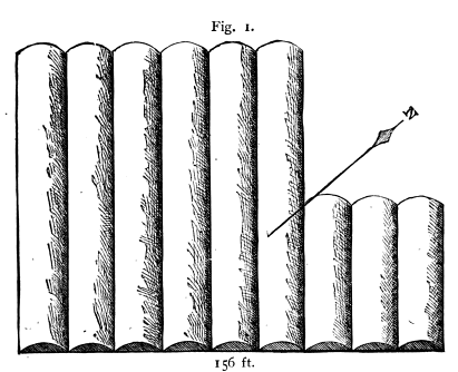
1. Wide convex beds, in parallel rows, without paths, composing independent plats. (Width of beds, 12 feet; paths, none; length, 74 to 115 feet.) Fig. 1.
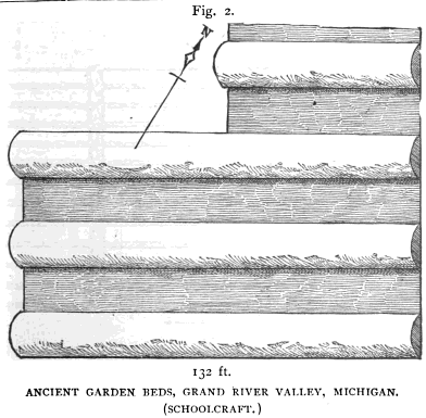
2. Wide convex beds, in parallel rows, separated by paths of same width, in independent plats (Width of bed, 12 to 16 feet; paths same; length, 74 to 132 feet.) Fig. 2.
3. Wide and parallel beds, separated by narrow paths, arranged in a series of plats longitudinal to each other (Width of beds, 14 feet; paths, 2 feet; length, 100 feet.) Fig. 3.

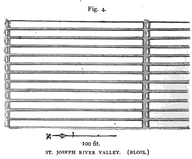
4. Long and narrow beds, separated by narrower paths and arranged in a series of longitudinal plats, each plat divided from the next by semi-circular heads. (Width of beds, 5 feet; paths, 1½ feet; length, 100 feet; height 18 inches.) Fig. 4.
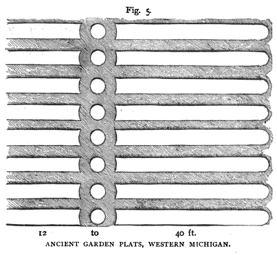
5. Parallel beds, arranged in plats similar to class 4, but divided by circular heads. (Width of beds, 6 feet; paths, 4 feet; length, 12 to 40 feet; height, 18 inches.) Fig. 5.
6. Parallel beds, of varying widths and lengths, separated by narrow paths, and arranged in plats of two or more at right angles N. and S., E. and W., to the plats adjacent. (Width of beds, 5 to 14 feet; paths, 1 to 2 feet; length, 12 to 30 feet; height, 8 inches.) Figures a, b, and c are varieties. Fig. 6.


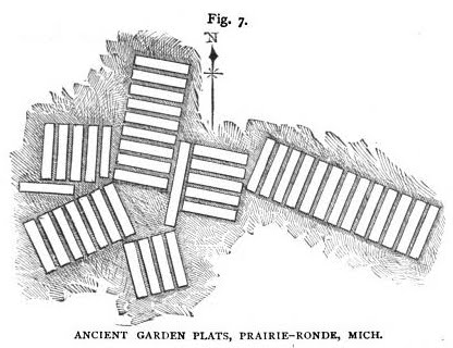
7. Parallel beds, of uniform width and length, with narrow paths, arranged in plats or blocks, and single beds, at varying angles. Width of beds, 6 feet; paths, 2 feet; length, about 30 feet; height, 10 to 12 inches.) Fig. 7.
8. Wheel-shaped plats, consisting of a circular bed, with beds of uniform shape and size radiating therefrom, all separated by narrow paths. (Width of beds, 6 to 20 feet; paths, 1 foot; length, 14 to 20 feet.) Fig. 8.

I present diagrams of each of these classes or kinds of beds. Of these only those numbered 1, 2 and 4 have ever before been delineated, to my knowledge. (See figures 1 to 8, pages 257-261.) Nos. 3 and 5 are described by Schoolcraft and Blois, while the others are figured as well – 1 and 2 by Schoolcraft and 4 by Blois. No. 3, according to the latter, consists of five plats, each 100 feet long, 20 beds in each plat. Schoolcraft does not give the exact localities, and I am unable to state whether beds of the same class have been noticed by other observers. As to their extent, his language is, “The beds are of various sizes, covering generally from 20 to 100 acres.” Some are reported to embrace even 300 acres. Plats of beds are undoubtedly here referred to.
Of the plat figured by Blois (No. 4), the writer says:
“They are found a short distance from Three Rivers, on one side of an oval prairie, surrounded by burr-oak plains. The prairie contains three hundred acres. The garden is judged to be half a mile in length by one-third in breadth, containing about one hundred acres, regularly laid out in beds running north and south, in the form of parallelograms, give feet in width and one hundred in length, and eighteen inches deep.”
The distinctive peculiarity of these beds is what Blois calls the “semi-lunar” head, at the extremity of each bed, separated from them by a path as represented.
Class 6, so far as my own inquiries warrant, represents the form and arrangement which is most common, viz.:
that of a series of parallel beds formed into blocks of two or more, alternating with other similar blocks placed at right angles to them. (See figures a, b, and c.) The prevailing width of the bed is five or six feet, and that of the paths one and a half to two feet. The length of the plats or blocks varies, the average being about twenty feet. Gardens of this kind were found by the early settlers of Schoolcraft, the burr-oak plains at Kalamazoo, Toland’s prairie, Prairie-Ronde, and elsewhere.
Mr. Henry Little says, that in 1831 they were very numerous on the plains where now stands the village of Kalamazoo; and south of the mound, eight or ten acres were entirely covered by them.
Mr. E. Laken Brown confirms this account, and says they reminded him of old New England gardens, being very regular and even, and the beds five feet by twelve or fourteen feet. In 1832 the outlines were very distinct, and the burr-oak trees on them as large as any in the vicinity. Mr. A. T. Prouty concurs as to the extent covered, but thinks the beds were six feet wide by twenty-five to forty long. On the farm of J. T. Cobb, section 7, town of Schoolcraft, the beds were quite numerous as late as 1860. There must have been 15 acres of them on his land. The “sets” would average five or six beds each. Neighbors put the number of acres covered with them in 1830, within the space of a mile, at one hundred.
Fig. 6-b, of class 6, is from a drawing by James R. Cumings, of Galesburg, of a garden in which the beds are of more than usual diversity in width and length. H. M. Shafter and Roswell Ransom, old settlers, say that three or four acres on the edge of the prairie, at this place, were covered with the beds. On the farm of the latter in the town of Comstock, of one hundred acres, there were not less than ten acres of beds, six feet by twenty-five to forty, arranged in alternate blocks, having a north-and-south and east-and-west direction.
Fig. 6-c is from a drawing by Mr. Shafter.
The series represented by Class 7 (fig. 7) were found at Prairie-Ronde. They are platted and described to me by Messrs. Cobb and Prouty. They differ from the more ordinary form of No. 6, in the arrangement of the blocks or sets of beds, which is here not at right angles, but at various and irregular angles, also in the single beds outlying. The number of beds in each block is also greater than usual.
Class 8 is established on the authority of Henry Little and A. T. Prouty, of Kalamazoo. The figure delineated is from the descriptions and dimensions given by the former. The diameter of the circular bed and the length of the radiating ones are each twenty-five to thirty feet. The latter describes two of similar design, but of smaller dimensions, the centre bed being only six feet in diameter, and the radiating ones twenty feet. All occurred at Kalamazoo, and in immediate association with the other forms of beds at that place, represented generally by Class 6.
There is reason for supposing that there may have existed another class of beds, differing altogether from any that I have represented, from expressions used by both Schoolcraft and Blois. The former speaks of “enigmatical plats of variously shaped beds;” and further, “nearly all the lines of each area or sub-area of beds are rectangular and parallel. Others admit of half circles and variously curved beds, with avenues, and are differently grouped and disposed.”
The latter says, the beds “appear in various fanciful shapes.” Some are laid off in rectilineal and curvilineal figures, either distinct or combined in a fantastic manner, in parterres and scolloped work, with alleys between, and apparently ample walks leading in different directions.”
This language is too vague to enable me to construct a diagram, nor have I any confirmation to offer from other sources. The reputation of the writers will not allow us to consider the descriptions fanciful, but it is possible to suppose they were misled by the representations of others.
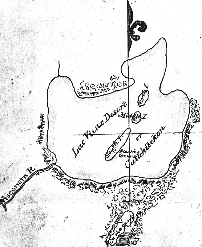
Lac Vieux Desert (‘lake of the old garden’) and Catakitekon [Gete-gitigaan (‘old gardens’)] from Thomas Jefferson Cram’s 1840 fieldbook. This is the headwaters of the Wisconsin River, and near those of the Wolf River and Ontonagon River.
~ School District of Marshfield: Digital Time Travelers
The principal crop of the Indians is maize, and this was never cultivated by them in rows, but in hills often large but always disposed in a very irregular manner. As little do these beds resemble the deserted fields of modern agriculture. On the other hand, the resemblance of many of the plats to the well-laid out garden beds of our own day is very striking; while the curvilinear forms suggest analogies quite as strong to the modern “pleasure garden.”
The nearest approach to anything resembling horticultural operations among Indian tribes, with the historic period, is noticed by Jones, who refers to a practice, among some of the southern Indians, of setting apart separate pieces of ground for each family. This author quotes from Captain Ribault’s “Discovery of Terra Florida,” published in London, 1563. “They labor and till the ground, sowing the fields with a grain called Mahis, whereof they make their meal, and in their gardens they plant beans, gourds, cucumbers, citrons, peas, and many other fruits and roots unknown to us. Their spades and mattocks are made of wood, so well and fitly as is possible.”
In the St. Joseph Valley I learned of numerous places, widely apart, where the labor and ksill of our ancient horticulturists were apparent in small gardens, laid out in different styles, and with an eye to the picturesque; as if each family had not only its separate garden patch, but had used it for the display of its own peculiar taste.
~ Bad River WPA Papers, Envelope 3, Folder 9.
~ Railroad History, Issues 54-58, pg. 26
Historians tell us of the Aztecs, that they had gardens in which were cultivated various plants, for medicinal uses, as well as for ornament. Was there something analogous to this in the Michigan Nation? Did the latter also have botanical gardens? May we accord to this unknown people a considerable advance in science, in addition to a cultivated taste, and an eye for symmetry and beauty, which is without precedent among the pre-historic people of this continent, north of Mexico?
These extensive indications of ancient culture necessarily imply a settled and populous community. We are led, therefore, to look for other evidences of the numbers and character of the people who made them. But here an extraordinary fact presents itself; such evidences are almost wanting! The testimony of nearly every one whom I have consulted – men who were among the first of the white race to break up the sod, that for ages had consecrated these old garden lands – agrees in the fact, that almost none of usual aboriginal relics were found; no pottery; no spear- and arrow-heads; no implements of stone; not even the omnipresent pipe. Tumuli, or burial mounds of the red man, are not uncommon, though not numerous, in Western Michigan, but have no recognized association with the garden race.
Upon the St. Joseph and Colorado rivers, and in the town of Prairie-Ronde, exist several small circular and rectangular embankments, resembling the lesser works of the Mound-Builders so numerous in Ohio. But no connection can be traced between these detached earthworks and the garden-beds. None of them seem to have been the bases of buildings, nor do they give indication of any religious origin or rites. There are no traces of dwellings, and the soil which has so sacredly preserved the labor of its occupants, discloses not even their bones!
At Three Rivers, and in Gilead, Branch County, are some ancient embankments, which are probably referable to this people and may pass for works of defence. That at the first named place was notably extensive. It consisted only of an earth embankment, about six feet in height, extending between two forks of a river, a mile apart. It thus enclosed a large area, and with a sufficient garrison might have withstood the siege of a large army of barbarous warriors.
It seems strange, indeed, that these garden beds, suggestive as they are, should be the only memorials of a race which has left such an evidence of civilized advancement, and was worthy of more enduring monuments! We may reasonably conclude, that they were a people of peaceable disposition, of laborious habits, and of æsthetic if not scientific tastes; that they lived in simple and patriarchal style, subsisting on the fruits of the earth, rather than of the chase. Their dwellings and their tools were of wood, and have perished. This simple record of their character and labors is all, it may be, we can ever know.
But is this all? May we not form some reasonable conjecture as to the period in which these gardeners lived?

Detail of “Chippewa Gardens” at Odanah from Narrative journal of travels from Detroit northwest through the great chain of American lakes to the sources of the Mississippi River in the year 1820, in 1820, by Henry Rowe Schoolcraft, page 105. This place is known as Gete Gititaaning (‘at the old gardens’) in Ojibwemowin.
“My children, I want you to listen to me. The proposition I am about to present will benefit all of you, and I need your cooperation. I would like to have you donate your labor to clear land for a large community garden, where every family, or any one who wishes can plant. The place I would suggest is that swampy flat, near the cemetery. It will take time to drain it and dry out but I know it will make good garden plats.“
~ Early Settlement of the Bad River Indian Reservation
A fact mentioned by Dr. Lapham furnishes a species of evidence, as to the relative antiquity of the garden beds of Wisconsin, as compared with the animal mounds. They were found overlying the latter; from which he infers, of course, a more recent origin. We may also suppose a considerable more recent age, since it is not likely that the race could have thus encroached upon the works of another, until long after these had been abandoned, and their religious or other significance forgotten.
The date of the abandonment of the beds may be approximately fixed, by the age of the trees found growing upon them. One of these mentioned by Schoolcraft, cut down in 1837, had 335 cortical layers. This carries the period back as far as 1502, or some years prior to the discovery of this country by the French. How long these labors were abandoned before this tree commenced its growth may not be susceptible of proof. Early French explorers do not appear to have been interested in the question, and it does not seem to me necessary to go further back than the three centuries during which that tree flourished, for a period quite long enough to have crumbled into indistinguishable dust every trace of wooden dwellings and implements, as well as of the bodies of their fabricators, if the latter received only simple earth burial.
(Anishinaabe Migration Story):
“In the Third Fire the Anishinabe will find the path to their chosen ground, a land in the west to which they must move their families. This will be the land where food grows upon the waters.”
~ The Mishomis Book – The Voice of the Ojibway by Edward Benton-Banai, Chapter 13 – The Seven Fires.
At the time of the arrival of the French the country was in possession of Algonquin tribes, who emigrated from the St. Lawrence about the middle of the 16th century. They were ignorant of the authors of these works, and were not more advanced in the arts of culture than the other known tribes.
It is probable that the few defensive works I have mentioned were erected by this settled and peaceful race of gardeners, as places of temporary refuge for the women and children, against the raids of the warlike tribes living eastward of them. The larger one may have served for the general defence in a time of sudden and great emergency. It is probable that on some such occasion they were surprised by their savage and relentless foes, and were overwhelmed, scattered or exterminated.
Most of the facts I have been able to present are gathered, in large part, from the memories – of course not always exact or reliable – of early settlers, and after modern culture had for many years obliterated the old.
It is perhaps useless to regret that these most interesting and unique relics of a lost people have so completely perished, through the greed of the dominant race; or that they could not have received, while they yet remained, the more exact and scientific scrutiny which is now being applied to the antiquities of our land. Much that might then have been cleared up, must now remain forever involved in mystery, or be left to conjecture.
– – – – – – – – – –
In September, 1885, the writer visited the region of the ancient garden beds, in hopes of being so fortunate as to find some remaining. He did discover, near Schoolcraft, on a plat of land which had been recently cleared of its timber, a few traces of beds belonging to a set, most of which had been broken up by the plough.
Four or five beds could be distinctly traced, for the distance of some ten to fifteen feet. The remainder of their lengths, said to be some twenty to thirty feet, had been obliterated by cultivation. Each bed had a width of about ten feet from centre to centre of the intervening paths. The latter had apparently a width of two or three feet, but it was impossible to define the exact outlines.
After much inquiry I could learn of no other place in or near Prairie-Ronde, or the plains of St. Joseph and Kalamazoo Counties, where any traces of the old garden beds remained.
Mr. Cobb informed me that about 1859 he endeavored to preserve portions of a set of these beds, which were well covered by touch, protective prairie sod. But when the white grub took possession of the turf thereabouts his ancient garden reserve did not escape. In a year or two the hogs, in their search for the grub, had so rooted and marred the outlines that he ploughed the beds up.
I found many old residents who well remembered the garden plats as they appeared a half century ago, and all concurred in the admiration excited by their peculiar character and the perfection of their preservation. Mr. Cobb says, he often took his friend to see his “ancient garden,” counted the beds, and speculated upon their object. The set of beds, which is shown only partially in his sketch (Fig. 7), contained thirteen beds, and was the largest of the sets. The others averaged five or six beds each.
All concurred, too, as to the great extent of land, amounting to several hundred acres, covered, wholly or partially, by the beds, chiefly upon the northern edge of the prairie. That all visible evidence of their existence should have so completely disappeared is not surprising to any one who notes their situation, upon the richest portions of the mixed prairies and plains. The lands most esteemed by their garden race were those which first attracted the modern farmer. These lands still constitute fields as beautiful as the eye can anywhere rest upon, and in a region second in loveliness to no other part of our country. The wants of the early settler almost preclude any care for the preservation of what was regarded as mere curiosities. Even when spared from the plough, and left to the care of nature, the absence of the annual fires, which had prevented the growth of timber; the roots of trees upheaving the beds; the decay of fallen timber; the hummocks caused by upturned roots; the destruction of the turf by the forest growth, and by cattle and hogs, all tend to deface the beds, and leave them to be reduced to the general level by the elements. Under these circumstances, a few years even would suffice to obliterate outlines which had remained almost unaltered for centuries.
Penokee Survey Incidents: Number IV
February 22, 2015
By Amorin Mello

December 8, 1877.
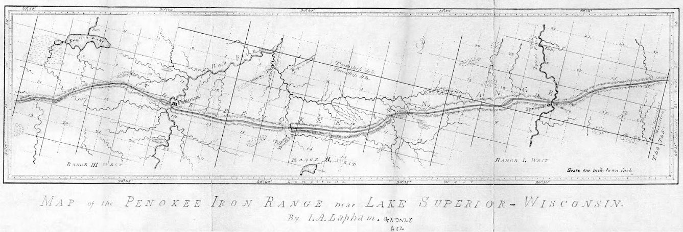
Increase Allen Lapham surveyed the Penokee Iron Range in September of 1858 for the Wisconsin & Lake Superior Mining and Smelting Company. Years later, Lapham’s experience was published as “Mountain of Iron Ore: The buried wealth of Northern Wisconsin“ in the Milwaukee Evening Wisconsin newspaper on February 21, 1887. (Image courtesy of the University of Wisconsin Geography Department)
~ 1978 Marsden Report for US Steel.
~ Railroad History, Issues 54-58, pg. 26
The Penoka Iron Range consists, as is well known, of a sharp ridge, some fifteen miles in length, by from one to one and one half in breadth, with a mean elevation of 700 feet above Lake Superior, from which is a distance about twenty-two miles, as the crow flies, its general trend being nearly east and west, it is densely covered with timber consisting of sugar maple, (of which nearly every tree is birdseye or curly) elm, red cedar, black, or yellow birch, some of which are of an enormous girth, among which are intermixed a few white pine and balsams, for it is traversed from north to south at three different points, by running streams, upon each of which the company had a station, the western being known in the vernacular of the company, as Palmer’s, (now Penoka); the center, as Lockwood’s, in honor of John Lockwood, who was at the time a prominent member of the Company, and upon its executive board; and the eastern, as Sidebotham’s, or “The Gorge.” These were the principal stations or centers, where supplies and men were always kept, and as which, as before stated, more or less work had been done the previous year. Penoka, as which the most work had been done, being considered by far the most valuable. This post was, at the time of my first visit, by charge of S.R. Marston, of whom mention was made in my last, and two young boys from Portsmouth, N.H., who had come west on exhibition, I should say, from the way they acted. They soon left, however, too many mosquitoes for them. “Lockwood’s,” as previously stated, was garrisoned by one man, whose name I have forgotten, and although a great amount of work had been done here as yet, it was nevertheless considered a very valuable claim, on account of the feasibility with which it could be reached by the rail Mr. Herbert had in contemplation to build from Ironton, and which would, in passing along the north side of the Range, come in close proximity to this station; besides, it had the additional advantages of a fine water power. At the east end were two half-breeds employed by the company, and George Chase, a young man from Derby, Vermont, a nephew of ex-Mayor Horace, and Dr. Enoch Chase, of Milwaukee, an employee of Stuntz, who, with James Stephenson, was awaiting the return of Gen. Cutler with reinforcements, in order to continue the survey. Chase subsequently made a claim which he was successful in securing – selling it finally to the Mr. Cogswell, of Milwaukee.
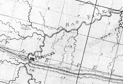
Penoka, aka Penokee, is Palmer’s station near the Bad River Gap.
It is also proper to state in addition to what has been already mentioned, that at, or about this time, a road was opened by Mr. Herbert’s order, from the Hay Marsh, six miles out from Ironton, to which point one had been previously opened, to the Range, which it struck about midway between Sidebotham’s and Lockwood’s Stations, over which, I suppose, the 50,000 tons as previously mentioned, was to find its way to Ironton, (in a horn). For this work, however, the Company refused to pay, as they had not authorized it; neither had Mr. Herbert, at that time, any authority to contract for it, except at his own risk; his appointment as agent having already been revoked; although his accounts had not, as yet, been fully settled. This work, which was without doubt, intended to commit the company still further in favor of Ironton as an outlet for the iron, was done by Samuel Champner, a then resident of Ashland and who if living is probably that much out of pocket today. No use was ever made of this road by the Company, not one of their employees, to my knowledge, ever passing over it.

The location of Lockwood’s station was not mapped by Lapham or by Stuntz. City Creek and Ballou Creek are the two water gaps on either side of Mount Whittlesey, midway between the gaps of Bad River and Tyler’s Fork.
This description will, I think, give your readers a very good understanding of the condition as well as the true inwardness of the affairs of the Wisconsin & Lake Superior Mining and Smelting Co., in the month of June, 1857.
At length, after remaining on the Range nearly three weeks, awaiting, Micawber like, for something to turn up, a change came with the arrival of Gen. Cutler from Milwaukee with the expected reinforcements. Mr. Herbert at once left the Range, went to Milwaukee and settled up with the Company, after which, to use a scriptural expression, “he walked no more with us.”

Springdale is Sidebotham’s station at The Gorge of Tyler Fork’s River.
“A special defense in contract law to allow a person to avoid having to respect a contract that she or he signed because of certain reasons such as a mistake as to the kind of contract.”
~ Duhaime.org
Wheelock, Smith, and McClellan were at once placed upon claims – McClellan in the interest of John Cummings, (whose name by an oversight was also omitted from the list of stockholders, given in my first paper), and Wheelock and Smith for the Company generally. Subsequently, A.S. Stacy, of Canada, was also employed to hold a claim. How well he performed this duty, will be seen further on. This done, the improvements necessary to be made in order to entitle us to the benefits of the preemption law were at once commenced. These improvements consisted of log cabins, principally, of which some twenty in all were erected upon the different claims. These cabins would have been a study for Michel Angelo, or Sir Christopher Wren. They had more angles than the Forty-seventh Problem of Euclid, with an average inclination of fifteen degrees to the Ecliptic. O, but they were “fearfully and wonderfully made,” were these cabins. Their construction embodied all the principle points of architecture in the Ancient as well as Modern–Milesian-Greek, mixed with the “hoop skirt” and Heathen Chimee. Probably ten dollars a month would have been considered a high rent for any of them. No such cabins as those were in exhibition at the Centennial, no sir. Rome was not built in a day, but most of these cabins were. I built four myself near the Gorge, in a day, with the assistance of two halfbreeds, but was not able to find them a week afterwards. This is not only a mystery but a conundrum. I think some traveling showman must have stolen them; but although they were non est we could swear that we had built them, and did.
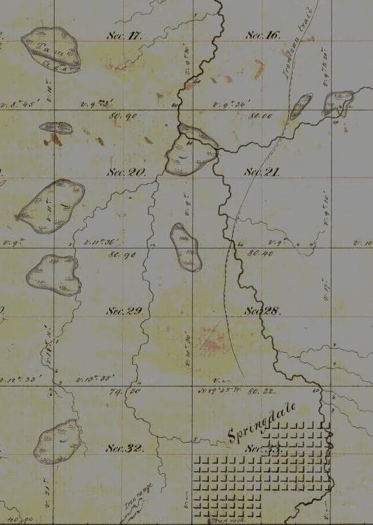
Springdale townsite plan at Sidebotham’s station by The Gorge of Tyler’s Fork in close proximity to the Ironton Trail and Iron Range. (Detail of Stuntz’s survey during August of 1857.)
Three were accordingly platted — one at Penoka, one at Lockwood‘s and one at the Gorge. And in order that it might be done without interfering with the regular survey, Gen. Cutler decided to place S.R. Marston who, in addition to his other accomplishments, claimed to be a full-fledged surveyor, in charge of the work, assisted by Wheelock, Smith and myself. He commenced at the Gorge, run three lines and quit, fully satisfied that he had greatly overestimated his abilities. We were certainly satisfied that he had. A drunken man could have reeled it off in the dark and come nearer the corner than he did. He was a complete failure in every thing he undertook. He left in the fall after the failure of the Sioux Scrip plot. Where he went I never knew. George E. Stuntz was subsequently put upon the work, which he was not long in doing, after which he rejoined Albert on the main work. This main work, however, for the completion of which we were all so anxious, was very much delayed, the cause for which we did not at the time fully understand, but we did afterwards. J.S.B.
