Treaty Allotments at Copper Falls
February 17, 2022
Collected & edited by Amorin Mello

Chippewa Treaty (blue) and Sioux Script (red) treaty land allotments in the Penokee Mountains located along mineral deposits near Mellen, Wisconsin.
[LaPointe County Register of Deeds: Volume 2 Deeds Page 419]

Julius Austrian had better success entering lands with Chippewa Certificates along the iron range for the Leopold & Austrian family’s La Pointe Iron Company than here along the copper range.
Be it known to all men that I Julius Austrian of Lapointe County State of Wisconsin am held and firmly Bound unto Julius [Bernault?], Peter King, Abraham Comartin, John W Bell & Henry Merryweather and to Each of them Separately in the Sum of One thousand Dollars for which payment will and truly to be made I bind my self my heirs executors and administrators firmly by these presents.
The condition of the above obligations are such that whereas the above mentioned Julius [Bernault?], Peter King, Abraham Comartin, John W Bell & Henry Merryweather having Squatted and improved the following mentioned Lands in Lapointe County with the intent of Claiming the Same as a Town Site namely the East half of Section No Seventeen (17) of Township number Forty five (45) of Range no two (2) and have agreed with the said Julius Austrian that he may enter the above described lands by Chippewa Script or otherwise at his option.

The “East half of Section No Seventeen (17) …” is where the Bad River and Tyler Forks River join spectacularly at what is now Brownstone Falls in Copper Falls State Park.
Now if the said Julius Austrian shall with due diligence enter the same as provided and obtain a Patent or Patents as Early as possible from the United States, and within 10 Days from the time he may procure and obtain said Patent or Patents for the above mentioned lands whether in his name or in the names of other parties, make execute & deliver or cause so to be done, to each of the above mentioned parties a Good & Sufficient Deed of warrantee clear of all incumbrances of an undivided Four ninetieths part of the whole mentioned East half of said Section no 17 as above specified. Then this obligation to be null & voice, otherwise to Remain in full force and virtue.
Given under my hand and seal at Lapointe this 30th day of April 1858.
Julius Austrian {Seal}
In presence of
Henry Smitz
M H Mandelbaum
State of Wisconsin } S.S.
County of Lapointe }
Personally came before the undersigned a Notary Public in & For the County of Lapointe the within named Julius Austrian to me well known who acknowledged that he did execute sign & seal the within Bond as his free Act and Deed.
{Seal} M H Mandelbaum
Notary Public
[Ashland County Register of Deeds: Volume 1 Deeds Pages 264-268]
{$180.00 Stamp Int Revenue U.S.}
This Indenture made the twenty fifth day of May in the year one thousand eight hundred and sixty four Between Louis Stein of the City and State of New York individually, Margaret Dupuis by Loius Stein her attorney, Charlotte Mercier by Louis Stein her attorney, Hypolite Auger by Louis Stein her attorney, Julia Renville by Louis Stein her attorney and Louise Moreau by Louis Stein her attorney, parties of the first part, and the Ashland Copper Mining Company, a Corporation created under and by virtue of the laws of the State of Wisconsin, party of the second part.
Whereas the north half of the North East quarter of Section Seventeen (17) in Township number Forty five (45) of Range Two (2) west in the District of Lands subject to Sale at Bayfield Wisconsin containing eighty acres according to the Government Survey was located on the 14th day of October 1863 with Chippewa Half Breed Scrip No 228 by John B Corbin,
and also the South Half of the North East Quarter of of Section Seventeen (17) Township Forty Five (45) Range Two (2) in the District of Lands subject to Sale at Bayfield Wisconsin containing eighty acres according to Government Survey was located on the 28th day of September 1863 with Chippewa Scrip Number 209 by John P Hamlin attorney for John Baptiste Denomie,
and also the North East half of South East quarter of Section Seventeen (17) Township Forty five (45) Range two (2) West in the District of Lands subject to Sale at Bayfield Wisconsin containing eighty acres according to the Government Survey was located October 14th 1863 with Chippewa Half Breed Scrip No 161 issued to John Haskins by John P Hamlin attorney,
and also the North East Quarter of South West quarter of Section Seventeen (27) Township Forty Five (45) Range Two (2) west in the District of lands subject to sale at Bayfield Wisconsin containing Forty acres according to the Government Survey was located October 20th 1863 with Sioux Scrip No 212 B by Louis Stein attorney for Margaret Dupuis,
And also the North West Quarter of South West quarter of Section Seventeen (17) Township number Forty five North of Range Two (2) West in the District of Lands subject to Sale at Bayfield Wisconsin containing Forty acres according to the Government Survey was located on November 25th 1863 with Sioux Half Breed Scrip No 102 B by Louis Stein attorney for Charlotte Mercier,
And also the South East Quarter of Section Eighteen (18) Township Forty five (45) North of Range Two (2) West in the District of Lands subject to Sale at Bayfield Wisconsin containing one hundred and sixty acres according to the Government Survey, was located on the 25th day of November 1863 with Sioux Half Breed Scrip No 487 C by Louis Stein attorney for Hypolite Auger,
And also the South half of South West Quarter of Section Seventeen (17) Township Forty five (45) Range Two (2) in the District of Lands subject to Sale at Bayfield Wisconsin containing eighty acres according to the Government Survey was located October 18th 1863 with Sioux Half Breed Scrip No 212 Letter C by Louis Stein attorney for Margaret Dupuis,
And also the North half of the North West quarter of Section Twenty (20) Township Forty five (45) North of Range 2 west in the District of lands subject to Sale at Bayfield Wisconsin containing eighty acres according to the Government Survey was located September 10th 1863 with Chippewa Half Breed Scrip No 158 by Julius Austrian attorney,
And also the South Half of South East Quarter of Section Seventeen (17) Township Forty five (45) Range Two (2) West in the District of Lands subject to Sale at Bayfield Wisconsin containing eighty acres according to the Government Survey was located on the 14th day of October 1863 with Chippewa Half Breed Scrip No 281 issued to Michael Lambert by John P Hamlin attorney,
And also the North East quarter of Section nineteen (19) Township No Forty five (45) Range Two (2) West in the District of Lands subject to Sale at Bayfield Wisconsin containing one hundred and Sixty acres according to the Government Survey was located on the 19th day of October 1863 with Sioux Half Breed Scrip No 29 by Louis Stein attorney for Julia Renville,
And also the North half of South East quarter and East Half of the South West quarter of Section Number nineteen (19) Township No Forty five (45) Range Two (2) West in the District of Lands subject to Sale at Bayfield Wisconsin containing One hundred and Sixty acres according to the Government Survey was located on the 19th day of October 1963 with Sioux Half Breed Scrip No 17 C by Louis Stein attorney for Louise Moreau.
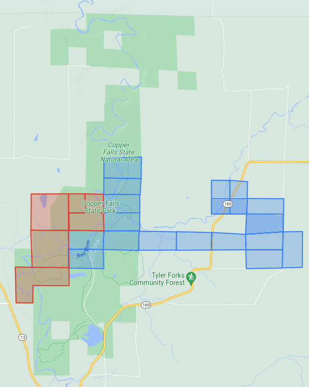
Chippewa and Sioux treaty land allotments in and contiguous to Copper Falls State Park. There are more Chippewa allotments here than those claimed by Ashland Copper Mining Company. Others went to Robert Morrin, Joseph Roy, Francis S. Gurnoe, John Chapman, Francis Fournier, Rosalie Trocquer, John Baptiste Visneau, Henry Davenport, Edward Ashman, Henry Graham, Mary Graham, Joseph Blanchard, and Reuben Chapman.
And whereas said North Half of North East Quarter of Section Seventeen (17) in Township No Forty five (45) of Range Two west was conveyed by John B Corbin and Wife to John P Hamlin by Deed dated October 17th 1863, and Recorded in the Office of Register of Deeds of Ashland County Wisconsin in Book of Deeds Vol 1 pages 218 & 219 October 18, 1863 and was further conveyed by said John P Hamlin to Louis Stein by Deed dated October 31st 1863, and Recorded in said Registers office in Book of Deeds Vol 1 Page 225 November 9th 1863,

John Baptiste Denomie Jr of Odanah; son of allottee Jean Baptiste Denomie Sr.
~ Noble Lives of a Noble Race, A Series of Reproductions by the Pupils of Saint Mary’s, Odanah, Wisconsin, 1909, page 213-217.
And whereas said South Half of the North east quarter of Section Seventeen (17) Township Forty five (45) Range Two (2) has been conveyed by the said John Baptiste Denomie to Louis Stein by Deed dated May 25th 1864,
and said North East Half of South East Quarter of Section Seventeen (17) Township Forty five (45) Range Two(2) west has been conveyed by said John Haskins to said Louis Stein by Deed dated May 25th 1864,
and said South East Quarter of Section Eighteen (18) Township Forty five (45) North of range two (2) west has been conveyed by Hypolite Auger to said Louis Stein by Deed Dated January 1, 1862 and recorded in said Office of Register of Deeds in Vol 1 of Deeds page 227 January 23 1864,

The Ashland Copper Mine was mapped by Irving in 1873 for the Geology of Wisconsin: Volume III. This was located at what is now the main picnic area on Michael Lambert’s Chippewa Allotment in Copper Falls State Park.
and said South Half of South East quarter of Section Seventeen (17) Township Forty five (45) Range two (2) West has been conveyed by the said Michael Lambert to the said Louis Stein by Deed dated May 25th 1864,
and the said Louis Stein has also acquired the title of the said North Half of the North West quarter of Section twenty (20) Township Forty five (45) North of Range two (2) West from the said Julius Austrian.
And whereas the said parties of the first part to these presents have sold and agreed to convey to the said party of the second part to these presents a tract of land situated in the County of Ashland in the State of Wisconsin which includes the whole or parts of the several tracts pieces and parcels of land herein before described which said tract of land so sold and agreed to be conveyed to the said party of the second part is hereinafter particularly described.
Now Therefore this Indenture Witnesseth that the said parties of the first part for and in consideration of Twenty thousand shares of the Capital Stocks of the said party of the second part of the value of five dollars for each Share, which have been issued or transferred and assigned to them the said parties of the first part or as they have appointed and directed, the receipt of which is hereby acknowledged, have granted, bargained, sold, released, conveyed, and confirmed and by these presents do grant, bargain, sell, release, convey and confirm unto the said party of the second part its successors and assigns forever

Copper Falls by Emily Fritts, August 2016.
~ WikiMedia Commons
All that certain tract and parcel of Land situate, lying and being in the County of Ashland in the State of Wisconsin, known bounded and described as follows to wit;
Beginning at a point in the center of Bad River in Township Number Forty five (45) North Range Number Two (2) West of the Fourth Meridian where said river crosses the northerly boundary of Section number Seventeen (17) in the North East quarter, thence running west eight hundred (800) feet more or less to the North West corner of said North East quarter Section; thence South twenty six hundred and forty (2640) feet to the center of Section number Seventeen (17); thence West Five thousand two hundred and eighty feet (5280) to the center of Section number eighteen (18); thence South Five thousand two hundred and eighty (5280) feet to the center of Section number nineteen (18); thence west thirteen hundred and twenty (1320) feet; thence South twenty six hundred and forty (2640) feet; thence East thirteen hundred and twenty (1320) feet; thence North twenty three hundred and ninety (2390) feet more or less to the center of said Bad River and thence North Easterly along the center of said Bad River as it runs to the place of beginning, containing six hundred and fifty three acres (653) more or less and being portions of Section numbers seventeen (17), eighteen (18), nineteen (19) and twenty (20) in the aforesaid Township.

Brownstone Falls in Copper Falls State Park by Yinan Chen.
~ WikiMedia Commons
To have and to hold the above described and hereby granted premises and every part and parcel thereof together with all and singular the tenements hereditaments and appurtenances thereunto belonging or in anywise appertaining unto the said party of the second part its successors and assigns to its and their own purpose, use, benefit and behoof forever. And the said parties of the first part severally for himself and herself and not the one for the other, and for his and her heirs executors and administrators do hereby covenant promise and agree to and with the said party of the second part, its successors and assigns to make, execute, sign, seal, acknowledge and deliver at the Cost and expense of the said party of the second part its successors and assigns all such other and further Deeds, grants, conveyances and instruments in writing as the said party of the second part its successors and assigns or its or their Counsel learned in the law shall at any times advise, devise or require for the [more?] effectually conveying to and vesting in the said party of the second part its successors and assigns the fee simple of the above described and hereby granted, promised and every part thereof with the appurteances. And the said Margaret DuPuis, Charlotte Mercier, Hypolite Auger, Julia Renville and Louise Moreau severally and not the one for the other and each of them only in respect to so much of the hereby conveyed premises as is located by or for him or her as herein before stated and set forth and is hereby conveyed by him or her or intended so to be for himself and herself, his and her heirs, executors and administrators covenant and agree to and with the said party of the second part its successors and assigns in the manner and form following that is to say That he or she at the time of the ensealing and delivery of these presents is the true, lawful and rightful owner of the said hereby conveyed premises, and has therein a good sure, perfect and indefeasible estate in fee simple; and that he and she has full right, power and authority to grant, bargain, sell, remise, release, convey and confirm the said premises unto the said party of the second part its successors and assigns in manner and form aforesaid and that the said party of the second part its successors and assigns shall quietly enjoy and possess the said premises and that he and she will Warrant and Defend the title to the same against all lawful claims.
In Witness Whereof the said parties of the first part have hereunto set their hands and Seals they day and year first above written
Louis Stein {S.S.}
Margaret Dupuis by Louis Stein atty {S.S.}
Charlotte Mercier by Louis Stein atty {S.S.}
Hypolite Auger by Louis Stein attorney {S.S.}
Julia Renville by Louis Stein Attorney {S.S.}
Louis Moreau by Louis Stein attorney {S.S.}
Sealed and delivered in Presence
A H Wallis
Andrew Clerk
State of New York } S.S.
County of New York }
Be it Remembered that on this seventh day of June in the year eighteen hundred and sixty four before the subscriber a Commissioner in and for the said State, appointed by the Governor of the State of Wisconsin to take acknowledgment and proof of the execution of Deeds, or other conveyances or leases and of any contract, letter of attorney or other writing under seal or not administer oaths and take and certify depositions to be used or recorded in the said State of Wisconsin appeared Louis Stein whom I know to be the person described in and who executed the foregoing instrument and acknowledged that he executed the same in his own behalf as his own act and deed and also acknowledged that he executed the same as the act and deed of Margaret Dupuis, Charlotte Mercier, Hypolite Auger, Julia Renville & Louise Moreau therein descried by virtue of a Power of Attorney severally executed by them authorizing the same, and which Power of Attorney have been duly exhibited to me by the said Louis Stein.
Given under my hand and Official Seal
{Seal} Charles E Jenkins Commissioner for the State of Wisconsin, residing in the city of New York.
Tyler’s Fork Location: Copper Lands
March 19, 2016
By Amorin Mello

“Map and Section Showing the Formations at the Junction of Bad River and Tylers Fork” by R. D. Irving, 1873. Reproduced from the Geology of Wisconsin: Volume III.
LETTER OF J. A. BAILEY, ESQ.,
IN REFERENCE TO THE
TYLER’S FORK PROPERTY.
———–
Office of Ashland Copper Mining Company,
Ashland County, Wis., Oct. 20, 1864.
Messrs. A. Whittlesey F. W. Bartlett,
Gentlemen:

“Asaph Whittlesey dressed for his journey from Ashland to Madison, Wisconsin, to take up his seat in the state legislature. Whittlesey is attired for the long trek in winter gear including goggles, a walking staff, and snowshoes.” Circa 1860.
~ Wisconsin Historical Society
I have made an examination of the trap beds exposed between this and your location, upon the Copper Range, in Sections 15, 16 and 21, Town 45, North, Range 2, West, in this County, and have collected specimens (which are herewith forwarded) from the Ashland Company’s location, and from various points Eastward to your location.
The accompanying sketch of the territory referred to will assist you in locating the several points from which these specimens were taken, the figures upon the sketch indicating the points referred to.
Detail of the Ashland Copper Mine from 1873; located around what is now the main picnic area within Copper Falls State Park.
The specimens No. 1, are from the rocks in place in the bed of the West branch of Bad River, above the falls, near shaft No. 1, and contain a good per centage of native Copper. The copper bearing belt, exposed here across the formation, embraces a breadth of about 500 feet.
Specimens No. 2, are vein rock, from the transverse vein, in which our shaft No. 1 is being sunk. This shaft is now 35 feet deep, carrying small quantities of fine Copper all the way.
Specimens No. 3, are from the outcrop of the Herbert vein, near the junction of the East and West branches of Bad River, containing “gray ore,” or “gray sulphuret of copper.”
Specimens Nos. 4, 5 and 6 are of trap, taken from the rock in place, along Tyler’s Fork, at the points indicated on the sketch of corresponding numbers.
My explorations and survey have been extended only to a short distance East of the Section line dividing Sections 16 and 17.
The surveys have been carefully made with theodolite and chain, with the view to determine the true course of the copper bearing belt through the “Ashland Company’s” property, and that adjoining on the East; and as near as I can determine from the measurements and the character of the rocks exposed, the course of this belt is East and West, or nearly so, through Section 17, with indications of a curve to the Northward, as we approach to, and enter Section 16.
I have indicated on the sketch the position of what I consider the North line of the outcrop of the copper bearing belt. The South line is not determined, the rocks being covered by drift, sand, &c.
It will be proper for me to add that the productive trap formation, found in place above the falls, in the West branch, corresponds fully with the formation at the same elevation in Tyler’s Fork, on the Western boundary of Section 16; and I am clearly of the opinion that at that point the trap formation, when penetrated to a depth corresponding to that at the falls of the West branch, will be alike productive of copper, and that the most productive veins will be found running parallel with the formation.
Very respectfully, Yours, &c.,
J. A. BAILEY,
Supt. & Engineer A. C. M. Co.
—————-
A letter from Mr. E. Leehy, of Bad River Falls, dated Jan’y 6, 1865, states that in shaft No. 2, on the Ashland mine, several hundred feet South of No. 1, and in the productive belt, the copper rock was reached at 20 feet in depth, and the first blast threw out several pounds of native copper in pieces from the size of an egg down.

“Property on which ‘Silver Lead’ has recently been discovered.”
TYLER’S FORK LOCATION.
——-~~0~~——-
COPPER LANDS,
IN
SECTIONS 15 16 AND 21, TOWN 45, NORTH, RANGE 2, WEST.
640 ACRES.
ASHLAND COUNTY, WISCONSIN.

Detail of Township 45 North, Range 2 West, from Charles Whittlesey’s 1860 Geological Map of the Penokie Range.
This location covers a great part, if not all of the breadth of the productive trap formation. The outcrop of the strata is here nearly East and West, with a curve to the North-Eastward on or near this land. The greatest length of the location is North and South, and therefore crosses the formation nearly at right angles. At the Northern end, is the conglomerate and sand rock, which overlies the trap beds. These beds are better exposed at the West, in Section 17, on the Ashland Copper Company’s land, where they are now working and whatever developments may be made there will apply to this property. The strata have a sharp dip to the North, and are thus exposed at the edges, being nearly vertical. Next below, and South of the conglomerate, is a band of black and red trap, of a compact and rather flinty structure, about three hundred (300) feet thick, in which there are numerous transverse veins, cutting the strata at various angles. These are visible in a deep gulf formed on both forks of Bad River, that unite in Section 17. Somme of these cross veins carry copper, both native and as an ore in the form of grey sulphuret. They also carry as vein matter, chlorite, cale, spar, and flucan, or red and green magnesian clay. There are also narrow beds of trap, interstratified with the hard ores, which are softer, owing to a large portion of laumonite. I do not regard the true veins in the upper beds, as likely to furnish mining ground; but as highly valuable indications, which are to be followed into the more promising strata lower down in the system. Next below the hard beds, to the South, is a belt of trap rocks, whose composition and texture I regard as highly favorable.
The Ashland Company is sinking on a cross or transverse vein, at the Southern border of the hard beds; which in the course of 75 or 100 feet along their inclined shaft, will enter what I consider productive ground. The thickness of this ground is not determined, but what I have seen in the branches of the river exceeds half a mile. It is not, however, all alike, as there are in it layers possessing different characters, corresponding in this respect other parts of the trap range in Michigan and Wisconsin.
The stratum at the head of the falls, on the West fork, where the Ashland Company is at work, has been closely examined over a breadth of about 50 feet, and carries small pieces or nuggets of native copper throughout. It is a soft brown amyglaloid, which small bunches of chlorite, spar and laumonite; some prehnite and quartz, in which the copper is found. Lumps weighing one to two pounds have been obtained from this bed away from any appearances of a vein. This is the general character of the mineral belt on Section 17, which I consider as the true mining ground of this part of the range. All these beds are embraced in our location, at a distance of ¼ to ⅓ of a mile on the East. In Sections 16 and 21, the exposure of rock is not as extensive as it is upon 17, for the rocks are covered by drift clay, sand and gravel, except in the streams.
There is no canoe navigation on Tyler’s Fork, or the Upper Bad River, so swift is the current and narrow and crooked are the channels.
Tyler’s Fork comes out of the mountains about twelve miles southeast by south from Woods’s [at Leihy’s Saw Mill], in a chasm, two hundred feet deep deep, in the red sand-rock and conglomerate. The junction of its ten branches takes place in this narrow gulf or ‘cañon,’ the eastern branch making a plunge of forty-two feet, succeeded, as you ascend, by a series of chutes over trap-rocks forty feet in one-fourth of a mile. Mr. D. Tyler, of the Charter Oak Company, made a location here, and built a rude cabin at the edge of the falls.”
Geological Report on That Portion of Wisconsin Bordering on the South Shore of Lake Superior. Surveyed in the Year 1849, Under the Direction of David Dale Owen, United States Geologist, by Charles Whittlesey, Head of Sub-Corps, page 433.
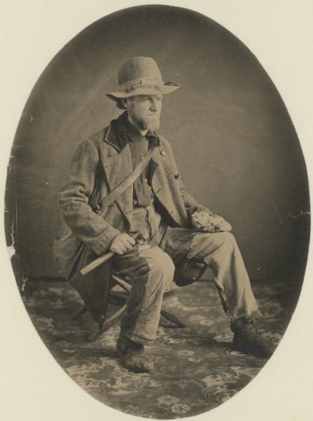
“Studio portrait of geologist Charles Whittlesey dressed for a field trip.” Circa 1858.
~ Wisconsin Historical Society
The East, or “Tyler’s” Fork, shows the trap beds in its channel a large part of the way through Section 16; and they are visible in the small creek that empties into it on Section 21, from the South. To examine the metal-bearing bed, of which I have spoken, after it reaches this location, the rocks must be uncovered by trenches or shafts in the sand and gravel, after having determined the true course of the bed. The search for cross veins can be easily made in the channel of Tyler’s Fork. This is a stream of considerable value for water power, the fall in your property being sufficient for two dams, and the flow of water sufficient for a saw mill. The Exploration of the porous laumonite beds, will be somewhat tedious; but the close proximity to those on the Ashland Company’s property will be of great assistance. As soon as it is demonstrated that these deposits of fine and nugget copper are remunerative at one point on the range, it gives new value to the whole system. Copper deposited in this mode, in other mining districts, has been found to be more uniform over long distances, than it is in veins; because these ores are liable to pass out of the property formations, and into a diabase rock. These copper-bearing longitudinal courses should therefore be most thoroughly searched. In this region, stamp mills can be worked in most cases by water power; a heavy and regular bed can be stoped and broken up ready for the mill, at a much cheaper rate per fathom, than vein matter. The improved stamps, crushers and washers, have of late years much reduced the expence of working mineral-bearing rock. The absence of masses of native copper in the Ashland district, is not now so important as it was when the first explorers made their location here. On this property, the length of the copper-bearing beds is something over a mile, and their breadth at least half a mile. As they extend to a greater depth than any mine can be worked, there is no fear of exhaustion.
CHAS. WHITTLESEY
Geologist and Mining Engineer.
Cleveland, Ohio, Jan. 1st, 1865.
