Opinike (or Potatoe) River Property
March 20, 2016
By Amorin Mello

“Map Showing the Succession of Layers Along Potato River” by R. D. Irving, 1873. Reproduced from the Geology of Wisconsin: Volume III.

OPINIKE
(OR POTATOE)
RIVER PROPERTY,
TOWN 46, NORTH RANGE 1, WEST, SECTIONS 16 & 17,
480 ACRES,
ASHLAND COUNTY, WISCONSIN.
————–

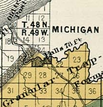
Detail of the Opinike River Property and the Ironton trail in Township 45 North, Range 1 West, from Charles Whittlesey’s 1860 Geological Map of the Penokie Range.
The “Charter Oak” Mining Company occupied these premises in 1845-6 under permits from the government. The reports of the agents of the Company at that time state that copper bearing veins were found in the trap rocks next above the lower Falls. In geological characters and position, the rocks are the same here as at the Upper Falls of the Montreal, herein described. Next below the sandstone is the same black slate; below this the conglomerate, then alternating bands of sandstone and trap, and beneath them the main body of brown and amygdaloid trap. Like the Montreal River beds, they are here tilted up at a high angle to the North-west, their line of outcrop bearing North-east. They are, however, reduced in thickness materially, the conglomerate being about 600 feet, and the bands f sandstone are fewer in number. over the conglomerates, and over the trap, there are several falls and chutes in the river, amounting to 125 or 130 feet in a mile.
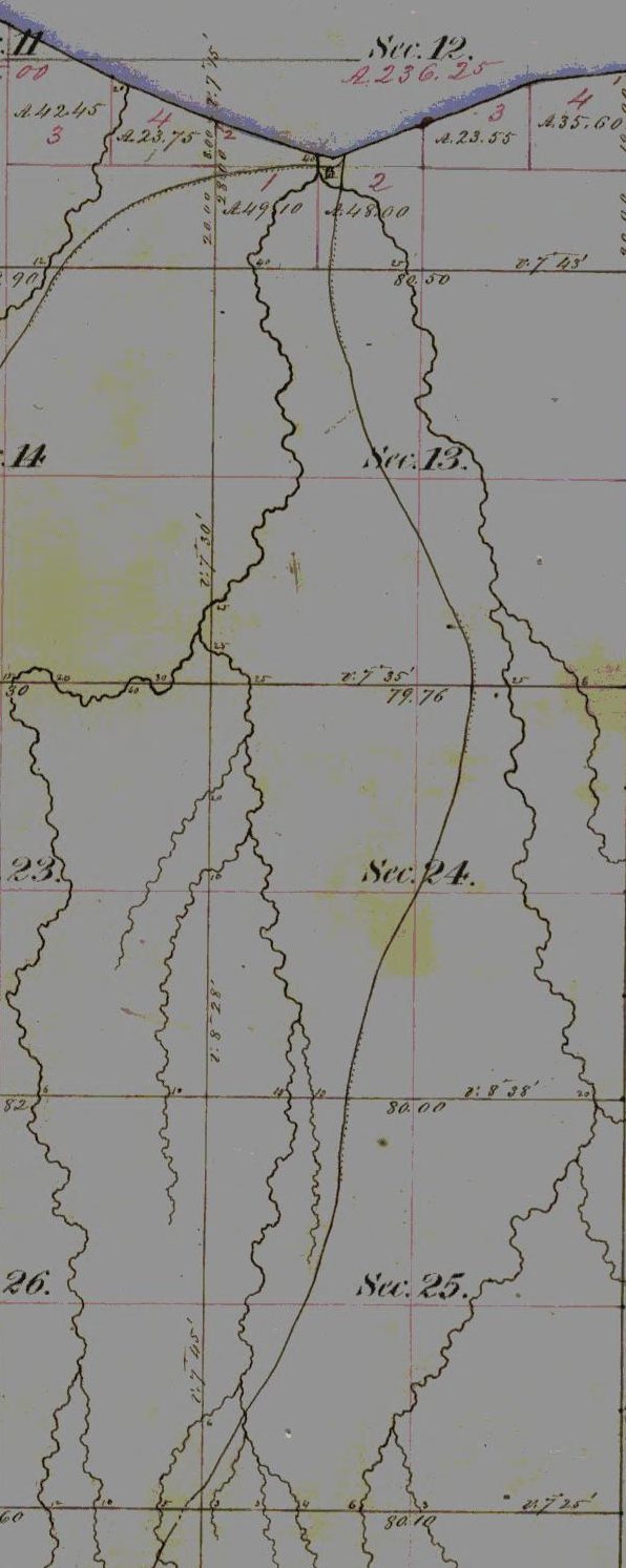
Detail of the Upper Falls (Saxon Falls) on the Montreal River and the Old Flambeau Trail in Township 47 North, Range 1 East from Charles Whittlesey’s 1860 Geological Map of the Penokie Range.
Here, as at the Montreal, the best trap is above the chutes, where it is well exposed in the channel of the river. For one mile above the Lower Falls the trap is of a favorable character ; but above this is not visible until the old Ironton trail is reached. The thickness of the productive trap is not as great as it is at the Montreal River. I judge that this tract covers the entire breadth of the soft brown amygdaloid trap. So far as I can form an opinion from the eternal character of the rocks, they promise as well as any part of this range. No part of the ground has been tested by recent explorations for veins, but there is abundant encouragement for a thorough trial. It must be remembered that it is only in the streams that the rocks composting the best part of this copper range are visible. From the Montreal to the Opinike River, neither the conglomerate nor the trap rises above the level of the country. From the Opinike to the forks of Bad River on Section 17, Town 45, Range 2, West, a distance South-easterly of about nine (9) miles, the productive belt of trap does not show itself above the drift materials, which over the country. The process of exploration is therefore much more tedious than it would be if the uplift was elevated into a high mountain ridge, with rocky cliffs exposed to view.
Ironton is the proper landing for works at the Opinike Falls, as well as for the Montreal River, and the distance is about nine miles. About two miles up the river, the Ironton trail to the Iron Range, crosses the River Opinike. It is highly probable the Ashland Copper Mining Company, which is now at work at the forks of Bad River, will seek an outlet this way. Although there is not a natural harbor at Ironton Landing, there is an angle in the cast which gives shelter to all but Northern winds, and the deep water approaches near the shore. Piers that were sunk there in 1857, have not yet been moved from their foundations by storms or by floating ice. This is the natural outlet for that part of the Iron Range which is East of the Penokie Gap. Although the country is somewhat mountainous, there are no serious obstacles to prevent highways, plank-roads or railroads from being built. Whatever mines may be developed on either the Copper or the Iron Range East of the Bad River, will find this the most convenient route to reach the lake. The water-power of the Opinike is at the upper chutes twenty-eight (28) feet and the lower seventy-five (75) feet – the latter being over the conglomerate rock and the former over trap. It is about three-fourths of a mile between them, and in the distance the river is rapid over a rocky bed. There is sufficient timber on the tract for all mining purposes, and a portion of the soil is equal to any in the country.

Detail of Ervin “Nigigoons” Leihy’s saw mill.
From the falls of the Opinike to Lehy’s saw-mill, at the falls of Bad River, is about nine (9) miles, in a North-westerly direction. Batteaux can reach Lehy’s mill from the lake during the ordinary stage of water. There is an Indian trail from Lehy’s to the falls, over a level country, somewhat more feasible for a road than the route to Ironton, but for the purposes of a mine the Ironton landing is much preferable. The flow of water in the Opinike is not equal to that of the Montreal, but the total fall is greater. Should workable mineral be found here – as appearances lead me confidently to anticipate – the location has advantages of position and water-power such as to place it next the Montreal River property for economical mining.
CHAS. WHITTLESEY,
Geologist and Mining Engineer.
Cleveland, Jan’y 1st, 1865.
Tyler’s Fork Location: Copper Lands
March 19, 2016
By Amorin Mello

“Map and Section Showing the Formations at the Junction of Bad River and Tylers Fork” by R. D. Irving, 1873. Reproduced from the Geology of Wisconsin: Volume III.
LETTER OF J. A. BAILEY, ESQ.,
IN REFERENCE TO THE
TYLER’S FORK PROPERTY.
———–
Office of Ashland Copper Mining Company,
Ashland County, Wis., Oct. 20, 1864.
Messrs. A. Whittlesey F. W. Bartlett,
Gentlemen:

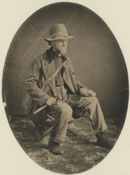
“Asaph Whittlesey dressed for his journey from Ashland to Madison, Wisconsin, to take up his seat in the state legislature. Whittlesey is attired for the long trek in winter gear including goggles, a walking staff, and snowshoes.” Circa 1860.
~ Wisconsin Historical Society
I have made an examination of the trap beds exposed between this and your location, upon the Copper Range, in Sections 15, 16 and 21, Town 45, North, Range 2, West, in this County, and have collected specimens (which are herewith forwarded) from the Ashland Company’s location, and from various points Eastward to your location.
The accompanying sketch of the territory referred to will assist you in locating the several points from which these specimens were taken, the figures upon the sketch indicating the points referred to.

Detail of the Ashland Copper Mine from 1873; located around what is now the main picnic area within Copper Falls State Park.
The specimens No. 1, are from the rocks in place in the bed of the West branch of Bad River, above the falls, near shaft No. 1, and contain a good per centage of native Copper. The copper bearing belt, exposed here across the formation, embraces a breadth of about 500 feet.
Specimens No. 2, are vein rock, from the transverse vein, in which our shaft No. 1 is being sunk. This shaft is now 35 feet deep, carrying small quantities of fine Copper all the way.
Specimens No. 3, are from the outcrop of the Herbert vein, near the junction of the East and West branches of Bad River, containing “gray ore,” or “gray sulphuret of copper.”
Specimens Nos. 4, 5 and 6 are of trap, taken from the rock in place, along Tyler’s Fork, at the points indicated on the sketch of corresponding numbers.
My explorations and survey have been extended only to a short distance East of the Section line dividing Sections 16 and 17.
The surveys have been carefully made with theodolite and chain, with the view to determine the true course of the copper bearing belt through the “Ashland Company’s” property, and that adjoining on the East; and as near as I can determine from the measurements and the character of the rocks exposed, the course of this belt is East and West, or nearly so, through Section 17, with indications of a curve to the Northward, as we approach to, and enter Section 16.
I have indicated on the sketch the position of what I consider the North line of the outcrop of the copper bearing belt. The South line is not determined, the rocks being covered by drift, sand, &c.
It will be proper for me to add that the productive trap formation, found in place above the falls, in the West branch, corresponds fully with the formation at the same elevation in Tyler’s Fork, on the Western boundary of Section 16; and I am clearly of the opinion that at that point the trap formation, when penetrated to a depth corresponding to that at the falls of the West branch, will be alike productive of copper, and that the most productive veins will be found running parallel with the formation.
Very respectfully, Yours, &c.,
J. A. BAILEY,
Supt. & Engineer A. C. M. Co.
—————-
A letter from Mr. E. Leehy, of Bad River Falls, dated Jan’y 6, 1865, states that in shaft No. 2, on the Ashland mine, several hundred feet South of No. 1, and in the productive belt, the copper rock was reached at 20 feet in depth, and the first blast threw out several pounds of native copper in pieces from the size of an egg down.

“Property on which ‘Silver Lead’ has recently been discovered.”
TYLER’S FORK LOCATION.
——-~~0~~——-
COPPER LANDS,
IN
SECTIONS 15 16 AND 21, TOWN 45, NORTH, RANGE 2, WEST.
640 ACRES.
ASHLAND COUNTY, WISCONSIN.

Detail of Township 45 North, Range 2 West, from Charles Whittlesey’s 1860 Geological Map of the Penokie Range.
This location covers a great part, if not all of the breadth of the productive trap formation. The outcrop of the strata is here nearly East and West, with a curve to the North-Eastward on or near this land. The greatest length of the location is North and South, and therefore crosses the formation nearly at right angles. At the Northern end, is the conglomerate and sand rock, which overlies the trap beds. These beds are better exposed at the West, in Section 17, on the Ashland Copper Company’s land, where they are now working and whatever developments may be made there will apply to this property. The strata have a sharp dip to the North, and are thus exposed at the edges, being nearly vertical. Next below, and South of the conglomerate, is a band of black and red trap, of a compact and rather flinty structure, about three hundred (300) feet thick, in which there are numerous transverse veins, cutting the strata at various angles. These are visible in a deep gulf formed on both forks of Bad River, that unite in Section 17. Somme of these cross veins carry copper, both native and as an ore in the form of grey sulphuret. They also carry as vein matter, chlorite, cale, spar, and flucan, or red and green magnesian clay. There are also narrow beds of trap, interstratified with the hard ores, which are softer, owing to a large portion of laumonite. I do not regard the true veins in the upper beds, as likely to furnish mining ground; but as highly valuable indications, which are to be followed into the more promising strata lower down in the system. Next below the hard beds, to the South, is a belt of trap rocks, whose composition and texture I regard as highly favorable.
The Ashland Company is sinking on a cross or transverse vein, at the Southern border of the hard beds; which in the course of 75 or 100 feet along their inclined shaft, will enter what I consider productive ground. The thickness of this ground is not determined, but what I have seen in the branches of the river exceeds half a mile. It is not, however, all alike, as there are in it layers possessing different characters, corresponding in this respect other parts of the trap range in Michigan and Wisconsin.
The stratum at the head of the falls, on the West fork, where the Ashland Company is at work, has been closely examined over a breadth of about 50 feet, and carries small pieces or nuggets of native copper throughout. It is a soft brown amyglaloid, which small bunches of chlorite, spar and laumonite; some prehnite and quartz, in which the copper is found. Lumps weighing one to two pounds have been obtained from this bed away from any appearances of a vein. This is the general character of the mineral belt on Section 17, which I consider as the true mining ground of this part of the range. All these beds are embraced in our location, at a distance of ¼ to ⅓ of a mile on the East. In Sections 16 and 21, the exposure of rock is not as extensive as it is upon 17, for the rocks are covered by drift clay, sand and gravel, except in the streams.
There is no canoe navigation on Tyler’s Fork, or the Upper Bad River, so swift is the current and narrow and crooked are the channels.
Tyler’s Fork comes out of the mountains about twelve miles southeast by south from Woods’s [at Leihy’s Saw Mill], in a chasm, two hundred feet deep deep, in the red sand-rock and conglomerate. The junction of its ten branches takes place in this narrow gulf or ‘cañon,’ the eastern branch making a plunge of forty-two feet, succeeded, as you ascend, by a series of chutes over trap-rocks forty feet in one-fourth of a mile. Mr. D. Tyler, of the Charter Oak Company, made a location here, and built a rude cabin at the edge of the falls.”
Geological Report on That Portion of Wisconsin Bordering on the South Shore of Lake Superior. Surveyed in the Year 1849, Under the Direction of David Dale Owen, United States Geologist, by Charles Whittlesey, Head of Sub-Corps, page 433.
“Studio portrait of geologist Charles Whittlesey dressed for a field trip.” Circa 1858.
~ Wisconsin Historical Society
The East, or “Tyler’s” Fork, shows the trap beds in its channel a large part of the way through Section 16; and they are visible in the small creek that empties into it on Section 21, from the South. To examine the metal-bearing bed, of which I have spoken, after it reaches this location, the rocks must be uncovered by trenches or shafts in the sand and gravel, after having determined the true course of the bed. The search for cross veins can be easily made in the channel of Tyler’s Fork. This is a stream of considerable value for water power, the fall in your property being sufficient for two dams, and the flow of water sufficient for a saw mill. The Exploration of the porous laumonite beds, will be somewhat tedious; but the close proximity to those on the Ashland Company’s property will be of great assistance. As soon as it is demonstrated that these deposits of fine and nugget copper are remunerative at one point on the range, it gives new value to the whole system. Copper deposited in this mode, in other mining districts, has been found to be more uniform over long distances, than it is in veins; because these ores are liable to pass out of the property formations, and into a diabase rock. These copper-bearing longitudinal courses should therefore be most thoroughly searched. In this region, stamp mills can be worked in most cases by water power; a heavy and regular bed can be stoped and broken up ready for the mill, at a much cheaper rate per fathom, than vein matter. The improved stamps, crushers and washers, have of late years much reduced the expence of working mineral-bearing rock. The absence of masses of native copper in the Ashland district, is not now so important as it was when the first explorers made their location here. On this property, the length of the copper-bearing beds is something over a mile, and their breadth at least half a mile. As they extend to a greater depth than any mine can be worked, there is no fear of exhaustion.
CHAS. WHITTLESEY
Geologist and Mining Engineer.
Cleveland, Ohio, Jan. 1st, 1865.
