Ancient Garden Beds of Michigan
May 4, 2017
By Amorin Mello

This is a reproduction of “Ancient Garden Beds of Michigan“ from Memorials of a Half Century, by Bela Hubbard, 1887, pages 243-261.
ANCIENT GARDEN BEDS OF MICHIGAN.*
* Read before the State Pioneer Society, February 7, 1877, and published in the American Antiquarian.
Bela Hubbard explored Lake Superior in 1840 as the Assistant State Geologist of Michigan with Douglass Houghton.
A CLASS of works of the Mound-builders exists in Michigan, of unknown age and origin, which have received the name of “Garden-Beds.”
An unusual importance attaches to these remains of a lost race, from the fact that they have been almost entirely overlooked by archæologists, and that of those which were so numerous and prominent forty, or even thirty years ago, nearly every trace has disappeared. For any knowledge beyond the scanty details hitherto recorded we are forced to rely upon the recollections of the “oldest inhabitants.” We know how uncertain this reliance often is, and were it otherwise, we cannot but recognize the rapidity with which we are losing our hold of this kind of testimony, and the very brief period of which it must cease altogether.
The earliest mention of these relics which I find is by Haven, in his “Archæology of the United States.” It is the report of Verandrie, who, with several French associates, explored this region before 1748. He found in the western wilderness
“large tracts free from wood, many of which are everywhere covered with furrows, as if they had formerly been ploughed and sown.”
Henry Rowe Schoolcraft wrote about ancient gardens in Archives of Aboriginal Knowledge: Volumes I-VI.
Schoolcraft was the first to give to the world any accurate and systematic account of these “furrows.” Indeed, he is the only author of note who honors this interesting class of the works of the Mound-Builders with more than the most meagre mention. Observations were made by him as early as 1827. He gives figures of two kinds of beds, and he records the fact, that
“the garden-beds, and not the mounds, form the most prominent, and, by far, the most striking and characteristic antiquarian monuments of this district of country.”
Another writer of early date, still resident of our State, John T. Blois, published, in 1839, in his “Gazetteer of Michigan,” a detailed description, with a diagram, of one kind of the beds.
No mention is made of these remains by Priest or by Baldwin. Foster devotes to them less than a single page of his voluminus work, and only says, in effect, that “they certainly indicate a methodical cultivation which was not practised by the red man.”

Increase Allen Lapham wrote about ancient gardens in Antiquities of Wisconsin, and was involved with the Penokee Survey Incidents.
Dr. Lapham describes a few of this kind of remains which were found upon the western shore of Lake Michigan, as
“consisting of low parallel ridges, as if corn had been planted in drills. They average four feet in width, and twenty-five of them have been counted in the space of one hundred feet.”
Yet these relics constitute a unique feature in the antiquities of our country. They are of especial interest to us, from the fact that they were not only the most prominent of our antiquities, but, with the exception referred to in Wisconsin, they are confined to our State.
Some investigations, by no means thorough, enable me to define more accurately and fully than has been heretofore done the different kinds of these beds, which I shall attempt to classify, according to the most reliable information obtained. But I must first define their situation, extent and character.
The so-called “Garden-Beds” were found in the valleys of the St. Joseph and Grand rivers, where they occupied the most fertile of the prairie land and burr-oak plains, principally in the counties of St. Joseph, Cass and Kalamazoo.
They consist of raised patches of ground, separated by sunken paths, and were generally arrange in plats or blocks of parallel beds. These varied in dimensions, being from five to sixteen feet in width, in length from twelve to more than one hundred feet, and in height six to eighteen inches.
The tough sod of the prairie had preserved very sharply all the outlines. According to the universal testimony, these beds were laid out and fashioned with a skill, order and symmetry which distinguished them from the ordinary operations of agriculture, and were combined with some peculiar features that belong to no recognized system of horticultural art.
In the midst of diversity, sufficient uniformity is discoverable to enable me to group the beds and gardens, as in the following
CLASSIFICATION:
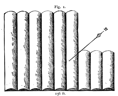
1. Wide convex beds, in parallel rows, without paths, composing independent plats. (Width of beds, 12 feet; paths, none; length, 74 to 115 feet.) Fig. 1.
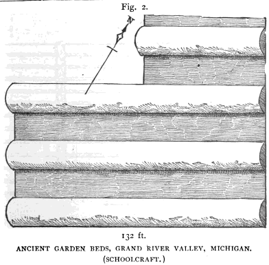
2. Wide convex beds, in parallel rows, separated by paths of same width, in independent plats (Width of bed, 12 to 16 feet; paths same; length, 74 to 132 feet.) Fig. 2.
3. Wide and parallel beds, separated by narrow paths, arranged in a series of plats longitudinal to each other (Width of beds, 14 feet; paths, 2 feet; length, 100 feet.) Fig. 3.

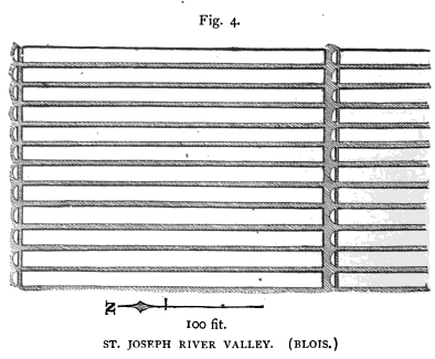
4. Long and narrow beds, separated by narrower paths and arranged in a series of longitudinal plats, each plat divided from the next by semi-circular heads. (Width of beds, 5 feet; paths, 1½ feet; length, 100 feet; height 18 inches.) Fig. 4.
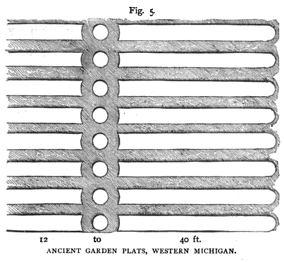
5. Parallel beds, arranged in plats similar to class 4, but divided by circular heads. (Width of beds, 6 feet; paths, 4 feet; length, 12 to 40 feet; height, 18 inches.) Fig. 5.
6. Parallel beds, of varying widths and lengths, separated by narrow paths, and arranged in plats of two or more at right angles N. and S., E. and W., to the plats adjacent. (Width of beds, 5 to 14 feet; paths, 1 to 2 feet; length, 12 to 30 feet; height, 8 inches.) Figures a, b, and c are varieties. Fig. 6.


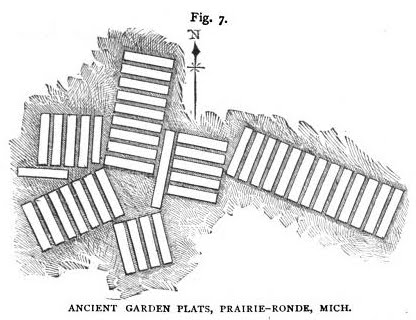
7. Parallel beds, of uniform width and length, with narrow paths, arranged in plats or blocks, and single beds, at varying angles. Width of beds, 6 feet; paths, 2 feet; length, about 30 feet; height, 10 to 12 inches.) Fig. 7.
8. Wheel-shaped plats, consisting of a circular bed, with beds of uniform shape and size radiating therefrom, all separated by narrow paths. (Width of beds, 6 to 20 feet; paths, 1 foot; length, 14 to 20 feet.) Fig. 8.

I present diagrams of each of these classes or kinds of beds. Of these only those numbered 1, 2 and 4 have ever before been delineated, to my knowledge. (See figures 1 to 8, pages 257-261.) Nos. 3 and 5 are described by Schoolcraft and Blois, while the others are figured as well – 1 and 2 by Schoolcraft and 4 by Blois. No. 3, according to the latter, consists of five plats, each 100 feet long, 20 beds in each plat. Schoolcraft does not give the exact localities, and I am unable to state whether beds of the same class have been noticed by other observers. As to their extent, his language is, “The beds are of various sizes, covering generally from 20 to 100 acres.” Some are reported to embrace even 300 acres. Plats of beds are undoubtedly here referred to.
Of the plat figured by Blois (No. 4), the writer says:
“They are found a short distance from Three Rivers, on one side of an oval prairie, surrounded by burr-oak plains. The prairie contains three hundred acres. The garden is judged to be half a mile in length by one-third in breadth, containing about one hundred acres, regularly laid out in beds running north and south, in the form of parallelograms, give feet in width and one hundred in length, and eighteen inches deep.”
The distinctive peculiarity of these beds is what Blois calls the “semi-lunar” head, at the extremity of each bed, separated from them by a path as represented.
Class 6, so far as my own inquiries warrant, represents the form and arrangement which is most common, viz.:
that of a series of parallel beds formed into blocks of two or more, alternating with other similar blocks placed at right angles to them. (See figures a, b, and c.) The prevailing width of the bed is five or six feet, and that of the paths one and a half to two feet. The length of the plats or blocks varies, the average being about twenty feet. Gardens of this kind were found by the early settlers of Schoolcraft, the burr-oak plains at Kalamazoo, Toland’s prairie, Prairie-Ronde, and elsewhere.
Mr. Henry Little says, that in 1831 they were very numerous on the plains where now stands the village of Kalamazoo; and south of the mound, eight or ten acres were entirely covered by them.
Mr. E. Laken Brown confirms this account, and says they reminded him of old New England gardens, being very regular and even, and the beds five feet by twelve or fourteen feet. In 1832 the outlines were very distinct, and the burr-oak trees on them as large as any in the vicinity. Mr. A. T. Prouty concurs as to the extent covered, but thinks the beds were six feet wide by twenty-five to forty long. On the farm of J. T. Cobb, section 7, town of Schoolcraft, the beds were quite numerous as late as 1860. There must have been 15 acres of them on his land. The “sets” would average five or six beds each. Neighbors put the number of acres covered with them in 1830, within the space of a mile, at one hundred.
Fig. 6-b, of class 6, is from a drawing by James R. Cumings, of Galesburg, of a garden in which the beds are of more than usual diversity in width and length. H. M. Shafter and Roswell Ransom, old settlers, say that three or four acres on the edge of the prairie, at this place, were covered with the beds. On the farm of the latter in the town of Comstock, of one hundred acres, there were not less than ten acres of beds, six feet by twenty-five to forty, arranged in alternate blocks, having a north-and-south and east-and-west direction.
Fig. 6-c is from a drawing by Mr. Shafter.
The series represented by Class 7 (fig. 7) were found at Prairie-Ronde. They are platted and described to me by Messrs. Cobb and Prouty. They differ from the more ordinary form of No. 6, in the arrangement of the blocks or sets of beds, which is here not at right angles, but at various and irregular angles, also in the single beds outlying. The number of beds in each block is also greater than usual.
Class 8 is established on the authority of Henry Little and A. T. Prouty, of Kalamazoo. The figure delineated is from the descriptions and dimensions given by the former. The diameter of the circular bed and the length of the radiating ones are each twenty-five to thirty feet. The latter describes two of similar design, but of smaller dimensions, the centre bed being only six feet in diameter, and the radiating ones twenty feet. All occurred at Kalamazoo, and in immediate association with the other forms of beds at that place, represented generally by Class 6.
There is reason for supposing that there may have existed another class of beds, differing altogether from any that I have represented, from expressions used by both Schoolcraft and Blois. The former speaks of “enigmatical plats of variously shaped beds;” and further, “nearly all the lines of each area or sub-area of beds are rectangular and parallel. Others admit of half circles and variously curved beds, with avenues, and are differently grouped and disposed.”
The latter says, the beds “appear in various fanciful shapes.” Some are laid off in rectilineal and curvilineal figures, either distinct or combined in a fantastic manner, in parterres and scolloped work, with alleys between, and apparently ample walks leading in different directions.”
This language is too vague to enable me to construct a diagram, nor have I any confirmation to offer from other sources. The reputation of the writers will not allow us to consider the descriptions fanciful, but it is possible to suppose they were misled by the representations of others.
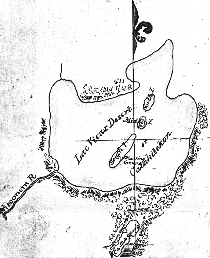
Lac Vieux Desert (‘lake of the old garden’) and Catakitekon [Gete-gitigaan (‘old gardens’)] from Thomas Jefferson Cram’s 1840 fieldbook. This is the headwaters of the Wisconsin River, and near those of the Wolf River and Ontonagon River.
~ School District of Marshfield: Digital Time Travelers
The principal crop of the Indians is maize, and this was never cultivated by them in rows, but in hills often large but always disposed in a very irregular manner. As little do these beds resemble the deserted fields of modern agriculture. On the other hand, the resemblance of many of the plats to the well-laid out garden beds of our own day is very striking; while the curvilinear forms suggest analogies quite as strong to the modern “pleasure garden.”
The nearest approach to anything resembling horticultural operations among Indian tribes, with the historic period, is noticed by Jones, who refers to a practice, among some of the southern Indians, of setting apart separate pieces of ground for each family. This author quotes from Captain Ribault’s “Discovery of Terra Florida,” published in London, 1563. “They labor and till the ground, sowing the fields with a grain called Mahis, whereof they make their meal, and in their gardens they plant beans, gourds, cucumbers, citrons, peas, and many other fruits and roots unknown to us. Their spades and mattocks are made of wood, so well and fitly as is possible.”
In the St. Joseph Valley I learned of numerous places, widely apart, where the labor and ksill of our ancient horticulturists were apparent in small gardens, laid out in different styles, and with an eye to the picturesque; as if each family had not only its separate garden patch, but had used it for the display of its own peculiar taste.
~ Bad River WPA Papers, Envelope 3, Folder 9.
~ Railroad History, Issues 54-58, pg. 26
Historians tell us of the Aztecs, that they had gardens in which were cultivated various plants, for medicinal uses, as well as for ornament. Was there something analogous to this in the Michigan Nation? Did the latter also have botanical gardens? May we accord to this unknown people a considerable advance in science, in addition to a cultivated taste, and an eye for symmetry and beauty, which is without precedent among the pre-historic people of this continent, north of Mexico?
These extensive indications of ancient culture necessarily imply a settled and populous community. We are led, therefore, to look for other evidences of the numbers and character of the people who made them. But here an extraordinary fact presents itself; such evidences are almost wanting! The testimony of nearly every one whom I have consulted – men who were among the first of the white race to break up the sod, that for ages had consecrated these old garden lands – agrees in the fact, that almost none of usual aboriginal relics were found; no pottery; no spear- and arrow-heads; no implements of stone; not even the omnipresent pipe. Tumuli, or burial mounds of the red man, are not uncommon, though not numerous, in Western Michigan, but have no recognized association with the garden race.
Upon the St. Joseph and Colorado rivers, and in the town of Prairie-Ronde, exist several small circular and rectangular embankments, resembling the lesser works of the Mound-Builders so numerous in Ohio. But no connection can be traced between these detached earthworks and the garden-beds. None of them seem to have been the bases of buildings, nor do they give indication of any religious origin or rites. There are no traces of dwellings, and the soil which has so sacredly preserved the labor of its occupants, discloses not even their bones!
At Three Rivers, and in Gilead, Branch County, are some ancient embankments, which are probably referable to this people and may pass for works of defence. That at the first named place was notably extensive. It consisted only of an earth embankment, about six feet in height, extending between two forks of a river, a mile apart. It thus enclosed a large area, and with a sufficient garrison might have withstood the siege of a large army of barbarous warriors.
It seems strange, indeed, that these garden beds, suggestive as they are, should be the only memorials of a race which has left such an evidence of civilized advancement, and was worthy of more enduring monuments! We may reasonably conclude, that they were a people of peaceable disposition, of laborious habits, and of æsthetic if not scientific tastes; that they lived in simple and patriarchal style, subsisting on the fruits of the earth, rather than of the chase. Their dwellings and their tools were of wood, and have perished. This simple record of their character and labors is all, it may be, we can ever know.
But is this all? May we not form some reasonable conjecture as to the period in which these gardeners lived?

Detail of “Chippewa Gardens” at Odanah from Narrative journal of travels from Detroit northwest through the great chain of American lakes to the sources of the Mississippi River in the year 1820, in 1820, by Henry Rowe Schoolcraft, page 105. This place is known as Gete Gititaaning (‘at the old gardens’) in Ojibwemowin.
“My children, I want you to listen to me. The proposition I am about to present will benefit all of you, and I need your cooperation. I would like to have you donate your labor to clear land for a large community garden, where every family, or any one who wishes can plant. The place I would suggest is that swampy flat, near the cemetery. It will take time to drain it and dry out but I know it will make good garden plats.“
~ Early Settlement of the Bad River Indian Reservation
A fact mentioned by Dr. Lapham furnishes a species of evidence, as to the relative antiquity of the garden beds of Wisconsin, as compared with the animal mounds. They were found overlying the latter; from which he infers, of course, a more recent origin. We may also suppose a considerable more recent age, since it is not likely that the race could have thus encroached upon the works of another, until long after these had been abandoned, and their religious or other significance forgotten.
The date of the abandonment of the beds may be approximately fixed, by the age of the trees found growing upon them. One of these mentioned by Schoolcraft, cut down in 1837, had 335 cortical layers. This carries the period back as far as 1502, or some years prior to the discovery of this country by the French. How long these labors were abandoned before this tree commenced its growth may not be susceptible of proof. Early French explorers do not appear to have been interested in the question, and it does not seem to me necessary to go further back than the three centuries during which that tree flourished, for a period quite long enough to have crumbled into indistinguishable dust every trace of wooden dwellings and implements, as well as of the bodies of their fabricators, if the latter received only simple earth burial.
(Anishinaabe Migration Story):
“In the Third Fire the Anishinabe will find the path to their chosen ground, a land in the west to which they must move their families. This will be the land where food grows upon the waters.”
~ The Mishomis Book – The Voice of the Ojibway by Edward Benton-Banai, Chapter 13 – The Seven Fires.
At the time of the arrival of the French the country was in possession of Algonquin tribes, who emigrated from the St. Lawrence about the middle of the 16th century. They were ignorant of the authors of these works, and were not more advanced in the arts of culture than the other known tribes.
It is probable that the few defensive works I have mentioned were erected by this settled and peaceful race of gardeners, as places of temporary refuge for the women and children, against the raids of the warlike tribes living eastward of them. The larger one may have served for the general defence in a time of sudden and great emergency. It is probable that on some such occasion they were surprised by their savage and relentless foes, and were overwhelmed, scattered or exterminated.
Most of the facts I have been able to present are gathered, in large part, from the memories – of course not always exact or reliable – of early settlers, and after modern culture had for many years obliterated the old.
It is perhaps useless to regret that these most interesting and unique relics of a lost people have so completely perished, through the greed of the dominant race; or that they could not have received, while they yet remained, the more exact and scientific scrutiny which is now being applied to the antiquities of our land. Much that might then have been cleared up, must now remain forever involved in mystery, or be left to conjecture.
– – – – – – – – – –
In September, 1885, the writer visited the region of the ancient garden beds, in hopes of being so fortunate as to find some remaining. He did discover, near Schoolcraft, on a plat of land which had been recently cleared of its timber, a few traces of beds belonging to a set, most of which had been broken up by the plough.
Four or five beds could be distinctly traced, for the distance of some ten to fifteen feet. The remainder of their lengths, said to be some twenty to thirty feet, had been obliterated by cultivation. Each bed had a width of about ten feet from centre to centre of the intervening paths. The latter had apparently a width of two or three feet, but it was impossible to define the exact outlines.
After much inquiry I could learn of no other place in or near Prairie-Ronde, or the plains of St. Joseph and Kalamazoo Counties, where any traces of the old garden beds remained.
Mr. Cobb informed me that about 1859 he endeavored to preserve portions of a set of these beds, which were well covered by touch, protective prairie sod. But when the white grub took possession of the turf thereabouts his ancient garden reserve did not escape. In a year or two the hogs, in their search for the grub, had so rooted and marred the outlines that he ploughed the beds up.
I found many old residents who well remembered the garden plats as they appeared a half century ago, and all concurred in the admiration excited by their peculiar character and the perfection of their preservation. Mr. Cobb says, he often took his friend to see his “ancient garden,” counted the beds, and speculated upon their object. The set of beds, which is shown only partially in his sketch (Fig. 7), contained thirteen beds, and was the largest of the sets. The others averaged five or six beds each.
All concurred, too, as to the great extent of land, amounting to several hundred acres, covered, wholly or partially, by the beds, chiefly upon the northern edge of the prairie. That all visible evidence of their existence should have so completely disappeared is not surprising to any one who notes their situation, upon the richest portions of the mixed prairies and plains. The lands most esteemed by their garden race were those which first attracted the modern farmer. These lands still constitute fields as beautiful as the eye can anywhere rest upon, and in a region second in loveliness to no other part of our country. The wants of the early settler almost preclude any care for the preservation of what was regarded as mere curiosities. Even when spared from the plough, and left to the care of nature, the absence of the annual fires, which had prevented the growth of timber; the roots of trees upheaving the beds; the decay of fallen timber; the hummocks caused by upturned roots; the destruction of the turf by the forest growth, and by cattle and hogs, all tend to deface the beds, and leave them to be reduced to the general level by the elements. Under these circumstances, a few years even would suffice to obliterate outlines which had remained almost unaltered for centuries.
Lake Superior in 1840
September 1, 2016
By Amorin Mello
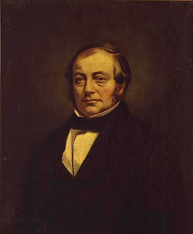
“Soon after removing to Detroit, Bela Hubbard became acquainted with Douglas[s] Houghton, then State Geologist of Michigan, and in 1837, was appointed Assistant Geologist on the State Geological Survey, a position which he held until 1841. He accompanied Douglass Houghton on an important expedition to the southern shore of Lake Superior, in 1840, an account of which is given in his ‘Memorials of half a century.’ It is this book more than anything else that will preserve the memory of its author. It is his most fitting and most enduring monument and entitles the name of Bela Hubbard to a place on the short list of American authors who may be justly termed ‘nature writers.'”
Quote from Report of the Michigan Academy of Science, Volume 4,
by Michigan Academy of Science Council, 1904, page 163.
This is a reproduction of “Lake Superior in 1840” and illustrations from Memorials of a Half-Century, by Bela Hubbard, 1887, pages 21-62.
LAKE SUPERIOR IN 1840.*
* Read before the Detroit Pioneer Society, Jan., 1874.
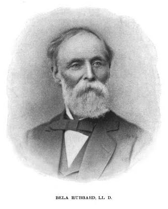
Portrait and biographic sketch of Bela Hubbard are available in Report of the Michigan Academy of Science, Volume 4, by Michigan Academy of Science Council, 1904, pages 163-165. See the Bela Hubbard Papers: 1837-1893 for more information.
Among the pleasantest of all my reminiscences of travel is that of the exploration, in connection with the geological survey of Michigan, of the coasts of our upper peninsula, in 1840.

Portrait and biographic sketch of Douglass Houghton are available in Report of the Michigan Academy of Science, Volume 4, by Michigan Academy of Science Council, 1904, pages 160-162. See the Douglass Houghton Papers: 1829-1845 for more information.
The party for this expedition was composed of the State geologist, Dr. Douglass Houghton; his two assistants, C. C. Douglass and myself; Fredk. Hubbard, in charge of instrumental observations; and, for a part of the way, H. Thielson, a civil engineer, and Charles W. Penny, a young merchant of Detroit, supernumeraries.
We left Detroit in the steamer “Illinois,” arriving at Mackinac, May 23. Here two boat crews were made up, consisting of six Canadians. These belonged to that class so famous in the palmy days of the fur trade and the French régime, now extinct, and known to history as “coureurs de bois.” They were of mixed blood, in some, the French, in others, the Indian, predominating. Bred to the business, they would row without fatigue from daybreak until dark,—twelve or fourteen hours,—unlade the boats, pitch the tents for the bourgeois, pile up the baggage, prepare the evening meal, and then creep under their blankets in the open air and enjoy the sound sleep that labor bestows.
The principal dependence of these voyageurs for food—we had no leisure for hunting and little for fishing— was upon a soup of beans, with a most liberal supply of water, into which a piece of pork was dropped. A cake of hard-bread was allowed to each.
The boats for the passage of the Sault were each about twenty feet long by four broad, lightly constructed of pine and cedar, with sharp bows, and were drawn out of the water at night. At the Sault, to which provisions had been forwarded, one of these boats was exchanged for a “Mackinac barge,” sufficiently large to carry two months’ provisions and all our baggage.
A voyage to and upon our great lake at the time of my story was by no means the easy journey it is now. North of Mackinac, no steamers and no regular line of sail-vessels traversed the waters. The ship-canal around the waters of the Sault had not then been projected. Furs and fish constituted the only commerce, and the latter found too few customers to make the trade profitable. The American Fur Company had its headquarters at Sault Ste. Marie, where was a village of some twenty or thirty houses, mostly of logs, and the United States maintained a garrison. On the opposite shore was a small English settlement, consisting of a few white-washed cabins and Episcopal and Baptist mission establishments. Here also the Hudson’s Bay Company had a post.
At L’Anse had been established for many years a factory of the American Fur Company, the only buildings being a log house, storehouse, and barn, and near by a Baptist mission, consisting of a dozen neat huts of logs and bark. Near the extreme west end of the lake this company had another factory or trading-post, at La Pointe.
These were the only white settlements on the south shore of this great lake. At two or three points, transient fishing-camps might be met with. Else, all this region was wild and solitary almost as when, a century earlier, it was traversed by the canoe of the Jesuit missionary or echoed to the rude songs of the wild employees of the fur traders. In a large part of the country, on the southern border, within the territory of the United States, the Indian title had not been extinguished. But the settlements of the aboriginal race were rare; probably the whole region did not number 1000 souls.
Apart from the scientific animus of the expedition, our party, in the ardor of youth, could not but look forward to the new and strange scenes which awaited us with somewhat of the enthusiasm that inspired the first explorers of this region of vast forests and inland seas. We were to voyage almost in the same mode as those travellers, to witness scenes as yet little changed, and partaking of the same character of solitude and mystery.
Though I wander from my narrative, I must linger a moment over the impression produced by the romantic island which was our starting-point, Michilimackinac.
Connected with the story of the early wanderings of the French, their perilous missions in the far wilderness, the fur trade, with its fort, its agents, its coureurs de bois and numerous employees, its bustle, show, and dissipation, its traffic and its enormous profits, and with the numerous native tribes which here rendezvoused,—no place in the North-west possesses greater historic and traditionary interest. The town retained, as it still does, much of its old-time character. The crescent bay in front was still a lounging-place for the American Ishmaelite, whose huts often covered the beach; and this was the last place on the frontier where the Mackinac barge might manned and equipped, as a century ago, by a motley crew of half-breed voyageurs.
The natural beauties and wildness of the island, its situation, enthroned at the apex of the peninsula of Michigan and embracing magnificent views of water and island, its lake breezes and pure cold air, and the excellence of its white-fish and trout, have long made it one of the most attractive of watering-places. The proposal to conserve it as a national park is worthy of its character, and it is to be hoped that thus its natural beauties, and what remains of its woods, will be preserved forever to the nation.
On the morning of May 26 we took our departure from Mackinac, with a moderate breeze and a clear sky,—a thing to be noted where fogs are so frequent,—and coasting by St. Martin’s Island, entered les Cheneaux.
The river, or more properly Strait of Ste. Marie, is a series of channels, winding amid innumerable islands. Some of these, as St. Joseph and Drummond, cover many square miles, but the greater number are much smaller, and often occupy only a few acres. They line the whole northern coast of Lake Huron, and are occasioned by the junction between the silurian lime rocks and the azoic or primary rocks of Canada.
These islands are but little elevated above the water, and are wooded to the edge with cedar, fir and birch. The evergreen trees are completely shrouded in a tapestry of parasitic moss. This is a true lichen, and is not allied to the great Southern epiphyte which it so strongly resembles. It hangs in long festoons, giving the woods a fantastic and gloomy appearance, but the effect is very beautiful. What are called “les Cheneaux” are passages among islands of this description. They are seldom wide enough to admit any but the smallest craft, and so intricate as to form a perfect labyrinth, where any but the practised mariner might wander long, “in endless mazes lost.”
To the north and east of St. Joseph Island the Ste. Marie parts the two systems of rocks, and an instant change takes place in the character of the scenery. Instead of low, timbered shores, the islands rise in abrupt cones, rounded and water-worn, to the height of twenty to one hundred feet, presenting bare knobs of hornblende and quartz. The surfaces are worn smooth, by the action of glaciers, and are frequently covered with a thick carpet of lichens. Among these is, in profusion, the beautiful reindeer moss. A few miles to the right, in Canada, hills of granite rise to a height of 500 to 1000 feet, and form a background to the view.
To the geologist these low hills and rounded knobs have an absorbing interest. Agassiz tells us that America has been falsely denominated the new world; that “hers was the first dry land lifted out of the waters; hers the first shore washed by the ocean that enveloped all the earth beside.” The antiquary finds in this portion of America a very respectable antiquity. To its known civil history he adds evidence of the existence of a race of men familiar with this region ages before its discovery by the French, who were by no means despicable cultivators of the arts, and he infers a human history—could he but gather the full record—possibly as ancient as the pyramids. But science points a period infinitely more remote. We had reached and stood upon what was the skeleton of our earth, when but a crust above the seething fires beneath, not only ages before man had a being upon its surface, but probably ages before what we call the “Old World” had been raised by the forces of nature above the universal ocean. Here was antiquity unmeasured by any human standard. Time itself was young then. This backbone of the earliest continent still stretches unbroken, from the Atlantic to the western plains. During the unnumbered years in which the surface of the earth has been changed by successive upheavals and depressions it has stood unmoved.
Around the base of these low granite and metamorphic hills, in the bed of the river, lies a sandstone rock, which we shall find rising into cliffs along the coast of the lake above. It is the lowest of the paleozoic series, the first rock which brings to our eyes evidence of life upon this continent, and, if geologists speak truth, the first which bears witness to the dawn of life upon our earth. Of the earliest forms of organic life two only have with certainty been found in this rock, the lingula and the trilobite. And these, in the perfection and adaptation of their structure, equal the most perfect beings of their kind which exist at the present day. Thus the first record of the earliest life, upon the most ancient sea beach which the earth affords, is in apparent condemnation of the development hypothesis of Darwin. Are they then evidence of sudden and independent creation, or must we believe that these forms had their origin in some yet more remote and obscure past, and that we behold in these silurian rocks only their perfect development?
Following the northerly channel, the Ste. Marie soon expands into a broad and lovely sheet of water, twelve miles long, called Lake St. George. We have escaped from the labyrinth of rocky isles, the southern shores are again densely wooded, while the azoic rocks are seen on the Canada side, stretching off to the north-west, and terminating in a series of mountainous knobs,—the vertebræ of the world before the Flood. To this lake the Narrows succeed, and here for the first time the Ste. Marie assumes the appearance of a river, being contracted to less than 1000 feet, with a current and occasional rapids.
We passed frequent memorials of the Indian inhabitants. It is not to be wondered at that this region abounds with them, since with an eye to natural beauty this poetical race selects the loveliest spots for the resting-places, both of the living and the dead. The graves were close cabins of logs, thatched with bark, and the places selected are among the most beautiful and elevated sites, as if the souls of the departed braves could hear the echoing paddle and watch the approach of the distant canoe. The burial-place of the chief is designated by a picketed enclosure, and here it is customary for the voyaging Indian to stop, kindle his camp-fire at the head of the grave, and, on departing, to leave within the enclosure a small portion of the provisions he has cooked, for the use of the occupant. A flat cedar stake at the head exhibits in red paint the figure of some bird or brute,—the family totem of the deceased. Often is seen a small cross, erected as an emblem of his faith in Holy Catholic Church, while close by, in strange contrast, is that evidence of his unalterable attachment to the creed of his fathers,—the basket of provisions that is to support his journeying to the land of spirits.
The camping-ground of the voyageur has been that of the Indian from time immemorial. The wigwam poles are recognized from a distance, in some open glade along the shore, left standing after the vagabond inmates have departed. And there is often to be found an old canoe, a camp-kettle, a cradle swinging from the poles, and invariably a litter of picked bones and dirty rags, completely covering the spot, with the burnt brands and ashes of the cabin fire in the midst. Sometimes we meet a rude altar of stones, on which are laid bits of tobacco and other petty offerings to the Manitou. Sometimes the scene is varied by the cabin of a Canadian Frenchman, who, unable to resist the charm of savage life, is bringing up his family of half-breed children in a condition little akin to civilization.
Early on the morning of May 30 we reached the Sault, and proceeded to encamp at the head of the rapids. This required a portage of several rods. The remainder of the day was spent at the village, in witnessing the novel mode of fishing, and other sights pertaining to this remote frontier post.

Page 29: “Sault Ste. Marie, from the Canada shore.”
Preparations for our expedition being completed, on the first of June we took our departure from the head of the rapids. Here lay at anchor a beautiful light brig belonging to the American Fur Company, and which bore the name of its founder, John Jacob Astor. Close by its side was a schooner, which had been built by the Ohio Fishing and Mining Company, at Cleveland, and had just made the portage around the rapids. Another vessel was preparing for a similar transportation. With three such crafts floating on its bosom, our great lake seemed to have already lost something of its old-time character, when, a wide waste of waters, it was traversed only by the canoe of the Indian and voyageur. Its importance as a great commercial highway had thus begun to be foreshadowed, but, in fact, its waters still laved a savage wilderness.*
* The immense commerce since built up will appear from the statement, that in 1886 the number of vessels which passed through the Ste. Mary’s Falls Canal was 6203, carrying 3,701,000 tons and over 50,000 passengers.
Some natural phenomena pertaining to a high northern latitude had begun to exhibit what were marvels to our unaccustomed eyes. One of these was the lengthened twilight, the sun continuing to irradiate the horizon with a bright flash, until nearly midnight. In fact, it was quite possible to tell the hour of the night at any time, by the light which indicated the sun’s position. The Auroras, too, were surpassingly brilliant; often the electric rays streamed up from every point of the horizon, meeting at the zenith and waving like flame. I note these simple and common phenomena because they were novel to us, and it is only those who travel and encamp in the open air who enjoy to the full such scenes of beauty and wonder.
A summer temperature had now set in, and we witnessed another characteristic of this high latitude,—the sudden advance of the season. During the three days of our stay at this place, vegetation, which a week before had hardly commenced, sprung into active life. Trees then bare were now in full leaf. This phenomenon, though common to our side of the Atlantic, we had nowhere else seen so conspicuously displayed.
Time will not permit a narrative of our journey, a two-months’ coasting voyage along the whole southern side of Lake Superior. Nor can I speak, except briefly, of the beauties of the scenery, most of which is now so well known; of Gros Cap and Point Iroquois, those rock-built pillars of Hercules that guard the entrance, and
“like giants stand, To sentinel enchanted land;”
of White-fish Point and its surroundings; of the grand, wild and varied rocky coast; of the many beautiful streams, flashing with cascades, and filled with the speckled trout; or of our scientific researches and observations. I will venture only to relate an occasional incident, and to delineate some features of the coast scenery which seem to me to have been to little noticed or too imperfectly described by others.
Westward from White-fish Point stretch for many miles broad beaches of sand and gravel, backed by hills clothed with Norway-pines, spruce, hemlock, cedar, and birch. These beaches form extensive fishing-grounds, of which parties had already availed themselves. Every one knows the superiority of Lake Superior white-fish, in size and flavor, over those of the lower waters. Yet in relating the following experience I am aware of the risk which I run of being set down as the retailer of a “fish story.”
As we were rowing along the beach, some object was descried at a distance, making out of the water. All, at once, gave vigorous chase. On our near approach, the animal, which proved to be an otter, dropped upon the sand a fish which he had just hauled out, and retreated into the lake. This fish, which was scarcely dead, was of a size so extraordinary that it might truly be called—the fish, not the story—a whopper! It measured two and a half feet in length, and one foot five inches in circumference. We had no accurate means of weighing, but its weight was fairly estimated at fifteen pounds! The flesh was delicious in proportion, and made our whole party several capital meals.
These beaches terminate at a deep harbor called the Grand Marais. Hitherto the hills of dunes of sand have been of no great elevation. But now occurs a phenomenon which, though it seems not to have been classed among the wonders of this region, nor described in any books of travel, so far as I am aware, may well be called extraordinary, and worthy a place among the scenic wonders of America. It is a miniature Sahara, several miles in extent, and in many of its peculiar features resembling those lifeless, sandy deserts which are so distinguishing phenomena in some parts of the world. It is known to the French voyageurs as “Le Grand Sable.”

Page 33: “Grandes Sables.”
Steep cliffs are first observed rising from the water with a very uniform face, of about 200 feet in height, beyond which are visible barren dunes, rising still higher in the distance. On our approach the whole appeared like lofty hills enveloped in fog. This proved to be nothing less than clouds of sand, which the winds were constantly sweeping towards the lake, and which formed a mist so dense as to conceal completely the real character of the coast.
On ascending these steep and wasting cliffs, a scene opens to view which has no parallel except in the great deserts. For an extent of many miles nothing is visible but a waste of sand; not under the form of a monotonous plain, but rising into lofty cones, sweeping in graceful curves, hurled into hollows and spread into long-extended valleys. A few grass roots and small shrubs in some places find a feeble subsistence, and are the only vegetation. But thrusting through the sand are several tops of half-buried pines, barkless, and worn dry and craggy by the drifting soil, while below the surface their bodies appear to be in perfect preservation. To our imagination they seem the time-worn columns of an antique temple, whose main structure has long ago tumbled into dust, or been buried, like the ruins of Egypt, beneath the drift of many centuries.
The surface sand is mostly packed quite hard, and may be trod as a solid floor. This, in many places, is strewed thickly with pebbles; the deep hollows present vast beds of them. Among these are a great variety of precious stones common to the rocks of the country; agates, chalcedony, jasper, quartz of every shade of color and transparency, with hornstone, trap, and other minerals. All are worn smooth, and often beautifully polished by the sharp, drifting sands, and many rich specimens were obtained. We were reminded of the valley of diamonds in the Arabian tales, which it was the fortune of Sinbad to discover, in a scarcely less singular depository.
In the rear of this desert, about two miles from the coast, timber is again met with. Here, just at the edge of the wood, a small and beautiful lake lies embosomed; on the one side, a rich tract of maple forest; on the other, barren and shifting sand. It broke on our view, from amidst the realm of desolation, as did the unexpected fountain to which Saladin led the weary cavalier, Sir Kenneth, over the sandy plains of Palestine, as told in the magic pages of Scott. We named it, not inaptly, I think, “the diamond of the desert.” Around this sheet of water we found snow, on the tenth of June, in large quantities, buried beneath a few inches of sand.
From the diamond lake issues a small stream, which, after making its way through the sand, reaches the clay that constitutes the base of these dunes, and tumbles a perfect cascade into the greater lake. This rivulet separates the dense maple forest which lies on the east from cliffs of driven sand, which rise abruptly to a height that far overlooks the woodland, and are the commencement of the grand and leafless sables.
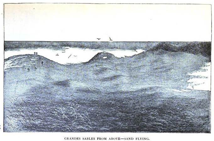
Page 35: “Grandes Sables from above – sand flying.”
The view on ascending these is most entrancing. On the one side stretches beneath, and far away, the verdant forest; while, by a transition as sudden as it is opposite in character, on the other side every feature of the landscape seems as if buried beneath hills of snow. The desert surface might be likened to that of an angry ocean, only that the undulations are far more vast, and the wave crests more lofty than the billows of the sea in its wildest commotion. Looking upward from one of these immense basins, where only the sandwave meets the sky, the beholder is impressed with a sublimity of a novel kind, unmixed with the terror which attends a storm upon the Alps or on the ocean. The scene, wild and unique, may well claim this brief praise, though hitherto unsung, and lacking the charm of historical association,—“the consecration and the poet’s dream.”
Twelve miles beyond this singular region the beaches terminate, and the sand-rock makes its appearance on the coast, in a range of abrupt cliffs. These are “The Pictured Rocks.” They have been often described, but no description that I have seen conveys to my mind a satisfactory impression of their bold, wild, and curious features. In attempting to convey some dear comprehension of them, I can only hope to impart a faithful, though it be a feeble conception of the peculiar features of this marvel of the Northern Lakes.
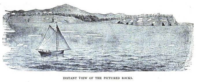
Page 37: “Distant view of the Pictured Rocks.”
These cliffs are composed of the same gray-and-red sand-rock which I have alluded to as the lowest of the paleozoic or silurian rocks. It appears in many places on the coast, and probably forms a large part of the bed of the lake. The cliffs here rise into a mural precipice, springing perpendicularly from the deep waters to the height of from 80 to 250 feet; and for the distance of fifteen miles, except in one or two places, are destitute of a beach upon which even a canoe may be landed. So dangerous is the coast that vessels all give it a wide berth, passing at too great distance for accurate view. A small boat that lingers runs imminent risks, from the liability of this lake to sudden gales, and the traverse is attempted only during a perfect calm. The sandrock lies in thick strata of varying degrees of hardness, from a coarse crag of the hardest cemented pebbles to a friable rock of aggregated sand. The predominant color is gray, sometimes light, often dark and rusty, and stained by oxides of iron and copper, with which the materials are charged. Bearing in mind these characteristics, the variety of aspects and the strange forms that these cliffs assume will find a ready explanation.
The great diversity of hues that give so beautiful and variegated an appearance to large portions of the surface, and from which the cliffs derive their name, are owing to the metallic oxides which have filtered through the porous stone in watery solutions and left their stains upon the surface. Beautiful as is the effect, it is due to candor to say that to my eyes there appeared but very imperfect representations of those various forms in the vegetable and animal kingdoms which figure in the highly-colored and fanciful descriptions in travellers’ tales. Too extravagant an idea could scarcely be conveyed of the exceeding brilliancy of the coloring; but in regard to what artists style the “laying on,” the picture presented a much closer resemblance to a house-painter’s bucket, upon the outside of which paints of all colors have trickled down in tapering streams. They represent not so much the picture which Nature has painted, as the palette upon which she has cleaned her pencils. Every hue of the rainbow, besides black and white, and in every possible circumstance of shade and alternation, are drawn in long lines, covering thousands of feet of surface.
Near the western extremity of the range, these colors assume a surpassing brilliancy, with a metallic lustre. Streaming over a gracefully curved surface, having an area of several thousand yards, they mimic, on a gigantic scale, the stripes on our national flag, as it waves in the breeze; or, passing down a fractured ledge, are contorted into long zigzag lines.
Upon close examination, these colors are found to proceed from slimy exudations, and to retain their brilliance only while fresh. When the face of the cliff has become dry, they possess a more faint and often mottled appearance. Then may sometimes be found depicted, upon a background of white, yellow or dun, as if rudely dabbed in by the artist, those vague similitudes, in which the imagination may realize verdant landscapes or fierce battle scenes; perhaps, if sufficiently vivid, a full set of Raphael’s Cartoons. As a whole, the general effect of the coloring is so striking, that the appellation conferred upon these cliffs is well deserved. Thus strangely drawn, upon as strange a canvas, they add, at least, wonderful beauty and effect to the greater wonders which Nature has here displayed.
But color is far from being the most notable feature of the Pictured Rocks. The disintegrating material of which the rock is composed renders it very susceptible to the effects of the elements. These cliffs present indubitable evidence that the lake once washed them at a height many feet above its present level. And as the strata are of differing degrees of hardness, they have been worn by the waves into a variety of forms. Huge cavernous fissures penetrate the massive wall, often to the distance of several hundred feet, piercing through its great projecting buttresses, and leaving the solid mountain supported by bare pillars. These, in turn, are worn by the eddying waters into cylindrical columns, connected by arches that sometimes spring with great regularity to a vast height.

Page 41: “La Portaille.”
An immense angular projection of the cliff, known to voyageurs as “La Portaille,” exhibits on its three sides arches of this construction, one of which springs to a height of about 150 feet. The openings form passages into a great cavern, or more properly a vestibule, the roof of which is beyond the reach of our longest oars, and which conducts through the entire projecting mass,—a distance of not less than 500 feet. Entering with our boat into this natural rock-built hall, its yawning caverns and overhanging walls strike a sudden awe into the soul. Echo gives back the voice in loud reverberations, and the discharge of a musket produces a roar like a clap of thunder. “Even the slight motion of the waves,” writes Governor Cass, “which in the most profound calm agitates these internal seas, swept through the deep caverns with a noise of distant thunder, and died upon the ear, as it rolled forward in the dark recesses inaccessible to human observation; no sound more melancholy or more awful ever vibrated upon human nerves. Resting in a frail canoe, upon the limpid waters, we seemed almost suspended in air, so pellucid is the element upon which we floated. In gazing upon the towering battlements which impended over us, and from which the smallest fragment would have destroyed us, we felt, and felt intensely, our own insignificance. No splendid cathedral, no temple built with human hands, no pomp of worship, could ever impress the spectator with such deep humility, and so strong a conviction of the immense distance between him and the Almighty Architect.”* Enthusiastic language! and yet it cannot be deemed exaggerated.
* Discourse before Detroit Historical Society.
The number and perfection of the wave-created pillars meeting the eye at every turn,— and which seem formed to support the immense weight above,—the various forms of the arches and of the overhanging rock, bear a close resemblance to the orders of human architecture. The rotundity of the columns is, in general, well preserved, and their tops swell into capitals. The supported mass, which is seldom less than 100 feet in thickness, often assumes characteristic forms, corresponding to the mock design. In one instance, for nearly half a mile, it resembles a vast entablature, of which the cornice,—jutting at least 20 feet, with a curve whose grace is not excelled by the best sculpture,—the pictured frieze, the mouldings, metopes, medallions, and other of those forms which pertain to Grecian architecture, are struck out, with a master, but giant hand, in magnificent relief, and with a perfection truly admirable. A portion of the structure had fallen, and lay at the base in heaps of ruins. But even the imperfections appear as if due to the gradual process of decay. It requires little stretch of the imagination to conceive the whole fabric to be an enormous edifice, the grandest of man’s construction, of which the main body has by some convulsion been suck and engulfed in the waters. We thought of these monuments of ancient art which the volcanic rain of Vesuvius has overwhelmed; but such a temple as this would have enclosed half of Pompeii!!

Page 43: “The gothic rock.”
The mind naturally inquires, Are the beautiful forms of ancient architecture the result of long and laborious study, or was some marvel like this exhibited in that distant era, from which cunning sculptors borrowed those designs that immortalized the Parthenon? And if—as the learned have supposed—the marble structures of that age received the addition of a coat of glowing colors,—of which time has left some traces—we here view the prototype, not only of the graceful forms upon which they labored so successfully, but of the overlay of colorings, in the glory of their original freshness!
These are but single features in the scenic display. The line of cliffs is not uniformly regular, but curves gradually to the south-west, and presents many angles and projecting points. Passing on to harder portions of the rock, the voyageur may encounter at the next angle a vertical and unbroken wall, rearing its solid front from the bed of the lake to the height of from 200 to 300 feet above the surface. The sharpness of the angular projection equals that created by the square and plummet; while the immense thickness of the strata causes the wall to appear as laid in immense blocks, a hundred feet in length. No such blocks were built into their mausolea by the proudest of the Pharaohs.
New changes present themselves as the traveller proceeds. Suddenly he is before the walls of an impregnable fortress, complete with glacis, bastion, and towers. The western cape of Miner’s River exhibits a curious display of this kind. It resembles the dilapidated tower of some timeworn castle. The base rests upon a series of short columns, connected by groined arches, through many of which a boat may pass with ease. There are eight or ten of these pillars; several have large entrances above, and the tower rears its broken battlements to the height of 120 feet.

Page 45: “La Chapelle, from the Lake.”
Among the characteristic features, none is more extra-ordinary than one to which the French voyageurs have appropriately given the name of “La Chapelle.” This rock was originally part of the solid cliff, of which the greater portion has been swept away, causing a valley about half a mile in breadth, through which a considerable stream enters the lake, falling over the rocks in a sheet of foam. Close by, reared upon the rocky platform, about twenty feet above the lake, and conspicuous from its isolation, stands the chapel. It consists of a tabular mass of sandstone, raised upon five columns, whose capitals swell into a uniform arch and support the ceiling or dome of the edifice. Its whole height is 56 feet. The pillars are somewhat irregular in form and position; including their bases, they are about 25 feet in height, and from 4 to 6 feet diameter in the swell. Regular proportion are not altogether preserved, for in most of them the central portion has the smallest diameter, like an hour-glass. Two uphold the front, and from these the arch springs to the height of 30 feet, allowing to the roof a thickness of five or six feet. The span of this arch is 32 feet, as viewed from the water, in which direction the spectator looks completely through the temple into the woodland beyond. The strength of the roof thus upheld must be considerable, since it is clothed with timber, and from the very centre shoots, spire-like, a lofty pine. The cliff on which the edifice stands forms a proportionate pedestal, ascending from the water in steps, which may be easily mounted.
This solemn natural temple might contain a congregation of several hundred persons. Nor are the usual accommodations for the preacher wanting. A column, the upper half of which has been broken, projects from a recess in the walls, and is worn into a curve behind, like the half of a letter S, creating a stand which would serve the purpose as admirably as it strikingly resembles the old-fashioned pulpit, the base of the column affording convenient steps.
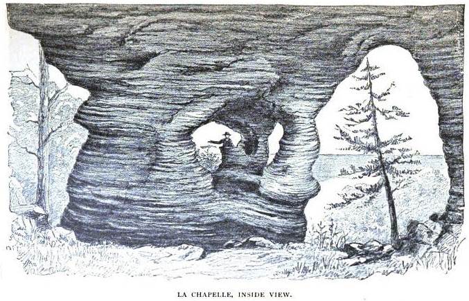
Page 47: “La Chapelle, inside view.”
Upon the cliff, just without, a column stands detached, and worn into the form of an urn, no bad representation of the baptismal font.
At what epoch of the world, or for what class of worshippers, this almost perfect temple was created, we might ask in vain of geologist or theologian. Certainly it is well designed to raise in the beholders thoughts of adoration for its all-skillful Architect, while they assign to it a chief place among the wonders of his workmanship.
An urn-shaped mass, similar to the one here observed, of great regularity and beauty of form, and not less than 50 feet in height, may ben seen at another point of the coast. Several rills of water leap from the very top of these precipitous cliffs, and add much to the charm of the view. Indeed, taken in connection with the wide-sweeping lake, the distant mountain ranges, and the woodland, crowning the cliff, the scene presented is of the most picturesque and wildest character.
“Where’er we gaze, around, above, below, What rainbow tints, what magic charms are found! Rock, river, forest, mountain, all abound, And bluest skies that harmonize the whole; Beneath, the distant torrent’s rushing sound Tells where the volumed cataract doth roll, Between those hanging rocks, that shock yet please the soul.”
Against these huge ramparts in the hour of the storm the billows of this impetuous lake dash with terrific fury, rumbling beneath the open arches, until, from the hollow caverns within, the sounds return like distant echoes, and at times their spray is thrown to the very summits of the cliff. Woe betide the bark that is overtaken by the tempest before these hopeless barriers!
But when the winds are down, lulling the lake to gentlest murmurs, the cautious boatman piles along the lone rampart, and with beating heart ventures to explore its awe-inspiring recesses, those.
“Worn and wild receptacles, Worked by the storms, yet work’d as it were planned, In hollow halls, with sparry roof and cells.”
From this sketch some correct idea may perhaps be gathered of a few of those strange forms which Nature, in her sportive hours, has here carved out of the solid fabric of the globe, as if in mockery of the efforts of man, gigantic monuments of that immeasurable Power who formed the wonders of the universe.
Thirty miles west form the Pictured Rocks, at Chocolate and Carp rivers, we first met, in their approach to the shore, the azoic or primary rocks, which from here onward constitute so interesting and important a feature in the geology of the country. Of their scientific or their economical character it is not my purpose to speak, further than to say that to them belong the iron beds, which are such a mine of wealth to our State. Here, a few years after our visit, sprang into being the busy and thriving city of Marquette. But at the time of which I speak, all was a solitude.
From hence to Keweenaw Bay ranges of granite knobs rise into considerable hills, and around them lie a series of quartzites, slates, and metamorphosed sandstones. The granites are pierced by dykes of trap, which in some cases form straight, narrow, and often lofty walls, in others have overflowed in irregular masses. Here Pluto, not Neptune, has been the controlling spirit, and has left the witness of his rule upon the face of the country. Ascending the knobs of granite and quartz, the change is most striking. To the east the eye embraces a tract lying in immense broad steppes of the sandstone, extending beyond the Pictured Rocks; while to the west are seen only rolling hills and knobs, terminating in the Huron Mountains.
I can add nothing to what is so well known of the mineral riches of this part of the country. But there is in its building-stones a wealth that is hardly yet begun to be realized. No more beautiful and serviceable material than the easily-worked and variously-tinted sandstones is found in the West; and her granites, already broken by natural forces into convenient block, and as yet untried, will command a market in the time coming, when the solid and durable shall be regarded a chief requisites to good architecture.
Following our westerly direction to Point Keweenaw, we find the dominion of Pluto established on a most magnificent scale. Not only is his energy displayed in the stern and rock-bound coast, but in the lofty ranges of trap, which rise into rugged hills of from 400 to 900 feet above the lake. Within these are secreted, but scarcely concealed, those wonderful veins of native copper, here quarried rather than mined, in masses such as the world has nowhere else produced.
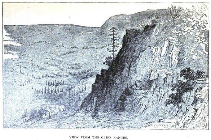
Page 51: “View from the cliff ranges.”
But of all this wealth nothing was then known, except that traces of copper were visible at a few places along the coast, and that a large mass of the native metal lay in the bed of Ontonagon River, long revered by the Indians as a Manitou, and mentioned in the relations of the early French historians.
I will but add, as the result of this season’s explorations, that the report of the State geologist, published the ensuing winter, unravelled the whole subject of the mode of occurrence of the copper and its associated minerals, in the most complete and scientific manner. It first made known the immense value which Michigan possessed in its hitherto despised Upper Peninsula; and its immediate effect was to arouse an interest in this then wild and uninhabited Indian territory, which has led to the opening up of its mines, and its present teeming prosperity.
On the third of July we encamped at Copper Harbor, and spent several days in exploration of the surrounding country, and in blasting for ores. Several blasts were got ready for the great national jubilee, which we commemorated in the noisy manner usual with Americans, by a grand discharge from the rocks. We succeeded in producing a tremendous report, and the echo, resounding from the placid water as from a sounding-board, pealed forth in corresponding reverberations for several minutes. Later in the day we retired to our camp and partook of an equally grand dinner. It consisted of pigeons, fried and stewed, corn and bean soup, short-cake and hard-tack, pork, and—last but not least—a can of fine oysters, which had been brought along for the occasion. Truly a sumptuous repast for a party of wilderness vagrants, even on a Fourth of July anniversary!
But time warns me to hasten my journey. I will therefore proceed at once to the Ontonagon, where an adventure befel, which it becomes a true knight-errant to relate. It was our purpose to pass up this river to the large mass of copper already alluded to. As we landed at the mouth there were noticed, on the opposite side of the river, several Indian lodges. As soon as we had dined, a few of the occupants crossed over in canoes, shook hands with us, giving the usual greeting of “Bo jou,” and received a small gift of tobacco and bread. Accompanying were half a dozen young boys, some of whom had remarkably fine features. We could not but notice, as an usual circumstance, that several of the men were painted black. One athletic fellow in particular, in this grimy coloring, and naked except the clout, made a very grotesque though savage appearance. The devil himself, however, is said not to be so black as he is painted, and this fellow seemed rather to act the buffoon than the noble warrior.
~ Douglass Houghton Papers: 1829-1845
“It is at this place, the Chegoimegon of early writers, that tradition places the ancient council fire of the Chippewa nation. […] The present chieftain, Chi Waishki, alias Pizhickee, or the Buffalo, is the representative of this line. He said to the Indian Agent, who, by direction of the commissioners at the treaty of Fond du Lac, in 1826, invested him with a silver medal. “What need I of this! It is known whence I am descended. […] Chi Waishki, the chief above alluded to, was met at Keweena, on his way to visit the Agency.”
~ Narrative of an expedition through the upper Mississippi to Itasca Lake, the actual source of this river : embracing an exploratory trip through the St. Croix and Burntwood (or Broule) Rivers, in 1832, by Henry Rowe Schoolcraft, 1834, pages 20-21.
The party proved to belong to the Buffaloes, whose chief we had met at River Tequamenon, near the eastern end of the lake, and were under the command of the son of that chief. The latter was a resolute-looking fellow, of about 26 or 30 years of age. His face was painted red, and he wore a medal bearing the likeness of John Quincy Adams. We paid little attention to the Indians, although aware that on several occasions exploring parties had been stopped at the mouth of this river and turned back.
We had made but two of three miles progress up the stream when the rapid stroke of paddles was heard, and a canoe, manned with Indians, shot quickly around a bend below and came into slight. The savages were seated, as their custom is, in the bottom of their bark, so that only heads and shoulders were visible. As each applied his whole strength the canoe skimmed over the surface like a young duck, while the dashing of so many paddles caused her to seem propelled by a water-wheel.
“”By a comparison of the number of Indians vaccinated upon the borders of Lake Superior, with the actual population, it will be seen that the proportion who have passed through the vaccine disease is so great as to secure them against any general prevalence of the small-pox; and perhaps it is sufficient to prevent the introduction of the disease to the bands beyond, through this channel. But in the Folle Avoine country it is not so. Of the large bands of Indians residing in that section of country, only a small fraction of been vaccinated; while of other bands not a single person has passed through the disease.”
~ Narrative of an expedition through the upper Mississippi to Itasca Lake, the actual source of this river : embracing an exploratory trip through the St. Croix and Burntwood (or Broule) Rivers, in 1832, by Henry Rowe Schoolcraft, 1834, page 253.
Our leader’s boat, which was ahead, immediately lay to and raised her American flag. “If they want to fight,” said the Doctor, “we’ll give them a chance.” Our two boats moved into line, and the doctor’s assistants armed themselves, one with a revolver, the other with a rusty shot-gun, our entire military resource. The canoe was soon alongside, and the heads and shoulders proved to belong the bodies of eight stout natives, headed by the young chief. Dr. Houghton held out his hand to be shaken as before. He then asked, through an interpreter, if they recollected the man who had put something into their arms when they were sick, a number of years ago. This something was vaccine for the small-pox, Doctor H. having accompanied the Schoolcraft expedition, in the capacity of physician and botanist. To this the chief, who doubtless well knew, made no reply, but demanded our errand up the river, and said that he and his men had been stationed at the mouth by his father, the head of the tribe, with orders to allow no boat to pass up without that chief’s permission. He added further, that we had not paid him, the son, the respect that was his due, by calling at his lodge and leaving a present. Our leader replied that he was sent hither by their great Father, whose instructions he should obey; that he should ascend the river as far as suited him, and that he did not recognize in them any authority to stop him.

Is this a photo of Jechiikwii’o wearing the 1826 medal in 1856-7? You be the judge.
~ Error Correction: Photo Mystery Still Unsolved
Chief. You must wait at the mouth until the Buffalo comes up. Else I and my band shall go with you, and see that you take nothing.
Doctor. I have been here before, and shall go now, as I am ordered by your great Father. I know the country and do not need a guide.
Chief. This country belongs to us.
Doctor. I know that the country is Indian territory, but the treaty of 1826 allows citizens of the United States to visit it. Neither shall I ask consent of the chief to take what I please. But, being acquainted with the Buffalo, I have no objection to showing him what I bring away.
At this stage of the alteration another canoe came in sight, which proved to contain the boys. By this time two of the Indians had made free to step into our small boat, where they seated themselves with great appearance of familiarity. The affair would have had enough of the ludicrous mingled with its serious aspect to warrant us in making light of it, and holding no further parley, but for two considerations, which we could not afford to overlook. Owing to the numerous rapids, the barge, which contained our whole stock, could be got up only ten miles, while we had to proceed to the forks, twenty miles further, in our smaller boat, and thence five miles by foot. And in case of a trial of strength with the Indians, no dependence could be placed upon our hired voyageurs, most of whom were allied to the opposite party, both in blood and training.
Pointing to a bend in the river, our detainers now said, “We are determined that you shall not go beyond that point to-night.” This audacious order determined us to at once break off all conference, so asserting our intention to be no longer hindered or delayed, we prepared for immediate departure. After some consultation among themselves, the chief answered, that if we would then and there make them a present of a keg of pork and a barrel of flour we would be allowed to proceed, but should be expected to bestow a further present to the head chief on our return.
To this bold demand, which plainly appeared to be a levy of blackmail, an act of piracy, Dr. Houghton replied that he would give them as a present such things as they stood in immediate need of, but nothing more. Nor should he recognize the shadow of a right to demand even that. Accordingly, a bag filled with flour, and some pork and tobacco were offered, and the leader agreed to accept his present in powder, lead, and provisions at La Pointe, whither we were bound.
The parley being at an end, we drew off and pushed up the stream. The hostiles remained awhile in consultation, and then withdrew in the opposite direction. A few miles above we encamped for the night.
It was a necessity, as I have stated, to leave our barge behind with all our stores, while the exploring party were absent for two days and a night. Of course this dilemma was known to the enemy. Holding a council of war the next morning, it was resolved to leave with our goods four of the men, together with the gun. They received most positive orders to fire upon the first Indian who touched the baggage, in case any of them should return, as we had reason to expect. And our captain added with solemn emphasis, that if any man failed in fidelity, his own life should pay the forfeit. Having thus played upon their fears, we pursued our laborious journey, reached the Copper Rock at nightfall, and tired with the day’s toils, laid down beneath the cover of the forest and slept soundly.
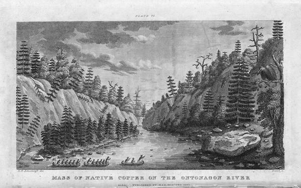
“Engraving depicting the [1820] Schoolcraft expedition crossing the Ontonagon River to investigate a copper boulder.”
~ Wisconsin Historical Society
But to conclude the narrative: on reaching camp, on our return, we learned that the chief, with several of this band, had been there, but had touched nothing, and according to his own account, had taken the trail for Lake Flambeau, in order to join a war-party, then organizing, of the Chippewas against the Sioux. Notwithstanding this story we fully expected to meet these fellows again at the mouth, and to whip them there if we could. But when we reached the place all was silent, and the lodges deserted.

Page 57: “Falls at the mouth of Montreal River.”
I will only add to this long story, that our captain’s order was never presented. We learned further, on reaching La Pointe, that the party which waylaid us had known of our journey from the first; that they had “smoked over it,” had dogged us the whole way up the lake, subsisting themselves by fishing, and that when we met they were nearly starved.
I will take my hearers but one stage further before closing this excursive ramble.
Charles William Wulff Borup
~ Minnesota Historical Society

Charles Henry Oakes
~ Findagrave.com
A few days brought us to the islands called by Carver “The Apostles.” On one of the largest of these, Madeline, at La Pointe, is located a general depot of the American Fur Company, for all the western parts of the lake, and the chain of lakes and rivers leading into it. It had become, in consequence, an asylum for all the old traders of that part of the country, and the temporary abode to great numbers of Indians. After pitching our tents on the beach, in front of the fort, amid a crowd of Indians and equally idle half-breeds, we were welcomed by the company’s factor, Dr. Borup, Mr. Oakes, the factor from Fond-dulac, and Mr. Bushnell, the Indian agent, and invited to all the hospitalities of the place.
During our whole voyage from the Sault we had not seen the face of a white man, except at the mission of L’Anse, and a casual fishing party. But here, at the end of our wandering, far from what we had been accustomed to consider the limits of civilization, we were greeted, in the families of these gentlemen, not only by features to which we had been so long strangers, but by all the attendant civilized refinements. The dress and manners of the East, the free converse with friendly voices of our own and the gentler sex, the music of a piano, the sound of the church-going bell and Christian services, seemed to us rather like a return to our homes than the extreme of a two-months’ journey in the wilderness.
It may interest my hearer to know in more detail what composed a post so remote, and which was to me so much a surprise.
La Pointe at that period was one of those peculiar growths known only to a era which has long passed away, or been banished to regions still more remote. What is called the company’s “fort” consisted of two large stores painted red, a long storehouse for fish, at the wharf, and row of neat frame buildings painted white. The latter were occupied by the half dozen families in the company’s employ. These dwellings, with the two stores, formed opposite sides of a broad street, in the centre square of which was planted a large flag-pole. Upon this street also clustered sundry smaller and unpainted log tenements of the French and half-breeds. Half a mile from the fort were the Protestant and Catholic missions. The former boasted a good frame mansion of two stories, attached to which was a school, numbering thirty scholars. The Catholic mission had a large number of followers, including the French and Indians. In all, the settlement contained about fifty permanent tenements. Beside these were perhaps an equal number of Indian lodges, irregularly disposed in vacant spaces, and adding to the size and picturesque character of the village. Several hundred Indians usually found constant employ in the fisheries at this place.
This was the oldest, as well as most remote, of the Jesuit missions in the North-west, having been established by Father Allouez, in 1665. It was then a gathering place of many Indian nations, and was hundreds of miles from the nearest French settlement.
It has additional interest from the fact that it witnessed the youthful and zealous labors of Pere Marquette, who came, in 1669, to take the place of Father Allouez, among the Ottawas, Hurons, and other tribes of the neighborhood. It was at La Pointe that Marquette planned that voyage of first discovery, exploration and missionary enterprise down the Mississippi which has rendered his name illustrious.

Page 61: “Pere Marquette. (From the statue at City Hall, Detroit.)”
In the families I have mentioned might be detected an intermixture of Indian blood, which detracts little even from the fairness of the daughters, and the ladies as well as the gentlemen are intelligent and highly educated. Their lives, when not occupied in business, are spent in reading and music; and during the long, cold winter, frequent rides are taken on the ice, upon which they pass from island to island in sledges drawn by dogs.
I could not but picture to my mind, outside of this intelligent circle, the festivities which marked this distant post, at that season, in the more palmy days of the fur trade; when it would be crowded with the hangers-on of such an establishment, returned-returned from their sojourn in the trapping grounds, or their toilsome voyages to and from Montreal and Quebec, bent on lavishing away their season’s earnings in days of idleness or debauch, and in “long nights of revelry and ease.”
Much of this old-time character still remained. The motley population, the unique village, the fisheries and furs, the Indian dances and pow-wows, the mixture of civilization and barbarism, the isolation, broken only be occasional and irregular arrivals from the world below,—made up a scene for which we were little prepared, which will not be easily forgotten, but of which I can give only this meagre description.
Indian Records of Ontonagon and Bad River
June 11, 2016
By Amorin Mello
![This is a partial reproduction of<strong> <br /> <em>Western Reserve and Northern Ohio</em></strong><br /> <em> <strong> Historical Society</strong></em><br /> <em><strong>[Tract] Number 41</strong></em><br /> <em> <strong> Ancient Earthworks - Northern Ohio</strong></em><br /> by Charles Whittlesey, circa 1877<br /> as published in<br /> <a href="https://books.google.com/books?id=EawKAAAAIAAJ" target="_blank"><strong><span style="text-decoration: underline;">Western Reserve Historical Society Publication, Volume 2</span>,</strong></a><br /> pages 38-39.](https://chequamegonhistory.com/wp-content/uploads/2016/06/wrhs-tract-41.jpg)
This is a partial reproduction of
Western Reserve and Northern Ohio Historical Society
[Tract] Number 41: Ancient Earthworks – Northern Ohio
by Colonel Charles W. Whittlesey, circa 1877,
as republished in
Western Reserve Historical Society Publication, Volume 2,
pages 38-39.
INDIAN RECORDS.

Autobiography of Okandikan
Autobiography of Kundickan, a Chippeway Indian.
The subjoined pictorial record of his life, was made many years since by a Chippeway of Lake Superior. He delivered it to the Hon. A. C. Davis, of Detroit, who placed it in the Museum of the Natural Science Association of that place where it is now. The tracing was made in October, 1875, by Bela Hubbard, of Detroit. The engraving is from a photograph by E. Decker of Cleveland, reduced to one-third the original size.
The signs or characters are cut with a knife on both sides of a flat piece of sugar maple wood, less than one-fourth of an inch thick, wrought out by the Indian himself, for this purpose. The upright lines at a, a, a, appear to be divisions in the narrative, for the purpose of grouping events. He explained to Mr. Davis that this board contained the principal occurrences of his life, which any other Chippeway could read. How it should be read, whether from right to left or the reverse, or whether the inverted parts are to be taken in connection with those below, is not settled. The partitions A and B are colored vermillion red. It corresponds with the general character of the Indian pictorial writing, of which numerous examples are given by Schoolcraft, and shows a close relation to the rock inscriptions of the United States. It embraces the usual variety of uncouth men, animals, and implements which characterize the rock sculptures. Between the two sides of the board there does not appear to be any connection in regard to the sentences or paragraphs, though there must be as to dates. They are all, without much doubt, the work of people in the condition of savages. I saw this Indian on the Ontonagon river in 1845. He purported to have seen Alexander Henry in that region in 1769-70, who was engaged there in mining for copper and silver.

“Pictograph C. Okundekund and his Band of Ontonagon – Michigan,” as reproduced from birch bark by Seth Eastman, and published as Plate 62 in Historical and Statistical Information Respecting the History, Condition, and Prospects of the Indian Tribes of the United States, Volume I., by Henry Rowe Schoolcraft, 1851. Okandian’s pictograph petition was one of several from the 1849 Martell delegation:
“By this scroll, the chief Kun-de-kund of the Eagle totem of the river Ontonagon, of Lake Superior, and certain individuals of his band, are represented as uniting in the object of their visit of Oshcabewis. He is depicted by the figure of an eagle, Number 1. The two small lines ascending from the head of the bird denote authority or power generally. The human arm extended from the breast of the bird, with the open hand, are symbolic of friendship. By the light lines connecting the eye of each person with the chief, and that of the chief with the President, (Number 8,) unity of views or purpose, the same as in pictography Number 1, is symbolized. Number 2, 3, 4, and 5, are warriors of his own totem and kindred. Their names, in their order, are On-gwai-sug, Was-sa-ge-zhig, or The Sky that lightens, Kwe-we-ziash-ish, or the Bad-boy, and Gitch-ee-man-tau-gum-ee, or the great sounding water. Number 6. Na-boab-ains, or Little Soup, is a warrior of his band of the Catfish totem. Figure Number 7, repeated, represents dwelling-houses, and this device is employed to deonte that the persons, beneath whose symbolic totem it is respectively drawn, are inclined to live in houses and become civilized, in other words, to abandon the chase. Number 8 depicts the President of the United States standing in his official residence at Washington. The open hand extended is employed as a symbol of friendship, corresponding exactly, in this respect, with the same feature in Number 1. The chief whose name is withheld at the left hand of the inferior figures of the scroll, is represented by the rays on his head, (Figure 9,) as, apparently, possessing a higher power than Number 1, but is still concurring, by the eye-line, with Kundekund in the purport of pictograph Number 1.”
Inscriptions on Clay Banks, Bad River, Ashland County, Wis.

2

1
A few representations of recently inscribed figures are given for the purpose of comparison with ancient stone inscriptions. A short distance below the portage, across a long, loop-like bend of the Mashkeg or Bad river, above the Odanah Mission, is a perpendicular bluff of clay, on the west bank of the stream. Steep clay and sand bluffs are common through the flat country below the Falls of Bad River. This one has been sheltered by a thick fringe of growing trees, from the wearing effects of storms. It presents quite a smooth, upright face of dry clay; that is easily cut with a knife, about fifty feet long, and about ten to fifteen feet long, and about ten to fifteen feet high. This space is completely covered with picture records, made by the Chippeways. No doubt many of them are old, but most of them have been made recently, or by men now living, often obliterating or cutting new inscriptions over old ones.

4

3
In my explorations on the waters of Bad river in 1846, 1849, and 1860, I passed them repeatedly, but having other objects in view, made only a few sketches. The effigies are grotesque outlines of animals, canoes, birds, fishes, men, women, trees, and other objects, animate and inanimate. My Indians and some of the half-breed voyageurs, professed to be able to read them. They said it was expected that every young man, when he was old enough to become a warrior, should retire to some solitary place and undergo a fast. The length of time he could do without food was a test of his bravery. Sometimes he perched in a tree, day and night, or sat on a rock or on a high mountain, without fire or shelter, in order to show his contempt of pain and exposure. In due time he naturally had visions, in which his destiny or chart of life, was disclosed. Weak constitutions are unable to fast more than three or four days. When the incipient warrior had satisfied himself that his mission on earth was fully disclosed to him, he returned to the tribe and was received a man. Their version of this ceremony, and its consequences agrees generally with that of Chingwauk to Mr. Schoolcraft in 1839, as related in vol. 1, pages 13-14, of his “North American Indians.” The symbols of his destiny were generally put upon record, in such a manner and in such a place as he saw fit, but generally on trees or rocks, along a traveled route. In some cases a full statement of the vision or visions, was written out in this pictorial mode, with his dodem or “totem” attached. I remember the meaning of only one, of which figure No. 2 forms a part. The tree with nine branches, and a hand pointing upward, signifies that the party making it had fasted nine days.

5
There is nothing in their customs to prevent other messages being left in such places. Their records include nothing historical in regards to the nations or their chiefs. Such matters are perpetuated by repetition from the old to the young, until every young man is thoroughly crammed. General story telling, and the recital of their traditions, is the literary life work of an Indian. His memory is a mental record, transmitted from generation to generation. The fidelity of such records is, however, very far from reliable.
Figures one to five are random copies from a large number of the Bad river effigies, not made to scale, but they are fair representatives of Indian pictography.
