Tyler’s Fork Location: Copper Lands
March 19, 2016
By Amorin Mello

“Map and Section Showing the Formations at the Junction of Bad River and Tylers Fork” by R. D. Irving, 1873. Reproduced from the Geology of Wisconsin: Volume III.
LETTER OF J. A. BAILEY, ESQ.,
IN REFERENCE TO THE
TYLER’S FORK PROPERTY.
———–
Office of Ashland Copper Mining Company,
Ashland County, Wis., Oct. 20, 1864.
Messrs. A. Whittlesey F. W. Bartlett,
Gentlemen:

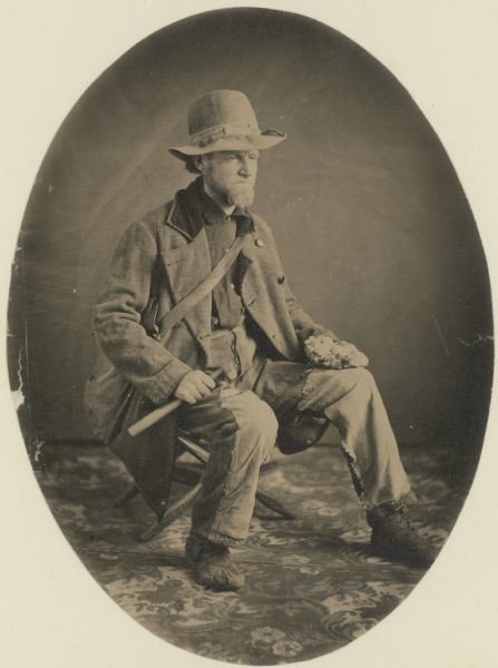
“Asaph Whittlesey dressed for his journey from Ashland to Madison, Wisconsin, to take up his seat in the state legislature. Whittlesey is attired for the long trek in winter gear including goggles, a walking staff, and snowshoes.” Circa 1860.
~ Wisconsin Historical Society
I have made an examination of the trap beds exposed between this and your location, upon the Copper Range, in Sections 15, 16 and 21, Town 45, North, Range 2, West, in this County, and have collected specimens (which are herewith forwarded) from the Ashland Company’s location, and from various points Eastward to your location.
The accompanying sketch of the territory referred to will assist you in locating the several points from which these specimens were taken, the figures upon the sketch indicating the points referred to.

Detail of the Ashland Copper Mine from 1873; located around what is now the main picnic area within Copper Falls State Park.
The specimens No. 1, are from the rocks in place in the bed of the West branch of Bad River, above the falls, near shaft No. 1, and contain a good per centage of native Copper. The copper bearing belt, exposed here across the formation, embraces a breadth of about 500 feet.
Specimens No. 2, are vein rock, from the transverse vein, in which our shaft No. 1 is being sunk. This shaft is now 35 feet deep, carrying small quantities of fine Copper all the way.
Specimens No. 3, are from the outcrop of the Herbert vein, near the junction of the East and West branches of Bad River, containing “gray ore,” or “gray sulphuret of copper.”
Specimens Nos. 4, 5 and 6 are of trap, taken from the rock in place, along Tyler’s Fork, at the points indicated on the sketch of corresponding numbers.
My explorations and survey have been extended only to a short distance East of the Section line dividing Sections 16 and 17.
The surveys have been carefully made with theodolite and chain, with the view to determine the true course of the copper bearing belt through the “Ashland Company’s” property, and that adjoining on the East; and as near as I can determine from the measurements and the character of the rocks exposed, the course of this belt is East and West, or nearly so, through Section 17, with indications of a curve to the Northward, as we approach to, and enter Section 16.
I have indicated on the sketch the position of what I consider the North line of the outcrop of the copper bearing belt. The South line is not determined, the rocks being covered by drift, sand, &c.
It will be proper for me to add that the productive trap formation, found in place above the falls, in the West branch, corresponds fully with the formation at the same elevation in Tyler’s Fork, on the Western boundary of Section 16; and I am clearly of the opinion that at that point the trap formation, when penetrated to a depth corresponding to that at the falls of the West branch, will be alike productive of copper, and that the most productive veins will be found running parallel with the formation.
Very respectfully, Yours, &c.,
J. A. BAILEY,
Supt. & Engineer A. C. M. Co.
—————-
A letter from Mr. E. Leehy, of Bad River Falls, dated Jan’y 6, 1865, states that in shaft No. 2, on the Ashland mine, several hundred feet South of No. 1, and in the productive belt, the copper rock was reached at 20 feet in depth, and the first blast threw out several pounds of native copper in pieces from the size of an egg down.

“Property on which ‘Silver Lead’ has recently been discovered.”
TYLER’S FORK LOCATION.
——-~~0~~——-
COPPER LANDS,
IN
SECTIONS 15 16 AND 21, TOWN 45, NORTH, RANGE 2, WEST.
640 ACRES.
ASHLAND COUNTY, WISCONSIN.

Detail of Township 45 North, Range 2 West, from Charles Whittlesey’s 1860 Geological Map of the Penokie Range.
This location covers a great part, if not all of the breadth of the productive trap formation. The outcrop of the strata is here nearly East and West, with a curve to the North-Eastward on or near this land. The greatest length of the location is North and South, and therefore crosses the formation nearly at right angles. At the Northern end, is the conglomerate and sand rock, which overlies the trap beds. These beds are better exposed at the West, in Section 17, on the Ashland Copper Company’s land, where they are now working and whatever developments may be made there will apply to this property. The strata have a sharp dip to the North, and are thus exposed at the edges, being nearly vertical. Next below, and South of the conglomerate, is a band of black and red trap, of a compact and rather flinty structure, about three hundred (300) feet thick, in which there are numerous transverse veins, cutting the strata at various angles. These are visible in a deep gulf formed on both forks of Bad River, that unite in Section 17. Somme of these cross veins carry copper, both native and as an ore in the form of grey sulphuret. They also carry as vein matter, chlorite, cale, spar, and flucan, or red and green magnesian clay. There are also narrow beds of trap, interstratified with the hard ores, which are softer, owing to a large portion of laumonite. I do not regard the true veins in the upper beds, as likely to furnish mining ground; but as highly valuable indications, which are to be followed into the more promising strata lower down in the system. Next below the hard beds, to the South, is a belt of trap rocks, whose composition and texture I regard as highly favorable.
The Ashland Company is sinking on a cross or transverse vein, at the Southern border of the hard beds; which in the course of 75 or 100 feet along their inclined shaft, will enter what I consider productive ground. The thickness of this ground is not determined, but what I have seen in the branches of the river exceeds half a mile. It is not, however, all alike, as there are in it layers possessing different characters, corresponding in this respect other parts of the trap range in Michigan and Wisconsin.
The stratum at the head of the falls, on the West fork, where the Ashland Company is at work, has been closely examined over a breadth of about 50 feet, and carries small pieces or nuggets of native copper throughout. It is a soft brown amyglaloid, which small bunches of chlorite, spar and laumonite; some prehnite and quartz, in which the copper is found. Lumps weighing one to two pounds have been obtained from this bed away from any appearances of a vein. This is the general character of the mineral belt on Section 17, which I consider as the true mining ground of this part of the range. All these beds are embraced in our location, at a distance of ¼ to ⅓ of a mile on the East. In Sections 16 and 21, the exposure of rock is not as extensive as it is upon 17, for the rocks are covered by drift clay, sand and gravel, except in the streams.
There is no canoe navigation on Tyler’s Fork, or the Upper Bad River, so swift is the current and narrow and crooked are the channels.
Tyler’s Fork comes out of the mountains about twelve miles southeast by south from Woods’s [at Leihy’s Saw Mill], in a chasm, two hundred feet deep deep, in the red sand-rock and conglomerate. The junction of its ten branches takes place in this narrow gulf or ‘cañon,’ the eastern branch making a plunge of forty-two feet, succeeded, as you ascend, by a series of chutes over trap-rocks forty feet in one-fourth of a mile. Mr. D. Tyler, of the Charter Oak Company, made a location here, and built a rude cabin at the edge of the falls.”
Geological Report on That Portion of Wisconsin Bordering on the South Shore of Lake Superior. Surveyed in the Year 1849, Under the Direction of David Dale Owen, United States Geologist, by Charles Whittlesey, Head of Sub-Corps, page 433.
“Studio portrait of geologist Charles Whittlesey dressed for a field trip.” Circa 1858.
~ Wisconsin Historical Society
The East, or “Tyler’s” Fork, shows the trap beds in its channel a large part of the way through Section 16; and they are visible in the small creek that empties into it on Section 21, from the South. To examine the metal-bearing bed, of which I have spoken, after it reaches this location, the rocks must be uncovered by trenches or shafts in the sand and gravel, after having determined the true course of the bed. The search for cross veins can be easily made in the channel of Tyler’s Fork. This is a stream of considerable value for water power, the fall in your property being sufficient for two dams, and the flow of water sufficient for a saw mill. The Exploration of the porous laumonite beds, will be somewhat tedious; but the close proximity to those on the Ashland Company’s property will be of great assistance. As soon as it is demonstrated that these deposits of fine and nugget copper are remunerative at one point on the range, it gives new value to the whole system. Copper deposited in this mode, in other mining districts, has been found to be more uniform over long distances, than it is in veins; because these ores are liable to pass out of the property formations, and into a diabase rock. These copper-bearing longitudinal courses should therefore be most thoroughly searched. In this region, stamp mills can be worked in most cases by water power; a heavy and regular bed can be stoped and broken up ready for the mill, at a much cheaper rate per fathom, than vein matter. The improved stamps, crushers and washers, have of late years much reduced the expence of working mineral-bearing rock. The absence of masses of native copper in the Ashland district, is not now so important as it was when the first explorers made their location here. On this property, the length of the copper-bearing beds is something over a mile, and their breadth at least half a mile. As they extend to a greater depth than any mine can be worked, there is no fear of exhaustion.
CHAS. WHITTLESEY
Geologist and Mining Engineer.
Cleveland, Ohio, Jan. 1st, 1865.
John Johnston Describes La Pointe (1807-09)
June 12, 2014

Susan Johnston, or Ozhaawashkodewekwe, the wife of John Johnston ( Chicago Newberry Library)
The name of John Johnston will be familiar to those who have read the works of his son-in-law Henry Schoolcraft. Johnston (1762-1828) was born into the Anglo-Protestant gentry of Northern Ireland and came to the Chequamegon region in 1791. After marrying Ozhaawashkodewekwe, the daughter of Waabojiig, he cemented his alliance with a prominent Ojibwe trading family. The Johnstons settled at Sault Ste. Marie, and their influence as a fur-trade power couple in the eastern part of Lake Superior parallels that of Michel and Madeline (Ikwezewe) Cadotte around La Pointe. The Johnstons played a key role in resistance to American encroachment in Lake Superior during the War of 1812 but later became centrally-connected to the United States Government efforts to establish a foothold in the northern country. A nice concise biography of John Johnston is available in the Dictionary of Canadian Biography Online.

Roderick MacKenzie (Wikimedia Commons)
In 1806, John Johnston was trading at the Soo for the North West Company when he received a printed request from Roderick MacKenzie, one of the heads of the Company. It called for information on the physical and cultural geography of the different parts of North America where the NWC traded. Johnston took it upon himself to describe the Lake Superior region and prepared An Account of Lake Superior, an 82-page manuscript.
By the end of the 19th century, the manuscript had found its way to Louis Rodrigue Masson (a grandson-in-law of MacKenzie) who edited it and published it in Les Bourgeois de la Compagnie du Nord-Ouest; recits de voyages, lettres et rapports inedits relatifs au Nord-Ouest Canadien (1889-90). The Masson archives were later donated to the McGill University Library in Montreal and are now digitized.
Much of Johnston’s account concerns the Sault and the eastern part of Lake Superior. However, he does include some information from his time at La Pointe, which is reproduced below. While it doesn’t say much about the political topics that I tend to focus on, this document is fascinating for its geographic toponyms and terminology, which is much more reflective of the 18th century than the 19th. Enjoy:
[Ojibwe names for geographic locations are taken from Gidakiiminaan: An Anishinaabe Atlas of the 1836 (Upper Michigan), 1837, and 1842 Treaty Ceded Territories (GLIFWC 2007)].
[pg. 49-56]
…The coast runs almost due West from the Kakewiching or Porcupine Mountain to the Montreal River a distance of fifteen leagues, and the beach is a shelving rock the same as the Mountain all the way with here and there a little gravelly strand. There is but one river, and that a very small one, from the Black to the Montreal River. This last takes its rise from the Wa[s]wagonnis or flambeau Lake about 80 leagues to the Southwest: it is one continued rapid from within ten leagues of its source, and a few hundred yards from the entrance has a fall of fifteen or twenty feet: – there are two high clay banks which distinguish the entrance. The lands tends to the Northwest and is a stiff clay for three leagues rent into deep gutters at short distances; it then gradually declines to a sandy beach for three leagues farther until you arrive at the Mouskissipi or bad river so called from its broad and shallow stream in which it is almost impossible to mount even an Indian Canoe.
It takes its rise from the Ottawa Lake about 125 leagues to the Westward: the Lake has its waters divided very partially as the chief part takes a southerly course and falls into the Mississipi and is called Ottawa River.
The Flambeau Lake has its waters also, the better part taking a southeasterly direction to the Mississipi and is called Ouisconsin or the medicine River. From the bad river the coast runs north four leagues to Chogowiminan or La Pointe; it is a fine strand all the way, behind which are sand hills covered with bent and sand cherry shrubs – and behind the hills there runs all the length a shallow bay which is a branch from the Bay of St Charles.
At Lapointe you are nearly opposite the Anse or Keegwagnan the distance I should conjecture to be twenty leagues in a straight line.
The Bay of St Charles runs southwest from La Pointe and is four leagues in depth and better than a league broad at the entrance. Opposite Lapointe to the Northeast is the Island of Montreal, one of the largest of those called the twelve Apostles. On the main land the Indians had once a Village amounting to 200 huts but since the Traders have multiplied, they no longer assemble at Netoungan or the sand beach, but remain in small bands near their hunting grounds. When you double the Point of Netoungan the coast tends nearly west and is composed of high rocky points of Basaltes with some freestone; there is one place in particular which is an humble imitation of the Portals but not near so high: it is about a leagues from La Pointe and is a projection from the highest mountain from Porcupine bay to fond du lac, a distance of more than 45 leagues. From the Summit of the Mountain; you can count twenty six Islands extending to the North and North east, Islands which has never been visited by the boldest Indians and lying out of the way of the N.W.Co’s Vessel: have a chance of never being better known. Of the Islands opposite La pointe ten or twelve have been visited by the Indians, some of which have a rich soil covered with oak and beech, and round all of them there is deep water and fine fishing for Trout. The Trout in this part of the Lake are equal to those of Mackinac in size & richness – I myself saw one taken off the Northeast end of Montreal Island that weighed fifty two Pounds. How many Islands this Archipelago actually contains will not be easily ascertained; but I take Carribou Island to be the eastern end of the chain. It lies a little to the Southward of the course of the Co’s Vessel, is about three miles round, has a flat shore and good anchorage, and is allowed to be half passage from Camanitiquia to St. Mary’s. However, no other land is seen from it by the Vessel; but that may be owing to the Islands being low and lying too much to the Southward of the course. It is to be observed this account of the number of Islands is upon Indian Authority, which though not the best, is still less apocryphal than that of the Canadians.
There are several rivers between Lapointe and Fond du Lac, the distance is allowed to be thirty leagues, and the breadth of the bay from a high Rocky point within a leagues of Netoungan to the roche deboute, or the upright rock, which is a lofty Mountain right opposite, cannot be less than twenty leagues.
The Metal River is within ten leagues of Fond du Lac; it is only remarkable from the Old Chief of Lapointe’s having once found a large piece of Silver ore in descending it. The Burnt river is three leagues to the Westward of Metal river; it issues from one of the Lakes of the little wild Oats Country about thirty leagues to the Southward, and is only navigable for small Canoes: it has several rapids and the Portages are dangerous, several of them lying along the edge of the river, and over precipices where one false step would be fatal. It empties itself into the Bay of Fond du Lac through a stiff Clay Bank which continues all along the shore until it joins the sands of Fond du Lac river.
About sixteen years ago, Wabogick, or the Whitefisher, the Chief of Lapointe, made his sugar on the skirt of a high mountain four days march from the entrance of the river to the south west, his eldest daughter then a girl of fourteen with a cousin of hers who was two or three years older, rambling one day up the eastern side of the Mountain came to a perpendicular Cliff, which exactly fronted the rising sun, and had an apparently artificial level before it, on which near the base of the Cliff they found a pieces of yellow metal as they called it, about eighteen inches long, a foot broad, and four inches thick; and perfectly Smooth: – it was so heavy that they could raise it with great difficulty: – after amusing themselves with examining it for some time, it occured to the eldest girl that it belonged to the Gitchi Manitou or the great spirit; upon which they abandoned the place with precipitation. As the Chipeways are not Idolators, it occurs to me that some of the Southern tribes must have once Migrated thus far to the North, and that the piece, either of copper or gold, is part of an alter dedicated to the sun. If my conjecture is right, the slab is most probably gold as the Mexicans have more of that Metal than they have of copper. I have often regretted the premature death of the Chief the same autumn that he told me the story, as he had promised to go and bring it to me if he recovered: and circumstances since have precluded my making any attempt to procure it.
The river of Fond du Lac is deep, wide and serpentine, but is only navigable for four or five leagues from its entrance. The Portages are many and different until you arrive at the sand Lake, where the tribe of Chipeways, called the Pillagers, reside. The furs from this country are the best assorted of any on the Continent; and the quantity would much increase were it possible to repress the mutual incursions of the Scieux and Chipeways, who caray on perpetual war. The tract of country lying between the two nations for near 150 leagues in length and from thirty to forty in breadth is only visited by stealth, and if peaceably hunted would be more productive than the richest mine of Peru…
[pg. 75-76]
…The wild Vine is not found at St Mary’s nor any where along the lake except at Lapointe, where however it is scarce. The wild Hop is very abundant at Lapointe but I do not recollect to have seen it elsewhere. There are three distinct species of Whortleberry. The blue or real whortleberry is by far the most wholesome and agreeable: the abundance of this fruit on the borders of Lake Superior is incredible; the Indians dry great quantities of them which they preserve during the winter, and which make an agreeable taste when repeatedly washed in warm water to take away the smoky taste from them. The black Whortleberry grows much higher than the blue; its seeds are very hard and astringent – the largest species the Indians call Hareberry; it grows to 2 or 3 feet high and bears a fruit as large as a cherry, but it is neither so agreeable nor so wholesome as either of the others…
 Poisson Blanc (whitefish), Broche (pike) and Truite Comune (Lake Trout) from the Codex Canadensis.
 (Photo: Wikimedia Images)
 This is all for now on John Johnston, but this document is a potential jumping-off point for several potential research topics. Look for an upcoming post on the meaning of “La Pointe” and “La Pointe Band.”
