Edwin Ellis Incidents: Number I
February 11, 2017
By Amorin Mello

Originally published in the June 16th, 1877, issue of The Ashland Press. Transcribed with permission from Ashland Narratives by K. Wallin and published in 2013 by Straddle Creek Co.
EARLY RECOLLECTIONS OF ASHLAND.
“OF WHICH I WAS A PART.”
Edwin Ellis, M.D.
~ Western Reserve Historical Society
My Dear Press:– In these joyous days of Ashland’s history, when we are all made glad by the completion of that great enterprise – the Wisconsin Central Railroad – when from banishment and isolation from the populous portion of our State and from the great world we in one day are brought in close contact with and feel the throbbings of the pulse of commercial and social life, it may be of interest to some to recall a few incidents of the early history of our town and its vicinity.
The years 1853 to 1857 were noted in the West for adventure and enterprise in pushing into new regions and laying out and building new towns.
Land Office Fraud;
Barber Papers Prologue;
Part VI of Sketch of Vincent Roy Jr.
In 1853 the site of Superior City had been pre-empted and in 1854, laid out into regular lots and blocks, and the work of a new city begun. The site had attracted the attention and capital of some of our ablest men. It was backed by stronger political influences than ever combined to lay the foundations of any town in the west. Among its proprietors were many leading members of Congress and of the Cabinet, especially from the South. The most sanguine expectations of its future greatness were entertained, for it commanded a scope of country as great as that paying tribute to Chicago. Its lots were sold at fabulous prices. It was in 1855 and 1856 – probably the most talked of town in the Union.
The temporary success of Superior kindled a blaze of speculation, which spread far and wide in Wisconsin, Minnesota and Michigan.
Some of the founders of Superior at the map, saw stretching away to the South-west from the Apostles’ Islands, a deep bay, extending far inland, as if reaching forth to reach the tide of commerce flowing northward from the Gulf and the Atlantic.
This was our Chegomegon or Long Island Bay. The report of Foster and Whitney also told of mountains of iron ore, which must find its way into the channels of commerce, by the waters of this bay. An important town, it was thought, must spring up near its head.

Martin Beaser
~ Western Reserve Historical Society
While plans were maturing for the occupation of this site, we learned that another party had been attracted by the same considerations that moved us, and that Martin Beaser, Asaph Whittlesy, and Geo. Kilbourn had entered upon and claimed about three hundred acres under the townsite law. The land had not yet been surveyed, and of course could not be entered or pre-empted. The two latter gentlemen were on the spot, having arrived in the summer of 1854. But we were not deterred by these anticipations of our plans.
Early in February, 1855, Edwin Ellis, as the representative of several enterprising capitalists of St. Paul, left the latter city with one companion, Cyrus A. Rollins, to examine the situation and site, and if thought advisable and practicable, to make a lodgement there. The writer was then in full prime and vigor of early manhood, and full of ambition and bright expectations. The way from St. Paul was through an unbroken wilderness. The Lake Superior & Mississippi Railroad had not been conceived. In truth, no railroad had then approached within three hundred miles of the great Lake. The present city of Duluth in its visions of the near future – the Damascus between the Atlantic and Pacific – the halting place of the North Pacific caravan, bringing to New York and London, the wealth of India, and China and Japan, and the Islands of the South sea – was then only occupied by the wild Indian.
Emmet Jefferson, who subsequently pre-empted the site of Duluth, was one of our party from St. Paul; but for many years he had slept in his last sleep. Three or four other adventurers were with us and though it was cold and the way hard, we were a wild and joyous party of young men, going forth to seek our fortunes,– not doubtful of success.
At Superior we first saw the Great Lake. Half a dozen houses – a store or two and the beginnings of a hotel, comprised all of that rival to Chicago.
Among our acquaintances formed there, of which there were several pleasant ones, were Capt. Markland, a soldier of the Mexican war, a lawyer by profession, a man of culture, courteous in manner and stately in his bearing;– Washington Ashton, the pioneer publisher of Superior, and Colonel Carleton, who had been for several years a resident at Fond du Lac, and whose name is perpetuated by the name of a county in Minnesota. All of them have been long years dead.
Having rested a day and bade adieu to our traveling companions, already dear to us as the sharers of our toils, we turned our faces towards the east. We were fortunate in securing as a pilot on our untried voyage, Baptiste Gauden – mail carrier between Superior and La Pointe. Here we first saw a dog train, which relieved us of our packs; and at night Baptiste assisted in pitching our camp, “a day’s march nearer home.” He “still lives,” and devotes much of his time to the service of the Roman Catholic Church, of which he is an obedient and devoted son.

George Riley Stuntz had a settlement and sawmill near the mouth of the Iron River, 1852.
~ General Land Office Records

Detail of foot trails in the Sioux River Valley, 1855.
~ General Land Office Records
Leaving Superior late in the forenoon, we arrived at Iron River, twenty miles away; where we were happy to find shelter in a logging camp, full of robust, hearty, whole-souled men, some of whom had come from cultivated homes in the east. By some means strange to most of that company, the traveling pilgrim discovered a brother of the mystic tie, with whom he passed a pleasant evening, thankful for that fraternal bond, which makes strangers friends and brothers at sight.
Leaving Iron River the next morning, two days march brought us to La Pointe via the valley of the Sioux river, passing through the wilderness then, which is now the cultivated vale, made classic by being the dwelling place of the “Sage of Avoca;” the peer in farming to the immortal Horace, who has earned his title to the peerage by “causing two blades of grass to grow, where but one grew before he came,” and of him we may say:
Remote from cities lived a swain,
Unvexed with all the cares of gain;
His head is silvered o’er with age,
And long experience makes him Sage.

Antoine Gordon
~ Noble Lives of a Noble Race by the St. Mary’s Industrial School (Odanah), page 207.
At La Pointe the first object to meet our profane view were numerous large wooded crosses ten to fifteen feet high, in different parts of the town, erected by the pious zeal of the faithful believers in the then new dogma of “Immaculate Conception.” We saw also an imposing procession of French mixed bloods, escorting a fat, good natured looking priest through the street, under a gaudy canophy, borne by four devout servants of the Church. This also was in honor of the same dogma.
We put up for the night at the only hotel of the place, kept by Antoine Gauden, whose aged father, that very night, amid the chanting and prayers of the virgin saints of La Pointe, passed into the presence of the Eternal. La Pointe at that time was of much greater importance than at present – the most important town on the Lake west of Ontonagon. It was the annual gathering place of several thousand Indians, who then received their annual payments. It was the center of the fish trade for all this part of the Lake. It had, also, quite an extensive fur trade.

Samuel Stuart Vaughn
~ Western Reserve Historical Society
Julius Austrian had an extensive store of general merchandise and transacted a large business. Hon. S.S. Vaughn, one of Ashland’s present most substantial citizens, was then a young merchant at La pointe, where by close attention to business, he was laying the foundation of the fortune he has since achieved. Wm. E. Vantassel, Government Blacksmith for the Indians, a descendant of an old Knickerbocker family was there – a very skillful workman and a very genial man. In old age he now resides near Stillwater, Minnesota. Francis McElroy was also there, full of life and energy. And last but not least, I must mention John W. Bell, Esq, who even then had lived on the Island more than twenty years, and whose recollections carried him back till he could almost hear the war whoop of the Sioux and Chippewas as the latter drove their old enemies forever away from the land of the Ojibwas. He has for many years been the “Patriach” of the Island, and is much esteemed by his neighbors.

Frederick Prentice
~ History of the Maumee Valley by Horace S Knapp, 1872, pages 560-562.
Resting one night, on the following day we started across the bay on snow-shoes, reaching the shore near the Kaukaugon river. We followed the coast west, and at nightfall we found tracks leading up the ravine, a few rods from where the railroad track now touches the water of the bay. We found here a log house, built by Lusk, Prentice & Co., for purposes of trade and with the plan for the occupation of the site. Here we passed our first night. The ruins of the shanty may be seen on the block now occupied by the residence of Ferinand Schupp. Adolphus Bart, the clerk of the company, was in charge and made us welcome with his good cheer. He is now a lawyer in the State of New York.
To be continued in Number II…
Asaph Whittlesey Incidents: Number I
February 9, 2017
By Amorin Mello

Originally published in the February 16, 1878, issue of The Ashland Press. Transcribed with permission from Ashland Narratives by K. Wallin and published in 2013 by Straddle Creek Co.
Early Recollections of Ashland: Number I
by Asaph Whittlesey

Photograph of Asaph Whittlesey from the Wisconsin Historical Society.
Our first arrival at La Pointe being so intimately associated with the settlement of Ashland, I have determined to make our arrival there the subject of my first letter.
It was among the first days of June, 1854, that George Kilburn, Jr., myself and wife and only child, Eugenia, (then some eighteen months old,) made a landing at La Pointe with a view to remain permanently in the country. Well do I remember the beautiful “town,” spread before us as we merged from the “old log warehouse” through which we passed in reaching the shore, while the general appearance was that of neatness and comfort.

Photograph of Julius Austrian from the Madeline Island Museum.
We had already made the acquaintance of Mr. and Mrs. Julius Austrian, having had the pleasure of their company up the Lakes, and had made many inquiries of them as to the place of our destination. From this time forward we found Mr. and Mrs. Austrian to be most agreeable neighbors and associates, and these young “brides” spent much of their time together, and not unfrequently did the evening air carry to listening crowds our notes of “Good old Colony times,” and “There’s no place like home,” still fresh in our memory.
La Pointe at this time was the second in importance of towns upon the Lakes, Ontonagon taking the lead.
Within a few days after our landing, we were fully organized as “house keepers,” under the same roof with Mr. and Mrs. George Starks, now residents of Bayfield; who proved to be most excellent neighbors, and never did a single roof cover a more harmonious trio of families.
We had, however, a common “foe” to encounter, visions of which filled our dreams and harassed our waking moments. This “foe” was the everlasting “bed bug,” more numerous and more determined in their onslaught than is the “Russian Army;” while this mixture of Dutch and Yankee blood served to satisfy their ravenous appetites. We had heard of this race before, but this was the first time we had met in open combat, face to face. It was our custom regularly before retiring to rest to go into combat with them armed with “wooden spads,” with which we slaughtered them by the quart. Our plan was to remain awake an hour or so after retiring to bed, when we would strike a light which was a signal for a field fight. It was an exciting scene to witness their ranks surrounding us on every hand, while the sheets of our bed seemed dyed in human blood. One means of our defense was to have the bed posts stand in molasses; but this only put them to the trouble of marching to the ceiling above from which they dropped upon us like hail; of course all these contingencies helped to make my wife good natured, and strengthen her attachments to the country. This condition of things lasted while we remained occupants of the building, and when we, in our weakness from loss of blood, staggered forth to make us a home elsewhere, we were filled with anxiety as to the safety of our German neighbors.
“Dr. Borup, the agent for the American Fur Company, (who have an extensive trading-post at this place,) has a superb garden. In walking through it with him, I saw very fine crops of the usual garden vegetables growing in it. His red currant bushes were literally bent down beneath their weight of ripe fruit. His cherry-trees had also borne well. Gooseberries also succeed well. The doctor also had some young apple-trees, that were in a thriving condition. Poultry, likewise, does well. Mrs. B. had her yard well stocked with turkeys, geese, ducks, and chickens.”
~ “Morgan“ at La Pointe during 1845.
As I have before stated, the general appearance of the island was most attractive. The garden of Mr. Austrian was laid out most tastily. We found there a large variety of fruit trees, apples, plums, cherries, etc. Also large quantities of currants and strawberries; but the crowning attraction was the “grape bower,” affording a most attractive lounging place. Here also a merry party, consisting, so far as my recollection serves me, of the following persons: Mr. and Mrs. Julius Austrian, Rev. John Chebohm, (who, I remember, asked the blessing at the table,) Marks Austrian, Mr. H. Mandelbaum, Henry Smit, Mr. and Mrs. Hocksteiner, Mr. and Mrs. George Starks, old Mr. and Mrs. Perinier, Mr. and Mrs. Asaph Whittlesey, and I think Mrs. William Herbert, and a Mr. Roy, celebrated the
“FORTH OF JULY,” 1854.
Being a curious mixture of Americans, Jews, Germans, French and Austrians, no two of whom could carry on a very extensive conversation, for want of a knowledge of the languages, so that our toasts were mainly received in silence, nevertheless the day was passed most pleasantly, while the reading of the Declaration of Independence by Asaph Whittlesey, marked it as a day for national celebration.
To be continued in Number II…
Ashland, Wisconsin: Its Early Days
November 29, 2016
By Amorin Mello
Magazine of Western History Illustrated
November 1888
as republished in
Magazine of Western History: Volume IX, No. 1, pages 12-17.
—
ASHLAND, WISCONSIN:
ITS EARLY AND PRESENT DAYS.
—

Detail of Lapointe du Saint Espirit and Mission du Saint Espirit from Claude Allouez Map of New France, 1669.
~ Research Laboratories of Archaeology
If the reader will look at the map of the United States, he will see on its northern boundary the largest body of fresh water in the world – Lake Superior, called by the Ojibways Kitche Gumi, “The Big Water.” It lies between 46 and 47 degrees north latitude, and stretches east and west through eight degrees of longitude. Its coast-line is nearly two thousand miles in extent, forming some of the finest natural harbors in the world. Its surface is six hundred and thirty feet above the ocean level, while its bottom in the deepest parts is four hundred feet below the level of the tide-waters. As you come from the east end of the lake, St. Mary’s river, approaching its western extremity, you will, from the deck of the steamer, notice a group of beautiful islands – the same islands which, more than two hundred years ago, met the gaze of Fathers Marquette, Allouez and Mesnard, and which, in their religious zeal, they named the “Apostles’ Islands,” thinking that in number they corresponded with the number of our Savior’s disciples. One of these they named “Madeline,” from a favorite saint of their own “Belle France,” and to commemorate one of the most noted churches of Paris.

Detail of “The 12 Apostles” from Captain Jonathan Carver’s journal of his travels with maps and drawings, 1766.
~ Boston Public Library
These islands in ancient times were doubtless a part of the main, as was also the land now lying under Ashland bay. Underlying them was sandstone, rising from twenty to one hundred feet above the water, and horizontal. The great glaciers coming from the north, and moving in a southwest direction, cut channels in the sandstone, forming these islands, and scooping out of the solid rock the large basin which, in after years, received the name of Chaquamegon bay, and which is now known as Ashland bay. This was the first prophecy of the city of Ashland. In the times, millions of years before this, the vast deposits of iron ore had been upheaved and stored along the south shore of the lake, to subserve the designs of the Mighty Builder in the development of that commerce of which we now see but the earliest down, and of whose future extent we can form but a faint comprehension. Chaquamegon, Le Anse and Marquette bays are the natural outlets on Lake Superior for the rich mineral deposits which line its southern shore.
The formation of Ashland bay was therefore not accidental, but in harmony with Eternal plans. It is protected from the storms of the lake by a long, low, sandy point, and also by the Apostles’ islands. Into it open from the lake three broad channels, with a depth of water ample for the largest vessels, called the North, Middle and South channels. Under these islands, vessels coming from the wild storms of the open lake are secure. It is the sailor’s haven of safety.

1834 Map of LaPointe by Lyman Warren for the American Fur Company.
~ Wisconsin Historical Society
The first settlement on the bay was made by the American Fur company in the early part of the present century, on the beautiful Madeline island, and named La Pointe. It continued for many years the headquarters of a flourishing fur and fishing trade. About 1830 a Protestant and, soon after, a Catholic mission were established there, and churches built by them, in which devoted missionaries labored to Christianize and civilize the Indians whose homes were here and in the surrounding country. Here toiled Rev. Sherman Hall, a missionary of the American board, and Rev. L. H. Wheeler, and also that devoted man, now known to us as Bishop Baraga. These have all passed away. La Pointe, then the most populous and active village on the lake, is now, alas, “The deserted village,” and is visited alone in veneration of its past memories.

Map inset of Chequamegon Bay with Houghton, LaPointe, Bayfield, Ashland, and Bay City.
~ Wisconsin Historical Society
On the west shore of the bay, opposite La Pointe, is the beautiful town of Bayfield, founded by Honorable Henry. M. Rice in 1856. It is the terminus of the C., St. P., M. & O. railroad and the headquarters of a flourishing fish and lumber trade, and one of the most charming summer resorts on the lake.
On the west shore of the bay is also the flourishing town of Washburn – named in honor of Wisconsin’s governor, Cadwallader C. Washburn. It is the favorite town of the Omaha railroad, and has several large saw-mills, and is an active and enterprising town.
Asaph Whittlesey circa 1860.
~ Wisconsin Historical Society
The first settlement on the spot where Ashland now stands was made, in 1854, by Asaph Whittlesey and George Kilborn, both natives of the Western Reserve, Ohio. The lands were not as yet surveyed, so that they could not preëmpt them, and there was as yet no Homestead law. For this reason they, with Martin Beaser, then living in Ontonagon, Michigan, laid claim, under the “Town Site” law, to about three hundred acres, embracing their log houses and small clearing. They platted this into town lots in 1855, and subsequently were allowed to enter their lands as claimed, and in due course received their title. In February, 1855, Edwin Ellis, a graduate in medicine, in the University of the City of New York, of the class of 1846, came on foot through the woods from St. Paul to the bay. He had been engaged in the practice of his profession in his native state – Maine – till 1854, when, attracted by the prospect of wider fields for enterprise in the new west, and by the advice of Judge D. A. J. Baker, his brother-in-law, then living in St. Paul, he came to Minnesota.

Edwin Ellis, M.D.
~ Commemorative Biographical Record of the Upper Lake Region by J.H. Beers & Co., 1905, pages 16-18.
The years 1853 to 1857 were years of wild speculation. The states of Wisconsin and Minnesota especially were covered with rising cities – at least on paper. Fabulous stories of rich silver, copper and iron mines on the south shore of Lake Superior attracted a multitude of active young men from the eastern states. The city of Superior had been laid out, and its lots were selling for fabulous prices. The penniless young man of to-day became the millionaire to-morrow. The consequent excitement was great, and in the event demoralizing.
The Bay of Ashland, stretching far in-land, the known vast deposits of iron near the Penokee Gap, whose natural route to market was evidently by Chaquamegon bay, indicated with moral certainty that at its head would rise a commercial mart which should command a wide extent of country. The vast forests of pine were then hardly thought of, and no efforts made to obtain them. The lands were unsurveyed, and all the “squatters” were, in the eye of the law, trespassers. Nevertheless, the new-comers ran “spotted” lines around their claims and built log-cabins to hold them, and began to clear up the land. In June, 1855, Dr. Ellis went on foot to St. Paul, and thence to Dubuque, Iowa, and secured from the surveyor-general an order to survey four townships about the bay, embracing the site of the present city of Ashland. In the meantime, many settlers had come in and preëmpted lands in the neighborhood. In the fall of 1855 many of them were enabled to prove up and get titles to their lands.
Portrait and biography of Frederick Prentice; the “first white child born in … Toledo.”
~ History of the Maumee Valley by Horace S Knapp, 1872, pages 560-562.
In the winter of 1855 Lusk, Prentice & Company, who had a trading-post within the present limits of Ellis’ division of Ashland, built a dock for the accommodation of the settlers coming to the new town. It was built of cribs, made of round logs sunk in the water about twenty feet apart. From one crib to another were stringers, made of logs, flattened on the upper surface, all covered with small logs to make a roadway. On the docks were piled several hundred cords of wood for the purpose of “holding” the dock from floating away, and to be sold in the summer to the steamboats which should come to bring supplies and begin the commerce of the town. The evening of the second day of April, 1855, saw the bay full of ice, slightly detached for a few feet from the shore, but with no sign of an immediate opening of navigation.

Portrait of Martin Beaser on page 24.
The next morning no ice was in sight, nor a vestige of the dock to be seen. Floating timber and cord-wood covered the bay. Till then the settlers had no idea the power of the floating ice moved by the tide of the bay. But they were not discouraged. The following winter two other docks were constructed – one by Martin Beaser, at the foot of what is now called “Beaser Avenue,” and the other by Edwin Ellis, near where Seyler’s foundry now stands.
These were also crib-docks, but the effort was made to anchor the cribs. There were no rocks to be had on the side of the bay where the docks were built, for which reason Mr. Beaser filled his cribs with clay, dug out of the banks. Dr. Ellis hauled stone across the bay, and filled as many of his cribs as possible, and on the top of the dock also piled several hundred cords of wood, and the settlers with anxious faces watched the departure of the ice. The shock came, and the docks afforded little resistance. The cribs filled with clay were easily carried. Those filled with stone stood better, but that part of those above water, and near the outer end, were swept away. The labors of many weary days and much money was thus swept away. There was, however, enough of the Ellis dock left to afford a landing to the few boats that came with supplies for the people.

Survey of Frederick Prentice‘s Addition of Ashland near the Gichi-wiikwedong village.
“It is in this addition, that, the Chippewa River and the St. Croix Indian trails reach the Bay, and for the purpose of accomodating the trade, already flowing in on their routes, a commodious store has just been built”
~ Wisconsin Historical Society
Translates as “Big Bay” in Ojibwemowin.
Traditional place-name for Ashland, WI.
Anglicized version of Gichi-wiikwedong.
Prentice Park and Maslowski Beach.
Area is famous for artesian wells.
“This was all Indian land then, but [Asaph] Whittlesey believed in take time for the forelock, looking he said, for a place that ‘might prove to be the most available point for a town, at or near Equadon (pronounced E Quay don, the second syllable emphasized.) The word ‘Equadon,’ is the Chippewa word meaning ‘settlement near the head of the bay.'”
~ The Ashland Daily Press, July 6, 1933, by Guy M. Burnham, reproduced on TurtleTrack.org. Read the full article for an interesting stories about how the town-site for Ashland was allegedly negotiated between Reverend Wheeler and Little Current.
During the years 1855, ’56 and ’57 many settlers had come to Ashland and built homes, and were all young men full of bright hopes for the future. In the spring of 1856 a township organization was formed, embracing more than forty townships of six miles square, and was called Bayport. The usual township officers were elected. The year 1857 opened with bright prospects. In Ashland streets were cleared and several frame houses were built. A steam saw-mill was begun and brought near completion. But in September of that year the great financial storm came, involving the whole country in ruin. The little village of Ashland was overwhelmed. The people had but little money, and in making their improvements had contracted debts which they could not at once pay. There had been so such speculation that the settlers had paid but little attention to the cultivation of the soil, depending upon supplies brought by water a thousand miles. We had no wagon roads nor railroads within three hundred miles. Winter was coming on, and many of the settlers – in truth, all who could get away – left the place. The few who remained saw hard times, whose memory is not pleasant to recall. Some of them, in making improvements, had assumed liabilities which well-nigh ruined them. If the county had then been organized for judicial purposes, so that judgements and execution could have been easily obtained, scarcely anyone would have saved a dollar from the wreck. But this fortunate circumstance gave them time, and their debts were finally paid, and they had their land left; but it then was without value in the market. Town lots in the village, which are now selling for five thousand to six thousand dollars, could then be sold for enough to buy a barrel of flour. The years following “’57” were hard years, and the settlers, one by one, moved away, so that in 1862 only two remained – Martin Beaser and Martin Roehn. In 1866 Mr. Beaser undertook to come alone from Bayfield to Ashland in an open sail-boat. It was a stormy day, and he never reached home. His boat was found soon afterwards at the head of the bay, and his body was found the following spring on the beach on the west side of the bay. Ashland was now left desolate and alone. Mr. Roehn, with a few cows, migrated backward and forward between Ashland and the Marengo river, finding hay and pasture for his cows, selling his produce and butter at Bayfield and La Pointe, and thus eked out an existence. The first railroad to reach Ashland was the Wisconsin Central, completed in 1877, connecting Ashland with Milwaukee. Work at the Ashland end was begun in 1872, and in 1873 finished to Penokee, twenty-nine miles south from Ashland. It had been built from the south to within about eighty-five miles of Ashland, and then came the panic of 1873, and all work stopped. The building in 1872 in Ashland was quite extensive, and village property sold at good prices, and everybody was hopeful. But the crisis of 1873 coming on, all enterprises at once stopped. Not till 1877 was the railroad completed. Its completion established Ashland on a substantial basis. In 1877 the Wisconsin Central company completed the Chaquamegon hotel, one of the finest in the country, which has added greatly to the attractions of Ashland.
The building of the Chicago, St. Paul, Minneapolis & Omaha road to this place, in 1883, gave a short outlet to the west and southwest, greatly benefiting the lumber trade.
The Northern Pacific, whose eastern terminus is at Ashland, soon after completed, gave it new importance as in the direct line of transcontinental commerce.
But the advent of the Milwaukee, Lake Shore & Western railroad had done more, perhaps to stimulate the growth of Ashland than any one of its great enterprises.
It runs northerly from Milwaukee to Manitowoc, where, turning in northwesterly course, it traverses vast tracts of valuable timber and farming lands, running for fifty miles along the Gogebic range – the richest iron region in the world.
This company has built two large and costly ore docks for the shipment of the vast amount of iron ore which it brings over its road.
South From Ashland
“The promoters decided to make Ashland the north end of their iron. It was a mere clearing, in the woods in 1870, formerly known as Equadon which was founded in 1854 and abandoned in 1863. The Ashland site was located on the bank of a splendid natural harbor called Cheguamegon Bay.”
…
“The clearing, grubbing and grading of the 30-mile Ashland-Penokee Gap Division had been practically complete in 1872. The iron rails were not laid into the Gap until October 1873, and there the railroad stopped for 4 long years.”
…
“Penokee Gap, 1000 feet above Lake Superior, is a break in the rough country, a regular gap where the Bad River breaks through the Iron Range Hills on its way to Lake Superior. The Gap is an historic pathway through which the copper workers from Mexico and South America came to Lake Superior centuries ago enroute to the copper deposits on Isle Royal in Lake Superior.”
~ History of the Soo Line, by James Lyden.
The Wisconsin Central Railroad company has also built a very fine ore dock, over which it ships the iron brought from the same range by its own line – the “Penokee Railroad” – built easterly along the northern base of the Gogebic range to Bessemer, in Michigan.
Notwithstanding the depression in the iron trade, more than a million tons of ore will be shipped from Ashland the present season.
Ashland has also two coal docks – one operated by the Ohio Coal company and the other by the Columbus & Hocking Valley Coal company – both of whom are doing a large business. The Lake Shore railroad and the Wisconsin Central obtain their coal for their engines, on the northern two hundred miles, by their docks at Ashland. The same rates for coal going west prevail as from Duluth and Washburn, and a large trade is springing up over the Omaha & Northern Pacific lines.
Ashland has three National and one private bank, all of which are conservative and carefully managed. It has also a street railway, two miles in length, with six fine cars and about forty horses, and is rendering very satisfactory service. We have also a “Gas and Electric Light Plant,” which affords abundant light for the streets, stores, dwellings and the ore docks. Ashland has also the Holly system of water-works, with about two miles of pipe laid, affording ample protection against fire and an abundant supply of water for domestic purposes. The pump-house has two ponderous engines, one being kept in reserve in case of accident.
As a point for the distribution of manufactured goods of all kinds, Ashland stands among the foremost. With practically the same rates as by the roads leading from Duluth west, it is prepared to compete with that lively town for part of the trade of the great northwest – now in its infancy but destined soon to attain great proportions; whose beginnings we can measure, but whose vast results we cannot now comprehend.
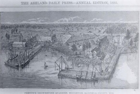
Portrait of Prentice’s brownstone quarries at Houghton Point.
~ Ashland Daily Press, circa 1893.
A Great Brownstone Industry Established At Houghton Point.
What Frederick Prentice Has Accomplished During The Season.“
~ Ashland Daily Press article in the Washburn Itemizer, October 18, 1888, reproduced on BattleAxCamp.tripod.com
One industry on Ashland bay is the brown stone, which exists along the water’s edge for many miles on the shore of the mainland and on the islands. It can be quarried in inexhaustible quantities within a few hundred feet of navigable waters of Lake Superior. It is of fine texture and beautiful color, and hardens by exposure. Large quantities have already been shipped and the demand is rapidly increasing. It can be shipped by rail at about four dollars per ton to Cincinnati. This stone, used for trimmings in buildings built of white brick, makes a very beautiful appearance.
The vast quantities of pine and hardwood timber in the vicinity of Ashland, and its advantages as a point of distribution for manufactured articles in wood, render it one of the best locations for manufacturing industries. For tanneries its location is unrivaled; the supply of hemlock bark is ample, while hides can be cheaply brought from Minnesota and the northwest, and the products can be shipped in all directions at low rates.
The schools of Ashland afford the best of opportunities for the education of our youth. Our school buildings are large, new and commodious, with all modern improvements. Our schools are graded and the attendance is large.
In the churches, most denominations are represented. The Catholic is the finest church edifice in the city, built of our own brown stone at a cost of over thirty thousand dollars. There are Presbyterian, Congregational, Episcopal, Baptist, Methodist, Lutheran and several Scandinavian churches.
As a summer resort, Ashland and the Apostles’ islands afford unrivaled attractions. Sail-boats, tugs and steamboats make daily excursions in all directions. They busy men from Chicago, St. Louis, St. Paul, Cincinnati and other cities can, in one day, escape from the sweltering heat and sleep on the cool ore of Lake Superior, and with our lines of railroad and telegraph stretching in all directons, they can be in constant and instant communication with their counting-rooms a thousand miles away. Its advantages in this line are already drawing many persons of wealth and leisure, as well as invalids, who come here to spend the hot season and at the close of the summer return home with new health and vigor.

Portrait of Edwin Ellis, M.D. on page 20.
Ashland has just two daily and three weekly newspapers, models of enterprise and very newsy, contributing much to the prosperity of the city.
The population of Ashland is about fifteen thousand, composed principally of persons under thirty-five years of age, and full of push and activity, who have come to stay and built up fortunes.
With all these and many other advantages Ashland seems to have a bright future, and many of us think it bids fair, in the near future, to become the second city in the state of Wisconsin. And we will labor that she shall be worthy of her rank.
EDWIN ELLIS.
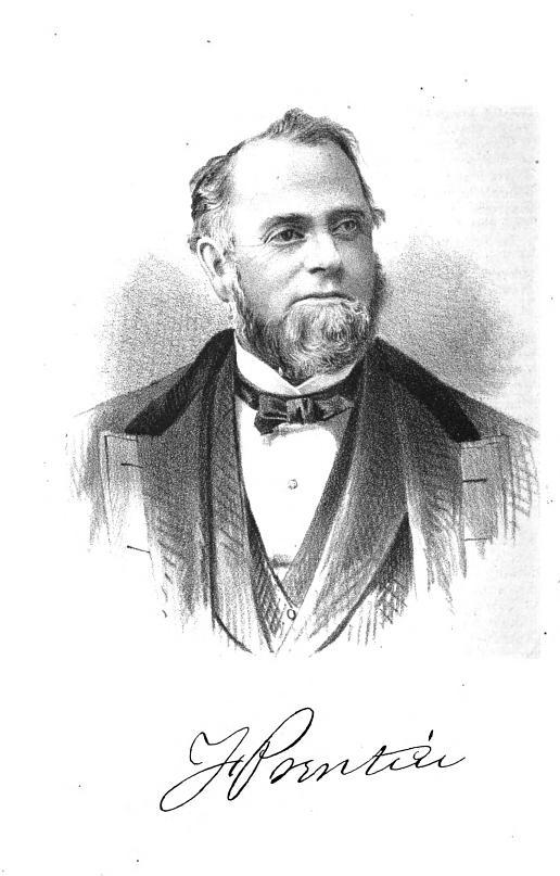
Martin Beaser
August 9, 2016
By Amorin Mello
Magazine of Western History Illustrated
November 1888
as republished in
Magazine of Western History: Volume IX, No.1, pages 24-27.
Martin Beaser.
Portrait of Martin Beaser on page 24.
On the fifth day of July 1854, Asaph Whittlesey and George Kilborn left La Pointe, in a row-boat, with the design of finding a “town site” on some available point near the “head of the bay.” At five o’clock P.M. of the same day they landed at the westerly limit of the present town site of Ashland. As Mr. Whittlesey stepped ashore, Mr. Kilborn exclaimed, “Here is the place for a big city!” and handing his companion an axe, he added, “I want you to have the honor of cutting the first tree in a way of a settlement upon the town site.” And the tree thus felled formed one of the foundation logs in the first building in the place. Such is the statement which has found its way into print as to the beginning of Ashland. But the same account adds: “Many new-comers arrived during the first few years after the settlement; among them Martin Beaser, who located permanently in Ashland in 1856, and was one of its founders.”1 How this was will soon be explained.
The father of the subject of this sketch, John Baptiste Beaser, was a native of Switzerland, educated as a priest, but never took orders. He came to America, reaching Philadelphia about the year 1812, where he married Margaret McLeod. They then moved to Buffalo, in one of the suburbs of which, called Williamsville, their son Martin was born, on the twenty-seventh of October, 1822. The boy received his early education in the common schools of the place, when, at the age of fourteen, he went on a whaling voyage, sailing from New Bedford, Massachusetts. His voyage lasted four years; his second voyage, three years; the last of which was made in the whaleship Rosseau, which is still afloat, the oldest of its class in America.
The young man went out as boat-steerer on his second voyage, returning as third mate. During his leisure time on shipboard and the interval between the two voyages, he spent in studying the science of navigation, which he successfully mastered. On his return from his fourth years’ cruise in the Pacific and Indian oceans, he was offered the position of second mate on a new ship then nearing completion and which would be ready to sail in about sixty days. He accepted the offer. They would notify him when the ship was ready, and he would in the meantime visit his mother, then a widow, residing in Buffalo. Accordingly, after an absence of seven years, he returned to his native city, spending the time in renewing old acquaintances and relating the varied experience of a whaler’s life. He had rare conversational powers, holding his listeners spell-bound at the recital of some thrilling adventure. A journal kept by him during his voyages and now in the possession of his family, abounds in hair-breadth escapes from savages on the shores of some of the South sea islands and the perils of whale-fishing, of which he had many narrow escapes. The time passed quickly, and he anxiously awaited the summons to join his ship. Leaving the city for a day the expected letter came, but was carefully concealed by his mother until after the ship had sailed, thus entirely changing the future of his life.
“… Martin, a sailor just from the whaling grounds of the Northwest Coast …”
Disappointed in his aspirations to command a ship in the near future, as he had reasons to hope from the rapid promotions he had already received – from a boy before the mast to mate of a ship in two voyages – and yielding to his mother’s wish not to leave home again, he engaged in sailing on Lake Erie from Buffalo to Detroit until 1847, when he went in the interest of a company in the latter city to Lake Superior for the purpose of exploring the copper ranges in the northern peninsula of Michigan. He coasted from Sault Ste. Marie to Ontonagon in a bateau. Remaining in the employ of the company about a year, he then engaged in a general forwarding and commission business for himself.
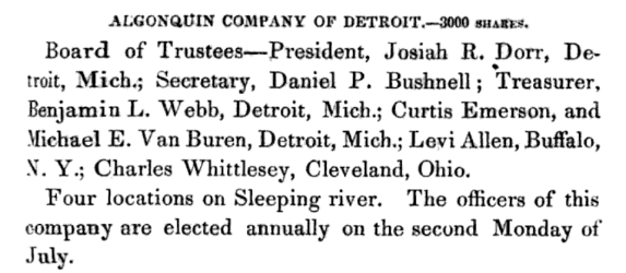
“Algonquin Company of Detroit.”
~ Reports of Wm. A. Burt and Bela Hubbard, by T. W. Bristol, 1846, page 97.
~ A History of the Northern Peninsula of Michigan and Its People: Volume 1, by Alvah Littlefield Sawyer, 1911, page 222.
Mr. Beaser was largely identified with the early mining interests of Ontonagon county, being instrumental in opening up and developing some of the best mines in that district.
In 1848 he was married in Cattaraugus county, New York, in the town of Perrysburgh, to Laura Antionette Bebee. The husband and wife the next spring went west, going to Ontonagon by way of Detroit. The trip from buffalo lasted from the first day of May to the sixth of June, they being detained at the “Soo” two weeks on account of the changing of the schooner Napoleon into a propeller, in which vessel, after a voyage of six days, they reached Ontonagon.
Here Mr. Beaser resided for seven years in the same business of forwarding and commission, furnishing frequently powder and candles to the miners by the ton. He was a portion of the this time associated with Thomas B. Hanna, formerly of Ohio. They then sold out their interest – Mr. Beaser going in company with Augustus Coburn and Edward Sayles to Superior, at the head of the lake, taking a small boat with them and Indian guides. Thus equipped they explored the region of Duluth, going up the Brule and St. Louis rivers. They then returned to La Pointe, going up Chaquamegon bay; and having their attention called to the site of what is now Ashland, on account of what seemed to be its favorable geographical position. As there had been some talk of the feasibility of connecting the Mississippi river and Lake Superior by a ship canal, it was suggested to them that this point would be a good one for its eastern terminus. Another circumstance which struck them was the contiguity of the Penokee iron range. This was in 1853. The company then returned to Ontonagon.
Closing up his business at the latter place, Mr. Beaser decided to return to the bay of Chaquamegon to look up and locate the town site on its southern shore. In the summer of 1854, on arriving there, he found Mr. Whittlesey and Mr. Kilborn on the ground. He then made arrangement with them by which he (Mr. Beaser) was to enter the land, which he did at Superior, where the land office was then located for that section. The contract between the three was, that Mr. Whittlesey and Mr. Kilborn were to receive each an eighth interest in the land, while the residue was to go to Mr. Beaser. The patent for the land was issued to Schuyler Goff, as county Judge of La Pointe county, Wisconsin, who was the trustee for the three men, under the law then governing the location of town sites.
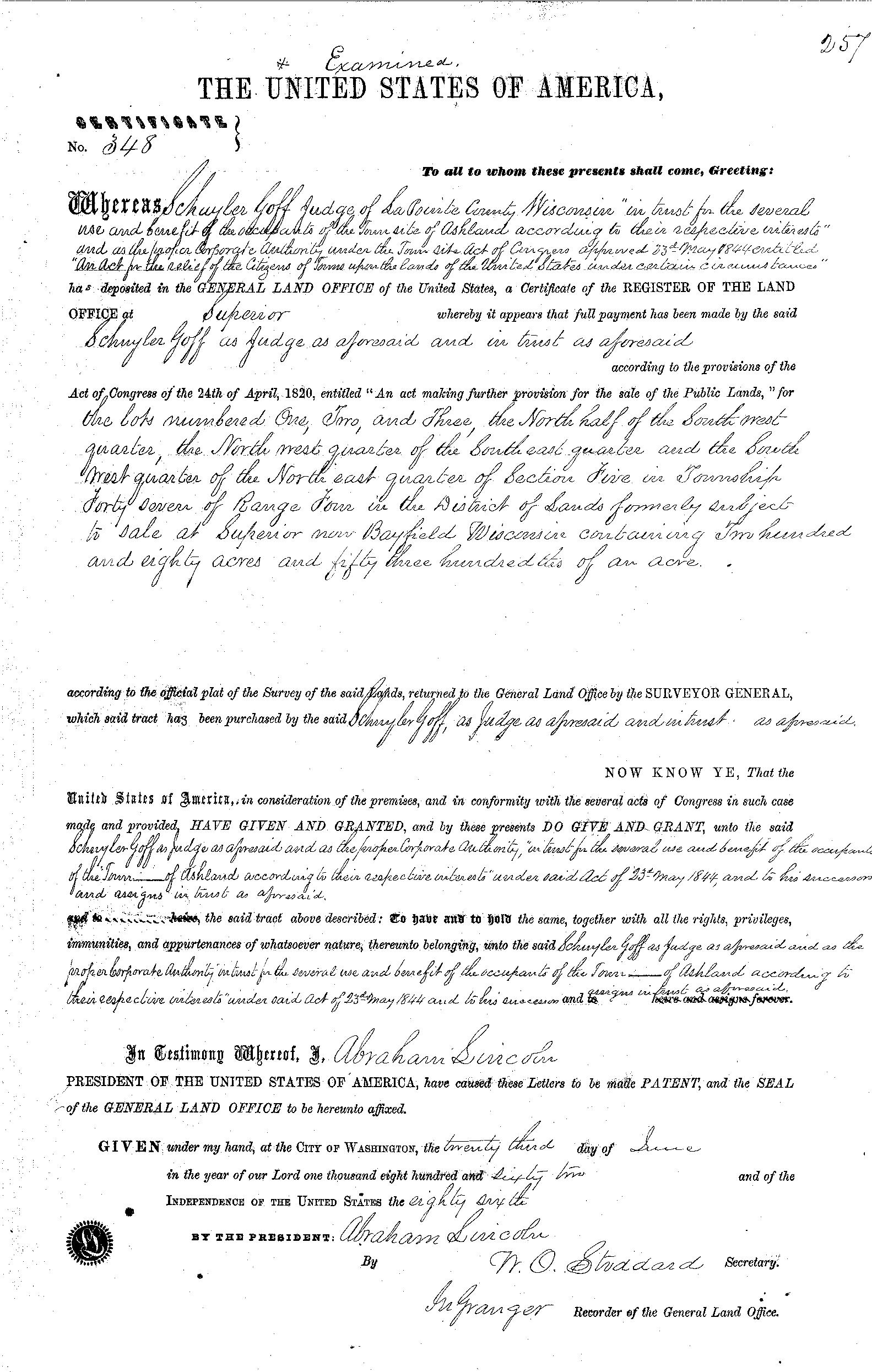
La Pointe County Judge Schuyler Goff was issued this patent for 280.53 acres on June 23rd, 1862, on behalf of Martin Beaser, Asaph Whittlesey, and George Kilburn.
~ General Land Office Records
Mr. Beaser afterwards got his deed from the judge to his three-quarters’ interest in the site.

Beaser named Ashland in honor of the Henry Clay Estate in Kentucky.
~ National Park Service
In January, 1854, Mr. Beaser having previously engaged a topographical engineer, G.L. Brunschweiler, the two, with a dog train and two Indians, made the journey from Ontonagon to the proposed town site, where Mr. Brunschweiler surveyed and platted2 a town on the land of the men before spoken of as parties in interest, to which town Mr. Beaser gave the name of Ashland. These three men, therefore, were the founders of Ashland, although afterwards various additions were made to it.
Mr. Beaser did not bring his family to Ashland until the eighth of September, 1856. He engaged in the mercantile business there until the war broke out, and was drowned in the bay while attempting to come from Bayfield to Ashland in an open boat, during a storm, on the fourth of November, 1866. He was buried on Madeline island at La Pointe. He was “closely identified with enterprises tending to open up the country; was wealthy and expended freely; was a man of fine discretion and good, common sense.” He was never discouraged as to Ashland’s future prosperity.
The children of Mr. Beaser, three in number, are all living: Margaret Elizabeth, wife of James A. Croser of Menominee, Michigan; Percy McLeod, now of Ashland; and Harry Hamlin, also of Ashland, residing with his mother, now Mrs. Wilson, an intelligent and very estimable lady.
1 See ‘History of Northern Wisconsin,’ p. 67.
2 The date of the platting of Ashland by Brunschweiler is taken from the original plat in the possession of the recorder of Ashland county, Wisconsin.
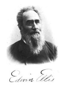
Edwin Ellis, M.D.
August 7, 2016
By Amorin Mello
Magazine of Western History Illustrated
November 1888
as republished in
Magazine of Western History: Volume IX, No.1, pages 21-24.
Edwin Ellis.
Portrait of Edwin Ellis, M.D. on page 20.
The subject of this sketch is a native of New England, and one of the “Oxford Bears,” having been in Peru, Oxford county, Maine, in 1824. His birthplace was on the banks of the Androscoggin river, among the mountains, a wild, romantic place. His ancestors came early from England to the Massachusetts colony, about the middle of the seventeenth century.
His maternal grandfather was in the Revolutionary army, and to the end of a long life was intensely patriotic and American in all his acts and thoughts. He bought one hundred and sixty acres of government land at the close of the War of the Revolution, on which he lived for more than seventy years, until his death. It still remains in the family. There were no roads in his neighborhood; and at first he was obliged to carry his corn and wheat to mill, for more than thirty miles, upon his shoulders and by a “spotted line.” He lived to break the ground for a railroad to his town and to see its completion.
Dr. Ellis received his early education in the New England common school, whose term was not more than three months in the year. At the age of fourteen years he began the study of Latin at home, going for occasional recitations to one of the celebrated Abbot family, who was a farmer in the town, some four miles distant. He was inclined to study the law, but his mother, who was a most conscientious woman, thought an honest lawyer could not live by his calling, often repeating to him this couplet –
“If I turn lawyer, I must lie and cheat,
For honest lawyers have no bread to eat.”
This had some influence upon him, and he chose the profession of medicine. He entered Waterville college (now Cobly university) in 1842, pursuing its first year’s course, when he began the study of medicine, teaching school in winter to raise money enough to pay his expenses, in which he was cheerfully assisted by his father to the extent of his means, which were very limited, he being a house carpenter and receiving the usual wages of those days of one dollar to one dollar and fifty cents per day.
Edwin Ellis graduated in medicine at the University of the city of New York, in March, 1846, being nearly twenty-two years of age. He at first settled at North New Portland, Maine. It was a frontier town, and the roads in such condition that he was obliged to travel on horseback, going sometimes forty miles in the night.
Brother-in-law Daniel A. J. Baker
~ The Eye of the North-west, pg. 9.
At the end of a year he settled in Farmington, Maine, where he had studied his profession, where, in 1847, he was married to Sophia S. Davis, who lived less than two years, leaving a daughter, Sophia Augusta, who married George H. Kennedy, who now lives at Ashland.
Dr. Ellis married Martha B. Baker of New Sharon, Maine, in 1850, a woman who has been a faithful and efficient wife for almost forty years. By her he has three children – Domelia, married to George C. Loranger of Calumet, Michigan; Edwin H., bookkeeper in the First National Bank of Ashland, and J. Scott, engaged in wood and coal at Ashland.
Dr. Ellis continued the practice of his profession in Maine, till 1854, with an increasing practice and fair prospects.
~ Minnesota Historical Society Collections: Volume XV, page 832.
But the west was then attracting much attention and the tide of emigration flowing with a strong current. His wife’s brother, Judge Baker of St. Paul, and been for several years in St. Paul, and his representations and inducements led him to sever his pleasant relations with the east and try his fortunes in the west. He with his family, wife and two children, reached St. Paul early in May, 1854. That year he carried on a farm where Merriam park now is, but he was not at home in this business, and abandoned it in the fall of that year.
The years 1852 to 1857 were years of great speculation throughout the northwest. Towns and cities, at least on paper, were springing up with marvelous rapidity. Men became, or seemed to become, suddenly rich by the rapid rise of farming lands and city lots. It was an era of strange speculation, demoralizing in its effects and leading to the terrible panic of 1857.
!["In 1845 [Warren Lewis] was appointed Register of the United States Land Office at Dubuque. In 1853 he was appointed by President Pierce Surveyor-General for Iowa, Wisconsin and Minnesota and at the expiration of his term was reappointed by President Buchanan." ~ The Iowa Legislature](https://chequamegonhistory.com/wp-content/uploads/2015/10/warner-lewis.jpg)
“In 1845 [Warren Lewis] was appointed Register of the United States Land Office at Dubuque. In 1853 he was appointed by President Pierce Surveyor-General for Iowa, Wisconsin and Minnesota and at the expiration of his term was reappointed by President Buchanan.”
~ The Iowa Legislature

Ellis was issued his title to 125.72 acres of land in Ashland on July 15th, 1858.
~ General Land Office Records

Downtown in Saint Paul during the financial panic of 1857.
~ Minnesota Historical Society
![Leonard Hemenway Wheeler ~ Unnamed Wisconsin by [????]](https://chequamegonhistory.com/wp-content/uploads/2016/03/leonard-hemenway-wheeler-from-unnamed-wisconsin.jpg)
Leonard Hemenway Wheeler
~ Unnamed Wisconsin, by John Nelson Davidson, 1895.
In 1877 he was appointed as county judge of Ashland county, by Governor Smith, to which he has been twice re-elected by his fellow-citizens. He is president of the First National Bank of Ashland. He has retired from the general practice of his profession, but is one of the surgeons of St. Joseph’s hospital, which he visits an hour each day. He is still active and deeply interested in all that concerns Ashland; has aided in securing the Holly system of water-works, the gas and electric works and the street railway. He is a firm believer in the Christian religion and in a personal God, whose guiding hand he recognizes in all the events of his life, and to whom he owes everything and to whom he desires to honor in all his journey of life, and is still alive to all efforts designed to improve and elevate the condition of his fellow-men.
Edwin Ellis, M.D., died in Ashland on May 3rd, 1903. This portrait and a posthumous biography of Dr. Ellis are available on pages 16-18 of Commemorative Biographical Record of the Upper Lake Region by J.H. Beers & Co., 1905.
Historic Sites on Chequamegon Bay
July 25, 2016
By Amorin Mello
Historical Sites on Chequamegon Bay was originally published in Collections of the State Historical Society of Wisconsin: Volume XIII, by Reuben Gold Thwaites, 1895, pages 426-440.
HISTORIC SITES ON CHEQUAMEGON BAY.1
—
BY CHRYSOSTOM VERWYST, O.S.F.
Reverend Chrysostome Verwyst, circa 1918.
~ Wisconsin Historical Society
One of the earliest spots in the Northwest trodden by the feet of white men was the shore of Chequamegon Bay. Chequamegon is a corrupt form of Jagawamikong;2 or, as it was written by Father Allouez in the Jesuit Relation for 1667, Chagaouamigong. The Chippewas on Lake Superior have always applied this name exclusively to Chequamegon Point, the long point of land at the entrance of Ashland Bay. It is now commonly called by whites, Long Island; of late years, the prevailing northeast winds have caused Lake Superior to make a break through this long, narrow peninsula, at its junction with the mainland, or south shore, so that it is in reality an island. On the northwestern extremity of this attenuated strip of land, stands the government light-house, marking the entrance of the bay.

William Whipple Warren, circa 1851.
~ Commons.Wikimedia.org
W. W. Warren, in his History of the Ojibway Nation3, relates an Indian legend to explain the origin of this name. Menabosho, the great Algonkin demi-god, who made this earth anew after the deluge, was once hunting for the great beaver in Lake Superior, which was then but a large beaver-pond. In order to escape his powerful enemy, the great beaver took refuge in Ashland Bay. To capture him, Menabosho built a large dam extending from the south shore of Lake Superior across to Madelaine (or La Pointe) Island. In doing so, he took up the mud from the bottom of the bay and occasionally would throw a fist-full into the lake, each handful forming an island, – hence the origin of the Apostle Islands. Thus did the ancient Indians, the “Gété-anishinabeg,” explain the origin of Chequamegon Point and the islands in the vicinity. His dam completed, Menabosho started in pursuit of the patriarch of all the beavers ; he thinks he has him cornered. But, alas, poor Menabosho is doomed to disappointment. The beaver breaks through the soft dam and escapes into Lake Superior. Thence the word chagaouamig, or shagawamik (“soft beaver-dam”), – in the locative case, shagawamikong (“at the soft beaver-dam”).
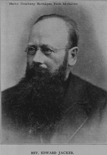
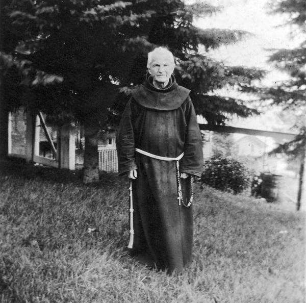
Reverend Edward Jacker
~ FindAGrave.com
Rev. Edward Jacker, a well-known Indian scholar, now deceased, suggests the following explanation of Chequamegon: The point in question was probably first named Jagawamika (pr. shagawamika), meaning “there are long, far-extending breakers;” the participle of this verb is jaiagawamikag (“where there are long breakers”). But later, the legend of the beaver hunt being applied to the spot, the people imagined the word amik (a beaver) to be a constituent part of the compound, and changed the ending in accordance with the rules of their language, – dropping the final a in jagawamika, making it jagawamik, – and used the locative case, ong (jagawamikong), instead of the participial form, ag (jaiagawamikag).4
The Jesuit Relations apply the Indian name to both the bay and the projection of land between Ashland Bay and Lake Superior. our Indians, however, apply it exclusively to this point at the entrance of Ashland Bay. It was formerly nearly connected with Madelaine (La Pointe) Island, so that old Indians claim a man might in early days shoot with a bow across the intervening channel. At present, the opening is about two miles wide. The shores of Chequamegon Bay have from time immemorial been the dwelling-place of numerous Indian tribes. The fishery was excellent in the bay and along the adjacent islands. The bay was convenient to some of the best hunting grounds of Northern Wisconsin and Minnesota. The present writer was informed, a few years ago, that in Douglas county alone 2,500 deer had been killed during one short hunting season.5 How abundant must have been the chase in olden times, before the white had introduced to this wilderness his far-reaching fire-arms! Along the shores of our bay were established at an early day fur-trading posts, where adventurous Frenchmen carried on a lucrative trade with their red brethren of the forest, being protected by French garrisons quartered in the French fort on Madelaine Island.
From Rev. Henry Blatchford, an octogenarian, and John B. Denomie (Denominé), an intelligent half-breed Indian of Odanah, near Ashland, the writer has obtained considerable information as to the location of ancient and modern aboriginal villages on the shores of Chequamegon Bay. Following are the Chippewa names of the rivers and creeks emptying into the bay, where there used formerly to be Indian villages:

Charles Whittlesey documented several pictographs along the Bad River.
Mashki-Sibi (Swamp River, misnamed Bad River): Up this river are pictured rocks, now mostly covered with earth, on which in former times Indians engraved in the soft stone the images of their dreams, or the likenesses of their tutelary manitous. Along this river are many maple-groves, where from time immemorial they have made maple-sugar.
Makodassonagani-Sibi (Bear-trap River), which emptties into the Kakagon. The latter seems in olden times to have been the regular channel of Bad River, when the Bad emptied into Ashland Bay, instead of Lake Superior, as it now does. Near the mouth of the Kakagon are large wild-rice fields, where the Chippewas annually gather, as no doubt did their ancestors, great quantities of wild rice (Manomin). By the way, wild rice is very palatable, and the writer and his dusky spiritual children prefer it to the rice of commerce, although it does not look quite so nice.
Bishigokwe-Sibiwishen is a small creek, about six miles or so east of Ashland. Bishigokwe means a woman who has been abandoned by her husband. In olden times, a French trader resided at the mouth of this creek. He suddenly disappeared, – whether murdered or not, is not known. His wife continued to reside for many years at their old home, hence the name.
Nedobikag-Sibiwishen is the Indian name for Bay City Creek, within the limits of Ashland. Here Tagwagané, a celebrated Indian chief of the Crane totem, used occasionally to reside. Warren6 gives us a speech of his, at the treaty of La Pointe in 1842. This Tagwagané had a copper plate, an heirloom handed down in his family from generation to generation, on which were rude indentations and hieroglyphics denoting the number of generations of that family which had passed away since they first pitched their lodges at Shagawamikong and took possession of the adjacent country, including Madelaine Island. From this original mode of reckoning time, Warren concludes that the ancestors of said family first came to La Pointe circa A. D. 1490.

Detail of “Ici était une bourgade considerable” from Carte des lacs du Canada by Jacques-Nicolas Bellin, 1744.
~ Wisconsin Historical Society
Metabikitigweiag-Sibiwishen is the creek between Ashland and Ashland Junction, which runs into Fish Creek a short distance west of Ashland. At the junction of these two creeks and along their banks, especially on the east bank of Fish Creek, was once a large and populous Indian village of Ottawas, who there raised Indian corn. It is pointed out on N. Bellin’s map (1744)7, with the remark, Ici était une bourgade considerable (“here was once a considerable village”). We shall hereafter have occasion to speak of this place. The soil along Fish Creek is rich, formed by the annual overflowage of its water, leaving behind a deposit of rich, sand loam. There a young growth of timber along the right bank between the bay and Ashland Junction, and the grass growing underneath the trees shows that it was once a cultivated clearing. It was from this place that the trail left the bay, leading to the Chippewa River country. Fish Creek is called by the Indians Wikwedo-Sibiwishen, which means “Bay Creek,” from wikwed, Chippewa for bay; hence the name Wikwedong, the name they gave to Ashland, meaning “at the bay.”
Whittlesey Creek (National Wildlife Refuge) was named after Asaph Whittlesey, brother of Charles Whittlesey. Photo of Asaph, circa 1860.
~ Wisconsin Historical Society
According to Blatchford, there was formerly another considerable village at the mouth of Whittlesey’s Creek, called by the Indians Agami-Wikwedo-Sibiwishen, which signifies “a creek on the other side of the bay,” from agaming (on the other side of a river, or lake), wikwed (a bay), and sibiwishen (a creek). I think that Fathers Allouez and Marquette had their ordinary abode at or near this place, although Allouez seems also to have resided for some time at the Ottawa village up Fish Creek.
A short distance from Whittlesey’s Creek, at the western bend of the bay, where is now Shore’s Landing, there used to be a large Indian village and trading-post, kept by a Frenchman. Being at the head of the bay, it was the starting point of the Indian trail to the St. Croix country. Some years ago the writer dug up there, an Indian mound. The young growth of timber at the bend of the bay, and the absence of stumps, indicate that it had once been cleared. At the foot of the bluff or bank, is a beautiful spring of fresh water. As the St. Croix country was one of the principal hunting grounds of the Chippewas and Sioux, it is natural there should always be many living at the terminus of the trail, where it struck the bay.
From this place northward, there were Indian hamlets strung along the western shore of the bay. Father Allouez mentions visiting various hamlets two, three, or more (French) leagues away from his chapel. Marquette mentions five clearings, where Indian villages were located. At Wyman’s place, the writer some years ago dug up two Indian mounds, one of which was located on the very bank of the bay and was covered with a large number of boulders, taken from the bed of the bay. In this mound were found a piece of milled copper, some old-fashioned hand-made iron nails, the stem of a clay pipe, etc. The objects were no doubt relics of white men, although Indians had built the mound itself, which seemed like a fire-place shoveled under, and covered with large boulders to prevent it from being desecrated.
Boyd’s Creek is called in Chippewa, Namebinikanensi-Sibiwishen, meaning “Little Sucker Creek.” A man named Boyd once resided there, married to an Indian woman. He was shot in a quarrel with another man. One of his sons resides at Spider Lake, and another at Flambeau Farm, while two of his grand-daughters live at Lac du Flambeau.
Further north is Kitchi-Namebinikani-Sibiwishen, meaning “Large Sucker Creek,” but whites now call it Bonos Creek. These two creeks are not far apart, and once there was a village of Indians there. It was noted as a place for fishing at a certain season of the year, probably in spring, when suckers and other fish would go up these creeks to spawn.
At Vanderventer’s Creek, near Washburn, was the celebrated Gigito-Mikana, or “council-trail,” so called because here the Chippewas once held a celebrated council; hence the Indian name Gigito-Mikana-Sibiwishen, meaning “Council-trail Creek.” At the mouth of this creek, there was once a large Indian village.
There used also to be a considerable village between Pike’s Bay and Bayfield. It was probably there that the celebrated war chief, Waboujig, resided.

John Baptiste Denomie
~ Noble Lives of a Noble Race, A Series of Reproductions by the Pupils of Saint Mary’s, Odanah, Wisconsin, page 213-217.
There was once an Indian village where Bayfield now stands, also at Wikweiag (Buffalo Bay), at Passabikang, Red Cliff, and on Madelaine Island. The writer was informed by John B. Denomie, who was born on the island in 1834, that towards Chabomnicon Bay (meaning “Gooseberry Bay”) could long ago be seen small mounds or corn-hills, now overgrown with large trees, indications of early Indian agriculture. There must have been a village there in olden times. Another ancient village was located on the southwestern extremity of Madelaine Island, facing Chequamegon Point, where some of their graves may still be seen. It is also highly probable that there were Indian hamlets scattered along the shore between Bayfield and Red Cliff, the most northern mainland of Wisconsin. There is now a large, flourishing Indian settlement there, forming the Red Cliff Chippewa reservation. There is a combination church and school there at present, under the charge of the Franciscan Order. Many Indians also used to live on Chequamegon Point, during a great part of the year, as the fishing was good there, and blueberries were abundant in their season. No doubt from time immemorial Indians were wont to gather wild rice at the mouth of the Kakagon, and to make maple sugar up Bad River.

Illustration from The Story of Chequamegon Bay, Collections of the State Historical Society of Wisconsin: Volume XIII, 1895, page 419.
We thus see that the Jesuit Relations are correct when they speak of many large and small Indian villages (Fr. bourgades) along the shores of Chequamegon Bay. Father Allouez mentions two large Indian villages at the head of the bay – the one an Ottawa village, on Fish Creek; the other a Huron, probably between Shore’s Landing and Washburn. Besides, he mentions smaller hamlets visited by him on his sick-calls. Marquette says that the Indians lived there in five clearings, or villages. From all this we see that the bay was from most ancient times the seat of a large aboriginal population. Its geographical position towards the western end of the great lake, its rich fisheries and hunting grounds, all tended to make it the home of thousands of Indians. Hence it is much spoken of by Perrot, in his Mémoire, and by most writers on the Northwest of the last century. Chequamegon Bay, Ontonagon, Keweenaw Bay, and Sault Ste. Marie (Baweting) were the principal resorts of the Chippewa Indians and their allies, on the south shore of Lake Superior.
“Front view of the Radisson cabin, the first house built by a white man in Wisconsin. It was built between 1650 and 1660 on Chequamegon Bay, in the vicinity of Ashland. This drawing is not necessarily historically accurate.”
~ Wisconsin Historical Society
The first white men on the shores of Chequamegon Bay were in all probability Groseilliers and Radisson. They built a fort on Houghton Point, and another at the head of the bay, somewhere between Whittlesey’s Creek and Shore’s Landing, as in some later paper I hope to show from Radisson’s narrative.8 As to the place where he shot the bustards, a creek which led him to a meadow9, I think this was Fish Creek, at the mouth of which is a large meadow, or swamp.10
After spending six weeks in the Sioux country, our explorers retraced their steps to Chequamegon Bay, arriving there towards the end of winter. They built a fort on Houghton Point. The Ottawas had built another fort somewhere on Chequamegon Point. In travelling towards this Ottawa fort, on the half-rotten ice, Radisson gave out and was very sick for eight days; but by rubbing his legs with hot bear’s oil, and keeping them well bandaged, he finally recovered. After his convalescence, our explorers traveled northward, finally reaching James Bay.
The next white men to visit our bay were two Frenchmen, of whom W. W. Warren says:11
“One clear morning in the early part of winter, soon after the islands which are clustered in this portion of Lake Superior, and known as the Apostles, had been locked in ice, a party of young men of the Ojibways started out from their village in the Bay of Shag-a-waum-ik-ong [Chequamegon], to go, as was customary, and spear fish through holes in the ice, between the island of La Pointe and the main shore, this being considered as the best ground for this mode of fishing. While engaged in this sport, they discovered a smoke arising from a point of the adjacent island, toward its eastern extremity.
“The island of La Pointe was then totally unfrequented, from superstitious fears which had but a short time previous led to its total evacuation by the tribe, and it was considered an act of the greatest hardihood for any one to set foot on its shores. The young men returned home at evening and reported the smoke which they had seen arising from the island, and various were the conjectures of the old people respecting the persons who would dare to build a fire on the spirit-haunted isle. They must be strangers, and the young men were directed, should they again see the smoke, to go and find out who made it.
“Early the next morning, again proceeding to their fishing-ground, the young men once more noticed the smoke arising from the eastern end of the unfrequented island, and, again led on by curiosity, they ran thither and found a small log cabin, in which they discovered two white men in the last stages of starvation. The young Ojibways, filled with compassion, carefully conveyed them to their village, where being nourished with great kindness, their lives were preserved.
“These two white men had started from Quebec during the summer with a supply of goods, to go and find the Ojibways who every year had brought rich packs of beaver to the sea-coast, notwithstanding that their road was barred by numerous parties of the watchful and jealous Iroquois. Coasting slowly up the southern shores of the Great Lake late in the fall, they had been driven by the ice on to the unfrequented island, and not discovering the vicinity of the Indian village, they had been for some time enduring the pangs of hunger. At the time they were found by the young Indians, they had been reduced to the extremity of roasting and eating their woolen cloth and blankets as the last means of sustaining life.
“Having come provided with goods they remained in the village during the winter, exchanging their commodities for beaver skins. They ensuing spring a large number of the Ojibways accompanied them on their return home.
“From close inquiry, and judging from events which are said to have occurred about this period of time, I am disposed to believe that this first visit by the whites took place about two hundred years ago [Warren wrote in 1852]. It is, at any rate, certain that it happened a few years prior to the visit of the ‘Black-gowns’ [Jesuits] mentioned in Bancroft’s History, and it is one hundred and eighty-four years since this well-authenticated occurrence.”
So far Warren; he is, however, mistaken as to the date of the first black-gown’s visit, which was not 1668 but 1665.

Portrayal of Claude Allouez
~ National Park Service
The next visitors to Chequamegon Bay were Père Claude Allouez and his six companions in 1665. We come now to a most interesting chapter in the history of our bay, the first formal preaching of the Christian religion on its shores. For a full account of Father Allouez’s labors here, the reader is referred to the writer’s Missionary Labors of Fathers Marquette, Allouez, and Ménard in the Lake Superior Region. Here will be given merely a succinct account of their work on the shores of the bay. To the writer it has always been a soul-inspiring thought that he is allowed to tread in the footsteps of those saintly men, who walked, over two hundred years ago, the same ground on which he now travels; and to labor among the same race for which they, in starvation and hardship, suffered so much.
In the Jesuit Relation for 1667, Father Allouez thus begins the account of his five years’ labors on the shores of our bay:
“On the eight of August of the year 1665, I embarked at Three Rivers with six Frenchmen, in company with more than four hundred Indians of different tribes, who were returning to their country, having concluded the little traffic for which they had come.”
Marquis Alexandre de Prouville de Tracy
~ Wikipedia.org
His voyage into the Northwest was one of the great hardships and privations. The Indians willingly took along his French lay companions, but him they disliked. Although M. Tracy, the governor of Quebec, had made Father Allouez his ambassador to the Upper Algonquins, thus to facilitate his reception in their country, nevertheless they opposed him accompanying them, and threatened to abandon him on some desolate island. No doubt the medicine-men were the principal instigators of this opposition. He was usually obliged to paddle like the rest, often till late in the night, and that frequently without anything to eat all day.
“On a certain morning,” he says, “a deer was found, dead since four or five days. It was a lucky acquisition for poor famished beings. I was offered some, and although the bad smell hindered some from eating it, hunger made me take my share. But I had in consequence an offensive odor in my mouth until the next day. In addition to all these miseries we met with, at the rapids I used to carry packs as large as possible for my strength; but I often succumbed, and this gave our Indians occasion to laugh at me. They used to make fun of me, saying a child ought to be called to carry me and my baggage.”
August 24, they arrived at Lake Huron, where they made a short stay; then coasting along the shores of that lake, they arrived at Sault Ste. Marie towards the beginning of September. September 2, they entered Lake Superior, which the Father named Lake Tracy in acknowledgement of the obligations which the people of those upper countries owed to the governor. Speaking of his voyage on Lake Superior, Father Allouez remarks:
“Having entered Lake Tracy, we were engaged the whole month of September in coasting along the south shore. I had the consolation of saying holy mass, as I now found myself alone with our Frenchmen, which I had not been able to do since my departure from Three Rivers. * * * We afterwards passed the bay, called by the aged, venerable Father Ménard, Sait Theresa [Keweenaw] Bay.”
Speaking of his arrival at Chequamegon Bay, he says:
“After having traveled a hundred and eighty leagues on the south shore of Lake Tracy, during which our Saviour often deigned to try our patience by storms, hunger, daily and nightly fatigues, we finally, on the first day of October, 1665, arrived at Chagaouamigong, for which place we had sighed so long. It is a beautiful bay, at the head of which is situated the large village of the Indians, who there cultivate fields of Indian corn and do not lead a nomadic life. There are at this place men bearing arms, who number about eight hundred; but these are gathered together from seven different tribes, and live in peacable community. This great number of people induced us to prefer this place to all others for our ordinary abode, in order to attend more conveniently to the instruction of these heathens, to put up a chapel there and commence the functions of Christianity.”
Further on, speaking of the site of his mission and its chapel, he remarks:
“The section of the lake shore, where we have settled down, is between two large villages, and is, as it were, the center of all the tribes of these countries, because the fishing here is very good, which is the principal source of support of these people.”
To locate still more precisely the exact site of his chapel, he remarks, speaking of the three Ottawa clans (Outaouacs, Kiskakoumacs, and Outaoua-Sinagonc):
“I join these tribes [that is, speaks of them as one tribe] because they had one and the same language, which is the Algonquin, and compose one of the same village, which is opposite that of the Tionnontatcheronons [Hurons of the Petun tribe] between which villages we reside.”
But where was that Ottawa village? A casual remark of Allouez, when speaking of the copper mines of Lake Superior, will help us locate it.
“It is true,” says he, “on the mainland, at the place where the Outaouacs raise Indian corn, about half a league from the edge of the water, the women have sometimes found pieces of copper scattered here and there, weighing ten, twenty or thirty pounds. It is when digging into the sand to conceal their corn that they make these discoveries.”
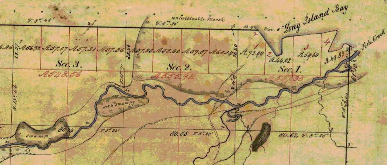
Detail of Fish Creek from Township 47 North Range 5 West.
~ Wisconsin Public Land Survey Records
Allouez evidently means Fish Creek. About a mile or so from the shore of the bay, going up this creek, can be seen traces of an ancient clearing on the left-hand side, where Metabikitigweiag Creeek empties into Fish Creek, about half-way between Ashland and Ashland Junction. The writer examined the locality about ten years ago. This then is the place where the Ottawas raised Indian corn and had their village. In Charlevoix’s History of New France, the same place is marked as the site of an ancient large village. The Ottawa village on Fish Creek appears to have been the larger of the two at the head of Chequamegon Bay, and it was there Allouez resided for a time, until he was obliged to return to his ordinary dwelling place, “three-fourths of a league distant.” This shows that the ordinary abode of Father Allouez and Marquette, the site of their chapel, was somewhere near Whittlesey’s Creek or Shore’s Landing. The Huron village was most probably along the western shore of the bay, between Shore’s Landing and Washburn.

Detail of Ashland next to an ancient large village (unmarked) in Township 47 North Range 4 West.
~ Wisconsin Public Land Survey Records
Father Allouez did not confine his apostolic labors to the two large village at the head of the bay. He traveled all over the neighborhood, visiting the various shore hamlets, and he also spent a month at the western extremity of Lake Superior – probably at Fond du Lac – where he met with some Chippewas and Sioux. In 1667 he crossed the lake, most probably from Sand Island, in a frail birch canoe, and visited some Nipissirinien Christians at Lake Nepigon (Allimibigong). The same year he went to Quebec with an Indian flotilla, and arrived there on the 3d of August, 1667. After only two days’ rest he returned with the same flotilla to his far distant mission on Chequamegon Bay, taking along Father Louis Nicholas. Allouez contained his missionary labors here until 1669, when he left to found St. Francis Xavier mission at the head of Green Bay. His successor at Chequamegon Bay was Father James Marquette, discoverer and explorer of the Mississippi. Marquette arrived here September 13, 1669, and labored until the spring of 1671, when he was obliged to leave on account of the war which had broken out the year before, between the Algonquin Indians at Chequamegon Bay and their western neighbors, the Sioux.
1 – See ante, p. 419 for map of the bay. – ED.
2 – In writing Indian names, I follow Baraga’s system of orthography, giving the French quality to both consonants and vowels.
3 – Minn. Hist. Colls., v. – ED.
4 – See ante, p. 399, note. – ED.
5 – See Carr’s interesting and exhaustive article, “The Food of Certain American Indians,” in Amer. Antiq. Proc., x., pp. 155 et seq. – ED.
6 – Minn. Hist. Colls., v. – ED.
7 – In Charlevoix’s Nouvelle France. – ED.
8 – See Radisson’s Journal, in Wis. Hist. Colls., xi. Radisson and Groseilliers reached Chequamegon Bay late in the autumn of 1661. – ED.
9 – Ibid., p. 73: “I went to the wood some 3 or 4 miles. I find a small brooke, where I walked by ye sid awhile, wch brought me into meddowes. There was a poole, where weare a good store of bustards.” – ED.
10 – Ex-Lieut. Gov. Sam. S. Fifield, of Ashland, writes me as follows:
“After re-reading Radisson’s voyage to Bay Chewamegon, I am satisfied that it would by his description be impossible to locate the exact spot of his camp. The stream in which he found the “pools,” and where he shot fowl, is no doubt Fish Creek, emptying into the bay at its western extremity. Radisson’s fort must have been near the head of the bay, on the west shore, probably at or near Boyd’s Creek, as there is an outcropping of rock in that vicinity, and the banks are somewhat higher than at the head of the bay, where the bottom lands are low and swampy, forming excellent “duck ground” even to this day. Fish Creek has three outlets into the bay, – one on the east shore or near the east side, one central, and one near the western shore; for full two miles up the stream, it is a vast swamp, through which the stream flows in deep, sluggish lagoons. Here, in the early days of American settlement, large brook trout were plenty; and even in my day many fine specimens have been taken from these “pools.” Originally, there was along these bottoms a heavy elm forest, mixed with cedar and black ash, but it has now mostly disappeared. An old “second growth,” along the east side, near Prentice Park, was evidently once the site of an Indian settlement, probably of the 18th century.
“I am of the opinion that the location of Allouez’s mission was at the mouth of Vanderventer’s Creek, on the west shore of the bay, near the present village of Washburn. It was undoubtedly once the site of a large Indian village, as was the western part of the present city of Ashland. When I came to this locality, nearly a quarter of a century ago, “second growth” spots could be seen in several places, where it was evident that the Indians had once had clearings for their homes. The march of civilization has obliterated these landmarks of the fur-trading days, when the old French voyageurs made the forest-clad shores of our beautiful bay echo with their boat songs, and when resting from their labors sparked the dusky maidens in their wigwams.”
Rev. E. P. Wheeler, of Ashland, a native of Madelaine Island, and an authority on the region, writes me:
“I think Radisson’s fort was at the mouth of Boyd’s Creek, – at least that place seems for the present to fulfill the conditions of his account. it is about three or four miles from here to Fish Creek valley, which leads, when followed down stream, to marshes ‘meadows, and a pool.’ No other stream seems to have the combination as described. Boyd’s Creek is about four miles from the route he probably took, which would be by way of the plateau back from the first level, near the lake. Radisson evidently followed Fish Creek down towards the lake, before reaching the marshes. This condition is met by the formation of the creek, as it is some distance from the plateau through which Fish Creek flows to its marshy expanse. Only one thing makes me hesitate about coming to a final decision, – that is, the question of the age of the lowlands and formations around Whittlesey Creek. I am going to go over the ground with an expert geologist, and will report later. Thus far, there seems to be no reason to doubt that Fish Creek is the one upon which Radisson hunted.” – ED.
11 – Minn. Hist. Colls., v., pp. 121, 122, gives the date as 1652. – ED.
Colonel Charles Whittlesey
May 27, 2016
By Amorin Mello

C.C. Baldwin was a friend, colleague, and biographer of Charles Whittlesey.
~ Memorial of Charles Candee Baldwin, LL. D.: Late President of the Western Reserve Historical Society, 1896, page iii.
This is a reproduction of Colonel Charles Whittlesey’s biography from the Magazine of Western History, Volume V, pages 534-548, as published by his successor Charles Candee Baldwin from the Western Reserve Historical Society. This biography provides extensive and intimate details about the life and profession of Whittlesey not available in other accounts about this legendary man.
Whittlesey came to Lake Superior in 1845 while working for the Algonquin Mining Company along the Keweenaw Peninsula’s copper region. His first trip to Chequamegon Bay appears to have been in 1849 while doing do a geological survey of the Penokee Mountains for David Dale Owen. Whittlesey played a dramatic role in American settlement of the Chequamegon Bay region. Whittlesey convinced his brother, Asaph Whittlesey Jr., to move from the Western Reserve in 1854 establish what became the City of Ashland at the head of Chequamegon Bay as a future port town for extracting and shipping minerals from the Penokee Mountains. Whittlesey’s influence can still be witnessed to this day through local landmarks named in his honor:
Whittlesey published more than two hundred books, pamphlets, and articles. For additional research resources, the extensive Charles Whittlesey Papers are available through the Western Reserve Historical Society in two series:
Magazine of Western History, Volume V, pages 534-548.
COLONEL CHARLES WHITTLESEY.

Map of the Connecticut Western Reserve in Ohio by William Sumner, September 1826.
~ Cleveland Public Library
![Asaph Whittlesey [Sr], Late of Tallmadge, Summit Co., Ohio by Vesta Hart Whittlesey and Susan Everett Whittlesey, né Fitch, 1872.](https://chequamegonhistory.com/wp-content/uploads/2016/05/asaph-whittlesey-vesta-hart.jpg)
[Father] Asaph Whittlesey [Sr], Late of Tallmadge, Summit Co., Ohio by [mother] Vesta Hart Whittlesey [posthumously] and [stepmother] Susan Everett Whittlesey, né Fitch, 1872.
~ Archive.org
War was then in the west, and his neighbors feared they might be the victims of the scalping knife. But the danger was different. In passing the Narrows, between Pittsburgh and Beaver, the wagon ran off a bank and turned completely over on the wife and children. They were rescued and revived, but the accident permanently impaired the health of Mr. Whittlesey.
Mr. Whittlesey was in Tallmadge, justice of the peace from soon after his arrival till near the close of his life, and postmaster from 1814, when the office was first established, to his death. He was again severely injured, but a strong constitution and unflinching will enabled him to accomplish much. He had a store, buying goods in Pittsburgh and bringing them in wagons to Tallmadge; and an ashery; and in 1818 he commenced the manufacture of iron on the Little Cuyahoga, below Middlebury.
The times were hard, tariff reduced, and in 1828 he returned to his farm prematurely old. He died in 1842. Says General Bierce,
“His intellect was naturally of a high order, his religious convictions were strong and never yielded to policy or expediency. He was plain in speech, sometimes abrupt. Those who respected him were more numerous than those who loved him. But for his friends, no one had a stronger attachment. His dislikes were not very well concealed or easily removed. In short, he was a man of strong mind, strong feelings, strong prejudices, strong affections and strong attachments, yet the whole was tempered with a strong sense of justice and strong religious feelings.”
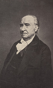
[Uncle] Elisha Whittlesey
~ Collection of the U.S. House of Representatives

Portrait of Reverend David Bacon from ConnecticutHistory.org:
“David Bacon (1771 – August 27, 1817) was an American missionary in Michigan Territory. He was born in Woodstock, Connecticut. He worked primarily with the Ottawa and Chippewa tribes, although they were not particularly receptive to his Christian teachings. He founded the town of Tallmadge, Ohio, which later became the center of the Congregationalist faith in Ohio.”
~ Wikipedia.org
Tallmadge was settled in 1808 as a religious colony of New England Congregationalists, by a colony led by Rev. David Bacon, a missionary to the Indians. This affected the society in which the boy lived, and exercised much influence on the morality of the town and the future of its children, one of whom was the Rev. Leonard Bacon. Rev. Timlow’s History of Southington says, “Mr. Whittlesey moved to Tallmadge, having become interested in settling a portion of Portage county with Christian families.” And that he was a man “of surpassing excellence of character.”
If it should seem that I have dwelt upon the parents of Colonel Whittlesey, it is because his own character and career were strongly affected by their characters and history. Charles, the son, combined the traits of the two. He commenced school at four years old in Southington; the next year he attended the log school house at Tallmadge until 1819, when the frame academy was finished and he attended it in winter, working on the farm in summer until he was nineteen.
The boy, too, saw early life on foot, horseback and with ox-teams. He found the Indians still on the Reserve, and in person witnessed the change from savage life and new settlements, to a state of three millions of people, and a large city around him. One of Colonel Whittlesey’s happiest speeches is a sketch of log cabin times in Tallmadge, delivered at the semi-centennial there in 1857.
~ Annual Report on the Geological Survey of the State of Ohio: 1837 by Ohio Geologist William Williams Mather, 1838, page 22.
In 1827 the youngster became a cadet at West Point. Here he displayed industry, and in some unusual incidents there, coolness and courage. He graduated in 1831, and became brevet second lieutenant in the Fifth United States infantry, and in November started to join his regiment at Mackinaw. He did duty through the winter with the garrison at Fort Gratiot. In the spring he was assigned at Green Bay to the company of Captain Martin Scott, so famous as a shot. At the close of the Black Hawk War he resigned from the army. Though recognizing the claim of the country to the services of the graduates of West Point, he tendered his services to the government during the Seminole Mexican war. By a varied experience his life thereafter was given to wide and general uses. He at first opened a law office in Cleveland, Ohio, and was fully occupied in his profession, and as part owner and co-editor of the Whig and Herald until the year 1837. He was that year appointed assistant geologist of the state of Ohio. Through very uneconomical economy, the survey was discontinued at the end of two years, when the work was partly done and no final reports had been made. Of course most of the work and its results were lost. Great and permanent good indeed resulted to the material wealth of the state, in disclosing the rich coal and iron deposit of southeastern Ohio, thus laying the foundation for the vast manufacturing industries which have made that portion of the state populous and prosperous. The other gentlemen associated with him were Professor William Mather as principal; Dr. Kirtland was entrusted with natural history. Others were Dr. S. P. Hildreth, Dr. Caleb Briggs, Jr., Professor John Locke and Dr. J. W. Foster. It was an able corps, and the final results would have been very valuable and accurate. In 1884, Colonel Whittlesey was sole survivor and said in this Magazine:
“Fifty years since, geology had barely obtained a standing among the sciences even in Europe. In Ohio it was scarcely recognized. The state at that time was more of a wilderness than a cultivated country, and the survey was in progress little more than two years. It was unexpectedly brought to a close without a final report. No provision was made for the preservation of papers, field notes and maps.”
Report of Progress in 1869, by J. S. Newberry, Chief Geologist, by the Geological Survey of Ohio, 1870.
Professor Newbury, in a brief resume of the work of the first survey (report of 1869), says the benefits derived “conclusively demonstrate that the geological survey was a producer and not a consumer, that it added far more than it took from the public treasury and deserved special encouragement and support as a wealth producing agency in our darkest financial hour.” The publication of the first board, “did much,” says Professor Newberry, “to arrest useless expenditure of money in the search for coal outside of the coal fields and in other mining enterprises equally fallacious, by which, through ignorance of the teachings of geology, parties were constantly led to squander their means.” “It is scarcely less important to let our people know what we have not, than what we have, among our mineral resources.”

“Descriptions of Ancient Works in Ohio. By Charles Whittlesey, of the late Geological Corps of Ohio.”
~ Smithsonian Contributions to Knowledge, Volume III., Article 7, 1852.
The topographical and mathematical parts of the survey were committed to Colonel Whittlesey. He made partial reports, to be found in the ‘State Documents’ of 1838 and 1839, but his knowledge acquired in the survey was of vastly greater service in many subsequent writings, and, as a foundation for learning, made useful in many business enterprises of Ohio. He had, during this survey, examined and surveyed many ancient works in the state, and, at its close, Mr. Joseph Sullivant, a wealthy gentleman interested in archaeology, residing in Columbus, proposed that, he bearing the actual expense, Whittlesey should continue the survey of the works of the Mound Builders, with a view to joint publication. During the years 1839 and 1840, and under the arrangement, he made examination of nearly all the remaining works then discovered, but nothing was done toward their publication. Many of his plans and notes were used by Messrs. Squier & Davis, in 1845 and 1846, in their great work, which was the first volume of the Smithsonian Contributions, and in that work these gentlemen said:
“Among the most zealous investigators in the field of American antiquarian research is Charles Whittlesey, esq., of Cleveland, formerly topographical engineer of Ohio. His surveys and observations, carried on for many years and over a wide field, have been both numerous and accurate, and are among the most valuable in all respects of any hitherto made. Although Mr. Whittlesey, in conjunction with Joseph Sullivant, esq., of Columbus, originally contemplated a joint work, in which the results of his investigations should be embodied, he has, nevertheless, with a liberality which will be not less appreciated by the public than by the authors, contributed to this memoir about twenty plans of ancient works, which, with the accompanying explanations and general observations, will be found embodied in the following pages.
“It is to be hoped the public may be put in possession of the entire results of Mr. Whittlesey’s labor, which could not fail of adding greatly to our stock of knowledge on this interesting subject.”

“Marietta Works, Ohio. Charles Whittlesey, Surveyor 1837.”
~ Smithsonian Contributions to Knowledge, Volume I., Plate XXVI.
It will be seen that Mr. Whittlesey was now fairly started, interested and intelligent, in the several fields which he was to make his own. And his very numerous writings may be fairly divided into geology, archaeology, history, religion, with an occasional study of topographical geology. A part of Colonel Whittlesey’s surveys were published in 1850, as one of the Smithsonian contributions; portions of the plans and minutes were unfortunately lost. Fortunately the finest and largest works surveyed by him were published. Among those in the work of Squier & Davis, were the wonderful extensive works at Newark, and those at Marietta. No one again could see those works extending over areas of twelve and fifteen miles, as he did. Farmers cannot raise crops without plows, and the geography of the works at Newark must still be learned from the work of Colonel Whittlesey.
~ Smithsonian Contributions to Knowledge, Volume XIII., Article IV., page 2 of “Ancient Mining on the Shores of Lake Superior” by Charles Whittlesey.
He made an agricultural survey of Hamilton county in 1844. That year the copper mines of Michigan began to excite enthusiasm. The next year a company was organized in Detroit, of which Colonel Whittlesey was the geologist. In August they launched their boat above the rapids of the Sault St. Marie and coasted along the shore to where is now Marquette. Iron ore was beneath notice, and in truth was no then transportable, and they pulled away for Copper Harbor, and then to the region between Portage lake and Ontonagon, where the Algonquin and Douglas Houghton mines were opened. The party narrowly escaped drowning the night they landed. Dr. Houghton was drowned the same night not far from them. A very interesting and life-like account of their adventures was published by Colonel Whittlesey in the National Magazine of New York City, entitled “Two Months in the Copper Regions.” From 1847 to 1851 inclusive, he was employed by the United States in the survey of the country around Lake Superior and the upper Mississippi, in reference to mines and minerals. After that he spent much time in exploring and surveying the mineral district of the Lake Superior basin. The wild life of the woods with a guide and voyageurs threading the streams had great attractions for him and he spent in all fifteen seasons upon Lake Superior and the upper Mississippi, becoming thoroughly familiar with the topography and geological character of that part of the country.

“Pictograph C. Okundekund [Okandikan] and his Band of Ontonagon – Michigan,” as reproduced from birch bark by Seth Eastman, and published as Plate 62 in Historical and Statistical Information Respecting the History, Condition, and Prospects of the Indian Tribes of the United States, Volume I., by Henry Rowe Schoolcraft, 1851. This was one of several pictograph petitions from the 1849 Martell delegation:
“By this scroll, the chief Kun-de-kund of the Eagle totem of the river Ontonagon, of Lake Superior, and certain individuals of his band, are represented as uniting in the object of their visit of Oshcabewis. He is depicted by the figure of an eagle, Number 1. The two small lines ascending from the head of the bird denote authority or power generally. The human arm extended from the breast of the bird, with the open hand, are symbolic of friendship. By the light lines connecting the eye of each person with the chief, and that of the chief with the President, (Number 8,) unity of views or purpose, the same as in pictography Number 1, is symbolized. Number 2, 3, 4, and 5, are warriors of his own totem and kindred. Their names, in their order, are On-gwai-sug, Was-sa-ge-zhig, or The Sky that lightens, Kwe-we-ziash-ish, or the Bad-boy, and Gitch-ee-man-tau-gum-ee, or the great sounding water. Number 6. Na-boab-ains, or Little Soup, is a warrior of his band of the Catfish totem. Figure Number 7, repeated, represents dwelling-houses, and this device is employed to deonte that the persons, beneath whose symbolic totem it is respectively drawn, are inclined to live in houses and become civilized, in other words, to abandon the chase. Number 8 depicts the President of the United States standing in his official residence at Washington. The open hand extended is employed as a symbol of friendship, corresponding exactly, in this respect, with the same feature in Number 1. The chief whose name is withheld at the left hand of the inferior figures of the scroll, is represented by the rays on his head, (Figure 9,) as, apparently, possessing a higher power than Number 1, but is still concurring, by the eye-line, with Kundekund in the purport of pictograph Number 1.”
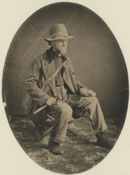
“Studio portrait of geologist Charles Whittlesey dressed for a field trip.” Circa 1858.
~ Wisconsin Historical Society
His detailed examination extended along the copper range from the extreme east of Point Keweenaw to Ontonagon, through the Porcupine mountain to the Montreal river, and thence to Long lake in Wisconsin, a distance of two hundred miles. In 1849, 1850 and 1858 he explored the valley of the Menominee river from its mouth to the Brule. He was the first geologist to explore the South range. The Wisconsin Geological Survey (Vol. 3 pp. 490 and 679) says this range was first observed by him, and that he many years ago drew attention to its promise of merchantable ores which are now extensively developed from the Wauceda to the Commonwealth mines, and for several miles beyond. He examined the north shore from Fond du Lac east, one hundred miles, the copper range of Minnesota and on the St. Louis river to the bounds of our country. His report was published by the state in 1865, and was stated by Professor Winchill to be the most valuable made.
All his geological work was thorough, and the development of the mineral resources which he examined, and upon which he reported, gave the best proofs of his scientific ability and judgment.

“Outline Map Showing the Position of the Ancient Mine Pits of Point Keweenaw, Michigan by Charles Whittlesey.”
~ Smithsonian Contributions to Knowledge, Volume XIII., Article IV., frontpiece of “Ancient Mining on the Shores of Lake Superior” by Charles Whittlesey, 1863.
With the important results from his labors in Ohio in mind, the state of Wisconsin secured his services upon the geological survey of that state, carried on in 1858, 1859 and 1860, and terminated only by the war. The Wisconsin survey was resumed by other parties, and the third volume of the Report for Northern Wisconsin, page 58, says:
The Contract of James Hall with Charles Whittlesey is available from the Journal of the Assembly of Wisconsin, Volume I, pages 178-179, 1862. Whittlesey was to perform “a careful geological survey of the country lying between the Montreal river on the east, and the westerly branches of [the] Bad River on west”. This contract was unfulfilled due to the outbreak of the American Civil War. Whittlesey independently published his survey of the Penokee Mountains in 1865 without Hall. Some of Whittlesey”s pamphlets have been republished here on Chequamegon History in the Western Reserve category of posts.“The only geological examinations of this region, however, previous to those on which the report is based, and deserving the name, were those of Colonel Charles Whittlesey of Cleveland, Ohio. This gentleman was connected with Dr. D. D. Owen’s United States geological survey of Wisconsin, Iowa and Minnesota, and in this connection examined the Bad River country, in 1848. The results are given in Dr. Owen’s final report, published in Washington, in 1852. In 1860 (August to October) Colonel Whittlesey engaged in another geological exploration in Ashland, Bayfield and Douglass counties, as part of the geological survey of Wisconsin, then organized under James Hall. His report, presented to Professor Hall in the ensuing year, was never published, on account of the stoppage of the survey. A suite of specimens, collected by Colonel Whittlesey during these explorations, is at present preserved in the cabinet of the state university at Madison, and it bears testimony to the laborious manner in which that gentleman prosecuted the work. Although the report was never published, he has issued a number of pamphlet publications, giving the main results obtained by him. A list of them, with full extracts from some of them, will be found in an appendix to the report. In the same appendix I have reproduced a geological map of this region, prepared by Colonel Whittlesey in 1860.”

“Geological Map of the Penokie Range.” by Charles Whittlesey, Dec. 1860.
~ Geology of Wisconsin. Survey of 1873-1879. Volume III., 1880, Plate XX, page 214.
~ Biographical Register of the Officers and Graduates of the United States Military Academy at West Point, New York, since its establishment in 1802 by George W. Cullum, page 496.
“The Baltimore Plot was an alleged conspiracy in late February 1861 to assassinate President-elect Abraham Lincoln en route to his inauguration. Allan Pinkerton, founder of the Pinkerton National Detective Agency, played a key role by managing Lincoln’s security throughout the journey. Though scholars debate whether or not the threat was real, clearly Lincoln and his advisors believed that there was a threat and took actions to ensure his safe passage through Baltimore, Maryland.”
~ Wikipedia.org
Such was Colonel Whittlesey’s employment when the first signs of the civil war appeared. He abandoned it at once. He became a member of one of the military companies that tendered its services to President-elect Lincoln, when he was first threatened, in February, 1861. He became quickly convinced that war was inevitable, and urged the state authorities that Ohio be put at once in preparation for it; and it was partly through his influence that Ohio was so very ready for the fray, in which, at first, the general government relied on the states. Two days after the proclamation of April 15, 1861, he joined the governor’s staff as assistant quartermaster-general. He served in the field in West Virginia with the three months’ men, as state military engineer; with the Ohio troops, under General McClellan, Cox and Hill. At Seary Run, on the Kanawha, July 17, 1861, he distinguished himself by intrepidity and coolness during a severe engagement, in which his horse was shot under him. At the expiration of the three months’ service, he was appointed colonel of the Twentieth regiment, Ohio volunteers, and detailed by General Mitchell as chief engineer of the department of Ohio, where he planned and constructed the defenses of Cincinnati.
“[Brother] Asaph Whittlesey [Jr.] dressed for his journey from Ashland to Madison, Wisconsin, to take up his seat in the state legislature. Whittlesey is attired for the long trek in winter gear including goggles, a walking staff, and snowshoes.” Circa 1860.
~ Wisconsin Historical Society
“SIR: Will you allow me to suggest the consideration of a great movement by land and water, up the Cumberland and Tennessee rivers.
“First, Would it not allow of water transportation half way to Nashville?
“Second, Would it not necessitate the evacuation of Columbus, by threatening their railway communications?
“Third, Would it not necessitate the retreat of General Buckner, by threatening his railway lines?
“Fourth, Is it not the most feasible route into Tennessee?”
This plan was adopted, and Colonel Whittlesey’s regiment took part in its execution.
In April, 1862, on the second day of the battle of Shiloh, Colonel Whittlesey commanded the Third brigade of General Wallace’s division — the Twentieth, Fifty-sixth, Seventy-sixth and Seventy-eighth Ohio regiments. “It was against the line of that brigade that General Beauregard attempted to throw the whole weight of his force for a last desperate charge; but he was driven back by the terrible fire, that his men were unable to face.” As to his conduct, Senator Sherman said in the United States senate.1
The official report of General Wallace leaves little to be said. The division commander says, “The firing was grand and terrible. Before us was the Crescent regiment of New Orleans; shelling us on our right was the Washington artillery of Manassas renown, whose last charge was made in front of Colonel Whittlesey’s command.”
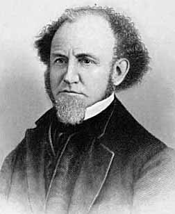
“This is an engraved portrait of Charles Whittlesey, a prominent soldier, attorney, scholar, newspaper editor, and geologist during the nineteenth century. He participated in a geological survey of Ohio conducted in the late 1830s, during which he discovered numerous Native American earthworks. In 1867, Whittlesey helped establish the Western Reserve Historical Society, and he served as the organization’s president until his death in 1886. Whittlesey also wrote approximately two hundred books and articles, mostly on geology and Ohio’s early history.”
~ Ohio History Central
General Force, then lieutenant-colonel under Colonel Whittlesey, fully describes the battle,2 and quotes General Wallace. “The nation is indebted to our brigade for the important services rendered, with the small loss it sustained and the manner in which Colonel Whittlesey handled it.”
Colonel Whittlesey was fortunate in escaping with his life, for General Force says, it was ascertained that the rebels had been deliberately firing at him, sometimes waiting to get a line shot.
Colonel Whittlesey had for some time been in bad health, and contemplating resignation, but deferring it for a decisive battle. Regarding this battle as virtually closing the campaign in the southwest, and believing the Rebellion to be near its end, he now sent it in.
General Grant endorsed his application, “We cannot afford to lose so good an officer.”
“Few officers,” it is said, “retired from the army with a cleaner or more satisfactory record, or with greater regret on the part of their associates.” The Twentieth was an early volunteer regiment. The men were citizens of intelligence and character. They reached high discipline without severity, and without that ill-feeling that often existed between men and their officers. There was no emergency in which they could not be relied upon. “Between them and their commander existed a strong mutual regard, which, on their part, was happily expressed by a letter signed by all the non-commissioned officers.”
“CAMP SHILOH, NEAR PITTSBURGH LANDING, TENNESSEE, April 21, 1862.
“COL. CHAS. WHITTLESEY:
“Sir — We deeply regret that you have resigned the command of the Twentieth Ohio. The considerate care evinced for the soldiers in camp, and, above all, the courage, coolness and prudence displayed on the battle-field, have inspired officers and men with the highest esteem for, and most unbounded confidence in our commander.
“From what we have seen at Fort Donelson, and at the bloody field near Pittsburgh, on Monday, the seventh, all felt ready to follow you unfalteringly into any contest and into any post of danger.
“While giving expression to our unfeigned sorrow at your departure from us, and assurance of our high regard and esteem for you, and unwavering confidence as our leader, we would follow you with the earnest hope that your future days may be spent in uninterrupted peace and quiet, enjoying the happy reflections and richly earned rewards of well-spent service in the cause of our blessed country in its dark hour of need.”
Said Mr. W. H. Searles, who served under him, at the memorial meeting of the Engineers Club of Cleveland: “In the war he was genial and charitable, but had that conscientious devotion to duty characteristic of a West Point soldier.”
Since Colonel Whittlesey’s decease the following letter was received:
“CINCINNATI, November 10, 1886.
“DEAR MRS. WHITTLESEY: — Your noble husband has got release from the pains and ills that made life a burden. His active life was a lesson to us how to live. His latter years showed us how to endure. To all of us in the Twentieth Ohio regiment he seemed a father. I do not know any other colonel that was so revered by his regiment. Since the war he has constantly surprised me with his incessant literary and scientific activity. Always his character was an example and an incitement. Very truly yours,
“M. F. Force.”
Colonel Whittlesey now turned his attention at once again to explorations in the Lake Superior and upper Mississippi basins, and “new additions to the mineral wealth of the country were the result of his surveys and researches.” His geological papers commencing again in 1863, show his industry and ability.
It happened during his life many times, and will happen again and again, that his labors as an original investigator have borne and will bear fruit long afterwards, and, as the world looks at fruition, of much greater value to others than to himself.
~ Report of a geological survey of Wisconsin, Iowa, and Minnesota: and incidentally of a portion of Nebraska Territory, by David Dale Owen, 1852, page 420.
He prognosticated as early as 1848, while on Dr. Owen’s survey, that the vast prairies of the northwest would in time be the great wheat region. These views were set forth in a letter requested by Captain Mullen of the Topographical Engineers, who had made a survey for the Northern Pacific railroad, and was read by him in a lecture before the New York Geographical society in the winter of 1863-4.
He examined the prairies between the head of the St. Louis river and Rainy Lake, between the Grand fork of Rainy Lake river and the Mississippi, and between the waters of Cass Lake and those of Red Lake. All were found so level that canals might be made across the summits more easily than several summits already cut in this country.
In 1879 the project attracted attention, and Mr. Seymour, the chief engineer and surveyor of New York, became zealous for it, and in his letters of 1880, to the Chambers of Commerce of Duluth and Buffalo, acknowledged the value of the information supplied by Colonel Whittlesey.
Says the Detroit Illustrated News:
“A large part of the distance from the navigable waters of Lake Superior to those of Red river, about three hundred and eight miles, is river channel easily utilized by levels and drains or navigable lakes. The lift is about one thousand feet to the Cass Lake summit. At Red river this canal will connect with the Manitoba system of navigation through Lake Winnipeg and the valleys of the Saskatchewan. Its probable cost is given at less than four millions of dollars, which is below the cost of a railway making the same connections. And it is estimated that a bushel of wheat may be carried from Red river to New York by water for seventeen cents, or about one-third of the cost of transportation by rail.”
We approach that part of the life of Colonel Whittlesey which was so valuable to our society. The society was proposed in 1866.3 Colonel Whittlesey’s own account of its foundation is: “The society originally comprised about twenty persons, organized in May, 1867, upon the suggestion of C. C. Baldwin, its present secretary. The real work fell upon Colonel Whittlesey, Mr. Goodman and Mr. Baldwin, Mr. Goodman devoting nearly all of his time until 1872 (the date of his death).” The statement is a very modest one on the part of Colonel Whittlesey. All looked to him to lead the movement, and none other could have approached his efficiency or ability as president of the society.
The society seemed as much to him as a child is to a parent, and his affection for it has been as great. By his learning, constant devotion without compensation from that time to his death, his value as inspiring confidence in the public, his wide acquaintance through the state, he has accomplished a wonderful result, and this society and its collections may well be regarded as his monument.
Mr. J. P. Holloway, in his memorial notice before the Civil Engineer’s club, of which Colonel Whittlesey was an honorary member, feelingly and justly said:
“Colonel Whittlesey will be best and longest remembered in Cleveland and on the Reserve, for his untiring interest and labors in seeking to rescue from oblivion the pioneer history of this portion of the state, and which culminated in the establishment of the present Western Reserve Historical society, of which for many years he was the presiding officer. It will be remembered by many here, how for years there was little else of the Western Reserve Historical society, except its active, hard working president. But as time moved on, and one by one the pioneers were passing away, there began to be felt an increasing interest in preserving not only the relics of a by-gone generation, but also the records of their trials and struggles, until now we can point with a feeling of pride to the collections of a society which owes its existence and success to a master spirit so recently called away.”
The colonel was remarkably successful in collecting the library, in which he interested with excellent pecuniary purpose the late Mr. Case. He commenced the collection of a permanent fund which is now over ten thousand dollars. It had reached that amount when its increase was at once stopped by the panic of 1873, and while it was growing most rapidly. The permanent rooms, the large and very valuable museum, are all due in greatest measure to the colonel’s intelligent influence and devotion.
I well remember the interest with which he received the plan; the instant devotion to it, the zeal with which at once and before the society was started, he began the preparation of his valuable book, The Early History of Cleveland, published during the year.
Colonel Whittlesey was author of — I had almost said most, and I may with no dissent say— the most valuable publications of the society. His own very wide reputation as an archaeologist and historian also redounded to its credit. But his most valuable work was not the most showy, and consisted in the constant and indefatigable zeal he had from 1867 to 1886, in its prosperity. These were twenty years when the welfare of the society was at all times his business and never off his mind. During the last few years Colonel Whittlesey has been confined to his home by rheumatism and other disorders, the seeds of which were contracted years before in his exposed life on Lake Superior, and he has not been at the rooms for years. He proposed some years since to resign, but the whole society would have felt that the fitness of things was over had the resignation been accepted. Many citizens of Cleveland recall that if Colonel Whittlesey could no longer travel about the city he could write. And it was fortunate that he could. He took great pleasure in reading and writing, and spent much of his time in his work, which continued when he was in a condition in which most men would have surrendered to suffering.
Colonel Whittlesey did not yet regard his labors as finished. During the last few years of his life religion, and the attitude and relation of science to it, engaged much of his thought, and he not unfrequently contributed an editorial or other article to some newspaper on the subject. Lately these had taken more systematic shape, and as late as the latter part of September, and within thirty days of his death, he closed a series of articles which were published in the Evangelical Messenger on “Theism and Atheism in Science.” These able articles were more systematic and complete than his previous writings on the subject, and we learn from the Messenger that they will be published in book form. The paper says:
Colonel Charles Whittlesey of this city, known to our readers as the author of an able series of articles on “Theism and Atheism in Science” just concluded, has fallen asleep in Jesus. One who knew the venerable man and loved him for his genuine worth said to us that “his last work on earth was the preparation of these articles . . . which to him was a labor of love and done for Christ’s sake.”
!["The Old Whittlesey Homestead, Euclid Avenue [Cleveland, Ohio]." ~ Historical Collections of Ohio in Two Volumes, by Henry Howe, 1907, page 521.](https://chequamegonhistory.com/wp-content/uploads/2016/05/whittlesey-home-cleveland.jpg)
“The Old Whittlesey Homestead, Euclid Avenue.” [Cleveland, Ohio]
~ Historical Collections of Ohio in Two Volumes by Henry Howe, 1907, page 521.
Colonel Whittlesey was married October 4, 1858, to Mrs. Mary E. (Lyon) Morgan4 of Oswego, New York, who survives him; they had no children.
!["Char. Whittlesey - Cleveland Ohio, Oct. 30, 1895[?] - Geologist of Ohio." ~ Wisconsin Historical Society](https://chequamegonhistory.com/wp-content/uploads/2016/05/charles-whittlesey-geologist.jpg)
Charles Whittlesey died on October 18th, 1886, and was never Ohio’s State Geologist.
“Char. Whittlesey – Cleveland Ohio, Oct. 30, 1895[?] – Geologist of Ohio.”
~ Wisconsin Historical Society
Much of his work does not therefore appear in that complete and systematic shape which would make it best known to the general public. But by scholars in his lines of study in Europe and America, he was well known and very highly respected. “His contributions to literature,” said the New York Herald,5 “have attracted wide attention among the scientific men of Europe and America.”
Whittlesey Culture:
A.D. 1000 to 1600
“‘Whittlesey Culture’ is an archaeological designation referring to a Late Prehistoric (more appropriately: Late Pre-Contact) North American indigenous group that occupied portions of northeastern Ohio. This culture isdistinguished from other so-called Late Prehistoric societies mainly by distinctive kinds of pottery. Many Whittlesey communities were located on plateaus overlooking stream valleys or the shores of Lake Erie. The villages often were surrounded with a pallisade or a ditch, suggesting a need for defense.
“The Whittlesey culture is named for Charles Whittlesey, a 19th century geologist and archaeologist who was a founder of the Western Reserve Historical Society.”
As an American archaeologist, Colonel Whittlesey was very learned and thorough. He had in Ohio the advantage of surveying its wonderful works at an early date. He had, too, that cool poise and self-possession that prevented his enthusiasm from coloring his judgment. He completely avoided errors into which a large share of archaeologists fall. The scanty information as to the past and its romantic interest, lead to easy but dangerous theories, and even suffers the practice of many impositions. He was of late years of great service in exposing frauds, and thereby helped the science to a healthy tone. It may be well enough to say that in one of his tracts he exposed, on what was apparently the best evidence, the supposed falsity of the Cincinnati tablet so called. Its authenticity was defended by Mr. Robert Clarke of Cincinnati, successfully and convincingly, to Colonel Whittlesey himself. I was with the colonel when he first heard of the successful defense and with a mutual friend who thought he might be chagrined, but he was so much more interested in the truth for its own sake, than in his relations to it, that he appeared much pleased with the result.
Whittlesey Culture artifacts: “South Park Village points (above) and pottery fragment (below)”
~ Cuyahoga Valley National Park
Among American writers, Mr. Short speaks of his investigations as of “greater value, due to the eminence of the antiquarian who writes them.” Hon. John D. Baldwin says, “in this Ancient America speaks of Colonel Whittlesey as one of the best authorities.” The learned Frenchman, Marquis de Nadaillac and writers generally upon such subjects quote his information and conclusions with that high and safe confidence in his learning and sound views which is the best tribute to Colonel Whittlesey, and at the same time a great help to the authors. And no one could write with any fullness on the archaeology of America without using liberally the work of Colonel Whittlesey, as will appear in any book on the subject. He was an extensive, original investigator, always observing, thoughtful and safe, and in some branches, as in Ancient Mining at Lake Superior, his work has been the substantial basis of present learning. It is noticeable that the most eminent gentlemen have best appreciated his safe and varied learning. Colonel Whittlesey was early in the geological field. Fifty years ago little was known of paleontology, and Colonel Whittlesey cared little for it, perhaps too little; but in economic geology, in his knowledge of Ohio, its surface, its strata, its iron, its coal and its limestone in his knowledge of the copper and iron of the northwest, he excelled indeed. From that date to his death he studied intelligently these sections. As Professor Lapham said he was studying Wisconsin, so did Colonel Whittlesey give himself to Ohio, its mines and its miners, its manufactures, dealings in coal and iron, its history, archaeology, its religion and its morals. Nearly all his articles contributed to magazines were to western magazines, and anyone who undertook a literary enterprise in the state of Ohio that promised value was sure to have his aid.6
In geology his services were great. The New York Herald, already cited, speaks of his help toward opening coal mines in Ohio and adds,“he was largely instrumental in discovering and causing the development of the great iron and copper regions of Lake Superior.” Twenty-six years ago he discovered a now famous range of iron ore.
“ On the Mound Builders and on the geological character and phenomena of the region of the lakes and the northwest he was quoted extensively as an authority in most of the standard geological and anthropological works of America and Europe,” truthfully says the ‘Biographical Cyclopedia.
Colonel Whittlesey was as zealous in helping to preserve new and original material for history as for science. In 1869 he pushed with energy the investigation, examination and measures which resulted in the purchase by the State of Ohio of the St. Clair papers so admirably, fully and ably edited by Mr. William Henry Smith, and in 1882 published in two large and handsome volumes by Messrs. Robert Clarke and Co. of Cincinnati.
Colonel Whittlesey was very prominent in the project which ended in the publication of the Margry papers in Paris. Their value may be gathered from the writing of Mr. Parkman (La Salle) and The Narrative and Critical History of America, Volume IV., where on page 242 is an account of their publication.7 In 1870 and 1871 an effort to enlist congress failed. The Boston fire defeated the efforts of Mr. Parkman to have them published in that city. Colonel Whittlesey originated the plan eventually adopted, by which congress voted ten thousand dollars as a subscription for five hundred copies, and, as says our history: “at last by Mr. Parkman’s assiduous labors in the east, and by those of Colonel Whittlesey, Mr. O. H. Marshall and others in the west,” the bill was passed.
The late President Garfield, an active member of our society, took a lively interest in the matter, and instigated by Colonel Whittlesey used his strong influence in its favor. Mr. Margry has felt and expressed a very warm feeling for Colonel Whittlesey for his interest and efforts, and since the colonel’s death, and in ignorance of it, has written him a characteristic letter to announce to the colonel, first of any in America, the completion of the work. A copy of the letter follows :
“PARIS, November 4, 1886.
“VERY DEAR AND HONORED SIR: It is to-day in France, St. Charles’ day, the holiday I wished when I had friends so called. I thought it suitable to send you to-day the good news to continue celebrating as of old. You will now be the first in America to whom I write it. I have just given the check to be drawn, for the last leaves of the work, of which your portrait may show a volume under your arm.8 Therefore there is no more but stitching to be done to send the book on its way.
“In telling you this I will not forget to tell you that I well remembered the part you took in that, publication as new, as glorious for the origin of your state, and for which you can congratulate yourself, in thanking you I have but one regret, that Mr. Marshall can not have the same pleasure. I hope that your health as well as that of Madame Whittlesey is satisfactory. I would be happy to hear so. For me if I am in good health it is only by the intervention of providence. However, I have lost much strength, though I do not show it. We must try to seem well.
“Receive, dear and honored sir, and for Madame, the assurance of my profound respect and attachment.
“PIERRE MARGRY.”
Colonel Whittlesey views of the lives of others were affected by his own. Devoted to extending human learning, with little thought of self interest, he was perhaps a little too impatient with others, whose lives had other ends deemed by them more practical. Yet after all, the colonel’s life was a real one, and his pursuits the best as being nearer to nature and far removed from the adventitious circumstances of what is ordinarily called polite life.
He impressed his associates as being full of learning, not from books, but nevertheless of all around — the roads the fields, the waters, the sky, men animals or plants. Charming it was to be with him in excursions; that was really life and elevated the mind and heart.
He was a profoundly religious man, never ostentatiously so, but to him religion and science were twin and inseparable companions. They were in his life and thought, and he wished to and did live to express in print his sense that the God of science was the God of religion, and that the Maker had not lost power over the thing made.
He rounded and finished his character as he finished his life, by joint and hearty affection and service to the two joint instruments of God’s revelation, for so he regarded them. Rev. Dr. Hayden testifies: “He had no patience with materialism, but in his mature strength of mind had harmonized the facts of science with the truths of religion.”

Charles Whittlesey
~ Magazine of Western History, Volume V, page 536.
Colonel Whittlesey’s life was plain, regular and simple. During the last few years he suffered much from catarrhal headache, rheumatism and kindred other troubles, and it was difficult for him to get around even with crutches. This was attributed to the exposure he had suffered for the fifteen years he had been exposed in the Lake Superior region, and his long life and preservation of a clear mind was no doubt due to his simple habits. With considerable bodily suffering, his mind was on the alert, and he seemed to have after all considerable happiness, and, to quote Dr Hayden, he could say with Byrd, “thy mind to me a kingdom is.”
Colonel Whittlesey was an original member of the American Association for the Advancement of Science, an old and valued member of the American Antiquarian society, an honorary member of the Ohio State Archaeological and Historical society, with headquarters at Columbus. He was trustee of the former State Archaeological society (making the archaeological exhibition at the Centennial), and although each of these is necessarily to some extent a rival of his pet society, he took a warm interest in the welfare of each.
He was a member of the Society of Americanites of France, and his judgment, learning and communications were much esteemed by the French members of that society. Of how many other societies he was an honorary or other member I can not tell.
C. C. Baldwin.
1 – Speech of May 9, 1862.
2 – Cincinnati Commercial, April 9, 1862.
3 – The society was organized under the auspices of the Cleveland Library Association (now Case Library). The plan occurred to the writer while vice-president of that association. At the annual meeting in 1867, the necessary changes were made in the constitution, and Colonel Whittlesey was elected to the Case Library board for the purpose of heading the historical committee and movement. The result appears in a scarce pamphlet issued in 1867 by the library association, containing, among other things, an account of the formation of the society and an address by Colonel Whittlesey, which is an interesting sketch of the successive literary and library societies of Cleveland, of which the first was in 1811.
4 – Mary E. Lyon was a daughter of James Lyon of Oswego, and sister of John E. Lyon, now of Oswego but years ago a prominent citizen of Cleveland. She m. first Colonel Theophilus Morgan,6 Theophilus,5 Theophilus,4 Theophilus,3 John,2 James Morgan.1 Colonel Morgan was an honored citizen of Oswego. Colonel Morgan and his wife Mary, had a son James Sherman, a very promising young man, killed in 1864 in a desperate cavalry charge in which he was lieutenant, in Sherman’s march to the sea. Mrs. Whittlesey survives in Cleveland.
5 – October, 19, 1886.
6 – The Hesperian, American Pioneer, the Western Literary Journal and Review of Cincinnati, the Democratic Review and Ohio Cultivator of Columbus, and later the Magazine of Western History at Cleveland, all received his hearty support.
7 – These papers were also described in an extract from a congressional speech of the late President Garfield. The extract is in Tract No. 20 of the Historical society.
8 – Alluding to a photograph of Colonel Whittlesey
then with a book under his arm.
Tyler’s Fork Location: Copper Lands
March 19, 2016
By Amorin Mello

“Map and Section Showing the Formations at the Junction of Bad River and Tylers Fork” by R. D. Irving, 1873. Reproduced from the Geology of Wisconsin: Volume III.
LETTER OF J. A. BAILEY, ESQ.,
IN REFERENCE TO THE
TYLER’S FORK PROPERTY.
———–
Office of Ashland Copper Mining Company,
Ashland County, Wis., Oct. 20, 1864.
Messrs. A. Whittlesey F. W. Bartlett,
Gentlemen:
“Asaph Whittlesey dressed for his journey from Ashland to Madison, Wisconsin, to take up his seat in the state legislature. Whittlesey is attired for the long trek in winter gear including goggles, a walking staff, and snowshoes.” Circa 1860.
~ Wisconsin Historical Society
I have made an examination of the trap beds exposed between this and your location, upon the Copper Range, in Sections 15, 16 and 21, Town 45, North, Range 2, West, in this County, and have collected specimens (which are herewith forwarded) from the Ashland Company’s location, and from various points Eastward to your location.
The accompanying sketch of the territory referred to will assist you in locating the several points from which these specimens were taken, the figures upon the sketch indicating the points referred to.

Detail of the Ashland Copper Mine from 1873; located around what is now the main picnic area within Copper Falls State Park.
The specimens No. 1, are from the rocks in place in the bed of the West branch of Bad River, above the falls, near shaft No. 1, and contain a good per centage of native Copper. The copper bearing belt, exposed here across the formation, embraces a breadth of about 500 feet.
Specimens No. 2, are vein rock, from the transverse vein, in which our shaft No. 1 is being sunk. This shaft is now 35 feet deep, carrying small quantities of fine Copper all the way.
Specimens No. 3, are from the outcrop of the Herbert vein, near the junction of the East and West branches of Bad River, containing “gray ore,” or “gray sulphuret of copper.”
Specimens Nos. 4, 5 and 6 are of trap, taken from the rock in place, along Tyler’s Fork, at the points indicated on the sketch of corresponding numbers.
My explorations and survey have been extended only to a short distance East of the Section line dividing Sections 16 and 17.
The surveys have been carefully made with theodolite and chain, with the view to determine the true course of the copper bearing belt through the “Ashland Company’s” property, and that adjoining on the East; and as near as I can determine from the measurements and the character of the rocks exposed, the course of this belt is East and West, or nearly so, through Section 17, with indications of a curve to the Northward, as we approach to, and enter Section 16.
I have indicated on the sketch the position of what I consider the North line of the outcrop of the copper bearing belt. The South line is not determined, the rocks being covered by drift, sand, &c.
It will be proper for me to add that the productive trap formation, found in place above the falls, in the West branch, corresponds fully with the formation at the same elevation in Tyler’s Fork, on the Western boundary of Section 16; and I am clearly of the opinion that at that point the trap formation, when penetrated to a depth corresponding to that at the falls of the West branch, will be alike productive of copper, and that the most productive veins will be found running parallel with the formation.
Very respectfully, Yours, &c.,
J. A. BAILEY,
Supt. & Engineer A. C. M. Co.
—————-
A letter from Mr. E. Leehy, of Bad River Falls, dated Jan’y 6, 1865, states that in shaft No. 2, on the Ashland mine, several hundred feet South of No. 1, and in the productive belt, the copper rock was reached at 20 feet in depth, and the first blast threw out several pounds of native copper in pieces from the size of an egg down.

“Property on which ‘Silver Lead’ has recently been discovered.”
TYLER’S FORK LOCATION.
——-~~0~~——-
COPPER LANDS,
IN
SECTIONS 15 16 AND 21, TOWN 45, NORTH, RANGE 2, WEST.
640 ACRES.
ASHLAND COUNTY, WISCONSIN.

Detail of Township 45 North, Range 2 West, from Charles Whittlesey’s 1860 Geological Map of the Penokie Range.
This location covers a great part, if not all of the breadth of the productive trap formation. The outcrop of the strata is here nearly East and West, with a curve to the North-Eastward on or near this land. The greatest length of the location is North and South, and therefore crosses the formation nearly at right angles. At the Northern end, is the conglomerate and sand rock, which overlies the trap beds. These beds are better exposed at the West, in Section 17, on the Ashland Copper Company’s land, where they are now working and whatever developments may be made there will apply to this property. The strata have a sharp dip to the North, and are thus exposed at the edges, being nearly vertical. Next below, and South of the conglomerate, is a band of black and red trap, of a compact and rather flinty structure, about three hundred (300) feet thick, in which there are numerous transverse veins, cutting the strata at various angles. These are visible in a deep gulf formed on both forks of Bad River, that unite in Section 17. Somme of these cross veins carry copper, both native and as an ore in the form of grey sulphuret. They also carry as vein matter, chlorite, cale, spar, and flucan, or red and green magnesian clay. There are also narrow beds of trap, interstratified with the hard ores, which are softer, owing to a large portion of laumonite. I do not regard the true veins in the upper beds, as likely to furnish mining ground; but as highly valuable indications, which are to be followed into the more promising strata lower down in the system. Next below the hard beds, to the South, is a belt of trap rocks, whose composition and texture I regard as highly favorable.
The Ashland Company is sinking on a cross or transverse vein, at the Southern border of the hard beds; which in the course of 75 or 100 feet along their inclined shaft, will enter what I consider productive ground. The thickness of this ground is not determined, but what I have seen in the branches of the river exceeds half a mile. It is not, however, all alike, as there are in it layers possessing different characters, corresponding in this respect other parts of the trap range in Michigan and Wisconsin.
The stratum at the head of the falls, on the West fork, where the Ashland Company is at work, has been closely examined over a breadth of about 50 feet, and carries small pieces or nuggets of native copper throughout. It is a soft brown amyglaloid, which small bunches of chlorite, spar and laumonite; some prehnite and quartz, in which the copper is found. Lumps weighing one to two pounds have been obtained from this bed away from any appearances of a vein. This is the general character of the mineral belt on Section 17, which I consider as the true mining ground of this part of the range. All these beds are embraced in our location, at a distance of ¼ to ⅓ of a mile on the East. In Sections 16 and 21, the exposure of rock is not as extensive as it is upon 17, for the rocks are covered by drift clay, sand and gravel, except in the streams.
There is no canoe navigation on Tyler’s Fork, or the Upper Bad River, so swift is the current and narrow and crooked are the channels.
Tyler’s Fork comes out of the mountains about twelve miles southeast by south from Woods’s [at Leihy’s Saw Mill], in a chasm, two hundred feet deep deep, in the red sand-rock and conglomerate. The junction of its ten branches takes place in this narrow gulf or ‘cañon,’ the eastern branch making a plunge of forty-two feet, succeeded, as you ascend, by a series of chutes over trap-rocks forty feet in one-fourth of a mile. Mr. D. Tyler, of the Charter Oak Company, made a location here, and built a rude cabin at the edge of the falls.”
Geological Report on That Portion of Wisconsin Bordering on the South Shore of Lake Superior. Surveyed in the Year 1849, Under the Direction of David Dale Owen, United States Geologist, by Charles Whittlesey, Head of Sub-Corps, page 433.
“Studio portrait of geologist Charles Whittlesey dressed for a field trip.” Circa 1858.
~ Wisconsin Historical Society
The East, or “Tyler’s” Fork, shows the trap beds in its channel a large part of the way through Section 16; and they are visible in the small creek that empties into it on Section 21, from the South. To examine the metal-bearing bed, of which I have spoken, after it reaches this location, the rocks must be uncovered by trenches or shafts in the sand and gravel, after having determined the true course of the bed. The search for cross veins can be easily made in the channel of Tyler’s Fork. This is a stream of considerable value for water power, the fall in your property being sufficient for two dams, and the flow of water sufficient for a saw mill. The Exploration of the porous laumonite beds, will be somewhat tedious; but the close proximity to those on the Ashland Company’s property will be of great assistance. As soon as it is demonstrated that these deposits of fine and nugget copper are remunerative at one point on the range, it gives new value to the whole system. Copper deposited in this mode, in other mining districts, has been found to be more uniform over long distances, than it is in veins; because these ores are liable to pass out of the property formations, and into a diabase rock. These copper-bearing longitudinal courses should therefore be most thoroughly searched. In this region, stamp mills can be worked in most cases by water power; a heavy and regular bed can be stoped and broken up ready for the mill, at a much cheaper rate per fathom, than vein matter. The improved stamps, crushers and washers, have of late years much reduced the expence of working mineral-bearing rock. The absence of masses of native copper in the Ashland district, is not now so important as it was when the first explorers made their location here. On this property, the length of the copper-bearing beds is something over a mile, and their breadth at least half a mile. As they extend to a greater depth than any mine can be worked, there is no fear of exhaustion.
CHAS. WHITTLESEY
Geologist and Mining Engineer.
Cleveland, Ohio, Jan. 1st, 1865.
Barber Papers: “Barbers Camp” Fall of 1855
September 19, 2015
By Amorin Mello
Selected letters of the Joel Allen Barber Papers
… continued from Summer of 1855.
Johnson Sept 26th 1855
Dear Son
Although but two days have elapsed since I wrote to you & Augustus jointly, the spirit moves me to try it again, first to correct a very great error I committed at that time by enclosing the handbill issued by your Uncle Burr for the apprehension of the murderer of Abial Chase, I merely sent it that you might see it as I would have handed it to you to look at, if you had been here, but the soul & essence of all propriety chid me smartly for it calling it “foolish, childish & very improper” so I suppose it was, and if this will answer for an apology, I will pass on to the 2nd article. That is the bursting up of the Bobkin concern, which took place this morning.
“The murder of Abial Chase by Jefferson Fulton : on the 6th day of Sept. A.D. 1855, at Fletcher, and the suicide of Fulton on the 10th. With an explanatory account of the original difficulties between them, and the circumstances attending the death of each party.”
~ by Wilson & Henderson; published by Messenger Print, St. Albans, VT; 1855.
There is considerable mystery attending the transactions for they have been making money rapidly and there is apparently no cause for such a move, I worked hard from breakfast to now removing property from their shop to my barn. It looks as though they had got sick of their location and wanted to get away to some other. Their stock of hides of all kinds are all done up & sent to market & their [pits?] empty, the copper boiler taken out, and sent off. Old Bobin has been out west this summer & has probably found a place where he & Frank are going & perhaps Phelps too & they cut up this [shine?] to get rid of the place and turn their [???????] in to pay their debt to [Sen?] Knight about $230.
The Barber brothers, Augustus and Allen, surveyed the first three of six townships for the General Land Office during the Summer of 1855, which included what are now the Cities of Ashland and Washburn. The Barber brothers continued their survey contract with the second three of six townships into the Fall of 1855; before, during, and after the 1855 Annuity Payment.
Hiram has been up to the cattle show at Hydepark to day and has got home just at dusk pretty well used up having been up on foot, as did Benton & Leo Hyde, though they are coming down by stage & Am footed it back. I had no notion of going up there as I have long been sick of going there, so I took my name off and bode them a final adieu. I go to Hydepark as seldom as possible because I love the place and people so well.
As I said in my last, I expected a letter from you at the same time my letter started, so I found it, for yesterday Morning I found one from Augustus which was right welcome as it brought news of the continued good health of you both.
“At Vanderventer’s Creek, near Washburn, was the Celebrated Gigito-Mikana, or “council-trail,” so called because here the Chippewas once held a celebrated council; hence the Indian name Gigito-Mikana-Sibiwishen, meaning “Council-trail Creek.” At the mouth of this creek, there was once a large Indian village.”
~ Collections of the State Historical Society of Wisconsin, Volume 13, pages 432
I am glad Augustus is so punctual in writing and it seems as if you could give us a few lines once in a while as well as he.
Will you try it? Benton delivered a lecture last evening to a full house. Subject, the proper course of Education in relation to the remarkable progress of the age, as necessary to the requisite training & diciplining of the mind.
It rains & I have got to go and carry this to the office, so you must excuse my brevity.
May God bless you both
G.A. Barber
PS. Some groaning about writing so often
Johnson Sept 30th 1855
“Nedobikag-Sibiwishen is the Indian name for Bay City Creek, within the limits of Ashland. Here Tagwagane, a celebrated Indian chief of the Crane totem, used occasionally to reside. Warren gives us a speech of his, at the treaty of La Pointe in 1842. This Tagwagane had a copper plate, an heirloom handed down in his family from generation to generation, on which were rude indentations and hieroglyphics deonting the number of generations of that family which had passed away since they first pitched their lodges at Shagawamking [Chequamegon] and took possession of the adjacent country, including Madelaine Island. From this original mode of reckoning time, Warren concludes that the ancestors of said family first came to La Pointe circa A.D. 1490.“
~ Collections of the State Historical Society of Wisconsin, Volume 13, pages 430Dear Sons
Having written twice within the last week I have but very little to say now that may be interesting to you, but as I have determined to write as often as once a week and oftener if any thing transpires worthy of the mention of it, I again set myself to the work. In my letter of last Wednesday night I mentioned the [vainose?] of Mr Bobkin from these diggings and the attachment of all the effects of [Phelps ?] Bobkin on the debts of sundry individuals. Thursday morning B’s little wife Jane went over to Montpelier to his father’s to go with them westward the Lord knows where.
Charles [Judivene?] who has lived in the house with them is going soon. People think Phelps is soon to follow. [Hawley?] Smith & family & [Hm?] Smith & family go this week. I sent you a Methodist Paper with the notice for the dedication of our new Chapel therein and also was scribbled on it the startling news of the fall of Sevastapol which was telegraphed from Halifax the day before. Some doubted but Boston Papers brought the news yesterday morning & this morning the [Sumlokg?] Tribune brought a full confirmation, with some of the particulars of the bloody encounter.
The Barber brothers included many details in their surveys, including this one of an Indian Sugar Camp (T48N R5W).
The Bombardment commenced upon the [Malakoff?] Little Redan at [Carediring Bay?] by the French & the Redan by the English at day break on the 5th & continued to Morn the 8th when the assault commenced.
You will receive the news of the battle by papers to be printed this week & probably this will reach you first. So that I may be the means of giving you intelligence of great importance sooner than you would otherwise get it.
“According to Blatchford there was formerly another considerable village at the mouth of Whittlesey’s Creek, called by the Indians Agami-Wikwedo-Sibiwishen, which signifies “a creek on the other side of the bay,” from agaming (on the other side of a river, or lake), wikwed (a bay), and sibiwishen (a creek).”
~ Collections of the State Historical Society of Wisconsin, Volume 13, pages 430-1
Mum always says that it is useless to try to give early news because you will hear of it sooner or later, and what is the use of writing again so soon? I always that if anything transpires worth relating that then is the time to tell it. I have been to Meeting to hear Mr D all day as I usually do when at home, especially since the baptists [rave?] got their new man Mr Mirriman to preach to them and all creation are running to hear him on the new broom principle. Mum and Am have gone to Cambridge to day to try to find a girl, & I see by her letter to you that she is complaining that I do not [figosure rup?] for her, & that She has too much to do &c&c. I would at any time get a girl for her did I not know that it would only furnish [new?] grounds of complaints. If I got a little girl then there would be trouble for thinking that She could get along with such help, that it was no help at all & made her as much work as it saved, while should I get an older girl she would soon discover certainly as soon as she got rested that she could get along without any or with a little [one?]. It is a fact, that her mind is not as stable and unchanging as the Green Mountains, and in regard to what she says of my not telling her my plans, I will barely say that so long as she does not know them she cannot combat them, which she surely would, whatever they were and in regard to my having run through all the [offices?] &c & taking a pretty clerkshop, it is all news to me coming from her [diseased brain?]
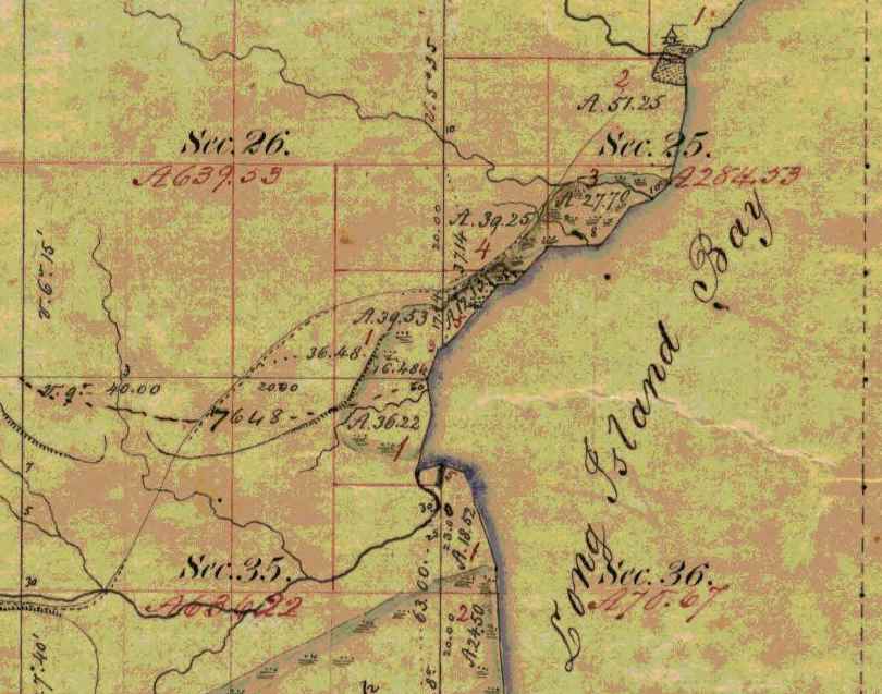
Detail of T48N R5W:
Chequamegon Bay;
an named settlement at the mouth of Boyd Creek;
the Whittlesey Creek National Wildlife Refuge;
and the trailhead of the Grand Footpath.
“Boyd’s Creek is called in Chippewa, Namebinikanensi-Sibiwishen, meaning “Little Sucker Creek.” A man named [Robert] Boyd once resided there, married to an Indian woman. He was shot in a quarrel with another man.”
~ Collections of the State Historical Society of Wisconsin, Volume 13, pages 431-2
“From this place northward, there were Indian hamlets strung along the western shore of the bay. Father Allouez mentions visiting various hamlets two, three, or more (French leagues away from his chapel. Marquette mentions five clearings, where Indian villages were located.“
~ Collections of the State Historical Society of Wisconsin, Volume 13, pages 431
I have been talking with the [boiv’s?] about making my way into cloth for me: and I am convinced that by so doing I can realize 45 or 50 cents per lb for my [westwhoaor?] should I sell it now I could get 34 ¢ per lb for 20 [place?] and only 25 cent per lb for the remainder. It is the very thing that Mum proposed and urged to me weeks ago when I talked of selling it. But now I have concluded to do so she is in distress for fear I shall have to go out there to sell it. I have been thinking of going in [December?] to buy lumber & get it in the ground & make preparations for some improvements on the little farm and I think some good [G??? ???] into [franned?] will be good articles in [enough?] a [country?]. I am in hopes to have [on yes?] cloth or perhaps [?????] cloth & [?????? ?????? or more?]. So my object is to spend my money. Mum says [???] when she sees in prospect [thall?] I [???] go [while?] no longer ago than yesterday she [pevondered?] why I did not go and be doing something on the place in Lancaster and garden from day to day [having?] down one day the plans she had built u the day before &c &c.
The hop harvest is about through and there is not only a small crop but the prices will be low this season – [same when?] I was at the Institute last week and was much surprised with Am’s performance as [cutic?], and if I can get it, will copy it for you that you may see how he is improving.

Detail of a trail between Chequamegon Bay and the Saint Croix River National Scenic Riverway (T48N R5W). This is the Grand Footpath that was discussed in the Comments section of our Oshogay post.
“A short distance from Whittlesey’s Creek, at the western bend of the bay, where is now Shore’s Landing, there used to be a large Indian village and trading post, kept by a Frenchman. Being at the head of the by a, it was the starting point of the Indian trail to the St. Croix country.”
~ Collections of the State Historical Society of Wisconsin, Volume 13, pages 431
I have just looked for it & cannot find it, but I think you will say when you see if that it is pretty tall for one only 14 years of age. I think he is making pretty good progress in his studies though his mother is in great affliction if he is not bowed down to his books every moment. She thinks he should be kept as close to his books as a hired man or girl at their work and if anything closer, because it is not work.
I shall have some [curly?] to carry with me when I leave this town and would like to get it into [law/land?] in some good place for in that way do I think it would be surest and increase fastest.

Detail of a sand stone boulder (T48N R5W).
Still I know not what I shall do. Perhaps I may live and die in Vermont after all, but I want to be in some more productive vicinity than Johnson and some more pleasant place than our old farm in Cambridge. I can work yet but but as for [eritubing?] those hills & rocks I should beg to be [exensed?], though I should regret to have the wood land & sugar place more them all the rest for they [ground me aplenty?] in this or any other place. But oh [such wish her?] the river has made with the banks within the [two ????] years. It makes me sick when I see it and know that it cannot be helped.
“Further north is Kitchi-Namebinikani-Sibiwishen, meaning “Large Sucker Creek,” but whites now call it Bonos Creek. [Boyd and Bono] creeks are not far apart, and once there was a village of Indians there. It was noted as a place for fishing at a certain time of the year, probably in spring, when suckers and other fish would go up these creeks to spawn.
~ Collections of the State Historical Society of Wisconsin, Volume 13, pages 432
I have got to get supper for [Mrs?] Benton and milk and shall have to close this stupid letter. What do you think of having Am & I out there through the winter? Could we find room any where to lie down and could we find [syinge teethes being?] used to say ??. You will see that I am economical of my paper I cast such an enormous square for postage THREE whole cents a week. It is thought any [exlaws out?] Had I been as intent on (spending money as [reprebuted?] I should have gone to Quebec [last ??? in?] Excursion fare only $3.50 from Essex to Quebec & back again. I am sorry that I did not go, as I am chgd with such a desire to spend money.
May you both prosper in all Laudable pursuits & live long is blessing to your parents & the world
G.A.B.
Interior Field Notes
Township 48 North, Range 5 West
Oct. 1855
Notebook ID: INT049W06

Original plat map of T48N R5W. Today, this is the Town of Barksdale.

Survey of T48N R5W by:
Augustus H. Barber, U.S. Deputy Surveyor.

First page of affidavit; continued below.

Chainmen: J. Allen Barber 2nd & George I. Butler
Axeman: Joseph Dennis
(Joseph Dennis was a mixed-blood member of the Lake Superior Chippewa tribe and eligible for a land grant under the seventh clause of the second article of the 1854 Treaty of La Pointe.)

The Barbers’ original field notes for this township were reproduced in 1891 “…for the reason that the original record is becoming illegible by the fading of the inks.“
[c. Oct 12, 1855]
Barbers Camp Oct 1855
Dear Parents
Being unemployed today I have an opportunity though a poor one to write to you once more.
Detail of Fish Creek Slough (T47N R5W).
My health for a few days past has not been good – in fact I have been obliged to be idle the last two days from a kind of disentery very common here and apt to turn to bloody flux. But I am much better today and hope to resume work tomorrow.

Detail of Metabikitigweiag-Sibiwishen; now known as South Fish Creek (T47N R5W).
~ Collections of the State Historical Society of Wisconsin, Volume 13, page 430.
Our party now contains 3 halfbreeds, two to keep camp and one to ax. At first I did not like the idea of having such looking fellows to work for us but they get up good victuals. I don’t inquire how. I have to cook occasionally but I can’t tell how I make it go. Still my pancakes and fried pork and bean soup are generally devoured with an assiduity not often seen out of the woods. The survey is going on pretty well lately. The fourth town will be finished in 4 or 5 days. Then there will be only two more. We are having very good weather now, perhaps it is the beginning of our indian summer which they say is very fine on this lake. I have not yet made up my mind what I shall do this coming winter.

Details of a spring and trails along Fish Creek; and the footpath from Chequamegon Bay to the Mississippi River via Lac Courte Oreilles (T47N R5W).
~ Collections of the State Historical Society of Wisconsin, Volume 13, page 430.
If I make a claim I shall probably live and work on it. I know of a place near the bay for as good a farm as can be made on the lake, good bottom land — some of it producing good hay now. During the summer there has been some emigration to this country but there is room for more yet. The only settlements about this end of the lake are at Superior, Iron river 27 miles this side, Bark Point bay, La point, this bay, Bad river, & Montreal river. At Bark point there is only a fishery and at Bad river a mission.
Lapointe is a queer old town. Standing in the midst of an almost unknown country it presents the appearance of and is in fact about the oldest town I ever saw. Not a horse or carriage track can be seen in the streets and there is not a carriage road leading from the town. The buildings were mostly constructed without sawed lumber and are mostly enclosed with high fences of sharpened posts. Squaws, half breed children, indian dogs and lice are the principal commodities. French and Ojibway are the principal languages spoken.

Detail of water bodies and trails in the vicinity of the Badgerwood CAFO being proposed by Reicks View Farms in current events, described in 1855 by the Barber brothers as “an elevated ridge, much resembling the Mineral ranges of this region” (T47N R5W).
But a more beautiful bay can’t be found than La point bay. I think it is always a safe and accessible harbour.
Oct. 21st. Since writing the above I have recovered my health and been at work about a week.
Love to all
Allen
[Incomplete copy of letter]
[ca. 1855] Nov. 1
Father’s“letter of November 3, 1856, was written during a rough voyage down Lake Superior and Lake Michigan in the famed steamboat ‘Lady Elgin.'”
This incomplete letter was misfiled as 1855; it was from the Fall of 1858. Stay tuned.
Nov 1st The weather is quite different now from what it was 2 years ago yesterday when I left you to come down on the Lady Elgin & to day when we lay shut in by a NorthEaster at Copper harbor.
I have this A.M. recd a letter from Maime Burr & one from her bother. Maime is a beautiful writer both as to matter & manner.
The folks at Lancaster were well except Cyrus who I fear is consumptive.
It is time for me to go to the House & almost time for the Mail to close.
May Heaven bless & protect you
G.A. Barber
Interior Field Notes
Township 47 North, Range 5 West
Oct. 1855-Nov. 1855
Notebook ID: INT049W05

Original plat map of T47N R05W. Today this is the Town of Eileen.
Survey of T47N R5W by:
Augustus H. Barber, U.S. Deputy Surveyor.
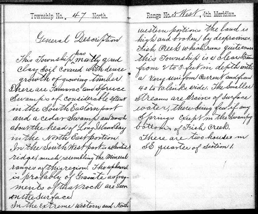
General description of T47N R5W.

Chainmen: J. Allen Barber 2nd & George I. Butler
Axeman: Joseph (his mark) Dennis
Affidavit signed by: John W. Bell, Justice of the Peace for LaPointe County.
The Barbers’ original field notes for this township were reproduced in 1885 “… for the reason that the original record is becoming illegible by the fading of the ink.”
Ashland Wisconsin Dec. 16th 1855
Dear Parents
Once more I am seated to assure you of my continued good health and warm affection for the loved recipients of this letter.
Detail of Ashland townsite, Wikwedong, and Fish Creek (T47N R4W).
“Fish Creek is called by the Indians Wikwedo-Sibiwishen, which means ‘Bay Creek,’ from wikwed, Chippewa for bay; hence the name Wikwedong, the name they have to Ashland, meaning ‘at the bay.'”
~ Collections of the State Historical Society of Wisconsin, Volume 13, page 430.
Asaph Whittlesey founded Ashland in 1854 near the ancient village of Wikwedong.
I suppose Augustus has informed you of the completion of his contract. Our summers work hung on rather late as nearly all of the last township was surveyed after the winter had fairly set in. But we are having an easy time of it now. We are keeping house in a little cabin at Ashland about two miles from Bay City. I do all the house work as well as I can by a little stove exactly like our parlor stove and Augustus works at his notes preparing them for the office. As yet I don’t know what I shall do this winter. Between working with Augustus, going below, making a claim and a few other things, I must decide before long. People are pitching upon claims all around me which I might have claimed when surveyed — yet I hold onto to my preemption right in hopes to find a more valuable location. With my knowledge of the country I could make better selections than most of them do and with the means I could secure several valuable tracts. (Eve.) This evening Augustus and I have been singing with Mr. Whittlesey’s folks, who live only a few steps from us. They are intelligent pious folks and very neighborly. Mrs. W. brought us some apple dumplings the other night and has since sent us a whitefish nicely cooked. I suppose they pity our want of skill in the culinary department of housekeeping. I do some baking in the stove which I find a great help. In regard to dish-washing I am rather fortunate as we have dishes enough for six men and can’t use them all at once so I only wash about once in two days.
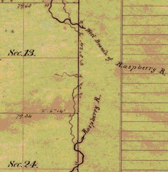
Detail of Raspberry River and West Branch of Raspberry River upstream from Sioux River Slough (T49N R5W).
“Sioux River is a stream located just 4.3 miles from Washburn, in Bayfield County, in the state of Wisconsin, United States, near Sioux, WI. Alternate names for this stream include Miskwimin, Raspberry River and Miskwi Minikan.”
In the Ojibwemowin language, Miskwiwim is Raspberry and Miskwi Minikan is Blood Seed.
The propeller Ogontz survived numerous accidents and a lawsuit upon the Great Lakes.
Butler has left us and gone to Superior intending to go to St. Antony. He did not appear to like the woods very much. Dan Damon of Waterbury had just gone there (to St. Antony). It is announced that there will be preaching here next Sunday by Mr. Warren a young Methodist minister at Bad river mission. I may not be here as we intend to go to La Pointe and probably Superior in two or three days. Provisions are scarce all round the lake I guess. At Superior pork is 25¢ per pound. Here nothing can be obtained by the quantity. At Ontonagon prices are very high. Two cargoes of provisions for Ontonagon have been discharged at some lower port on account of storms. The propeller Ogonts began to unload at Ontonagon but a storm arising she was obliged to put out for a safer harbor and vessel and cargo were much damaged. Last fall a steamboat with passengers for Superior and La pointe landed them at Ontonagon and started back for the Sault but was met by a northeaster and driven back to La pointe. So you see vessels on this lake have to stand round for storms. The bay is partly frozen over. Thermometer this morning 2*-0.

Detail of Sioux River; also labeled as the main branch of the Raspberry River (T49N R5W)
Joseph Alcorn was featured in the Spring of 1855. He appears to have been close to George Riley Stuntz.
Heard today that Jo is at work at Iron River for Stuntz.
I do not know what Augustus will do about surveying this winter. He could probably make it pay better than anything else, I suppose the job lies among the islands which will give plenty of meandering which could be done on the ice at the rate of 9 or 10 miles per day. But nothing can be done about it yet until the channels are frozen over as the water is so full of icebergs part of the time that no small boat could live.
“From all this we see that the bay was from most ancient times the seat of a large aboriginal population. Its geographical position towards the western end of the great lake, its rich fisheries and hunting grounds, all tended to make it the home of thousands of Indians.”
~ Collections of the State Historical Society of Wisconsin, Volume 13, page 433.
The trader of Allen’s yarn was likely present at the 1855 Annuity Payment.
I wish I had time to tell you a lot of yarns about the Indians and indian traders. A Bad River indian came over here today to trade off a beaver skin for whiskey — he got about two quarts for it which made him feel pretty rich yet feeling he had not quite enough he bought a pint more for 50¢ which the trader brought and poured into his keg — but the last pint fortunately was nothing but pure brack water. The same trader one night just after payment took about 75 dollars with only 8 gallons of whiskey well watered.
If we go to La pointe soon this letter will be mailed soon. If not it may stay in this office a week or two.
Please excuse the bad writing, &c, &c.
Your affectionate son
J Allen Barber

Detail of a spring along trail from the Sioux River Valley into the Bayfield Peninsula (T49N R5W).
Dear Mother
I am somewhat in arrears of my usual and promised amount of letter writing but I cannot help it.
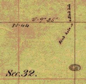
Detail of sink holes (T49N R5W).
In a short time I expect to have more favorable opportunities and a better chance to tell you what I shall do and where I shall be this winter. If I stay about here you must not look for letters every week for it will be quite impossible for me to dispatch them oftener than once in two weeks; perhaps longer times will unavoidably intervene. Am well and sound and feel pretty well able to stand a winter here on the lake, though I must own that to survey in mid-winter seems to me like undertaking a pretty [cool?] job. Never mind, to be at work in the woods here is less tedious and less dangerous than to be on the black prairies of southern Wisconsin where roads are covered deep in an hour or two and no sheltering forest nor even fuel to protect the traveler from the bitter winds. You may, I think, be tolerably easy about my health and safety, recollecting that I have been some time in this wild country and enjoyed better health than [two words illegible] others claim, and as for accidents, no place is known to be safe between the walls of the universe, but the peaceable prudent and prompt men may expect to walk in safety in all places as anybody. Besides, there are men here who have shown that they are disposed to remember sundry little accommodations, and if I should need the care of friends at any time I doubt not I should receive all the attention that well disposed strangers could give.
At present I don’t know much about my operations for the immediate future, but expect to know as I go along. We are woefully neglected by the mails of late, but are no worse off in that respect than others.
Hoping this letter will not be as unsatisfactory to you as it looks to me. I am as
Ever Your Affectionate Son
Augustus H. Barber
Interior Field Notes
Township 49 North, Range 5 West
Nov. 1855-Dec. 1855
Notebook ID: INT050W01

Original plat map for T49N R5W.

Survey of T47N R5W by:
Augustus H. Barber, U.S. Deputy Surveyor.

General description of T49N R5W.

Chainmen: J. Allen Barber 2nd & George I. Butler
Axeman: Joseph (his mark) Dennis
Affidavit signed by: John W. Bell, Justice of the Peace for LaPointe County.
The Barber brothers’ original field notes for this township were reproduced in 1891 “… for the reason that the original record is becoming illegible by the fading of the ink.”
[Incomplete copy of letter]
[undated circa 1855]

Detail of Ironton town property with trails to Odanah and to the Penokee Mountains (T47N R1W). This was not part of the Barber brother’s survey in 1855. Today this property is known as Saxon Harbor.
Is there not danger that by the decisions of the Secretary of the Interior lately rendered, you may be thrown out of your Ironton Town property? Or is there perfect immunity from such loss in the hardship of the times that for the present render the property valueless & no temptation to sharks to seize upon them? You can make your shares perfectly safe by ostensibly making your home there & from what you have hinted about the agent I presume it would be no great displeasure for you to sojourn occasionally with his family, at least enough to have your residence called at Ironton.
And this reminds me of seeing the name of your plan in one of the N.E. Counties of Wis. I think in Marquette it was in an advertisement for proposals for carrying mails in Wis. When do you suppose property of any kind will be saleable again about Lake Superior?
One thing is certain, it must be after [this?], if ever, I would like to hear how some of my acquaintances along down the northern shore are thriving & whether property in & around Burlington, Encampments, Rockville, Beaver Bay are commanding fabulous prices as they did last years. I presume thousands of dollars were paid last year to be shown claims & for building shanties on them, by those who are forced to abandon them, & remain where they are in no danger of starving. Has Perry told you that that note could not be paid for lack of money enough in Superior? What did he say about it? How did he expect I want him to get my pay? I expect nothing but that I should lose all that debt, for I am fearful that Carleton will find some way to avoid the payment of it.
Did Perry talk or not as though he wished to have me paid up? & what did he say about its ever being paid? Does he gamble & drink yet? & how do they all appear in Superior? Does the hardship of the time prevent the consumption of such quantities of rot gut as were formerly used?
Are Mr. [Barmite?] & Mr. [McCorble?] there? Is Frasier there? & Mr. Hall the young lawyer, Charly Port, White Perkins & Bradford? If I can only get my affairs in Superior straightened out I can note if the whole place sinks to the “bottom of the sea, the sea, the sea” & half of its inhabitants with it if I could chose who should be saved.
I have written more than I intended, as times hangs so heavily on my hands that I resort to writing as a pasttime.
Again good bye,
G. A. B.
I send you a blank % sheet for your use. I bought squires like this for 34¢ last week & wish I could get some of it to you.
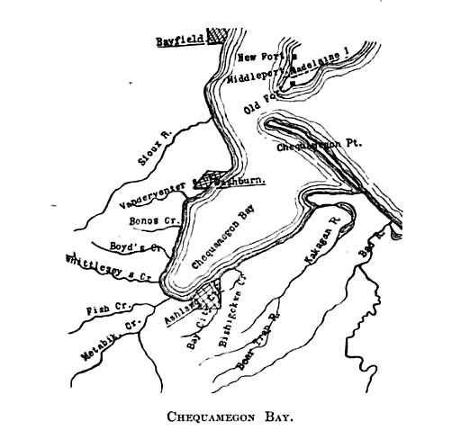
This map is an image from Collections of the State Historical Society of Wisconsin, Volume 13, page 419.
Published in 1895, this map features the area surveyed by the Barber brothers during 1855 surrounded by Bayfield, LaPointe, and Bad River.
After 1855, the Society’s annual reports were included in its Proceedings.
In 1855, the Barber brothers surveyed six townships (216 square miles) along Chequamegon Bay between Bayfield and Bad River.
The available mix of original documents and reproductions of the Barber brothers’ field notes feature these water/land routes; but do not feature any of these ancient villages.
During 1855, did the Barber brothers record these details separately for the State Historical Society of Wisconsin?
To be continued in the Winter of 1856…
Penokee Survey Incidents: Number VII
April 16, 2015
By Amorin Mello
January 5, 1878.
The Survey of the Penoka Range and Incidents Connected with its Early History.
—
Number VII.
Upon the arrival of Gen. Cutler and myself at Milwaukee, December 25th, 1857, we found that the affairs of the Wisconsin & Lake Superior Mining and Smelting Company were in a very different condition, financially, from what they were when we left home, nearly eight months before. The great commercial storm, that, like a tidal wave, had swept over the country that year from Maine to California, had left its mark in wrecking many of the best business men of the “Cream City,” as well as elsewhere. Among these were some of the original stock holders of our company, who, unable to stand their assessments any longer, had, previous to our arrival, given place to others as green as they were originally themselves. Even some of the new stock holders were also subsequently compelled to sell out to other parties, not being any better able to respond when the call for more money was made upon them, than had their illustrious predecessors, thereby losing not only all they had invested, but what they had in prospect to make, as well.
Among those who stepped into the trap at this time and who remained in to the end were Messrs. Green & Button, who yet hold stock, John W. Pixley, Simeon N. Small, J.B.D. Coggswell and R.B. Bell, a one-horse banker who came to our city about that time. The outs being John Lockwood, who, in imagination, had been a large capitalist, and worth at least two hundred thousand dollars; but whose liabilities so far exceeded his ability to pay when brought to the front as to make him a hopeless bankrupt, was, with Palmer, Greves and Cummings, compelled to retire.
The amount of money expended up to this time, in order to obtain possession of this imaginary bonanza had not only floored these gentlemen, leaving them high and dry upon the shoals of commercial bankruptcy, but had so far exceeded the amount originally contemplated, as to make those of us who remained fear the wrath to come in view of the stringency of the money market, as well as the general stagnation of business, particularly, as from past experience, it was not possible to calculate with certainty what further amounts would be required, in order to insure success. A large force was still upon the Range, neither could it be withdrawn until the lands were entered, except at the risk of losing all that had been done. These men were to be paid as well as fed during the winter, which would of itself, require no inconsiderable sum; besides we must pay the Government for the land. Money must be raised, consequently, to go back was impossible; to go forward, equally so. But to go ahead was our motto, and the amount necessary for these purposes was at once raised by assessment upon those of us who were yet solvent, and the “pot kept a boiling.”
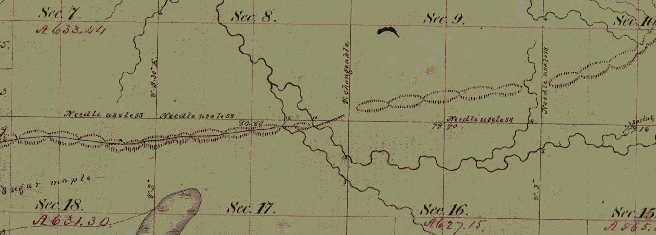
Wheelock’s unmarked townsite claim at Ballou Gap in the Iron Range with sugar bushes, artesian springs, and useless compasses. (Detail of Stuntz’s survey during September of 1857)
During the winter the improvements upon the Range spoken of as contemplated were pushed steadily forward under the skillful management of A.B. Wheelock, who was in every way, the man for the place, as in addition to completing the two block houses in good shape, twelve hundred pounds of sugar and forty gallons of molasses were made under his direction during the spring. The tubs for holding the sugar and syrup were all made during the winter at Penoka, by that Jack of all trades, Steve Sanborn, who could do almost as good work with a hatchet, knife, saw, auger and draw shave, as half the coopers and carpenters in the country, with a full set of tools.
Perhaps a short sketch of this singular mortal, so well known to many of Ashland’s early men, may not be uninteresting to your readers.
In height he was about five feet six inches, broad shoulders, arms long and sinewy, head large and wide; dark complexion, long, dark brown hair, blue eyes, face smooth and beardless, high cheek bones, long, wide, projecting chin, that was always getting up a muss with his nose, which was also long, and slightly hooked. He walked heavily, his knees usually about six inches in advance of his toes, giving his legs, which were bowed, the shape of an obtuse angle. Such was his personale. His conversational powers were not of the highest order – in fact he seldom spoke to any one; was fond of hunting and trapping, a vocation he usually followed every winter, remaining out alone for weeks together, at the Marengo, living upon mink, martin, muskrat, or any other kind of rat. He was always restless and uneasy, and could get outside of more bean soup and shanty bread at a sitting than any two men upon the Range. Such are my recollections of Stephen Sanborn. The last known of him was at Pike’s Peak, where, if living, he is no doubt following the same hermit life he loved so well upon Lake Superior.

Charter of the Ashland and Iron Mountain Railroad Company. ~ The Penokee Iron Range of Lake Superior, with Reports and Statistics Showing Its Mineral Wealth and Prospects: Charter and Organization of the Wisconsin and Lake Superior Mining and Smelting Company, 1860, pg 9
At length, after a winter of unusual mildness, similar to what the present one promises to be, gentle spring once more showed her smiling face, a signal to us to hurry up and complete our work; and as the returns of the survey were now all made, and the lands subject to entry, the necessary funds for entering them were placed in my hands, with which I returned to the Range, took the boys to Superior City, where they made their little affidavits, got their duplicates, and returned with me to La Pointe, where we met the General, who had followed me from Milwaukee, where the work of transferring the titles to the company was at once commenced and completed successfully with all except A.S. Stacy, who traitor-like, (to use a commercial term), “laid down” on us, refusing to convey, unless paid a bonus of one thousand dollars, which, if my memory is correct, and I’ll bet it is, he never got. The duplicates once in our possession, the patents were soon forthcoming, through influence brought to bear at Washington, after which, there being no prospect of doing anything with the lands at present, owing to the financial condition of the country, as well as the almost total prostration of the iron interest. The personal property was placed in store at Sibley’s and other points, until again wanted, and the Range abandoned about July 1, 1858. This abandonment, however, which was at the time supposed to be only temporary, proved in the end, to us at least, eternal. The fruits of our labors are not enjoyed by others. “We shook the bush and they caught the bird.” Notwithstanding that a railroad,- the Ashland and Iron Mountain, of which I, with others, was a corporator, was chartered in 1859, it was, as is well known, never built. We were finally compelled, after all, to see this whole thing, upon which we had spent so much money, and suffered so many hardships, slip from our grasp, and pass into the hands of those who had not labored for it. But so it is ever; one planeth, and another gathereth.

Corporate literature published by the Wisconsin & Lake Superior Mining and Smelting Company. ~ The Penokee Iron Range of Lake Superior, with Reports and Statistics Showing Its Mineral Wealth and Prospects: Charter and Organization of the Wisconsin and Lake Superior Mining and Smelting Company, 1860, pg 1

“List of Lands”
belonging to the Wisconsin & Lake Superior Mining & Smelting Company. ~ The Penokee Iron Range of Lake Superior, with Reports and Statistics Showing Its Mineral Wealth and Prospects: Charter and Organization of the Wisconsin and Lake Superior Mining and Smelting Company, 1860, pg 4
Such, Mr. Editor, is the history in brief, of the way, as well as by whom, the Penoka Range was first surveyed and located, and although we underwent much hardship and privation, yet I look back today upon that summer, as the pleasantest, in many respects, that I ever spent in Wisconsin. Neither would I hesitate, even now, to undertake the same again, and would like very much to see the old cabin at Penoka, which I am told is yet standing, in which I spent so many happy days in 1857.
The history of the Range from that time to the present is as well known to you as to me, and need not be dwelt upon further than to say that its possession did not make millionaires of any of us.
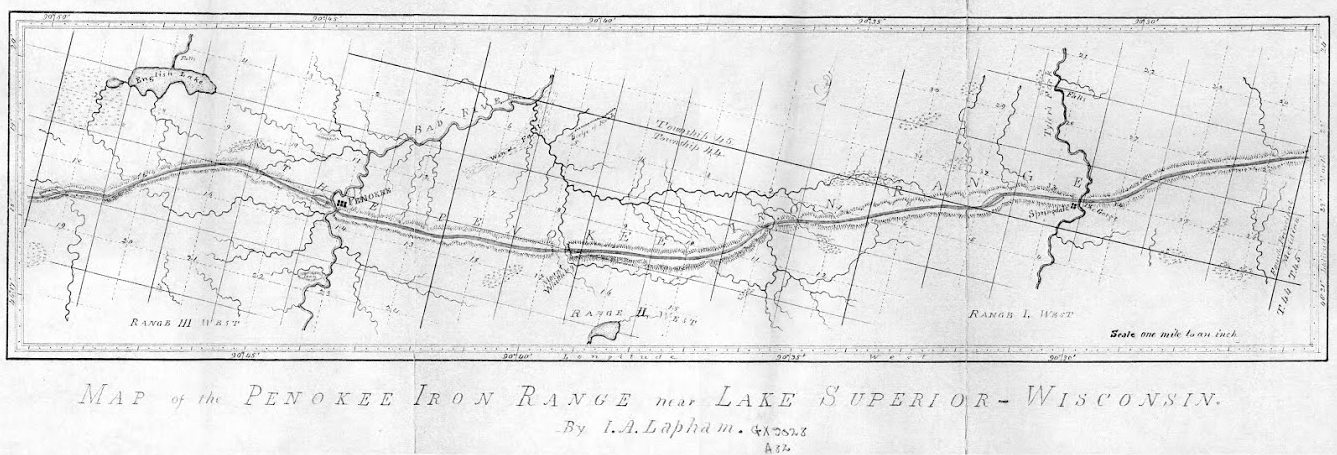
Increase A. Lapham surveyed the Penokee Iron Range on behalf of the Wisconsin & Lake Superior Mining and Smelting Company during 1858.
But what a change have these twenty years brought to the members, as well as the employees of the old company! Of the company, Palmer, Gen. Cutler, H. Hill, Sidebotham, Pixley, J.B.D. Cogswell, Small and Ripley have passed from earth. Lockwood and Harris are in New Orleans; J.F. Hill, J. Cummings and myself in Milwaukee, and Greves in California. Of the others I have no knowledge. Of the employees, Wheelock is upon a farm in Dakota; J.C. Cutler, at his home in Dexter, Maine; Whitcomb is in Milwaukee; Valliant, Stevens and Chase were killed in the late unpleasantness, and H.C. Palmer died in Milwaukee. Of the others I know not.
There are, however, many yet living with whom I became acquainted at that time, in Ashland and vicinity, for whom I have ever cherished the warmest personal friendship. If these sketches and reminiscences of long long ago have interested or amused them, I am glad. The writing of them has brought to mind many scenes and faces, that were almost forgotten, but which are as vivid now as though occurring yesterday. I hope, the coming season to see you all, and talk over old times, and make a trip to the Range over the old trail, every foot of which is accurately mapped in my eye. And now, as my task is done, at least for the present, I will bid the Press readers good-bye, and
Let Brother Whittlesey “spiel” it a while.
About that wonderful siege of Barlile.
J.S. Buck
Milwaukee, Dec. 18, 1877.
