Asaph Whittlesey Incidents: Number VIII
April 20, 2023
Collected & edited by Amorin Mello

Originally published in the April 6, 1878, issue of The Ashland Press. Transcribed with permission from Ashland Narratives by K. Wallin and published in 2013 by Straddle Creek Co.
… continued from Number VII.
Early Recollections of Ashland: Number VIII
by Asaph Whittlesey
We now offer a few comments upon our experience in common, and our appreciation of Doctor Edwin Ellis. I observe first that the inherent modesty of the man left him with next to no thought of himself in his “Early Recollections of Ashland,” and therefore the weightier of the task falling upon me. Had the question been raised “who is Dr. Ellis?” a proper reply would have been “Dr. Ellis is Dr. Ellis.”

In all my acquaintance I find no person more clearly identified than is this man. His manner of shaking hands, the music of his voice, and his unconscious habit of setting his hair on end, belong to no one but the man Edwin Ellis. For near a quarter of a century have I known him in the relationship of neighbor, physician, oarsman, farmer, speculator, preacher, merchant and as one skilled in back gammon, and can testify that he is a man who does with his might whatsoever his hands find to do. Those of us who were known as pre-emptors or town site claimants had occasion to regard the arrival of Dr. Ellis with no little suspicion, as certainly an emergency only would have induced him to make the trip from La Pointe during the most inclement season of the year. I remember well my anxiety to know whether or not he was a married man, and so direct were my inquiries as to this, that seemingly there was no way left but for him to satisfy our curiosity by simply saying yes or no. However we soon discovered that we were only wasting words in pressing the subject, and abandoned all further inquiry regarding it. Is it not strange that so good a man and one possessing so admirable a wife should be found so unwilling to satisfy our inquisitive minds in regard to this matter?
There was still another peculiarity noticeable in the Doctor, and that was his proclivity for secret organizations. He was chosen Chairman of a secret organization having for its object protection to pre-emptors from having their claims jumped, though one writer informs us that in the eye of the law they were all trespassers, – but by this means those holding claims felt a security in being absent from them the greater portion of their time. Perhaps the existence of this organization may explain why there has been so many little acres of early clearings discovered by brother Pratt, in the vicinity of Ashland.
Again, Dr. Ellis is one who thinks for himself, but is ever free to weigh the arguments of others, that he may be convinced of the right, and having formed his conclusion is outspoken, so that no one can mistake his position. Being of a hopeful and cheerful turn of mind, his company is courted. All in all whether as to his fitness for the life of a pioneer or as a neighbor and Christian friend I never knew a better.
I have been with him also in times of very great peril, when seemingly we were destined to a watery grave. But through presence of mind and well directed effort we succeeded in reaching the shore amid a feeling of profound gratitude toward our Great Protector above, for sparing our lives. As it is my intention hereafter to refer briefly to the history of a few of the ladies who first settled in and about Ashland. I will omit any special reference to Mrs. Ellis at this time.
HON. SAMUEL S. VAUGHN
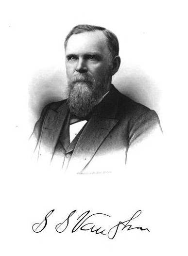
First arrived at La Pointe in 1852. At the time of my arrival there in 1854, I found him running a one horse store in an old frame building, standing in the sand near the present residence of George A. Stahl. So far as I am enabled to bring to mind the succession of events, my first sight of this man was at his own store where I invested in a very poor pocket compass, and this I soon after deposited on the copper range while upon an exploring trip with Ervin Leihy, Esq. Mr. Vaughn, however, claims that he first caught sight of me on the occasion of my aiding Rev. L. H. Wheeler in a social talk with the La Pointe people upon the subject of temperance one Sunday afternoon, in the store of Julias Austrian, Esq.

Reverend
Leonard H Wheeler
The leading man then engaged in the grocery business, as it was called, was one Peter B. Vanderventer, who subsequently left the country at a midnight hour rather than remain and meet a worse doom. Vanderventer was a large sized man and more a hellish countenance, and in exhibition of his bravery at the temperance meeting to which I have referred, he planted himself directly in front of me, and not more than three feet distant, so that I presume he did not mistake my language.

I cannot let slip the opportunity now furnished for informing the public of what seemed to me a rather severe practical joke inflicted upon Vaughn and Vanderventer, as it is too good to be lost, we will mention it right here. It seems that at the time Mr. Austrian made so extended entries of land upon the island, Messrs. Vaughn and Vanderventer discovered that Austrian had failed to enter a fraction shown upon the official plot, as reaching quite a distance into the bay, from what was known as Boyd’s Point and containing some forty acres or more. As La Pointe seemed likely to hold prominence as a business place, they saw the necessity of forthwith securing the tract of land in question. The two therefore suddenly disappeared amid the coldest days of a Lake Superior winter, and footed it under very adverse circumstances through to Willow River, something like one hundred and seventy-five miles, and returned, but yet were quite satisfied to know that they had secured to themselves what they had started for. From this time forward for several years these gentlemen paid their taxes promptly, until they finally employed a surveyor to re-survey and plot their promising possessions. Right here is where they discovered the point of the joke, by being informed that there was not a single foot of their land left, but all and much more had been washed away. Perhaps it was cruel in me to do so, but I could not resist making frequent inquiries as to their real estate.

Section 6 from 1852 GLO PLSS survey of T49N-R3W-4PM showing Boyds Point (now Grants Point) on Madeline Island.
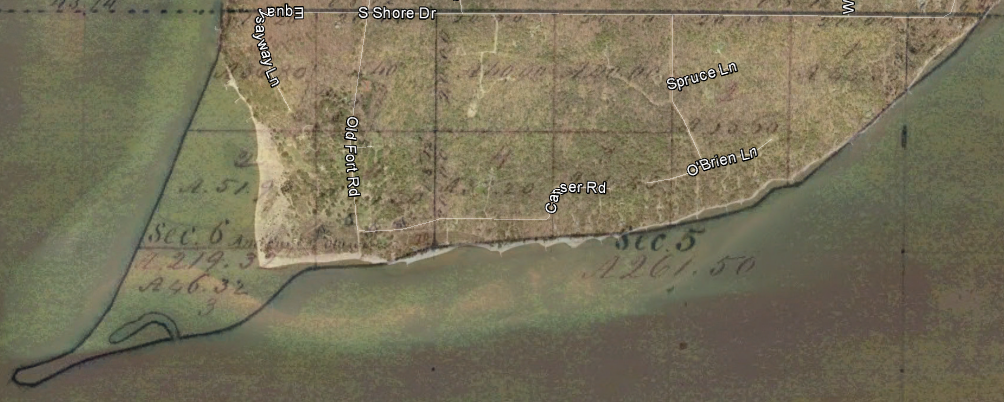
Modern aerial imagery overlay showing Vanderventer & Vaughn’s Lot 3 lost to the sands of time (along with parts of Boyd & Rowley’s Lots 1 & 2).
In 1855 Vaughn removed his stock of goods to a building near where Thomas Stahl, Esq., now resides, where I often shared his bed and board, and it remains a pleasure to me to this day to testify to his qualities as a No. one cook, while biscuits of his make were entitled to special mention. It was a standing rule with him to have a controversy of words with Mr. McElroy, neither being specially noted for the refinement of their language. I think it was during the August term of the Circuit Court in 1860 that Mr. Vaughn and Andrew Tate were admitted to the practice of law before the Hon. S.N. Fuller, Judge of the Eighth Circuit of Wisconsin. It is said that they passed a very creditable examination.
This was the first term of Circuit Court held in the County of La Pointe, Elisha Pike being honored as foreman of the first grand jury convened within the county. Although Mr. Vaughn is but forty-eight years of age he can boast of having held the following positions of trust: Post-master, Justice of the Peace, Chairman of Town and County Boards, also member of the Wisconsin legislature in 1871, (having a constituency of 6,365 souls). In the practice of law his maiden effort was that of procuring papers of divorce in a somewhat renowned case. It is thought that but for the public trust which he held as a Chairman of the School Board he probably would never have known married life, – but as it was so foreordained they accepted the situation, while the people shouted, Amen!
On the arrival of business at Ashland in 1873, Mr. Vaughn removed his family to that place where he once more engaged as trader and forwarding and commission merchant.
To be continued in Number IX…
Edwin Ellis Incidents: Number VII
April 9, 2023
Collected & edited by Amorin Mello
Originally published in the August 25th, 1877, issue of The Ashland Press. Transcribed with permission from Ashland Narratives by K. Wallin and published in 2013 by Straddle Creek Co.
… continued from Number VI.

Plat of Prentice’s Addition to Ashland:
“It is in this addition, that, the Chippewa River and the St. Croix Indian trails reach the Bay.”
My Dear Press: – Recollections of Ashland which should forget to mention Martin Roehm, would leave out a material part – in truth a connecting link in the “chain of events.” He came to the Bay in the summer of 1856 – a hearty industrious young man, not many years from the “Fader Land.” He pre-empted a quarter section of land near the town site – which he still owns. He was not long in discovering the worth and beauty of a comely young widow, who, like himself, had left the “Fader Land” to improve her worldly condition. – After a somewhat lengthy courtship, they were married by “Esquire Bell” in their own home. The ruins of the house may be seen in Prentice’s Addition on the flats between “town” and the mouth of Fish Creek. The bride herself cooked with her own hands the marriage feast, while the guests were gathering. The ceremony was concluded by a grand gallopade, the music being under the direction of that master of the Terpsichorean art, Conrad Goeltz, assisted by his brother Adam, himself a master of the art.

Photograph from obituary of Martin Roehm:
Ashland Daily Press,
April 17, 1898
Martin and his worthy wife still live in Ashland, having witnessed and participated in its varied fortunes for more than twenty years. They may be said to form the connecting link between the Old and New Ashland; for when all others had been, by the force of circumstance, compelled to abandon their homes, they alone remained “monarchs of all they surveyed.” They were in possession of an improved estate in their beautiful valley of Marengo twelve miles from Ashland. This was their favorite winter retreat; while upon the shores of the bay their palaces exceeded in number the residences of the richest kings of the old world. For years they were sovereigns alone, in possession of territory rivaling in extent some of the Kingdoms of Europe.
Their herds of cattle increased year by year and in time patriarchal style, were driven from one part of the vast estate to another, as the necessities of forage might require.
And now, although the revival of Ashland has somewhat restricted the extent of Martin’s possessions, he still owns a valuable herd of cows, and finds a sure source of revenue in the milk supply of Ashland, to the mutual satisfaction of his patrons and himself. His experiments have shown that our soil and climate are adapted to cattle raising and dairy purposes.

Robert Dundas Boyd
Register of Deeds
La Pointe County
Robert D. Boyd, unknown to most of the present generation, came to Ashland in 1855. He was a native of the island of Mackinac – the son of an Indian Agent there stationed. His father was connected by marriage with a distinguished ex-President, to whom he owed his appointment. Rob’t D. as the report was, had, from the effects of a sudden outbreak of passion been guilty of a high crime, and to escape the penalty of the law, had fled to Lake Superior – then almost inaccessible – and safe from invasions of sheriffs and wicked men of that sort. At La Pointe he married a French mixed blood girl by the name of Cadotte, by whom he had several children. Except when under the influence of liquor, his conduct was good and his manner gentlemanly and polite. When partially intoxicated he was thought to be somewhat dangerous if not desperate.

Detail of settlement at Boyd Creek from Augustus Barber’s 1855 survey:
“There is a house in the NE quarter and another in the SE quarter of Section 25.”
He laid claim to a piece of land on the west side of the bay opposite to Ashland, of which a plat was made, to which he gave the name of “Menard,” in memory of the lamented French Jesuit Priest, who, according to tradition, labored for a while at an Indian village then located at this spot, – the point where the old St. Croix Indian trail reached the water of the Great Lake, and which in early years was a well beaten path – but now deserted. No traces of the village are now visible. The storms of nearly two hundred and fifty winters have obliterated all traces, of what from its position, must have been an important point among the Ojibwas of the northwest. According to the tradition, Father Menard left the bay for a missionary tour inland, from which he never returned and no trace of him was ever found.

La Pointe County Deeds Book A Page 577:
Plat of Mesnard
Surveyed, certified, and recorded in 1857 by Edward L. Baker, as power of attorney for Thomas H. Hogan of La Pointe:
“the SE¼ of the SW¼, the SW¼ of the SE¼, and Lot 3 in Section 24, and Lots 1 & 2 and the NE¼ of the NW¼ and west½ half of the NW¼ of Section 25, all in Township 48 North of Range 5 West of the 4th principal meridian of the State of Wisconsin“
Boyd erected a house in 1857 in the western part of Beaser’s Division which still stands, but unoccupied.

Wisconsin Representative Asaph Whittlesey also wrote about this tragedy.
In the latter part of 1857 he became unusually dispirited; his drunken sprees became frequent and long continued; and he was often under arrest for his disorderly and quarrelsome conduct. Finally in January 1858 he fell into a drunken debauch of several days duration. He was then living in the old log cabin on Main Street – Mr. Whittlesey’s first house – with one bachelor companion by the name of Cross. Having passed the night in drunken carousals, in the early morning – irritated by some real or imaginary insult from Cross – he approached the latter with a drawn butcher knife in his hand, holding it up in a threatening manner, as if about to strike. Cross drew a revolver and fired – two balls passed into the chest – one entering the heart. Boyd fell and in five minutes had breathed his last. This tragic event produced a profound sensation in our little community. A coroner’s inquest was held by Asaph Whittlesey, then a justice of the peace, – and although the evidence seemed to show that Cross might have retreated and saved himself without taking Boyd’s life, still Cross was judged by the jury to have acted in self-defense and was acquitted, Boyd’s known desperate character doubtless contributed to this result.
Boyd’s wife had died some years before, and several children were left orphans; and the writer will always carry in his mind the affecting scene as the little daughter three years old was held up in the arms of Mrs. Angus to take a last view of, and imprint a last kiss on the cold brow of her only natural protector. But God – who is ever the Father of the fatherless, – took care of the orphans, and they are now grown up to manhood and womanhood, and twenty years have effaced from most the memory of this sad event.
To be continued in Number VIII…
Asaph Whittlesey Incidents: Number VII
March 27, 2023
Collected & edited by Amorin Mello
Originally published in the March 30, 1878, issue of The Ashland Press. Transcribed with permission from Ashland Narratives by K. Wallin and published in 2013 by Straddle Creek Co.
… continued from Number VI.
Early Recollections of Ashland: Number VII
by Asaph Whittlesey
—
I am now brought to the more difficult task of making suitable mention of those who were associated with me as original proprietors of the place, some of whom have already passed the bounds of time.
Charles Whittlesey whote about Martin Beaser working for the Algonquin Company of Detroit during 1845 in Two Months In The Copper Range:
“… Martin, a sailor just from the whaling grounds of the Northwest Coast …”
Martin Beaser, was a man of much more than ordinary ability. I am not informed as to his opportunities for education in early life, but judge that they were somewhat limited, while his individual experiences were wide spread. Nothing ever passed his notice, nor would he abandon a subject until he fully comprehended it. In form he was compact, and as he was capable of great endurance, no obstacle in his life seemed too great for him to surmount. A look at his extended library will itself evince his inclination for the best of literature. – When I first met him (in August, 1854,) I took him to be something like forty-two or forty-three years of age. I had often heard his name mentioned by my brother Charles, as having been associated with him during the season of 1846 in his geological explorations of the Lake region for the General Government in connection with Dr. Houghton, – but we had never met until in August, 1854. Mr. Beaser had been very successful in business during the “palmy days” of Ontonagon, and was abundantly able to meet the expense of opening the town site of Ashland.
I think Mrs. Beaser first made Ashland her home in 1856. On the 7th of June, 1855, there landed a large sized mackinaw at Ashland, (the boat being named Ashland,) containing the following persons:
~ Edwin Ellis Incidents: Part III
Martin Beaser, Captain and owner; G. L. Brunschweiler, civil engineer and draftsman, Charles Day, J. S. Norton, Jonas Whitney, a man by the name of Weiber and a Menominie Half Breed from Green Bay. This event was a signal for an onward movement, and during that season the town was greatly improved.
I think portions of the boat named may yet be seen near the base of Durfee’s Dock in Ashland. An amusing incident took place during this trip from Ontonagon which is deserving of notice. The boat, besides passengers, was heavily loaded with provisions, groceries, &c., so that the passengers were somewhat cramped for room. As the wind was fair the party kept under way all night long, reaching the mouth of Bad River about day break. Brunschweiler, who was a very passionate man, had passed the night in a very uncomfortable manner, on account of a box of saleratus taking up the room he needed for his comfort. He had evidently felt it as a very great annoyance to him the live-long night, and he could restrain himself no longer. He therefore, with an oath, pitches overboard the box of saleratus, and in doing so lost a very valuable meerschaum pipe belonging to himself, which created a roar of laughter from the party, Mr. Beaser himself joining therein. I will only add regarding our association with Mr. Beaser and his family, that we found them to be most excellent, and accommodating neighbors.

Detail of Ashland and Bay City from inset map on Plat of Prentice’s Addition to Ashland circa late 1850s or early 1860s.
~ Wisconsin Historical Society
Mr. Beaser was drowned in Ashland Bay November 4th, 1866, having evidently reached near the center of the bay before falling overboard. The wind was in the north east so that his boat landed a little south of Whittlesey’s landing at the head of the bay. – When the boat was found the sail was set and the boat contained the purchases he had made at Bayfield. Immediate search was made for his body, but it was not found until the following spring, when a Half Breed first discovered it near the mouth of Boyd’s Creek on the west side of the bay. The citizens of Bayfield gave the body a suitable burial, first at Bayfield, and subsequently it was removed to the Protestant burying ground on La Pointe Island.
Mr. Beaser was noted for his unusual good temper, and often indulged in practical jokes. At one time he was inquired of as to the provisions made for the poor in the town of Ashland. His answer was “we starve them out.”
BRIEF SKETCH OF THE LIFE OF GEORGE KILBOURN, JR.
While I lack much in his history to enable me to be as precise in my statements regarding him as I would like to be, I am, nevertheless, in a general way, fully acquainted with his entire history. Long before I was born, George Kilbourn, Senior, (father to the subject of this notice,) purchased a farm in my native town in Ohio, and here it was that George, Jr., first displayed his qualities as an axeman, evincing the grudge he steadfastly bore towards growing timber. Even before attaining his majority George, Jr., had cleared the principle portion of his father’s farm, and after his marriage he removed to Hudson, Ohio, where he purchased for himself a heavily timbered tract of 160 acres, the clearing of which afforded him the greatest comfort. Unfortunately he married very unhappily, and in due time his wife and children virtually drove him from his own home. I chanced to meet him something like two weeks previous to my leaving Ohio for this place, and informed him of the time I intended to stay, and bade him goodbye. But on my passing through Hudson on the cars for Cleveland as the appointed time, Mr. Kilbourn came on board the train and informed me he had decided to accompany me on my trip to Lake Superior, that he could not endure it to remain at home any longer. This was, in brief, his history up to the time of our leaving Ohio in 1854. – The Kilbourns are known as a long lived race, while the “old stocks” were all hard workers. George, Jr., (better known as Uncle George,) was not far from fifty-five years of age when he first came to this country. He died suddenly in July, 1870, while visiting a daughter then living at East Hartford, Michigan, being not far from seventy-one years of age. His father and mother lived together at Hudson, Ohio, quite a number of years after Uncle George left Ohio, and lived to pass something over seventy years together in married life.
~ Edwin Ellis Incidents: Part IV
Had it not been for Uncle George’s proclivity and skill in clearing land, the clearings in and about original Ashland would have been much more limited than they are now. I have often known him to chop all day long, and during bright nights he not unfrequently left his bed and put in from one third to one half of the night felling timber. He often requested me, in case I out-lived him, to bury a good axe and grind stone with him. He had also another peculiarity belonging strictly to himself and that was a ravenous appetite, and usually ate the most and worked the hardest during his sick days. At one time when he was boarding with Conrad Goeltz, he started out just at day break to get to his chopping, and as he passed through the dining room caught sight of extended preparations upon the table which had been specially arranged the evening previous for a party of six persons who had ordered their breakfast at an early hour, but without giving it a thought Uncle George placed himself outside of all there was in sight, and poor Conrad has not to this day forgotten how infernally mad he felt when he found out how he had been victimized. I will add further that Uncle George called this a lunch only, and was on hand for breakfast at the usual hour. We all regarded him as being a hardworking, conscientious and strictly honest man. The settlers, whites, half breeds or Indians all addressed him by the familiar title of Uncle George.
To be continued in Number VIII…
Asaph Whittlesey Incidents: Number VI
April 17, 2019
By Amorin Mello
Originally published in the March 23, 1878, issue of The Ashland Press. Transcribed with permission from Ashland Narratives by K. Wallin and published in 2013 by Straddle Creek Co.
… continued from Number V.
Early Recollections of Ashland: Number VI
by Asaph Whittlesey
—
During 1856 the steamers Lady Elgin, Illinois, and Superior landed freight and passengers upon a steamboat dock constructed at Bay City, now Ellis division of Ashland.

1860 photograph of the sidewheel steamer Lady Elgin.
~ Ship-Wrecks.net
Ashland’s first saloon was opened by James Whitney in June 1856, and during the same month the first store was opened by Martin Beaser, on the corner of block one hundred and one.
The patent to Ashland, issued by the United States, bears the date June 23rd, 1862.
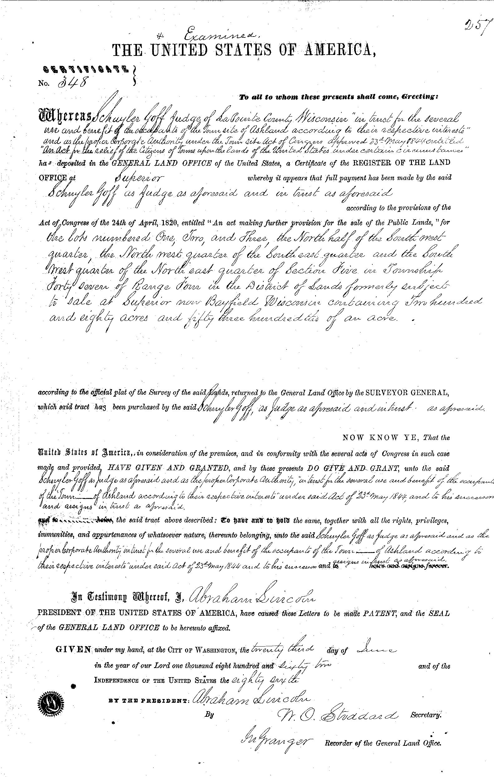
Land patent for the town site of Ashland issued by President Abraham Lincoln on June 23rd, 1862 to Schuyler Goff:
“The contract between the three was, that Mr. Whittlesey and Mr. Kilborn were to receive each an eighth interest in the land, while the residue was to go to Mr. Beaser. The patent for the land was issued to Schuyler Goff, as county Judge of La Pointe county, Wisconsin, who was the trustee for the three men, under the law then governing the location of town sites.”
~ Biographic sketch of Martin Beaser
OF THE OPENING OF ROADS IN THE EARLY DAYS OF ASHLAND.
In reporting upon this subject it is very possible that our town authorities of the present day may be put somewhat to the blush by the manner in which these and other like improvements were made. And I will guarantee the re-election of any Town Board, or other town officer who will carry out the program of former days for the opening of roads, which was simply this:
Whenever a road was needed such men as Edwin Elllis, Martin Beaser, George Kilbourn and myself, (I came near overlooking the latter,) and others who mainly volunteered their work, shouldered their axes and served in person until roads contemplated were completed. There was also this peculiarity attached to this class of individuals; they did not hang about the steps of the town house the balance of the year for the purpose of getting bills audited for work done upon the highways. It was in this manner that the road leading to Odanah and also that leading south to White River Falls were first opened. Even Indians partook of the same spirit in volunteering their labor, as Aid-de-camp to their Great Leader, Rev. L. H. Wheeler.
I have no doubt Dr. Ellis still bears in mind how the woods at Bear Trap were made to echo the yells of the Indians as they collided with the party from Ashland on the very day agreed upon, and I think I may safely say that the citizens of Odanah and of Ashland looked upon the opening of this road as a momentous event, and one which cemented us together even more firmly as friends and neighbors, though I have no doubt many of my readers will stand ready to declare that the foot race existed not very far back.
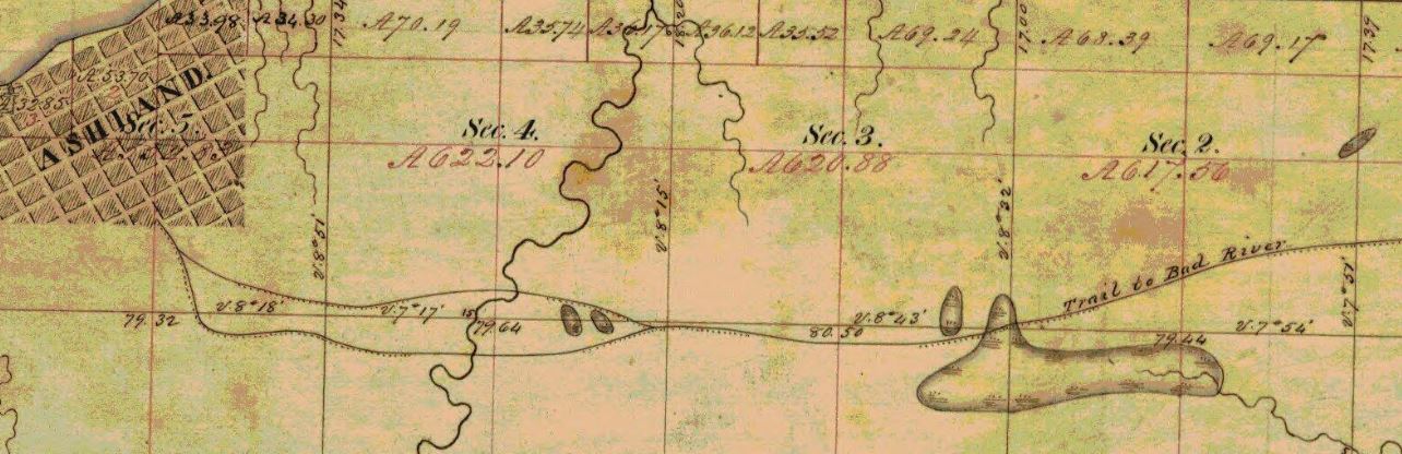
Detail of trail from Ashland to Bad River on Barbers’ survey during the Summer of 1855.
We wore good countenances, slept well nights, and paid one hundred cents on the dollar of our obligations. We were not ashamed to eat salt pork (those of us who could get it,) while our faithful wives vied with each other in the different styles of cooking this staple article of diet.
Next to this comes the everlasting pancake, without which neither town site nor pre-emptions could be legally established.
~ History of the Soo Line by James Lyden, chapter 9.
~ History of Northern Wisconsin by the Western Historical Company, 1881, page 82.
On the second day of June, 1877, I had the honor of driving the last spike, which took place at Chippewa Station, amid the shoutings of a large assemblage of people, including laborers upon the road, and in a few moments thereafter the first train from Milwaukee passed over the road on its way to Ashland, amid great rejoicing and demonstrations of joy over the victory won. At Ashland also the excitement became intense and though it was late on a Saturday evening on which our train reached the town, the illumination of the place brought to our view a field of faces, crazy with excitement over the event they were celebration. As for myself, I confess I felt very much like saying, “Now let thy servant depart in peace.” No longer were we to be informed of what was to be done, but we now knew it to be actually accomplished, and the Wisconsin Central Railroad remained a standing monument to the good name of Gardner Colby, Charles L. Colby and E. B. Phillips, all other efforts being secondary to that of these individuals. I have in my possession a map of this section of country, published by Charles C. Tucker in 1858, on which he laid down an imaginary line of railroad as being likely to be constructed from Madison via Portage and Stevens Point to Ashland, and strange to say it lays down the precise route of the Wisconsin Central Railroad, the very first to be constructed.
Having received by our last mail an important official statement from the Railroad Commissioner for the State of Wisconsin, I will insert the same here rather than to fail to have it published:
He says “the number of miles of railroad now constructed within the State of Wisconsin is two thousand six hundred and fifty-nine and 6-100, while there are seventy-one thousand seven hundred and fifty-nine miles of railroad now operated within the United States, with a capital and debt amounting to four billion six hundred and fifty-eight million two hundred and eight thousand six hundred and thirty dollars.”
STATISTICS IN GENERAL
In furnishing these I desire specially to acknowledge the obligation I am under to Mrs. James Wilson, for granting me access to early records of the place kept by Martin Beaser, Esq., though I find some discrepancies between his record and my own, which I think can be explained by the fact that he did not commence his record until some years after the first settlement of the place, and made it from memory along. For instance he says “the town site of Ashland was located by Martin Beaser, Asaph Whittlesey and George Kilbourn in August, 1854,” whereas Mr. Kilbourn and myself commenced the settlement of the town site July 5th, while Mr. Beaser first visited the place in August when he became an owner therein, the town site being from this time forward owned three fourths by Martin Beaser and one eighth each Kilbourn and Whittlesey.
Again Mr. Beaser’s record states that “the first house was built by Asaph Whittlesey in October, 1854, and was twenty by thirty feet square,” while the fact is I had erected two cabins upon the town site previous to the erection of this one and had lived in them.
Following cabin built by Kilbourn and Whittlesey, foundation laid July 5th, 1854, was twelve by fourteen feet square and was erected on lot number two in block one hundred and five. The foundation to the second cabin built was laid by Kilbourn and Whittlesey Sept. 9th 1854. This cabin was thirteen by fifteen feet square and was erected on lot five of block six. The outline of this building may still be traced. – The third house erected was that erected by Asaph Whittlesey on lot six in block six and was twenty by thirty feet square and this building constituted the residence of the Whittlesey family until the fall of 1857 when I removed to what is known as the Tompkins house on lots five and six in block three. I have in my possession very correct sketches of the first three cabins built, which I hope eventually to have lithographed for preservation. The fourth house was erected by Conrad Goeltz. The fifth house by Martin Beaser. The sixth house by Myron Tompkins. The seventh house by Lawrence Farley. The eighth house by Charles Malmet. The ninth house by Anthony Fisher. The tenth house by Frederick Bauman. Beyond this I am unable to give the order in which buildings were erected.
Conrad and Adam Goeltz first arrived at Ashland in March, 1855, and were employed by me in chopping and delivering cord wood upon the bay shore. As we were without a team we improvised one by harnessing these two Dutchmen and myself in the form of a spike team to a large sized hand-sled with which we banked twenty cords of wood per day.
P.S. – Adam had it twenty-two cords per day, but I think we had better throw off the two cords and try to save our reputation for veracity.
The first chickens brought into town were those brought by A. Whittlesey from Ohio in 1854.
John Beck butchered the first hogs in town, though he left a few which he did not butcher.
Martin Beaser brought the first yoke of oxen, and in 1855 raised about two hundred bushels of potatoes upon the town site. On the third of December, 1855, the schooner Algonquin landed at Ashland two hundred and twenty-five barrels of freight, seventy-five thousand feet of lumber and a yoke of oxen.
Ashland Bay froze over Dec. 7th, 1855. The two first steamboat docks were built during the winter of 1855-6, one by Martin Beaser at the foot of Main Street and one by the Bay City Company. These were carried away by the ice May 1st, 1856.
To be continued in Number VII…
Wheeler Papers: Bad River’s Missing Creek
October 3, 2018
By Amorin Mello

This is one of several posts on Chequamegon History featuring the original U.S. General Land Office surveys of the La Pointe (Bad River) Indian Reservation. An earlier post, An Old Indian Settler, features a contentious memoir from Joseph Stoddard contemplating his experiences as a young man working on the U.S. General Land Office’s crew surveying the original boundaries of the Reservation. In his memoir from 1937, Stoddard asserted the following testimony:

Bad River Headman
Joseph Stoddard
“As a Christian, I dislike to say that the field representatives of the United States were grafters and crooks, but the stories related about unfulfilled treaties, stipulations entirely ignored, and many other things that the Indians have just cause to complain about, seem to bear out my impressions in this respect.”
In the winter of 1854 a general survey was made of the Bad River Indian Reservation.
[…]
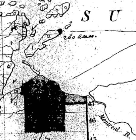
It did not take very long to run the original boundary line of the reservation. There was a crew of surveyors working on the west side, within the limits of the present city of Ashland, and we were on the east side. The point of beginning was at a creek called by the Indians Ke-che-se-be-we-she (large creek), which is located east of Grave Yard Creek. The figure of a human being was carved on a large cedar tree, which was allowed to stand as one of the corner posts of the original boundary lines of the Bad River Reservation.
After the boundary line was established, the head surveyor hastened to Washington, stating that they needed the minutes describing the boundary for insertion in the treaty of 1854.
We kept on working. We next took up the township lines, then the section lines, and lastly the quarter lines. It took several years to complete the survey. As I grew older in age and experience, I learned to read a little, and when I ready the printed treaty, I learned to my surprise and chagrin that the description given in that treaty was different from the minutes submitted as the original survey. The Indians today contend that the treaty description of the boundary is not in accord with the description of the boundary lines established by our crew, and this has always been a bone of contention between the Bad River Band and the government of the United States.
The mouth of Ke-che-se-be-we-she Creek a.k.a. the townsite location of Ironton is featured in our Barber Papers and Penokee Survey Incidents. Today this location is known as the mouth of Oronto Creek at Saxon Harbor in Iron County, Wisconsin. The townsite of Ironton was formed at Ke-che-se-be-we-she Creek by a group of land speculators in the years immediately following the 1854 Treaty of La Pointe. Some of these speculators include the Barber Brothers, who were U.S. Deputy Surveyors surveying the Reservation on behalf of the U.S. General Land Office. It appears that this was a conflict of interest and violation of federal trust responsibility to the La Pointe Band of Lake Superior Chippewa.
Missionary stationed at Bad River
Reverend Leonard H. Wheeler
This post attempts to correlate historical evidence to Stoddard’s memoir about the mouth of Ke-che-se-be-we-she Creek being a boundary corner of the Bad River Indian Reservation. The following is a reproduction of a petition draft from Reverend Leondard Wheeler’s papers, who often kept copies of important documents that he was involved with. Wheeler is a reliable source of evidence as he established a mission at Odanah in the 1840s and was intimately familiar with the Treaty and how the Reservation was to be surveyed accordingly.
Wheeler drafted this petition six years after the Treaty occurred; this petition was drafted more than seventy-five years earlier than when Stoddard’s memoir of the same important matter was recorded. The length of time between Wheeler’s petition draft and Stoddard’s memoir demonstrates how long this was (and continued to be) a matter of great contemplation and consternation for the Tribe. Without further ado, we present Wheeler’s draft petition below:
A petition draft selected from the
Wheeler Family Papers:
Folder 16 of Box 3; Treaty of 1854, 1854-1861.
To Hon. C W Thompson
Genl Supt of Indian affair, St Paul, Min-
and Hon L E Webb,
Indian Agent for the Chippewas of Lake Superior
March 30th, 1855 map from the U.S. General Land Office of lands to be withheld from sale for the La Pointe (Bad River) Reservation from the National Archives Microfilm Publications; Microcopy No. 27; Roll 16; Volume 16. The northeast corner of the Reservation along Lake Superior is accurately located at the mouth of Ke-che-se-be-we-she Creek (not labeled) on this map.
The undersigned persons connected with the Odanah Mission, upon the Bad River Reservation, and also a portion of those Chiefs who were present and signed the Treaty of Sept 30th, AD 1854, would most respectfully call your attention to a few Statements affecting the interests of the Indians within the limits of the Lake Superior Agency, with a view to soliciting from you such action as will speedily see one to the several Indian Bands named, all of the benefits guaranteed to them by treaty stipulation.
Under the Treaty concluded at La Pointe Sept 30th, 1854 the United States set apart a tract of Land as a Reservation “for the La Pointe Band and such other Indians as may see fit to settle with them” bounded as follows.
a.k.a.
Ke-che-se-be-we-she
“Ke-che” (Gichi) refers to big, or large.
“se-be” (ziibi) refers to a river.
“we-she” (wishe) refers to rivulets.
Source: Gidakiiminaan Atlas by the Great Lakes Indian Fish & Wildlife Commission
“Beginning on the South shore of Lake Superior a few miles west of Montreal River at the mouth of a creek called by the Indians Ke-she-se-be-we-she, running thence South &c.”

Detail of the Bad River Reservation from GLIFWC’s Gidakiiminaan Atlas. This map clearly shows that the northeast boundary of Bad River Reservation is not located at the true location of Ke-che-se-be-we-she Creek in accordance with the 1854 Treaty. Red highlights added for emphasis of discrepancies.
Your petioners would represent that at the time of the wording of this particular portion of the Treaty, the commissioner on the part of the United States inquired the number of miles between the mouth of the Montreal River and the mouth of the creek referred to, in reply to which, the Indians said “they had no knowledge of distance by miles” and therefore the commissioner assumed the language of “a few miles west of Montreal River” as discriptive of the creek in mind. This however, upon actual examination of the ground, does to the Band the greatest injustice, as the mouth of the creek to which the Indians referred at the time is even less than one mile west of the mouth of the Montreal.*
*This creek at the time was refered to as having “Deep water inside the Bar” sufficient for Boats which is definitive of the creek still claimed as the starting point, and is not descriptive of the most westerly creek.
But White men, whose interests are adverse to those of the Indians now demand that the Reservation boundary commence at an insignificant and at times scarcely visible creek some considerable distance west of the one referred to in the Treaty, which would lessen the aggregate of the Reservation from 3 to 4000 acres.
Your petioners, have for years, desired and solicited a settlement of the matter, both for the good of the Indians and of the Whites, but from lack of interest the administrations in power have paid no attention to our appeals, as is also true of other matters to which we now call your attention.
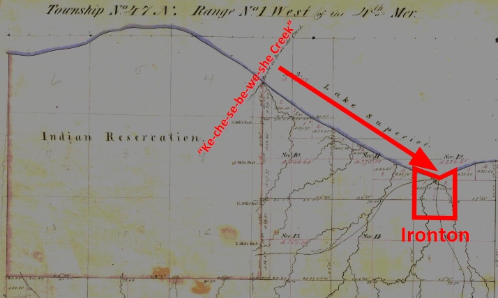
1861 resurvey of Township 47 North of Range 1 West by Elisha S. Norris for the General Land Office relocating Bad River Reservation’s northeast boundary. Ke-che-se-be-we-she Creek was relocated to what is now Graveyard Creek instead of its true location at the Barber Brother’s Ironton townsite location. Red highlights added for emphasis of discrepancies.
As many heads of families now wish to select (within the portion of Town 47 North of Range 1 West belonging to the Reservation the 80 acre tract assigned to them) we desire that the Eastern Boundary of the Reservation be immediately established so that the subdivisions may be made and and land selected.
Your petioners would further [represent?] that under the 3d Section of the 2nd article of the Treaty referred to the Lac De Flabeau, and Lac Court Orelles Bands are entitled to Reservations each equal to 3 Townships, (See article 3d of Treaty. These Reservations have never been run out, none have any subdivisions been made.) which also were to be subdivided into 80 acre Tracts.
Article 4th promises to furnish each of the Reservations with a Blacksmith and assistant with the usual amount of Stock, where as the Lac De Flambeau Band have never yet had a Blacksmith, though they have repeatedly asked for one.
Wisconsin State Representative
and co-founder of Ashland
Asaph Whittlesey
As the matters have referred to one of vital importance to these several Bands of Indians, we earnestly hope that you will give your influence towards securing to them, all of the benefits named in the Treaty and as the subject named will demand labor entirely outside of the ordinary duties of an Indian Agent, and as it will be important for some one to visit the Reservations Inland, so as to be able to report intelligently upon the actual State of Things, we respectfully suggest that Mr Asaph Whittlesey be specially commissioned (provided you approve of the plan and you regard him as a suitable person to act) to attend to the taking of the necessary depositions and to present these claims, with the necessary maps and Statistics, before the Commissioner of Indian Affairs at Washington, the expense of which must of necessity, be met by the Indian Department.
Mr Whittlesey was present at the making of the Treaty to which we refer, and is well acquainted with the wants of the Indians and with what they of right can claim, and in him we have full confidence.
In addition to the points herein named should you favor this commission, we would ask him to attend to other matters affecting the Indians, upon which we will be glad to confer with you at a proper time.
The undersigned L H Wheeler and Henry Blatchford have no hesitency in saying that the representations here made are full in accordance with their understanding of the Treaty, at the time it was drawn up, they being then present and the latter being one of the Interpreters at the time employed by the General Government.
Most Respectfully Yours
Dated Odanah Wis July 1861
Names of those connected with the Odanah Mission
[None identified on this draft petition]
Names of Chiefs who were signers to the Treaty of Sept 30th 1854
[None identified on this draft petition]
Although this draft was not signed by Wheeler or Blatchford, or by the tribal leadership that they appear to be assisting, Chequamegon History believes it is possible that a signed original copy of this petition may still be found somewhere in national archives if it still exists.
Asaph Whittlesey Incidents: Number V
October 2, 2018
By Amorin Mello
Originally published in the March 16, 1878, issue of The Ashland Press. Transcribed with permission from Ashland Narratives by K. Wallin and published in 2013 by Straddle Creek Co.
… continued from Number IV.
Early Recollections of Ashland: Number V
by Asaph Whittlesey
—
FIRST ELECTION IN THE TOWN OF BAY PORT.
The order of the County Board creating the Town of Bay Port was made March 11th, 1856, and the store of Schuyler Goff in Bay City was designated as the place for holding the first election for town officers, the election to be held April 1st, 1856.
The journal containing this order (which was in pamphlet form,) was destroyed by fire at the burning of the Webb House in Bayfield, Wis., June 4th, 1874.

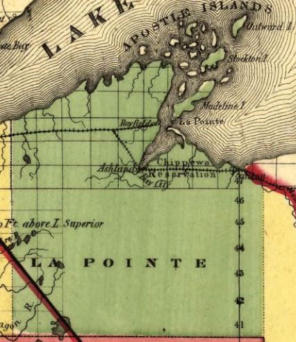
Detail of La Pointe County from a map of Wisconsin published by J. H. Colton & Co., New York, 1856.
~ David Rumsey Map Collection
The new town comprised all that portion of La Pointe county, Wis., laying south of the north line of town 48 north, in all over sixty eight townships, including the Bad River Indian Reservation, which was, on the 8th of Nov. 1859, made a precinct by itself.
At the election held April 1, 1856, there were twenty-four votes cast, resulting as follows: For Chairman of Town Board, Schuyler Goff; remaining member of Town Board, J. T. Welton and Asaph Whittlesey. Schuyler Goff, Chairman elect, was the first to qualify, his oath of office being administered by Asaph Whittlesey, Justice of the Peace.
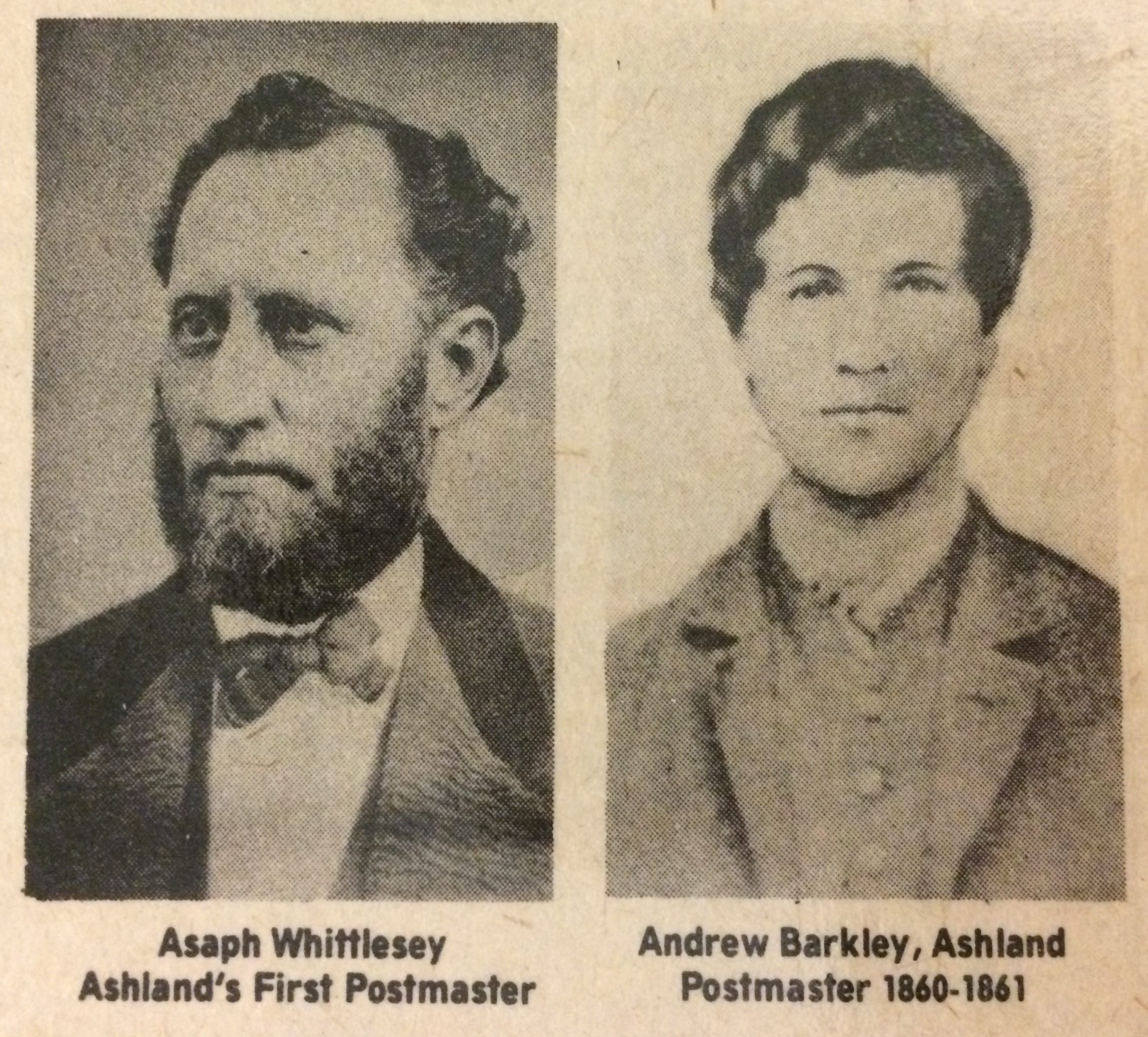
Photographs of Asaph Whittlesey and Andrew J Barkley reproduced from the Ashland Daily Press – national bicentennial issue (July 1976).
The annual statement made in April, 1857, showed the outstanding indebtedness of the town to be $25.00. The report submitted in April, 1858, showed highway orders issued during the year previous $57.50. Town indebtedness in April, 1858, was $22.75, and at that election there was levied the sum of $195.59, to meet the town expenses for the ensuing year. The following were the bills allowed by the town meeting in April, 1857: The first allowed was the bill of Edwin Ellis for $9.25; 2nd, J. T. Welton, $9.00; 3rd, A. J. Barkley, $5.50. In those days no bills were allowed nor orders drawn to cover them until the same had been approved at the town meeting. They had not yet learned to audit accounts with the marvelous rapidity known to Town Boards of more recent dates. However the Town Clerk comprehending this groans out as follows: “The vaults of the Treasuring are declared empty, and the servants of the town will therefore be obliged to wait for their pay until money shall be assessed and collected.”
Again. By referring to the Records of La Pointe, (being two years previous to the organization of the town of Bay Port,) Charles Pulcifer, acting as town treasurer, certifies that “the only unpaid personal property tax was that of J. W. Bell, amounting to $33.00, and that he was unable to find any goods on chattels belonging to the said Bell to enable him to collect the tax.
The assessment for 1857 made by Edwin Ellis for which allowance of $6.00 was made. At the annual town meeting in 1858 the first bill acted upon was that of Asaph Whittlesey, Superintendent of schools, amounting to 75 cents, though it was not allowed as they claimed it was out of their jurisdiction. – Bills of Edwin Ellis and Rev. L. H. Wheeler, for work done on the highway was rejected. It was resolved at this meeting that thereafter one shilling per hour be allowed for work on the highway.
OUR EXPERIENCE IN RAILROAD MATTERS.
Detail of La Pointe County from a map of Wisconsin published by The Milwaukee & Horicon Rail Road, 1857.
~ Library of Congress
We often fall into the habit of complaining because things move so slow, and especially is this system of fault finding associated with the delays usually experienced in the construction of railroads in the west. However, upon reflecting I find that my time in life embraces the entire history of railroads in the United States, nearly the first roads put into operation, (if not the very first,) were one from Baltimore to Washington and one from Albany to Schenectady, N.Y., over which it was my good fortune to pass before reaching my majority, and about the time I became of age, it was my fortune to ride over not only the first railroad constructed in Illinois, bu the first built in the Mississippi valley, to wit: from Meredosia, on the Illinois River, to Springfield, a distance of forty miles, which, in its day, was regarded something not to be sneezed at, as the roads I have named were at least suggestions of the great systems of roads today. Governor Donenn, of Illinois, in his message of 1835-6, referred in the most glowing language to the triumph of the canal boat and the locomotive in almost annihilating time, burden, and space in other parts of the country and wanted to known if the Patriot bosoms of Illinois did not beat high to emulate such examples of internal improvement.
There were at different times two locomotive run over the Illinois roads mentioned, and finally mule power was resorted to. – The following year an Internal Improvement Bill was passed and roads were laid out for every quarter of the State, the results of which was to bankrupt the State. But the movement was not without its advantages, as by the following spring the forty miles reaching to Springfield was graded and ready for the track to be laid. The track was laid by putting down a piece of square timber called a mud sill on the top of which cross ties were laid. On these a wooden rail was laid and flat bars of iron were spiked on the top of the rail. These bars were tow and one half inches wide and one inch thick, and upon this track turned the wheel of the first locomotive brought into the Mississippi valley.
It might be called a curious contrivance, since the locomotive was simply a piece of clumsiness and of no practical use, the driving wheels being only about two and a half feet in diameter, and the engine itself having very little power. This road finally passed out of the hands of the State for a consideration of $100,000, in State indebtedness, while the actual cost to the State was $1,000,000.
I have dwelt somewhat long and in general terms upon the subject of railroads in the United States, to show to my readers that there has been no want of energy in their construction, but on the contrary the rapidity with which they have penetrated the wilderness is simply marvelous, converting Indian wilds into prosperous cities or fields of golden harvest. My own connection with the building of railroads dates no farther back then the time of my landing here in 1854, since which, I have in my way left no stone unturned looking to the introduction of railroads into this country. I was for a time a director in the St. Croix and Lake Superior Railroad Company, during which (but for the complications of the road,) Gardner Colby would have undertaken its construction instead of turning his attention to the Wisconsin Central Railroad.
To be continued in Number VI…
Asaph Whittlesey Incidents: Number IV
April 11, 2017
By Amorin Mello

Originally published in the March 9th, 1878, issue of The Ashland Press. Transcribed with permission from Ashland Narratives by K. Wallin and published in 2013 by Straddle Creek Co.
… continued from Number III.
Early Recollections of Ashland: Number IV
by Asaph Whittlesey
In our last number we referred to “the most aristocratic house” with lumber floors, etc. Though it was the third cabin built upon the “town site,” it was in reality the first cabin built, designed as a permanent residence. The foundation logs of this house were laid Sept. 20th, 1854. The record made by Martin Beaser, (evidently made from recollection,) calls this the first building erected, (giving the size of it,) whereas we had lived in two buildings previous to the building of this one.
Rev. Leonard Hemenway Wheeler
~ In Unnamed Wisconsin by Silas Chapman, 1895, cover image.
The “Whittlesey Post Office” was kept therein from the date of its establishment, March 12th, 1855 to Nov. 1858. The first dancing done within the “town site” was in this house in Nov. 1854, and during the winter religious services were held therein by Rev. L. H. Wheeler, of the Odanah Mission. It was the birthplace of Delia Elizabeth, second daughter to Mr. And Mrs. Asaph Whittlesey, born May 21st, 1856, being the first American child born within the limits of the “town site.” The first celebration of the Fourth of July was held in this house July 4th, 1855, further reference to which will hereafter be made. The first general election of county officers in the county of Ashland, was held in this building Nov. 4th, 1856, at which time Samuel S. Vaughn received eleven votes for the office of County Clerk, and M. H. Mandelbaum receive twelve. Francis McElroy was elected District Attorney and Asaph Whittlesey County Judge. It was in this house that Robert D. Boyd was shot and instantly killed by Henry Cross, January 10th, 1858, for which a verdict of justifiable homicide was rendered at an inquest, held by Asaph Whittlesey, Justice of the Peace, acting as Coroner.
ARRIVAL OF THE SECOND FEMALE UPON THE TOWN SITE.
Mr. and Mrs. John P. T. Haskell, with their family, parents of Mrs. Whittlesey, made a landing at Ashland, Nov. 2nd, 1854, and made their home with us during the winter following. In the early spring they made a home of their own in a cabin located upon the site of the present residence of G. M. Willis, Esq., a little to the east of Vaughn’s Dock, in Vaughn’s addition to Ashland, which was originally known as Haskell’s pre-emption claim. Mr. Haskell and family remained in the country only a single year, when they returned to Illinois, where Mr. Haskell died in 1873. Mrs. Haskell is still living and is unusually active for one of her age.
I next call your attention to the
FIRST CELEBRATION OF THE 4TH OF JULY
upon the “town site” July 4th, 1855.
Under an understanding had between Mr. and Mrs. Austin Corser and Mr. And Mrs. John Corser, (then living at Fish Creek,) and being the owners of the only cows nearer than Odanah, an agreement was made whereby the Corsers were to furnish milk, while Mrs. Haskell and Mrs. Whittlesey, (then living in the log house still visible on lot 6, of block 6,) were to do the necessary cooking in the celebrated “mud oven” attached thereto, marvelous for its baking capacity and for the quality of its production.
On the day referred to, the Declaration of Independence was read by Asaph Whittlesey, and this with the delivery of an oration by A. W. Burt, with singing and amusements, constituted the first public celebration of the 4th of July in the history of Ashland. The exercises were had at Whittlesey’s house in the after part of the day, and extended late in the evening, when music and dancing were added to the festivities of the day. The ladies present were Mrs. Haskell, Mrs. Whittlesey, the two Mrs. Corsers and Mrs. Farley. The gentlemen present were J. P. T. Haskell, George Kilborn, Lawrence Farley, Austin and John Corser, Asaph Whittlsey, A. W. Burt, A. J. Barckley, Adam Goeltz, John Donaldson, Conrad Goeltz, Andrew Scobie, and Duncan Sinclaire. The children present were Eugenia E. Whittlesey, (less than three years old,) George, son of Mr. and Mrs. Austin Corser, also a child of Mr. and Mrs. John Corser and William, John Joseph and Hattie Haskell, children and Mr. and Mrs. J. P. T. Haskell.
I shall never forget Mrs. Haskell’s “classic step” on that occasion, discounting many of those present much younger than herself. At intervals during the night the party were very highly entertained with singing by Conrad and Adam Goeltz.
FIRST POST OFFICE ESTABLISHED AT ASHLAND, MARCH 12TH, 1855.
As there was no opportunity for doubt as to the rapid growth of the city the establishment of a Post Office was the result of our first raid upon the general government, though for nearly one year following no provision whatsoever was made for furnishing this office with mail service, and mails were received by chance from La Pointe up to the opening of semi-monthly service, upon a new route established between La Pointe via Ashland to Chippewa Falls, and was soon after, during the winter months, supplied with weekly service upon the route from Ontonagon, Mich., to Superior, Wis. On both of these routes the mails were carried by packers and upon dog teams.
Detail of La Pointe County from a map of Wisconsin published by J. H. Colton & Co., New York, 1856.
~ MapofUS.org
In the petition forwarded to Washington asking for the establishment of an office at Ashland, La Pointe county, Wisconsin, the request was made that it be given the name of Ashland, and that Asaph Whittlesey be appointed postmaster. The sequel showed that as there was an office by the name of Ashland within the State, it was not lawful to attach the name to this office and therefore the appointing officers at Washington attached the name of Whittlesey thereto, by which the office was known until July 30th, 1860, when the obstacle to change in the name being removed, it was then given the name of Ashland, and was also designated as being in Ashland County, Wisconsin. I well remember how difficult a task I found it to be to satisfactorily explain to them how the place could one day be known as Whittlesey, La Pointe county and the next as Ashland, Ashland county. But they soon admitted it rather than be longer afflicted with my letters upon the subject.
Detail of La Pointe County from a map of Wisconsin by The Milwaukee & Horicon Rail Road, 1857.
~ Library of Congress
The office of Whittlesey was kept in the cabin still in existence on lot 6 of block 6, “original Ashland,” until in Nov. 1857, when it was removed to lot 3 of block 3, into what was known as the Tomkins House, which then became the residence of myself and family until Nov. 1860. The case in which the books and papers connected with the office were kept, (which was made by myself,) is now in the “farm house” at “Pleasant Valley,” and will be delivered to any public organization in Ashland desiring to preserve the same. I continued to serve as postmaster until Nov. 21st, 1860, when I resigned the office and Andrew J. Barckley’s was appointed as my successor. Barckley’s term as postmaster expired Sept. 9th, 1861, by the appointment of Martin Beaser as successor in office to Barckley. Mr. Beaser served as postmaster until his death in Nov. 1866.

Detail of La Pointe and Ashland Counties from a map of Wisconsin and Michigan by A. J. Johnson and Ward, 1864.
~ Geographicus.org
The post office of Ashland was re-established Dec. 18th, 1871, and James A. Wilson, (the present incumbent,) being appointed postmaster.
The amount of post office money turned over to the Government by me at the close of my term of service was $8.53. My commissions upon this amount, together with the “franking privilege” vested upon postmasters, laid the foundation for my future fortunes, the balance was taken in waitings upon William Gotzenberg, who made daily inquiries for his mail, though he was aware that no mails were received oftener than once a week.
To be continued in Number V…
Edwin Ellis Incidents: Number III
April 9, 2017
By Amorin Mello
Originally published in the July 7th, 1877, issue of The Ashland Press. Transcribed with permission from Ashland Narratives by K. Wallin and published in 2013 by Straddle Creek Co.
… continued from Number II.
EARLY RECOLLECTIONS OF ASHLAND.
“OF WHICH I WAS A PART.”
Number III
Dear Press: – My last jottings brought us to the sweeping away of the first dock ever attempted in Ashland, April 1, 1855. Before relating any of the further attempts in the construction of docks, I will recall the names of some of the settlers who came here in 1855 to 1856.
1. George Kilbourn was then over fifty years old, from the Western Reserve, Ohio – a man of great energy and iron constitution, whose greatest joy was hard work, (and if we had a few hundred such men in our country now, who were not afraid to dive into our forests and open farms, the success of Ashland would soon be assured), and who was ever battling with the woods in this, his new home. No one man who ever came to Ashland ever did half as much as he did, with his own strong arm, to clear up our beautiful town site. His favorite spot is now occupied by the house built by Alex. Livingston, Esq. Ashland was “Uncle George’s” pet, and he loved it with an undying love, and when stricken down by death a few years since, he was on his way from Ohio to Ashland. He merits a monument, and his name should always be held in grateful remembrance.
Asaph Whittlesey was Charles Whittlesey’s younger brother.
~ Wisconsin Historical Society
2. Asaph Whittlesey, then about thirty years of age, a native of Ohio, but who had for several years been engaged in business in Peoria, Ill., where the fruits of years of toil were swept away by fire in a single hour, was, in 1854, looking for a place to try anew his fortune. He belonged to one of the oldest and most respectable families of the Buckeye State – an energetic, lively, genial, whole-souled man, whom to know is to esteem. He was active in all the early years of Ashland; was its first Postmaster, (when the office bore his name) in compliment to his venerable uncle, the Hon. Elisha Whittlesey, for many years connected with the U.S. Treasury. And though he now resides at Bayfield, his interests are still largely in our town, and his pleasant face still occasionally gladdens our homes. In his present ill health he has our heartfelt sympathies. May he soon be well again and may his iter ad coctum be postponed yet many years.
~ The Eye of the North-west: First Annual Report of the Statistician of Superior, Wisconsin by Frank Abial Flower, 1890, page 251.
Mrs. Whittlesey, with her mother, Mrs. Haskell, were the first white women who passed the winter on this shore. Her house, though built of logs, was neat and comfortable, and was the resort of all new confers, where we were all made welcome; and the writer will always remember her singing of “The little tailor with the broadcloth under his arm,” and the dancing of her little Eugenia, a flaxen-haired girl of two year, but who, in later years, matured into a beautiful and accomplished woman, and happily settled in life, was, in 1874, called to the “sweet fields beyond the swelling flood.” Mrs. Whittlesey endured much privation, but she was brave and full of life. She is still spared to adorn and cheer her pleasant home at Bayfield.
Her father, Mr. Haskell, who passed the first winter in Mr. Whittlesey’s family, died a few years ago, but Mrs. Haskell still lives in green old age, and in 1875 re-visited the scenes of her pioneer life.

Martin Beaser
~ Western Reserve Historical Society
3. Martin Beaser, though he did not bring his family to Ashland till 1856, he is entitled, nevertheless, to be ranked among the very first settlers of Ashland, for he had chosen this for his home in 1854; had aided by his means and counsel, Messrs. Whittlesey and Kilbourn, and came from Ontonagon several times during the year 1855 to assist in carrying out their plans. He employed and brought with him early in 1855, Dr. Brunschweiler, a Civil Engineer, who surveyed and platted the first site on this bay, which is now known as “Old Ashland” or “Beaser’s Division of Ashland.” Brunschweiler River, twelve miles from Ashland, perpetuates his name.
Mr. Beaser was a native of the State of New York, who, in early life, had passed several years on a whaler in the Pacific Ocean and being an acute observer of men and things, had accumulated a vast amount of useful and entertaining knowledge. He was familiar with the ports of Central and South American and our Northwest coast, not ours then, for the Star Spangled Banner then floated only over a narrow strip of land near the mouth of the Columbia River.
The vast stretch of coast now embraced in the State of California was then Mexican territory and the Russian Bear was the emblem of power extending over forty degrees of longitude and from the fifty-fifth to the seventy-second degree of latitude, or more than eleven hundred miles, from south to north, and sixteen hundred miles from east to west. By the diplomacy of Mr. Seward and the payment of seven million dollars in gold, the vast extent of coast came under our flag.
No one could listen to Mr. Beaser’s recital of what he saw and heard on the Pacific coast without being entertained, and receiving much useful knowledge.
Mr. Beaser came to Ontonagon about 30 years ago, soon after the discovery of copper in that country. Very few settlers had preceded him there; but for several years, from 1858, they came in rapidly.
But here were no regular lines of boats as at present from Lake Erie and Michigan. All the supplies for the population must be brought by water a thousand miles. They were brought to the Sault and transferred across the portage, re-loaded on vessels and distributed to the infant settlements along the coast. As a result of the scanty and uncertain means of conveyance, the early northern winter often found the settlers without their winter’s supply of flour, pork and groceries. They must be brought to Ontonagon from Copper Harbor or Eagle River in open boats, which in the late fall and early winter was a work of hardship and danger. Mr. Beaser’s skill and bravery as a sailor was more than once instrumental in saving Ontonagon from starvation and want.
In the fall of 1856, Mr. Beaser brought his family to Ashland. Here he was closely identified with all enterprises calculated to aid in the opening up of this country. He had accumulated a competence at Ontonagon which he here freely expended.
He was a man of sound discretion and great good common sense, and was one of Ashland’s most useful citizens. Through discouragements and long deferred hope he persevered; while nearly all the rest of us were compelled to retreat. His hope seemed never to forsake him and like the heroes of the Cumberland who went down with their colors flying, he stuck to Ashland in its hours of greatest depression and finally found his grave in the waters of our Bay – while attempting to come from Bayfield to Ashland in an open boat alone during a severe storm in November, 1866. He rests on the Island of La Pointe, but the home of his life should be the home of his mortal remains and I doubt not they will be transferred hither at an early day.
To be continued in Number IV…
Asaph Whittlesey Incidents: Number III
April 8, 2017
By Amorin Mello
Originally published in the March 2nd, 1878, issue of The Ashland Press. Transcribed with permission from Ashland Narratives by K. Wallin and published in 2013 by Straddle Creek Co.
Early Recollections of Ashland
by Asaph Whittlesey
(Continuation of number two.)
So much in harmony with the views we then entertained, are the words of Hon. W. E. Allen, published in the Ashland Press of the 16th inst., as to induce me to quote largely there from. He says:
“That beautiful harbor on which Ashland is situated, was as I believe, intended for use. No prettier harbor or site in the wide world for a city, than that on which the little town now stands. The beautiful rising ground at the south and east of it, with the clear water of the queen of the lakes bathing her shore, hemmed in with a crescent forest circle, extending for hundreds of miles inland, made a picture of nature that to be known and felt must be seen. I was almost transported with rapture at the beauty – the profuse beauty on every side displayed, and as we passed away from all this loveliness, beyond the green islands, which make the bay of Ashland the most commodious and safe harbor on this inland sea, I turned my eyes back upon it till it faded out of sight, and felt a sorrow that I was forced to leave it so soon.
Ashland is a lovely place, its surrounding country equally lovely, and the day is coming when she will be at the main west commercial end of the lake on which she stands, with a railroad running west to the shore of the Pacific Ocean, where the grand city west of the Rocky Mountains is yet to be built. Then the little town of Ashland will take her place with the commercial cities of our state, which nature has given her such just claims to.”
Number III
Next your attention is called to the landing of the first steamboat at Ashland, which took place in the afternoon of Sep. 7th, 1854. Captain Moses Easterbrook, of the steamer Sam Ward, wishing to have the honor of being the first to land a steamer at the new city, extended a general invitation to the people of La Pointe to join him in the excursion, at the same time having on board some fifty or sixty barrels of freight consigned to “Asaph Whittlesey, Ashland, Wis.”
About 5 p.m. of the day mentioned, the steamer Sam Ward driver dropped anchor directly in front of the ravine at the foot of Main Street, where she unloaded her freight by small boat, and while so doing the “freedom of the city” was extended to her passengers by Major Whittlesey. I have never known the exact number of mosquitoes taken on board the steamer by this party, but as each member thereof, with palm in hand, were unceasing in their gestures, it was evident that this is what they were engaged in.
SECOND HOME BUILT UPON THE “TOWN SITE”
The second home built upon the “town site” was built 13×15, one story, and was designed soon to become a store house. This was built upon lot 5 in block 6, the foundation logs only being now visible; it was completed Sep. 12th, 1854, and formed a temporary house for us. The economy of its apartments deserve further notice, especially as it was in reality the first “Chequamegon” of the place. The lower and only floor thereto, was of “puncheons,” so adjusted as to give thorough ventilation, while directly over the bed in which my wife and I slept, a “chicken roost” had been constructed, entrance to which the fowls made from the outside at the top, up an inclined pole. Thus at midnight hour and at early dawn, our “feathered associates” told us of our entrance upon the duties of a new day. As a historical fact of the same period, I will add that a family of skunks had their headquarters underneath the house, and could readily be seen through the “Puncheons,” as also while meandering the premises.
The third and
ONLY REMAINING CABIN BUILT UPON THE “TOWN SITE” DURING 1854

Example of a contemporary mud oven. Not historically accurate.
Amorin Mello © 2005.
was 20×30, built upon lot 6 and block 6, and is in a remarkable state of preservation to this day, except that the “stoop” in front and “room back” for a kitchen with the mud oven opening into it are wanting. So many and important were the events intimately associated with the history of this house, that a somewhat extended notice thereof seems unavoidable. The logs of which it was built were cut by my hands and with only the help of a yoke of oxen, (driven through the woods from Odanah.) Mrs. Whittlesey and myself raised the building to the chamber floor and adjusted the joist for the second story. (Mr. Kilborn being in attendance upon Rev. Wheeler, then dangerously ill.)
By the middle of November we found ourselves fairly settled in a neatly finished cabin of massive proportions, having floors of lumber, being also provided with a “kitchen” with “mud oven,” “mud chimney,” etc., so that it took rank as the most “aristocratic” house in the place.
A few of the events which unite to make this cabin historical will begin in our next number.
To be continued in Number IV…
Asaph Whittlesey Incidents: Number II
March 26, 2017
By Amorin Mello
Originally published in the February 23rd, 1878, issue of The Ashland Press. Transcribed with permission from Ashland Narratives by K. Wallin and published in 2013 by Straddle Creek Co.
… continued from Number I.
Early Recollections of Ashland: Number II
by Asaph Whittlesey
As the sole survivor of those who first settled upon the “town site” of Ashland, I have long felt it a duty I owe to myself and wife, and to those then associated with me, whose voices can no longer be heard; as well as a duty I owe to coming generations to add to the record already made, a mention of events of Ashland’s earlier days, overlooked, or perhaps not known to those who have heretorfore generously undertaken to write up the history of the place. And inasmuch as acts of my own, will form a conspicuous part of this record, I desire the public to charitably overlook what might otherwise be regarded as undue or extravagant mention of myself.
Those who have preceded me in their published “Early Recollections of Ashland,” especially those from the pen of Edwin Ellis, M.D., and J.S. Buck, Esq. Of Milwaukee, place the public largely in debt. First, on account of their having undertaken so thankless a task, and secondly, on account of the marvelous earnestness of their statements, which alone gives them value.
Engaged as I now am, the past comes up to me, with the precious freighting of recollections; some sad, and others of brighter hue, woven by memory into a varied “woof,” every thread of which has its cherished incidents in which we have born a part, and by which the soul is saddened or brightened as the “web” unfolds its various hues; and “old time friends” are again about me, and memory is busy with those things of the past which rendered “blessed” our “Cabin Homes” in the wilderness.

Detail of Ashland in LaPointe County circa 1855 from the Barber Papers.
The history of Ashland as a “town site” commenced with July 5th, 1854. On that day George Kilburn and myself left La Pointe in a row boat on a tour of inspection of the bay upon which Ashland is now located; having in view a “town site” on what might prove to be the most available point for a town, at or near “Equadon,” which we were told meant the “head of the bay.” Very well do I remember how our awkward attempts at rowing made us the laughing stock of numerous Half-Breeds and Frenchmen as we pulled from the shore, and how it was our fortune to face a lively head wind during this, our first few days attempting at rowing alone. However, at 5 p.m. of the day named, having taken soundings for two miles along the south shore of the bay, we landed our boat at the westerly limit of the present “town site” of Ashland, where the high land leaves the bay. As I stepped ashore, Mr. Kilburn exclaimed, “Here is the place for the big city!” and (handing me his ax) added, “I want you to have the honor of cutting the first tree in the way of settlement upon the “town site,” and the tree of which I then fell formed one of the foundation longs in the
FIRST BUILDING ERECTED,
and was erected upon what is now known as lot 2, block 105. This building was 14×10 feet square, had but one door which faced to the south, and but one window which was upon the north side, furnishing a full view of the bay.
On the 16th of August, we were joined by Mrs. Whittlesey, with her “golden haired” and only child, “Eugenia Vesta,” then less than two years of age. Mrs. Whittlesey presented an extremely youthful appearance, being less than twenty-one years of age and unused either to sunlight or to toil; she nevertheless brought “sunlight” into our first
HOME IN THE WILDERNESS.
At this time our nearest neighbors were at Odanah, a distance of eleven miles in a direct line, without even a “trail” leading thereto.
Mrs. Whittlesey’s surroundings were now in strong contrast with her former life, and so absolutely were we shut in by the dense forest that there was but one way to look out, and that was to look up. But for all this our conceptions of the place were past description. Business blocks in the near future filled our minds, and enabled us to sustain every inconvenience. Already the “town site” fever had grown into a “mania,” and adjacent lands were rapidly being taken up by “pre-emptors.”
