Among The Otchipwees: I
May 28, 2016
By Amorin Mello

Magazine of Western History Illustrated
No. 2 December 1884
as republished in
Magazine of Western History: Volume I, pages 86-91.
AMONG THE OTCHIPWEES.
Like all the northern tribes, the Chippewas are known by a variety of names. The early French called them Sauteus, meaning people of the Sault. Later missionaries and historians speak of them as Ojibways, or Odjibwes. By a corruption of this comes the Chippewa of the English.

“No-tin” copied from 1824 Charles Bird King original by Henry Inman in 1832-33. Noodin (Wind) was a prominent Chippewa chief from the St. Croix country.
~ Commons.Wikimedia.org
On the south of the Chippewas, in 1832, across the Straits of Mackinaw, were the Ottawas. Some of this nation were found by Champlain on the Ottawa River of Canada, whom he called Ottawawas. In later years there were some of them on Lake Superior, of whom it is probable the Lake Court Oreille band, in northwestern Wisconsin, is a remainder. The French call them “Court Oreillés,”, or short ears. All combined, it is not a powerful nation. Many of them pluck the hair from a large part of the scalp, leaving only a scalp lock. This custom they explain as a concession to their enemies, in order to make a more neat and rapid job of the scalping process. A thick head of coarse hair, they say, is a great impediment. Probably the true reason is a notion of theirs that a scalp lock is ornamental. The practice is not universal among Ottawas, and is not common with the neighboring tribes. These were the people who committed the massacre of the English garrison at Old Mackinaw, in 1763.
![Mah-kée-mee-teuv, Grizzly Bear, Chief of the [Menominee] Tribe by George Catlin, 1831. ~ Smithsonian Institute](https://chequamegonhistory.com/wp-content/uploads/2016/05/1831-mah-kee-mee-teuv-grizzly-bear-by-george-catlin.jpg)
“Mah-kée-mee-teuv, Grizzly Bear, Chief of the [Menominee] Tribe” by George Catlin, 1831.
~ Smithsonian Institute
The Oneidas, a small remnant of that nation, from New York, were located on Duck River, near Fort Howard, and the Tuscaroras on the south shore of Lake Winnebago.

Detail from “Among The Winnebago [Ho-Chunk] Indians. Wah-con-ja-z-gah (Yellow Thunder) Warrior chief 120 y’s old” stereograph by Henry Hamilton Bennett, circa 1870s.
~ J. Paul Getty Museum
Plaster life cast of Sac leader Black Hawk (Makatai Meshe Kiakiak) reproduced by Bill Whittaker (original was made circa 1830) on display at Black Hawk State Historic Site.
~ Wikipedia.org
Next to the Menominees on the west were the Winnebagoes, a barbarous, warlike and treacherous people, even for Indians. Their northern border joined the Chippewas. Yellow Thunder’s village, in 1832, was on the trail from Lake Winnebago to Fort Winnebago, south of the Fox River about half way. He was more of a prophet, medicine man or priest, than warrior. In the Black Hawk war man of the Winnebago bucks joined the Sacs and the Foxes. Only four years before the United States was obliged to send an expedition against them, and to build a stockade at the portage. Their chiefs, old men, and medicine men, professed to be very friendly to us, but kept up constant communications with Black Hawk. When he was beaten at the Bad Ax River, and his warriors dispersed, they followed the old chief into the northern forest, captured him, and delivered him to the United States forces.
One of the causes of the Black Hawk War in 1832 was the murder of a party of Menominees near Fort Crawford, by the Sacs and Foxes. There was an ancient feud between those tribes which implies a series of scalping parties from generation to generation.

Sac leader “Ke-o-kuk or the Watchful Fox” by Thomas M. Easterly, 1847.
~ Missouri History Museum
As the Menominees were at peace with the United States, and their camps were near the garrison, they were considered to have been under Federal protection, and their murder as an insult to its authority. The return of Keokuk’s band to the Rock River country brought on a crisis in the month of May. The Menominees were anxious to avenge themselves, but were quieted by the promise of the government that the Sacs and Foxes should be punished. They offered to accompany our troops as scouts or spies, which was not accepted until the month of July, when Black Hawk had returned to the Four Lakes, where is now the city of Madison.
On a bright afternoon, about the middle of the month, a company of Menominee warriors emerged in single file from the woods in rear of Fort Howard at the head of Green Bay. They numbered about seventy-five, each one with a gun in his right hand, a blanket over his right shoulder, held across the breast by the naked left arm, and a tomahawk. Around the waist was a belt, on which was a pouch and a sheath, with a scalping knife. Their step was high and elastic, according to the custom of the men of the woods. On their faces was an excess of black paint, made more hideous by streaks of red. Their coarse black hair was decorated with all the ribbons and feathers at their command. Some wore moccasins and leggings of deer skin, but a majority were barefooted and barelegged. They passed across the common to the ferry, where they were crossed to Navarino, and marched to the Indian Agency at Shantytown. Here they made booths of the branches of trees. Captain or Colonel Hamilton, a son of Alexander Hamilton, was their commander. As they had an abundance to eat and were filled with martial prowess, they were exceedingly jubilant.
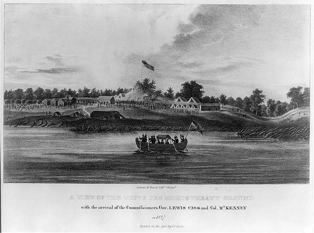
“A view of the Butte des Morts treaty ground with the arrival of the commissioners Gov. Lewis Cass and Col. McKenney in 1827” by James Otto Lewis, 1835.
~ Library of Congress
Their march was up the valley of the river, recrossing above Des Peres, passing the great Kakolin, and the Big Butte des Morts to the present site of Oshkosh. Thence crossing again they followed the trail to the Winnebago villages, past the Apukwa or Rice lakes to Fort Winnebago, making about twenty miles a day. On the route they were inclined to straggle, presenting nothing of military aspect except a uniform of dirty blankets. Colonel Hamilton was not able to make them stand guard, or to send out regular pickets. They were expert scouts in the day time, but at night lay down to sleep in security, trusting to their dogs, their keen sense of hearing and the great spirit. On the approach of day they were on the alert. It is a rule in Indian tactics to operate by surprises, and to attack at the first show of light in the morning.
From Fort Winnebago they moved to the Four Lakes, where Madison now is. Black Hawk had retired across the Wisconsin River, where there was a skirmish on the 21st of July, and the battle of the Bad Ax was being fought.

Photograph of Pierre Jean Édouard Desor (Swiss geologist and professor at Neuchâtel academy) from Wisconsin Historical Society. Desor and others were employed to survey for Report on the geology and topography of a portion of the Lake Superior Land District in the state of Michigan: Part I, Copper Lands; Part II, The Iron Region.
A few miles southwesterly of Waukedah, on the branch railroad to the iron mines of the upper Menominee, is a lake called by the Indians “Shope,” or Shoulder Lake, which I visited in the fall of 1850, in company with the late Edward Desor, a scientist of reputation in Switzerland. It discharges into the Sturgeon River, one of the eastern branches of the Menominee. There was a collection of half a dozen lodges, or wigwams, covered with bark, with a small field of corn, and the usual filth of an Indian village. The patriarch, or “chief” of that clan, came out to meet us, attended by about thirty men, women and children. By the traders he was called “Governor.” His nose was prominently Roman. He stood evenly on both feet, with his limbs bare below the knees. The right arm was also bare, and over the left shoulder was thrown a dirty blanket, covering the chest and the hips. A mass of coarse black hair covered the head, but was pushed away from the face. The usual dark, steady, snakelike, black eye of the race examined us with a piercing gaze. His face, with its large, well proportioned features, was almost grand. his pose was easy, unstudied and dignified, like one’s ideal of the Roman patrician of the time of Cicero, such as sculptors would select as a model.
This band were the Chippewas, but the coast of Green Bay was occupied by Menominees or Menomins, known to the French as “Folle Avoines,” or “Wild Rice” Indians, for which Menomin is the native name. Above the Twin Falls of the Menominee was an ancient village of Chippewas, called the “Bad Water” band, which is their name for a series of charming lakes not far distant, on the west of the river. They said their squaws, a long time since, were on the lakes in a bark canoe. Those on the land saw the canoe stand up on end, and disappear beneath the surface with all who were in it. “Very bad water.” From that time they were called the “Bad Water” lakes.

The Bad Water Band of Lake Superior Chippewa was first documented by Captain Thomas Jefferson Cram in his 1840 report to Congress.
~ Dickinson County Library
Cavalier was a half-breed French and Menominee. He was a handsome young man, and was well aware of it. Though he was married, the squaws received his attentions without much reserve. Half-breeds dress like the whites of the trading post, and not as Indians. Their hair is cut, and instead of a blanket they have coarse overcoats, and wear hats. Many of them are traders, a class mid-way between the whites and Indians.

No Princess Zone: Hanging Cloud, the Ogichidaakwe is a popular feature here on Chequamegon History.
Polygamy is the most fixed of savage institutions, and one that the half-breed and trader does not despise. Chippewa maidens, and even wives, have many reasons for looking kindly upon men who wear citizens’ clothes and trade in finery. Moccasins they can make very beautifully, but shawls and strouds of broadcloth, silk ribbons, pewter broaches, brass rings, and glass beads they cannot. These are the work of the white man. But none of that race, man or maid, has a more powerful passion for the ornamental than the children of the forest, male or female. Let us not judge the latter too harshly – poor, ignorant, suffering slave, with none of the protection which the African slave could sometimes invoke against barbarian cruelty. Their children are as happy and playful as those of the white race. Before they become men and women they are frequently beautiful, the deep brunette of their complexion having, on the cheek, a faint tinge of a lighter color, especially among those from the far north, like the “Bois Forts” of Rainy Lake. Young lads and girls have well formed limbs and straight figures, with agile and graceful movements. At this age the burdens and hardships of the squaws have not deformed them. The smoke of the lodge has not tanned their skin to Arab-like blackness nor inflamed their eyes. In about ten years of drudgery, rowing the canoe, putting up lodges, bearing children, and not infrequent beatings by her lord, the squaw is an old woman. Her features become rough and angular, the melodious voice of childhood is changed to one that is sharp, shrill, piercing and disagreeable. At forty she is a decrepit old woman, and before that time, if her master has not put her away, he may have installed number two as an additional tyrant.
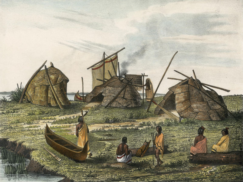
A Menominee village in “Village of Folle-Avoines” by Francis de Laporte de Castelnau, 1842.
~ Wisconsin Historical Society
Well up the Peshtigo, on a rainy, foggy afternoon, we made an early camp near a dismal swamp on the low ground. On the other side of the river, at a considerable distance, was heard the moans of a person evidently in great distress. Cavalier was sent over to investigate. He found a wigwam with a Menominee and two women, both wives. The youngest was on a bridal tour. The old wife had broken her thigh about a month before, which had not been set. She was suffering intensely, the limb very much swollen, and the bridal party wholly neglecting her. It was evident that death was her only relief. A strong dose of morphine gradually moderated her groans, which were more pathetic than anything that ever reached my ears. Before morning she was quiet.
As the water was very low I went through the gorge of the Menominee above the Great Bekuennesec, or Smoky Falls. Near the lower end, and in hearing of the cataract, I saw through the rocky chasm a mountain in the distance to the northeast. My half-breed said the Indians called it Thunder Mountain. They say that thunder is caused by an immense bird which goes there, when it is enveloped by clouds and flaps its wings furiously.
Turning away from the mists of the cataract and its never ceasing roar, we went southwesterly among the pines, over rocks and through swamps, to a time worm trail leading from the Bad Water village to the Pemenee Falls. This had been for many years the land route from Kewenaw Bay to the waters of Green Bay at the mouth of the Menominee River. When the copper mines on Point Kewenaw were opened, in 1844 and 1845, the winter mail was carried over this route on dog trains, or on the backs of men. Deer were very plenty in the Menominee valley. Bands of Pottawatomies scoured the woods, killing them by hundreds for their skins. We did not kill them until near the close of the day, when about to encamp. Cavalier went forward along the trail to make camp and shoot a deer. I heard the report of his gun, and expected the usual feast of fresh venison. “Where is your deer?” “Don’t know; some one has put a spell on my gun, and I believe I know who did it.”
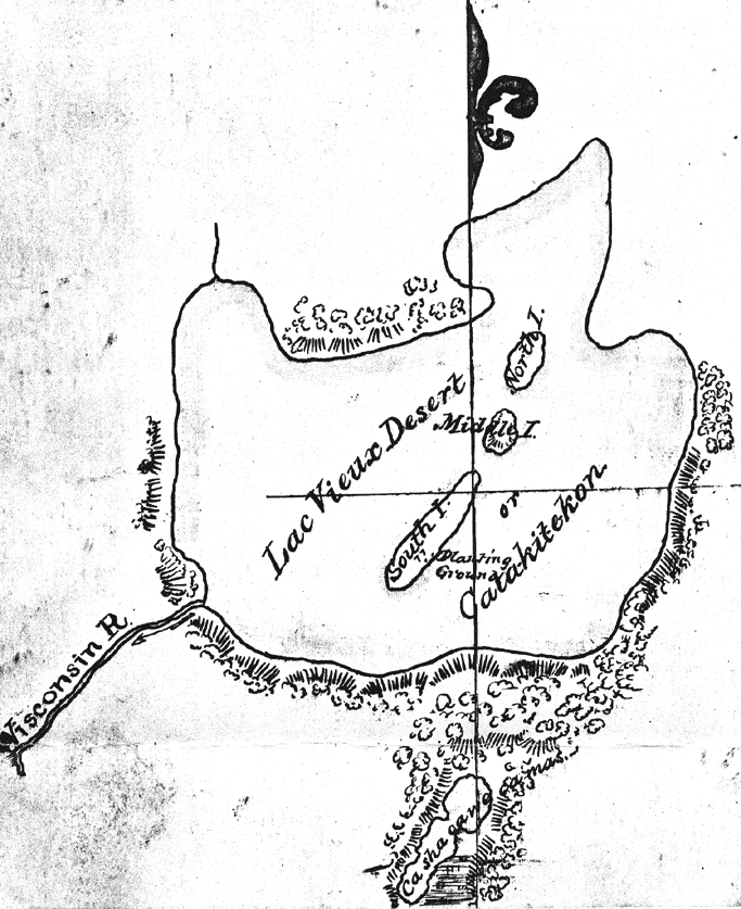
Map of Lac Vieux Desert with “Catakitekon” [Gete-gitigaan (old gardens)] from Thomas Jefferson Cram’s 1840 fieldbook.
~ School District of Marshfield: Digital Time Travelers
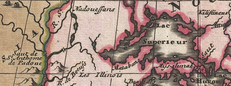
The Chippewas are spread over the shores and the rivers of Lake Superior, Lake Nipigon, the heads of the Mississippi, the waters of Red Lake, Rainy Lake and the tributaries of the Lake of the Woods. When Du Lhut and Hennepin first became acquainted with the tribes in that region, the Sioux, Dacotas, or Nadowessioux, and the Chippewas were at war, as they have been ever since. The Sioux of the woods were located on the Rum, or Spirit River, and their warriors had defeated the Chippewas at the west end of Lake Superior. Hennepin was a prisoner with a band of Sioux on Mille Lac, in 1680, at the head of Rum River, called Isatis. When Johnathan Carver was on the upper Mississippi, in 1769, the Chippewas had nearly cleared the country between there and Lake Superior of their enemies. In 1848 their war parties were still making raids on the Sioux and the Sioux upon them.
CHARLES WHITTLESEY.
To be continued in Among The Otchipwees: II…
By Amorin Mello
A curious series of correspondences from “Morgan”
… continued from Copper Harbor Redux.

The Daily Union (Washington D.C.)
“Liberty, The Union, And The Constitution.”
August 29, 1845.
EDITOR’S CORRESPONDENCE.
—
[From our regular correspondent.]
ST. LOUIS, Mo. Aug. 19, 1845.
One of the most interesting sections of the North American continent is the basin of the Upper Mississippi, being, as it is, greatly diversified by soil, climate, natural productions, &c. It embraces mineral lands of great extent and value, with immense tracts of good timber, and large and fertile bodies of farming land. This basin is separated by elevated land o the northeast, which divides the headwaters of rivers emptying into the Mississippi from those that flow into the lakes Superior and Michigan, Green Bay, &c. To the north and northwest, it is separated near the head of the Mississippi, by high ground, from the watercourses which flow towards Hudson’s bay. To the west, this extensive basin is divided from the waters of the Missouri by immense tracts of elevated plateau, or prairie land, called by the early French voyageurs “Coteau des Prairies,” signifying “prairie coast,” from the resemblance the high prairies, seen at a great distance, bear to the coast of some vast sea or lake. To the south, the basin of the Upper Mississippi terminates at the junction of the Mississippi with the Des Moines river.
The portion of the valley of the Mississippi thus described, if reduced to a square form, would measure about 1,000 miles each way, with St. Anthony’s falls near the centre.
1698 detail of Saint Anthony’s Falls and Lake Superior from Amerique Septentrionalis Carte d’un tres grand Pays entre le Nouveau Mexique et la Mer Glaciace Dediee a Guilliaume IIIe. Roy de La Grand Bretagne Par le R. P. Louis de Hennepin Mission: Recol: et Not: Apost: Chez c. Specht a Utreght 1698.
~ Commons.Wikimedia.org
For a long time, this portion of the country remained unexplored, except by scattered parties of Canadian fur-traders, &c. Its physical and topographical geography, with some notions of its geology, have, as it were, but recently attracted attention.

Douglas Volk painting of Father Hennepin at Saint Anthony Falls.
~ Commons.Wikimedia.org

Father Antoine “Louis” Hennepin
~ Wikipedia.org
Father Hennepin was no doubt the first white man who visited St. Anthony’s falls. In reaching them, however, he passed the mouth of St. Peter’s river, a short distance below, without noticing it, or being aware of its existence. This was caused by the situation of an island found in the Mississippi, directly in front of the mouth of St. Peter’s, which, in a measure, conceals it from view.
After passing the falls, Father Hennepin continued to ascend the Mississippi to the St. Francis river, but went no higher.

Portrait of Jonathan Carver from his book, Travels through the interior parts of North America in the years 1766, 1767 and 1768.
~ Wisconsin Historical Society
In the year 1766, three years after the fall of Canada, Captain Johnathan Carver, who had taken an active part as an officer in the English service, and was at the surrender of Fort William Henry, where (he says) 1,500 English troops were massacred by the Indians, (he himself narrowly escaping with his life,) prepared for a tour among the Indian tribes inhabiting the shores of the upper lakes and the upper valley of the Mississippi. He left Boston in June of the year stated, and, proceeding by way of Albany and Niagara, reached Mackinac, where he fitted out for the prosecution of his journey to the banks of the Mississippi.
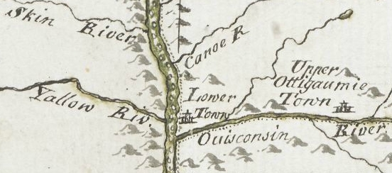
From Mackinac, he went to Green Bay; ascended the Fox river to the country of the Winnebago Indians; from thence, crossing some portages, and passing through Lake Winnebago, he descended the Wisconsin river to the Mississippi river; crossing which, he came to a halt at Prairie du Chien, in the country of the Sioux Indians. At the early day, this was an important trading-post between French traders and the Indians. Carver says: “It contains about three hundred families; the houses are well built, after the Indian manner, and well situated, on a very rich soil, from which they raise every necessary of life in great abundance. This town is the great mart whence all the adjacent tribes – even those who inhabit the most remote branches of the Mississippi – annually assemble about the latter end of May, bringing with them their furs to dispose of to the traders.” Carver also noticed that the people living there had some good horses.
Detail of Prairie du Chien from Carver [Jonathan], Captain. Journal of his travels with maps and drawings, 1766.
~ Boston Public Library
The fur-trade, which at one time centred here, and gave it much consequence, has been removed to St. Peter’s river. Indeed, this trade, which formerly gave employment to so many agents, traders, trappers, &c., conferring wealth upon those prosecuting it, is rapidly declining on this continent; in producing which, several causes conspire. The first is, the animals caught for their furs have greatly diminished; and the second is, that competition in the trade has become more extensive and formidable, increasing as the white settlements continue to be pushed out to the West.
John Jacob Astor established the American Fur Company.
~ Wikipedia.com
At Prairie du Chien is still seen the large stone warehouse erected by John Jacob Astor, at a time when he ruled the trade, and realized immense profits by the business. The United States have a snug garrison at this place, which imparts more or less animation to the scene. It stands on an extensive and rather low plain, with high hills in the rear, running parallel with the Mississippi.
The house in which Carver lodged, when he visited this place, is still pointed out. There are some men living at this post, whose grandfather acted as interpreter to Carver. The Sioux Indians, whom Carver calls in his journal “the Nadowessies,” which is the Chippewa appellation for this tribe of Indians, keep up the tradition of Carver’s visit among them. The inhabitants, descendants of the first settlers at Prairie du Chien, now living at this place, firmly believe in the truth of the gift of land made to Carver by the Sioux Indians.
From this point Carver visited St. Anthony’s falls, which he describes with great accuracy and fidelity, accompanying his description with a sketch of them.
![Detail of Saint Anthony's Falls from Carver [Jonathan], Captain. Journal of his travels with maps and drawings, 1766. ~ Boston Public Library](https://chequamegonhistory.com/wp-content/uploads/2016/05/carver-detail-of-st-anthony-falls.jpg)
Detail of Saint Anthony’s Falls from Carver [Jonathan], Captain. Journal of his travels with maps and drawings, 1766.
~ Boston Public Library
From the Mississippi river Carver crossed over to the Chippewa river; up which he ascended to its source, and then crossed a portage to the head of the Bois Brulé, which he called “Goddard’s river.” Descending this latter stream to Lake Superior, he travelled around the entire northern shore of that lake from west to east, and accurately described the general appearance of the country, including notices of the existence of the copper rock on the Ontonagon, with copper-mineral ores at points along the northeastern shore of the lake, &c.
![Detail of "Goddard's River," La Pointe, and Ontonagon from Carver [Jonathan], Captain. Journal of his travels with maps and drawings, 1766. ~ Boston Public Library](https://chequamegonhistory.com/wp-content/uploads/2016/05/carver-detail-of-goddard-river-and-la-pointe.jpg)
Detail of “Goddard River,” La Pointe, and Ontonagon from Carver [Jonathan], Captain. Journal of his travels with maps and drawings, 1766.
~ Boston Public Library
He finally reached the Sault St. Marie, where he found a French Indian trader, (Monsieur Cadot,) who had built a stockade fort to protect him in his trade with the Indians.
![Detail of Sault Ste Marie from Carver [Jonathan], Captain. Journal of his travels with maps and drawings, 1766. ~ Boston Public Library](https://chequamegonhistory.com/wp-content/uploads/2016/05/carver-detail-of-sault-ste-marie.jpg)
Detail of Sault Ste Marie from Carver [Jonathan], Captain. Journal of his travels with maps and drawings, 1766.
~ Boston Public Library
Descendants of this Monsieur Cadot are still living at the Sault and at La Pointe. We met one of them returning to the latter place, in the St. Croix river, as we were descending it. They, no doubt, inherit strong claims to land at the falls of the St. Mary’s river, which must ere long prove valuable to them, if properly prosecuted.
From the Sault St. Marie, Carver went to Mackinac, then garrisoned by the English, where he spent the winter. The following year he reached Boston, having been absent about two years.
From Boston he sailed for England, with a view of publishing his travels, and securing his titles to the present of land the Sioux Indians have made him, and which it is alleged the English government pledged itself to confirm, through the command of the King, in whose presence the conveyance made to Carver by the Sioux Indians was read. He not only signified his approval of the grant, but promised to fit out an expedition with vessels to sail to New Orleans, with the necessary men, &c., which Captain Carver was to head, and proceed from thence to the site of this grant, to take possession of it, by settling his people on it. The breaking out of the American revolution suspended this contemplated expedition.
Captain Carver died poor, in London, in the year 1780, leaving two sons and five daughters. I consider his description of the Indians among whom he travelled, detailing their customs, manners, and religion, the best that has ever been published.
In this opinion I am sustained by others, and especially by old Mr. Duncan Graham, whom I met on the Upper Mississippi. He has lived among the Indians ever since the year 1783. He is now between 70 and 80 years old. He told me Carver’s book contained the best account of the customs and manners of the Indians he had ever read.
His valuable work is nearly out of print, it being rather difficult to obtain a copy. It went through three editions in London. Carver dedicated it to Sir Joseph Banks, president of the Royal Society. Almost every winter on the Indians and Indian character, since Carver’s time, has made extensive plagiarisms from his book, without the least sort of acknowledgement. I could name a number of authors who have availed themselves of Carver’s writings, without acknowledgement; but as they are still living, I do not wish to wound the feelings of themselves or friends.
One of the writers alluded to, gravely puts forth, as a speculation of his own, the suggestion that the Winnebagoes, and some other tribes of Indians now residing at the north, had, in former times, resided far to the south, and fled north from the wars and persecutions of the bloodthirsty Spaniards; that the opinion was strengthened from the fact, that the Winnebagoes retained traditions of their northern flight, and of the subsequent excursions of their war parties across the plains towards New Mexico, where, meeting with Spaniards, they had in one instance surprised and defeated a large force of them, who were travelling on horseback.
Now this whole idea originated with Carver; yet Mr. ——— has, without hesitation, adopted it as a thought or discovery as his own!

Alexander Henry, The Elder.
~ Wikipedia.com
The next Englishman who visited the northwest, and explored the shores of Lake Superior, was Mr. Henry, who departed from Montreal, and reached Mackinac through Lake Huron, in a batteau laden with some goods. His travels commenced, I believe, about 1773-‘4, and ended about 1776-‘7. Mr. Henry’s explorations were conducted almost entirely with the view of opening a profitable trade with the Indians. He happened in the country while the Indians retained a strong predilection in favor of the French, and strong prejudices against the English. It being about the period of the Pontiac war, he had some hazardous adventures among the Indians, and came near losing his life. He continued, however, to prosecute his trade with the Indians, to the north and west of Lake Superior. Making voyages along the shores of this lake, he became favorably impressed with the mineral appearances of the country. Finding frequently, through is voyageurs, or by personal inspections, rich specimens of copper ore, or of the metal in its native state, he ultimately succeeded in obtaining a charter from the English government, in conjunction with some men of wealth and respectability in London, for working the mines on Lake Superior. The company, after making an ineffectual attempt to reach a copper vein, through clay, near the Ontonagon, the work was abandoned, and was not afterwards revived.
General Cass, with Colonel Allen, &c., were the next persons to pass up the southern coast of Lake Superior, and, in going to the west and northwest of the lake, they travelled through Indian tribes in search of the head of the Mississippi river. Their travels and discoveries are well known to the public, and proved highly interesting.
Mr. Schoolcraft’s travels, pretty much over the same ground, have also been given to the public; as also the expedition of General Pike on the Upper Mississippi.

Major Stephen Harriman Long published his expedition as Voyage in a Six-oared Skiff to the Falls of St. Anthony in 1817.
~ Wikipedia.org
More lately, the basin of the Upper Mississippi has received a further and more minute examination under the explorations directed by Major Long, in his two expeditions authorized by government.

Joseph Nicholas Nicollet
~ Wikipedia.org
Lastly, Mr. J. N. Nicollet, a French savan, travelling for some years through the United States with scientific objects in view, made an extensive examination of the basin of the Upper Mississippi.
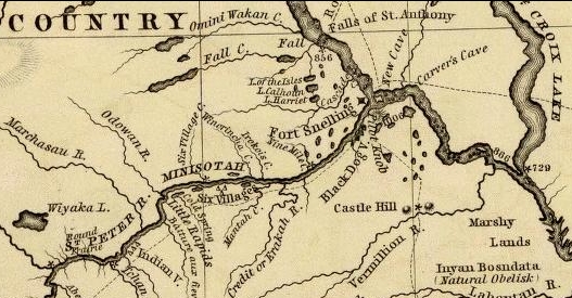
He ascended the Missouri river to the Council Bluffs; where, arranging his necessary outfit of men, horses, provisions, &c., (being supplied with good instruments for making necessary observations,) he stretched across a vast tract of country to the extreme head-waters of the St. Peter’s, determining, as he went, the heights of places above the ocean, the latitude and longitude of certain points, with magnetic variations. He reached the highland dividing the waters of the St. Peter’s from those of the Red river of the North. He descended the St. Peter’s to its mouth; examined the position and geology of St. Anthony’s falls, and then ascended the same river as high as the Crow-wing river. The secondary rock observed below the falls, changes for greenstone, sienite, &c., with erratic boulders. On the east side of the river, a little below Pikwabik, is a large mass of sienitic rock with flesh-colored feldspar, extending a mile in length, half a mile in width, and 80 feet high. This is called the Little Rock. Higher up, on the same side, at the foot on the Knife rapids, there are sources that transport a very fine, brilliant, and bluish sand, accompanied by a soft and unctuous matter. This appears to be the result of the decomposition of a steachist, probably interposed between the sienitic rocks mentioned. The same thing is observed at the mouths of the Wabezi and Omoshkos rivers.
Detail of Saint Anthony’s Falls and Saint Peter’s River from Hydrographical Basin of the Upper Mississippi River from Astronomical and Barometrical Observations Surveys and Information by Joseph Nicolas Nicollet, 1843.
~ David Rumsey Map Collection
Ascending the Crow-wing river a short distance, Mr. Nicollet turned up Gull river, and proceeded as far as Pine river, taking White Fish lake in his way; and again ascended the east fork of Pine river, and reached Little Bay river, which he descended over rapids, &c., to Leech lake, where he spent some days in making astronomical observations, &c. From Leech lake, he proceeded, through small streams and lakes, to that in which the Mississippi heads, called Itasca. Having made all necessary observations at this point, he set out on his return down the Mississippi; and finally, reaching Fort Snelling at St. Peter’s, he spent the winter there.

Detail of Leech Lake and Lake Itasca from Hydrographical Basin of the Upper Mississippi River from Astronomical and Barometrical Observations Surveys and Information by Joseph Nicolas Nicollet, 1843.
~ David Rumsey Map Collection
Lake Itasca, in which the Mississippi heads, Mr. Nicollet found to be about 1,500 feet above the level of the ocean, and lying in lat. about 47° 10′ north, and in lon. 95° west of Greenwich.
This vast basin of the Upper Mississippi forms a most interesting and valuable portion of the North American continent. From the number of its running streams and fresh-water lakes, and its high latitude, it cannot fail to prove a healthy residence for its future population.
It also contains the most extensive body of pine timber to be found in the entire valley of the Mississippi, and from which the country extending from near St. Anthony’s falls to St. Louis, for a considerable distance on each side of the river, and up many of its tributaries, must draw supplies of lumber for building purposes.
In addition to these advantages, the upper basin is rich in mines of lead and copper; and it is not improbable that silver may also be found. Its agricultural resources are also very great. Much of the land is most beautifully situated, and fertile in a high degree. The climate is milder than that found on the same parallel of latitude east of the Alleghany mountains. Mr. Nicollet fixes the mean temperature at Itasca lake at 43° to 44°; and at St. Peter’s near St. Anthony’s falls, at 45° to 46°

“Maiden Rock. Mississippi River.“ by Currier & Ives. Maiden’s Rock Bluff. This location is now designated as Maiden Rock Bluff State Natural Area.
~ SpringfieldMuseums.org
Every part of this great basin that is arable will produce good wheat, potatoes, rye, oats, Indian corn to some extent, fine grasses, fruits, garden vegetables, &c. There is no part of the Mississippi river flanked by such bold and picturesque ranges of hills, with flattened, broad summits, as are seen extending from St. Anthony’s falls down to Prairie du Chien, including those highlands bordering Lake Pepin, &c. Among the cliffs of sandstone jutting out into perpendicular bluffs near the river, (being frequently over 100 feet high,) is seen one called Maiden’s rock. it is said an Indian chief wished to force his daughter to marry another chief, while her affections were placed on another Indian; and that, rather than yield to her father’s wishes, she cast herself over this tall precipice, and met an instant death. On hearing of which, her real lover, it is said, also committed suicide. Self-destruction is very rare among the Indians; and we imagine, when it does occur, it must be produced by the strongest kind of influence over their passions. Mental alienation, if not entirely unknown among them, must be exceedingly rare. I have no recollection of ever having heard of a solitary case.
From St. Anthony’s falls to St. Louis is 900 miles. The only impediment to the regular navigation of the river by steamboats, is experienced during low water at the upper and lower rapids.
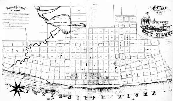
“St. Louis Map circa 1845”
~ CampbellHouseMuseum.org
The first are about 14 miles long, with a descent of only about 25 feet. The lower rapids are 11 miles long, with a descent of 24 feet. In each case, the water falls over beds of mountain or carboniferrous limestone, which it has worn into irregular and crooked channels. By a moderate expenditure of money on the part of the general government, which ought to be made as early as practicable, these rapids could be permanently opened to the passage of boats. As it is at present, boats, in passing the rapids at low water, and especially the lower rapids, have to employ barges and keel-boats to lighten them over, at very great expense.
From the rapid settlement of the country above, with the increasing trade in lumber and lead, the business on the Upper Mississippi is augmenting at a prodigious rate. When the river is sufficiently high to afford no obstruction on the lower rapids, not less than some 28 or 30 boats run regularly between Galena and St. Louis – the distance being 500 miles. Besides these, two or three steam packets run regularly to St. Anthony’s falls, or to St. Peter’s, near the foot of them. Every year will add greatly to the number of these boats. Other fine large and well-found packets run from St. Louis to Keokuk, at the foot of the lower rapids, four miles below which the Des Moines river enters the Mississippi river. It is the opinion of Mr. Nicollet, that this river can be opened, by some slight improvements, for 100 miles above its mouth. It is said the extensive body of land lying between the Des Moines and the Mississippi, and running for a long distance parallel with the left bank of the latter, contains the most lovely,rich and beautiful land to be found on the continent, if not in the world. It is already pretty thickly settled. Splendid crops of wheat and corn have been raised on farms opened upon it, the present year. Much of the former we found had already arrived at depots on the river, in quantities far too great to find a sufficient number of boats, at the present low water, to carry it to market.
I do not see but the democratic party are regularly gaining strength throughout the great West, as the results of the recent elections, which have already reached you, sufficiently indicate.
Those who wish to obtain more general, as well as minute information, respecting the basin of the Upper Mississippi, I would recommend to consult the able report, accompanied with a fine map of the country, by Mr. J. N. Nicollet, and reprinted by order of the Congress at their last session.
I am, very respectfully,
Your obedient servant,
MORGAN.
This curious series of correspondences from “Morgan” is continued in the September 1 and September 5 issues of The Daily Union, where he arrived in New York City again after 4,200 miles and two and a half months on this delegation. As those articles are not pertinent to the greater realm of Chequamegon History, this concludes our reproduction of these curious correspondences.
