Edwin Ellis Incidents: Number IV
August 31, 2018
By Amorin Mello

Originally published in the July 14th, 1877, issue of The Ashland Press. Transcribed with permission from Ashland Narratives by K. Wallin and published in 2013 by Straddle Creek Co.
… continued from Number III.
EARLY RECOLLECTIONS OF ASHLAND.
“OF WHICH I WAS A PART.”
Number IV
My Dear Press: – In March 1855, Conrad and Adam Goeltz – then young men, came to Ashland. They were natives of Wittenberg, and Conrad had served six years in the Cavalry of that Kingdom; but liking freedom, he bade adieu to the King, his master, and came to the “Land of the Free.” They both cleared land near the town site, which they afterwards pre-empted, and bought from the U.S. Government. For several years both of them lived in Michigan, but upon the revival of Ashland they came back to their early home. Katy Goeltz, Conrad’s Daughter, was the first white child born in this town, in the fall of 1855. Henry Dretler, Mrs. Conrad Goeltz’s father, came early and bought a quarter section of land. He died here in 1858 and was buried near the present residence of Mr. Durfee.
In June 1855, Dr. Myron Tompkins (brother-in-law of Mr. Whittlsey) came to the bay in search of health. He had been driven from Illinois by ague and rheumatism. The climate cured the ague, and accidentally falling off from a raft in the bay – the severe shock cured the rheumatism. Being thus cured by our climate and water, he has ever since lived on the lake. He is a well-educated physician. At present he is the physician of the Silver Islet Mining Company, on the North Shore of the Lake.
I recall others who came in 1855; Andrew Scobie, now of Ontonagon, Thomas Danielson, Charles Day, (now farming on Fish Creek,) Joseph Webb, Bernard Hoppenjohn, Duncan Sinclair, Lawrence Farley, and Austin Corser. Farley died many years ago, but his widow, after years of absence, has again returned to Ashland. Austin Corser in the summer of 1855 began a farm on the east side of Fish Creek, about half a mile above the mouth. Remaining only two or three years, he went to Ontonagon and afterwards to Iron River – in a wild lonely glen – where in after years from 1873 to 1876. He sold his homestead on which the Scranton Mining Company was formed for a snug little fortune, on which he settled down on a farm near Waukegan, Illinois.
John Beck, also coming in the early days of Ashland. He pre-empted and lived upon the spot now laid out and occupied as our cemetery. His wife was the first adult person who died in this town. The remains of the house in which she died may be seen near the Ashland Lumber Company’s store. He was for many years an active explorer for minerals, was the originator of the Montreal River Copper Mining Company. Subsequently he discovered silver lodes on the North Shore, in Canada. He is now engaged in gold mining in California.
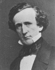
Albert C. Stuntz was also one of our early settlers. He is a brother of Geo. R. Stuntz, to whom reference has already been made. He was here engaged in practicing surveying and ran many hundred miles of township and section lines in this and neighboring counties. The townships embracing our Penoka Iron Range were subdivided by him in 1856 and ’57. He once represented this district in the Legislature. His old home is in ruins on the east bank of Bay City creek. Mrs. Stuntz, who endured much hardship and privation died here in 1862. Mr. S. at present lives at Monroe, in this State.
Geo. E. Stuntz. nephew of A.C. and great grandson of the old Hessian Soldier mentioned in a former chapter, also came to Ashland early. In connection with his uncle and on his own account he did a great deal in the subdivision of the lands on the South Shore of the Lake. Soon after the outbreak of our civil war he enlisted in defense of the Union – was severely wounded and died, as it is supposed, in consequence of his wounds.
~ Sarah Adah Ashe – Part IV – San Bernardino by Marta Tilley Belanger

Welton’s mill and Sibley’s farm were both located along the trail south from Ashland to the Penokee Mountains on the 1860 Geological Map of the Penokie Range by Charles Whittlesey.
~ Geology of Wisconsin. Survey of 1873-1879.
Volume III., 1880, Plate XX, page 214.
J. T. Welton and T.P. Sibley, though never living in Ashland, were yet closely identified with its early history. Mr. Welton came about 1850 to Bad River, where he was Government Farmer among the Indians. He was an ingenious mechanic, and could build a water mill. He was on the lookout for a mill site, and finally in 1854 discovered the falls on White River, six miles south of Ashland. It was an unfailing supply of water, with abundant head and fall, and the river was not subject to great rises. As a mill site it has few rivals. His resolution was quickly formed. The rising town on the bay would afford a ready market for all the lumber he could make. The mill should be built. He corresponded with his brother-in-law, Mr. Sibley, and he was eager to come and make his fortune in this new country; and in Nov. 1855, Mr. Sibley and his wife and one little daughter, about a year old, landed upon our shores. During the summer of 1855 Mr. Welton had built a log house at White River. It still stands, though in ruins. Thither late in Nov. 1855, the two families removed. The sisters were refined, cultivated and Christian ladies from the Western Reserve, in Ohio – a spot itself favored by counting among its early settlers some of the best families of New England, and which had been the new center in the west, whence have validated those influences which have tended to improve and elevate the moral and religious condition of the millions of this new empire. They were of Puritan stock. An unbroken wilderness was around them and their nearest neighbors were at Ashland, six miles away. No time was lost. The work of opening up a farm and building a mill was at once begun. They had little money and the labor must be done with their own hands. The casting for the mill must be brought a thousand miles – from Detroit. Nearly a year of toil had passed, when in October, 1856, a few days before the election of James Buchanan to the Presidency – all the able bodied men were invited to go the mill raising at White River. We went and the frame was up, but it was not until 1857 that they could set the mill running. They were greatly impeded for want of capital in cutting logs and floating down the logs to the mill and sawing a few thousand feet of lumber. But before anything could be realized from it they must either haul it over bad roads to Ashland (6 miles) or raft it down many miles to the Lake. But the river was full of jams and “flood wood” – enough to discourage puny men.
The panic of 1857 and resulting hard times put an end to all building at Ashland, and so their hopes of selling their lumber near home were blasted and after struggling vainly for some time longer, Mr. Welton was finally compelled to abandon his home, which he had labored so hard to establish. He found friends and employment in the copper mines of Michigan, and after somewhat improving his fortunes finally settled in south western Iowa, where he now resides.
In some subsequent chapter I will, with your leave, recur to Mrs. Sibley and the circumstances connected with her death.
To be continued in Number V…
Barber Papers: “In a Little Trouble” Winter of 1856
October 9, 2015
By Amorin Mello
Selected letters of the Joel Allen Barber Papers
… continued from Fall of 1855.
Minnesota Point Jan [23rd?] 1856
Dear Parents
It is sometime since I have wrote to you and for a fortnight or more
[???] [two lines on this copy are illegible] [??? ?????]
On arriving at Lapoint we found sheets from home and a good lot of newspapers.
We left Lapoint Thursday afternoon [on a firm of ?????? ? ?? head?] of [?????????] Nagonup the principal chief of all the Chippewas, Augustus and myself [??? ??? ?????] drawn by by two dogs on a dogtrain. At [????? ???????] were joined by one of Nagonup’s [??????].

Photograph of Naagaanab (Minnesota Historical Society).
They were on their way to Washington. Several of them are going accompanied by a gentleman from Lapointe as interpreter. The first night out we stayed in a wigwam with old Chingoon and his interesting family. Friday night we camped. Saturday reached Iron river. Sunday left and [comfortable?] – Monday came here. Augustus has a sore througt, not severe – otherwise we are well as usual notwithstanding our tramp of over [100?] miles. I must now quit writing and try to find one of our dogs which has strayed over to [???].
Under the old permit system, many locations, three miles square, were made on Lake Superior;- several on and near the Montreal river – some on Bad River, south of La Pointe – three on the main land, opposite La Pointe – two or three were made near Superior City, on the Nemadji, or Left Hand river, and one settler’s claim about twenty miles north of Superior.”
~ Mineral Regions of Lake Superior: As Known From Their First Discovery to 1865, by Henry Mower Rice, 1865[?].
Perhaps you wonder what we have made this journey for – perhaps you hope we are going below but that is not the case. Why should we [?????]. It is warmer here than at many places two or three hundred miles south of here. True – one or two thermometers froze up at this place but others did not while at Fort Snelling, the spirit thermometer inside the walls indicated 44 degrees below zero. Augustus wanted to see to his preemption and I had nothing to do but to come along with him. I also wanted to find out a few things concerning a place that I should like to preempt. I suppose there is not a better copper show on the south shore of the lake, but the land is not surveyed and my only sure way to get it is to settle on it and stick to it until it can be legally claimed.
The town lines will be run next summer.
Augustus is in a little trouble about his claim. It appears his declatory statement never reached the land office. But I guess it will all be explained and made right. The dutchman who was to contest his claim has left the country and would stand no chance if he was here. We have a land office here now which saves a great many journeys to Hudson near St. Paul. We shall go back in a few days and commence surveying around the islands. Now don’t fancy that we cannot survey in the winter, for we have tried it and know better.
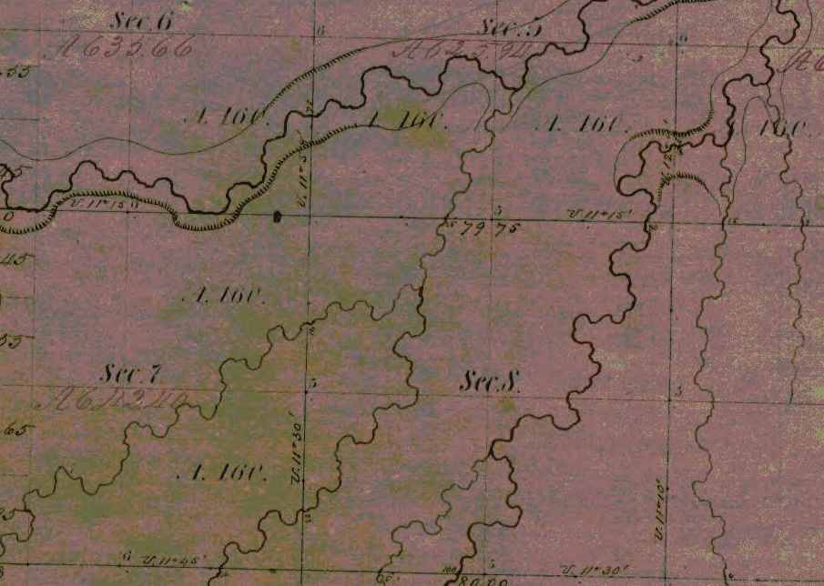
Detail from the Stuntz/Barber survey of T47N R14W.
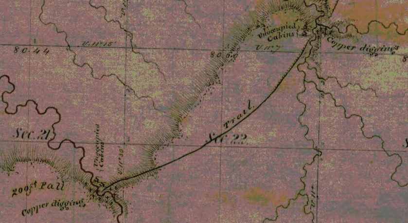
“J.H. Bardon, a Superior pioneer, stated that ‘at Copper Creek and Black River Falls, twelve or fifteen miles south of Superior, and also near the Brule River, a dozen miles back from Lake Superior, Mr. Stuntz found evidences of mining and exploring for copper on a considerable scale carried on by the American Fur Company, under the direction of Borup and Oaks of La Pointe, in 1845-46. A tote road for the mines was opened from a point ten miles up the Nemadji River to Black River Falls.‘”
~ Duluth and St. Louis County, Minnesota; Their Story and People: An Authentic Narrative of the Past, with Particular Attention to the Modern Era in the Commercial, Industrial, Educational, Civic and Social Development, Volume 1, by Walter Van Brunt, 1921, page 66.
At Bad river we were at work during the coldest weather, and only lost two or three days because of cold but when the thermometer was up to 20* below zero we worked right ahead – sometimes in swamps where we stepped through the snow into the water,
[last line on this page of this copy is cut off]
The weather for a week or more has been fine. Cold enough to cover us with frost but not severe.
Provisions are very scarce – no flour or pork can be had.
They will begin to bring them through from St. Paul in a few days. Flour it is hoped can then be bought for $20 per barrel. Fish are not exactly plenty but they can be obtained for money or labor which is not the case with anything else. The country is flooded with dry goods, [p??y] articles and everything but provisions because they can be bought on time but eatables could only be got by paying cash down.
Geology of Wisconsin: Survey of 1873-1879,
Volume III, 1880, page 342[?].

Geology of Wisconsin: Volume 3, page 341.
Geology of Wisconsin: Volume 3, page 345.
The Fon du Lac mine has commenced operations with tolerable fair prospects. It is the only mine in operation this side of Montreal river. Augustus’ claim is on the same vein and for aught anyone knows just as good besides having abundance of water power. All the copper excitement since I come to the country has been directed toward the north shore. This morning I signed 2 petitions, one to congress for the early survey of the north shore and another for a road down that way. I have made a little map of the islands and last summers survey and some other things that I will enclose.
The Fond du Lac copper prospect was located near a small tributary of the Left Hand River on this map detail from T47N R14W, near Pattison State Park. Augustus’ claim was along the same vein of copper but had not been surveyed yet; perhaps it was at Amnicon Falls State Park.
Augustus has begun a letter to send with this. He has just come home with letters now about his claim.
No more at present from
Your affectionate son
J. Allen Barber
Direct to Lapoint
Minnesota Point
Superior County
Minn. Terr.
Sunday Feb 10th 1856
Dear Mother
Augustus has written a letter, and left it for me to enclose and dispatch so I thought I would ship in a few lines before sending it off.
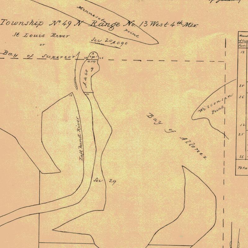
Augustus started today with a young man and two dogs for Lapointe. I shall probably go there in a two or three weeks to return immediately. There are two men going down with a tamlins pony team with provisions from St. Paul for Augustus. The men are going to work for him and I shall probably bring the team back and use it a while. I have at last fixed my mind on a place that I mean to claim. The location is a point at the mouth of Left hand river, known as Left hand point. It contains only 5 or 6 acres in low & swampy and covered only with bushes coarse grass and floodwood. Nothing but the fact of its being a part of Superior city is of any value whatever.

Barber’s sketch of his land claim at the mouth of Left Hand River. This location is now an industrial neighborhood of Superior on the Nemandji River.
As it is $1,000.00 per acre is not an overestimate of its marketable price at present. It joins or is part of the grounds intended for the Railroad buildings when the survey was made here this point was cut off by the meander lines instead of meandered. Therefore according to the [rearns/records?] no such land exists.
A resurvey is to be made and I mean to fasten it by a preemption which is the only way to obtain it before the land sale. I may get cheated out of it and I may throw away my time and money but such chances are scarce and should it transpire that my claim is good I want to have my dish right side up for once. I have written for Uncle Allen’s advice and should I ever find it advisable to drop the matter I can do so without forfeiting my preemption right.
The Eye of the North-west, page 9.
The Superior Company with Company with which I shall probably have to contend is rich, influential, and on good terms with the administration. All that can be done by fair means or foul to defeat any claim will probably be done, but some things can be done as well as others, at any rate we shall see what we shall see.
So my head is so full of business just [snow?] you will please excuse the shortness of this letter and look for more when I have more time.
Your affectionate son
J Allen Barber
Superior Feb. 17th 1856
Dear Brother
It is sometime since I have written anything to you but you have heard of me so often that I suppose it makes no particular difference. It will be nearly sugaring time when you get this.

Makak: a semi-rigid or rigid container: a basket (especially one of birch bark), a box (Ojibwe People’s Dictionary) Photo: Densmore Collection; Smithsonian
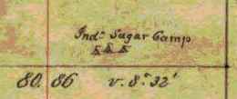
I have once more got into a country where sugar is made but not by white men. The Indians make pretty good sugar which is generally done hard and [sinted?] dry and put into birch bark “mo’kucks” holding from 50 to 75 lbs. This bark is also used exclusively for buckets, store trays, gathering pails, &c. The timber in this country is not as equally distributed as in Vermont. The land is mostly covered with evergreens but there are some located portions of country where maple abounds. These “sugar bushes” as they are called are often quite extensive covering several sections and and [they?] only at intervals of 8 or 10 miles, but this is just as well for the Indians are both migratory and gregarious in their habits.
Detail of an Lake Superior Chippewa “sugar bush” from the Barber brothers’ survey of T48N R5W.
I hope you will eat plenty of sugar next spring and take some of the girls to a sugar party or two like I used to. I am doing nothing now most of the time but shall have business enough in a few days when I begin to build my house that is if I conclude to grab for the price of land I am now watching. I am waiting to hear from Uncle Allen and for some other things to transpire. There is not a man in the country whom I could trust that could give me any reliable information such as I want. I want you to hurry and become of age as soon as possible and come out here this spring and make a preemption.
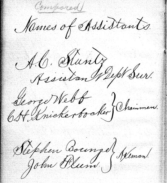
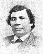
There are some good places left yet, but don’t get married before you make a preemption for it might not be convenient to take your wife out into the woods 30 or 40 miles to live on the place as you would have to do in order to “prove up.” I am going to get up an ice boat before long which will be very useful as I mean to do considerable boating yet this winter, and I might use it to carry lumber and other things up and down the lake. With such winds as we have had a few days ago I could easily go to Lapointe and back in two days. I suppose Augustus got a party started by this time and he will be at it himself in a few days. I am living with a man named Fargo, you have heard of him before. We are living in Stuntz’ store. Board at the hotel is ten dollars per week. Old Steven Bonga is living on the point, he has been something of a traveller having been to Montreal, Hudson Bay, [Oregon?], Prairie du Chien, and all intermediate places.
He is half indian and half negro so you may suppose he is not very white.

Portrait of Stephen Bonga (USDA Forest Service). Additional information about Bonga is available from the Wisconsin Historical Society.
A railroad has been laid out from here to St. Paul and my claim covers the terminus at this end. There have two or three new towns started into existence along its route in imagination. Perhaps they are [surveyed?]. This making towns in a new country is a great business.
What happened in your good town on Christmas and New years eve
Were there any stockings left.
I want to inquire about lots of girls and boys in Johnson and Cambridge but I conclude you will tell me as much as you can in your next letter so with respects to all enquiring friends I remain
Your affectionate brother
Allen
Superior, Douglas Co. Feb. 25th 56
Dear Parents

Detail of Superior City from T49N R1W.
Night before last I got a letter and some papers from Augustus also 2 letters from home which he had read. They were dated Dec. [21st?] & Jan 2nd.
Sad and startling was the news of the death of George Hill. Who could have thought three years ago that such a dark future lay before that family. Every day some sad event warns me of the uncertainty of life. Men have died here who had no friends to mourn their loss, and their death is hardly noticed. I always ask myself why was it not me instead of them and will not my turn come soon. Yes, let it come soon or late as the world reckon, and it will be soon to me.
There is just as much danger or accidents in this country as in any other and no more but as to health there is no better place in the world than this. You seem shocked at the idea of surveying in the winter, but it will be nothing but fun to survey during the rest of the winter. It has been moderate pleasant weather now about two weeks. The snow is going off a little lately and it seems a little like spring. We had some pretty cold weather about new years but we shall have no more such. The lake is more open than it ever was known to be at this season before.
It sometimes freezes across at Lapointe but now it is open within six or eight miles of here. Flour is only $20 per bbl‑ with prospect of falling lower. The Indians chiefs have returned having only been to St. Paul where they found a letter telling them to delay their visit a while.
Poor creatures! They are fooled around by traders and speculators who are with the government in robbing and dwindling them. Any thing like a full account of their wrongs would astonish even them. About my claim I have not [???] today. There is another man after it and it will be no easy thing to carry my point.
Valuable property is troublesome stuff in this country. There is a townsight three miles from there now in litigation for which there is a standing offer of $200,000.
I am still living with Fargo on Minnesota point. I expect to go to Lapointe before long with Albert Stuntz who is going down with some supplies for Augustus which he brought from St. Paul.
It is too dark to write
Good bye
Allen
Superior, March 4th 56
Dear Parents
Not much has happened in this vicinity worth recording. The principle circumstances of note is the burning of a house and all the worldly possessions of a poor [Indian?].
Detail of Left Hand River from Stuntz’s survey; where Barber’s land claim was located.
I have heard nothing of Augustus since writing last but expect to when anybody comes up the lake. About my claim I can say but little my chance is but dull still I don’t mean to give up so large a prize without good reasons.
I have had it surveyed and the notes sent to the Surveyor General with a memorial stating the facts and asking him to [appraise?] the [notes?].
The price contains over 8 acres (8.695).
Perhaps it occurred to you that I am was 22 years old last Sunday. Well such is unquestionably the case although nothing was done to celebrate the day only I had my hair cut for the third time after leaving Vermont. I think I shall have to go to Lancaster this spring but unless I get ousted here it will be difficult to leave.
I wish I could multiply myself by about a dozen in order to hold several valuable claims which are not occupied by any one who can legally hold them. I can’t write here two children [pretting?] and several people [telling?] Albert Stuntz and family are here today. I am perched on a sawhorse writing on a work bench loaded with all manner of [marbles?].
Evening – quiet once more since dark I have written a letter to the Surveyor General to accompany a memorial that I have been circulating. O I wish there was a person in the country that I could depend on to assist me in regard to that claim. There are one or two that I counsel with who know no more than I do and then I do as I think best.
I expect [Lowener?] to find out I have no show, and that will be the last of it I shall [not feel?] that I had lost it for I never had it, but if I don’t get it some body else will get 15 or 20 thousand dollars worth of land that I want.
Provisions are still high and will be higher again before navigation opens which cannot be expected before the 1st of May. Flour is $20/barrel, fresh pork 18 ¾ cents per lb, beef 20 cts milk 20 to 25 cts per qt. &c, &c. Eatables must be higher because there will be little or no sleighing after this over the barrens between here and St. Paul. My mind has been on the [rock?] so much today that I am not in a mood to think much about home so please excuse the shortness and dryness of this letter.
I remain your affectionate son
J Allen Barber
Went to Iron River Thursday 13
Returned 15th
Superior , Douglas Co. March 11 1856
Dear Parents
Yesterday I read a package of letters from Augustus containing one from him & from home one from Albe and one from [Caldridge?]. As Augustus was in town (Lapointe) when he recd. your letters I suppose he has answered them so I cannot tell you much news about him. I am still staying with Fargo – not doing much but hoping to get pay for my time and expense by securing the prize I am after. There is some excitement in town about it, but mighty little is said to me. The Register at the land office gives me good encouragement and says a preemption will hold it. I have taken some steps toward building on it. Today I bought a sack of flour ½ barrel for 12 dollars, I shall get some fish from Lapoint where they are very plenty and cheap and then I shall be almost ready to try housekeeping alone.

I am sorry to hear of the disastrous results of the low price of hops. Although farmers must suffer in consequence yet I believe speculators will make fortunes out of it. If I was in the business of raising them I should stick to it. No articles is so liable to fluctuations in prices as hops but it is well known that the risk fails once in five years on an average so they must come up sometime.
I see you are inclined to believe our country and climate are more in hospitable & forbidding than yours. Such I believe is not the case. We have had some very cold weather but the changes are so moderate and so seldom that we pay but little attention to the weather – in fact we call most all of it very fine weather, as it is. The lake is a great equalizer of temperatures and our cool lake atmosphere in summer causes showers to fall from all the warm, sweaty winds that come here to wash their faces in this big blue pond. People in this country go much better prepared for cold than they ever do in Vermont. I have not worn a boot since leaving Lancaster. We wear shoes in the summer and moccasins in winter.
Boots won’t do for surveyors – they carry too much water unless we stop to empty them after crossing every stream or marsh.
While speaking of clothes perhaps I might as well go on with a few more items of the same sort.
Shoes for this country should have no lining or binding as they are quicker and ae not as stiffwhen dry. We never apply anything to soften them and nothing can preserve them from wearing out in about two months of hard service. They [sell?] about $1.50 per pair. We can get plenty of wool hats which are the only ones we wear.
All manners of shirts can be bought, even the very best quality of red flannel ones, which are universally warm, outside, i.e. by common folks.
The gentry of Superior dress most distressingly.
It is difficult to get good socks any where on the country. I have worn out 6 or 7 pair this summer and lost some more – they cost high bests we don’t wear. I have none. The only cost I have is of [Gihon?] cloth and made by Mrs. Sheldon. Cost are not much more except as an extra garment to wear occasionally.
Good durable pants I find it difficult to get. They are generally poor [ashnet?] and not half put together. Good your mittens would be very acceptable but for want thereof buckskin or blanket mittens are generally warm.
You speak about bringing Kate [in?] to Wisconsin. My advice is to it without fail if you intend coming out to live, nothing should prevent it if I were in your place. The horse that Uncle [Jay?] brought out with him is smarter and tougher than any one he can find to use with him. There is nothing that I regard as more necessary for a family than a first rate horse. I think [Kelty?] will be a very good serviceable animal for work besides being one that you might be proud to ride [after?] over the prairies. Probably Augustus has told you what he thinks about Amherst and other boys coming out here to survey. Butler was so badly disappointed in this country that I have had but little thoughts of [enough?] any one else to come here. Such a disappointment I think would be the fate of 4 out of every 5 that try the business.
A person to be a surveyor must be able to travel all day through the woods and sometimes carry a pack. I would not prevent any from coming here as there is generally business enough besides surveying. A surveyor can make no greater mistake than by hiring any but the best of men. Perhaps Augustus has not told you that he will be out of the business as soon as his present job is done and will devote his time to the improvement of his claim &c. I should like very much to [have?] Amherst here but I dislike to have my parents left entirely alone. As I have [???] two half [sheets?] – when I only [illegible] mind up for the [present?].
[Incomplete copy of letter]
To be continued in the Spring of 1856…
By Amorin Mello
In our Penoka Survey Incidents series earlier this year, we followed some of the adventures and schemes of Albert Conrad Stuntz circa 1857. The legacy of Albert’s influential survey still defines the geopolitical landscape of the Penokee Mountains to this day. However, Albert’s work during the late 1850s was relatively minor in comparison to that of his brother, George Riley Stuntz, during the early 1850s. The surveying work of George and his employees started in 1852 and enabled the infamous land speculators and townsite promotors of Superior City to manifest their schemes by early 1854 (months before the Treaty of La Point occurred later that year).
Among the men that worked with George was Augustus Hamilton Barber. Sometime around 1850, Augustus had followed his Grandparents, Aunts, Uncles, and Cousins from the Barber family of Lamoille County, Vermont, to Lancaster in Grant County, Wisconsin. After a short career as a school teacher in Grant County, Augustus came to Lake Superior in 1852 employed by George as a Chainman under his contract with the United States General Land Office to survey lands at the Head of Lake Superior.
Before taking a closer look at the Barber Papers, let’s examine the lives and affairs of other surveyors and speculators along the southwest shore of Lake Superior, starting with George Riley Stuntz and his production of these Exterior Field Notes (June of 1852):


Duluth and St. Louis County, Minnesota;
Their Story and People
By Walter Van Brunt, 1921, pages 64-65.

Portrait of George Nettleton’s cabin on Minnesota Point in 1852 on page 75.
First Settler.– The honor, for both Superior and Duluth, must presumably go to George R. Stuntz. He came in 1852, and settled in 1853. Several were earlier of course, but can hardly be considered to have been legitimate independent settlers. Carlton had been on the ground, at Fond du Lac, for some years, but he was Indian agent; Borup and Oaks had spent their time between La Pointe and Fond du Lac, but were then at St. Paul, and mainly interested in the development of that city, and in fur trading. Wm. R. Marshall stated that he “was on the lake as early as 1848,” but not to settle and he did not come again until 1857. Wm. R. Marshall and George R. Stuntz were fellow-surveyors, in federal pay, “back in the ’40s,” but Marshall did not seek to take the place of Stuntz as premier pioneer at the head of Lake Superior. As a matter of fact, although “on the lake as early as “1848,” Marshall did not then get nearer to Duluth than La Pointe, where he met “Borup and Oaks, the principal traders, Truman Warren, George Nettleton, Cruttenden, Wattrous, Rev. Sherman Hall, E. F. Ely and others.” It is quite possible that Stuntz was with Marshall in 1848, for that was the year in which Stuntz first entered Minnesota territory “having charge of a surveying party that was working near Lake Pepin and in what is now Washington County.”
The “Heart of the Continent.”– George R. Stuntz prepared the way for the first attempt at white settlement at the head of Lake Superior. He surveyed the land on the Wisconsin side, within a year of beginning which survey, in 1852, the first settlers began to appear. George R. Stuntz came by direction of George B. Sargent, who at the time was surveyor-general of the Iowa, Wisconsin and Minnesota district for the federal government, his headquarters being at Davenport, Iowa. In that year, states Carey, “he surveyed and definitely located a portion of the northeastern boundary line between Minnesota and Wisconsin, starting from the head of navigation on the St. Louis River, at Fond du Lac, and running south to the St. Croix River.” Stuntz himself stated: “I came in 1852. I saw the advantages of this point (Minnesota Point) as clearly then as I do now (1892). On finishing the survey for the government, I went away to make a report, and returned the next spring and came for good. I saw as surely then as I do now that this was the heart of the continent commercially, and so I drove my stakes.”
![Group of people, including a number of Ojibwe at Minnesota Point, Duluth, Minnesota [featuring William Howenstein] ~ University of Minnesota Duluth, Kathryn A. Martin Library](https://chequamegonhistory.com/wp-content/uploads/2015/06/howenstein-minnesota-point.jpg)
Group of people, including a number of Ojibwe at Minnesota Point, Duluth, Minnesota [featuring William Howenstein in 1872?] ~ University of Minnesota Duluth
The Vanguard.– He did not come alone, needing of course assistants in the work of surveying, but he was in charge of the work, Gand necessarily takes first place in the accounting. William C. Sargent, son of George B. Sargent, stated in 1916, that his father “came here (Duluth) first in 1852 with George R. Stuntz and Bill Howenstein,” and goes on to state “a word of those two grand men, George R. Stuntz and Bill Howenstein.” He believed that “to George R. Stuntz, more than to any other man belongs the honor (of) opening up that region,” and of Howenstein, he said: “And old Bill Howenstein, one of the best ever, and always my very good friend, a kindly body, with a quaint dry humor unsurpassed and seldom met with in these later days. I had many an interesting chat with him, in his home on Minnesota Point, that he built in 1852, and lived in until his death, some years ago.” Bill Howenstein, undoubtedly was of Stuntz’ party in 1852, but it is doubtful whether he built a log house on Minnesota Point in that year. As to General Sargent’s visit in 1852. If he did come then, it was probably only a flying visit. His interest in the head of Lake Superior in 1852 reached only to the extent of directing Stuntz to survey it. He, himself, had the surveying business of three states to attend to.
The New York Times
[December 11, 1852]
The Region about the Southwest End of Lake Superior.
Mr. Stuntz, of Grant County, Wis., has been deputed by the general Land Surveyor of this Northwest District to lay off such a tract of land about the southwest point of the lake into townships and sections, as emigrants will earliest require. He returned via La Pointe and Stillwater last week. We have obtained from him some new views of that region. From Fond du Lac, a trading post situated 11 miles inland on the St. Louis River, eastward, for perhaps 50 miles, the margin of the lake is a flat strip of land reaching back to a rocky ridge about 11 miles off. The soil of this flat land is a rich red clay. The wood is white cedar and pine of the most magnificent growth. The American line is beyond the mouth of the St. Louis and Pigeon rivers. It evidently abounds in copper, iron and silver. The terrestrial compass cannot be used there, so strong is the attraction to the earth. The needle rears and plunges “like mad.” Points of survey have to be fixed by the solar compass.
The Indian and half breed packmen have astonishing strength. One Indian, who is described by the others as being as large as two men, carried for a company of 11 men provisions for ten days, viz: one barrel of flour, half barrel of pork and something else, beside the utensils. Mirage is a common phenomenon is Spring and Summer. For the bays not opening as soon as the main lake, or not cooling so early, an object out on the lake, is viewed from the shore, through a dense medium of air and a thin medium. Hence is a refraction of rays which gives so many wonderful sights that the Chippewas call that the spirit or enchanted land. Sail vessels which are really 40 miles off, are seen flapping and bellying about almost within touch. Turreted Islands, look heavy and toppling towards the zenith. Forests seem to leap from their stems and go a soaring like thistles for the very sport of it.
The ice did not leave some of the bays till the 10th of June. The fish are delicious, especially the salmon trout. But little land game. Mr. Stunts calculates on wonderful enterprises in that country after the opening of the Saut Canal.
Mr. S. describes La Pointe a town of the Lake, as being situated at the head of a bay some 25 miles from the high lake, and secluded from the lake by several islands. He saw there a warehouse 300 feet long, built of tamarac poles, and roofed with bark. This building is very much warped by the pressure of age ; it is entered by a wooden railway. The town is dingy and dreary. He saw a most luxurious garden by the former residence of Dr. Borup. It contained a variety of fruit trees and shrubs, such as plums, cherries, apples, pears, currants, &c.

Cover of Stuntz’s Exterior Field Notes (August-October 1852) ~ Wisconsin Public Land Survey Records: Original Field Notes and Plat Maps

George Riley Stuntz was also assisted by his brother Albert Conrad Stuntz as well as the African-Chippewa mixed-blood Stephen Bonga employed as an Axeman. To learn more about the interesting Bonga (Bonza) family and Stephen as “the first white child born at the head of Lake Superior,” read pages 39-41 of The Black West by William Loren Katz (1971), and pages 131-34 of Black Indians also by Katz (2012).
The Eye of the North-west: First Annual Report of the Statistician of Superior, Wisconsin
By Frank Abial Flower, 1890

Portrait of Stephen Bonga, page 7.
GEORGE R. STUNTZ, DEPUTY U. S. SURVEYOR [pages 50-52]

Portrait of George Riley Stuntz, page 26.
In 1852 George R. Stuntz took a contract to run the township lines in this part of the country, including the state boundary, and filed with the land-office at Dubuque a rude map of the head of the lake, on the Wisconsin side, in December of that year. He took a new contract and returned in the spring of 1853 to survey the copper range around Black River, a few miles south of Superior. He brought seeds with him and planting them on the Namdji, raised a quantity of vegetables; they grew to great size. he also built a trading-post on Minnesota point near the present light-house, and a mill on Iron River in Bayfield county. In respect of these operations W. W. Ward writes from Morley, Mo.:
The first lumber of any description produced locally, other than by “Whip sawing”, was at Iron River, Wisconsin about forty miles from Superior on the South Shore of Lake Superior.
George R. Stuntz with William C. Howenstein, Andrew Reefer and George Falkner built and operated a water power “up and down” sawmill at the falls on Iron River about a half a mile from the Lake, capable of cutting three thousand feet of lumber a day. The writer has several 1 1/4 inch absolutely “clear” White Pine boards 24 and 26 inches wide and 18 feet long that were originally stored in a loft to be used in building a skiff. This mill was built in 1854 and the lumber was floated up the Lake to Superior, Oneota and Fond du Lac…
~ Superior, Wisconsin, papers, 1831-1942 ([unpublished])
From “A Pioneer of Old Superior” by Lillian Kimball Stewart
“In the summer of ’54 the Sam Ward plying between the Sault and any port on Lake Superior, brought on every trip a goodly number of emigrants, speculators, and tourists, bent on seeing the new “city” of Superior. Stuntz’s dock was located near an Indian village, so that every traveler as well as every piece of freight or baggage was subject to inspection by braves, squaws, and papooses before receiving a passport to the shore across the bay…”
~ Superior, Wisconsin, papers, 1831-1942 ([unpublished])
“It was in the spring of 1853 that Mr. Stuntz, Deputy U. S. Surveyor, received his second contract to survey and run the township lines taking in the range around Black River Falls, a portion of Left-hand River country and that part where Superior now is. In the latter part of April that year he organized a party – viz., Nat. W. Kendall, James McKinzie, Pain Bradt, James McBride, Harvey Fargo, Wm. H. Reed, John Chisholm, Joseph Latham, Augustus Barber, and your humble servant. Procured three birch-bark canoes and supplies at Stillwater, Minn.: left there the first day of May, passed up the St. Croix River to its head, made a portage of about two and a half miles into the headwaters of the Brule River, down said river into Lake Superior, thence up the lake to what was called the entry of St. Louis Bay [now Superior Bay], and landed on Minnesota Point in the early part of June. At that time there were no white settlers in this end of the lake – all Chippewa Indians and ‘breeds’ – scarcely a stick missing on that side of the bay where Superior City now stands. We finished the surveying contract and went in early fall down to Iron River, built a double log-shanty, and made other preparations for the construction of a saw mill. Here the first lumber was made at the head of the lake and the first road opened through to the settlement on the St. Croix. The following February, Mr. Stuntz having a trading-post on Minnesota Point [then Stuntz’s Point], I went there and assisted in building a block-house and steamboat pier, and found improvements and a few log-shanties built where old Superior now is located.”
[…]
HUSTLING FOR TOWNSITES [pages 58-60]
Vincent Roy Jr. ~ Life and Labors of Rt. Rev. Frederic Baraga by Chrysostom Verwyst,
VI. – Superior.
Vincent [Roy Jr.] had barely emerged from the trouble just described when it was necessary for him to exert himself in another direction. A year or so previously he had taken up a claim of land at the headwaters of Lake Superior and there was improvement now on foot for that part of the country, and danger for his interests.
The ship canal at Sault St Marie was in course of construction and it was evidently but a question of days that boats afloat on Lakes Huron and Michigan would be able to run up and unload their cargo for regions further inland somewhere on the shore at the further end of Lake Superior, at which a place, no doubt, a city would be built. The place now occupied by the city of Superior was suitable for the purposes in view but to set it in order and to own the greatest possible part of it, had become all at the same time the cherished idea of too many different elements as that developments could go on smoothly. Three independent crews were struggling to establish themselves at the lower or east end of the bay when a fourth crew approached at the upper or west end, with which Vincent, his brother Frank, and others of LaPointe had joined in. As this crew went directly to and began operations at the place where Vincent had his property it seems to have been guided by him, though it was in reality under the leadership of Wm. Nettleton who was backed by Hon. Henry M. Rice of St. Paul. Without delay the party set to work surveying the land and “improving” each claim, as soon as it was marked off, by building some kind of a log-house upon it. The hewing of timber may have attracted the attention of the other crews at the lower end about two or three miles off, as they came up about noon to see what was going on. The parties met about halfway down the bay at a place where a small creek winds its way through a rugged ravine and falls into the bay. Prospects were anything but pleasant at first at the meeting; for a time it seemed that a battle was to be fought, which however did not take place but the parceling out of ‘claims’ was for the time being suspended. This was in March or April 1854. Hereafter some transacting went on back the curtain, and before long it came out that the interests of the town-site of Superior, as far as necessary for efficient action, were united into a land company of which public and prominent view of New York, Washington, D.C. and other places east of the Mississippi river were the stockholders. Such interests as were not represented in the company were satisfied which meant for some of them that they were set aside for deficiency of right or title to a consideration. The townsite of the Superior of those days was laid out on both sides of the Nemadji river about two or three miles into the country with a base along the water edge about half way up Superior bay, so that Vincent with his property at the upper end of the bay, was pretty well out of the way of the land company, but there were an way such as thought his land a desirable thing and they contested his title in spite of his holding it already for a considerable time. An argument on hand in those days was, that persons of mixed blood were incapable of making a legal claim of land. The assertion looks more like a bugaboo invented for the purpose to get rid of persons in the way than something founded upon law and reason, yet at that time some effect was obtained with it. Vincent managed, however, to ward off all intrusion upon his property, holding it under every possible title, ‘preemption’ etc., until the treaty of LaPointe in the following September, when it was settled upon his name by title of United States scrip so called, that is by reason of the clause, as said above, entered into the second article of that treaty.
The subsequent fate of the piece of land here in question was that Vincent held it through the varying fortune of the ‘head of the lake’ for a period of about thirty six years until it had greatly risen in value, and when the west end was getting pretty much the more important complex of Superior, an English syndicate paid the sum of twenty five thousand dollars, of which was then embodied in a tract afterwards known as “Roy’s Addition”.
~ Biographical Sketch – Vincent Roy Jr; Vincent Roy Jr. Papers.
Up to the time of the survey in the spring of 1854 all was chaos as to lands west of the claims of Robertson, Nelson, Baker and their party. There could be no titles or bona fide purchases, as only the mouth of the Nemadji had been surveyed. There were really three “townsite” companies— Robertson, Nelson and Baker, with their associates J. A. Bullen, J. T. Morgan, E. Y. Shelly, August Zachau, C. G. Pettys, Abraham Emmett, and perhaps others, forming one which had the surveyed lands next to the Nemadji. West of them were Francis Roy, Benjamin Cadotte, Robert Bothwick, Basil Dennis, Charles Knowlton and nearly a dozen half-breeds, mostly brought from Crow Wing by Nettleton in the interest of what was known as the “Hollinshead crowd”—Edmund and Henry M. Rice, George L. Becker, Wm. and George W. Nettleton, Benjamin Thompson, James Stinson and W. H. Newton. Still farther west were Benjamin W. Brunson, A. A. Parker, R. F. Slaughter, C. D. Kimball, Rev. E. F. Ely, George R. Stuntz, Bradley Salter, Joseph Kimball, Calvin Hood, and others who proposed to call their town Endion—”Ahn-dy-yon,” the Chippewa for “home.”
B. W. Brunson, still a resident of St. Paul, has described the contest in writing. He says:
“Believing Superior would become of importance I went there in February, 1854, with R. F. Slaughter. We found some Ontonagon parties had claimed on the bay and we bought an interest in their claims and began to lay out a city and make improvements. While surveying the town, and when we had the same so far completed as to make a plat of it, the township having been subdivided by a good surveyor, then it was that Vincent Roy, Basil Dennis, Charles Brissette and Antoine Warren, accompanied by twenty-one other half-breeds and some four or five white men, headed, led and directed by one Stinson and one Thompson, who were acting for themselves and as agents of the company, came upon the lands to make their claims and avail themselves of pre-emption rights as citizens of the United States. These men were in the employ of the company for the purpose of making claims, and there was a claimant for each and every quarter-section as fast as the surveyor set the quarter-post. They had commenced the day before, with or at the same time the surveyor commenced his work. The timber being dense and there being a strong force, they were able to build an 8×10 cabin and cover it with boughs, upon each quarter, and then overtake the surveyor before he could establish the next quarter, thus taking the land as they went, and in that manner were progressing when they came upon the land marked out and occupied by us.“
The meeting of the two hostile parties occurred on the banks of the deep slough in what is now called Central Park. Nothing but the timidity of the half-breeds prevented bloodshed. Brunson was armed and intended to, and did stand his ground. Thompson, one of the pluckiest of men, was also armed, having two revolvers, and was prepared and intended to proceed. The Indians, not being armed, did not wish to engage in a battle where the leaders only were prepared to fight; and so there was no physical conflict, though a state of chaos and bad feeling continued for some time. Several cabins were demolished, Brunson’s party entirely cutting in pieces a house built by Basil Dennis on the ground now occupied by Dr. Conan’s fine residence.
A long legal contest followed. Finally in 1862-63 patents issued from the government to three men—S. W. Smith, Lars Lenroot and Oliver Lemerise—chosen as trustees of the townsite for the benefit of actual occupants. Thus those who claimed to be proprietors of, but not settlers on the townsite, lost their lands as well as their labor. In the winter of 1853-54 Henry M. Rice asked the Commissioner of the General Land Office whether, when lands which had not been surveyed were claimed for a townsite they would be liable to pre-emption as soon as the survey should be made. The answer was in favor of pre-emption; and that is how those who with Brunson put money into Superior City townsite lost it. The actual settlers got the townsite, the patent being made to the three trustees named who divided the plat, containing 240 acres with riparian rights in Superior Bay, and deeded lots to occupants and purchasers. It may be proper to mention here that a little plat of thirty-four acres, with riparian rights in the bay, and known as Middletown, went through a similar siege of litigation and was finally patented to three trustees —Urguelle Gouge, Louis Morrisette and Nicholas Poulliott—for the benefit of actual occupants. These decisions did not come until the “city” had collapsed and the land become nearly worthless.
The New York Times
[June 19th, 1858]
WESTERN LAND FRAUDS.
More Blood in the Body than Shows in the Face – Land Frauds in the Northwest – The Superior City Controversy – Pre-emptions by Swedes and Indians
Washington, Thursday, June 17, 1858.
Senator Henry Mower Rice
~ United States Senate Historical Office
There are some interesting matters here besides what takes place in Congress, and I propose from time to time to touch upon them. An expenditure of $60,000,000 per annum does not cover all the pickings and stealings that “prevail” in our hereabouts. Senator RICE did not tell all he knew about land-office operations, when he testified to the value of the Fort Snelling property. Nobody is better aware than he that the tract would be much better to cut up into town lots than Bayfield was when he bought it for a few cents an acre, and sold it for hundreds of dollars. If we could find out all that Senator BRIGHT knows of these matters, one could learn how to become a millionaire at very small expense of brains or labor. Indian treaties and land-office jobbing have made more men rich than care to tell of it – ask General CASS if this is not so.
Seeing a bushel-basket of papers in the Interior Department the other day, I was curious to know what the kernel might be to all that rind, and made inquiry in the premises. I was told that they enveloped the case of Superior City. I cast my eye over some of them, and noticed that an argument was filed on behalf of one of the parties by Mr. Senator BRIGHT – or rather with Senator BRIGHT’S indorsement. This whetted my desire of knowledge, and I ran my eye over the paper in question, which was from the pen of a Minnesota Judge and was without exception the richest document I ever saw intended for a judicial or administrative tribunal. The substance of it was that the opinion of the Attorney-General CUSHING in the case was absurd, the adoption of his views by the Interior Department preposterous, and the action of the local Land office at Superior, in defining the status of certain half-breed Indians on the most abundant testimony, corrupt. It was clear enough that such a document required at least a senatorial indorsement to justify its reception. Nobody can suppose for a moment that Senator BRIGHT has any interest in the result of the case, or that he expected to influence the judgement of his friend, HENDRICKS, (Commissioner of the General Land Office,) by appearing in it. That would be too strong an inference to draw from so meek a fact ; and yet the malicious might suggest it as an apprehension.

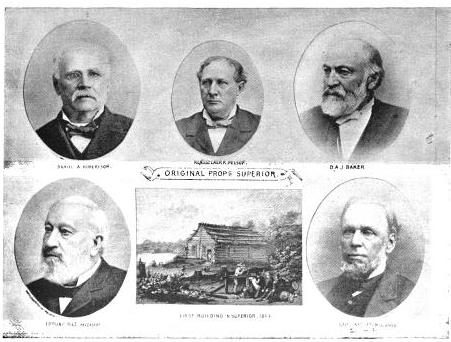
Original Proprietors of Superior featuring James Stinson, Benjamin Thomson, Dr. W.W. Coran, U.S. Senator Robert J Walker, George W. Cass, and Horace Bridge. Featured in The Eye of the North-west, pg. 8.
From the printed argument of Senator BRIGHT’S friend, and from a private abstract of the testimony in the case, and a few items I have picked up in the Land Office, I think it will be in my power to indite an epistle that may excite some attention. At the Southwestern extremity of Lake Superior, there is a tract of land, which is expected some day to become the cite of a large city. Being aware of its great advantages for this purpose, a St. Paul speculator by the name of THOMPSON, and a Canadian operator by the name of STINSON, undertook to possess themselves of it as long as as in the early part of General PIERCE‘S administration, by vicarious preemptions. In this plan they were assisted by some official gentlement, who shared in the spoils, and patents were ground out in double-quick time, or certificates issued to Swedes and Indians for the benefit of this STINSON and THOMPSON, and their associate speculators.
More Proprietors of Supeior from The Eye of the North-west, pg. 9.
In the Summer of 1854, this Mr. STINSON, headed a gang of Swedes and led them from Swede Lake, in the Territory of Minnesota, to Lake Superior, guiding them in person to the tracts he wished them to preempt. These men were ignorant of our language and of our laws, and were used by STINSON to “settle” their tracts, “prove up” their claims, and “convey” to him, the said STINSON, without knowing either the frauds they were practicing, or the rights which they might have secured to themselves if they had been acting in good faith. In the Land Office at Hudson, where these frauds were perpetrated, there was a notary public, who drew the deeds to STINSON, got the signatures of the Swedes to them and took the acknowledgements, immediately after the preemption oath had been administered – the Swedes thinking the whole operation a part of the preemption process. The terms were said to be $30 a month, and a bonus of $15 on the consummation of the bargain. The names of these Swedes were Aaron Peterson, Martin Larson, Peter Nelson, John Johnson, Sven Magnassan, Lorenz Johnson, Peter Norell, Sven Larson, Andreas Senson, Johannes Helon, Johannes Peterson, and Peter Erickson. These “preemptors,” for their own benefit, all “proved up” at Hudson, and the very same day they made conveyances to STINSON. The same thing is true of another Swedish invasion that was made in the Summer of 1855. In that year three Swedes – Old Westerland, Andrew Walmart, and Israel Janssen – commenced their settlements June 11, proved up June 22, and conveyed to STINSON June 22 – eleven days being sufficient for the whole operation. The records of the Land Office at Superior, and of the Register of Deeds of Douglas County, show these facts. They are well known in the General Land Office.
But Mr. STINSON did not operate through Swedes alone. He and his friend THOMPSON worked with half-breed Indians also. In March, 1854, he and THOMPSON followed up the Government Surveys with a gang of Chippewa half-breed Indians. The whole gang made preemptions in Douglas County, under the guidance of THOMPSON and STINSON, who hired them at La Pointe, and convered a large portion of a township with their fraudulent pre-emptions, which were proved up simultaneously, and simultaneously conveyed to the attorney of THOMPSON and STINSON. The names of all of this gang appear on the tract books in the General Land Office. These were Joseph Lamoureaux, Joseph Defaut, Joseph Dennis, Joseph Gauthier, Francis Decoteau, John B. Goslin, George D. Morrison and Levi B. Coffee, all preemptors for these land-sharks. There were three or four more half-breeds in the gang, who ran foul of some eight or ten American citizens who were seeking to save a slice of this Territory from Swedish and Indian preemption, and lay out a town site there under the law. This was the origin of the Superior City controversy, which has been pending some three or four years in the various land offices, and which has accumulated the basket of papers which first drew my attention to a case of such interesting dimensions. The contest is nominally between three or four Chippewa half-breeds claiming some three hundred acres as a town site. But the Indians are not merely bogus citizens, they are bogus pre-emptors in the bargain, for they were the hired men of THOMPSON & STINSON.
Mr. CUSHING decided in this controversy, before it was so settled by the Dred Scott case, that a half-breed Indian, receiving annuities as such, recognized as a dependent of a tribe, and the beneficiary of treaty stipulations, could become a citizen of the United States only by some positive act of Federal legislation ; that he could not, of his own volition, or by the laws of a State, change his condition from that of an Indian to that of a Federal citizen. Strange as it may seem, it appears that this part of the Dred Scott is repudiated by Mr. Commissioner HENDRICKS, who thinks a state cannot make a Federal citizen of a man with a drop of negro blood in his veins, but that the Commissioner of the General Land Office may naturalize Indians, ad libitum, without statute or judgement to sustain him.
I am curious to see how this controversy will be decided. The General Land Office upheld STINTSON’S Swedish preemption, on the ground that the frauds were discovered too late for the Commissioner to interefere. Whether or not STINSON hasmade any negro preemptions does not appear. It was too cold at the end of the lake for negroes to flourish much. But now it is to be settled in a case where the attempted frauds have been seasonably discovered, whether or not a Canadian adventurer can preempt whole townships of the Public Lands by the agency of a gang of half-breed Indians, and procure patents for them when the facts are known to the Federal authorities.
The pre-emptive right. Homesteads.
~ Superior, Wisconsin, papers, 1831-1942 ([unpublished])
Detail of Superior City townsite at the head of Lake Superior from Stuntz’s 1854 Plat Map of Township 49 North Range 14 West.
Early history of Superior should make mention of this right of acquisition, since there under, titles to government land were derived. Any qualified person might acquire title to one hundred and sixty acres of land by settling thereon, erecting a dwelling and making other improvements. Such person was to be twenty-one years of age, either male or female, or the head of a family whether man or woman.
Proof of each settlement was required to be made on a certain day at the United State Land Office and upon the payment of two hundred dollars with the taking of a required oath, the preemptioner got his one hundred and sixty acres of land.
But the whole proceeding, was far from straight, as a general thing, and in fact often amounted to a fraud.
“In the first place, Superior was backed by a powerful company of Democratic politicians and Government bankers in Washington, while the northern and northeastern portions of the state were still held by the Indians. This Superior company sought a connection with the Mississippi river, to obtain which they urged in congress the passage of a land grant bill, offering ten sections to the mile to aid in the construction of a railroad from Milwaukee to some point on Lake St. Croix, on the western boundary of the state of Wisconsin.”
~ History of Duluth and St. Louis County, Past and Present,
Volume 1, page 230.
Hence the whole country, in and about Superior, was dotted with preemption cabins, which were little more than logs piles up in walls, without floors, or windows, often with brush for a roof, a hole therein for a chimney and perhaps for a door. A slashing of half an acre or so of trees was the “improvement” so called. A very barbarous travesty, it was, upon a white man’s home and farm. Here is an instance, where as was said, a certain doctor of divinity laid claim to a quarter section of land, now in the midst of this city.
One day he sought “to prove up” his preemption, and one Alfred Allen was his witness, and they asked Allen, “Was the pre-emptions shanty good to live in?“, the law requiring a good habitable house on the claim. And Alf said “Yes, good for mosquitoes.” The Reverend said “Pshaw! Pshaw!” Meanding to upbraid or caution the witness who thereupon only protested and adjured the harder. The difficulty was somehow smoothed over, through some mending of the proofs, and perhaps connivance on the part of persons charged with administration of the United States land laws.
Nevertheless, it is interesting to member that upon rude and rough proceedings, such as are herein alluded to, rest at bottom the titles and claims to everything we own in the nature of lots, blocks, and land.
From: Statements of Hiram Hayes. Mr. Hayes came to Superior in 1854.
History of Duluth and St. Louis County, Past and Present, Volume 1
By Dwight Edwards Woodbridge, et al, 1910
GEORGE R. STUNTZ. [pages 229-231]
One of the earliest settlers at the head of the lakes was Mr. George E. Stuntz, who a short time ago joined the great majority. Before his death Mr. Stuntz wrote of his pioneer experiences as follows:
“In July, 1852, I came to the head of Lake Superior to run the land lines and subdivide certain townships. When I arrived at the head of the lakes there was nothing in Duluth or Superior. There was no settlement. The old American Fur Company had a post at La Pointe, at the west side of Madeline Island.
Detail of Minnesota Point from Stuntz’s Exterior Field Notes (August-October of 1852).
“In 1853 I got the range subdivided, and also in Superior, townsite 49, range 13. During the same year, later, in my absence, there came parties from the copper district of upper Michigan and located claims upon the range. They were principally miners. During the same year I built a residence on Minnesota Point under treaty license before the territory was sold to the Government. At that time there were only missionaries or license traders in the tract, as it belonged to the original Indian territory. In 1852, at Fond du Lac, there was a trading post and warehouse, in which I stored my goods on my arrival. In the fall of 1853 I bought three yoke of cattle and two cows at St. Croix Falls and brought them to the mouth of the Iron river, and had to cut a road thirty miles through the dense forest so as to get the oxen, cows and cart through. Later in the fall of 1853 I came through with an extra yoke of oxen, buying provisions, etc., and on coming up to Superior I found quite a settlement of log cabins. These settlers were anxious to get to the United States land office, then at Hudson, Wis. A dense forest intervened. We organized a volunteer company in January, 1854, to cut a road from old Superior to the nearest lumber camp on the St. Croix river, I furnishing two barrels of flour, provisions, pony and dog train, necessary to carry the provisions for a gang of seventeen men. The road was completed in twenty days, the snow being at that time two feet deep. This cut through a direct road to Taylor’s Falls and Stillwater. In 1854 I completed a mill on the Iron river and employed a man to superintend it, and I remained at Minnesota Point, my trading post, where I had first taken out the license. In the same year I took a contract to subdivide two townships located in Superior, townships 48-49, range 15, and afterward I attended the treaty at the time the Indians sold this country to the Government.
Before the 1854 Treaty of La Pointe could be ratified in Washington, D.C., the oral description agreed upon during the negotiations for exterior boundaries of the Chippewa treaties had to be surveyed with the tribe, documented, and delivered to Washington, D.C. before 1855. It is not clear who was involved with the exterior boundaries of these reservations; whether it was Stuntz, Barber, and/or others from their party.
“There were 5,000 Indians present with their chiefs. It was the biggest assemblage of Indians ever held at Lake Superior at this period of the country’s history. It took a month to pacify the troubles that grew among the different tribes in regard to their proportionate rights. This treaty was sent to congress September [30], 1854, and was ratified and became law in January, 1855.
To be continued in 1854…
Penokee Survey Incidents: Number VI
March 14, 2015
By Amorin Mello
December 22, 1877.
The Survey of the Penoka Range and Incidents Connected with its Early History.
—
Number VI.
At length, somewhere about the 25th of October, the General returned from below, accompanied by his son, Joseph Cutler, George Spaulding, a young man who had formerly been in his employ in Maine, and Henry C. Palmer of Milwaukee, a son of President Palmer, who all came to hold claims for the Company, if wanted. He also brought two cook stoves and two metal kettles, the stoves for housekeeping, the kettles for sugar making. Both of the kettles and one of the stoves were subsequently sent to the Range, where they did good service during the winter and following spring, and are no doubt in use somewhere in the country today.
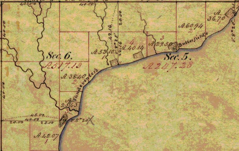
Houghton was a small settlement in the Town of BayPort, located northeast of what is now the City of Washburn. Captain Steven Butterfield and Peter B Vanderventer lived at what is now Washburn. (Detail from Augustus H. Barber’s survey during August of 1855)

Antoine Gordon from Noble Lives of a Noble Race (pg. 207) published by the St. Mary’s Industrial School in Odanah.
These kettles and stoves came very near sending Gen. Cutler, myself and Mr. Sidebotham, who had been stopping at La Pointe for several weeks, awaiting events, to a watery grave, during the run from that place to Ashland, in the Jane, a large two-masted boat formerly used by the Government upon the lake coast survey. Nothing but the coolness and skill of Captain Steve Butterfield, who was at the helm, saved us from going to the bottom. It was a long time before the recollections of that November day ceased to haunt us. The idea of going down in 150 feet of water with such a load, was not a pleasant thing to contemplate. Mr. Sidebotham was wholly unconscious, until after he reached the shore, of the peril we were in, owing to his ignorance of nautical affairs, but not so the General. He realized it as keenly as I did, not a word was spoken for over an hour, but in that hour we lived a lifetime. At length we succeeded in reaching the land at Houghton, where the high rocky shore furnished a lee. I shall never forget that ride while I live. We stopped for dinner at Antoine Gordon‘s, who lived at that time a little to the westward of Houghton, after which we ran down the shore to Pete Vanderventer‘s old place before venturing to cross the Bay to Ashland, which however, we finally did, reaching there in safety about sunset. Here we left Mr. Sidebotham to remain until wanted, and with J. Cutler, Palmer, and Spaulding, started the next morning for the Range, reaching there the second day at noon. Immediately upon our arrival, an interview was had with Stuntz, who informed us that if the fine weather we were then enjoying should continue for three weeks more, the survey to complete which he was making every possible exertion, would be finalized. This was to us indeed joyful news, as we were getting very anxious to return to our homes for the winter; whereupon all of our spare men were at once detailed to assist him, leaving me alone at Penoka, the General, in the meantime, visiting the different locations, and arranging for the winter, during which a blockhouse was to be built at Penoka, and one at the Gorge, which was done, the lumber for both being manufactured upon the ground, with a whip saw. Up to this time there had been no snow except the usual light fall we had every year, about the 1st of November. This, however, had all disappeared in three days after it fell, after which the weather was beautiful. In this way the time passed along, I seeing no one except Gen. Cutler, who came occasionally, or some of Stuntz’s men, who came for supplies, which were at this time kept mostly at Penoka, until the 12th of November, when it being certain that one week more would finish the survey, General Cutler left for Ashland, after Mr. Sidebotham, who by the requirements of the pre-emption law, must sleep upon his claim the 30th, in order to hold it, at least we so understood it at the time, leaving me entirely alone.
The weather continued fair up to the 18th, when there came a change. Saturday, the 17th, was as fine an Indian summer day as I ever saw, nearly all of which I slept seated upon a log in front of the cabin, listening to the singing of the birds, many of them not yet having left us for their homes in the south, and watching them as they were fitting around me, in search of food. At length old Sol sunk in the west, and night once more spread her dark mouth over the surrounding landscape. A strange feeling of loneliness, such as I had never felt before, crept over me as I closed the door of the cabin for the night, and sought my couch of balsam boughs, where I slept soundly until 6 o’clock the following morning, when presto! what a change met my eye! The air so soft and clear the previous evening, was now filled with snow, while upon the ground it was two and a half feet in depth, and increasing rapidly. You can easily imagine that I was not a little startled at the outlook, as being snowed in upon Lake Superior was no joke; and from the rapidity with which it was falling, it was apparent that it would be six feet in depth in twenty-four hours, if it kept on. I quickly saw that the first thing to be done was to lay in a supply of wood, the nearest pile of which was thirty rods distant. To this a track was quickly made, and the work of moving it commenced; neither did it stop until 2 P.M., at which time the whole pile, one and a half cords was in the cabin. The snow was now three feet in depth, but very light. My wood secured, I proceeded to cook some food, of which I felt the need, after which my thoughts began to wander after Stuntz and party, who were fifteen miles south. Neither did they reach the Range until the fourth day, as they had but one mile to run, in order to complete, when the storm came. This done, they started, and were three days in making that fifteen miles, during one of which, the last, they had nothing to eat, and one of them, Wilhelm Goetzenburg, literally nothing to wear, being clad in duck pants, hickory shirt, and stoga boots, no stockings, coat or vest. They were all badly used up when they got in; Stevens, in particular, who gave out when within only three miles of the Range, where he remained until his companions had reached the cabin, and two of them returned to him with some food, after which he came in, but as weak as to render it necessary to lead him. It was several days before he fully recovered his former strength. Goetzenburg, although nearly naked, stood it the best of them all. Perhaps a short sketch of this curious mortal, who certainly exhibited upon this occasion, powers of endurance equal to the gay and festive mule may not be inopportune, in this connection, before closing this article.
Wilhelm Goetzenburg, or Gutsenburg, as George Miller once spelt it when directing a letter for him to his “bruder” in Ontonagon, was not an Adonis, in the strict sense of the term. No sir! his keel was laid for a jumping jack, but from some unexplained cause, that plan was abandoned by his builder, who finally modeled him after the tubs the performing elephants use in the circus, broad at the base; in fact, his basement story was the largest part of him, in fact, nearly all of him; his legs, which were bowed, were short; his arms were long; his chest was short, and shaped like the dummies we see in the windows of ladies’ furnishing stores; his shoulders were broad, upon which a head covered with a thick mat of coarse hair, in color like that of a North Carolina clay-eater; a short nose, and a mouth that if open would have fooled a badger. Taken as a whole, he looked like a mixture of Low Dutch, Esquimaux and New Zealander combined. But beneath that iron frame, beat as honest a heart as ever beat in Ashland, or any other land. Good luck to thee, honest Wilhelm, I shall never see thy like again, but wherever thou arts or goest, may beans be plenty and clothing cheap. But en resume.
The fifth day brought Gen. Cutler from Ashland, accompanied by Mr. Sidebotham, George Kilburn, Sibley, Steve Sanborn, and George Miller, with the pack horses, who all came to break the road, except Sanborn, who came to stay through the winter. The boys had also now got in from the different claims, and the old cabin was full. Here they all remained for two days, when there came a thaw and melted the snow, after which Uncle George and Sibley returned to the Marengo, and George Miller with the horses to Ashland. The rest remained until the 30th, when their claims secured, and the arrangements for the winter completed. Mr. Arthur E. Wheelock was placed in charge of the week with J. Culter, Palmer, Steve Sanborn, Spaulding, and Elie Valliant, a French Canuck, formerly a resident at Ironton, a ship and house carpenter by trade, as companions. This done, Gen. Cutler and myself, Sidebotham, McClelland, Chase, and Al. Stevens accompanied by two of Stuntz’s men, whose names I have forgotten, left for home. We camped the first night at the Marengo, where the boys, as usual, hid the sugar from Mr. Sidebotham, reaching Ashland the second day. Here we remained for two days, when leaving Mr. Sidebotham, as previous stated, we took our departure, going directly across the bay upon the ice, for Pete Vanderventer’s. Before reaching the shore, however, Chase, who led the party, broke in, and came very near drowning, as in addition to his pack and snowshoes, which were also carried, he had on rubber boots, the legs of which held water enough to run a milk factory for a week. He was finally pulled out and inverted a few moments to let him drain, after which we proceeded, reaching Antoine Gordon’s at dark, and reached Bayfield the second day, the last six miles being made in an open boat, obtained, from the Indians at Sioux River, which was returned by Wheelock and William Pell, who had accompanied us thus far on the way.
From Bayfield to Superior City on snow shoes, occupied seven days, during which we camped on the snow every night. This, although a hard tramp, was very much enjoyed by all. The last three days our route lay along the shore of the lake, where many laughable scenes occurred in the way of tumbles from the ice bergs that lined the shore. From Superior City via St. Paul and La Crosse, to New Lisbon by stage, occupied nine days. From New Lisbon by cars to Milwaukee, one day, reaching that place Dec. 25, 1857. J.S.B.
Penokee Survey Incidents: Number V
March 4, 2015
By Amorin Mello
December 15, 1877.
The Survey of the Penoka Range and Incidents Connected with its Early History.
—
Number V.
~ History of Milwaukee, pg. 358
Friend Fifield:- The reader will no doubt remember that my last left us all anxiously awaiting the completion of the township surveys, which, up to this time, we had hoped would have been accomplished as soon, at least, as we were ready on our part, to “prove up.” But still the work lagged, and instead of being through and home in three months, as at first anticipated, it was now plainly seen that such was not to be the case. Three months had already elapsed since the work was commenced, yet the goal was apparently as far distant as over, and as we could not discharge our men, it was finally decided to explore the country south and west of the Range for the purpose of ascertaining, as far as possible, its adaption for a railroad from Milwaukee to the Range, as well as from the Range to Ashland, the latter of which must, of necessity, be built to move the iron. And in order that it might be properly done, Mr. Albert W. Whitcomb, a civil engineer of considerable experience, was sent up from Milwaukee, to superintend the work, who, after making one trip to the Range returned to Ashland and commenced his work by running what was afterwards known as the “Transit Line,” on account of its being run with that instrument. This line followed principally what was known as the Coburn Trail, which was the only one in use at that time by the company; crossing White River at Welton‘s mill, the Marengo at Sibley‘s, (now Martin Rhiem‘s.) and the outlet of Dr. Brunschweiler‘s old copper location, and thence to Ashland “Pond.” When it became evident that no good route could be found from that point to the Range on account of the heavy grades to be overcome, the work by transit was abandoned, and the balance was run by compass and chain only, simply to ascertain the exact distance in miles. This work, which should under ordinary circumstances, have been completed in ten days, occupied over a month, besides involving a large expenditure of money which might as well have been sunk in the ocean, as far as the Company was concerned, as no benefit whatever resulted from it except to the men employed in the work.
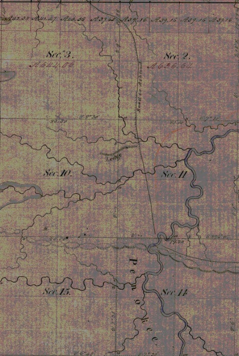
Palmer’s townsite claim located near Penokee Gap on Bad River with the “Coburn Trail” to Ashland. (Detail from Stuntz’s survey during May of 1858)
Subsequent, however, to the close of the survey upon the Transit Line, and the return of Mr. Whitcomb to Milwaukee, several extensive explorations were made to the south and west of the Range, by Gen. Cutler and myself, accompanied by Wheelock, Chas. Stevens, French Joe, (Joe Le Roy, with Big Joe as packer, and a Halfbreed called Little Alic as cook.) in one case nearly to the head waters of the Chippewa. These explorations, which were made with compass and chain, were by far the pleasantest part of my labors that summer, relieving us, as they did, not only of the monotony of camp life while awaiting the completion of the survey, but they also added largely to our knowledge of the topography, as well as the resources of the country south of the Range, then an unbroken wilderness, filled with beaver ponds, many of which were seen, but which is today, thanks to the energy and business tact of the gentlemen in charge of the Wisconsin Central railroad, beginning, metaphorically speaking, to bloom like the rose, and is destined, at no distant period, to take rank as one of the most wealthy and prosperous portions of our fair state. All honor to them for the same.
In this way our time was spent until September, when all homes of Stuntz being able to complete his work that season, unless some special providence should intervene, were abaonded, and preparations for spending the winter upon the Range were at once commenced. Gen Cutler immediately left for Milwaukee after additional supplies, first placing me in charge of the work. A pack train consisting of Stuntz’s pony, (old Jack) and Bascom‘s mare, were at once put upon the trail, in charge of Geo. Miller, a wild, harum-scarum Canuck from Canada West, who quickly stocked the Range with supplies.
But in order that the survey might yet be completed, if possible, additional men were put on, among whom was Wilhelm Goetzenburg, a Mechlinberger, at that time domiciled at Bay City and August Eckee, an old Courier de Bois, including all of our spare men, leaving me to keep camp at Penoka, which I did from about the middle of September to the 12th of October, during which time I saw no one except those who came in from the different claims at stated intervals, for supplies.
I see in your number of December 1, a reference by Hon. Asaph Whittlesey, to my sketch of Sibley and Lazarus, in which he not only confirms my statement, but goes one better in assigning him the belt as the champion liar, also which belt he (Sibley) was subsequently, however, compelled to surrender to John Beck. In consequence of Mr. Whittlesey’s statement I will relate one of Sibley’s yarns, told in the presence of Gen. Cutler, myself, Wheelock and a young man from St. Paul, by the name of Fargo, while eating dinner at his house on the Marengo, in August, 1857, which not only illustrates his powers as a yarn spinner, but the wonderful acoustic properties of his ears as well; being seated at the table, Sibley at once asked a blessing upon the food, for he could pray as well as lie, after which the question was asked by some one, how far it was possible to hear the human voice, upon which Sibley stated that he had not only heard the shouts of the people, but the words of the speaker also, distinctly, that were made at a political barbeque held in Ohio, in the fall of 1844, one hundred miles distant from where he was. Mr. Fargo, although no slouch of a liar himself, was so affected by this statement as to nearly faint, and finally made the remark that if that was not a lie, it came very near it; them lugs of Sibley’s were lugs as was lugs. Can John Beck beat that?

Harvey “Harry” Fargo was a cabinet maker, George R. Stuntz’s neighbor on the Minnesota Point in Duluth, an early mail carrier, and was in the 1853 census of Superior as “Arfargo.” ~ Duluth and St. Louis County, Minnesota; Their Story and People: An Authentic Narrative of the Past, with Particular Attention to the Modern Era in the Commercial, Industrial, Educational, Civic and Social Development, Volume 1, edited by Walter Van Brunt, 1921.
I wish to state at this time, also, a little incident in connection with Eckee, mentioned above, related to me by himself, which was this: That in the fall of 1846, he, in company with three others, in the employ of the Sigourney Lumber Co., of Quebec, ascended the river of the name three hundred miles in an open boat, for the purpose of cutting timber during the winter, and that when within three miles of their journey’s end, their boat was upset in a rapid, they barely escaping with their lives, but with the loss of the boat and all its contents, axes, fishing tackle and supplies. His companions, horrified at their situation, started immediately on their return, following the sinuosities of the river. He however, chose to remain, which he did until spring, never seeing a human face for six entire months. There were four oxen and two horses at the camp the care of which he claimed, kept him from going insane. It is needless to state that his companions were never heard from again. Although this incident has no immediate connection with my history, yet it serves to illustrate the hardships to which the class of men he belonged to are often called to suffer. He could never speak of that winter and its horrors, without tears.
But to return to the Range. Although I can truthfully say that the whole time spent upon the Range was to me one of unalloyed pleasure, yet that engaged during the latter part of September and up to the 20th of October, exceeded all the rest. The forest has, at all times, a charm for me, and the autumnal months doubly so; It is then and then only that its full glories can be seen; and in no country or section of country that it has ever been my privilege to visit, is the handiwork of Dame Nature’s gelid pencil, so grandly displayed as upon Lake Superior, and more particularly is this so, in and around the Range. No doubt the good people of Ashland think the scenery at the Gap very fine, and so it is. Yet that at the west end is far more so. Here the range terminates in a bold escarpment some 300 feet above the surrounding country, giving to an observer an unobstructed view east, west and south, for forty miles.
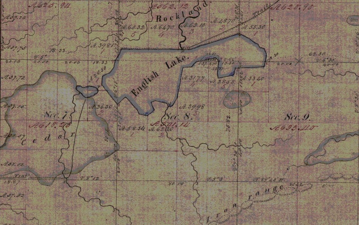
Indian trails to the “Rockland” townsite claim overlooking English Lake and the west end of the Penoka Range. Julius Austrian later claimed the “Rockland” site for his daughter’s estate.(Detail from Stuntz’s survey from May of 1858)
This was my favorite resort in those beautiful autumn mornings, where, seated upon the edge of the bluff, I would feast my eyes for hours upon that matchless panorama. Neither could I ever divest myself of the feeling that, while there, I was alone with God. I have seen, in the course of my life, many landscape paintings that were very beautiful, but never one that could at all compare with the views I enjoyed in the months of October 1857, from the west end of the Penoka Range. J.S.B.
Penokee Survey Incidents: Number IV
February 22, 2015
By Amorin Mello
December 8, 1877.
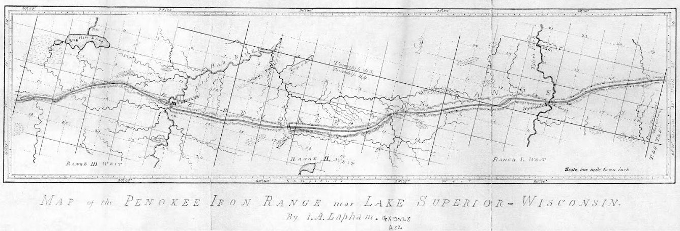
Increase Allen Lapham surveyed the Penokee Iron Range in September of 1858 for the Wisconsin & Lake Superior Mining and Smelting Company. Years later, Lapham’s experience was published as “Mountain of Iron Ore: The buried wealth of Northern Wisconsin“ in the Milwaukee Evening Wisconsin newspaper on February 21, 1887. (Image courtesy of the University of Wisconsin Geography Department)
~ 1978 Marsden Report for US Steel.
~ Railroad History, Issues 54-58, pg. 26
The Penoka Iron Range consists, as is well known, of a sharp ridge, some fifteen miles in length, by from one to one and one half in breadth, with a mean elevation of 700 feet above Lake Superior, from which is a distance about twenty-two miles, as the crow flies, its general trend being nearly east and west, it is densely covered with timber consisting of sugar maple, (of which nearly every tree is birdseye or curly) elm, red cedar, black, or yellow birch, some of which are of an enormous girth, among which are intermixed a few white pine and balsams, for it is traversed from north to south at three different points, by running streams, upon each of which the company had a station, the western being known in the vernacular of the company, as Palmer’s, (now Penoka); the center, as Lockwood’s, in honor of John Lockwood, who was at the time a prominent member of the Company, and upon its executive board; and the eastern, as Sidebotham’s, or “The Gorge.” These were the principal stations or centers, where supplies and men were always kept, and as which, as before stated, more or less work had been done the previous year. Penoka, as which the most work had been done, being considered by far the most valuable. This post was, at the time of my first visit, by charge of S.R. Marston, of whom mention was made in my last, and two young boys from Portsmouth, N.H., who had come west on exhibition, I should say, from the way they acted. They soon left, however, too many mosquitoes for them. “Lockwood’s,” as previously stated, was garrisoned by one man, whose name I have forgotten, and although a great amount of work had been done here as yet, it was nevertheless considered a very valuable claim, on account of the feasibility with which it could be reached by the rail Mr. Herbert had in contemplation to build from Ironton, and which would, in passing along the north side of the Range, come in close proximity to this station; besides, it had the additional advantages of a fine water power. At the east end were two half-breeds employed by the company, and George Chase, a young man from Derby, Vermont, a nephew of ex-Mayor Horace, and Dr. Enoch Chase, of Milwaukee, an employee of Stuntz, who, with James Stephenson, was awaiting the return of Gen. Cutler with reinforcements, in order to continue the survey. Chase subsequently made a claim which he was successful in securing – selling it finally to the Mr. Cogswell, of Milwaukee.
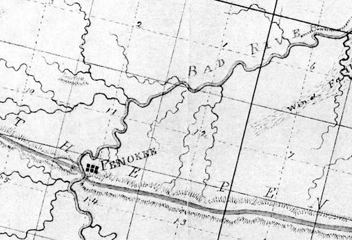
Penoka, aka Penokee, is Palmer’s station near the Bad River Gap.
It is also proper to state in addition to what has been already mentioned, that at, or about this time, a road was opened by Mr. Herbert’s order, from the Hay Marsh, six miles out from Ironton, to which point one had been previously opened, to the Range, which it struck about midway between Sidebotham’s and Lockwood’s Stations, over which, I suppose, the 50,000 tons as previously mentioned, was to find its way to Ironton, (in a horn). For this work, however, the Company refused to pay, as they had not authorized it; neither had Mr. Herbert, at that time, any authority to contract for it, except at his own risk; his appointment as agent having already been revoked; although his accounts had not, as yet, been fully settled. This work, which was without doubt, intended to commit the company still further in favor of Ironton as an outlet for the iron, was done by Samuel Champner, a then resident of Ashland and who if living is probably that much out of pocket today. No use was ever made of this road by the Company, not one of their employees, to my knowledge, ever passing over it.

The location of Lockwood’s station was not mapped by Lapham or by Stuntz. City Creek and Ballou Creek are the two water gaps on either side of Mount Whittlesey, midway between the gaps of Bad River and Tyler’s Fork.
This description will, I think, give your readers a very good understanding of the condition as well as the true inwardness of the affairs of the Wisconsin & Lake Superior Mining and Smelting Co., in the month of June, 1857.
At length, after remaining on the Range nearly three weeks, awaiting, Micawber like, for something to turn up, a change came with the arrival of Gen. Cutler from Milwaukee with the expected reinforcements. Mr. Herbert at once left the Range, went to Milwaukee and settled up with the Company, after which, to use a scriptural expression, “he walked no more with us.”

Springdale is Sidebotham’s station at The Gorge of Tyler Fork’s River.
“A special defense in contract law to allow a person to avoid having to respect a contract that she or he signed because of certain reasons such as a mistake as to the kind of contract.”
~ Duhaime.org
Wheelock, Smith, and McClellan were at once placed upon claims – McClellan in the interest of John Cummings, (whose name by an oversight was also omitted from the list of stockholders, given in my first paper), and Wheelock and Smith for the Company generally. Subsequently, A.S. Stacy, of Canada, was also employed to hold a claim. How well he performed this duty, will be seen further on. This done, the improvements necessary to be made in order to entitle us to the benefits of the preemption law were at once commenced. These improvements consisted of log cabins, principally, of which some twenty in all were erected upon the different claims. These cabins would have been a study for Michel Angelo, or Sir Christopher Wren. They had more angles than the Forty-seventh Problem of Euclid, with an average inclination of fifteen degrees to the Ecliptic. O, but they were “fearfully and wonderfully made,” were these cabins. Their construction embodied all the principle points of architecture in the Ancient as well as Modern–Milesian-Greek, mixed with the “hoop skirt” and Heathen Chimee. Probably ten dollars a month would have been considered a high rent for any of them. No such cabins as those were in exhibition at the Centennial, no sir. Rome was not built in a day, but most of these cabins were. I built four myself near the Gorge, in a day, with the assistance of two halfbreeds, but was not able to find them a week afterwards. This is not only a mystery but a conundrum. I think some traveling showman must have stolen them; but although they were non est we could swear that we had built them, and did.
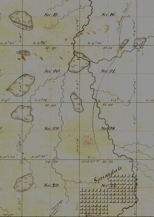
Springdale townsite plan at Sidebotham’s station by The Gorge of Tyler’s Fork in close proximity to the Ironton Trail and Iron Range. (Detail of Stuntz’s survey during August of 1857.)
Three were accordingly platted — one at Penoka, one at Lockwood‘s and one at the Gorge. And in order that it might be done without interfering with the regular survey, Gen. Cutler decided to place S.R. Marston who, in addition to his other accomplishments, claimed to be a full-fledged surveyor, in charge of the work, assisted by Wheelock, Smith and myself. He commenced at the Gorge, run three lines and quit, fully satisfied that he had greatly overestimated his abilities. We were certainly satisfied that he had. A drunken man could have reeled it off in the dark and come nearer the corner than he did. He was a complete failure in every thing he undertook. He left in the fall after the failure of the Sioux Scrip plot. Where he went I never knew. George E. Stuntz was subsequently put upon the work, which he was not long in doing, after which he rejoined Albert on the main work. This main work, however, for the completion of which we were all so anxious, was very much delayed, the cause for which we did not at the time fully understand, but we did afterwards. J.S.B.
Penokee Survey Incidents: Number II
February 12, 2015
By Amorin Mello
November 24, 1877.
The Survey of the Penoka Range and Incidents Connected with its Early History
—
Number II.
Friend Fifield:– Notwithstanding the work upon the Range was delayed very much on account of the unwoodsman like conduct of the Milwaukee boys, referred to in my first communication, yet it did not cease,- the company having a few white men, previous employed, as well as a large number who were “to the Mannor born” that did not show the “white feather” on account of the mosquitos, gnats, gad flies and other vermin with which the woods were filled,– most of whom remained with us to the end.
Prominent among these last named was Joseph Houle, or “Big Joe” as he was usually called,– a giant halfbreed, (now dead), who was invaluable as a woodsman and packer. Some idea of Joe’s immense strength and power of endurance may be formed from the fact that he carried upon one occasion the entire contents, (200 lbs.) of a barrel of pork from Ironton to the Range without seeming to think it much of a feat. Among the party along on this trip was a young man taking his first lesson in woodcraft, whose animal spirits cropped out to such a degree that the leader caused to be placed upon his back a bushel of dried apples (33 lbs.), simply to keep him from climbing the trees, but before he reached the Range, his load, light as it was, proved too much for him, when Joe, in charity, relieved him of it, adding it to his own pack – making it 233 lbs. This was, without doubt the largest pack ever carried to the Range by any one man. There was an Indian, however, in the employ of the company, as a packer, (“Old Batteese“), who left Sidebotham‘s claim one morning at 7 A.M., went to Ironton and was back again to camp at 7 P.M. with 126 lbs. of pork, having traveled forty-two miles in ten hours. This was in July ’57, and was what I considered the biggest day’s work ever done for the company. The usual load, however, for a packer, was from sixty to eighty pounds.

Ironton townsite claim at Saxon Harbor with trails to Odanah and the Penoka Iron Range. (Detail from Wisconsin Public Land Survey Records)
The halfbreeds were sulky and mutinous at times, giving us some trouble, until Gen. Cutler, who was a strict disciplinarian, gave them a lesson that they did not soon forget and which occurred at follows:
The General and myself left Ironton just before the removal of our supplies to Ashland, with four of these boys, with provisions for the Range, to be delivered at Lockwood’s Station. But upon reaching Sidebotham’s, two of them refused to proceed any further, threw down their packs, and started on their return to Ironton. The General’s blood was up in a moment, and directing me to remain with the others until he returned, at once started after them. Reaching Ironton at 11 A.M., about an hour after their arrival, they were quite surprised at seeing him, but said nothing. The General at once directed Duncan Sinclair, who had charge of the supplies at that time, to make up two packs of one hundred pounds each, with ropes in place of the usual leathern strap, which was quickly done, the “rebels” looking sullenly on all the while. When all was ready he drew his revolver and ordered them to pick them up and start. They did not wait for a second order, but took them and started, he followed immediately behind. Nor did he let them lay them down again until they reached Lockwood’s at sunset, a distance of twenty-six miles. – That evening they were the most completely used up men I ever saw on the Range, and from that time forward were as submissive and obedient as could be desired. After that we never had any trouble. It was a lesson they never forgot.
Among the whites referred to in this article, was James Stephenson, a young man from Virginia, who came up with Stuntz as a surveyor. He was of light build, wiry and muscular – full of fun – very excitable and nervous, – but a good man for the woods. He had some knowledge of the compass, but not sufficient education to make a good surveyor. “Jim” got lost once and was out three days before he came into camp, which he did just as the party was starting out to find him. “Jim” would not have made a good rope walker. He was no Blondin. On the ground he was all right, but let him attempt to cross a stream of water, be it ever so small, upon a log, no matter if the log was six feet in diameter, and he would fall in sure. He fell in twice while lost and came near perishing with wet and cold in consequence of it. He left the company in the fall of ’57.
But the best man we had on the range that summer, as a surveyor, (except Albert Stuntz, and I very much doubt if he could beat him), was George E. Stuntz, a nephew of Albert’s, known among the boys as “Lazarus.” He was tall and slim, with a long thin face, blue eyes, long dark brown hair, stooped slightly when walking; walked with a swinging motion, spoke slow and loud – was fond of the woods, prided himself on his skill with the compass, and was, I think, the laziest man at that time in the county, except “Sibly,” who could discount him fifty and then beat him. But notwithstanding all this Albert could not have completed his survey that season without him. His lines never required any corrections. George was a singer – or thought he was, which is all the same. The recollections of some of his attempts in this line almost brings tears to my eyes from laughter, even now. Nearly every night in camp, the boys, after getting into a position where they could laugh without his seeing them, would coax him to sing. His favorite piece was a song called “The Frozen Limb.” What it meant I have no idea, and do not think he had. One verse of this only can I recall to mind, which ran as follows:
“One cold, frosty evening as Mary was sleeping –
Alone in her chamber, all snugly in bed. – She woke with a noise that did sorely affright her.
‘Who’s that at my window?’ she fearfully said.”
You can easily imagine how this would sound when sung through the nose in the hard shell style – each syllable ending with a jerk, something like this:
“Who’s-that-at-my-win-dow-she-fear-ful-ly-said-ud.”
George had a suit of clothes for the woods made of bed ticking, cap and all complete – all but the cap in one piece. The cap was after the “Dunce” pattern, ie, it ran to a point. The stripes instead of running up and down as they should have done, ran diagonally around him, giving him the appearance of a walking barber’s pole. He was a nice looking boy – he was.
Shortly after donning this beautiful suit, while crossing the Range, he suddenly found himself face to face with a full grown bear. It was no doubt a surprise to both parties,– it certainly was to the bear. For he took one square look and left for distant lands at a speed which, if kept up, would have carried him to Mexico in two days. “Not any of that in mine” was probably what was passing through his massive brain, but he made no sign. The boys who were surveying some fifteen miles south of the Range claimed to have met him that day, still on the jump. J.S.B.
Penokee Survey Incidents: Number I
February 8, 2015
By Amorin Mello
The Ashland Weekly Press is now the Ashland Daily Press.
November 10, 1877
For the Ashland Press
The Survey of the Penoka Iron Range and Incidents Connected With Its Early History.
—
James Smith Buck (1812-92) “For 19 years, Buck was a building contractor, erecting many of the city’s earliest structures. He is best known for his writings on early Milwaukee history. From 1876 to 1886, he published a four-volume History of Milwaukee, filled with pioneer biographies and reminiscences.” (Forest Home Cemetery)
Friend Fifield:- Being one of the patrons and readers of your valuable paper, and having within the past year noticed several very interesting and well written articles entitled “Early Recollections of Ashland” in its columns, and more particularly one from a Milwaukee correspondent, in a recent number, in which my name, with others, was mentioned as having done some pioneer work in connection with your young city, I thought that a few lines in the way of a “Reminiscence” from me as to how and by whom the Penoka Range was first surveyed and located, might be interesting to some of your readers,- if you think so, please give this a place in your paper and oblige.
Truly Yours,
J.S. Buck.
I first visited Lake Superior in the month of May, 1857, in the interest of the Wisconsin and Lake Superior Mining and Smelting Co., a charter for the organization of which had been procured the previous winter.– This company was composed of the following gentlemen: Edwin Palmer, Gen. Lysander Cutler, Horatio Hill, Jas. F. Hill, Dr. J.P. Greves, John Lockwood, John L. Harris, John Sidebotham, Franklin J. Ripley and myself. Edwin Palmer, President, J. F. Hill, Secretary – with a capital of (I think) $60,000. Our first agent was Mr. Milliam Herbert, with headquarters at Ironton, where some five thousand dollars of the company’s money was invested in the erection of a block-house and a couple of cribs intended as a nucleus for a pier – and in other ways – all of which was subsequently abandoned and lost – the place having no natural advantages, or unnatural either, for that matter.– But so it is ever with the first and often with the second installments that such greenies as we were, invest in a new country; for so little did we know of the way work was done in that country that we actually supposed the whole thing would be completed in three months and the lands in our possession. But what we lacked in wisdom, we made up in pluck — neither did we “lay down the shubble and de hoe,” until the goal was reached and the Penoka Iron Range secured – costing us over two years time and $25,000 in money.
The company not being satisfied with Mr. Herbert as agent, he was removed and Gen. Cutler appointed in his place, who quickly selected Ashland as headquarters, to which place all the personal property, consisting of merchandise principally, was removed during the summer by myself upon Gen. C.’s order – and Ironton abandoned to its fate.
~ Captain Robinson Derling Pike (Bayfield 50th anniversary celebrations)
The company at this time having become not only aware of the magnitude of the work they had undertaken, but were also satisfied that Ashland was the most feasible point from which to reach the Range, as well as the place where the future Metropolis of the Lake Superior country must surely be — notwithstanding the “and to Bayfield“ clause in that wonderful charter of H.M. Rice.
The cost of getting provisions to the Range was enormous – it being for the first season all carried by packers – every pound transported from Ashland to the Range costing from five to eight cents as freight.
This was my first experience at surveying as well as Mr. Sidebotham’s, and although I took to it easily and enjoyed it, he never could. He was no woodsman; could not travel easily, while on the other hand I could outwalk any white man except S.S. Vaughn in the country. He was then in his prime and one of the most vigorous and muscular men I ever met; but I think he will tell you that in me he found his match.
By our contract with Albert Stuntz we were not only to pay him a bonus equal to what he received per mile from Government, but we were also to furnish men for the work and see him through. In accordance with this agreement some eighteen men and boys, to be used as axemen and chainmen, were brought up from Milwaukee who were as “green as gaugers” and as the sequel proved, about as honest. A nice looking lot they were, when landed upon the dock at La Pointe, out of which to make woodsmen. I think I see them now, shining boots,– plug hats, with plug ugly heads in them, (at least some of them had), the notorious Frank Gale, Mat. Ward and one or two other noted characters being of the number. Their pranks astonished the good people of La Pointe not a little, but they astonished Stuntz more. One half day in the woods satisfied them – they were afraid of getting lost. In less than two weeks they had nearly all deserted and the work had to be delayed until a new squad could be obtained from below.
But I must close. In my next I will give you an account of my life on the Range. J.S.B.
