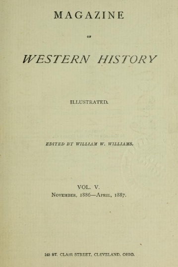
Colonel Charles Whittlesey
May 27, 2016
By Amorin Mello

C.C. Baldwin was a friend, colleague, and biographer of Charles Whittlesey.
~ Memorial of Charles Candee Baldwin, LL. D.: Late President of the Western Reserve Historical Society, 1896, page iii.
This is a reproduction of Colonel Charles Whittlesey’s biography from the Magazine of Western History, Volume V, pages 534-548, as published by his successor Charles Candee Baldwin from the Western Reserve Historical Society. This biography provides extensive and intimate details about the life and profession of Whittlesey not available in other accounts about this legendary man.
Whittlesey came to Lake Superior in 1845 while working for the Algonquin Mining Company along the Keweenaw Peninsula’s copper region. His first trip to Chequamegon Bay appears to have been in 1849 while doing do a geological survey of the Penokee Mountains for David Dale Owen. Whittlesey played a dramatic role in American settlement of the Chequamegon Bay region. Whittlesey convinced his brother, Asaph Whittlesey Jr., to move from the Western Reserve in 1854 establish what became the City of Ashland at the head of Chequamegon Bay as a future port town for extracting and shipping minerals from the Penokee Mountains. Whittlesey’s influence can still be witnessed to this day through local landmarks named in his honor:
Whittlesey published more than two hundred books, pamphlets, and articles. For additional research resources, the extensive Charles Whittlesey Papers are available through the Western Reserve Historical Society in two series:
Magazine of Western History, Volume V, pages 534-548.
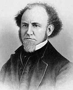
COLONEL CHARLES WHITTLESEY.

Map of the Connecticut Western Reserve in Ohio by William Sumner, September 1826.
~ Cleveland Public Library
![Asaph Whittlesey [Sr], Late of Tallmadge, Summit Co., Ohio by Vesta Hart Whittlesey and Susan Everett Whittlesey, né Fitch, 1872.](https://chequamegonhistory.com/wp-content/uploads/2016/05/asaph-whittlesey-vesta-hart.jpg)
[Father] Asaph Whittlesey [Sr], Late of Tallmadge, Summit Co., Ohio by [mother] Vesta Hart Whittlesey [posthumously] and [stepmother] Susan Everett Whittlesey, né Fitch, 1872.
~ Archive.org
War was then in the west, and his neighbors feared they might be the victims of the scalping knife. But the danger was different. In passing the Narrows, between Pittsburgh and Beaver, the wagon ran off a bank and turned completely over on the wife and children. They were rescued and revived, but the accident permanently impaired the health of Mr. Whittlesey.
Mr. Whittlesey was in Tallmadge, justice of the peace from soon after his arrival till near the close of his life, and postmaster from 1814, when the office was first established, to his death. He was again severely injured, but a strong constitution and unflinching will enabled him to accomplish much. He had a store, buying goods in Pittsburgh and bringing them in wagons to Tallmadge; and an ashery; and in 1818 he commenced the manufacture of iron on the Little Cuyahoga, below Middlebury.
The times were hard, tariff reduced, and in 1828 he returned to his farm prematurely old. He died in 1842. Says General Bierce,
“His intellect was naturally of a high order, his religious convictions were strong and never yielded to policy or expediency. He was plain in speech, sometimes abrupt. Those who respected him were more numerous than those who loved him. But for his friends, no one had a stronger attachment. His dislikes were not very well concealed or easily removed. In short, he was a man of strong mind, strong feelings, strong prejudices, strong affections and strong attachments, yet the whole was tempered with a strong sense of justice and strong religious feelings.”
[Uncle] Elisha Whittlesey
~ Collection of the U.S. House of Representatives

Portrait of Reverend David Bacon from ConnecticutHistory.org:
“David Bacon (1771 – August 27, 1817) was an American missionary in Michigan Territory. He was born in Woodstock, Connecticut. He worked primarily with the Ottawa and Chippewa tribes, although they were not particularly receptive to his Christian teachings. He founded the town of Tallmadge, Ohio, which later became the center of the Congregationalist faith in Ohio.”
~ Wikipedia.org
Tallmadge was settled in 1808 as a religious colony of New England Congregationalists, by a colony led by Rev. David Bacon, a missionary to the Indians. This affected the society in which the boy lived, and exercised much influence on the morality of the town and the future of its children, one of whom was the Rev. Leonard Bacon. Rev. Timlow’s History of Southington says, “Mr. Whittlesey moved to Tallmadge, having become interested in settling a portion of Portage county with Christian families.” And that he was a man “of surpassing excellence of character.”
If it should seem that I have dwelt upon the parents of Colonel Whittlesey, it is because his own character and career were strongly affected by their characters and history. Charles, the son, combined the traits of the two. He commenced school at four years old in Southington; the next year he attended the log school house at Tallmadge until 1819, when the frame academy was finished and he attended it in winter, working on the farm in summer until he was nineteen.
The boy, too, saw early life on foot, horseback and with ox-teams. He found the Indians still on the Reserve, and in person witnessed the change from savage life and new settlements, to a state of three millions of people, and a large city around him. One of Colonel Whittlesey’s happiest speeches is a sketch of log cabin times in Tallmadge, delivered at the semi-centennial there in 1857.
~ Annual Report on the Geological Survey of the State of Ohio: 1837 by Ohio Geologist William Williams Mather, 1838, page 22.
In 1827 the youngster became a cadet at West Point. Here he displayed industry, and in some unusual incidents there, coolness and courage. He graduated in 1831, and became brevet second lieutenant in the Fifth United States infantry, and in November started to join his regiment at Mackinaw. He did duty through the winter with the garrison at Fort Gratiot. In the spring he was assigned at Green Bay to the company of Captain Martin Scott, so famous as a shot. At the close of the Black Hawk War he resigned from the army. Though recognizing the claim of the country to the services of the graduates of West Point, he tendered his services to the government during the Seminole Mexican war. By a varied experience his life thereafter was given to wide and general uses. He at first opened a law office in Cleveland, Ohio, and was fully occupied in his profession, and as part owner and co-editor of the Whig and Herald until the year 1837. He was that year appointed assistant geologist of the state of Ohio. Through very uneconomical economy, the survey was discontinued at the end of two years, when the work was partly done and no final reports had been made. Of course most of the work and its results were lost. Great and permanent good indeed resulted to the material wealth of the state, in disclosing the rich coal and iron deposit of southeastern Ohio, thus laying the foundation for the vast manufacturing industries which have made that portion of the state populous and prosperous. The other gentlemen associated with him were Professor William Mather as principal; Dr. Kirtland was entrusted with natural history. Others were Dr. S. P. Hildreth, Dr. Caleb Briggs, Jr., Professor John Locke and Dr. J. W. Foster. It was an able corps, and the final results would have been very valuable and accurate. In 1884, Colonel Whittlesey was sole survivor and said in this Magazine:
“Fifty years since, geology had barely obtained a standing among the sciences even in Europe. In Ohio it was scarcely recognized. The state at that time was more of a wilderness than a cultivated country, and the survey was in progress little more than two years. It was unexpectedly brought to a close without a final report. No provision was made for the preservation of papers, field notes and maps.”
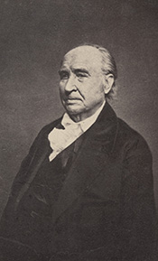
Report of Progress in 1869, by J. S. Newberry, Chief Geologist, by the Geological Survey of Ohio, 1870.
Professor Newbury, in a brief resume of the work of the first survey (report of 1869), says the benefits derived “conclusively demonstrate that the geological survey was a producer and not a consumer, that it added far more than it took from the public treasury and deserved special encouragement and support as a wealth producing agency in our darkest financial hour.” The publication of the first board, “did much,” says Professor Newberry, “to arrest useless expenditure of money in the search for coal outside of the coal fields and in other mining enterprises equally fallacious, by which, through ignorance of the teachings of geology, parties were constantly led to squander their means.” “It is scarcely less important to let our people know what we have not, than what we have, among our mineral resources.”

“Descriptions of Ancient Works in Ohio. By Charles Whittlesey, of the late Geological Corps of Ohio.”
~ Smithsonian Contributions to Knowledge, Volume III., Article 7, 1852.
The topographical and mathematical parts of the survey were committed to Colonel Whittlesey. He made partial reports, to be found in the ‘State Documents’ of 1838 and 1839, but his knowledge acquired in the survey was of vastly greater service in many subsequent writings, and, as a foundation for learning, made useful in many business enterprises of Ohio. He had, during this survey, examined and surveyed many ancient works in the state, and, at its close, Mr. Joseph Sullivant, a wealthy gentleman interested in archaeology, residing in Columbus, proposed that, he bearing the actual expense, Whittlesey should continue the survey of the works of the Mound Builders, with a view to joint publication. During the years 1839 and 1840, and under the arrangement, he made examination of nearly all the remaining works then discovered, but nothing was done toward their publication. Many of his plans and notes were used by Messrs. Squier & Davis, in 1845 and 1846, in their great work, which was the first volume of the Smithsonian Contributions, and in that work these gentlemen said:
“Among the most zealous investigators in the field of American antiquarian research is Charles Whittlesey, esq., of Cleveland, formerly topographical engineer of Ohio. His surveys and observations, carried on for many years and over a wide field, have been both numerous and accurate, and are among the most valuable in all respects of any hitherto made. Although Mr. Whittlesey, in conjunction with Joseph Sullivant, esq., of Columbus, originally contemplated a joint work, in which the results of his investigations should be embodied, he has, nevertheless, with a liberality which will be not less appreciated by the public than by the authors, contributed to this memoir about twenty plans of ancient works, which, with the accompanying explanations and general observations, will be found embodied in the following pages.
“It is to be hoped the public may be put in possession of the entire results of Mr. Whittlesey’s labor, which could not fail of adding greatly to our stock of knowledge on this interesting subject.”

“Marietta Works, Ohio. Charles Whittlesey, Surveyor 1837.”
~ Smithsonian Contributions to Knowledge, Volume I., Plate XXVI.
It will be seen that Mr. Whittlesey was now fairly started, interested and intelligent, in the several fields which he was to make his own. And his very numerous writings may be fairly divided into geology, archaeology, history, religion, with an occasional study of topographical geology. A part of Colonel Whittlesey’s surveys were published in 1850, as one of the Smithsonian contributions; portions of the plans and minutes were unfortunately lost. Fortunately the finest and largest works surveyed by him were published. Among those in the work of Squier & Davis, were the wonderful extensive works at Newark, and those at Marietta. No one again could see those works extending over areas of twelve and fifteen miles, as he did. Farmers cannot raise crops without plows, and the geography of the works at Newark must still be learned from the work of Colonel Whittlesey.
~ Smithsonian Contributions to Knowledge, Volume XIII., Article IV., page 2 of “Ancient Mining on the Shores of Lake Superior” by Charles Whittlesey.
He made an agricultural survey of Hamilton county in 1844. That year the copper mines of Michigan began to excite enthusiasm. The next year a company was organized in Detroit, of which Colonel Whittlesey was the geologist. In August they launched their boat above the rapids of the Sault St. Marie and coasted along the shore to where is now Marquette. Iron ore was beneath notice, and in truth was no then transportable, and they pulled away for Copper Harbor, and then to the region between Portage lake and Ontonagon, where the Algonquin and Douglas Houghton mines were opened. The party narrowly escaped drowning the night they landed. Dr. Houghton was drowned the same night not far from them. A very interesting and life-like account of their adventures was published by Colonel Whittlesey in the National Magazine of New York City, entitled “Two Months in the Copper Regions.” From 1847 to 1851 inclusive, he was employed by the United States in the survey of the country around Lake Superior and the upper Mississippi, in reference to mines and minerals. After that he spent much time in exploring and surveying the mineral district of the Lake Superior basin. The wild life of the woods with a guide and voyageurs threading the streams had great attractions for him and he spent in all fifteen seasons upon Lake Superior and the upper Mississippi, becoming thoroughly familiar with the topography and geological character of that part of the country.

“Pictograph C. Okundekund [Okandikan] and his Band of Ontonagon – Michigan,” as reproduced from birch bark by Seth Eastman, and published as Plate 62 in Historical and Statistical Information Respecting the History, Condition, and Prospects of the Indian Tribes of the United States, Volume I., by Henry Rowe Schoolcraft, 1851. This was one of several pictograph petitions from the 1849 Martell delegation:
“By this scroll, the chief Kun-de-kund of the Eagle totem of the river Ontonagon, of Lake Superior, and certain individuals of his band, are represented as uniting in the object of their visit of Oshcabewis. He is depicted by the figure of an eagle, Number 1. The two small lines ascending from the head of the bird denote authority or power generally. The human arm extended from the breast of the bird, with the open hand, are symbolic of friendship. By the light lines connecting the eye of each person with the chief, and that of the chief with the President, (Number 8,) unity of views or purpose, the same as in pictography Number 1, is symbolized. Number 2, 3, 4, and 5, are warriors of his own totem and kindred. Their names, in their order, are On-gwai-sug, Was-sa-ge-zhig, or The Sky that lightens, Kwe-we-ziash-ish, or the Bad-boy, and Gitch-ee-man-tau-gum-ee, or the great sounding water. Number 6. Na-boab-ains, or Little Soup, is a warrior of his band of the Catfish totem. Figure Number 7, repeated, represents dwelling-houses, and this device is employed to deonte that the persons, beneath whose symbolic totem it is respectively drawn, are inclined to live in houses and become civilized, in other words, to abandon the chase. Number 8 depicts the President of the United States standing in his official residence at Washington. The open hand extended is employed as a symbol of friendship, corresponding exactly, in this respect, with the same feature in Number 1. The chief whose name is withheld at the left hand of the inferior figures of the scroll, is represented by the rays on his head, (Figure 9,) as, apparently, possessing a higher power than Number 1, but is still concurring, by the eye-line, with Kundekund in the purport of pictograph Number 1.”
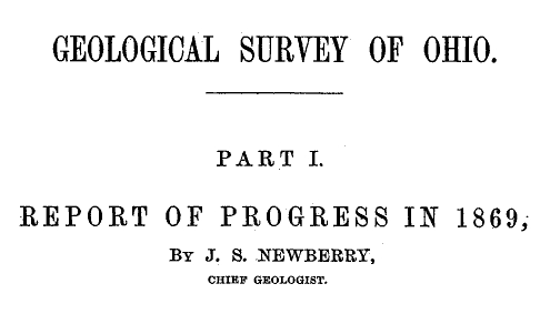
“Studio portrait of geologist Charles Whittlesey dressed for a field trip.” Circa 1858.
~ Wisconsin Historical Society
His detailed examination extended along the copper range from the extreme east of Point Keweenaw to Ontonagon, through the Porcupine mountain to the Montreal river, and thence to Long lake in Wisconsin, a distance of two hundred miles. In 1849, 1850 and 1858 he explored the valley of the Menominee river from its mouth to the Brule. He was the first geologist to explore the South range. The Wisconsin Geological Survey (Vol. 3 pp. 490 and 679) says this range was first observed by him, and that he many years ago drew attention to its promise of merchantable ores which are now extensively developed from the Wauceda to the Commonwealth mines, and for several miles beyond. He examined the north shore from Fond du Lac east, one hundred miles, the copper range of Minnesota and on the St. Louis river to the bounds of our country. His report was published by the state in 1865, and was stated by Professor Winchill to be the most valuable made.
All his geological work was thorough, and the development of the mineral resources which he examined, and upon which he reported, gave the best proofs of his scientific ability and judgment.

“Outline Map Showing the Position of the Ancient Mine Pits of Point Keweenaw, Michigan by Charles Whittlesey.”
~ Smithsonian Contributions to Knowledge, Volume XIII., Article IV., frontpiece of “Ancient Mining on the Shores of Lake Superior” by Charles Whittlesey, 1863.
With the important results from his labors in Ohio in mind, the state of Wisconsin secured his services upon the geological survey of that state, carried on in 1858, 1859 and 1860, and terminated only by the war. The Wisconsin survey was resumed by other parties, and the third volume of the Report for Northern Wisconsin, page 58, says:
The Contract of James Hall with Charles Whittlesey is available from the Journal of the Assembly of Wisconsin, Volume I, pages 178-179, 1862. Whittlesey was to perform “a careful geological survey of the country lying between the Montreal river on the east, and the westerly branches of [the] Bad River on west”. This contract was unfulfilled due to the outbreak of the American Civil War. Whittlesey independently published his survey of the Penokee Mountains in 1865 without Hall. Some of Whittlesey”s pamphlets have been republished here on Chequamegon History in the Western Reserve category of posts.“The only geological examinations of this region, however, previous to those on which the report is based, and deserving the name, were those of Colonel Charles Whittlesey of Cleveland, Ohio. This gentleman was connected with Dr. D. D. Owen’s United States geological survey of Wisconsin, Iowa and Minnesota, and in this connection examined the Bad River country, in 1848. The results are given in Dr. Owen’s final report, published in Washington, in 1852. In 1860 (August to October) Colonel Whittlesey engaged in another geological exploration in Ashland, Bayfield and Douglass counties, as part of the geological survey of Wisconsin, then organized under James Hall. His report, presented to Professor Hall in the ensuing year, was never published, on account of the stoppage of the survey. A suite of specimens, collected by Colonel Whittlesey during these explorations, is at present preserved in the cabinet of the state university at Madison, and it bears testimony to the laborious manner in which that gentleman prosecuted the work. Although the report was never published, he has issued a number of pamphlet publications, giving the main results obtained by him. A list of them, with full extracts from some of them, will be found in an appendix to the report. In the same appendix I have reproduced a geological map of this region, prepared by Colonel Whittlesey in 1860.”

“Geological Map of the Penokie Range.” by Charles Whittlesey, Dec. 1860.
~ Geology of Wisconsin. Survey of 1873-1879. Volume III., 1880, Plate XX, page 214.
~ Biographical Register of the Officers and Graduates of the United States Military Academy at West Point, New York, since its establishment in 1802 by George W. Cullum, page 496.
“The Baltimore Plot was an alleged conspiracy in late February 1861 to assassinate President-elect Abraham Lincoln en route to his inauguration. Allan Pinkerton, founder of the Pinkerton National Detective Agency, played a key role by managing Lincoln’s security throughout the journey. Though scholars debate whether or not the threat was real, clearly Lincoln and his advisors believed that there was a threat and took actions to ensure his safe passage through Baltimore, Maryland.”
~ Wikipedia.org
Such was Colonel Whittlesey’s employment when the first signs of the civil war appeared. He abandoned it at once. He became a member of one of the military companies that tendered its services to President-elect Lincoln, when he was first threatened, in February, 1861. He became quickly convinced that war was inevitable, and urged the state authorities that Ohio be put at once in preparation for it; and it was partly through his influence that Ohio was so very ready for the fray, in which, at first, the general government relied on the states. Two days after the proclamation of April 15, 1861, he joined the governor’s staff as assistant quartermaster-general. He served in the field in West Virginia with the three months’ men, as state military engineer; with the Ohio troops, under General McClellan, Cox and Hill. At Seary Run, on the Kanawha, July 17, 1861, he distinguished himself by intrepidity and coolness during a severe engagement, in which his horse was shot under him. At the expiration of the three months’ service, he was appointed colonel of the Twentieth regiment, Ohio volunteers, and detailed by General Mitchell as chief engineer of the department of Ohio, where he planned and constructed the defenses of Cincinnati.

“[Brother] Asaph Whittlesey [Jr.] dressed for his journey from Ashland to Madison, Wisconsin, to take up his seat in the state legislature. Whittlesey is attired for the long trek in winter gear including goggles, a walking staff, and snowshoes.” Circa 1860.
~ Wisconsin Historical Society
“SIR: Will you allow me to suggest the consideration of a great movement by land and water, up the Cumberland and Tennessee rivers.
“First, Would it not allow of water transportation half way to Nashville?
“Second, Would it not necessitate the evacuation of Columbus, by threatening their railway communications?
“Third, Would it not necessitate the retreat of General Buckner, by threatening his railway lines?
“Fourth, Is it not the most feasible route into Tennessee?”
This plan was adopted, and Colonel Whittlesey’s regiment took part in its execution.
In April, 1862, on the second day of the battle of Shiloh, Colonel Whittlesey commanded the Third brigade of General Wallace’s division — the Twentieth, Fifty-sixth, Seventy-sixth and Seventy-eighth Ohio regiments. “It was against the line of that brigade that General Beauregard attempted to throw the whole weight of his force for a last desperate charge; but he was driven back by the terrible fire, that his men were unable to face.” As to his conduct, Senator Sherman said in the United States senate.1
The official report of General Wallace leaves little to be said. The division commander says, “The firing was grand and terrible. Before us was the Crescent regiment of New Orleans; shelling us on our right was the Washington artillery of Manassas renown, whose last charge was made in front of Colonel Whittlesey’s command.”
“This is an engraved portrait of Charles Whittlesey, a prominent soldier, attorney, scholar, newspaper editor, and geologist during the nineteenth century. He participated in a geological survey of Ohio conducted in the late 1830s, during which he discovered numerous Native American earthworks. In 1867, Whittlesey helped establish the Western Reserve Historical Society, and he served as the organization’s president until his death in 1886. Whittlesey also wrote approximately two hundred books and articles, mostly on geology and Ohio’s early history.”
~ Ohio History Central
General Force, then lieutenant-colonel under Colonel Whittlesey, fully describes the battle,2 and quotes General Wallace. “The nation is indebted to our brigade for the important services rendered, with the small loss it sustained and the manner in which Colonel Whittlesey handled it.”
Colonel Whittlesey was fortunate in escaping with his life, for General Force says, it was ascertained that the rebels had been deliberately firing at him, sometimes waiting to get a line shot.
Colonel Whittlesey had for some time been in bad health, and contemplating resignation, but deferring it for a decisive battle. Regarding this battle as virtually closing the campaign in the southwest, and believing the Rebellion to be near its end, he now sent it in.
General Grant endorsed his application, “We cannot afford to lose so good an officer.”
“Few officers,” it is said, “retired from the army with a cleaner or more satisfactory record, or with greater regret on the part of their associates.” The Twentieth was an early volunteer regiment. The men were citizens of intelligence and character. They reached high discipline without severity, and without that ill-feeling that often existed between men and their officers. There was no emergency in which they could not be relied upon. “Between them and their commander existed a strong mutual regard, which, on their part, was happily expressed by a letter signed by all the non-commissioned officers.”
“CAMP SHILOH, NEAR PITTSBURGH LANDING, TENNESSEE, April 21, 1862.
“COL. CHAS. WHITTLESEY:
“Sir — We deeply regret that you have resigned the command of the Twentieth Ohio. The considerate care evinced for the soldiers in camp, and, above all, the courage, coolness and prudence displayed on the battle-field, have inspired officers and men with the highest esteem for, and most unbounded confidence in our commander.
“From what we have seen at Fort Donelson, and at the bloody field near Pittsburgh, on Monday, the seventh, all felt ready to follow you unfalteringly into any contest and into any post of danger.
“While giving expression to our unfeigned sorrow at your departure from us, and assurance of our high regard and esteem for you, and unwavering confidence as our leader, we would follow you with the earnest hope that your future days may be spent in uninterrupted peace and quiet, enjoying the happy reflections and richly earned rewards of well-spent service in the cause of our blessed country in its dark hour of need.”
Said Mr. W. H. Searles, who served under him, at the memorial meeting of the Engineers Club of Cleveland: “In the war he was genial and charitable, but had that conscientious devotion to duty characteristic of a West Point soldier.”
Since Colonel Whittlesey’s decease the following letter was received:
“CINCINNATI, November 10, 1886.
“DEAR MRS. WHITTLESEY: — Your noble husband has got release from the pains and ills that made life a burden. His active life was a lesson to us how to live. His latter years showed us how to endure. To all of us in the Twentieth Ohio regiment he seemed a father. I do not know any other colonel that was so revered by his regiment. Since the war he has constantly surprised me with his incessant literary and scientific activity. Always his character was an example and an incitement. Very truly yours,
“M. F. Force.”
Colonel Whittlesey now turned his attention at once again to explorations in the Lake Superior and upper Mississippi basins, and “new additions to the mineral wealth of the country were the result of his surveys and researches.” His geological papers commencing again in 1863, show his industry and ability.
It happened during his life many times, and will happen again and again, that his labors as an original investigator have borne and will bear fruit long afterwards, and, as the world looks at fruition, of much greater value to others than to himself.
~ Report of a geological survey of Wisconsin, Iowa, and Minnesota: and incidentally of a portion of Nebraska Territory, by David Dale Owen, 1852, page 420.
He prognosticated as early as 1848, while on Dr. Owen’s survey, that the vast prairies of the northwest would in time be the great wheat region. These views were set forth in a letter requested by Captain Mullen of the Topographical Engineers, who had made a survey for the Northern Pacific railroad, and was read by him in a lecture before the New York Geographical society in the winter of 1863-4.
He examined the prairies between the head of the St. Louis river and Rainy Lake, between the Grand fork of Rainy Lake river and the Mississippi, and between the waters of Cass Lake and those of Red Lake. All were found so level that canals might be made across the summits more easily than several summits already cut in this country.
In 1879 the project attracted attention, and Mr. Seymour, the chief engineer and surveyor of New York, became zealous for it, and in his letters of 1880, to the Chambers of Commerce of Duluth and Buffalo, acknowledged the value of the information supplied by Colonel Whittlesey.
Says the Detroit Illustrated News:
“A large part of the distance from the navigable waters of Lake Superior to those of Red river, about three hundred and eight miles, is river channel easily utilized by levels and drains or navigable lakes. The lift is about one thousand feet to the Cass Lake summit. At Red river this canal will connect with the Manitoba system of navigation through Lake Winnipeg and the valleys of the Saskatchewan. Its probable cost is given at less than four millions of dollars, which is below the cost of a railway making the same connections. And it is estimated that a bushel of wheat may be carried from Red river to New York by water for seventeen cents, or about one-third of the cost of transportation by rail.”
We approach that part of the life of Colonel Whittlesey which was so valuable to our society. The society was proposed in 1866.3 Colonel Whittlesey’s own account of its foundation is: “The society originally comprised about twenty persons, organized in May, 1867, upon the suggestion of C. C. Baldwin, its present secretary. The real work fell upon Colonel Whittlesey, Mr. Goodman and Mr. Baldwin, Mr. Goodman devoting nearly all of his time until 1872 (the date of his death).” The statement is a very modest one on the part of Colonel Whittlesey. All looked to him to lead the movement, and none other could have approached his efficiency or ability as president of the society.
The society seemed as much to him as a child is to a parent, and his affection for it has been as great. By his learning, constant devotion without compensation from that time to his death, his value as inspiring confidence in the public, his wide acquaintance through the state, he has accomplished a wonderful result, and this society and its collections may well be regarded as his monument.
Mr. J. P. Holloway, in his memorial notice before the Civil Engineer’s club, of which Colonel Whittlesey was an honorary member, feelingly and justly said:
“Colonel Whittlesey will be best and longest remembered in Cleveland and on the Reserve, for his untiring interest and labors in seeking to rescue from oblivion the pioneer history of this portion of the state, and which culminated in the establishment of the present Western Reserve Historical society, of which for many years he was the presiding officer. It will be remembered by many here, how for years there was little else of the Western Reserve Historical society, except its active, hard working president. But as time moved on, and one by one the pioneers were passing away, there began to be felt an increasing interest in preserving not only the relics of a by-gone generation, but also the records of their trials and struggles, until now we can point with a feeling of pride to the collections of a society which owes its existence and success to a master spirit so recently called away.”
The colonel was remarkably successful in collecting the library, in which he interested with excellent pecuniary purpose the late Mr. Case. He commenced the collection of a permanent fund which is now over ten thousand dollars. It had reached that amount when its increase was at once stopped by the panic of 1873, and while it was growing most rapidly. The permanent rooms, the large and very valuable museum, are all due in greatest measure to the colonel’s intelligent influence and devotion.
I well remember the interest with which he received the plan; the instant devotion to it, the zeal with which at once and before the society was started, he began the preparation of his valuable book, The Early History of Cleveland, published during the year.
Colonel Whittlesey was author of — I had almost said most, and I may with no dissent say— the most valuable publications of the society. His own very wide reputation as an archaeologist and historian also redounded to its credit. But his most valuable work was not the most showy, and consisted in the constant and indefatigable zeal he had from 1867 to 1886, in its prosperity. These were twenty years when the welfare of the society was at all times his business and never off his mind. During the last few years Colonel Whittlesey has been confined to his home by rheumatism and other disorders, the seeds of which were contracted years before in his exposed life on Lake Superior, and he has not been at the rooms for years. He proposed some years since to resign, but the whole society would have felt that the fitness of things was over had the resignation been accepted. Many citizens of Cleveland recall that if Colonel Whittlesey could no longer travel about the city he could write. And it was fortunate that he could. He took great pleasure in reading and writing, and spent much of his time in his work, which continued when he was in a condition in which most men would have surrendered to suffering.
Colonel Whittlesey did not yet regard his labors as finished. During the last few years of his life religion, and the attitude and relation of science to it, engaged much of his thought, and he not unfrequently contributed an editorial or other article to some newspaper on the subject. Lately these had taken more systematic shape, and as late as the latter part of September, and within thirty days of his death, he closed a series of articles which were published in the Evangelical Messenger on “Theism and Atheism in Science.” These able articles were more systematic and complete than his previous writings on the subject, and we learn from the Messenger that they will be published in book form. The paper says:
Colonel Charles Whittlesey of this city, known to our readers as the author of an able series of articles on “Theism and Atheism in Science” just concluded, has fallen asleep in Jesus. One who knew the venerable man and loved him for his genuine worth said to us that “his last work on earth was the preparation of these articles . . . which to him was a labor of love and done for Christ’s sake.”
!["The Old Whittlesey Homestead, Euclid Avenue [Cleveland, Ohio]." ~ Historical Collections of Ohio in Two Volumes, by Henry Howe, 1907, page 521.](https://chequamegonhistory.com/wp-content/uploads/2016/05/whittlesey-home-cleveland.jpg)
“The Old Whittlesey Homestead, Euclid Avenue.” [Cleveland, Ohio]
~ Historical Collections of Ohio in Two Volumes by Henry Howe, 1907, page 521.
Colonel Whittlesey was married October 4, 1858, to Mrs. Mary E. (Lyon) Morgan4 of Oswego, New York, who survives him; they had no children.
!["Char. Whittlesey - Cleveland Ohio, Oct. 30, 1895[?] - Geologist of Ohio." ~ Wisconsin Historical Society](https://chequamegonhistory.com/wp-content/uploads/2016/05/charles-whittlesey-geologist.jpg)
Charles Whittlesey died on October 18th, 1886, and was never Ohio’s State Geologist.
“Char. Whittlesey – Cleveland Ohio, Oct. 30, 1895[?] – Geologist of Ohio.”
~ Wisconsin Historical Society
Much of his work does not therefore appear in that complete and systematic shape which would make it best known to the general public. But by scholars in his lines of study in Europe and America, he was well known and very highly respected. “His contributions to literature,” said the New York Herald,5 “have attracted wide attention among the scientific men of Europe and America.”
Whittlesey Culture:
A.D. 1000 to 1600
“‘Whittlesey Culture’ is an archaeological designation referring to a Late Prehistoric (more appropriately: Late Pre-Contact) North American indigenous group that occupied portions of northeastern Ohio. This culture isdistinguished from other so-called Late Prehistoric societies mainly by distinctive kinds of pottery. Many Whittlesey communities were located on plateaus overlooking stream valleys or the shores of Lake Erie. The villages often were surrounded with a pallisade or a ditch, suggesting a need for defense.
“The Whittlesey culture is named for Charles Whittlesey, a 19th century geologist and archaeologist who was a founder of the Western Reserve Historical Society.”
As an American archaeologist, Colonel Whittlesey was very learned and thorough. He had in Ohio the advantage of surveying its wonderful works at an early date. He had, too, that cool poise and self-possession that prevented his enthusiasm from coloring his judgment. He completely avoided errors into which a large share of archaeologists fall. The scanty information as to the past and its romantic interest, lead to easy but dangerous theories, and even suffers the practice of many impositions. He was of late years of great service in exposing frauds, and thereby helped the science to a healthy tone. It may be well enough to say that in one of his tracts he exposed, on what was apparently the best evidence, the supposed falsity of the Cincinnati tablet so called. Its authenticity was defended by Mr. Robert Clarke of Cincinnati, successfully and convincingly, to Colonel Whittlesey himself. I was with the colonel when he first heard of the successful defense and with a mutual friend who thought he might be chagrined, but he was so much more interested in the truth for its own sake, than in his relations to it, that he appeared much pleased with the result.
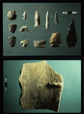
Whittlesey Culture artifacts: “South Park Village points (above) and pottery fragment (below)”
~ Cuyahoga Valley National Park
Among American writers, Mr. Short speaks of his investigations as of “greater value, due to the eminence of the antiquarian who writes them.” Hon. John D. Baldwin says, “in this Ancient America speaks of Colonel Whittlesey as one of the best authorities.” The learned Frenchman, Marquis de Nadaillac and writers generally upon such subjects quote his information and conclusions with that high and safe confidence in his learning and sound views which is the best tribute to Colonel Whittlesey, and at the same time a great help to the authors. And no one could write with any fullness on the archaeology of America without using liberally the work of Colonel Whittlesey, as will appear in any book on the subject. He was an extensive, original investigator, always observing, thoughtful and safe, and in some branches, as in Ancient Mining at Lake Superior, his work has been the substantial basis of present learning. It is noticeable that the most eminent gentlemen have best appreciated his safe and varied learning. Colonel Whittlesey was early in the geological field. Fifty years ago little was known of paleontology, and Colonel Whittlesey cared little for it, perhaps too little; but in economic geology, in his knowledge of Ohio, its surface, its strata, its iron, its coal and its limestone in his knowledge of the copper and iron of the northwest, he excelled indeed. From that date to his death he studied intelligently these sections. As Professor Lapham said he was studying Wisconsin, so did Colonel Whittlesey give himself to Ohio, its mines and its miners, its manufactures, dealings in coal and iron, its history, archaeology, its religion and its morals. Nearly all his articles contributed to magazines were to western magazines, and anyone who undertook a literary enterprise in the state of Ohio that promised value was sure to have his aid.6
In geology his services were great. The New York Herald, already cited, speaks of his help toward opening coal mines in Ohio and adds,“he was largely instrumental in discovering and causing the development of the great iron and copper regions of Lake Superior.” Twenty-six years ago he discovered a now famous range of iron ore.
“ On the Mound Builders and on the geological character and phenomena of the region of the lakes and the northwest he was quoted extensively as an authority in most of the standard geological and anthropological works of America and Europe,” truthfully says the ‘Biographical Cyclopedia.
Colonel Whittlesey was as zealous in helping to preserve new and original material for history as for science. In 1869 he pushed with energy the investigation, examination and measures which resulted in the purchase by the State of Ohio of the St. Clair papers so admirably, fully and ably edited by Mr. William Henry Smith, and in 1882 published in two large and handsome volumes by Messrs. Robert Clarke and Co. of Cincinnati.
Colonel Whittlesey was very prominent in the project which ended in the publication of the Margry papers in Paris. Their value may be gathered from the writing of Mr. Parkman (La Salle) and The Narrative and Critical History of America, Volume IV., where on page 242 is an account of their publication.7 In 1870 and 1871 an effort to enlist congress failed. The Boston fire defeated the efforts of Mr. Parkman to have them published in that city. Colonel Whittlesey originated the plan eventually adopted, by which congress voted ten thousand dollars as a subscription for five hundred copies, and, as says our history: “at last by Mr. Parkman’s assiduous labors in the east, and by those of Colonel Whittlesey, Mr. O. H. Marshall and others in the west,” the bill was passed.
The late President Garfield, an active member of our society, took a lively interest in the matter, and instigated by Colonel Whittlesey used his strong influence in its favor. Mr. Margry has felt and expressed a very warm feeling for Colonel Whittlesey for his interest and efforts, and since the colonel’s death, and in ignorance of it, has written him a characteristic letter to announce to the colonel, first of any in America, the completion of the work. A copy of the letter follows :
“PARIS, November 4, 1886.
“VERY DEAR AND HONORED SIR: It is to-day in France, St. Charles’ day, the holiday I wished when I had friends so called. I thought it suitable to send you to-day the good news to continue celebrating as of old. You will now be the first in America to whom I write it. I have just given the check to be drawn, for the last leaves of the work, of which your portrait may show a volume under your arm.8 Therefore there is no more but stitching to be done to send the book on its way.
“In telling you this I will not forget to tell you that I well remembered the part you took in that, publication as new, as glorious for the origin of your state, and for which you can congratulate yourself, in thanking you I have but one regret, that Mr. Marshall can not have the same pleasure. I hope that your health as well as that of Madame Whittlesey is satisfactory. I would be happy to hear so. For me if I am in good health it is only by the intervention of providence. However, I have lost much strength, though I do not show it. We must try to seem well.
“Receive, dear and honored sir, and for Madame, the assurance of my profound respect and attachment.
“PIERRE MARGRY.”
Colonel Whittlesey views of the lives of others were affected by his own. Devoted to extending human learning, with little thought of self interest, he was perhaps a little too impatient with others, whose lives had other ends deemed by them more practical. Yet after all, the colonel’s life was a real one, and his pursuits the best as being nearer to nature and far removed from the adventitious circumstances of what is ordinarily called polite life.
He impressed his associates as being full of learning, not from books, but nevertheless of all around — the roads the fields, the waters, the sky, men animals or plants. Charming it was to be with him in excursions; that was really life and elevated the mind and heart.
He was a profoundly religious man, never ostentatiously so, but to him religion and science were twin and inseparable companions. They were in his life and thought, and he wished to and did live to express in print his sense that the God of science was the God of religion, and that the Maker had not lost power over the thing made.
He rounded and finished his character as he finished his life, by joint and hearty affection and service to the two joint instruments of God’s revelation, for so he regarded them. Rev. Dr. Hayden testifies: “He had no patience with materialism, but in his mature strength of mind had harmonized the facts of science with the truths of religion.”

Charles Whittlesey
~ Magazine of Western History, Volume V, page 536.
Colonel Whittlesey’s life was plain, regular and simple. During the last few years he suffered much from catarrhal headache, rheumatism and kindred other troubles, and it was difficult for him to get around even with crutches. This was attributed to the exposure he had suffered for the fifteen years he had been exposed in the Lake Superior region, and his long life and preservation of a clear mind was no doubt due to his simple habits. With considerable bodily suffering, his mind was on the alert, and he seemed to have after all considerable happiness, and, to quote Dr Hayden, he could say with Byrd, “thy mind to me a kingdom is.”
Colonel Whittlesey was an original member of the American Association for the Advancement of Science, an old and valued member of the American Antiquarian society, an honorary member of the Ohio State Archaeological and Historical society, with headquarters at Columbus. He was trustee of the former State Archaeological society (making the archaeological exhibition at the Centennial), and although each of these is necessarily to some extent a rival of his pet society, he took a warm interest in the welfare of each.
He was a member of the Society of Americanites of France, and his judgment, learning and communications were much esteemed by the French members of that society. Of how many other societies he was an honorary or other member I can not tell.
C. C. Baldwin.
1 – Speech of May 9, 1862.
2 – Cincinnati Commercial, April 9, 1862.
3 – The society was organized under the auspices of the Cleveland Library Association (now Case Library). The plan occurred to the writer while vice-president of that association. At the annual meeting in 1867, the necessary changes were made in the constitution, and Colonel Whittlesey was elected to the Case Library board for the purpose of heading the historical committee and movement. The result appears in a scarce pamphlet issued in 1867 by the library association, containing, among other things, an account of the formation of the society and an address by Colonel Whittlesey, which is an interesting sketch of the successive literary and library societies of Cleveland, of which the first was in 1811.
4 – Mary E. Lyon was a daughter of James Lyon of Oswego, and sister of John E. Lyon, now of Oswego but years ago a prominent citizen of Cleveland. She m. first Colonel Theophilus Morgan,6 Theophilus,5 Theophilus,4 Theophilus,3 John,2 James Morgan.1 Colonel Morgan was an honored citizen of Oswego. Colonel Morgan and his wife Mary, had a son James Sherman, a very promising young man, killed in 1864 in a desperate cavalry charge in which he was lieutenant, in Sherman’s march to the sea. Mrs. Whittlesey survives in Cleveland.
5 – October, 19, 1886.
6 – The Hesperian, American Pioneer, the Western Literary Journal and Review of Cincinnati, the Democratic Review and Ohio Cultivator of Columbus, and later the Magazine of Western History at Cleveland, all received his hearty support.
7 – These papers were also described in an extract from a congressional speech of the late President Garfield. The extract is in Tract No. 20 of the Historical society.
8 – Alluding to a photograph of Colonel Whittlesey
then with a book under his arm.
Photos, Photos, Photos
February 10, 2014
The queue of Chequamegon History posts that need to be written grows much faster than my ability to write them. Lately, I’ve been backed up with mysteries surrounding a number of photographs. Many of these photos are from after 1860, so they are technically outside the scope of this website (though they involve people who were important in the pre-1860 era too.
Photograph posts are some of the hardest to write, so I decided to just run through all of them together with minimal commentary other than that needed to resolve the unanswered questions. I will link all the photos back to their sources where their full descriptions can be found. Here it goes, stream-of-consciousness style:

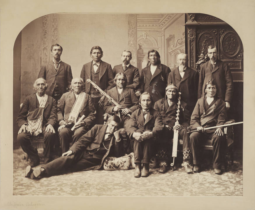
Ojibwa Delegation by C.M. Bell. Washington D.C. 1880 (NMAI Collections)
This whole topic started with a photo of a delegation of Lake Superior Ojibwe chiefs that sits on the windowsill of the Bayfield Public Library. Even though it is clearly after 1860, some of the names in the caption: Oshogay, George Warren, and Vincent Roy Jr. caught my attention. These men, looking past their prime, were all involved in the politics of the 1850s that I had been studying, so I wanted to find out more about the picture.
As I mentioned in the Oshogay post, this photo is also part of the digital collections of the Smithsonian, but the people are identified by different names. According to the Smithsonian, the picture was taken in Washington in 1880 by the photographer C.M. Bell.
I found a second version of this photo as well. If it wasn’t for one of the chiefs in front, you’d think it was the same picture:
Chippewa Delegation (Denver Public Library Digital Collections)
While my heart wanted to believe the person, probably in the early 20th century, who labelled the Bayfield photograph, my head told me the photographer probably wouldn’t have known anything about the people of Lake Superior, and therefore could only have gotten the chiefs’ names directly from them. Plus, Bell took individual photos:
Edawigijig (Edawi-giizhig “Both Sides of the Sky”), Bad River chief and signer of the Treaty of 1854 (C.M. Bell, Smithsonian Digital Collections)
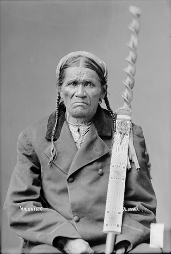
Niizhogiizhig: “Second Day,” (C.M. Bell, Smithsonian Digital Collections)
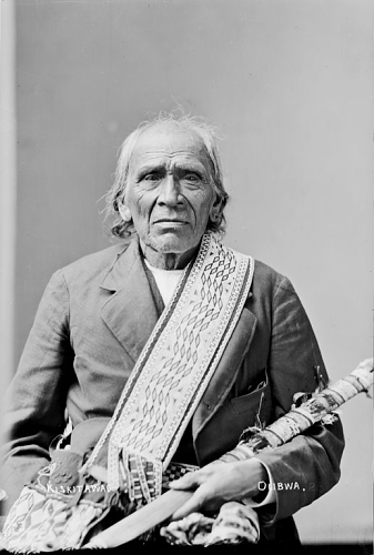
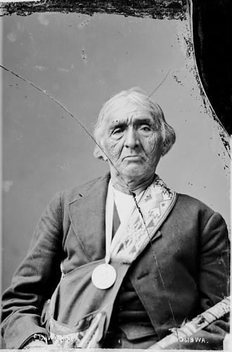
Kiskitawag (Giishkitawag: “Cut Ear”) signed multiple treaties as a warrior of the Ontonagon Band but afterwards was associated with the Bad River Band (C.M. Bell, Smithsonian Digital Collections).
By cross-referencing the individual photos with the names listed with the group photo, you can identify nine of the thirteen men. They are chiefs from Bad River, Lac Courte Oreilles, and Lac du Flambeau.
 According to this, the man identified by the library caption as Vincent Roy Jr., was in fact Ogimaagiizhig (Sky Chief). He does have a resemblance to Roy, so I’ll forgive whoever it was, even if it means having to go back and correct my Vincent Roy post:
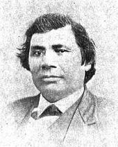
Vincent Roy Jr. From C. Verwyst’s Life and Labors of Rt. Rev. Frederic Baraga, First Bishop of Marquette, Mich: To which are Added Short Sketches of the Lives and Labors of Other Indian Missionaries of the Northwest (Digitized by Google Books)

Top: Frank Roy, Vincent Roy, E. Roussin, Old Frank D.o., Bottom: Peter Roy, Jos. Gourneau (Gurnoe), D. Geo. Morrison. The photo is labelled Chippewa Treaty in Washington 1845 by the St. Louis Hist. Lib and Douglas County Museum, but if it is in fact in Washington, it was probably the Bois Forte Treaty of 1866, where these men acted as conductors and interpreters (Digitized by Mary E. Carlson for The Sawmill Community at Roy’s Point).
So now that we know who went on the 1880 trip, it begs the question of why they went. The records I’ve found haven’t been overly clear, but it appears that it involved a bill in the senate for “severalty” of the Ojibwe reservations in Wisconsin. A precursor to the 1888 Allotment Act of Senator Henry Dawes, this legislation was proposed by Senator Thaddeus C. Pound of Wisconsin. It would divide the reservations into parcels for individual families and sell the remaining lands to the government, thereby greatly reducing the size of the reservations and opening the lands up for logging.
Pound spent a lot of time on Indian issues and while he isn’t as well known as Dawes or as Richard Henry Pratt the founder of the Carlisle Indian School, he probably should be. Pound was a friend of Pratt’s and an early advocate of boarding schools as a way to destroy Native cultures as a way to uplift Native peoples.
I’m sure that Pound’s legislation was all written solely with the welfare of the Ojibwe in mind, and it had nothing to do with the fact that he was a wealthy lumber baron from Chippewa Falls who was advocating damming the Chippewa River (and flooding Lac Courte Oreilles decades before it actually happened). All sarcasm aside, if any American Indian Studies students need a thesis topic, or if any L.C.O. band members need a new dartboard cover, I highly recommend targeting Senator Pound.
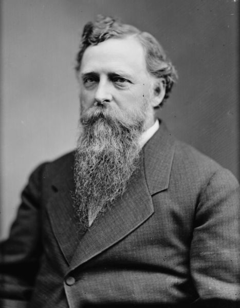
Like many self-proclaimed “Friends of the Indian” in the 1880s, Senator Thaddeus C. Pound of Wisconsin thought the government should be friendly to Indians by taking away more of their land and culture. That he stood to make a boatload of money out of it was just a bonus (Brady & Handy: Wikimedia Commons).
While we know Pound’s motivations, it doesn’t explain why the chiefs came to Washington. According to the Indian Agent at Bayfield they were brought in to support the legislation. We also know they toured Carlisle and visited the Ojibwe students there. There are a number of potential explanations, but without having the chiefs’ side of the story, I hesitate to speculate. However, it does explain the photograph.
Now, let’s look at what a couple of these men looked like two decades earlier:
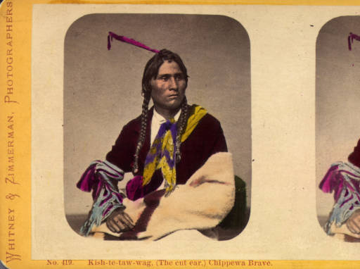
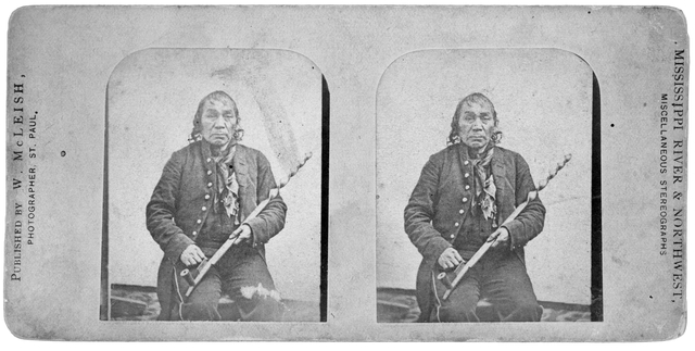
This stereocard of Giishkitawag was produced in the early 1870s, but the original photo was probably taken in the early 1860s (Denver Public Library).

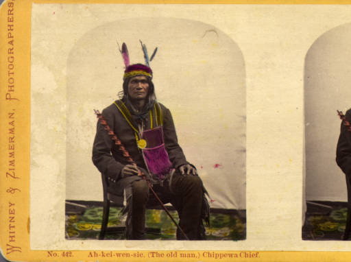
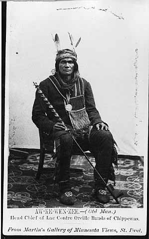
By the mid 1850s, Akiwenzii (Old Man) was the most prominent chief of the Lac Courte Oreilles Band. This stereocard was made by Whitney and Zimmerman c.1870 from an original possibly by James E. Martin in the late 1850s or early 1860s (Denver Public Library).
Giishkitawag and Akiwenzii are seem to have aged quite a bit between the early 1860s, when these photos were taken, and 1880 but they are still easily recognized. The earlier photos were taken in St. Paul by the photographers Joel E. Whitney and James E. Martin. Their galleries, especially after Whitney partnered with Charles Zimmerman, produced hundreds of these images on cards and stereoviews for an American public anxious to see real images of Indian leaders.
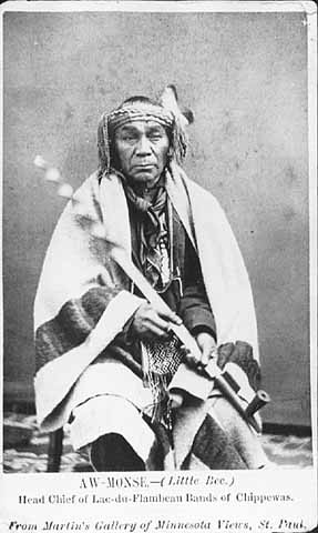
Giishkitawag and Akiwenzii were not the only Lake Superior chiefs to end up on these souvenirs. Aamoons (Little Bee), of Lac du Flambeau appears to have been a popular subject:

Aamoons (Little Bee) was a prominent chief from Lac du Flambeau (Denver Public Library).
As the images were reproduced throughout the 1870s, it appears the studios stopped caring who the photos were actually depicting:

One wonders what the greater insult to Aamoons was: reducing him to being simply “Chippewa Brave” as Whitney and Zimmerman did here, or completely misidentifying him as Na-gun-ub (Naaganab) as a later stereo reproduction as W. M. McLeish does here:
Chief identified as Na-gun-ub (Minnesota Historical Society)
Aamoons and Naaganab don’t even look alike…

Naaganab (Minnesota Historical Society)
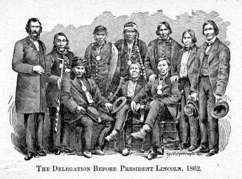
…but the Lac du Flambeau and Fond du Lac chiefs were probably photographed in St. Paul around the time they were both part of a delegation to President Lincoln in 1862.

Chippewa Delegation 1862 by Matthew Brady? (Minnesota Historical Society)
Naaganab (seated middle) and Aamoons (back row, second from left) are pretty easy to spot, and if you look closely, you’ll see Giishkitawag, Akiwenzii, and a younger Edawi-giizhig (4th, 5th, and 6th from left, back row) were there too. I can’t find individual photos of the other chiefs, but there is a place we can find their names.
(From Early Life Among the Indians by Benjamin Armstrong)
Benjamin Armstrong, who interpreted for the delegation, included a version of the image in his memoir Early Life Among the Indians. He identifies the men who went with him as:
Ah-moose (Little Bee) from Lac Flambeau Reservation, Kish-ke-taw-ug (Cut Ear) from Bad River Reservation, Ba-quas (He Sews) from Lac Courte O’Rielles Reservation, Ah-do-ga-zik (Last Day) from Bad River Reservation, O-be-quot (Firm) from Fond du Lac Reservation, Sing-quak-onse (Little Pine) from La Pointe Reservation, Ja-ge-gwa-yo (Can’t Tell) from La Pointe Reservation, Na-gon-ab (He Sits Ahead) from Fond du Lac Reservation, and O-ma-shin-a-way (Messenger) from Bad River Reservation.
It appears that Armstrong listed the men according to their order in the photograph. He identifies Akiwenzii as “Ba-quas (He Sews),” which until I find otherwise, I’m going to assume the chief had two names (a common occurrence) since the village is the same. Aamoons, Giishkitawag, Edawi-giizhig and Naaganab are all in the photograph in the places corresponding to the order in Armstrong’s list. That means we can identify the other men in the photo.
I don’t know anything about O-be-quot from Fond du Lac (who appears to have been moved in the engraving) or S[h]ing-guak-onse from Red Cliff (who is cut out of the photo entirely) other than the fact that the latter shares a name with a famous 19th-century Sault Ste. Marie chief. Travis Armstrong’s outstanding website, chiefbuffalo.com, has more information on these chiefs and the mission of the delegation.
Seated to the right of Naaganab, in front of Edawi-giizhig is Omizhinawe, the brother of and speaker for Blackbird of Bad River. Finally, the broad-shouldered chief on the bottom left is “Ja-ge-gwa-yo (Can’t Tell)” from Red Cliff. This is Jajigwyong, the son of Chief Buffalo, who signed the treaties as a chief in his own right. Jayjigwyong, sometimes called Little Chief Buffalo, was known for being an early convert to Catholicism and for encouraging his followers to dress in European style. Indeed, we see him and the rest of the chiefs dressed in buttoned coats and bow-ties and wearing their Lincoln medals.
Wait a minute… button coats?… bow-ties?… medals?…. a chief identified as Buffalo…That reminds me of…
This image is generally identified as Chief Buffalo (Wikimedia Commons)

Anyway, with that mystery solved, we can move on to the next one. It concerns a photograph that is well-known to any student of Chequamegon-area history in the mid 19th century (or any Chequamegon History reader who looks at the banners on the side of this page).Noooooo!!!!!!! I’ve been trying to identify the person in The above “Chief Buffalo” photo for years, and the answer was in Armstrong all along! Now I need to revise this post among others. I had already begun to suspect it was Jayjigwyong rather than his father, but my evidence was circumstantial. This leaves me without a doubt. This picture of the younger Chief Buffalo, not his more-famous father.
The photo showing an annuity payment, must have been widely distributed in its day, because it has made it’s way into various formats in archives and historical societies around the world. It has also been reproduced in several secondary works including Ronald Satz’ Chippewa Treaty Rights, Patty Loew’s Indian Nations of Wisconsin, Hamilton Ross’ La Pointe: Village Outpost on Madeline Island, and in numerous other pamphlets, videos, and displays in the Chequamegon Region. However, few seem to agree on the basic facts:
When was it taken?
Where was it taken?
Who was the photographer?
Who are the people in the photograph?
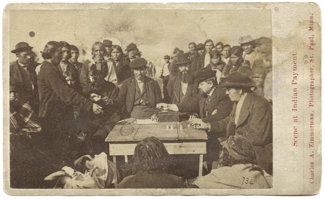
We’ll start with a cropped version that seems to be the most popular in reproductions:
According to Hamilton Ross and the Wisconsin Historical Society: “Annuity Payment at La Pointe: Indians receiving payment. Seated on the right is John W. Bell. Others are, left to right, Asaph Whittlesey, Agent Henry C. Gilbert, and William S. Warren (son of Truman Warren).” 1870. Photographer Charles Zimmerman (more info).
In the next one, we see a wider version of the image turned into a souvenir card much like the ones of the chiefs further up the post:
According to the Minnesota Historical Society “Scene at Indian payment, Wisconsin; man in black hat, lower right, is identified as Richard Bardon, Superior, Wisconsin, then acting Indian school teacher and farmer” c.1871 by Charles Zimmerman (more info).
In this version, we can see more foreground and the backs of the two men sitting in front.

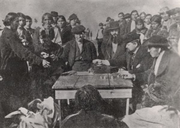
According to the Library of Congress: “Cherokee payments(?). Several men seated around table counting coins; large group of Native Americans stand in background.” Published 1870-1900 (more info).
The image also exists in engraved forms, both slightly modified…

According to Benjamin Armstrong: “Annuity papment [sic] at La Pointe 1852” (From Armstrong’s Early Life Among the Indians)
…and greatly-modified.
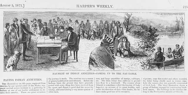
Harper’s Weekly August 5, 1871: “Payment of Indian Annuities–Coming up to the Pay Table.” (more info)
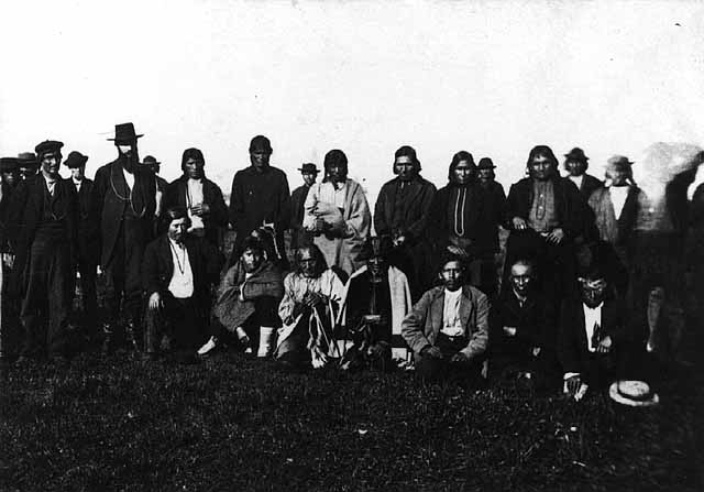
It should also be mentioned that another image exists that was clearly taken on the same day. We see many of the same faces in the crowd:
Scene at Indian payment, probably at Odanah, Wisconsin. c.1865 by Charles Zimmerman (more info)
We have a lot of conflicting information here. If we exclude the Library of Congress Cherokee reference, we can be pretty sure that this is an annuity payment at La Pointe or Odanah, which means it was to the Lake Superior Ojibwe. However, we have dates ranging from as early as 1852 up to 1900. These payments took place, interrupted from 1850-1852 by the Sandy Lake Removal, from 1837 to 1874.
Although he would have attended a number of these payments, Benjamin Armstrong’s date of 1852, is too early. A number of secondary sources have connected this photo to dates in the early 1850s, but outside of Armstrong, there is no evidence to support it.
Charles Zimmerman, who is credited as the photographer when someone is credited, became active in St. Paul in the late 1860s, which would point to the 1870-71 dates as more likely. However, if you scroll up the page and look at Giishkitaawag, Akiwenzii, and Aamoons again, you’ll see that these photos, (taken in the early 1860s) are credited to “Whitney & Zimmerman,” even though they predate Zimmerman’s career.
What happened was that Zimmerman partnered with Joel Whitney around 1870, eventually taking over the business, and inherited all Whitney’s negatives (and apparently those of James Martin as well). There must have been an increase in demand for images of Indian peoples in the 1870s, because Zimmerman re-released many of the earlier Whitney images.
So, we’re left with a question. Did Zimmerman take the photograph of the annuity payment around 1870, or did he simply reproduce a Whitney negative from a decade earlier?
I had a hard time finding any primary information that would point to an answer. However, the Summer 1990 edition of the Minnesota History magazine includes an article by Bonnie G. Wilson called Working the Light: Nineteenth Century Professional Photographers in Minnesota. In this article, we find the following:
“…Zimmerman was not a stay-at-home artist. He took some of his era’s finest landscape photos of Minnesota, specializing in stereographs of the Twin Cities area, but also traveling to Odanah, Wisconsin for an Indian annuity payment…”
In the footnotes, Wilson writes:
“The MHS has ten views in the Odanah series, which were used as a basis for engravings in Harper’s Weekly, Aug. 5, 1871. See also Winona Republican, Oct. 12, 1869 p.3;”
Not having access to the Winona Republican, I tried to see how many of the “Odanah series” I could track down. Zimmerman must have sold a lot of stereocards, because this task was surprisingly easy. Not all are labelled as being in Odanah, but the backgrounds are similar enough to suggest they were all taken in the same place. Click on them to view enlarged versions at various digital archives.
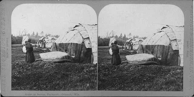
Scene at Indian Payment, Odanah Wisconsin (Minnesota Historical Society)


Chippewa Wedding (British Museum)

Domestic Life–Chippewa Indians (British Museum)

Chippewa Wedding (British Museum)

Finally…

Scene at Indian Payment–Odanah, Wis. (Wikimedia Images)
So, if Zimmerman took the “Odanah series” in 1869, and the pay table image is part of it, then this is a picture of the 1869 payment. To be absolutely certain, we should try to identify the men in the image.
This task is easier than ever because the New York Public Library has uploaded a high-resolution scan of the Whitney & Zimmerman stereocard version to Wikimedia Commons. For the first time, we can really get a close look at the men and women in this photo.
They say a picture tells a thousand words. I’m thinking I could write ten-thousand and still not say as much as the faces in this picture.


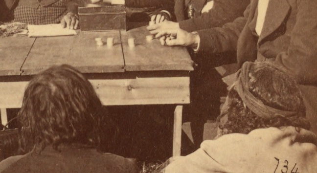
To try to date the photo, I decided to concentrate the six most conspicuous men in the photo:
1) The chief in the fur cap whose face in the shadows.
2) The gray-haired man standing behind him.
3) The man sitting behind the table who is handing over a payment.
4) The man with the long beard, cigar, and top hat.
5) The man with the goatee looking down at the money sitting to the left of the top-hat guy (to the right in our view)
6) The man with glasses sitting at the table nearest the photographer
According to Hamilton Ross, #3 is Asaph Whittlesey, #4 is Agent Henry Gilbert, #5 is William S. Warren (son of Truman), and #6 is John W. Bell. While all four of those men could have been found at annuity payments as various points between 1850 and 1870, this appears to be a total guess by Ross. Three of the four men appear to be of at least partial Native descent and only one (Warren) of those identified by Ross was Ojibwe. Chronologically, it doesn’t add up either. Those four wouldn’t have been at the same table at the same time. Additionally, we can cross-reference two of them with other photos.

Asaph Whittlesey was an interesting looking dude, but he’s not in the Zimmerman photo (Wisconsin Historical Society).

Henry C. Gilbert was the Indian Agent during the Treaty of 1854 and oversaw the 1855 annuity payment, but he was dead by the time the “Zimmerman” photo was taken (Branch County Photographs)
Whittlesey and Gilbert are not in the photograph.
The man who I label as #5 is identified by Ross as William S. Warren. This seems like a reasonable guess, though considering the others, I don’t know that it’s based on any evidence. Warren, who shares a first name with his famous uncle William Whipple Warren, worked as a missionary in this area.
The man I label #6 is called John W. Bell by Ross and Richard Bardon by the Minnesota Historical Society. I highly doubt either of these. I haven’t found photos of either to confirm, but the Ireland-born Bardon and the Montreal-born Bell were both white men. Mr. 6 appears to be Native. I did briefly consider Bell as a suspect for #4, though.
Neither Ross nor the Minnesota Historical Society speculated on #1 or #2.
At this point, I cannot positively identify Mssrs. 1, 2, 3, 5, or 6. I have suspicions about each, but I am not skilled at matching faces, so these are wild guesses at this point:
#1 is too covered in shadows for a clear identification. However, the fact that he is wearing the traditional fur headwrap of an Ojibwe civil chief, along with a warrior’s feather, indicates that he is one of the traditional chiefs, probably from Bad River but possibly from Lac Courte Oreilles or Lac du Flambeau. I can’t see his face well enough to say whether or not he’s in one of the delegation photos from the top of the post.
#2 could be Edawi-giizhig (see above), but I can’t be certain.
#3 is also tricky. When I started to examine this photo, one of the faces I was looking for was that of Joseph Gurnoe of Red Cliff. You can see him in a picture toward the top of the post with the Roy brothers. Gurnoe was very active with the Indian Agency in Bayfield as a clerk, interpreter, and in other positions. Comparing the two photos I can’t say whether or not that’s him. Leave a comment if you think you know.
#5 could be a number of different people.
#6 I don’t have a solid guess on either. His apparent age, and the fact that the Minnesota Historical Society’s guess was a government farmer and schoolteacher, makes me wonder about Henry Blatchford. Blatchford took over the Odanah Mission and farm from Leonard Wheeler in the 1860s. This was after spending decades as Rev. Sherman Hall’s interpreter, and as a teacher and missionary in La Pointe and Odanah area. When this photo was taken, Blatchford had nearly four decades of experience as an interpreter for the Government. I don’t have any proof that it’s him, but he is someone who is easy to imagine having a place at the pay table.
Finally, I’ll backtrack to #4, whose clearly identifiable gray-streaked beard allows us to firmly date the photo. The man is Col. John H. Knight, who came to Bayfield as Indian Agent in 1869.
Col. John H. Knight (Wisconsin Historical Society)
Knight oversaw a couple of annuity payments, but considering the other evidence, I’m confident that the popular image that decorates the sides of the Chequamegon History site was indeed taken at Odanah by Charles Zimmerman at the 1869 annuity payment.
Do you agree? Do you disagree? Have you spotted anything in any of these photos that begs for more investigation? Leave a comment.
As for myself, it’s a relief to finally get all these photo mysteries out of my post backlog. The 1870 date on the Zimmerman photo reminds me that I’m spending too much time in the later 19th century. After all, the subtitle of this website says it’s history before 1860. I think it might be time to go back for a while to the days of the old North West Company or maybe even to Pontiac. Stay tuned, and thanks for reading,
Chief Buffalo Picture Search: The Armstrong Engraving
October 3, 2013
This post is one of several that seek to determine how many images exist of Great Buffalo, the famous La Pointe Ojibwe chief who died in 1855. To learn why this is necessary, please read this post introducing the Great Chief Buffalo Picture Search.
In 1892, thirty-seven years after the death of the La Pointe Chief Buffalo, a curious book appeared on the market. It was printed by A.W, Bowron of Ashland, Wisconsin, just south of Madeline Island at the end of Chequamegon Bay. It was titled Early Life Among the Indians: Reminiscences From the Life of Benj. G. Armstrong. More than any other book, this work has informed the public about the life of Buffalo, and it contains the only complete account of his famous 1852 journey to Washington D.C.
Benjamin Armstrong was born in Alabama. As a young man, he travelled throughout the South and up the Mississippi River eventually making it to Wisconsin. He learned Ojibwe, settled on Madeline Island, and married one of Buffalo’s nieces. Over time, he became Buffalo’s personal interpreter and accompanied him to Washington. His work translating the 1854 Treaty of La Pointe, which established reservations in Wisconsin on largely favorable terms to the Ojibwe, led Buffalo to refer to him as an adopted son. The chief even inserted a provision for a section of land for Armstrong within the ceded territory. The land Armstrong chose was at the site where downtown Duluth would rise.
Over the next several decades, Armstrong battled poverty, temporary blindness, and alcohol. He was duped into trading away his claim on Duluth and lost his bid to regain it in the U.S. Supreme Court. Had he hung on to the land, it would have made him very wealthy, but instead, he remained poor in the Chequamegon region. As he neared the end of his life, he decided to team with Thomas P. Wentworth of Ashland to record his memoirs. The work was completed in 1891 and went to press the following year.
Early Life Among the Indians is a complex work. Much of it contains rich details that could only have come from the true experiences of an insider. Other parts appear to be wholly fabricated. Armstrong’s tone is more that of a northwoods storyteller than it is of a academic historian. Faced with this dilemma, modern scholars of Ojibwe history have either fully embraced Armstrong or have completely rejected him. For the purposes of this study, we cannot do either.
Some of the images in Armstrong’s memior seem to have been created especially for the work and were not derived from earlier photographs (Marr and Richards Co.).
In the first two chapters, Armstrong describes the trip to Washington. He mentions himself, Buffalo, and the young orator Oshogay, making the trip along with four other Ojibwe men. From other sources, we know that a young mixed-blood from La Pointe, Vincent Roy Jr., was also part of the delegation. Within these two chapters, there are two images. Each may contain a representation of Buffalo.
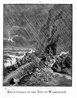
All of the images in the book are from engravings produced by the Marr and Richards Engraving Company of Milwaukee. Born and trained in Germany, master engraver John Marr had started the company with the American-born George Richards in 1888. Their highly-precise maps, and illustrations appeared throughout the upper Midwest during this time period. For Early Life Among the Indians, it appears that Marr and Richards produced two types of engravings. One type was derived from original photographs, and the others were original designs to illustrate incidents from Armstrong’s stories. Of the latter type, a plate between pages 32 and 33 shows an image of five Indians huddled around a fire during a fierce thunderstorm. A bearded figure in a raincoat, presumably Armstrong, stands in the background.
This image, called Encountered on the Tpip [sic] to Washington., illustrates a part of Armstrong’s story where the delegation had to pull their canoe out of the water during a storm on the south shore of Lake Superior on the first leg of the journey. Of the five Ojibwe men shown, the one with the most feathers, nearest the viewer with his back and profile visible is the most prominent. However, all five are simple renderings that play into Indian stereotypes of the day and do not appear to be based on any real images. So, while the illustrators may have intended one to show Buffalo, this image was produced long after his death and does nothing to suggest what he would have looked like.
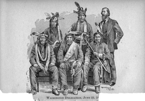
Washington Delegation, June 22, 1852: Chief Buffalo led this famous Ojibwe delegation to Washington, so it is assumed he is one of the men in this engraving, but which one? The original photograph has not been located (Marr and Richards Co.).
The image labelled Washington Delegation, June 22,1852, between pages 16 and 17, is much more intriguing. It shows three seated men in front of three standing men. The man standing on the right appears to be Armstrong, but the rest of them are not identified. There has been a lot of speculation whether or not this image shows Chief Buffalo. The man seated in the middle with the large white sash across his chest was featured on on poster of Buffalo released by the Minnesota Historical Society in the 1980s. He does appear to be the oldest and most prominent of the group. However, the man holding a pipe sitting to his left (bottom right in the picture)was used as the model for the large outdoor mural of Buffalo on the corner of Highways 2 and 13 in Ashland.
Besides the title and the engraver’s mark, there is no other information to identify the origin of this image. It almost certainly came from a photograph. Two similar engravings, found elsewhere in the book can be traced to specific photos. One Armstrong identifies as being the 1862 Ojibwe delegation to President Lincoln. In the engraving, seven chiefs stand behind three who sit. Again, the men are not identified, but Armstrong lists the names of the chiefs who accompanied him on pages 66 and 67. The Fond du Lac chief, Naaganab (Sits in Front) is identifiable from other photographs. As his name would suggest, he is seated in front in the center.


The photograph this engraving was made from was taken by the famous Civil War photographer Matthew Brady, and it can be found in the collections of the Minnesota Historical Society. From the postures and facial expressions of the men, it is clear the engraving was made from this photo. However, the two images are not exact duplicates. The man standing third from the left in the photo appears to have been moved to the far right in the engraving, and to the right of him, we see another man who is not in the photo. Because the photograph from MHS cuts off immediately to the right of the man who is third from the right in the engraving, it is impossible to know whether or not anyone stood there when the photo was taken.
The other engraving based on a photograph appears between pages 134 and 135. Armstrong identifies it as Annuity papement [sic] at La Pointe, 1852. The photograph it comes from, by Charles Zimmerman, is well known to scholars of this time period, and it appears in many secondary works. One copy is held by the Wisconsin Historical Society. It shows four government officials from La Pointe seated at a table surrounded by Ojibwe men and women waiting to receive their treaty payments. Sources vary on the date. The Historical Society identifies it as 1870 and describes it as “Indians receiving payment. Seated on the right is John W. Bell. Others are, left to right, Asaph Whittlesey, Agent Henry C. Gilbert, and William S. Warren (son of Truman Warren).”

While the engraving of the 1852 Delegation is clearly also from a photograph, the original has not been located. If it exists, and contains any more identifying information, it represents possibly the best opportunity to see what Buffalo looked like. We need to find the photo!
The Verdict
Inconclusive: One of these men could be Buffalo from La Pointe, but more information is needed.
Sources:
Armstrong, Benj G., and Thomas P. Wentworth. Early Life among the Indians: Reminiscences from the Life of Benj. G. Armstrong : Treaties of 1835, 1837, 1842 and 1854 : Habits and Customs of the Red Men of the Forest : Incidents, Biographical Sketches, Battles, &c. Ashland, WI: Press of A.W. Bowron, 1892. Print.
Ashland Chamber of Commerce. “Ashland Mural Walk.” Ashland Wisconsin. N.p., n.d. Web. 28 June 2012. <http://www.visitashland.com/>.
Brady, Matthew. Ojibwe Men (Possibly at 1857 or 1862 Treaty Signing at Washington D.C.). c.1862. Photograph. Minnesota Historical Society, Washington. MHS Visual Resource Database. Minnesota Historical Society, 2012. Web. 28 June2012. <http://collections.mnhs.org/visualresources/>.
Loew, Patty. Indian Nations of Wisconsin: Histories of Endurance and Renewal. Madison: Wisconsin Historical Society, 2001. Print.
Merrill, Peter C. German Immigrant Artists in America: A Biographical Dictionary. Lanham, MD: Scarecrow, 1997. Print.
Morse, Richard F. “The Chippewas of Lake Superior.” Collections of the State Historical Society of Wisconsin. Ed. Lyman C. Draper. Vol. 3. Madison: State Historical Society of Wisconsin, 1857. 338-69. Print.
Satz, Ronald N. Chippewa Treaty Rights: The Reserved Rights of Wisconsin’s
Chippewa Indians in Historical Perspective. Madison, WI: Wisconsin Academy of
Sciences, Arts and Letters, 1991. Print.
Schenck, Theresa M. William W. Warren: The Life, Letters, and times of an Ojibwe Leader. Lincoln: University of Nebraska, 2007. Print.
Warren, William W., and Theresa M. Schenck. History of the Ojibway People. St. Paul: Minnesota Historical Society, 2009. Print.
Zimmerman, Charles A. Annuity Payment at La Pointe. c.1852-1870. Photograph. Wisconsin Historical Society, La Pointe, WI. Wisconsin Historical Images. Wisconsin Historical Society, 1996-2012. Web. 28 June 2012. <http://http://www.wisconsinhistory.org/whi>.
…a donation of twenty-four sections of land covering the graves of our fathers, our sugar orchards, and our rice lakes and rivers…
March 29, 2013

Symbolic Petition of Chippewa Chiefs: Original birch bark petition of Oshkaabewis copied by Seth Eastman and printed in “Historical and statistical information respecting the history, condition, and prospects of the Indian tribes of the United States” by Henry Rowe Schoolcraft (1851). Digitized by University of Wisconsin Libraries Wisconsin Electronic Reader project (1998).
For the first post on Chequamegon History, I thought I’d share my research into an image that has been circulating around the area for several years now. The image shows seven Ojibwe chiefs by their doodemag (clan symbols), connected by heart and mind to Lake Superior and to some smaller lakes. The clans shown are the Crane, Marten, Bear, Merman, and Bullhead.
All the interpretations I’ve heard agree that this image is a copy of a birch bark pictograph, and that it represents a unity among the several chiefs and their clans against Government efforts to remove the Lake Superior bands to Minnesota.
While there is this agreement on the why question of this petition’s creation, the who and when have been a source of confusion. Much of this confusion stems from efforts to connect this image to the famous La Pointe chief, Buffalo (Bizhiki/Gichi-weshkii).
In 2007, the Great Lakes Indian Fish and Wildlife Commission (GLIFWC) released the short documentary Mikwendaagoziwag: They Are Remembered. While otherwise a very good overview of the Lake Superior Ojibwe in this era, it incorrectly uses this image to describe Buffalo going to Washington D.C. in 1849. Buffalo is famous for a trip to Washington in 1852, but he was not part of the 1849 group.
At the time the GLIFWC film was released, the Wisconsin Historical Society website referred to this pictograph as, “Chief Buffaloʼs Petition to the President,” and identified the crane as Buffalo. Citing oral history from Lac Courte Oreilles, the Society dated the petition after the botched 1850-51 removal to Sandy Lake, Minnesota that resulted in hundreds of Ojibwe deaths from disease and starvation due to negligence, greed, and institutional racism on the part of government officials. The Historical Society has since revised its description to re-date the pictograph at 1848-49, but it still incorrectly lists Buffalo, a member of the Loon Clan, as being depicted by the crane. The Sandy Lake Tragedy, has deservedly gained coverage by historians in recent years, but the pictographic petition came earlier and was not part of it.
If the Historical Society had contacted Chief Buffaloʼs descendants in Red Cliff, they would have known that Buffalo was from the Loon Clan. The relationship between the Loons and the Cranes, as far as which clan can claim the hereditary chieftainship of the La Pointe Band, is very interesting and covered extensively in Warrenʼs History of the Ojibwe People. It would make a good subject for a future post.
After looking into the history of this image, I can confidently say that Buffalo is not one of the chiefs represented. It was created before Sandy Lake and Buffalo’s journey, but it is related to those events. Here is the story:
In late 1848, a group of Ojibwe chiefs went to Washington. They wanted to meet directly with President James K. Polk to ask for a permanent reservations in Wisconsin and Michigan. At that time the Ojibwe did not hold title to any part of the newly-created state of Wisconsin or Upper Michigan, having ceded these lands in the treaties in 1837 and 1842. In signing the treaties, they had received guarantees that they could stay in their traditional villages and hunt, fish, and gather throughout the ceded territory. However, by 1848, rumors were flying of removal of all Ojibwe to unceded lands on the Mississippi River in Minnesota Territory. These chiefs were trying to stop that from happening.
John Baptist Martell, a mix-blood, acted as their guide and interpreter. The government officials and Indian agents in the west were the ones actively promoting removal, so they did not grant permission (or travel money) for the trip. The chiefs had to pay their way as they went by putting themselves on display and dancing as they went from town to town.
Martell was accused by government officials of acting out of self interest, but the written petition presented to congress asked for, “a donation of twenty-four sections of land covering the graves of our fathers, our sugar orchards, and our rice lakes and rivers, at seven different places now occupied by us at villages…” The chiefs claimed to be acting on behalf of the chiefs of all the Lake Superior bands, and there is reason to believe them given that their request is precisely what Chief Buffalo and other leaders continued to ask for up until the Treaty of 1854.


This written petition accompanied the pictographic petitions. It clearly states the goal of the the chiefs was to secure permanent reservations around the traditional villages east of the Mississippi.
The visiting Ojibwes made a big impression on the nationʼs capital and positive accounts of the chiefs, their families, and their interpreter appeared in the magazines of the day. Congress granted them $6000 for their expenses, which according to their critics was a scheme by Martell. However, it is likely they were vilified by government officials for working outside the colonial structure and for trying to stop the removal rather than for any ill-intentions of the part of their interpreter. A full scholarly study of the 1848-49 trip remains to be done, however.
Amid articles on the end of the slave trade, the California Gold Rush, and the benefits of the “passing away of the Celt” during the Great Irish Famine, two articles appeared in Littell’s Living Age magazine about the 1849 delegation. The first is tragic, and the second is comical.
Along with written letters and petitions supporting the Ojibwe cause, the chiefs carried not only the one, but several birchbark pictographs. The pictographs show the clan animals of several chiefs and leading men from several small villages from the mouth of the Ontonagon River to Lac Vieux Desert in Upper Michigan and smaller satellite communities in Wisconsin. After seeing these petitions, the artist Seth Eastman copied them on paper and gave them to Henry Schoolcraft who printed and explained them alongside his criticism of the trip. They appear in his 1851 Historical and statistical information respecting the history, condition, and prospects of the Indian tribes of the United States.
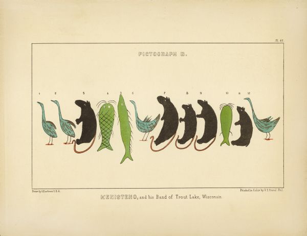
Kenisteno, and his Band of Trout Lake, Wisconsin
Okundekund, and his Band of Ontonagon, Michigan (Upper) Kakake-ogwunaosh, and his Band of the head of Wisconsin River (Lower)
According to Schoolcraft, the crane in the most famous pictograph is Oshkaabewis, a Crane-clan chief from Lac Vieux Desert, and the leader of the 1848-49 expedition. In the Treaty of 1854, he is listed as a first chief from Lac du Flambeau in nearby Wisconsin. It makes sense that someone named Oshkaabewis would lead a delegation since the word oshkaabewis is used to describe someone who carries messages and pipes for a civil chief.
Kaizheosh [Gezhiiyaash], and his band from Lake Vieu Desert, Michigan and Wisconsin (University of Nebraska Libraries)
Long Story Short…
This is not Chief Buffalo or anyone from the La Pointe Band, and it was created before the Sandy Lake Tragedy. However it is totally appropriate to use the image in connection with those topics because it was all part of the efforts of the Lake Superior Ojibwe to resist removal in the late 1840s and early 1850s. However, when you do, please remember to credit the Lac Vieux Desert/Ontonagon chiefs who created these remarkable documents.
