Martin Beaser
August 9, 2016
By Amorin Mello
Magazine of Western History Illustrated
November 1888
as republished in
Magazine of Western History: Volume IX, No.1, pages 24-27.
Martin Beaser.

Portrait of Martin Beaser on page 24.
On the fifth day of July 1854, Asaph Whittlesey and George Kilborn left La Pointe, in a row-boat, with the design of finding a “town site” on some available point near the “head of the bay.” At five o’clock P.M. of the same day they landed at the westerly limit of the present town site of Ashland. As Mr. Whittlesey stepped ashore, Mr. Kilborn exclaimed, “Here is the place for a big city!” and handing his companion an axe, he added, “I want you to have the honor of cutting the first tree in a way of a settlement upon the town site.” And the tree thus felled formed one of the foundation logs in the first building in the place. Such is the statement which has found its way into print as to the beginning of Ashland. But the same account adds: “Many new-comers arrived during the first few years after the settlement; among them Martin Beaser, who located permanently in Ashland in 1856, and was one of its founders.”1 How this was will soon be explained.
The father of the subject of this sketch, John Baptiste Beaser, was a native of Switzerland, educated as a priest, but never took orders. He came to America, reaching Philadelphia about the year 1812, where he married Margaret McLeod. They then moved to Buffalo, in one of the suburbs of which, called Williamsville, their son Martin was born, on the twenty-seventh of October, 1822. The boy received his early education in the common schools of the place, when, at the age of fourteen, he went on a whaling voyage, sailing from New Bedford, Massachusetts. His voyage lasted four years; his second voyage, three years; the last of which was made in the whaleship Rosseau, which is still afloat, the oldest of its class in America.
The young man went out as boat-steerer on his second voyage, returning as third mate. During his leisure time on shipboard and the interval between the two voyages, he spent in studying the science of navigation, which he successfully mastered. On his return from his fourth years’ cruise in the Pacific and Indian oceans, he was offered the position of second mate on a new ship then nearing completion and which would be ready to sail in about sixty days. He accepted the offer. They would notify him when the ship was ready, and he would in the meantime visit his mother, then a widow, residing in Buffalo. Accordingly, after an absence of seven years, he returned to his native city, spending the time in renewing old acquaintances and relating the varied experience of a whaler’s life. He had rare conversational powers, holding his listeners spell-bound at the recital of some thrilling adventure. A journal kept by him during his voyages and now in the possession of his family, abounds in hair-breadth escapes from savages on the shores of some of the South sea islands and the perils of whale-fishing, of which he had many narrow escapes. The time passed quickly, and he anxiously awaited the summons to join his ship. Leaving the city for a day the expected letter came, but was carefully concealed by his mother until after the ship had sailed, thus entirely changing the future of his life.
“… Martin, a sailor just from the whaling grounds of the Northwest Coast …”
Disappointed in his aspirations to command a ship in the near future, as he had reasons to hope from the rapid promotions he had already received – from a boy before the mast to mate of a ship in two voyages – and yielding to his mother’s wish not to leave home again, he engaged in sailing on Lake Erie from Buffalo to Detroit until 1847, when he went in the interest of a company in the latter city to Lake Superior for the purpose of exploring the copper ranges in the northern peninsula of Michigan. He coasted from Sault Ste. Marie to Ontonagon in a bateau. Remaining in the employ of the company about a year, he then engaged in a general forwarding and commission business for himself.
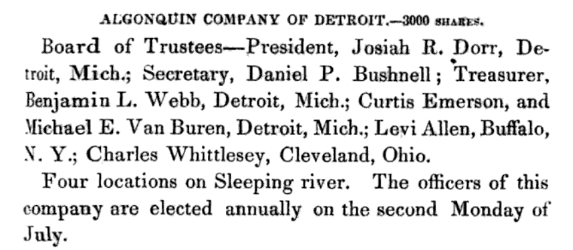
“Algonquin Company of Detroit.”
~ Reports of Wm. A. Burt and Bela Hubbard, by T. W. Bristol, 1846, page 97.
~ A History of the Northern Peninsula of Michigan and Its People: Volume 1, by Alvah Littlefield Sawyer, 1911, page 222.
Mr. Beaser was largely identified with the early mining interests of Ontonagon county, being instrumental in opening up and developing some of the best mines in that district.
In 1848 he was married in Cattaraugus county, New York, in the town of Perrysburgh, to Laura Antionette Bebee. The husband and wife the next spring went west, going to Ontonagon by way of Detroit. The trip from buffalo lasted from the first day of May to the sixth of June, they being detained at the “Soo” two weeks on account of the changing of the schooner Napoleon into a propeller, in which vessel, after a voyage of six days, they reached Ontonagon.
Here Mr. Beaser resided for seven years in the same business of forwarding and commission, furnishing frequently powder and candles to the miners by the ton. He was a portion of the this time associated with Thomas B. Hanna, formerly of Ohio. They then sold out their interest – Mr. Beaser going in company with Augustus Coburn and Edward Sayles to Superior, at the head of the lake, taking a small boat with them and Indian guides. Thus equipped they explored the region of Duluth, going up the Brule and St. Louis rivers. They then returned to La Pointe, going up Chaquamegon bay; and having their attention called to the site of what is now Ashland, on account of what seemed to be its favorable geographical position. As there had been some talk of the feasibility of connecting the Mississippi river and Lake Superior by a ship canal, it was suggested to them that this point would be a good one for its eastern terminus. Another circumstance which struck them was the contiguity of the Penokee iron range. This was in 1853. The company then returned to Ontonagon.
Closing up his business at the latter place, Mr. Beaser decided to return to the bay of Chaquamegon to look up and locate the town site on its southern shore. In the summer of 1854, on arriving there, he found Mr. Whittlesey and Mr. Kilborn on the ground. He then made arrangement with them by which he (Mr. Beaser) was to enter the land, which he did at Superior, where the land office was then located for that section. The contract between the three was, that Mr. Whittlesey and Mr. Kilborn were to receive each an eighth interest in the land, while the residue was to go to Mr. Beaser. The patent for the land was issued to Schuyler Goff, as county Judge of La Pointe county, Wisconsin, who was the trustee for the three men, under the law then governing the location of town sites.
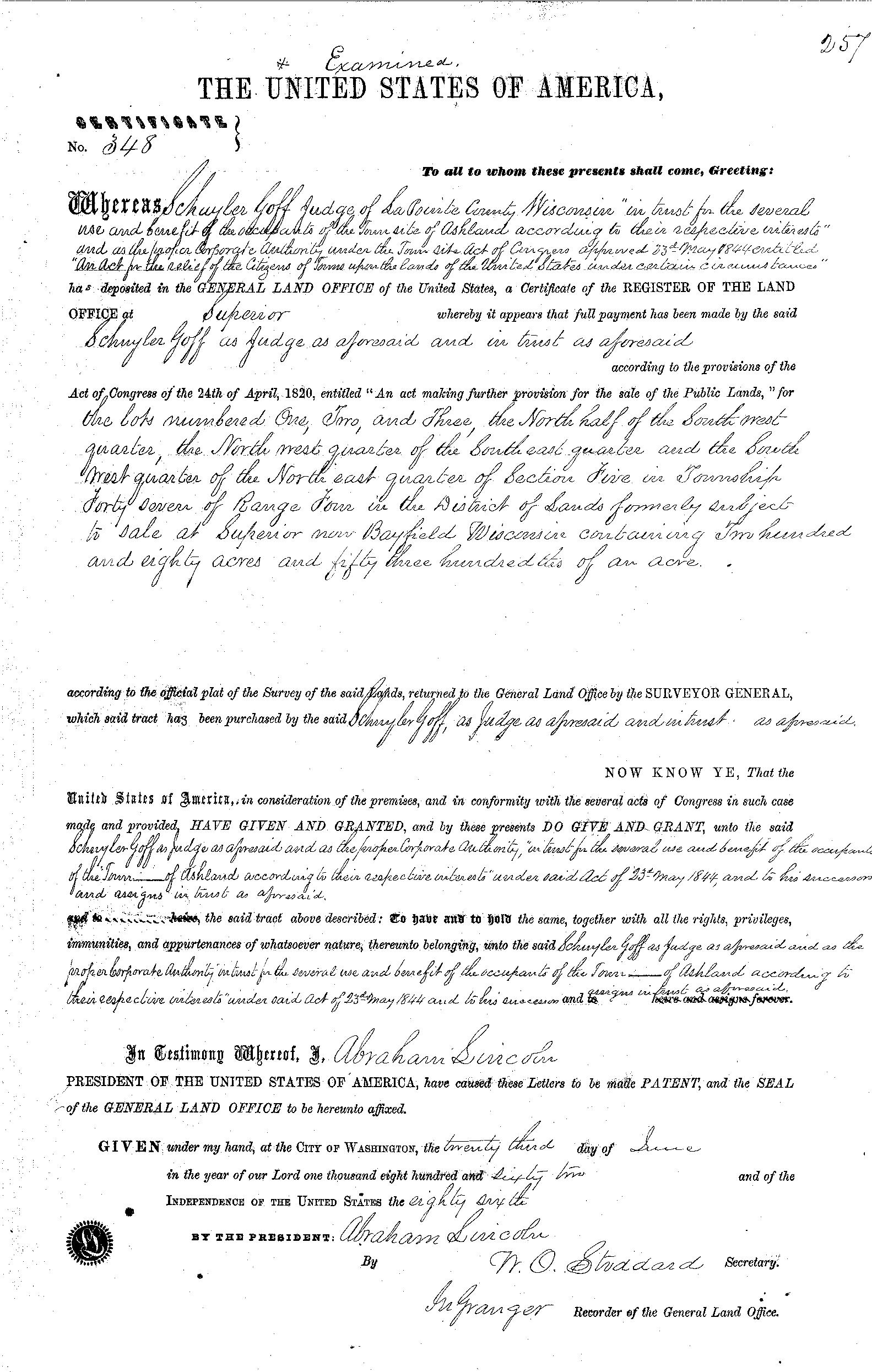
La Pointe County Judge Schuyler Goff was issued this patent for 280.53 acres on June 23rd, 1862, on behalf of Martin Beaser, Asaph Whittlesey, and George Kilburn.
~ General Land Office Records
Mr. Beaser afterwards got his deed from the judge to his three-quarters’ interest in the site.

Beaser named Ashland in honor of the Henry Clay Estate in Kentucky.
~ National Park Service
In January, 1854, Mr. Beaser having previously engaged a topographical engineer, G.L. Brunschweiler, the two, with a dog train and two Indians, made the journey from Ontonagon to the proposed town site, where Mr. Brunschweiler surveyed and platted2 a town on the land of the men before spoken of as parties in interest, to which town Mr. Beaser gave the name of Ashland. These three men, therefore, were the founders of Ashland, although afterwards various additions were made to it.
Mr. Beaser did not bring his family to Ashland until the eighth of September, 1856. He engaged in the mercantile business there until the war broke out, and was drowned in the bay while attempting to come from Bayfield to Ashland in an open boat, during a storm, on the fourth of November, 1866. He was buried on Madeline island at La Pointe. He was “closely identified with enterprises tending to open up the country; was wealthy and expended freely; was a man of fine discretion and good, common sense.” He was never discouraged as to Ashland’s future prosperity.
The children of Mr. Beaser, three in number, are all living: Margaret Elizabeth, wife of James A. Croser of Menominee, Michigan; Percy McLeod, now of Ashland; and Harry Hamlin, also of Ashland, residing with his mother, now Mrs. Wilson, an intelligent and very estimable lady.
1 See ‘History of Northern Wisconsin,’ p. 67.
2 The date of the platting of Ashland by Brunschweiler is taken from the original plat in the possession of the recorder of Ashland county, Wisconsin.
Indian Records of Ontonagon and Bad River
June 11, 2016
By Amorin Mello
![This is a partial reproduction of<strong> <br /> <em>Western Reserve and Northern Ohio</em></strong><br /> <em> <strong> Historical Society</strong></em><br /> <em><strong>[Tract] Number 41</strong></em><br /> <em> <strong> Ancient Earthworks - Northern Ohio</strong></em><br /> by Charles Whittlesey, circa 1877<br /> as published in<br /> <a href="https://books.google.com/books?id=EawKAAAAIAAJ" target="_blank"><strong><span style="text-decoration: underline;">Western Reserve Historical Society Publication, Volume 2</span>,</strong></a><br /> pages 38-39.](https://chequamegonhistory.com/wp-content/uploads/2016/06/wrhs-tract-41.jpg)
This is a partial reproduction of
Western Reserve and Northern Ohio Historical Society
[Tract] Number 41: Ancient Earthworks – Northern Ohio
by Colonel Charles W. Whittlesey, circa 1877,
as republished in
Western Reserve Historical Society Publication, Volume 2,
pages 38-39.
INDIAN RECORDS.

Autobiography of Okandikan
Autobiography of Kundickan, a Chippeway Indian.
The subjoined pictorial record of his life, was made many years since by a Chippeway of Lake Superior. He delivered it to the Hon. A. C. Davis, of Detroit, who placed it in the Museum of the Natural Science Association of that place where it is now. The tracing was made in October, 1875, by Bela Hubbard, of Detroit. The engraving is from a photograph by E. Decker of Cleveland, reduced to one-third the original size.
The signs or characters are cut with a knife on both sides of a flat piece of sugar maple wood, less than one-fourth of an inch thick, wrought out by the Indian himself, for this purpose. The upright lines at a, a, a, appear to be divisions in the narrative, for the purpose of grouping events. He explained to Mr. Davis that this board contained the principal occurrences of his life, which any other Chippeway could read. How it should be read, whether from right to left or the reverse, or whether the inverted parts are to be taken in connection with those below, is not settled. The partitions A and B are colored vermillion red. It corresponds with the general character of the Indian pictorial writing, of which numerous examples are given by Schoolcraft, and shows a close relation to the rock inscriptions of the United States. It embraces the usual variety of uncouth men, animals, and implements which characterize the rock sculptures. Between the two sides of the board there does not appear to be any connection in regard to the sentences or paragraphs, though there must be as to dates. They are all, without much doubt, the work of people in the condition of savages. I saw this Indian on the Ontonagon river in 1845. He purported to have seen Alexander Henry in that region in 1769-70, who was engaged there in mining for copper and silver.

“Pictograph C. Okundekund and his Band of Ontonagon – Michigan,” as reproduced from birch bark by Seth Eastman, and published as Plate 62 in Historical and Statistical Information Respecting the History, Condition, and Prospects of the Indian Tribes of the United States, Volume I., by Henry Rowe Schoolcraft, 1851. Okandian’s pictograph petition was one of several from the 1849 Martell delegation:
“By this scroll, the chief Kun-de-kund of the Eagle totem of the river Ontonagon, of Lake Superior, and certain individuals of his band, are represented as uniting in the object of their visit of Oshcabewis. He is depicted by the figure of an eagle, Number 1. The two small lines ascending from the head of the bird denote authority or power generally. The human arm extended from the breast of the bird, with the open hand, are symbolic of friendship. By the light lines connecting the eye of each person with the chief, and that of the chief with the President, (Number 8,) unity of views or purpose, the same as in pictography Number 1, is symbolized. Number 2, 3, 4, and 5, are warriors of his own totem and kindred. Their names, in their order, are On-gwai-sug, Was-sa-ge-zhig, or The Sky that lightens, Kwe-we-ziash-ish, or the Bad-boy, and Gitch-ee-man-tau-gum-ee, or the great sounding water. Number 6. Na-boab-ains, or Little Soup, is a warrior of his band of the Catfish totem. Figure Number 7, repeated, represents dwelling-houses, and this device is employed to deonte that the persons, beneath whose symbolic totem it is respectively drawn, are inclined to live in houses and become civilized, in other words, to abandon the chase. Number 8 depicts the President of the United States standing in his official residence at Washington. The open hand extended is employed as a symbol of friendship, corresponding exactly, in this respect, with the same feature in Number 1. The chief whose name is withheld at the left hand of the inferior figures of the scroll, is represented by the rays on his head, (Figure 9,) as, apparently, possessing a higher power than Number 1, but is still concurring, by the eye-line, with Kundekund in the purport of pictograph Number 1.”
Inscriptions on Clay Banks, Bad River, Ashland County, Wis.

2

1
A few representations of recently inscribed figures are given for the purpose of comparison with ancient stone inscriptions. A short distance below the portage, across a long, loop-like bend of the Mashkeg or Bad river, above the Odanah Mission, is a perpendicular bluff of clay, on the west bank of the stream. Steep clay and sand bluffs are common through the flat country below the Falls of Bad River. This one has been sheltered by a thick fringe of growing trees, from the wearing effects of storms. It presents quite a smooth, upright face of dry clay; that is easily cut with a knife, about fifty feet long, and about ten to fifteen feet long, and about ten to fifteen feet high. This space is completely covered with picture records, made by the Chippeways. No doubt many of them are old, but most of them have been made recently, or by men now living, often obliterating or cutting new inscriptions over old ones.

4

3
In my explorations on the waters of Bad river in 1846, 1849, and 1860, I passed them repeatedly, but having other objects in view, made only a few sketches. The effigies are grotesque outlines of animals, canoes, birds, fishes, men, women, trees, and other objects, animate and inanimate. My Indians and some of the half-breed voyageurs, professed to be able to read them. They said it was expected that every young man, when he was old enough to become a warrior, should retire to some solitary place and undergo a fast. The length of time he could do without food was a test of his bravery. Sometimes he perched in a tree, day and night, or sat on a rock or on a high mountain, without fire or shelter, in order to show his contempt of pain and exposure. In due time he naturally had visions, in which his destiny or chart of life, was disclosed. Weak constitutions are unable to fast more than three or four days. When the incipient warrior had satisfied himself that his mission on earth was fully disclosed to him, he returned to the tribe and was received a man. Their version of this ceremony, and its consequences agrees generally with that of Chingwauk to Mr. Schoolcraft in 1839, as related in vol. 1, pages 13-14, of his “North American Indians.” The symbols of his destiny were generally put upon record, in such a manner and in such a place as he saw fit, but generally on trees or rocks, along a traveled route. In some cases a full statement of the vision or visions, was written out in this pictorial mode, with his dodem or “totem” attached. I remember the meaning of only one, of which figure No. 2 forms a part. The tree with nine branches, and a hand pointing upward, signifies that the party making it had fasted nine days.

5
There is nothing in their customs to prevent other messages being left in such places. Their records include nothing historical in regards to the nations or their chiefs. Such matters are perpetuated by repetition from the old to the young, until every young man is thoroughly crammed. General story telling, and the recital of their traditions, is the literary life work of an Indian. His memory is a mental record, transmitted from generation to generation. The fidelity of such records is, however, very far from reliable.
Figures one to five are random copies from a large number of the Bad river effigies, not made to scale, but they are fair representatives of Indian pictography.
