By Leo
In April, the Supreme Court heard arguments in the case Department of Commerce v. New York and could render a decision any day on whether or not the 2020 federal census should include a question asking about citizenship status. In January, a Federal District Court in New York ruled that commerce secretary, Wilbur Ross, violated the law by pushing for that question.
Those in agreement with the District ruling suggest that the Trump administration wants to add the question as a way of discouraging immigrants from participating in the census, thereby diminishing the political power of immigrant communities. This, they say, would violate the Constitution on the grounds that the census must be an “actual enumeration” of all persons within the United States, not only citizens.
Proponents of the citizenship question counter that citizenship status is a perfectly natural question to ask in the census, that any government would want to know how many citizens it has, and that several past iterations of the 10-year count have included similar questions.
It remains to be seen how the Supreme Court will rule, but chances are it will not be the last time an issue of race, identity, or citizenship pops up in the politics of the census. From its creation by the Constitution as a way to apportion seats in congress according to populations of the states, the count has always begged tricky questions that essentially boil down to:
Who is a real American? Who isn’t? Who is a citizen? Who is three-fifths of a human being? Who might not be human at all? What does it mean to be White? To be Colored? To be civilized? How do you classify the myriad of human backgrounds, cultures and stories into finite, discrete “races?”
The Civil War and Fourteenth Amendment helped shed light on some of these questions, but it would be a mistake to think that they belong to the past. The NPR podcast Codeswitch has done an excellent series on census, and this episode from last August gives a broad overview of the history.
Here at Chequamegon History, though, we aren’t in the business broad overviews. We are going to drill down right into the data. We’ll comb through the 1850 federal census for La Pointe County and compare it with the 1860 data for La Pointe and Ashland Counties. Just for fun, we’ll compare both with the 1855 Wisconsin State Census for La Pointe County, then double back to the 1840 federal census for western St. Croix County. Ultimately, the hope is to help reveal how the population of the Chequamegon region viewed itself, and ultimately how that differed from mainstream America’s view. With luck, that will give us a framework for more stories like Amorin’s recent post on the killing of Louis Gurnoe.
Background
 Judge Daniel Harris Johnson of Prairie du Chien had no apparent connection to Lake Superior when he was appointed to travel northward to conduct the census for La Pointe County in 1850. The event made an impression on him. It gets a mention in his short memorial biography in the 1902 Proceedings of the State Bar Association.
Two years after statehood, Lake Superior’s connection to the rest of Wisconsin was hardly existent. This was long before Highways 51 and 53 were built, and commerce still flowed west to east. Any communication to or from Madison was likely to first go through Michigan via Mackinaw and Sault Ste. Marie, or through Minnesota Territory via St. Paul, Stillwater, and Sandy Lake. La Pointe County had been created in 1845, and when official business had to happen, a motley assortment of local residents who could read and write English: Charles Oakes, John W. Bell, Antoine Gordon, Alexis Carpentier, Julius Austrian, Leonard Wheeler, etc. would meet to conduct the business.
It is unclear how much notice the majority Ojibwe and French-patois speaking population took of this or of the census generally. To them, the familiar institutions of American power, the Fur Company and the Indian Agency, were falling apart at La Pointe and reorganizing in St. Paul with dire consequences for the people of Chequamegon. When Johnson arrived in September, the Ojibwe people of Wisconsin had already been ordered to remove to Sandy Lake in Minnesota Territory for their promised annual payments for the sale of their land. That fall, the government would completely botch the payment, and by February, hundreds of people in the Lake Superior Bands would be dead from starvation and disease.
So, Daniel Johnson probably found a great deal of distraction and anxiety among the people he was charged to count. Indians, thought of by the United States as uncivilized federal wards and citizens of their own nations, were typically not enumerated. However, as I wrote about in my last post, race and identity were complicated at La Pointe, and the American citizens of the Chequamegon region also had plenty to lose from the removal.
Madison, for its part, largely ignored this remote, northern constituency and praised the efforts to remove the Ojibwe from the state. It isn’t clear how much Johnson was paying attention to these larger politics, however. He had his own concerns:


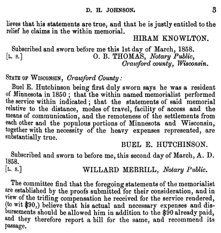
House Documents, Volume 119, Part 1. U.S. Government Printing Office, 1859. Google Books.
So, in “that thinly settled and half civilized region,” Johnson only found a population of about 500, “exclusive of Indians.” He didn’t think 500 was a lot, but by some counts, that number would have seemed very high. Take the word of a European visitor to La Pointe:
Among 200 Indians, only a few white families live there. One of the boatmen gave us a name, with which we found Mr. Austrian.
And, from this Mr. Austrian, himself:
There were only about 6 white American inhabitants on the Island, about 50 Canadian Frenchmen who were married to squaws, and a number of full blooded Indians, among whom was chief Buffalo who was a descendant of chiefs & who was a good Indian and favorably regarded by the people.
~Joseph Austrian, Brother of Julius and La Pointe resident 1851-52
Who lived around La Pointe in 1850?
In her biography, William W. Warren: the Life, Letters, and Times of an Ojibwe Leader, Theresa Schenck describes the short life of an ambitious young man from La Pointe. William Whipple Warren (1825-1853) grew up on the Island speaking Ojibwe as his first language. His father was a Yankee fur trader from New York. His mother was a daughter of Michel and Madeline Cadotte. In his famous History of the Ojibways Warren describes the Ojibwe as people with whom he readily claims kinship, but he doesn’t write as if he is an Ojibwe person himself. However, he helped interpret the Treaty of 1847 which had definitively made him an Indian in the eyes of the United States (a fact he was willing to use for economic gain). Still, a few years later, when he became a legislator in Minnesota Territory he dismissed challenges to his claims of whiteness.
If he were alive today, Warren might get a chuckle out of this line from the South African comedian Trevor Noah.
People mocked me. Gave me names like mixed breed, half caste — I hate that term ‘half’. Why half? Why not double? Or twice as nice, I don’t know.
— Trevor Noah
William Warren did not see himself as quite the walking contradiction we might see him as today. He was a product of the time and place he came from: La Pointe. By 1850, he had left that place, but his sister and a few hundred of his cousins still lived there. Many of them were counted in the census.
What is Metis?
Half-breeds, Mixed-bloods, Frenchmen, Wiisakodewininiwag, Mitif, Creoles, Metis, Canadiens, Bois Brules, Chicots, French-of-the-country, etc.–at times it seems each of these means the same thing. At other times each has a specific meaning. Each is ambiguous in its own way. In 1850, roughly half the families in the Chequamegon area fit into this hard-to-define category.


Kohl, J. G. Kitchi-Gami: Wanderings around Lake Superior. London: Chapman and Hall, 1860. pg. 260-61.
We were accompanied on our trip throughout the lakes of western Canada by half-Indians who had paternal European blood in their veins. Yet so often, a situation would allow us to spend a night inside rather than outdoors, but they always asked us to choose to Irish camp outside with the Indians, who lived at the various places. Although one spoke excellent English, and they were drawn more to the great American race, they thought, felt, and spoke—Indian! ~Carl Scherzer
In describing William Warren’s people, Dr. Schenck writes,
Although the most common term for people of mixed Indian and European ancestry in the nineteenth century was “half-breed,” the term “mixed blood” was also used. I have chosen to use the latter term, which is considered less offensive, although biologically inaccurate, today. The term “métis” was not in usage at the time, except to refer to a specific group of people of mixed ancestry in the British territories to the north. “Wissakodewinini,” the word used by the Ojibwe, meant “burned forest men,” or bois brulés in French, so called because half-breeds were like the wood of a burned forest, which is often burned on one side, and light on the other (pg. xv).
Schenck is correct in pointing out that mixed-blood was far more commonly used in 19th-century sources than Metis (though the latter term did exist). She is also correct in saying that the term is more associated with Canada and the Red River Country. There is an additional problem with Metis, in that 21st-century members of the Wannabe Tribe have latched onto the term and use it, incorrectly, to refer to anyone with partial Native ancestry but with no affiliation to a specific Indian community.
That said, I am going to use Metis for two reasons. The first is that although blood (i.e. genetic ancestry) seemed to be ubiquitous topic of conversation in these communities, I don’t think “blood” is what necessarily what defined them. The “pure-blooded French Voyageur” described above by Kohl clearly saw himself as part of Metis, rather than “blanc” society. There were also people of fully-Ojibwe ancestry who were associated more with Metis society than with traditional Ojibwe society (see my post from April). As such, I find Metis the more versatile and accurate term, given that it means “mixed,” which can be just as applicable to a culture and lifestyle as it is to a genetic lineage.
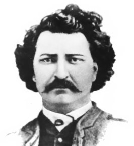
One time Canadian pariah turned national hero, Louis Riel and his followers had cousins at La Pointe (Photo: Wikipedia)
The second reason I prefer Metis is precisely because of the way it’s used in Manitoba. Analogous to the mestizo nations of Latin America, Metis is not a way of describing any person with Native and white ancestry. The Metis consider themselves a creole-indigenous nation unto themselves, with a unique culture and history. This history, already two centuries old by 1850, represents more than simply a borrowed blend of two other histories. Finally, the fur-trade families of Red River came from Sault Ste. Marie, Mackinac, Grand Portage, and La Pointe. There were plenty of Cadottes, Defaults, Roys, Gurnoes, and Gauthiers among them. There was even a Riel family at La Pointe. They were the same nation
Metis and Ojibwe Identity in the American Era
When the 1847 Treaty of Fond du Lac “stipulated that the half or mixed bloods of the Chippewas residing with them shall be considered Chippewa Indians, and shall, as such, be allowed to participate in all annuities which shall hereafter be paid…” in many ways, it contradicted two centuries of tradition. Metis identity, in part, was dependent on not being Indian. They were a minority culture within a larger traditional Anishinaabe society. This isn’t to say that Metis people were necessarily ashamed of their Native ancestors–expressions of pride are much easier to find than expressions shame–they were just a distinct people. This was supposedly based in religion and language, but I would argue it came mostly from paternal lineage (originating from highly-patriarchal French and Ojibwe societies) and with the nature of men’s work. For women, the distinction between Ojibwe and Metis was less stark.
The imposition of American hegemony over the Chequamegon region was gradual. With few exceptions, the Americans who came into the region from 1820 to 1850 were adult men. If new settlers wanted families, they followed the lead of American and British traders and married Metis and Ojibwe women.
Still, American society on the whole did not have a lot of room for the racial ambiguity present in Mexico or even Canada. A person was “white” or “colored.” Race mixing was seen as a problem that affected particular individuals. It was certainly not the basis for an entire nation. In this binary, if Metis people weren’t going to be Indian, they had to be white.
The story of the Metis and American citizenship is complicated and well-studied. There is risk of overgeneralizing, but let’s suffice to say that in relation to the United States government, Metis people did feel largely entitled to the privileges of citizenship (synonymous with whiteness until 1865), as well as to the privileges of Ojibwe citizenship. There wasn’t necessarily a contradiction.
Whatever qualms white America might have had if they’d known about it, Metis people voted in American elections, held offices, and were counted by the census.
Ojibwe “Full-bloods” and the United States Census
Representatives and direct Taxes shall be apportioned among the several States which
may be included within this Union, according to their respective Numbers, which shall be determined by adding to the whole Number of free Persons, including those bound to Service for a Term of Years, and excluding Indians not taxed, three fifths of all other Persons. The actual Enumeration shall be made within three Years after the first Meeting of the Congress of the United States, and within every subsequent Term of ten Years, in such Manner as they shall by Law direct.~Excerpt from Article I Section II, U. S. Constitution
As I argued in the April post, our modern conception of “full-blood” and “mixed-blood” has been shaped by the “scientific” racism of the late 19th and early 20th centuries. The distinction, while very real in a cultural sense, was not well-grounded in biology.
The relationship of Indians (i.e. full-bloods or those living a traditional lifestyle) to American society and citizenship was possibly more contradictory then that of the Metis. In one sense, America saw Indians as foreigners on their own continent: either as enemies to be exterminated, or as domestic-dependent ward nations to be “protected.” The constitutional language about the census calls for slaves to be counted as three-fifths of a person. It says Indians shouldn’t be counted at all.
In another sense, however, the path to personhood in America was somewhat clearer for Indians than it was for African Americans. Many New England liberals saw exodus to Liberia as the only viable future for free blacks. These same voices felt that Indians could be made white if only they were separated from their religions, cultures, and tribal identities. In 1834, to avoid a second removal, the Brothertown Indians of Wisconsin petitioned congress for citizenship and the termination of collective title to their tribal lands. In 1839, their request was granted. In the eyes of the law, they had effectively become white. Other communities would follow suit. However, most Native people did not gain any form of American citizenship until 1924.
How did that play out for the Ojibwe people of Chequamegon, and how did it impact the 1850 census? Well, it’s complicated.
Race, the Census, and Classifying Households
The enumeration forms Daniel H. Johnson carried to La Pointe had more rows and columns than ever. The Seventh Census was the first to count everyone in the household by name (previous versions only listed the Head of Household with tally marks). It was also the first census to have a box for “color.” Johnson’s choices for color were “white,” “black,” and “mulatto,” forcing him to make some decisions.
He seems to have tried to follow the Indians not taxed clause strictly. 40-50% of households in the region were headed by a full-blood Ojibwe person, possibly only two of them were enumerated. You won’t find Chief Buffalo, Makadebinesi (Blackbird), Oshkinaawe, Omizhinaawe, Edawegiizhig, and their immediate families in the 1850 census. Jechiikwii’o (often called Little Buffalo) is not in the document, even though he was an early Catholic convert, dressed in “white” clothing, and counted more Metis Ojibwe among his followers than full-bloods. However, his son, Antoine Buffalo Sr. (Antoine Jachequaon) is counted. Antoine, along with George Day, were counted as white heads of household by the census, though it is unclear if they had any European ancestry (Sources conflict. If anyone has genealogical information for the Buffalo and Day families, feel free to comment on the post). A handful of individuals called full-bloods in other sources, were listed as white. This includes 90-year old Madeline Cadotte, Marie Bosquet, and possibly the Wind sisters (presumably descendants of Noodin, one of the St. Croix chiefs who became Catholic and relocated to La Pointe around this time). They were married to Metis men or lived in Metis households. All Metis were listed as white.
Johnson did invent new category for five other Ojibwe people: “Civilized Indian,” which he seemed to use arbitrarily. Though also living in Metis households, Mary Ann Cadotte, Osquequa Baszina, Marcheoniquidoque, Charlotte Houle, and Charles Loonsfoot apparently couldn’t be marked white the way Madeline Cadotte was. These extra notations by Johnson and other enumeration marshals across the country are why the Seventh Federal Census is sometimes referred to as the first to count Native Americans.

So, out of 470 individuals enumerated at La Pointe and Bad River (I’ve excluded Fond du Lac from my study) Johnson listed 465 (99%) as white. By no definition, contemporary or modern, was the Chequamegon area 99% white in 1850. The vast majority of names on the lines had Ojibwe ancestry, and as Chippewas of Lake Superior, were receiving annuities from the treaties.
There were a few white American settlers. The Halls had been at La Pointe for twenty years. The Wheelers were well-established at Odanah. Junius and Jane Welton had arrived by then. George Nettleton was there, living with a fellow Ohioan James Cadwell. The infamous Indian agent, John Watrous, was there preparing the disastrous Sandy Lake removal. Less easy to describe as American settlers, but clearly of European origins, Fr. Otto Skolla was the Catholic priest, and Julius Austrian was the richest man it town.
There were also a handful of American bachelors who had drifted into the region and married Metis women. These first-wave settlers included government workers like William VanTassel, entrepreneurs like Peter VanderVenter, adventurers with an early connection to the region like Bob Boyd and John Bell, and homesteaders like Ervin Leihy.
It is unclear how many of French-surnamed heads of household were Chicots (of mixed ancestry) and how many were Canadiens (of fully-French ancestry). My sense is that it is about half and half. Some of this can be inferred from birthplace (though a birthplace of Canada could indicate across the river at Sault Ste. Marie as easily it could a farm in the St. Lawrence Valley). Intense genealogical study of each family might provide some clarifications, but I am going to follow Kohl’s voyageurs and not worry too much about it. Whether it was important or not to Jean Baptiste Denomie and Alexis Carpentier that they had no apparent Indian ancestry and that they had come from “the true homeland” of Quebec, for all intents and purposes they had spent their whole adult lives in “the Upper Country,” and their families were “of the Country.” They were Catholic and spoke a form of French that wasn’t taught in the universities. American society would not see them as white in the way it saw someone like Sherman Hall as white.
So, by my reckoning, 435 of the 470 people counted at La Pointe (92.5%) were Metis, full-blood Ojibwe living in Metis households, or Canadians in Metis families. Adding the five “Civilized Indians” and the six Americans married into Metis families, the number rises to 95%. I am trying to track down accurate data on the of Indians not taxed (i.e. non-enumerated full-bloods) living at or near La Pointe/Bad River at this time. My best estimates would put it roughly the same as the number of Metis. So, when Johnson describes a land with a language and culture foreign to English-speaking Americans, he’s right.
Birthplace, Age, and Gender
Ethnic composition is not the only data worth looking at if we want to know what this area was like 169 years ago. The numbers both challenge and confirm assumptions of how things worked.
Let’s take mobility for example:

The young voyageur quoted by Kohl may have felt like he didn’t have a home other than en voyage, but 86% of respondents reported being born in Wisconsin. Except for ten missionary children, all of these were Metis or “Civilized Indian.” Wisconsin could theoretically mean Lac du Flambeau, Rice Lake, or even Green Bay, this but this number still seemed high to me. I’m guessing more than 14% of 21st-century Chequamegon residents were born outside the state, and 19th-century records are all about commerce, long-distance travel, and new arrivals in new lands. We have to remember that most of those records are coming from that 14%.
In September of 1850 the federal government was telling the Ojibwe of Wisconsin they needed to leave Wisconsin forever. How the Metis fit into the story of the Sandy Lake Tragedy has always been somewhat fuzzy, but this data would indicate that for a clear majority, it meant a serious uprooting.
For those born outside Wisconsin, more than two-thirds reported being born in Michigan, Canada, or Minnesota Territory. These are overwhelmingly Metis or in the case of Anglo-Canadians like Robert Morrin, heads of Metis households from areas with a fur-trade tradition. Only eighteen individuals reported being born in the eastern United States. Only three reported Europe.
I had more questions than assumptions about the gender and age breakdown of the population. Would there be more women than men because of the dangerous jobs done by men or would mortality from childbirth balance that out? Or maybe widows wouldn’t be counted if they returned to the wigwams of their mothers? How would newcomers skew the age and gender demographics of the area?
Let’s take a look:
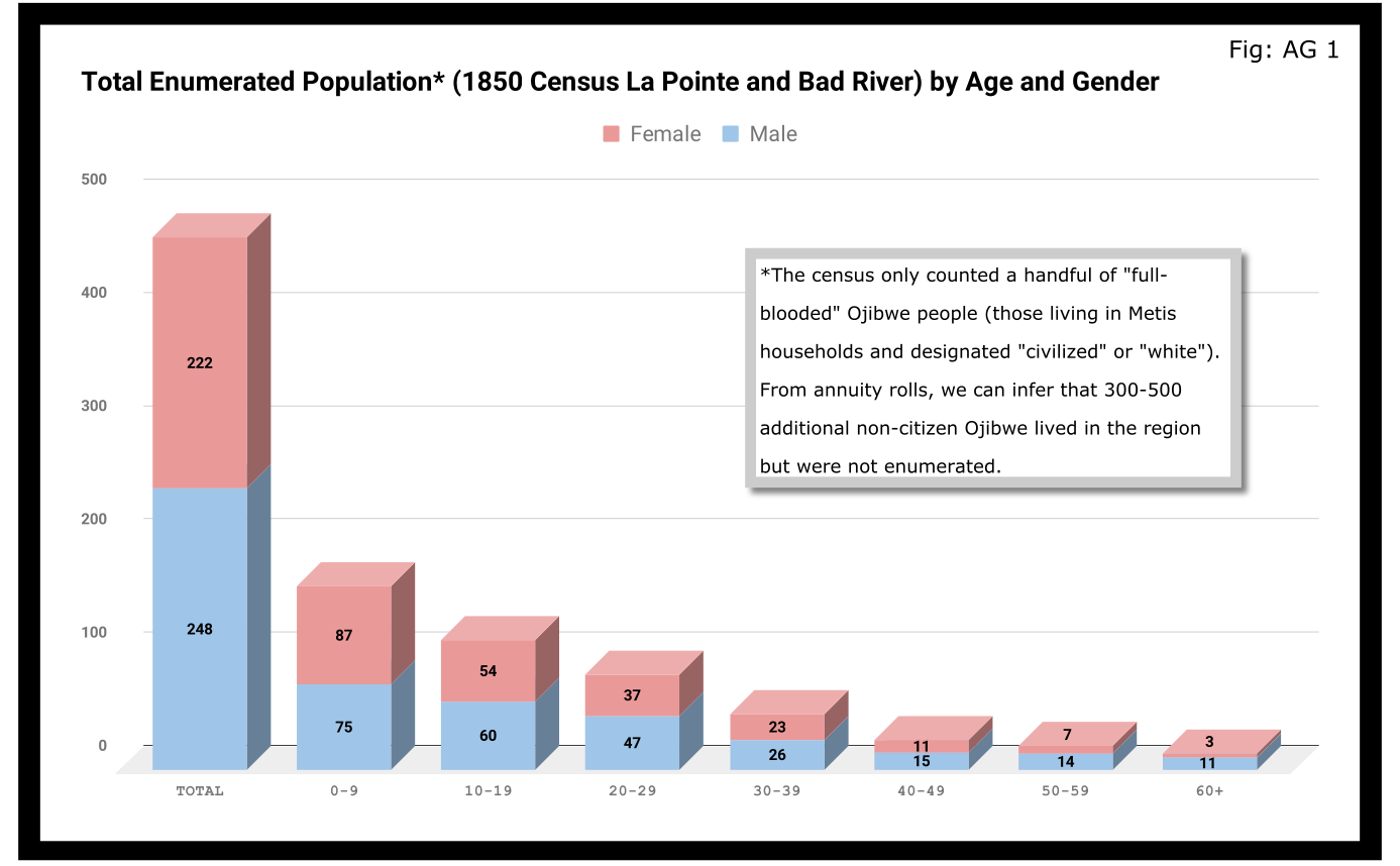
A quick glance at Figure AG 1 shows that the population skewed male 248-222 and skewed very young (61% under 20 years old). On the eve of Sandy Lake, the natural increase in the population seemed to be booming.

The hypotheses that women had higher mortality rates and were more likely to be undercounted looked good until we limit the data to the Wisconsin-born population. In Figure AG 2, we see that the male majority disappears entirely. The youthful trend, indicating large families and a growing population, continues with 66% of the Wisconsin-born population being under 20.

The male skew of the total population was entirely due to those born outside Wisconsin. This is not surprising given how much we’ve emphasized the number of men who came into the Lake Superior country to marry local women.
A look at the oldest residents in chart AG 2 and AG 3 hints at another story. Madeline Cadotte is the only Wisconsin-born person over seventy to be counted. The oldest men all came from Michigan and Canada. Why? My hypothesis is that between the fall of New France in 1759 and the establishment of Michel Cadotte’s post sometime around 1800, there wasn’t a large population or a very active fur trade around La Pointe proper. That meant Cadotte’s widow and other full bloods were the oldest locally-born residents in 1850. Their Metis contemporaries didn’t come over from the Soo or down from Grand Portage until 1810 or later.
Economics
Before the treaties, the economy of this area was built on two industries: foraging and trade. Life for Ojibwe people revolved around the seasonal harvest of fish, wild rice, game, maple sugar, light agriculture, and other forms of gathering food directly from the land. Trade did not start with the French, and even after the arrival of European goods into the region, the primary purpose of trade seemed to be for cementing alliances and for the acquisition of luxury goods and sacred objects. Richard White, Theresa Schenck, and Howard Paap have all challenged the myth of Ojibwe “dependence” on European goods for basic survival, and I find their arguments persuasive.
Trade, though, was the most important industry for Metis men and La Pointe was a center of this activity. The mid-19th century saw a steep decline in trade, however, to be replaced by a toxic cycle of debts, land sales, and annuity payments. The effects of this change on the Metis economy and society seem largely understudied. The fur trade though, was on its last legs. Again, the Austrian travel writer Carl Scherzer, who visited La Pointe in 1852:
After this discussion of the of the rates of the American Fur Company and its agents, we want to add some details about the men whose labor and time exerted such a great influence on the fate and culture of the Indian tribes. We wish to add a few explanatory words about the sad presence on La Pointe of the voyageurs or courriers du bois.
This peculiar class of people, which is like a vein of metal that suddenly disappears within the bedrock and reappears many hundreds of miles away under the same geological conditions, their light reaches the borders of the eastern Canadas. The British people, with their religion and customs, reappeared on the shores of these northern lakes only in 1808 with the Fur Company. For labor they drew on those who could carry their wares across the lakes and communicate with the Indians.
Many young men of adventurous natures left the old wide streets of Montreal and moved into the trackless primeval forests of the West. Young and strong as laborers, they soon started to adopt the lifestyle and language of the aborigines. They married with the Indians and inhabit small settlements scattered throughout those mighty lands which begin at Mackinow Island and come up the upper lake to the region of Minnesota. They almost all speak the Canadian patois along with the language of the Chippewas, the tribe with which they came into kinship. We found only a few, even among the younger generation, who understood English.
Since then, every day the population of the otherwise deserted shore of Lake Superior increases with the discovery of copper mines. The animals driven away by the whirlwind of civilization toward the west, attract the Indians with their sensitive guns, leaving La Pointe, abandoned by the Company for their headquarters at St. Paul in Minnesota. Most voyageurs left the island, having seen their business in ruins and lacking their former importance. Just a few families remain here, making a meager livelihood of hunting, fishing, and the occasional convoy of a few travelers led by business, science, or love of nature who purchase their limited resources.
From Scherzer’s description, two things are clear. It’s pretty clear from the flowery language of the Viennese visitor.Washington Irving and other Romantic-Era authors had already made the Voyageur into the stock stereotypical character we all know today. Th only change, though, is these days voyageurs are often depicted as representatives of white culture, but that’s a post for another time.
The second item, more pertinent to this post, is that a lot of voyageurs were out of work. This is especially relevant when we look at our census data. Daniel Johnson recorded the occupations of all males fifteen or over:
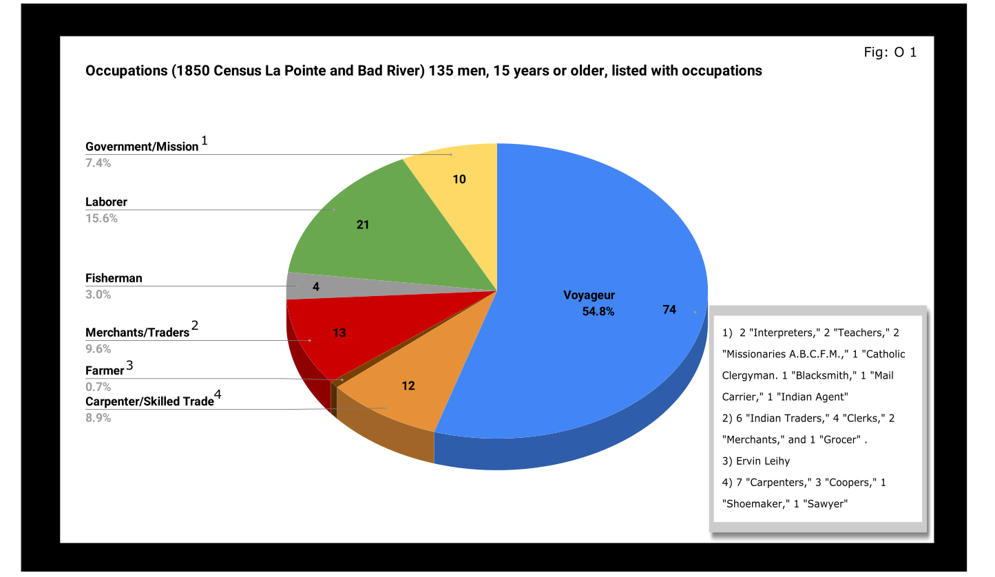
A full 55% of enumerated men fifteen and older still identified themselves as voyageurs in 1850. This included teenagers as well as senior citizens. All were from Metis households, though aside from farmer, all of the other occupation categories in Figure O 1 included Metis people.

A look at household sizes did not show voyageurs having to support significantly larger or smaller families when compared to the other occupation categories.
The other piece of economic data collected was value of real estate. Here we see some interesting themes:

If real estate is a good proxy for wealth in a farming community, it is an imperfect one in the Chequamegon area of 1850. If a voyageur had no home but the river and portage, then we might not expect him to put his coin into land and buildings. A teacher or Indian agent might draw a consistent salary but then live in supplied housing before moving on. With that caveat, let’s dig into the data.
Excluding the single farmer, men in the merchant/trader group controlled the most wealth in real estate, with Julius Austrian controlling as much as the other merchants combined. Behind them were carpenters and men with specific trades like cooper or shoemaker. Those who reported their occupation generally as “laborer” were not far behind the tradesmen. I suspect their real estate holdings may be larger and less varied than expected because of the number of sons and close relatives of Michel Cadotte Sr. who identified themselves as laborers. Government and mission employees held relatively little real estate, but the institutions they represented certainly weren’t lacking in land or power. Voyageurs come in seventh, just behind widows and ahead of fishermen of which there were only four in each category.
It is interesting, though, that the second and third richest men (by real estate) were both voyageurs, and voyageur shows a much wider range of households than some of the other categories: laborers in particular. With the number of teenagers calling themselves voyageurs, I suspect that the job still had more social prestige attached to it, in 1850, than say farmer or carpenter.
With hindsight we know that after 1854, voyageurs would be encouraged to take up farming and commercial fishing. It is striking, however, how small these industries were in 1850. Despite the American Fur Company’s efforts to push its Metis employees into commercial fishing in the 1830s, and knowing how many of the family names in Figure O 3 are associated with the industry, commercial fishing seemed neither popular nor lucrative in 1850. I do suspect, however, that the line between commercial and subsistence fishing was less defined in those days and that fishing in general was seen as falling back on the Indian gathering lifestyle. It wouldn’t be surprised if all these families were fishing alongside their Ojibwe relatives but didn’t really see fishing (or sugaring, etc.) as an occupation in the American sense.
Finally, it could not have escaped the voyageurs notice that while they were struggling, their former employers and their employers educated sons were doing pretty well. They also would have noticed that it was less and less from furs. Lump annuity payments for Ojibwe land sales brought large amounts of cash into the economy one day a year. It must have felt like piranhas with blood in the water. Alongside their full-blood cousins, Metis Ojibwe received these payments after 1847, but they had more of a history with money and capitalism. Whether to identify with the piranha or the prey would have depended on all sorts of decisions, opportunities and circumstances.
Education and Literacy
The census also collected data on education and literacy, asking whether children had attended school within the year, and whether adults over twenty could read and write. The history of white education efforts in this area are fairly well documented. The local schools in 1850 were run by the American Board of Commissioners of Foreign Missions (A.B.C.F.M.) at the La Pointe and Odanah missions, and an entire generation had come of age at La Pointe in the years since Rev. Sherman Hall first taught out of Lyman Warren’s storehouse in 1831. These Protestant ministers and teachers railed against the papists and heathens in their writings, but most of their students were Catholic or traditional Ojibwe in religion. Interestingly, much of the instruction was done in the Ojibwe language. Unfortunately, however, the census does not indicate the language an individual is literate in. I highly recommend The Ojibwe Journals of Edmund F. Ely, 1833-1849 if you are interested in these topics.
To start with, though, let’s look at how many people were going to school:

Thirty-nine students had gone to school in the previous year. There is a lot of sample-size noise in the data, but it seems like ages 7-11 (what we would call the upper-elementary years) were the prime years to attend school.
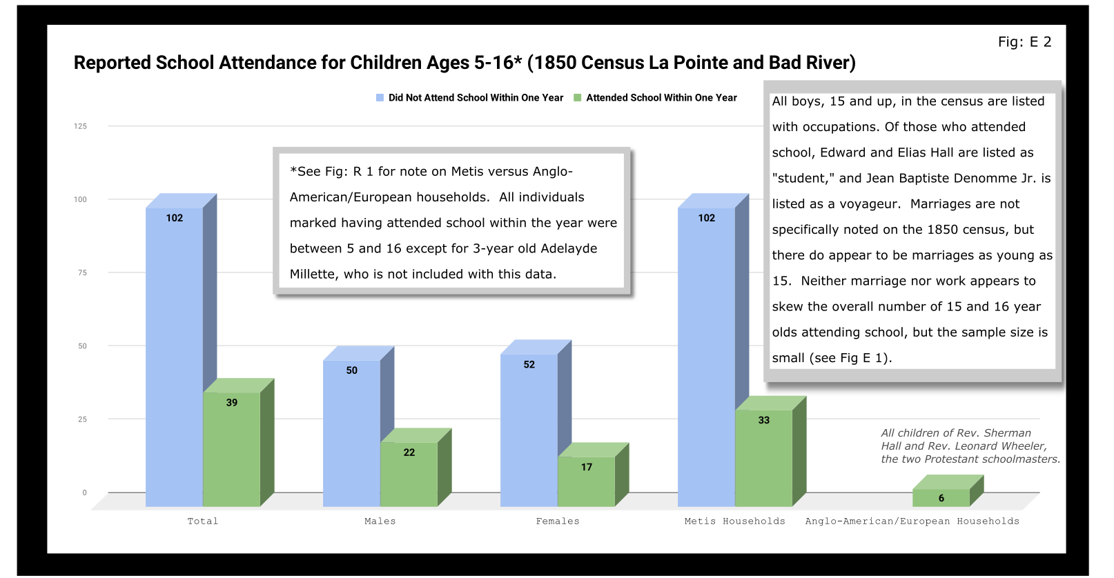
Overall, most children had not attended school within the year. Attendance rates were slightly higher for boys than for girls. White children, all from two missionary families, had a 100% attendance rate compared to 24% for the Metis and “Civilized Indian” children.
We should remember, however, that not attending school within the year is not the same as having never attended school. Twelve-year-old Eliza Morrin (later Morrison) is among the number that didn’t attend school, but she was educated enough to write her memoirs in English, which was her second language. They were published in 2002 as A Little History of My Forest Life, a fascinating account of Metis life in the decades following 1854.
Eliza’s parents were among the La Pointe adults who could read and write. Her aunt, uncle, and adult cousins in the neighboring Bosquet (Buskey) house were not. Overall, just over half of adults over 20 were illiterate without a significant gender imbalance. Splitting by birthplace, however, shows the literacy rate for Wisconsin-born (i.e. Metis and “Civilized Indian”) was only 30%, down from the overall male literacy rate of 48%. For Wisconsin-born women, the drop is only three points, from 47% to 44%. This suggests Metis women were learning to read while their husbands and brothers (perhaps en voyage) were not.

And this is exactly what the data say when we split by occupation. The literacy rate for voyageurs was only 13%. This beats fisherman–all four were illiterate–but lagged far behind all other types of work.
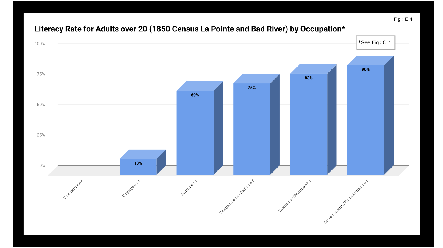
If education was going to be a factor in the economic mobility of unemployed voyageurs, the trends weren’t looking good.
Odds and Ends
Two marriages were reported as occurring in the year previous to the census: Peter and Caroline Vanderventer and Pierre and Marguerite Robideaux (ak.a. Peter and Margaret Rabideaux). Though married, however, Caroline was not living with her husband, a 32-year old grocer from New York. She (along with their infant daughter) was still in the home of her parents Benjamin and Margaret Moreau (Morrow). The Vanderventers eventually built a home together and went on to have several more children. It appears their grandson George Vanderventer married Julia Rabideaux, the granddaughter of Peter and Margaret.
I say appears in the case of George and Julia, because Metis genealogy can be tricky. It requires lots of double and triple checking. Here’s what I came across when I once tried to find an unidentified voyageur known only as Baptiste:

Sometimes it feels like for every Souverain Denis or Argapit Archambeau, there are at least 15 Jean-Baptiste Cadottes, 12 Charles Bresettes, 10 Francois Belangers and 8 Joseph DeFoes. Those old Canadian names had a way of persisting through the generations. If you were a voyageur at La Pointe in 1850, there was nearly a 30% chance your name was Jean-Baptiste. To your friends you might be John-Baptist, Shabadis, John, JB, or Battisens, and you might be called something else entirely when the census taker came around.
The final column on Daniel Johnson’s census asked whether the enumerated person was “deaf and dumb, blind, insane, idiotic, pauper, or convict.” 20 year-old Isabella Tremble, living in the household of Charles Oakes, received the unfortunate designation of idiotic. 26-year-old Francois DeCouteau did not have a mark in that column, but had “Invalid” entered in for his occupation. It’s fair to say we’ve made some progress in the treatment of people with disabilities.
Final Thoughts
I am not usually a numbers person when it comes to history. I’ll always prefer a good narrative story, to charts, tables, and cold numbers. Sometimes, though, the numbers help tell the story. They can help us understand why when Louis Gurnoe was killed, no one was held accountable. At the very least, they can help show us that the society he lived in was under significant stress, that the once-prestigious occupation of his forefathers would no longer sustain a family, and that the new American power structure didn’t really understand or care who his people were.
Ultimately, the census is about America describes itself. From the very beginning, it’s never been entirely clear if in E. pluribus unum we should emphasize the pluribus or the unum. We struggled with that in 1850, and we still struggle today. To follow the Department of Commerce v. New York citizenship case, I recommend Scotusblog. For more census posts about this area in the 19th century, keep following Chequamegon History.
Sources, Data, and Further Reading
-
Paap, Howard D. Red Cliff, Wisconsin a History of an Ojibwe Community ; Volume 1 The Earliest Years: the Origin to 1854. North Star Press of St. Cloud, Inc., 1854.
-
Satz, Ronald N. Chippewa Treaty Rights: the Reserved Rights of Wisconsin’s Chippewa Indians in Historical Perspective. University of Wisconsin Press, 1997.
-
Original Census Act of May 23, 1850 (includes form and instructions for marshals). (PDF)
-
Compiled data spreadsheets (Google Drive Folder) I’ll make these a lot more user friendly in future census posts. By the time it occurred to me that I should include my tables in this post, most of them were already done in tally marks on scrap paper.
-
Finally, these are the original pages, scanned from microfilm by FamilySearch.com. I included the image for Fond du Lac (presumably those living on the Wisconsin side of the St. Louis River) even though I did not include it in any of the data above.
-

- Bad River
-
- Fond du Lac (not included in above data)





Asaph Whittlesey Incidents: Number VI
April 17, 2019
By Amorin Mello

Originally published in the March 23, 1878, issue of The Ashland Press. Transcribed with permission from Ashland Narratives by K. Wallin and published in 2013 by Straddle Creek Co.
… continued from Number V.
Early Recollections of Ashland: Number VI
by Asaph Whittlesey
—
During 1856 the steamers Lady Elgin, Illinois, and Superior landed freight and passengers upon a steamboat dock constructed at Bay City, now Ellis division of Ashland.

1860 photograph of the sidewheel steamer Lady Elgin.
~ Ship-Wrecks.net
Ashland’s first saloon was opened by James Whitney in June 1856, and during the same month the first store was opened by Martin Beaser, on the corner of block one hundred and one.
The patent to Ashland, issued by the United States, bears the date June 23rd, 1862.
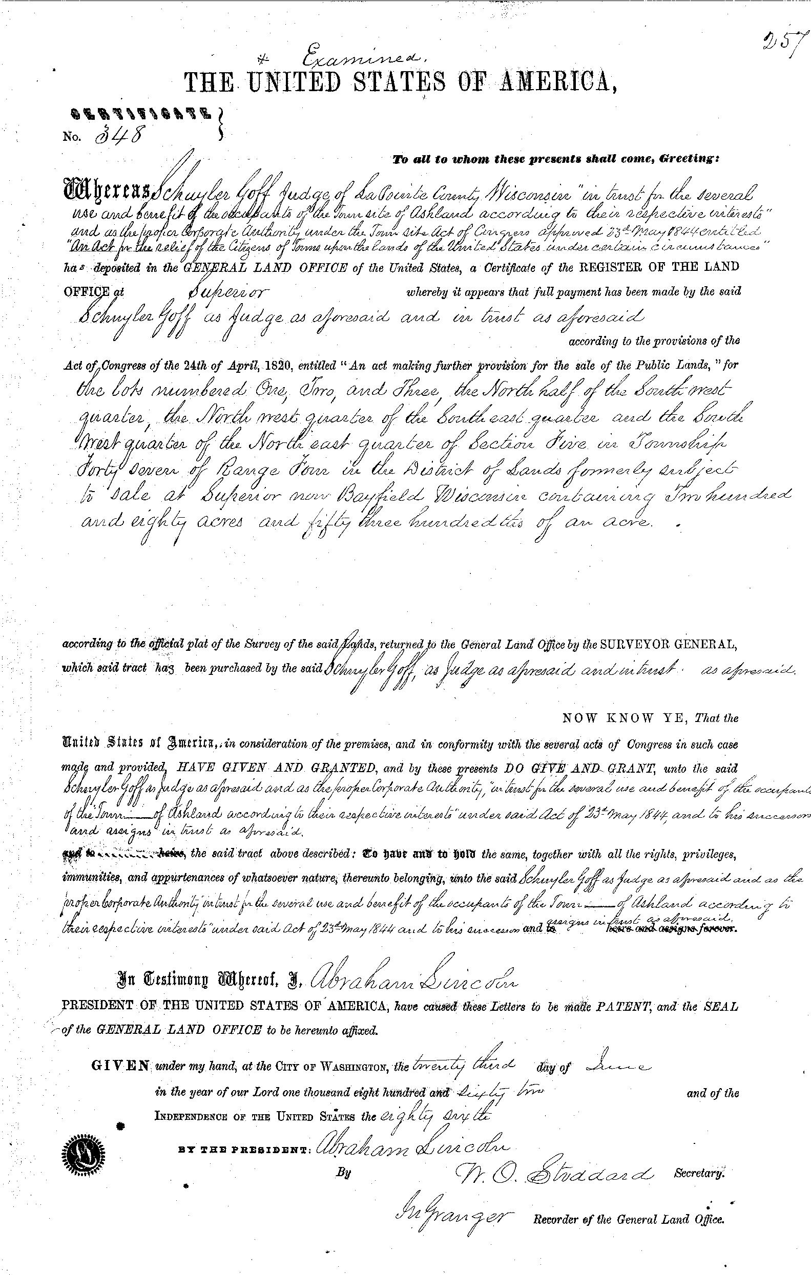
Land patent for the town site of Ashland issued by President Abraham Lincoln on June 23rd, 1862 to Schuyler Goff:
“The contract between the three was, that Mr. Whittlesey and Mr. Kilborn were to receive each an eighth interest in the land, while the residue was to go to Mr. Beaser. The patent for the land was issued to Schuyler Goff, as county Judge of La Pointe county, Wisconsin, who was the trustee for the three men, under the law then governing the location of town sites.”
~ Biographic sketch of Martin Beaser
OF THE OPENING OF ROADS IN THE EARLY DAYS OF ASHLAND.
In reporting upon this subject it is very possible that our town authorities of the present day may be put somewhat to the blush by the manner in which these and other like improvements were made. And I will guarantee the re-election of any Town Board, or other town officer who will carry out the program of former days for the opening of roads, which was simply this:
Whenever a road was needed such men as Edwin Elllis, Martin Beaser, George Kilbourn and myself, (I came near overlooking the latter,) and others who mainly volunteered their work, shouldered their axes and served in person until roads contemplated were completed. There was also this peculiarity attached to this class of individuals; they did not hang about the steps of the town house the balance of the year for the purpose of getting bills audited for work done upon the highways. It was in this manner that the road leading to Odanah and also that leading south to White River Falls were first opened. Even Indians partook of the same spirit in volunteering their labor, as Aid-de-camp to their Great Leader, Rev. L. H. Wheeler.
I have no doubt Dr. Ellis still bears in mind how the woods at Bear Trap were made to echo the yells of the Indians as they collided with the party from Ashland on the very day agreed upon, and I think I may safely say that the citizens of Odanah and of Ashland looked upon the opening of this road as a momentous event, and one which cemented us together even more firmly as friends and neighbors, though I have no doubt many of my readers will stand ready to declare that the foot race existed not very far back.
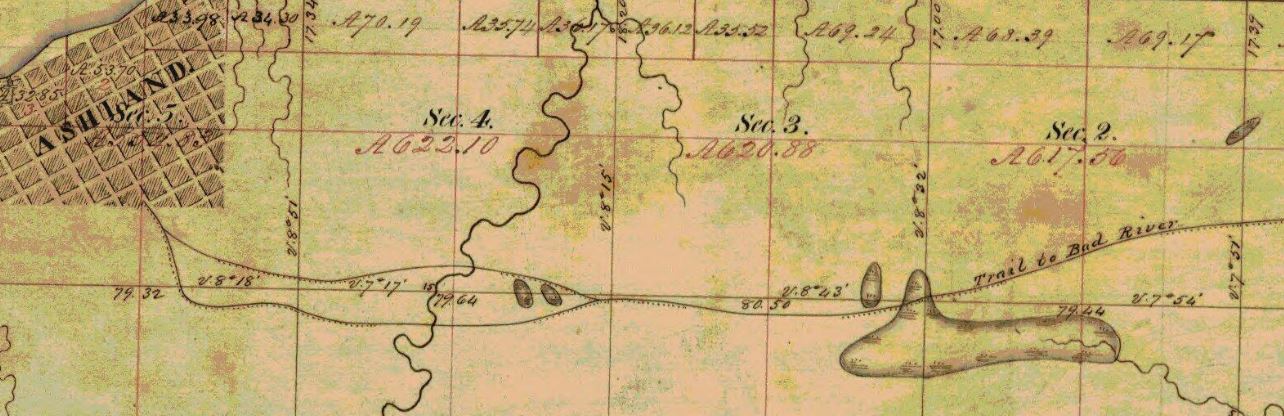
Detail of trail from Ashland to Bad River on Barbers’ survey during the Summer of 1855.
We wore good countenances, slept well nights, and paid one hundred cents on the dollar of our obligations. We were not ashamed to eat salt pork (those of us who could get it,) while our faithful wives vied with each other in the different styles of cooking this staple article of diet.
Next to this comes the everlasting pancake, without which neither town site nor pre-emptions could be legally established.
~ History of the Soo Line by James Lyden, chapter 9.
~ History of Northern Wisconsin by the Western Historical Company, 1881, page 82.
On the second day of June, 1877, I had the honor of driving the last spike, which took place at Chippewa Station, amid the shoutings of a large assemblage of people, including laborers upon the road, and in a few moments thereafter the first train from Milwaukee passed over the road on its way to Ashland, amid great rejoicing and demonstrations of joy over the victory won. At Ashland also the excitement became intense and though it was late on a Saturday evening on which our train reached the town, the illumination of the place brought to our view a field of faces, crazy with excitement over the event they were celebration. As for myself, I confess I felt very much like saying, “Now let thy servant depart in peace.” No longer were we to be informed of what was to be done, but we now knew it to be actually accomplished, and the Wisconsin Central Railroad remained a standing monument to the good name of Gardner Colby, Charles L. Colby and E. B. Phillips, all other efforts being secondary to that of these individuals. I have in my possession a map of this section of country, published by Charles C. Tucker in 1858, on which he laid down an imaginary line of railroad as being likely to be constructed from Madison via Portage and Stevens Point to Ashland, and strange to say it lays down the precise route of the Wisconsin Central Railroad, the very first to be constructed.
Having received by our last mail an important official statement from the Railroad Commissioner for the State of Wisconsin, I will insert the same here rather than to fail to have it published:
He says “the number of miles of railroad now constructed within the State of Wisconsin is two thousand six hundred and fifty-nine and 6-100, while there are seventy-one thousand seven hundred and fifty-nine miles of railroad now operated within the United States, with a capital and debt amounting to four billion six hundred and fifty-eight million two hundred and eight thousand six hundred and thirty dollars.”
STATISTICS IN GENERAL

In furnishing these I desire specially to acknowledge the obligation I am under to Mrs. James Wilson, for granting me access to early records of the place kept by Martin Beaser, Esq., though I find some discrepancies between his record and my own, which I think can be explained by the fact that he did not commence his record until some years after the first settlement of the place, and made it from memory along. For instance he says “the town site of Ashland was located by Martin Beaser, Asaph Whittlesey and George Kilbourn in August, 1854,” whereas Mr. Kilbourn and myself commenced the settlement of the town site July 5th, while Mr. Beaser first visited the place in August when he became an owner therein, the town site being from this time forward owned three fourths by Martin Beaser and one eighth each Kilbourn and Whittlesey.
Again Mr. Beaser’s record states that “the first house was built by Asaph Whittlesey in October, 1854, and was twenty by thirty feet square,” while the fact is I had erected two cabins upon the town site previous to the erection of this one and had lived in them.
Following cabin built by Kilbourn and Whittlesey, foundation laid July 5th, 1854, was twelve by fourteen feet square and was erected on lot number two in block one hundred and five. The foundation to the second cabin built was laid by Kilbourn and Whittlesey Sept. 9th 1854. This cabin was thirteen by fifteen feet square and was erected on lot five of block six. The outline of this building may still be traced. – The third house erected was that erected by Asaph Whittlesey on lot six in block six and was twenty by thirty feet square and this building constituted the residence of the Whittlesey family until the fall of 1857 when I removed to what is known as the Tompkins house on lots five and six in block three. I have in my possession very correct sketches of the first three cabins built, which I hope eventually to have lithographed for preservation. The fourth house was erected by Conrad Goeltz. The fifth house by Martin Beaser. The sixth house by Myron Tompkins. The seventh house by Lawrence Farley. The eighth house by Charles Malmet. The ninth house by Anthony Fisher. The tenth house by Frederick Bauman. Beyond this I am unable to give the order in which buildings were erected.
Conrad and Adam Goeltz first arrived at Ashland in March, 1855, and were employed by me in chopping and delivering cord wood upon the bay shore. As we were without a team we improvised one by harnessing these two Dutchmen and myself in the form of a spike team to a large sized hand-sled with which we banked twenty cords of wood per day.
P.S. – Adam had it twenty-two cords per day, but I think we had better throw off the two cords and try to save our reputation for veracity.
The first chickens brought into town were those brought by A. Whittlesey from Ohio in 1854.
John Beck butchered the first hogs in town, though he left a few which he did not butcher.
Martin Beaser brought the first yoke of oxen, and in 1855 raised about two hundred bushels of potatoes upon the town site. On the third of December, 1855, the schooner Algonquin landed at Ashland two hundred and twenty-five barrels of freight, seventy-five thousand feet of lumber and a yoke of oxen.
Ashland Bay froze over Dec. 7th, 1855. The two first steamboat docks were built during the winter of 1855-6, one by Martin Beaser at the foot of Main Street and one by the Bay City Company. These were carried away by the ice May 1st, 1856.
To be continued in Number VII…
1855 Inquest on the Body of Louis Gurnoe
April 11, 2019
By Amorin Mello
The following is a set of three articles collected and edited from the Superior Chronicle newspaper, followed by my personal thoughts on this matter :

Superior Chronicle newspaper July 7th, 1855, page 2.
Lake News.
We find in the Lake Superior Journal the following paragraphs of lake news:

“The brig Columbia, which carried the first cargo of ore through the Sault Ste. Marie Canal.”
~ The Honorable Peter White, by Ralph D. Williams, 1907, Chapter XIV.
Johnson & Tisdale, of Cleveland, have just built a small side-wheel steamer, for J. H. Garrett, of Ontonagon, and intended to be used on that river as a passenger boat, and also for towing between the mouth of the river and the mines. Her dimensions are : length of keel, 85 feet; beam, 14 feet; depth of hold, 2 feet. She has two engines, and will draw about fifteen inches water.
The Garrison stable at the Sault Ste. Marie, containing two horses was set on fire on the morning of the 29th ult., and, with its contents, totally consumed.
The Canal Company showed their patriotism on the Fourth of July, by exploding about one hundred and fifty barrels of damaged powder.
The first locomotive for the Iron Mountain Railroad, from Lake Superior to the Iron Mountains, left Buffalo on Tuesday by the brig Columbia, for Marquette.
Superior Chronicle newspaper, October 23rd, 1855, page 2.
Man Shot.

George Riley Stuntz
Deputy U.S. Surveyor, and Chequamegon Bay land and minerals speculator.
On Tuesday night last an affray occurred on Minnesota Point, which resulted in the shooting of a sailor, attached to the brig Columbia. The vessel was lying at the wharf of Messrs. Stuntz & Co., and the crew, under the influence of liquor, went on shore for the purpose of having a frolic; in the course of their spree they came across some Indians, encamped on the Point, and one of the men soon provoked a quarrel with an Indian. The Indian was being beaten severely, when the captain coming up, interfered, whereupon he was attached by the man. The captain, being small in statue, and unable otherwise to defend himself, drew a pistol and fired at his assailant, the ball entering his side. The wounded man was brought to town, his wound dressed, and is now said to be doing well, the ball not having penetrated to any serious depth.
Superior Chronicle newspaper, November 6th, 1855, page 2.
Death of Louis Gurnoe — Inquest by a Coronors’ Jury — Verdict, etc.
There were more than one Chippewa mixed-blood named Louis Gurnoe.
man living alone in Superior City during the 1855 Wisconsin Census. No further sources about J. Baker could be found.
Several weeks ago we gave an account of the shooting of a half-breed named Louis Gurnoe by Captain Wells, of the brig Columbia. The affray occurred on Minnesota Point, opposite Superior. It appears that Gurnoe was a man of very intemperate habits, and several nights previous to his difficulty with the captain, was engaged in a row at a low groggery on First street, kept by a negro named Baker. A dance was being held at that place, and Gurnoe, under the influence of liquor, challenged those present to a fight; he was then set upon, knocked down, and kicked and beaten in a cruel manner. The injuries he sustained, aided by excessive dissipation, ensued his death, just as the vessel was leaving our port. At La Pointe, a coronor’s inquest was held on the body, and the verdict rendered was that death was caused by bruises received at Baker’s house. We hope this matter will be brought before the grand jury at the next sitting of our circuit court, and while we may not expect to see the murderers brought to justice, we hope, at least, that sufficient cause may be shown why this miserable den should be removed. It has been tolerated too long already, and for the good order and character of our town, if for no other consideration, some effect should be made to put a stop to the disgraceful proceedings there enacted.
We publish the entire testimony elicited at the inquest, verdict of the jury, and an affidavit made by Gurnoe previous to his death, exhonorating Captain Wells from all blame whatsoever.
Joseph Stone, one of the hands on board, being duly sworn said:
That on Tuesday evening last, the brig Columbia, Captain Justus Wells, from St. Clair, was opposite Superior; there was a noise between [Sandy?] and deceased, Louis Gurnoe; Louis wanted to fight; captain wished him to stop; deceased knocked captain down; Louis then challenged captain to fight; he then got hold of the captain by the hair of the head; captain told him several times to let go; captain said if he did not let go he would shoot him; told him five or six times to let him go; he did not let go; the first thing I heard was the report of a pistol; [Sandy?], captain, and myself carried him to a tent; I stopped there till four o’clock; captain directly sent two men away to get a physician; deceased was in liquor at the time; he had been very quarrelsome; he shipped at Saut Ste. Marie this trip; he had been bruised on the face the Saturday previous; on the Monday previous when leaving Superior wharf he was so intoxicated that he fell off the provision chest; he was sick coming up; he was unable to do duty after Saturday.
Simeon Nelsonn being duly sworn said:
We went on shore at Superior, on Saturday evening last; at Baker’s there was a dance; the dance went on nicely till about twelve o’clock; Louis said something to the effect that no one in the room was able to fight him; with that a little Irishman took it up; I went in and hauled Louis back; some one took me off from him, shoved me on one side and commenced at Louis; knocked him down with his fist, and several men piled on him; they then commenced kicking him in the side, breast, and once or twice in the face; after a while they were parted; then Louis commenced drinking again – had been drinking during the evening. After having got all pacified we went on board about two o’clock in the morning; he went to sleep; when he woke he swore he would have a row with somebody before he left the place; on going on shore he commenced drinking; we unloaded the vessel on Monday and Tuesday, and on that afternoon we went over to Minnesota Point; in the evening all went ashore to have some sport; Louis said, before he went ashore, he was bound to have a row with the captain; after going on shore, everything went on well till about two o’clock in the morning. (Wednesday;) I was lying in the lodge; Louis came in and commenced at me; I told him that I did not want any fuss with him and that everything he said I was bound to knock under to save a row; at that the captain heard the words from Louis and came out from another lodge; as Louis was going to come in at me, the captain grabbed him by the shoulders, hauled him back, and said to him, “Louis we did not come here for a row, we came to have sport;” Louis turned on him, and knocked him down; they were then parted; the captain balloed “enough;” Louis was going at him again; the captain stepped back, pulled out a revolver, and said, “If you don’t leave me alone I will shoot you;” Louis opened his breast to him, and said, “Here’s a clean breast shoot;” captain stepped back, and Louis went at him again; caught the captain by the hair of the head; captain told him if he did not let go he would shoot him; we tried to part them again; couldn’t part them; captain wanted to let go, but Louis wouldn’t; captain again said “If you do not let go I will shoot you;” as Louis was drawing back his foot to kick the captain in the face, he being down about knee high, the captain again repeated his caution, gave him one minute to let go, and then shot him; Louis then let go; says he, “I’m dead’ I’m dead.” – Captain said “I thought it would turn out that way – I told you I would shoot but you would not mind me;” captain said “If there is anything I can do I will do it;” the captain, Joseph Stone and myself, carried him into the lodge; the other two boys that were with him commenced dressing his wounds; captain sent John Scott and myself aboard the vessel after the boat to go for a physician; we went aboard and got the boat; got the second mate and Benj. Rassau to go for the doctor; went to Superior; couldn’t find a physician; captain, second mate, Joseph Chapman, a Frenchman living on the point, and myself, got the deceased into the boat and brought him aboard; before we got him aboard a physician came; about eight o’clock in the morning I saw deceased lying in the cabin; said he felt better; about four o’clock p.m. we endeavored to put him into one of the berths; he seemed to be in convulsions; on Wednesday night he got out of his berth, went on deck, and walked fore and aft; Thursday morning he left the cabin and sat on the rail aft; I said “Louis, you will be falling overboard;” he said “there is no fear of that;” he then left the rail; I was standing at the helm; he came up; looked me very hard in the face; I said, “what is the matter?” he gave no answer, but went directly into the boat; deceased had been very quarrelsome all the way up; he remained in the boat about three minutes; he was sitting in the boat with his arm on the taffrail; I took him to be asleep, and tried to wake up; I lifted his arm up, and eased him down into the boat to keep him from falling overboard, and went down after a lantern, (about five o’clock a.m.;) before I had time to time to come with a lantern, some one hard me talking to him and was there before me with one; the captain was also there; I looked at him, and said he was dead; then we took him out of the boat, and laid him forward of the cabin, and put a mattress under him; he was warm at the time, and we thought he might recover; one of the passengers then said life was not gone but he was dying; deceased frequently complained of his bruises received on Saturday night.

James Chapman
~ Madeline Island Museum
James Chapman, being duly sworn, said:
The quarrel commenced about a squaw; in other respect; he corroborated the testimony of the previous witness.
Daniel Weihl, a passenger, being duly sworn, said:
I saw the doctor probe the wound, and he followed the rib, one or one and a half inches; I turned away as he found the ball; I do not think the wound was sufficient to cause his death; no inflamation existed; deceased went forward so many times that I concluded he had the diarrhea.
A. W. [Groveract?], being sworn, said:
I told the captain not to use the weapon there; after the shot, saw the deceased standing by a tree; he vomited blood; had not seen deceased vomit blood previous to the shot; he bled very near a pint; the blood from the bruise on his face might have got into his mouth and he threw it up.
John [Babner?], being sworn, said:
I corroborate the testimony given by Mr. Nelsonn.
Mr. Hancock, (a passenger,) being sworn, said:
I corroborate the testimony given by Mr. Nelsonn.
Calvin Ripley, being sworn, said:
Deceased had been sick about six weeks previous to his shipping, and was sick again when about two days out; was drunk every night, while at Superior, that I saw him; kept the forecastle a day after the fight at Superior; doctor said the wound would not injure him at all – that deceased was worse off in other respects; doctor said it was better for deceased to be on shore; he might suffer from the bruises; deceased wished to come on board and go down.
E. M. Raymond, being duly sworn, said:
I saw the doctor drawing the ball out, and left; saw nothing out of the way till last evening; noticed that deceased thrashed about the chains, and made unnecessary noise; I think deceased was not in his right mind last evening.
Daniel Weihl, being recalled, said:
The wound did not cause mortification; the worst bruise is the one at the rim of the belly; have seen a person kicked in the same place vomit about a quart of blood.
J. E. Rogers, (passenger,) being sworn, said:
That he observed that that deceased, during the time he lay in the cabin, hawked and spit, and about one-third of it appeared to be blood and the rest yellowish matter.
At the conclusion of the testimony, the following verdict was rendered by the jury:
An inquisition taken on board the brig Columbia, Captain Justus Wells, in the port of La Pointe, on the 18th day of October, 1855, before John W. Bell, one of the justices of the peace for La Pointe county, Wisconsin, upon the view of the body of Louis Gurnoe, there dead, by the jurors whose names are hereunto subscribed, who being duly sworn to inquire on behalf of the people of this State, where, in what manner, and by what means the said Louis Gurnoe came to his death, upon their oaths do say:
That the deceased came to his death in consequence of bruises received at Superior, at Baker’s residence, from the hands of individuals to the jury unknown, but with whom he was engaged in a fight;
That he was at the same time, and had been, suffering from the effects of continued hard drinking, following sickness, from which he had only partially recovered previous to shipping;
That we acquit Captain Wells of all guilt as to the shot fired by him, and that we do not deem it as a mortal wound, or one that accelerated the death of the deceased.
In witness whereof, the said Justice of the peace and the jurors of this inquest have hereunto set their hands the day and year aforesaid.
JOHN W. BELL Justice of Peace,
S. S. VAUGHN, Foreman,
M. H. MENDELBAUM,
R. D. BOYD,
JOHN M. BRADFORT,
JULIUS AUSTRIAN,
A. CARPENTIER.
Copy of a settlement made at Minnesota Point for assault and battery:
Minnesota Territory, Superior county,
Dock at Minnesota Point,
October 17, 1855.Know all men by these presents, That whereas the brig Columbia, of one hundred and seventy-six tons, commanded by Capt. Justus Wells, from St. Clair, Michigan, District of Detroit, laying at Minnesota Point now and for a few days previous, and among other hands on board said brig was one Louis Gurnoe, a half-breed, and this man was in a state of intoxication, and was making a quarrel with other parties; and whereas, the said captain interfered for the purpose of introducing peace measures, and the said Gurnoe opposed the said captain, and they came to blows and a clinch; and whereas Gurnoe held the said captain firm by the hair of the head, and the said captain requested the said Gurnoe to let go of him, and he would not, and the said captain shot the said Gurnoe in the skin of the side to get clear of him, which would was only a flesh wound, entering the skin against the rib and running along under the skin outside of the rib; and the said captain sent a boat to Superior City for a doctor, and he came and dressed the said wound, and said captain paid said doctor five dollars for his fee for crossing St. Louis river from Wisconsin; and the said Louis Gurnoe having [diver?] other fights, was badly bruised before this; and whereas the said captain has made arrangements in Superior City for the taking care of said Gurnoe to the amount of twenty-five dollars, which we receive of the said Captain Justus Wells, and discharge him of all expense whatever that may arise in an action of assault and battery or any other action for the said causes as the said Gurnoe has received a full compensation for all injuries by the said captain on the ground that the said captain seems not to have done anything more than to defend him or his own personal safety, and what he gives is of good heart and a charitable act received by me.
This settlement is to be construed no further than the said parties have a right by law to settle actions and causes of action. In this settlement the said captain does not mean to have it understood that he acknowledged that he has done anything or [ac?] whereby he may be liable to the law, but for the purpose to buy his peace and a general good will to the said Gurnoe.
(Signed)
LOUIS (his X mark) GURNOE,
In presence of JOSEPH GURNOE,
[DORUS MARCUS?], and CALVIN RIPLEY.
Amorin’s Commentary
Hi, Amorin here again. I don’t always add commentary to my reproductions of Chequamegon History, but when I do… it is because I am still trying to understand the rest of the story.
First and foremost, the death of Louis Gurnoe was horrific. It is unfortunate that these articles disrespected him and served him no justice. The October article doesn’t even mention his name. The only real biographical information gleaned from the November article about Louis Gurnoe is that he was a Chippewa mixed-blood who came aboard the brig Columbia at Sault Ste. Marie. Apparently, his death was far more newsworthy than his life to Americans.
The language stereotyping Louis as a drunk Indian is disgraceful, and makes me question whether the references to the negro and little Irishman were perjury. To be clear, yes, I do believe this entire inquest was a fraud. One red flag, for example, is that the doctor was never identified by any of the witnesses for verification.
Besides dishonoring Louis’ life, it seems that the sole purpose of the Verdict in the November article was to acquit George Riley Stuntz and Captain Justus O. Wells of any guilt with the incident as reported in the October article. The Judge and Jury of the mystery Louis were all white Euroamerican settlers of La Pointe that were very involved with Lake Superior Chippewa mixed-bloods by marriage and/or business, yet there does not seem to be any amount of empathy expressed by them for Louis Gurnoe.
Although these articles dishonored Louis (and failed to identify exactly which Louis Gurnoe he was) they revealed just enough information to hint at what his life may have been like before boarding the brig Columbia at Sault Ste. Marie in 1855. The Gurnoe/Garneau/Gournon/Gornow/Gaunaux/etc. families of Chippewa mixed-bloods (a.k.a. Metis) were very active in the cosmopolitan politics of Lake Superior throughout the mid-1800’s. There is more than one Louis Gurnoe this could have been, so unfortunately the Louis Gurnoe that boarded the brig in 1855 may only be known as a mystery to Chequamegon History.
Consider, for example, the Louis Genereaux [Gurnoe] that authored an August 29, 1855 letter to Indian Affairs Commissioner George W. Manypenny via the Mackinac Indian Agency on behalf of Saginaw Chippewa/Odawa Tribe trying to locate their reservation lands in lower Michigan. While it may have been possible for someone to travel from lower Michigan to western Lake Superior within this time frame, there doesn’t seem to be any compelling correlation suggesting that this Louis Genereaux would be the same Louis Gurnoe from the brig Columbia.
Another example Louis Gurnoe that we may consider is the one featured in the bottom right of the following photograph from 1855 at Sault Ste. Marie;
the elder Louis Gurnoe.
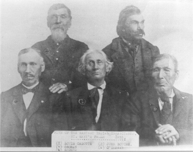
1855 photograph from the Soo Evening newspaper labeled “Five of the Earliest Indian Inhabitants of St. Mary’s Falls” [Sault Ste. Marie] and identified from left to right:
1) Louis Cadotte; 2) John Bouche; 3) Obogan; 4) O’Shawn;
5) [Louis] Gurnoe.
Read Metis-History.info/ by Richard Garneau (Gurnoe) for other possible identities of the first four men in this photograph.
It is possible that the Louis Gurnoe from these articles was one of this elder Louis Gurnoe’s sons. Louis Gurnoe’s Settlement at the end of the November article was signed by another son, who is featured in the bottom center of the following photograph:
the Indian Agency interpreter Joseph D. Gurnoe.

Top: Frank Roy, Vincent Roy, E. Roussin, Old Frank D.o., Bottom: Peter Roy, Jos. Gourneau [Joseph Gurnoe], D. Geo. Morrison. The photo is labelled “Chippewa Treaty in Washington” and dated 1845 by the St. Louis Hist. Lib and Douglas County Museum, but also dated 1855 by the Northeast Minnesota Historical Center. It was probably taken during the Bois Forte Treaty of 1866, which was these men acted as conductors and interpreters in Washington, D.C. Photograph digitized by Mary E. Carlson for her book The Sawmill Community at Roy’s Point.

Superior Chronicle newspaper November 4, 1856
I will share details about Joseph D. Gurnoe’s life, and his professional relationship to James Chapman, but these details will have to wait to be published in another post in the future. This concludes my thoughts for this post.
Until next time,
Amorin
After Missing Treasure
April 10, 2019
By Amorin Mello
The New York Times
June 15, 1897
AFTER MISSING TREASURE
—
James Arthur Looking for $35,000 Buried in Wisconsin at the Outbreak of the War.
—
GOLD HIDDEN IN THE GROUND
—
Net Assets of a Wisconsin Bank Closed When Arthur Enlisted in the Army – Put Away by His Partner, Ell Pingers.
—
SUPERIOR, Wis., June 14. – James Arthur, a veteran of the civil war, now a resident of Buffalo, N. Y., arrived in Superior a few days ago to make inquiries concerning a transaction dating back nearly forty years, and to complete arrangements for starting on a mission in quest of a treasure supposed to be sunk in the bowels of the earth at a point not far from the town of La Pointe, in Ashland County, Wis.
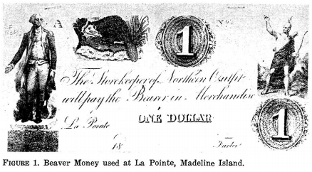
La Pointe Beaver Dollar
Northern Outfit, American Fur Company
~ Wisconsin Academy of Science, Arts, & Letters, Volume 54, page 159.
According to Mr. Arthur’s story, a bag containing $35,000 in gold was buried in the ground by Ell Pingers in 1861, and has never been discovered, though several expeditions have gone in search of it. It is a strange story, but it is not fiction, unless several old timers with records for veracity have combined to deceive the world, and unless State records lie and other documents fail to prove genuine. The money was certainly placed in a hole in the ground by Ell Pingers in the year 1861, and it probably was never taken away, for the man who did the planting was killed during the war, and no other person knew where the hiding place was. A paper has come to light recently which furnishes a clue to the location of the treasure, and Mr. Arthur expects to be richer by $35,000 within a fortnight.
Superior Chronicle – November 4, 1856
“INDIAN PAYMENT. – Mr. Jos. Gurnoe, last week, distributed among the Chippewa Indians of this vicinity their annuities. An unlimited number of silver half dollars are now in circulation, and all are enjoying the benefits of Uncle Sam’s liberality.”
In the year 1856, when wildcat money flooded the State of Wisconsin, and when the country was on the verge of a financial and political crisis, James Arthur and Ell Pingers, two young men who had been supplied by their respective fathers with a good start in life, immigrated from New York to La Pointe and established a bank, which not only issued notes of its own, but made a specialty of discounting the issue of other banks throughout the State. They pulled through the panic of 1857, and the bank was counted among those that redeemed its currency at face value. When war became imminent between the North and South the young men decided to close out their banking business and return to the East to engage in something more lucrative. In 1861, however, before the bank closed, James Arthur made a trip to Milwaukee, and there became fired with a desire to serve his country as a soldier. He sent a letter to Pingers at La Pointe asking him to close out the business as soon as possible and leave for the East with all the funds. He also gave Pinger the number of his regiment and full directions as to where letters should be sent. Then he marched to the front with a Wisconsin regiment.

Facsimile of a $50 coin found at La Pointe.
~ Joel Allen Barber Papers, Summer of 1858
Six months after joining the army Arthur received his first and only communication from Pingers. It was a short note, dated from Milwaukee three months prior, and had been forwarded from post to post until it finally reached him at St. Louis. This note is now in the possession of Mr. Arthur, and was shown by him on his arrival here several days ago. It reads as follows:
“Milwaukee, June 8, ’61 – 4 P.M.
“Friend Jim: Got your letter all right. Have closed up bank and sold everything for cash. I realized in all $37,000, and take $2,000 of that with me, but not caring to take a large sum through such a wild country I buried it in a safe place and will advise later concerning exact spot. I am off for bloody war myself. Yours,
“ELL PINGERS.”
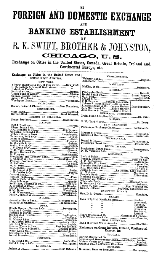
Julius Austrian operated a bank at La Pointe circa 1855.
In 1863 Arthur went on a furlough to visit his mother and sisters in New York City, and while there learned that Pingers had been killed at the battle of Richmond, Ky., on Aug. 30, 1862. The papers and numerous personal effects of the dead soldier had been shipped to his mother from Milwaukee previous to his enlistment in the army, but a thorough search failed to disclose any information concerning the location of the hidden treasure. So the furloughed soldier returned to the scenes of war without hope of ever being able to recover the snug little fortune stored away somewhere in Wisconsin soil.
The war over Mr. Arthur returned to New York, and in 1866 he made a trip to La Pointe in company with two friends for the purpose of hunting up the hidden gold. The mission was a fruitless one, but it had the effect of exciting the La Pointe community, and for years after that the natives dug holes in all directions from the old bank, but as far as known the treasure was never unearthed.
In 1867 Arthur’s mother died, leaving him a small fortune, and the following year he married the sister of the dead soldier, Ell Pingers. Through this marriage all the personal effects of Pingers came into Arthur’s possession, and he made many searches through the papers for a clue to the whereabouts of the missing $35,000, but without result. Ten years after his marriage he made another trip to the scene of his old banking operations, and five years after that he sent a trustworthy employee to look for the hidden gold, but no gold was to be found, and finally all hope of ever recovering the treasure was abandoned.

Hermit Island is believed by some to contain several other long-lost treasures:
– 1861 Wilson the Hermit
– 1760’s British Military Payroll
– Stereotypical Pirate Stories
Did Pingers bury their treasure here as well?
About three weeks ago, while turning the pages of an old book which had once been the property of Ell Pingers, a small piece of note paper was found by Mrs. Arthur which contained a memorandum written by the dead soldier and which gave the missing information for which search had been made for years. This note, Mr. Arthur claims, will no doubt lead to the discovery of the treasure in time, but the references it makes to roads, trees, and other landmarks have long since been removed by the hand of progress or obliterated by time, and the undertaking will therefore be attended by more or less of the difficulties before experienced. The old gentleman is confident that, with the information obtained from old acquaintances here and the assistance expected from old residenters at La Pointe, he will be able to unearth the long-buried treasure. He declares his intention of donating one-half of the $35,000 to the veteran soldiers of the Union Army and turning the remainder over to his wife to do as she pleases with.
By Leo
If you haven’t seen a lot of posts lately, it’s because I’ve given up the the lucrative history-blogging business to become a mad scientist. I have a time machine that will make me wealthy beyond belief. Unfortunately, there are still some kinks to work out with the time-space continuum. Until they’re fixed, I plan to fund my research with my state-of-the-art genetic-ancestry testing business, 1823andMe™. Just spit into a tube, and in three to four weeks we can tell you, with scientific precision, what your actual true race and ethnicity are. You thought you were English? Ha Ha–you’re actually Scottish!
I had hoped to be collecting modern spit by now, but my stupid investors were frightened off by a simple trademark lawsuit. This has really slowed the field testing, so I’ve been reduced to taking the time machine back to eras where I can get saliva on the cheap. In fact, I just returned from a trip to the Lake Superior country!
Originally, I was just going to visit Sault Ste. Marie in 1830, but on the ride back, I just had to stop in at La Pointe in 1850 and 1855. I mean, I used to write a lot about that place and time, so it seemed only right to collect some stories and anecdotes for old-time’s sake.
But, disaster! My briefcase spilled out all over the floor and the notecards got all jumbled. The genetic profiles of the seven donors, and their descriptions, are all out of order. Can you help me sort them?
Here are the seven genetic ancestry profiles I collected according to my proprietary SuperDNA™analysis system:
- 100% Native American
- 88% Native American, 12% European (Mediterranean)
- 50% Native American, 50% West African
- 50% European (British Isles), 50% Native American
- 100% European (Mediterranean)
- 75% Native American, 25% European (Mediterranean)
- 100% European (British Isles)
And here are the descriptions of the seven people they belong to:
- I met him talking to a group of American pioneers who were planning to settle in the new city of Superior. Being one of the few English speakers around, he informed them that he was the first white man born in the area where the city was being built.
- He was a young man of the Lac Vieux Desert band. He arrived at La Pointe in his bark canoe for the payment and Midewiwin ceremonies. We tried to talk a little, but he only spoke Ojibwe.
- This kindly old woman was the matriarch of the leading family on the island. The federal census taker was in the middle of getting her information. I asked if he was going over to Bad River next, and he said he didn’t need to because he only had to count white people.
- We talked for quite a while because there were so few people who spoke English around. He was a clerk and he told me about how he “trades with the Indians,” but now his boss wants him to go into politics. His boss is a prominent Democrat who is friends with John Calhoun and all the other pro-slavery politicians.
- His name was Shaw-shaw-wa-ne-ba-se of the Snake clan, and you could tell he’d led a rough life out in the prairies of Manitoba. He had stolen horses from the Mandan around the time Lewis and Clark stayed with them. Later, his family considered joining Tenskwatawa and Tecumseh in their prophecy to give up white ways so the Great Spirit would send the whites back across the ocean.
- This old Frenchman was loved by almost everyone around. He took great pride in being descended from the French nobility and saw himself as a link back to the old French days at La Pointe. He was proud of his role in getting the Catholic church re-established on the island.
- He was one of the most imposing and respected Ojibwe chiefs around. He was great at playing the American and British authorities off each other. He did the same with the churches, and his influence on other Ojibwe bands was impressive.
Can you sort them accurately?
Ack! Absent-minded professor here–I forgot I had already compiled those notes with names and a few pictures. Sorry for wasting your time. Here are the actual results:
 I met him talking with a group of American pioneers who were planning to settle in the new city of Superior. Being one of the few English speakers around, he informed them that he was the first white man born in the area where the city was being built. I met him talking with a group of American pioneers who were planning to settle in the new city of Superior. Being one of the few English speakers around, he informed them that he was the first white man born in the area where the city was being built.
Bonga, Stephen 1823andMe™ SuperDNA™: 50% Native American, 50% West African |
| He was a young man of the Lac Vieux Desert band. He arrived at La Pointe with his bark canoe, for the payment and Midewiwin ceremonies. We tried to talk a little, but he only spoke Ojibwe.
Gendron, Antoine 1823andMe™ SuperDNA™: 100% European (Mediterranean) |
| This kindly old woman was the matriarch of the leading family on the island. The federal census taker was in the middle of getting her information. I asked if he was going over to Bad River next, and he said he didn’t need to because he only had to count white people.
Cadotte, Mdme. Madeleine Equaysayway 1823andMe™ SuperDNA™: 100% Native American |
 We talked for quite a while because there were so few people who spoke English around. He was a clerk and he told me about how he “trades with the Indians,” but now his boss wants him to go into politics. His boss is a prominent Democrat who is friends with John Calhoun and all the other pro-slavery politicians. We talked for quite a while because there were so few people who spoke English around. He was a clerk and he told me about how he “trades with the Indians,” but now his boss wants him to go into politics. His boss is a prominent Democrat who is friends with John Calhoun and all the other pro-slavery politicians.
Roy Jr., Vincent 1823andMe™ SuperDNA™: 75% Native American, 25% European (Mediterranean) |
 His name was Shaw-shaw-wa-ne-ba-se of the snake clan, and you could tell he’d led a rough life out in prairies of Manitoba. He had stolen horses from the Mandan around the time Lewis and Clark stayed with them. Later, his family considered joining Tenskwatawa and Tecumseh in their prophecy to give up white ways so that the Great Spirit would send the whites back across the ocean. His name was Shaw-shaw-wa-ne-ba-se of the snake clan, and you could tell he’d led a rough life out in prairies of Manitoba. He had stolen horses from the Mandan around the time Lewis and Clark stayed with them. Later, his family considered joining Tenskwatawa and Tecumseh in their prophecy to give up white ways so that the Great Spirit would send the whites back across the ocean.
Tanner, John Shawshawwanebase 1823andMe™ SuperDNA™: 100% European (British Isles) |
| This old Frenchman was loved by almost everyone around. He took great pride in being descended from the French nobility and saw himself as a link back to the old French days at La Pointe. He was proud of his role in getting the Catholic church re-established on the island.
Cadotte Jr., Michel (Mishoons) 1823andMe™ SuperDNA™: 88% Native American 12% European (Mediterranean) |
 He was one of the most imposing and respected Ojibwe chiefs I met. He was great at playing the Americans and British off of each other. He did the same with the churches, and his influence on other bands was impressive. He was one of the most imposing and respected Ojibwe chiefs I met. He was great at playing the Americans and British off of each other. He did the same with the churches, and his influence on other bands was impressive.
Shingwaukonse 1823andMe™ SuperDNA™: 50% European (British Isles) 50% Native American |
Whew! Disaster averted.

Okay, back to reality. I don’t have a time machine, I don’t have much to say about Elizabeth Warren’s campaign roll-out, and I actually had my DNA done by Ancestry.com and enjoyed the process. So, why the snarky attempt to dabble in anthropology, where I have no business dabbling?
Is it because I really am retiring from teaching* at the ripe-old age of 35 but still have a compulsion to quiz and lesson-plan?
No! It’s because I have some upcoming posts on the concepts of race, identity and citizenship in the census records from 1850-1860 and I wanted to hammer home the following points:
- We, as Americans, have been conditioned to think of race as an immutable, biological aspect of identity. However, this current form of racialized thinking did not fully take hold until the later 19th and early 20th centuries. Earlier times also had racialized thinking, but it was different.
- In the pre-Civil War Lake Superior country, one’s race had as much or more to do with his or her lifestyle, culture, religion, or assigned paternal lineage than it did with perceived genetic ancestry (i.e. amount of “blood” or DNA). Therefore, the race a person had at birth wasn’t necessarily the one he or she would have at death.
- Racial identity in the Lake Superior country was not a matter of black and white (or Native and white for that matter). There was a great deal of nuance in a person’s identity that could not be inferred simply from skin tone or facial features.
- Our modern definitions of a “white person,” a “Native person,” or a “biracial person” did not exist then.
- The idea of race as arbitrary and defined by society is not a new concept, nor is it hard to grasp on a superficial level. However, with race and racism in their current form (and the consequences thereof) being so present in our modern thinking, it is very difficult to remove our present notions from study of the past.
- I mostly like to collect old documents and create narratives. Smarter people than I can continue to fill libraries on these headier topics. That said, if we want to get a good discussion going on the census, we better get close to the same wavelength.
See you soon,
Leo
Notes:
Stephen Bonga, his father, and his brothers have figured in a number of historical studies of African-Americans in the west. See pages 7 and 43 of The Eye of the Northwest by Frank Flower (1890) for this particular story.
This description of Antoine Gendron comes directly from pages 34-37 of Kohl’s Kitch-Gami. Kohl often used pseudonyms, so “Gendron” might not be the actual name of the man he met at La Pointe in 1855.
Madeline Cadotte is an ancestor to so many of the families of this region, and such an important part of regional folklore, we sometimes lose track of Mdme. Cadotte the historical figure who lived to a very old age and was still around into the 1850s. Written sources in English, when compared to contemporaries like Chief Buffalo and Ozhaguscodaywayquay (Susan Johnston), are surprisingly sparse. There are some discrepancies in sources about her early life, but I’ve yet to encounter a source that disputes that she was born to two Ojibwe parents and raised in an Ojibwe household.
Verwyst devotes the final few pages of his biography of Father Baraga, (1900) to a short biography of Vincent Roy Jr., calling the elderly Roy “the best Indian of the Northwest.” In their younger lives, however, Roy and contemporaries like the Warren cousins, Paul and Clement Beaulieu, and Antoine Gordon self-identified variously as white, mix-blood, or Indian depending on the appropriateness of the context. This didn’t mean he wasn’t subject to discrimination, however. The land, business and political ambitions Roy and his brother-in-law, Vincent Cournoyer, were challenged by rivals on the basis of their Ojibwe ancestry.
John Tanner’s narrative (1830) is a fascinating view on the Ojibwe society of the Red River prairies at the dawn of the 19th century. He was kidnapped from American settlers at age 10 by a Saginaw Ojibwe war party. He was later adopted into a prominent Arbre Croche Ottawa family and moved with them to the prairies. By adulthood, he had forgotten English and was fully integrated into the Anishinaabe world. Though his white origins were a liability at times, he was generally perceived as an Ottawa by the Ojibwe, Cree and Assiniboine of the region. He was of the clan of the Saginaw chief who had originally taken him from his birth parents.
The marriage of Misho’s parents, Michel and Madeline, is often portrayed as the coming together of Native and European culture in the region. However, few modern-day Americans would describe Michel Cadotte Sr. as a white man if they met him on the street. His father was half Huron, and his mother was Anishinaabe from the Lake Nipissing region. Michel Jr. and his siblings had seven Native great-grandparents and one European great-grandparent. The direct paternal line being French, both Anishinaabe and French-Canadian society of the time would consider them French. This would not necessarily imply shame or rejection toward their Native ancestry, just an acknowledgement that children belonged to their father’s village.
Janet Chute’s biography of Shingwaukonse (1998), devotes significant time to his origins and how and why he fit into the Ojibwe society of the Soo rather than the area’s large Metis community.
Shameless advertisement:
*I am actually leaving the K-12 teaching field, so hopefully that will leave me with more time and mental energy for Chequamegon History. Also, let me know if you have any job openings for old-document readers and/or transcribers.
Edwin Ellis Incidents: Number V
January 16, 2019
By Amorin Mello
… continued from Number IV.
EARLY RECOLLECTIONS OF ASHLAND.
“OF WHICH I WAS A PART.”
Number V
Mr. Dear Press: – As has been already stated, the land on which Ashland now stands, had not, at the time of its first settlement, in 1854, been surveyed. The town lines had only been laying off the country into blocks six miles square.
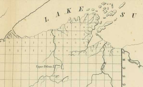
Detail from Sketch of the Public Surveys in Wisconsin and Territory of Minnesota by the Surveyor General’s Office, Dubuque, Oct. 21, 1854 as presented in Senate Executive Document No. 1, 34th Congress, 1st Session.
~ Wisconsin Historical Society
When the settlers made their claims, as most of us did, near the town lines, we were able, by the use of pocket compasses approximately to fix the boundaries of our claims. But no title could be obtained, nor even any safe foundation for a title laid, until the lands should be subdivided into sections, and the returns of that survey made to the Surveyor General’s Office, and by that officer platted or mapped, and then plats and notes sent to the General Land Office at Washington, and from there transmitted to the Local Land office. At that date the local office was at the town of Hudson, on Lake St. Croix, two hundred miles away. But early in 1855 an office was established at Superior, at the west end of the Lake, – and though this was nearly a hundred miles from Ashland, – with no roads, compelling settlers in summer to cost in open boats, and winter to walk this distance. Still it was a very great favor to settlers here, and greatly lessened their hardships, and facilitated the acquisition of their lands.
Wisconsin, Iowa and Minnesota, then were embraced in one Surveyor’s District, with the office at Dubuque, Iowa. It was the duty of the Surveyor General to provide for the details of the Government Surveys in his district, as fast as the settlement of the country might require. Gen’l Warner Lewis was then Surveyor General of this District.

Detail of Ashland City, LaPointe County, from the Barber Brother’s survey during the Joel Allen Barber Papers: Summer of 1855.

These memoirs are classic examples of Edwin Ellis, M.D. writing in the third person when crediting himself for achievements during Ashland’s early days.
No steps having been taken or any order given for the survey of the shore of Chequamegon Bay, in June 1855, Dr. Ellis left in an open boat for Superior, then on foot through the wilderness to St. Paul, following not far from the route over which many years later was constructed the Lake Superior & Mississippi R.R., – then by boat down the river to Dubuque. The situation of our affairs and the people of an early settlement here induced Gen. Lewis to order an immediate subdivision of Towns 47 and 48, North of Range 4 and 5 West, both sides of our bay, and all the lands on which squatters had settled.
Early in September of that year, (1855), Augustus H. Barber began the survey, and pushed the work rapidly, so that he had completed 47 and 48 of Range 4 in October, and the returns had been made and plats prepared and forwarded to the local land office by the first of December.
Spring of 1856
—
Last known letter from Augustus
—
“There is a conspiracy, or combination of old preemptors here who have no right to make claims. Their object is to secure each member a claim on the North shore, and to drive off and keep off by knives and pistols any who may wish to make legal preemptions on the lands they choose to appropriate to themselves.
“There may be some fighting up here this season and there is certain to be considerable laming before the business is settled. Let ‘em rip.
“I can send half a dozen to Jehanum in about as many seconds, but don’t want to do it & will avoid trouble if possible but butcher knife companies must not meddle with any claim when I have made one.“
The Pre-emptors now, for the first time, could file claims to their lands and receive assurance that they were likely to be the owners of their homes.
During December many pre-emption claims were filed, and during the closing days of the year and in the first days of 1856, quite a number proved up those claims and received duplicates, upon which patents were afterwards issued. These were the earliest titles to the present site of Ashland. Unlike many towns in the West at that period our site was not cursed with complicating claims, and it is cause for congratulations that Ashland property has no cloud upon its title and that every buyer may, with little trouble, assure himself of this fact. The title to a portion of the site of Superior was bitterly contested involving years of delay and thousands of dollars of cost and much acrimony of feeling; and it is possible that this may have had its influence in carrying the railroad to Duluth rather than to Superior. Quarrels over title are a curse to any town, especially a new one.
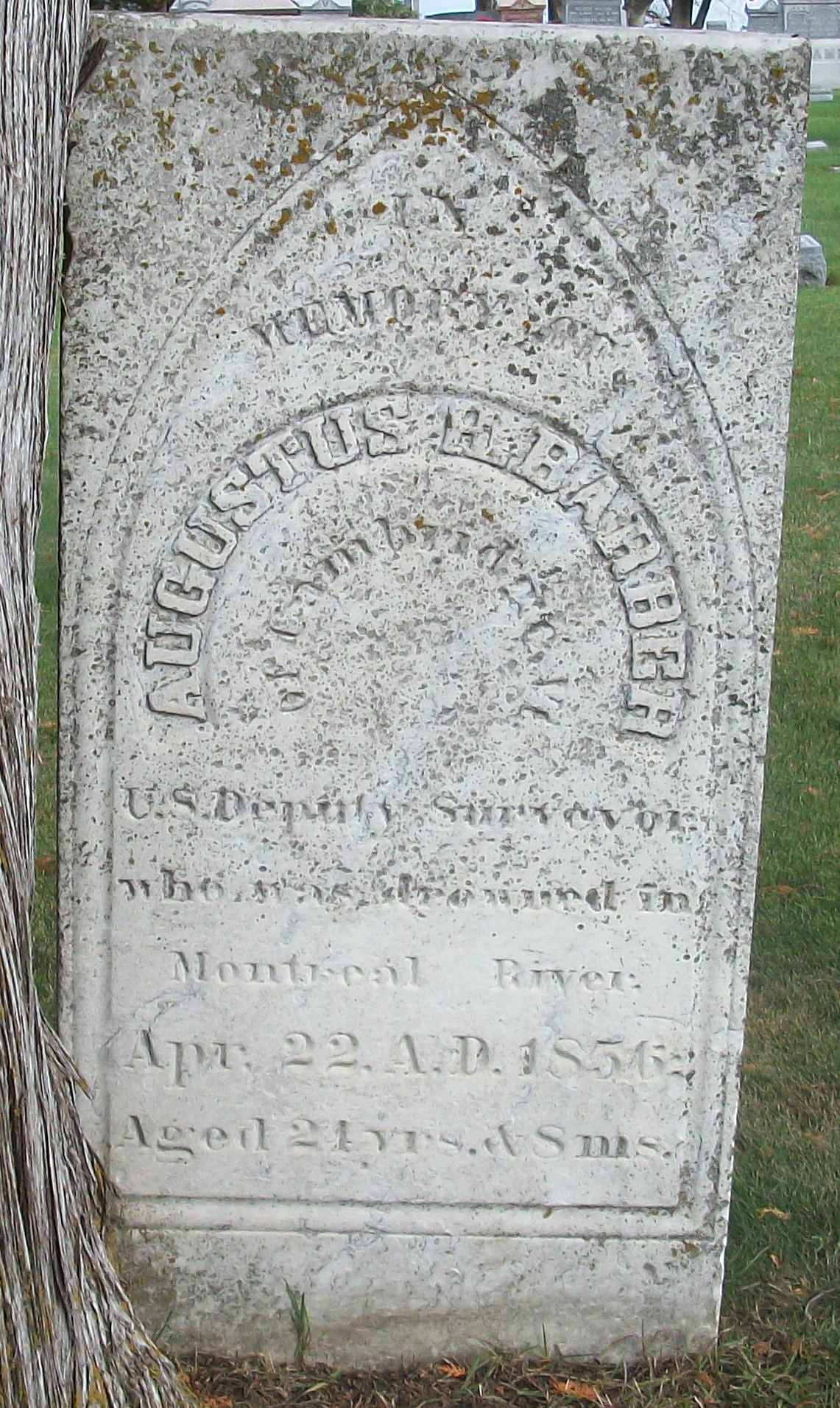
“IN MEMORY OF AUGUSTUS H. BARBER of Cambridge, Vt. U.S. Deputy Surveyor who was drowned in Montreal River
Apr. 22. A.D. 1856
Aged 24 yrs. & 8 ms.”
~ FindAGrave.com
Of Augustus Barber the early Surveyor of this vicinity, who is unknown to a larger part of this generation, a few words ought to be said:
He was a native of Vermont of an excellent family. At this time he was about 22 years of age, well educated, gentle as a Lady, refined and easy in his manners and very amiable in his temper. Like many other young men from the east, of active and enterprising habits, he had come into this outer verge of civilization to make this his home and to grow up with its institutions. He was the nephew of Hon. J. Allen Barber, of Lancaster, in this State, who once represented his District in Congress. He continued in the surveys of this part of the Lake until in the summer or fall of 1856, when he, with others, conceived of the idea of founding a city at the mouth of the Montreal River – the dividing line between Wisconsin and Michigan about thirty miles east of Ashland.
The iron range approaches nearer the Lake at that point than it does at Ashland. And though the country is much rougher and more difficult for construction of roads than between Ashland and the Range, yet the shorter route, it was argued, would more than compensate for the heavier grades. – The town was laid out and platted by Mr. Barber.
Spring of 1857
—
“This has been a sorgawful day to me, feeling more impressed with the awful calamity that befel over dear lamented Augustus and all our family in his loss One year ago to day.”
[…]
“It must remain a sealed book to us, how Augustus was hurried out of the woods, and why it was so ordained if there, was any ordination about it, till we meet him in another world, which I devoutly hope we may do though I am sorry to say more hoping than expecting.“
The Montreal, not far from its mouth, leaps down a perpendicular descent of nearly a hundred feet presenting a wild and picturesque view. Being an enthusiastic lover of the beautiful of nature and desiring to reach a position underneath the falls, Mr. Barber in a canoe with two companions, approaching too close, were drawn in by the eddying whirlpool, the canoe was capsized, and before help could reach him he and one of his boatmen were drowned. His body was recovered and was buried on a sand hillock near the mouth of the same river in whose waters he met his death. Ironton has long been deserted, and Barber’s grave with its marble headstone, is the sole make of that civilization, which twenty years ago there essayed to lay the foundation of a mart of commerce.
Summer of 1857
—
“One man working in the interest of the company the year before, had been discovered, after being missed for some weeks, dead in the forest, near the range. Bruises and other indications of violence on the body gave strong ground for the belief that he had been murdered.“
The surf of the waves of the lake in summer and fierce driving snow storms in winter, with solitude presiding over the grand orchestra, are perpetually chanting his mournful requiem, while a fond father and mother on the slopes of the distant Green Mountains are mourning bitterly the early death of their first born son.
To be continued in Number VI…
Translation Help Needed: Ojibwe and French placenames on Joseph Nicollet’s manuscript map of Wisconsin
December 31, 2018
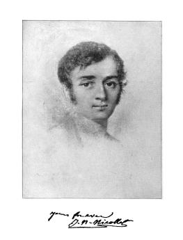
Joseph Nicholas Nicollet 1786-1843 (Wikipedia) *Not to be confused with Jean Nicolet, the explorer who visited Green Bay 200 years before this.
By Leo
Joseph Nicollet* is a name familiar to many in the Upper Midwest. The French-born geographer is remembered in numerous place names, particularly in Minnesota. For followers of Chequamegon History, though, he is best known for his 1843 Map of the Hydrographical Basin of the Upper Mississippi. The map remains very popular for its largely-accurate geography and its retention of original Ojibwe and French placenames for rivers, lakes and other land features. I’ve always found it an attractive map, and use the Chequamegon portion of it to decorate the side panels of the blog.
So, one can imagine the excitement when Brian Finstad emailed and told me there was another version of the map, and that it was available online from St. Olaf College. This version, covering the country between the St. Croix and Wisconsin rivers (what is now the northwestern half of Wisconsin) is handwritten and contains information and names that never made it onto the published map. For those unfamiliar with Brian Finstad’s work, he is a long-time correspondent of Chequamegon History and has a keen and detailed understanding of the Gordon/Upper St. Croix region and the history of the St. Croix-La Pointe trail.

Click to Enlarge or visit the zoomable version at the Nicollet Project at St. Olaf College
The manuscript is also differs from the published map in that the placement of lakes, rivers, and portages. At first glance, to those of us used to Google and the modern highway system, to be less accurate in terms of actual fixed latitude and longitude. Instead, it seems more reflective of how Wisconsin’s geography would have been perceived at the time–as chains of water routes and portages. I need to look into it further, but my current understanding is that Nicollet did not travel extensively in Wisconsin. Therefore, one can assume that he got most of this information from his hired Ojibwe and Metis guides and voyageurs.

Zhagobe (Shakopee, Chagobai, Little Six), a Snake River chief worked with Nicollet and may have been an informant for the map. (Painting by Charles Bird King from James Otto Lewis portrait 1825 or 1826)
The handwritten map is challenging to read. Parts of it are ripped and faded, and the labels are oriented in all directions, including upside-down. Perhaps most difficult for me, as a monolingual English speaker, the map is in no fewer than four languages. French predominates, but there is a great deal of Ojibwe (especially in place names) and some English in descriptions. Near the mouth of the Chippewa River, there is another language, probably Dakota, but I don’t know Siouan languages well enough to say it is not Ho-Chunk.
After spending a few minutes with the map, I knew that the only way I would be able to engage with it fully would be to make it a project. So, I set out to reproduce the map, as faithfully as possible to the original, but with more legible text oriented according to more-modern cartographic conventions. Here is the result:

My hope is that the reproduction will make comparisons with the published map easier for scholars, or at the very least, provide a guide for working with the manuscript. However, this is where I’ll need help from readers, especially those who are good with Ojibwe and French grammar.
Here are some of the challenges we’re up against:


Familiarity of Locations
Being most familiar with the parts of Wisconsin within the Lake Superior basin, a map that focuses on the Mississippi watershed is not necessarily in my wheelhouse. Unfortunately, that’s what this truly is a map. Locations on the lakeshore are barely shown on the manuscript. There is far better detail in Nicollet’s published map showing that he must have used different sources to fill in that section of his finished product. However, because the Chequamegon area is the most ripped, faded, and difficult part to read on the entire map, familiarity was an asset. In the snippet on the left, I am fairly confident that the ripped part under “Chagwamigon” should read Long Ile ou Lapoint or something very similar. Whereas, the snippet on the right, showing the Eau Galle River area west of Eau Claire, has much clearer script, but I am far less confident in my transcription because I have not been able to locate any online references to Jolie Butte or Rhewash. Waga online. So, if there are any French or Dakota speakers out there who live near the mouth of the Chippewa let me know if there is a place called “Pretty Mound” or something similar and if I got my letters correct.
Colloquial Nouns in Poor Handwriting

Readers of the blog know that I am a big fan of Google Translate. Compared with the early days of online translation, it is amazing how close one can to reading text in an unfamiliar language these days. No online translation is ever perfect, especially with grammar, but Google usually steers me in the right direction for nouns. That said, there are some problems. The French language, as translated by Google, is more or less the 20th-century version of what Nicollet was educated in. However, neither of those is the French that was spoken in this area. What European visitors called Patois and what Manitobans call Michif or Metis French is truly a language of its own and a product of the fur trade. The “French” of 19th-century La Pointe contained a great deal of Ojibwe and numerous archaic words from colonial Quebec. This can create challenges in translation, especially when the handwriting is ambiguous. The snippet on the left, for example, appears to be the Poplar River in Douglas County. However, the label doesn’t appear to say anything like peuplier or tremble (aspen). I played around with “frondes” or considered other river names entirely, until I stumbled across the word liard. Liard does not seem to have the meaning in modern French, but in colloquial Quebecois, it is regionally used to describe several different species of popple tree. Riv. aux Soles (right), however, has proved much more difficult. I initially saw the French name of the Totagatic as Riv. aux Lobes, but after some emails with Brian Finstad, Soles seems like the best guess. But, what is a Sole? Is it the sun? The bottom of a foot? A flounder? The same fish name can often be applied to different species in different regions. Is a sculpin a sole? Is a bullhead? Do we need to talk to old fishermen in Quebec to find out?
Lack of Grammatical Knowledge
If Google Translate is my go-to place for French, the Ojibwe People’s Dictionary is where I go to try to confirm words in Ojibwe. Again, it’s great for nouns and verb-parts, but unless you speak these languages better than I do, knowing the gist of what the word means doesn’t mean you’ll get the translation right. In the snippet on the left, I transcribed the Ojibwe name for Cross Lake on the Snake River as Kapemijigonian. This word has elements of the meaning “flows through” in Ojibwe, but the word is nonsensical grammatically. Charles Lippert, who works for the Mille Lacs Band and has a wealth of information about Ojibwe linguistics, knew the real name, and was kind enough to offer Kapemijigoman as the correct transcription. Who knows how many similar errors could have been made? French can be tricky too. Mistaking ou for on, which is very possible with Nicollet’s handwriting, might not alter the meaning of a large chunk of text on Google Translate, but it sure can make you sound like a two-year old. Check out the snippet of French on the right. How can a non-Francophone read that?

I used the Inkscape vector graphics illustration program to trace the reproduction from the original.

As always, thanks for reading and please send feedback.
Wheeler Papers: Bad River’s Missing Creek
October 3, 2018
By Amorin Mello

This is one of several posts on Chequamegon History featuring the original U.S. General Land Office surveys of the La Pointe (Bad River) Indian Reservation. An earlier post, An Old Indian Settler, features a contentious memoir from Joseph Stoddard contemplating his experiences as a young man working on the U.S. General Land Office’s crew surveying the original boundaries of the Reservation. In his memoir from 1937, Stoddard asserted the following testimony:

Bad River Headman
Joseph Stoddard
“As a Christian, I dislike to say that the field representatives of the United States were grafters and crooks, but the stories related about unfulfilled treaties, stipulations entirely ignored, and many other things that the Indians have just cause to complain about, seem to bear out my impressions in this respect.”
In the winter of 1854 a general survey was made of the Bad River Indian Reservation.
[…]
It did not take very long to run the original boundary line of the reservation. There was a crew of surveyors working on the west side, within the limits of the present city of Ashland, and we were on the east side. The point of beginning was at a creek called by the Indians Ke-che-se-be-we-she (large creek), which is located east of Grave Yard Creek. The figure of a human being was carved on a large cedar tree, which was allowed to stand as one of the corner posts of the original boundary lines of the Bad River Reservation.
After the boundary line was established, the head surveyor hastened to Washington, stating that they needed the minutes describing the boundary for insertion in the treaty of 1854.
We kept on working. We next took up the township lines, then the section lines, and lastly the quarter lines. It took several years to complete the survey. As I grew older in age and experience, I learned to read a little, and when I ready the printed treaty, I learned to my surprise and chagrin that the description given in that treaty was different from the minutes submitted as the original survey. The Indians today contend that the treaty description of the boundary is not in accord with the description of the boundary lines established by our crew, and this has always been a bone of contention between the Bad River Band and the government of the United States.
The mouth of Ke-che-se-be-we-she Creek a.k.a. the townsite location of Ironton is featured in our Barber Papers and Penokee Survey Incidents. Today this location is known as the mouth of Oronto Creek at Saxon Harbor in Iron County, Wisconsin. The townsite of Ironton was formed at Ke-che-se-be-we-she Creek by a group of land speculators in the years immediately following the 1854 Treaty of La Pointe. Some of these speculators include the Barber Brothers, who were U.S. Deputy Surveyors surveying the Reservation on behalf of the U.S. General Land Office. It appears that this was a conflict of interest and violation of federal trust responsibility to the La Pointe Band of Lake Superior Chippewa.

Missionary stationed at Bad River
Reverend Leonard H. Wheeler
This post attempts to correlate historical evidence to Stoddard’s memoir about the mouth of Ke-che-se-be-we-she Creek being a boundary corner of the Bad River Indian Reservation. The following is a reproduction of a petition draft from Reverend Leondard Wheeler’s papers, who often kept copies of important documents that he was involved with. Wheeler is a reliable source of evidence as he established a mission at Odanah in the 1840s and was intimately familiar with the Treaty and how the Reservation was to be surveyed accordingly.
Wheeler drafted this petition six years after the Treaty occurred; this petition was drafted more than seventy-five years earlier than when Stoddard’s memoir of the same important matter was recorded. The length of time between Wheeler’s petition draft and Stoddard’s memoir demonstrates how long this was (and continued to be) a matter of great contemplation and consternation for the Tribe. Without further ado, we present Wheeler’s draft petition below:
A petition draft selected from the
Wheeler Family Papers:
Folder 16 of Box 3; Treaty of 1854, 1854-1861.
To Hon. C W Thompson
Genl Supt of Indian affair, St Paul, Min-
and Hon L E Webb,
Indian Agent for the Chippewas of Lake Superior
March 30th, 1855 map from the U.S. General Land Office of lands to be withheld from sale for the La Pointe (Bad River) Reservation from the National Archives Microfilm Publications; Microcopy No. 27; Roll 16; Volume 16. The northeast corner of the Reservation along Lake Superior is accurately located at the mouth of Ke-che-se-be-we-she Creek (not labeled) on this map.
The undersigned persons connected with the Odanah Mission, upon the Bad River Reservation, and also a portion of those Chiefs who were present and signed the Treaty of Sept 30th, AD 1854, would most respectfully call your attention to a few Statements affecting the interests of the Indians within the limits of the Lake Superior Agency, with a view to soliciting from you such action as will speedily see one to the several Indian Bands named, all of the benefits guaranteed to them by treaty stipulation.
Under the Treaty concluded at La Pointe Sept 30th, 1854 the United States set apart a tract of Land as a Reservation “for the La Pointe Band and such other Indians as may see fit to settle with them” bounded as follows.
a.k.a.
Ke-che-se-be-we-she
“Ke-che” (Gichi) refers to big, or large.
“se-be” (ziibi) refers to a river.
“we-she” (wishe) refers to rivulets.
Source: Gidakiiminaan Atlas by the Great Lakes Indian Fish & Wildlife Commission
“Beginning on the South shore of Lake Superior a few miles west of Montreal River at the mouth of a creek called by the Indians Ke-she-se-be-we-she, running thence South &c.”

Detail of the Bad River Reservation from GLIFWC’s Gidakiiminaan Atlas. This map clearly shows that the northeast boundary of Bad River Reservation is not located at the true location of Ke-che-se-be-we-she Creek in accordance with the 1854 Treaty. Red highlights added for emphasis of discrepancies.
Your petioners would represent that at the time of the wording of this particular portion of the Treaty, the commissioner on the part of the United States inquired the number of miles between the mouth of the Montreal River and the mouth of the creek referred to, in reply to which, the Indians said “they had no knowledge of distance by miles” and therefore the commissioner assumed the language of “a few miles west of Montreal River” as discriptive of the creek in mind. This however, upon actual examination of the ground, does to the Band the greatest injustice, as the mouth of the creek to which the Indians referred at the time is even less than one mile west of the mouth of the Montreal.*
*This creek at the time was refered to as having “Deep water inside the Bar” sufficient for Boats which is definitive of the creek still claimed as the starting point, and is not descriptive of the most westerly creek.
But White men, whose interests are adverse to those of the Indians now demand that the Reservation boundary commence at an insignificant and at times scarcely visible creek some considerable distance west of the one referred to in the Treaty, which would lessen the aggregate of the Reservation from 3 to 4000 acres.
Your petioners, have for years, desired and solicited a settlement of the matter, both for the good of the Indians and of the Whites, but from lack of interest the administrations in power have paid no attention to our appeals, as is also true of other matters to which we now call your attention.
1861 resurvey of Township 47 North of Range 1 West by Elisha S. Norris for the General Land Office relocating Bad River Reservation’s northeast boundary. Ke-che-se-be-we-she Creek was relocated to what is now Graveyard Creek instead of its true location at the Barber Brother’s Ironton townsite location. Red highlights added for emphasis of discrepancies.
As many heads of families now wish to select (within the portion of Town 47 North of Range 1 West belonging to the Reservation the 80 acre tract assigned to them) we desire that the Eastern Boundary of the Reservation be immediately established so that the subdivisions may be made and and land selected.
Your petioners would further [represent?] that under the 3d Section of the 2nd article of the Treaty referred to the Lac De Flabeau, and Lac Court Orelles Bands are entitled to Reservations each equal to 3 Townships, (See article 3d of Treaty. These Reservations have never been run out, none have any subdivisions been made.) which also were to be subdivided into 80 acre Tracts.
Article 4th promises to furnish each of the Reservations with a Blacksmith and assistant with the usual amount of Stock, where as the Lac De Flambeau Band have never yet had a Blacksmith, though they have repeatedly asked for one.
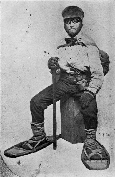
Wisconsin State Representative
and co-founder of Ashland
Asaph Whittlesey
As the matters have referred to one of vital importance to these several Bands of Indians, we earnestly hope that you will give your influence towards securing to them, all of the benefits named in the Treaty and as the subject named will demand labor entirely outside of the ordinary duties of an Indian Agent, and as it will be important for some one to visit the Reservations Inland, so as to be able to report intelligently upon the actual State of Things, we respectfully suggest that Mr Asaph Whittlesey be specially commissioned (provided you approve of the plan and you regard him as a suitable person to act) to attend to the taking of the necessary depositions and to present these claims, with the necessary maps and Statistics, before the Commissioner of Indian Affairs at Washington, the expense of which must of necessity, be met by the Indian Department.
Mr Whittlesey was present at the making of the Treaty to which we refer, and is well acquainted with the wants of the Indians and with what they of right can claim, and in him we have full confidence.
In addition to the points herein named should you favor this commission, we would ask him to attend to other matters affecting the Indians, upon which we will be glad to confer with you at a proper time.
The undersigned L H Wheeler and Henry Blatchford have no hesitency in saying that the representations here made are full in accordance with their understanding of the Treaty, at the time it was drawn up, they being then present and the latter being one of the Interpreters at the time employed by the General Government.
Most Respectfully Yours
Dated Odanah Wis July 1861
Names of those connected with the Odanah Mission
[None identified on this draft petition]
Names of Chiefs who were signers to the Treaty of Sept 30th 1854
[None identified on this draft petition]
Although this draft was not signed by Wheeler or Blatchford, or by the tribal leadership that they appear to be assisting, Chequamegon History believes it is possible that a signed original copy of this petition may still be found somewhere in national archives if it still exists.
Asaph Whittlesey Incidents: Number V
October 2, 2018
By Amorin Mello
Originally published in the March 16, 1878, issue of The Ashland Press. Transcribed with permission from Ashland Narratives by K. Wallin and published in 2013 by Straddle Creek Co.
… continued from Number IV.
Early Recollections of Ashland: Number V
by Asaph Whittlesey
—
FIRST ELECTION IN THE TOWN OF BAY PORT.
The order of the County Board creating the Town of Bay Port was made March 11th, 1856, and the store of Schuyler Goff in Bay City was designated as the place for holding the first election for town officers, the election to be held April 1st, 1856.
The journal containing this order (which was in pamphlet form,) was destroyed by fire at the burning of the Webb House in Bayfield, Wis., June 4th, 1874.

Detail of La Pointe County from a map of Wisconsin published by J. H. Colton & Co., New York, 1856.
~ David Rumsey Map Collection
The new town comprised all that portion of La Pointe county, Wis., laying south of the north line of town 48 north, in all over sixty eight townships, including the Bad River Indian Reservation, which was, on the 8th of Nov. 1859, made a precinct by itself.
At the election held April 1, 1856, there were twenty-four votes cast, resulting as follows: For Chairman of Town Board, Schuyler Goff; remaining member of Town Board, J. T. Welton and Asaph Whittlesey. Schuyler Goff, Chairman elect, was the first to qualify, his oath of office being administered by Asaph Whittlesey, Justice of the Peace.
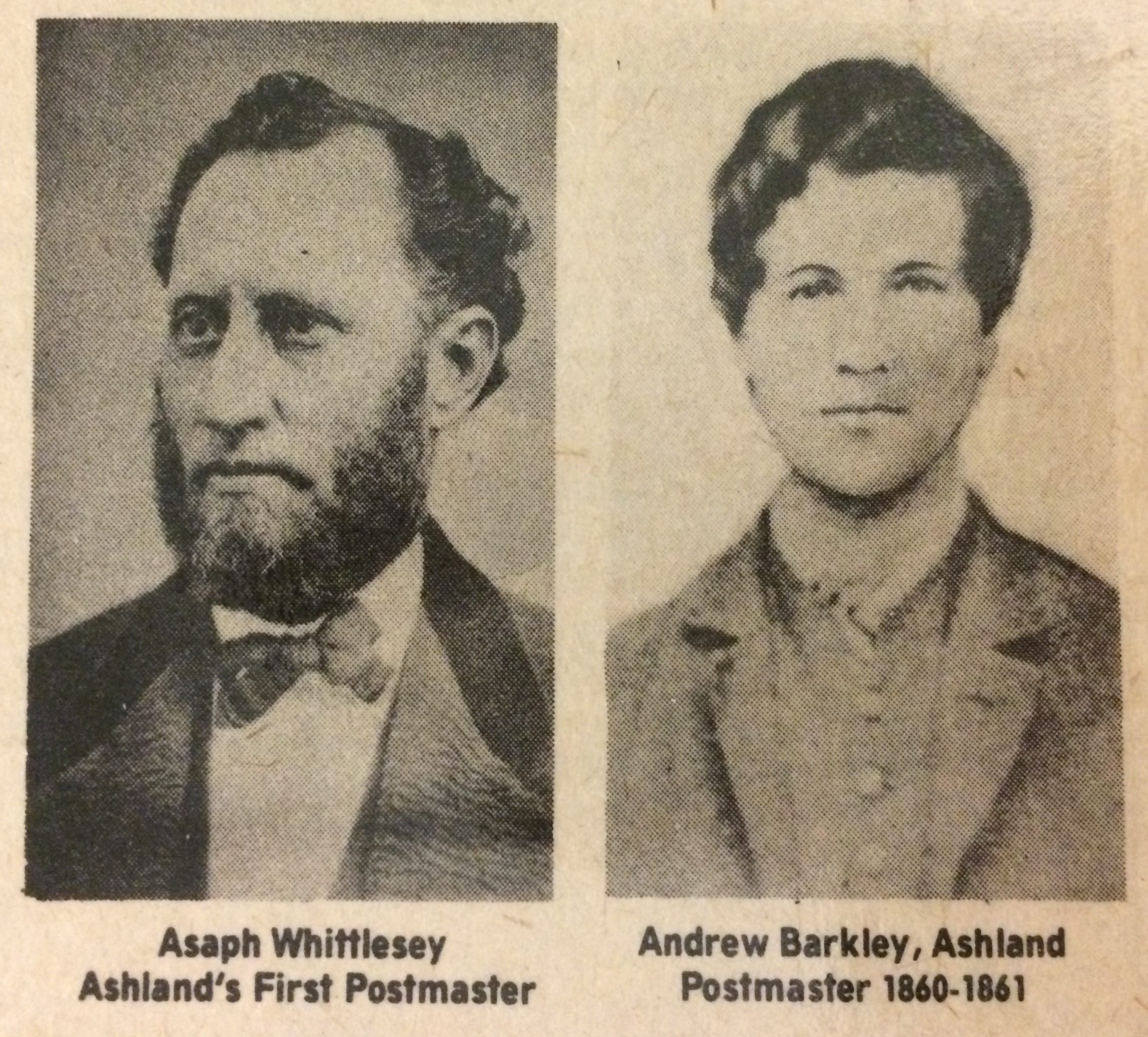
Photographs of Asaph Whittlesey and Andrew J Barkley reproduced from the Ashland Daily Press – national bicentennial issue (July 1976).
The annual statement made in April, 1857, showed the outstanding indebtedness of the town to be $25.00. The report submitted in April, 1858, showed highway orders issued during the year previous $57.50. Town indebtedness in April, 1858, was $22.75, and at that election there was levied the sum of $195.59, to meet the town expenses for the ensuing year. The following were the bills allowed by the town meeting in April, 1857: The first allowed was the bill of Edwin Ellis for $9.25; 2nd, J. T. Welton, $9.00; 3rd, A. J. Barkley, $5.50. In those days no bills were allowed nor orders drawn to cover them until the same had been approved at the town meeting. They had not yet learned to audit accounts with the marvelous rapidity known to Town Boards of more recent dates. However the Town Clerk comprehending this groans out as follows: “The vaults of the Treasuring are declared empty, and the servants of the town will therefore be obliged to wait for their pay until money shall be assessed and collected.”
Again. By referring to the Records of La Pointe, (being two years previous to the organization of the town of Bay Port,) Charles Pulcifer, acting as town treasurer, certifies that “the only unpaid personal property tax was that of J. W. Bell, amounting to $33.00, and that he was unable to find any goods on chattels belonging to the said Bell to enable him to collect the tax.
The assessment for 1857 made by Edwin Ellis for which allowance of $6.00 was made. At the annual town meeting in 1858 the first bill acted upon was that of Asaph Whittlesey, Superintendent of schools, amounting to 75 cents, though it was not allowed as they claimed it was out of their jurisdiction. – Bills of Edwin Ellis and Rev. L. H. Wheeler, for work done on the highway was rejected. It was resolved at this meeting that thereafter one shilling per hour be allowed for work on the highway.
OUR EXPERIENCE IN RAILROAD MATTERS.
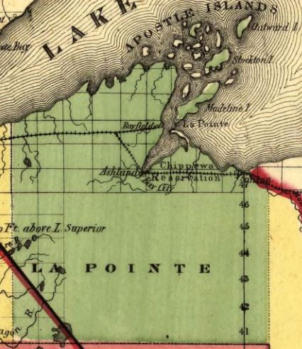
Detail of La Pointe County from a map of Wisconsin published by The Milwaukee & Horicon Rail Road, 1857.
~ Library of Congress
We often fall into the habit of complaining because things move so slow, and especially is this system of fault finding associated with the delays usually experienced in the construction of railroads in the west. However, upon reflecting I find that my time in life embraces the entire history of railroads in the United States, nearly the first roads put into operation, (if not the very first,) were one from Baltimore to Washington and one from Albany to Schenectady, N.Y., over which it was my good fortune to pass before reaching my majority, and about the time I became of age, it was my fortune to ride over not only the first railroad constructed in Illinois, bu the first built in the Mississippi valley, to wit: from Meredosia, on the Illinois River, to Springfield, a distance of forty miles, which, in its day, was regarded something not to be sneezed at, as the roads I have named were at least suggestions of the great systems of roads today. Governor Donenn, of Illinois, in his message of 1835-6, referred in the most glowing language to the triumph of the canal boat and the locomotive in almost annihilating time, burden, and space in other parts of the country and wanted to known if the Patriot bosoms of Illinois did not beat high to emulate such examples of internal improvement.
There were at different times two locomotive run over the Illinois roads mentioned, and finally mule power was resorted to. – The following year an Internal Improvement Bill was passed and roads were laid out for every quarter of the State, the results of which was to bankrupt the State. But the movement was not without its advantages, as by the following spring the forty miles reaching to Springfield was graded and ready for the track to be laid. The track was laid by putting down a piece of square timber called a mud sill on the top of which cross ties were laid. On these a wooden rail was laid and flat bars of iron were spiked on the top of the rail. These bars were tow and one half inches wide and one inch thick, and upon this track turned the wheel of the first locomotive brought into the Mississippi valley.
It might be called a curious contrivance, since the locomotive was simply a piece of clumsiness and of no practical use, the driving wheels being only about two and a half feet in diameter, and the engine itself having very little power. This road finally passed out of the hands of the State for a consideration of $100,000, in State indebtedness, while the actual cost to the State was $1,000,000.
I have dwelt somewhat long and in general terms upon the subject of railroads in the United States, to show to my readers that there has been no want of energy in their construction, but on the contrary the rapidity with which they have penetrated the wilderness is simply marvelous, converting Indian wilds into prosperous cities or fields of golden harvest. My own connection with the building of railroads dates no farther back then the time of my landing here in 1854, since which, I have in my way left no stone unturned looking to the introduction of railroads into this country. I was for a time a director in the St. Croix and Lake Superior Railroad Company, during which (but for the complications of the road,) Gardner Colby would have undertaken its construction instead of turning his attention to the Wisconsin Central Railroad.
To be continued in Number VI…
Edwin Ellis Incidents: Number IV
August 31, 2018
By Amorin Mello
Originally published in the July 14th, 1877, issue of The Ashland Press. Transcribed with permission from Ashland Narratives by K. Wallin and published in 2013 by Straddle Creek Co.
… continued from Number III.
EARLY RECOLLECTIONS OF ASHLAND.
“OF WHICH I WAS A PART.”
Number IV
My Dear Press: – In March 1855, Conrad and Adam Goeltz – then young men, came to Ashland. They were natives of Wittenberg, and Conrad had served six years in the Cavalry of that Kingdom; but liking freedom, he bade adieu to the King, his master, and came to the “Land of the Free.” They both cleared land near the town site, which they afterwards pre-empted, and bought from the U.S. Government. For several years both of them lived in Michigan, but upon the revival of Ashland they came back to their early home. Katy Goeltz, Conrad’s Daughter, was the first white child born in this town, in the fall of 1855. Henry Dretler, Mrs. Conrad Goeltz’s father, came early and bought a quarter section of land. He died here in 1858 and was buried near the present residence of Mr. Durfee.
In June 1855, Dr. Myron Tompkins (brother-in-law of Mr. Whittlsey) came to the bay in search of health. He had been driven from Illinois by ague and rheumatism. The climate cured the ague, and accidentally falling off from a raft in the bay – the severe shock cured the rheumatism. Being thus cured by our climate and water, he has ever since lived on the lake. He is a well-educated physician. At present he is the physician of the Silver Islet Mining Company, on the North Shore of the Lake.
I recall others who came in 1855; Andrew Scobie, now of Ontonagon, Thomas Danielson, Charles Day, (now farming on Fish Creek,) Joseph Webb, Bernard Hoppenjohn, Duncan Sinclair, Lawrence Farley, and Austin Corser. Farley died many years ago, but his widow, after years of absence, has again returned to Ashland. Austin Corser in the summer of 1855 began a farm on the east side of Fish Creek, about half a mile above the mouth. Remaining only two or three years, he went to Ontonagon and afterwards to Iron River – in a wild lonely glen – where in after years from 1873 to 1876. He sold his homestead on which the Scranton Mining Company was formed for a snug little fortune, on which he settled down on a farm near Waukegan, Illinois.
John Beck, also coming in the early days of Ashland. He pre-empted and lived upon the spot now laid out and occupied as our cemetery. His wife was the first adult person who died in this town. The remains of the house in which she died may be seen near the Ashland Lumber Company’s store. He was for many years an active explorer for minerals, was the originator of the Montreal River Copper Mining Company. Subsequently he discovered silver lodes on the North Shore, in Canada. He is now engaged in gold mining in California.
Albert C. Stuntz was also one of our early settlers. He is a brother of Geo. R. Stuntz, to whom reference has already been made. He was here engaged in practicing surveying and ran many hundred miles of township and section lines in this and neighboring counties. The townships embracing our Penoka Iron Range were subdivided by him in 1856 and ’57. He once represented this district in the Legislature. His old home is in ruins on the east bank of Bay City creek. Mrs. Stuntz, who endured much hardship and privation died here in 1862. Mr. S. at present lives at Monroe, in this State.
Geo. E. Stuntz. nephew of A.C. and great grandson of the old Hessian Soldier mentioned in a former chapter, also came to Ashland early. In connection with his uncle and on his own account he did a great deal in the subdivision of the lands on the South Shore of the Lake. Soon after the outbreak of our civil war he enlisted in defense of the Union – was severely wounded and died, as it is supposed, in consequence of his wounds.
~ Sarah Adah Ashe – Part IV – San Bernardino by Marta Tilley Belanger

Welton’s mill and Sibley’s farm were both located along the trail south from Ashland to the Penokee Mountains on the 1860 Geological Map of the Penokie Range by Charles Whittlesey.
~ Geology of Wisconsin. Survey of 1873-1879.
Volume III., 1880, Plate XX, page 214.
J. T. Welton and T.P. Sibley, though never living in Ashland, were yet closely identified with its early history. Mr. Welton came about 1850 to Bad River, where he was Government Farmer among the Indians. He was an ingenious mechanic, and could build a water mill. He was on the lookout for a mill site, and finally in 1854 discovered the falls on White River, six miles south of Ashland. It was an unfailing supply of water, with abundant head and fall, and the river was not subject to great rises. As a mill site it has few rivals. His resolution was quickly formed. The rising town on the bay would afford a ready market for all the lumber he could make. The mill should be built. He corresponded with his brother-in-law, Mr. Sibley, and he was eager to come and make his fortune in this new country; and in Nov. 1855, Mr. Sibley and his wife and one little daughter, about a year old, landed upon our shores. During the summer of 1855 Mr. Welton had built a log house at White River. It still stands, though in ruins. Thither late in Nov. 1855, the two families removed. The sisters were refined, cultivated and Christian ladies from the Western Reserve, in Ohio – a spot itself favored by counting among its early settlers some of the best families of New England, and which had been the new center in the west, whence have validated those influences which have tended to improve and elevate the moral and religious condition of the millions of this new empire. They were of Puritan stock. An unbroken wilderness was around them and their nearest neighbors were at Ashland, six miles away. No time was lost. The work of opening up a farm and building a mill was at once begun. They had little money and the labor must be done with their own hands. The casting for the mill must be brought a thousand miles – from Detroit. Nearly a year of toil had passed, when in October, 1856, a few days before the election of James Buchanan to the Presidency – all the able bodied men were invited to go the mill raising at White River. We went and the frame was up, but it was not until 1857 that they could set the mill running. They were greatly impeded for want of capital in cutting logs and floating down the logs to the mill and sawing a few thousand feet of lumber. But before anything could be realized from it they must either haul it over bad roads to Ashland (6 miles) or raft it down many miles to the Lake. But the river was full of jams and “flood wood” – enough to discourage puny men.
The panic of 1857 and resulting hard times put an end to all building at Ashland, and so their hopes of selling their lumber near home were blasted and after struggling vainly for some time longer, Mr. Welton was finally compelled to abandon his home, which he had labored so hard to establish. He found friends and employment in the copper mines of Michigan, and after somewhat improving his fortunes finally settled in south western Iowa, where he now resides.
In some subsequent chapter I will, with your leave, recur to Mrs. Sibley and the circumstances connected with her death.

