1855 Yom Kippur at La Pointe
December 18, 2016
By Amorin Mello

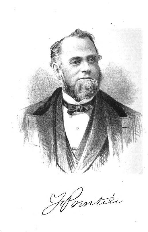
Photograph of Julius Austrian from the Madeline Island Museum
One of the more colorful figures from primary sources of Chequamegon History is Julius Austrian at La Pointe. Austrian is also one of the more elusive, as he is often overlooked and omitted from secondary sources.
My research of Austrian is what originally inspired me to begin contributing to Chequamegon History. I have been working behind the scenes on a series of stories about Austrian featuring extensive collections of primary documents to shed more light on his life at La Pointe during the 1850’s, and look forward to publishing them at a later date.
One story in particular is about Austrian’s, and his family’s, involvement with the 1855 La Pointe annuity payment, one of the most colorful events in Chequamegon History. A brief introduction to the 1855 La Pointe annuity payment is needed for context, so I refer to a quote from Leo in an earlier post of his: A real bona fide, unmitigated Irishman:
“Regular readers will know that the 1855 La Pointe annuity payment to the Lake Superior Chippewa bands is a frequent subject on Chequamegon History. […] The 1855 payment produced dozens of interesting stories and anecdotes: some funny, some tragic, some heroic, some bizarre, and many complicated. We’ve covered everything from Chief Buffalo’s death, to Hanging Cloud the female warrior, to Chief Blackbird’s great speech, to the random arrival of several politicians, celebrities, and dignitaries on Madeline Island.”
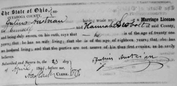
At this moment in Chequamegon History, Austrian was a powerful resident at La Pointe in terms of private land ownership and political savvy. Austrian was a signatory of the 1847 Treaty at Fond du Lac, but not a signatory of the 1854 Treaty at La Pointe. However, primary sources reveal that Austrian was the owner of La Pointe during the 1854 Treaty, and received financial reimbursement from the Department of Interior for services related it. A letter from Reverend Leonard Wheeler at Odanah dated January 18, 1856, asserts that the 1855 annuity payment at La Pointe was hosted by Austrian:
“The following is the substance of my notes taken at the Indian council at La Pointe a copy of which you requested. Council held in front of Mr. Austrian’s store house Aug 30. 1855.”
I have come across secondary sources that allude to Austrian’s role as the host of the 1855 Yom Kippur at La Pointe immediately after the annuity payments, but have not yet been able to locate any primary sources. This post cites secondary sources in hopes that another researcher may review them and help me find primary sources. Having a background in Jewish studies would be helpful, as it is possible primary sources about the 1855 Yom Kippur at La Pointe were written in the Hebrew language rather than in English. Please contact Chequamegon History if you can help find and translate primary sources.
Without further ado, here are secondary sources about the 1855 Yom Kippur at La Pointe listed chronologically by their publication dates.
The Beth El Story: With a History of the Jews in Michigan before 1850
by Irving I. Katz
Wayne University Press (1955)
ISBN-10: 0-7837-3584-7
ISBN-13: 978-0-7837-3584-9
Pages 53-54:
“Lewis F. Leopold, whose name was Freudenthaler in his native Baden, Germany, his wife, Babette, who was a member of the Oesterreicher (Austrian) family, their infant son, Lewis’ sister, Hannah, and Lewis’ brother, Samuel, were located on the Island of Mackinac in 1845. The brothers became the first pioneers in this locality in the fishery business and were soon shipping a thousand barrels of salted fish to Cleveland each season. This business, together with the sale of supplies to fishermen, Indian trading and the purchase of furs, laid the foundation for an extensive business and they became prominent as owners of Lake Michigan vessels and merchants in the ports of the Great Lakes.
“Samuel Leopold left Mackinac in 1853 to join his two other brothers and Julius Austrian, who had married Hannah Leopold in 1849, in their recently undertaken business enterprises at La Pointe and Fond du Lac, Wisconsin, where they were among the first white settlers. Lewis Leopold officiated as cantor at the first High Holy Day services held at La Pointe in the fall of 1855. Within a few years after 1850, the Leopolds and Austrians established leading stores in Michigan, at Eagle River, Eagle Harbor, the Cliff Mine, Calumet, and at Hancock, Joseph Austrian having selected the latter place as the site for his first store and warehouse.”
Mount Zion, 1856-1956: The First Hundred Years
by W. Gunther Plaut
North Central Publishing Company (1956)
ASIN: B0007DEZ4W
Page 24:
Minnesota Pioneer article about Julius Austrian and his Chippewa mixed-blood employee Vincent Roy, Jr. in Saint Paul as republished in The Daily Crescent (New Orleans, LA), February 24th, 1851. Roy also worked for Austrian and Leopold at La Pointe, Fond du Lac, and Vermillion Lake.

“Julius Austrian was perhaps one of the most colorful figures not merely in the history of the Congregation but in the larger Minnesota community as well. His wife, the former Hannah Leopold (in Germany, the name had been Freudenthaler), at once became an undisputed leader among the Jewish women. The couple had married in 1849 and were among the first white settlers at La Pointe and at Fond du Lac, Wisconsin. Others of the family joined them later. High Holy day services are recorded at Fond du Lac as early as 1855. Austrian laid claim to mineral rights and lands in what later became part of Duluth. 1851 he once made the trek south to St. Paul in the dead of the winter – and arrived in St. Paul with two dog trains and several hundred pounds of freight. The Minnesota Pioneer duly reported that this ‘excited much curiosity in our town.’ The Austrians and Leopolds, who may be reckoned as among the earliest pioneers of the region, later had stores in a number of Michigan towns; and when Julius and Hannah moved to St. Paul, their reputation had preceded them. But unlike his wife, Julius Austrian preferred the quiet, behind-the-scenes type of leadership. When funds were low, he would make up the deficit; and at least on one occasion, so the minute book records, he guaranteed the Rabbi’s salary. He wrote a fine hand, both in English and in Hebrew, as is attested by the cemetery records which he kept for many years.”
The Jews in Minnesota: The First Seventy-Five Years
by W. Gunther Plaut
American Jewish Historical Society (1959)
ISBN:
Pages 12-14:
“When Abram Elfelt became Vice-President of the new Minnesota Lodge No. 157, B’nai B’rith, his fellow officer and treasurer was a man by the name of Julius Austrian. The two had known each other for many years, for while Austrian did not come to St. Paul until after the Civil War he, too, had been in the Territory when it was still part of Wisconsin.

Julius Austrian (Oestreicher) immigrated with his sister Babette Austrian (Babet Oestreicher) (wife of Louis F. Leopold) and their brother-in-law Henry F. Leopold (Heinr Freudenthal).
~ “New York Passenger Lists, 1820-1891,” image 19 of 895; NARA microfilm publication M237 (Washington D.C.: National Archives and Records Administration, n.d.).
“Austrian was one of five brothers. In the old country, their name had been Oesterreicher or Oestreicher. Julius must have had an adequate Jewish education, for he could write Hebrew with a sure hand and had deep and definite religious convictions. In the late forties he, his brother Marx, and Lewis Leopold had gone up to LaPointe, Wisconsin, on Lake Superior, where they were among the first white settlers. As early as 1855, they held Holy Day services in this outpost of civilization.
“In 1849, Julius had married his partner’s sister, Hannah Leopold, a girl who was then not quite nineteen years old. Their business prospered; stores were established on the northernmost part of Michigan’s Upper Peninsula: in Eagle River, Eagle harbor, Cliff Mine, Calumet and Hancock, where their store and warehouse were located.
Marriage license application for Julius Austrian and Hannah Leopold.
~ “Ohio, County Marriages, 1789-2013,” image 47 of 229.
“The Austrians and Leopolds traded throughout the area and soon extended their contacts into Minnesota. Even during the summer, it was quite a journey to St. Paul, but only the hardiest person would gather enough courage to make it during the winter. No wonder, therefore, when Julius Austrian dared it in January, 1851, the press recorded that his arrival ‘excited much curiosity in our town.’ He came with another person from Lake Superior via the Falls of St. Croix. Their mode of transportation was the northern dog-train. In their two sleds they brought several hundred pounds of freight for trading.
“Austrian soon became a land owner in Minnesota. He acquired mineral rights at Lake Superior on a site where later the city of Duluth was built. In the late sixties, he and his brother Marx moved to St. Paul where Julius and Hannah at once became two of the leading Jewish citizens. For they soon proved their strong Jewish loyalties and unusual leadership qualities.
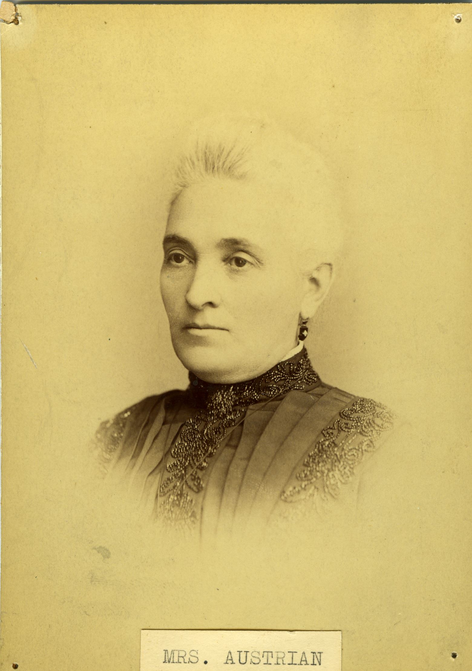
Photograph of Hannah Leopold Austrian from the Madeline Island Museum.
“When they came to St. Paul, the Civil War was over, and whatever little Jewish institutional life there had been in Minnesota was left in very poor circumstances. The two Austrians were soon engaged in building up the congregation. They helped to find the means for erecting the young state’s first synagogue. Hannah founded its first women’s group and headed it in its work for the Temple and in its increasingly ambitious welfare and social enterprises until after the turn of the century. Under her presidency Mount Zion’s women founded the St. Paul Neighborhood House. In 1897, she was feted lavishly on her twenty-fifth anniversary as president of the Temple auxiliary. She was a stocky woman, coupled with a wonderful sense of humor. She died in ripe old age in Chicago, where she had gone to live with her daughter, who had married Amiel Hart. Hannah’s passing was noted with great sorrow in her old community to which she had given so much.
“The Austrians were moderate in their outlook; they were Reformers, but of the evolutionary kind. Julius was, until his death in 1891, a mainstay of Mount Zion Hebrew Congregation. More retiring than his wife, he preferred a trusteeship or vice-presidency to the chair itself. He was responsible for bringing Leopold Wintner was the first ordained Rabbi to Minnesota; for when his fellow members were fearful of committing themselves to a contract he personally agreed to underwrite it. His special concern was the cemetery of Mount Zion, the first Jewish burial ground in the state. He kept its records in English and Hebrew, and some of the social background of the earlier days can be read in his private obituary notes.
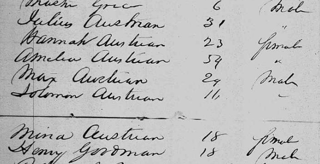
Marx Austrian immigrated to the United States during 1853 with his mother, several of his siblings, and cousin Henry Guttman (Goodman).
~ “New York Passenger Lists, 1820-1891,” image 499 of 671; NARA microfilm publication M237 (Washington D.C.: National Archives and Records Administration, n.d.).
“His brother Marx (more often he was known as Max) was blind from early youth on. Still he pioneered with the rest of the family, and the Indians at Lake Superior loved the handicapped white man. In St. Paul, whither he removed with Julius and Hannah in 1869, he was known as a man of dignity and piety. For many years he blew the shofar at Mt. Zion’s Holy Day services. He outlived Julius by twelve years.”
United States Jewry 1776-1985.
Vol. 2: the Germanic Period, Part 1
by Jacob Rader Marcus
Wayne State University Press (1991)
ISBN-10: 0-8143-2187-9
ISBN-13: 978-0-8143-2187-4
Page 196:
“By the 1850’s America was studded with Jewish societies, one even on the High Plains. How rapid was the organizing process? In general a whole generation elapsed, possibly two, after the coming of the pioneers before the first communal society came into being. In some states, as in Florida and Connecticut, it would take decades before the Jews would established a congregation. There are some striking exceptions. In 1855 a number of Jewish Indian traders met on an island in Lake Superior in the frontier village of La Pointe, Wisconsin. The Indians were assembled there to collect their annuities and the Jews were present to dun their debtors before they dispersed. There were enough Jews for a minyan and a service was held. That was the beginning and the end of La Pointe Jewry. Another historical accident is the “instant” community. The Jews of Savannah arrived from London in 1733 already organized as a congregation; San Francisco Jewry of the Gold Rush was able to establish two religious groups without delay and Oklahoma City and Guthrie were born overnight during the 1889 ‘run.’ All this is completely atypical.”
Jewish Pioneers of Saint Paul: 1849-1874
by Gene H. Rosenblum
Arcadia Publishing (2001)
ISBN-10: 0-7385-1862-X
ISBN-13: 978-0738518626
Page 75:
“Julius Austrian was one of the more influential and colorful Jewish pioneers. In 1849, he and his wife Hannah Leopold Austrian were among the first white settlers in La Pointe and Fon Du Lac, Wisconsin, at a time when the Minnesota Territory was part of the Wisconsin Territory. In 1855, they had participated in the Jewish High Holiday services in La Pointe. He was already a successful businessman when he and his family came to St. Paul in 1869 from Wisconsin. He had a string of successful stores throughout the Upper Michigan Peninsula. He also had already acquired claims in mineral rights around Lake Superior, where the city of Duluth now stands. He was a man of great generosity, and when the fledgling Mt. Zion Synagogue was unable to hire its first rabbi, he guaranteed payment. He also was a moving force in the failed attempt to establish the Painted woods colony in North Dakota.”
Page 79:
~ Mount Zion Temple
~ Mount Zion Temple
“Two significant events took place in 1869 that had a permanent impact on the pattern of communal life within the St. Paul Jewish community. The first event involved the more orthodox of the settlers. Dissatisfied with Mt. Zion, they began to gather together for private prayers in a frame house on Payne Avenue near Seventh Street in the Dayton’s Bluff near East Side area. They were the roots for the first strictly orthodox synagogue in Minnesota and established what later became the Sons of Jacob Synagogue. At this point, Mt. Zion began its slow evolution toward Reform Judaism. The second event involved a husband and wife team who were to have far reaching influence. Julius Austrian and his wife Hannah arrived in St. Paul in 1869 when the Jewish communal institutions were in very poor circumstances.
“Julius Austrian was one of five brothers. In the old country their name was Oestrreicher. In the late 1840s, his older brothers, Marx Austrian and Lewis Leopold, had gone to La Pointe, Wisconsin, on Lake Superior, where they were among the first white settlers. As early as 1855 they held High Holy Day (Yom Kippur) services in La Pointe, Wisconsin. In 1849, Julius married Lewis Leopold’s sister Hannah, who was not quite 19. In 1851, he made a trip south to St. Paul in the dead of winter and arrived with two dog trains and several hundred pounds of freight.”
Ashland, Wisconsin: Its Early Days
November 29, 2016
By Amorin Mello
Magazine of Western History Illustrated
November 1888
as republished in
Magazine of Western History: Volume IX, No. 1, pages 12-17.
—
ASHLAND, WISCONSIN:
ITS EARLY AND PRESENT DAYS.
—

Detail of Lapointe du Saint Espirit and Mission du Saint Espirit from Claude Allouez Map of New France, 1669.
~ Research Laboratories of Archaeology
If the reader will look at the map of the United States, he will see on its northern boundary the largest body of fresh water in the world – Lake Superior, called by the Ojibways Kitche Gumi, “The Big Water.” It lies between 46 and 47 degrees north latitude, and stretches east and west through eight degrees of longitude. Its coast-line is nearly two thousand miles in extent, forming some of the finest natural harbors in the world. Its surface is six hundred and thirty feet above the ocean level, while its bottom in the deepest parts is four hundred feet below the level of the tide-waters. As you come from the east end of the lake, St. Mary’s river, approaching its western extremity, you will, from the deck of the steamer, notice a group of beautiful islands – the same islands which, more than two hundred years ago, met the gaze of Fathers Marquette, Allouez and Mesnard, and which, in their religious zeal, they named the “Apostles’ Islands,” thinking that in number they corresponded with the number of our Savior’s disciples. One of these they named “Madeline,” from a favorite saint of their own “Belle France,” and to commemorate one of the most noted churches of Paris.

Detail of “The 12 Apostles” from Captain Jonathan Carver’s journal of his travels with maps and drawings, 1766.
~ Boston Public Library
These islands in ancient times were doubtless a part of the main, as was also the land now lying under Ashland bay. Underlying them was sandstone, rising from twenty to one hundred feet above the water, and horizontal. The great glaciers coming from the north, and moving in a southwest direction, cut channels in the sandstone, forming these islands, and scooping out of the solid rock the large basin which, in after years, received the name of Chaquamegon bay, and which is now known as Ashland bay. This was the first prophecy of the city of Ashland. In the times, millions of years before this, the vast deposits of iron ore had been upheaved and stored along the south shore of the lake, to subserve the designs of the Mighty Builder in the development of that commerce of which we now see but the earliest down, and of whose future extent we can form but a faint comprehension. Chaquamegon, Le Anse and Marquette bays are the natural outlets on Lake Superior for the rich mineral deposits which line its southern shore.
The formation of Ashland bay was therefore not accidental, but in harmony with Eternal plans. It is protected from the storms of the lake by a long, low, sandy point, and also by the Apostles’ islands. Into it open from the lake three broad channels, with a depth of water ample for the largest vessels, called the North, Middle and South channels. Under these islands, vessels coming from the wild storms of the open lake are secure. It is the sailor’s haven of safety.

1834 Map of LaPointe by Lyman Warren for the American Fur Company.
~ Wisconsin Historical Society
The first settlement on the bay was made by the American Fur company in the early part of the present century, on the beautiful Madeline island, and named La Pointe. It continued for many years the headquarters of a flourishing fur and fishing trade. About 1830 a Protestant and, soon after, a Catholic mission were established there, and churches built by them, in which devoted missionaries labored to Christianize and civilize the Indians whose homes were here and in the surrounding country. Here toiled Rev. Sherman Hall, a missionary of the American board, and Rev. L. H. Wheeler, and also that devoted man, now known to us as Bishop Baraga. These have all passed away. La Pointe, then the most populous and active village on the lake, is now, alas, “The deserted village,” and is visited alone in veneration of its past memories.

Map inset of Chequamegon Bay with Houghton, LaPointe, Bayfield, Ashland, and Bay City.
~ Wisconsin Historical Society
On the west shore of the bay, opposite La Pointe, is the beautiful town of Bayfield, founded by Honorable Henry. M. Rice in 1856. It is the terminus of the C., St. P., M. & O. railroad and the headquarters of a flourishing fish and lumber trade, and one of the most charming summer resorts on the lake.
On the west shore of the bay is also the flourishing town of Washburn – named in honor of Wisconsin’s governor, Cadwallader C. Washburn. It is the favorite town of the Omaha railroad, and has several large saw-mills, and is an active and enterprising town.

Asaph Whittlesey circa 1860.
~ Wisconsin Historical Society
The first settlement on the spot where Ashland now stands was made, in 1854, by Asaph Whittlesey and George Kilborn, both natives of the Western Reserve, Ohio. The lands were not as yet surveyed, so that they could not preëmpt them, and there was as yet no Homestead law. For this reason they, with Martin Beaser, then living in Ontonagon, Michigan, laid claim, under the “Town Site” law, to about three hundred acres, embracing their log houses and small clearing. They platted this into town lots in 1855, and subsequently were allowed to enter their lands as claimed, and in due course received their title. In February, 1855, Edwin Ellis, a graduate in medicine, in the University of the City of New York, of the class of 1846, came on foot through the woods from St. Paul to the bay. He had been engaged in the practice of his profession in his native state – Maine – till 1854, when, attracted by the prospect of wider fields for enterprise in the new west, and by the advice of Judge D. A. J. Baker, his brother-in-law, then living in St. Paul, he came to Minnesota.

Edwin Ellis, M.D.
~ Commemorative Biographical Record of the Upper Lake Region by J.H. Beers & Co., 1905, pages 16-18.
The years 1853 to 1857 were years of wild speculation. The states of Wisconsin and Minnesota especially were covered with rising cities – at least on paper. Fabulous stories of rich silver, copper and iron mines on the south shore of Lake Superior attracted a multitude of active young men from the eastern states. The city of Superior had been laid out, and its lots were selling for fabulous prices. The penniless young man of to-day became the millionaire to-morrow. The consequent excitement was great, and in the event demoralizing.
The Bay of Ashland, stretching far in-land, the known vast deposits of iron near the Penokee Gap, whose natural route to market was evidently by Chaquamegon bay, indicated with moral certainty that at its head would rise a commercial mart which should command a wide extent of country. The vast forests of pine were then hardly thought of, and no efforts made to obtain them. The lands were unsurveyed, and all the “squatters” were, in the eye of the law, trespassers. Nevertheless, the new-comers ran “spotted” lines around their claims and built log-cabins to hold them, and began to clear up the land. In June, 1855, Dr. Ellis went on foot to St. Paul, and thence to Dubuque, Iowa, and secured from the surveyor-general an order to survey four townships about the bay, embracing the site of the present city of Ashland. In the meantime, many settlers had come in and preëmpted lands in the neighborhood. In the fall of 1855 many of them were enabled to prove up and get titles to their lands.
Portrait and biography of Frederick Prentice; the “first white child born in … Toledo.”
~ History of the Maumee Valley by Horace S Knapp, 1872, pages 560-562.
In the winter of 1855 Lusk, Prentice & Company, who had a trading-post within the present limits of Ellis’ division of Ashland, built a dock for the accommodation of the settlers coming to the new town. It was built of cribs, made of round logs sunk in the water about twenty feet apart. From one crib to another were stringers, made of logs, flattened on the upper surface, all covered with small logs to make a roadway. On the docks were piled several hundred cords of wood for the purpose of “holding” the dock from floating away, and to be sold in the summer to the steamboats which should come to bring supplies and begin the commerce of the town. The evening of the second day of April, 1855, saw the bay full of ice, slightly detached for a few feet from the shore, but with no sign of an immediate opening of navigation.

Portrait of Martin Beaser on page 24.
The next morning no ice was in sight, nor a vestige of the dock to be seen. Floating timber and cord-wood covered the bay. Till then the settlers had no idea the power of the floating ice moved by the tide of the bay. But they were not discouraged. The following winter two other docks were constructed – one by Martin Beaser, at the foot of what is now called “Beaser Avenue,” and the other by Edwin Ellis, near where Seyler’s foundry now stands.
These were also crib-docks, but the effort was made to anchor the cribs. There were no rocks to be had on the side of the bay where the docks were built, for which reason Mr. Beaser filled his cribs with clay, dug out of the banks. Dr. Ellis hauled stone across the bay, and filled as many of his cribs as possible, and on the top of the dock also piled several hundred cords of wood, and the settlers with anxious faces watched the departure of the ice. The shock came, and the docks afforded little resistance. The cribs filled with clay were easily carried. Those filled with stone stood better, but that part of those above water, and near the outer end, were swept away. The labors of many weary days and much money was thus swept away. There was, however, enough of the Ellis dock left to afford a landing to the few boats that came with supplies for the people.

Survey of Frederick Prentice‘s Addition of Ashland near the Gichi-wiikwedong village.
“It is in this addition, that, the Chippewa River and the St. Croix Indian trails reach the Bay, and for the purpose of accomodating the trade, already flowing in on their routes, a commodious store has just been built”
~ Wisconsin Historical Society
Translates as “Big Bay” in Ojibwemowin.
Traditional place-name for Ashland, WI.
Anglicized version of Gichi-wiikwedong.
Prentice Park and Maslowski Beach.
Area is famous for artesian wells.
“This was all Indian land then, but [Asaph] Whittlesey believed in take time for the forelock, looking he said, for a place that ‘might prove to be the most available point for a town, at or near Equadon (pronounced E Quay don, the second syllable emphasized.) The word ‘Equadon,’ is the Chippewa word meaning ‘settlement near the head of the bay.'”
~ The Ashland Daily Press, July 6, 1933, by Guy M. Burnham, reproduced on TurtleTrack.org. Read the full article for an interesting stories about how the town-site for Ashland was allegedly negotiated between Reverend Wheeler and Little Current.
During the years 1855, ’56 and ’57 many settlers had come to Ashland and built homes, and were all young men full of bright hopes for the future. In the spring of 1856 a township organization was formed, embracing more than forty townships of six miles square, and was called Bayport. The usual township officers were elected. The year 1857 opened with bright prospects. In Ashland streets were cleared and several frame houses were built. A steam saw-mill was begun and brought near completion. But in September of that year the great financial storm came, involving the whole country in ruin. The little village of Ashland was overwhelmed. The people had but little money, and in making their improvements had contracted debts which they could not at once pay. There had been so such speculation that the settlers had paid but little attention to the cultivation of the soil, depending upon supplies brought by water a thousand miles. We had no wagon roads nor railroads within three hundred miles. Winter was coming on, and many of the settlers – in truth, all who could get away – left the place. The few who remained saw hard times, whose memory is not pleasant to recall. Some of them, in making improvements, had assumed liabilities which well-nigh ruined them. If the county had then been organized for judicial purposes, so that judgements and execution could have been easily obtained, scarcely anyone would have saved a dollar from the wreck. But this fortunate circumstance gave them time, and their debts were finally paid, and they had their land left; but it then was without value in the market. Town lots in the village, which are now selling for five thousand to six thousand dollars, could then be sold for enough to buy a barrel of flour. The years following “’57” were hard years, and the settlers, one by one, moved away, so that in 1862 only two remained – Martin Beaser and Martin Roehn. In 1866 Mr. Beaser undertook to come alone from Bayfield to Ashland in an open sail-boat. It was a stormy day, and he never reached home. His boat was found soon afterwards at the head of the bay, and his body was found the following spring on the beach on the west side of the bay. Ashland was now left desolate and alone. Mr. Roehn, with a few cows, migrated backward and forward between Ashland and the Marengo river, finding hay and pasture for his cows, selling his produce and butter at Bayfield and La Pointe, and thus eked out an existence. The first railroad to reach Ashland was the Wisconsin Central, completed in 1877, connecting Ashland with Milwaukee. Work at the Ashland end was begun in 1872, and in 1873 finished to Penokee, twenty-nine miles south from Ashland. It had been built from the south to within about eighty-five miles of Ashland, and then came the panic of 1873, and all work stopped. The building in 1872 in Ashland was quite extensive, and village property sold at good prices, and everybody was hopeful. But the crisis of 1873 coming on, all enterprises at once stopped. Not till 1877 was the railroad completed. Its completion established Ashland on a substantial basis. In 1877 the Wisconsin Central company completed the Chaquamegon hotel, one of the finest in the country, which has added greatly to the attractions of Ashland.
The building of the Chicago, St. Paul, Minneapolis & Omaha road to this place, in 1883, gave a short outlet to the west and southwest, greatly benefiting the lumber trade.
The Northern Pacific, whose eastern terminus is at Ashland, soon after completed, gave it new importance as in the direct line of transcontinental commerce.
But the advent of the Milwaukee, Lake Shore & Western railroad had done more, perhaps to stimulate the growth of Ashland than any one of its great enterprises.
It runs northerly from Milwaukee to Manitowoc, where, turning in northwesterly course, it traverses vast tracts of valuable timber and farming lands, running for fifty miles along the Gogebic range – the richest iron region in the world.
This company has built two large and costly ore docks for the shipment of the vast amount of iron ore which it brings over its road.
South From Ashland
“The promoters decided to make Ashland the north end of their iron. It was a mere clearing, in the woods in 1870, formerly known as Equadon which was founded in 1854 and abandoned in 1863. The Ashland site was located on the bank of a splendid natural harbor called Cheguamegon Bay.”
…
“The clearing, grubbing and grading of the 30-mile Ashland-Penokee Gap Division had been practically complete in 1872. The iron rails were not laid into the Gap until October 1873, and there the railroad stopped for 4 long years.”
…
“Penokee Gap, 1000 feet above Lake Superior, is a break in the rough country, a regular gap where the Bad River breaks through the Iron Range Hills on its way to Lake Superior. The Gap is an historic pathway through which the copper workers from Mexico and South America came to Lake Superior centuries ago enroute to the copper deposits on Isle Royal in Lake Superior.”
~ History of the Soo Line, by James Lyden.
The Wisconsin Central Railroad company has also built a very fine ore dock, over which it ships the iron brought from the same range by its own line – the “Penokee Railroad” – built easterly along the northern base of the Gogebic range to Bessemer, in Michigan.
Notwithstanding the depression in the iron trade, more than a million tons of ore will be shipped from Ashland the present season.
Ashland has also two coal docks – one operated by the Ohio Coal company and the other by the Columbus & Hocking Valley Coal company – both of whom are doing a large business. The Lake Shore railroad and the Wisconsin Central obtain their coal for their engines, on the northern two hundred miles, by their docks at Ashland. The same rates for coal going west prevail as from Duluth and Washburn, and a large trade is springing up over the Omaha & Northern Pacific lines.
Ashland has three National and one private bank, all of which are conservative and carefully managed. It has also a street railway, two miles in length, with six fine cars and about forty horses, and is rendering very satisfactory service. We have also a “Gas and Electric Light Plant,” which affords abundant light for the streets, stores, dwellings and the ore docks. Ashland has also the Holly system of water-works, with about two miles of pipe laid, affording ample protection against fire and an abundant supply of water for domestic purposes. The pump-house has two ponderous engines, one being kept in reserve in case of accident.
As a point for the distribution of manufactured goods of all kinds, Ashland stands among the foremost. With practically the same rates as by the roads leading from Duluth west, it is prepared to compete with that lively town for part of the trade of the great northwest – now in its infancy but destined soon to attain great proportions; whose beginnings we can measure, but whose vast results we cannot now comprehend.
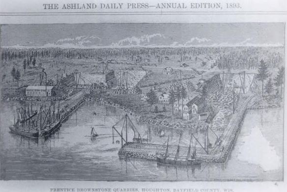
Portrait of Prentice’s brownstone quarries at Houghton Point.
~ Ashland Daily Press, circa 1893.
A Great Brownstone Industry Established At Houghton Point.
What Frederick Prentice Has Accomplished During The Season.“
~ Ashland Daily Press article in the Washburn Itemizer, October 18, 1888, reproduced on BattleAxCamp.tripod.com
One industry on Ashland bay is the brown stone, which exists along the water’s edge for many miles on the shore of the mainland and on the islands. It can be quarried in inexhaustible quantities within a few hundred feet of navigable waters of Lake Superior. It is of fine texture and beautiful color, and hardens by exposure. Large quantities have already been shipped and the demand is rapidly increasing. It can be shipped by rail at about four dollars per ton to Cincinnati. This stone, used for trimmings in buildings built of white brick, makes a very beautiful appearance.
The vast quantities of pine and hardwood timber in the vicinity of Ashland, and its advantages as a point of distribution for manufactured articles in wood, render it one of the best locations for manufacturing industries. For tanneries its location is unrivaled; the supply of hemlock bark is ample, while hides can be cheaply brought from Minnesota and the northwest, and the products can be shipped in all directions at low rates.
The schools of Ashland afford the best of opportunities for the education of our youth. Our school buildings are large, new and commodious, with all modern improvements. Our schools are graded and the attendance is large.
In the churches, most denominations are represented. The Catholic is the finest church edifice in the city, built of our own brown stone at a cost of over thirty thousand dollars. There are Presbyterian, Congregational, Episcopal, Baptist, Methodist, Lutheran and several Scandinavian churches.
As a summer resort, Ashland and the Apostles’ islands afford unrivaled attractions. Sail-boats, tugs and steamboats make daily excursions in all directions. They busy men from Chicago, St. Louis, St. Paul, Cincinnati and other cities can, in one day, escape from the sweltering heat and sleep on the cool ore of Lake Superior, and with our lines of railroad and telegraph stretching in all directons, they can be in constant and instant communication with their counting-rooms a thousand miles away. Its advantages in this line are already drawing many persons of wealth and leisure, as well as invalids, who come here to spend the hot season and at the close of the summer return home with new health and vigor.

Portrait of Edwin Ellis, M.D. on page 20.
Ashland has just two daily and three weekly newspapers, models of enterprise and very newsy, contributing much to the prosperity of the city.
The population of Ashland is about fifteen thousand, composed principally of persons under thirty-five years of age, and full of push and activity, who have come to stay and built up fortunes.
With all these and many other advantages Ashland seems to have a bright future, and many of us think it bids fair, in the near future, to become the second city in the state of Wisconsin. And we will labor that she shall be worthy of her rank.
EDWIN ELLIS.
Copper Creek Mining Location
November 18, 2016
By Amorin Mello

—
COPPER CREEK MINING LOCATION.
—
This location embraces the east half of the southeast quarter of Section 15, and the west half of the southwest quarter of Section 14, in Township 47, Range 14 west, being 160 acres in Douglas County, Wisconsin. It is about thirteen and one-half miles by the County road from the town and harbor of Superior, and at an elevation of 300 feet above the level of the lake.
The Aminecon Trap Range, in crossing it from southwest to northeast, is cut by Copper Creek, a rapid and never-failing stream, exposing at several points veins of native copper.
~ Mine Register: Successor to the Mines Handbook; Volumes 8-9, page 205.
“We all lived in the log house until December 31, 1845, when I left for Iron River [Michigan] under agreement to mine for the Boston North American Mining company, organized by the American Fur company, under the management of Messrs. Borup and Oakes.”
~ Michigan Historical Collections: Volume 2; page 688.
These surface exposures attracted, at an early day, the attention of the agents of the American Fur Company, then the only civilized occupants of that part of the country, and in the years 1846 and 1847 some attempts at mining were made under their direction. A particular description of their operations will be found in another part of this pamphlet. As they had no title to the land and were working at great expense in a region which was at that time wholly remote from civilization, it is not surprising that like many other pioneers in Lake Superior copper-mining, they abandoned their enterprise, or postponed it to a more convenient season.
Eight years afterwards, the whole southern shore of Lake Superior had ceased to be exclusively known to hunters and trappers. The land had been surveyed and brought into market, and settlement had extended to the extreme western end of the lake.

James H. C. McKinzey was issued his patent to the Copper Creek Mining Location by the Willow River Land Office on August 1st, 1854.
~ General Land Office Records
The Copper Creek location was then entered under a preëmption claim by J. H. C. McKinzey, and after a litigation at the Land Office with a rival preëmptor in the interest of members of the Fur Company (who now made a persistent effort to secure a title to the land), McKinzey’s claim was sustained, and a patent was duly issued to him. From him the title passed, with but one intervening link, to the present proprietor.
The location has been visited from time to time by explorers, practical miners, and geologists; numerous rich specimens have been taken from it, and it has long been reputed to be the most promising mining location west of Ontonagon. During the past season a regular exploration has been made upon it, with the view of ascertaining more definitely its value for mining purposes.
“This Township has a clay soil. The small streams are all muddy and go nearly dry in summer. A copper bearing trap range extends through the middle of Township. On the south side of these hills it is well timbered with valuable Pine Cedar Sugar & Black Ash. Copper has been obtained on the SE 1/2 of Section 21 & upon Sections 14 & 15. The streams [reaching?] into Black River are all very rapid.”
~ Wisconsin Public Land Survey Records
A Report of this exploration is presented herewith. Mr. George R. Stuntz, under whose superintendence it was conducted, is an explorer of great experience, with a knowledge of the geological formations characteristic of the copper-bearing districts of Lake Superior, acquired by careful study in the field. He was the original surveyor, under government contract, of the whole Wisconsin shore of the lake, and has, perhaps, a more thorough acquaintance with that region than any person could be named. His Report is a plain statement of facts, and as the undersigned was himself present and taking part in the exploration, he is able to vouch for its accuracy. In connection with the maps, and with the specimens to which it refers (which were marked and packed on the ground by the writer’s own hand), it will furnish a correct idea of the character of the location.
It will be seen that there are three well-defined veins, two of which, including the one from which the richest specimens were obtained, run with the formation. This last mentioned lode rests upon a foot-wall of the most productive veins of the Minnesota mine. Although only three veins have been actually traced, there is reason to believe that others would be discovered by a further exploration, as many points inviting examination were passed by, owing to the lateness of the season.
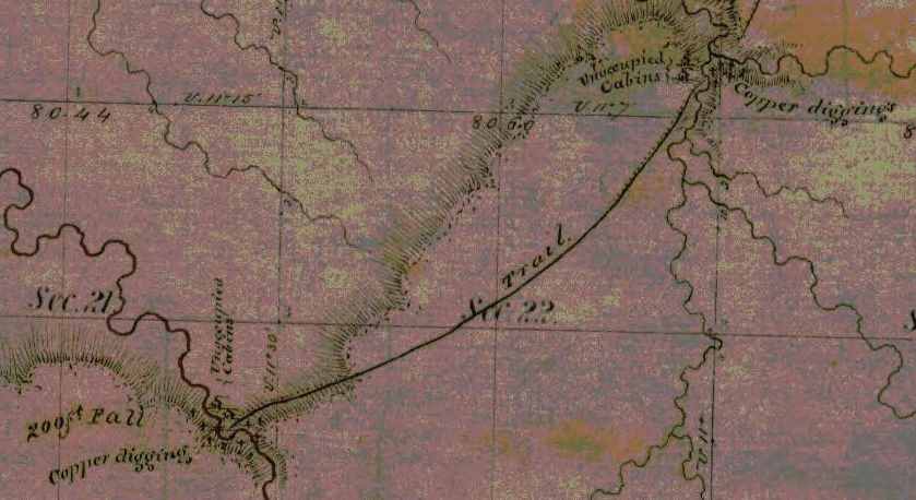
Detail from George Riley Stuntz’s original survey map of Township 47 North, Range 14 West: copper mines, abandoned cabins, and a tote road in what is now Pattison State Park. The northeast feature is Copper Creek and the southwest feature is Big Manitou Falls.
~ Wisconsin Public Land Survey Records
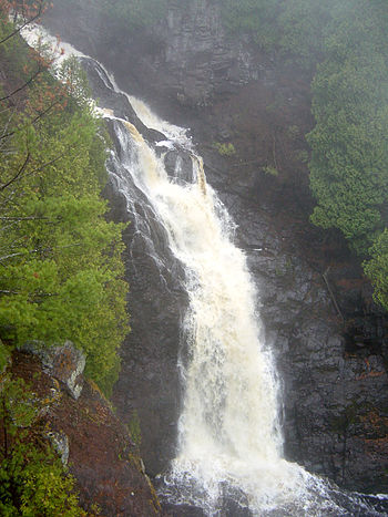
“Big Manitou Falls, the tallest waterfall in Wisconsin, in Pattison State Park just south of Superior, Wisconsin, USA.” Photograph from
Bobak Ha’Eri shared with a Creative Commons license.
The facilities furnished by Copper Creek for stamping purposes will be apparent from an inspection of the map. The town of Superior, having a good harbor, with piers and warehouses, erected by private enterprise, presents every convenience for shipping copper and obtaining supplies. Beef cattle, driven over from Minnesota, on the military road, can be purchased here much cheaper than at the Michigan mines, which are now largely supplied from this point. Pork can be advantageously procured in the same way. Another advantage is found in the price of lumber, an article for which the pineries and sawmills in this region now find a market at the lower mines. One of the finest bodies of pine in the north-west is found on the Brulé and Iron Rivers, about twenty-four miles east of this point.
With reference to the transportation between Superior and Copper Creek, it may be mentioned that, besides the wagon road (which is now available during the winter, and at no great expense can be made so at all times), the Nemadji River which, at ordinary stages of water is navigable for small boats to a point within four miles of the location, affords an additional route.
There is reason to believe that the whole country at the westerly end of Lake Superior will receive a new stimulus to its development before many years, by the opening of railroad communication with the Mississippi River, an enterprise which is becoming the absolute necessity to the interests of Minnesota. Meanwhile communication is kept open by means of the Point Douglas military road and a regular line of stages between St. Paul and Superior, which place is thus rendered accessible at all seasons.
JAMES O. SARGENT.
Boston, Dec. 8th, 1863.
—
REPORT OF EXPLORATION.
(ACCOMPANYING SPECIMENS.)
—
Superior, Oct. 17, 1863.
JAMES O. SARGENT, ESQ.
SIR : Under instructions from you, I have made a survey of the east half of the southeast quarter of Section 15, and the west half of the southwest quarter of Section 14, Township 47 north, Range 14 west, in Douglas county, Wisconsin, and have explored the same as thoroughly as the limited time and the small force under my direction would permit.
I herewithin submit a copy of the field-notes of the survey, and a map of the location.
In making the exploration I had the services of Mr. George Walker, an English miner, who has had several years’ experience in the various copper mines on this lake.
The tract is thickly timbered with spruce, fir, aspen, sugar, oak, white pine, and birch. This timber is small in size.

The Aminecon Trap Range crosses the location. This Range makes its appearance above the sandstone on the east side of Township 48 north, Range 12 west, about the middle of the township, runs in a southeasterly course across the township, and across Township 47, Range 13, Township 47, Range 14, Township 46, Range 15, and leaves Wisconsin. It is cut by the Aminecon River, Copper Creek, and Black River, and numerous small streams. Throughout the extent described it gives promise of being a productive mining district.
Two small streams unite near the centre of the location, forming Copper Creek, which runs in a northwest direction, and leaves the tract about twenty rods south of the northwest corner. Owing to the extremely dry season, this stream was lower at the time of my examination than it has been known to be in ten years; but it affords at all times abundance of water for the purposes of a mine employing steam power.
By a measurement, taken October 1st, I found the amount of water passing through it to be 58 5/10 cubic feet per minute, and this is very much below the average. In ordinary seasons the amount of fall in the stream (which is from fifty to a hundred feet within the location) would give a water power sufficient for all the purposes of a mine.
From my examination I believe that there are three veins, as represented in the map, in all of which we obtained native copper.
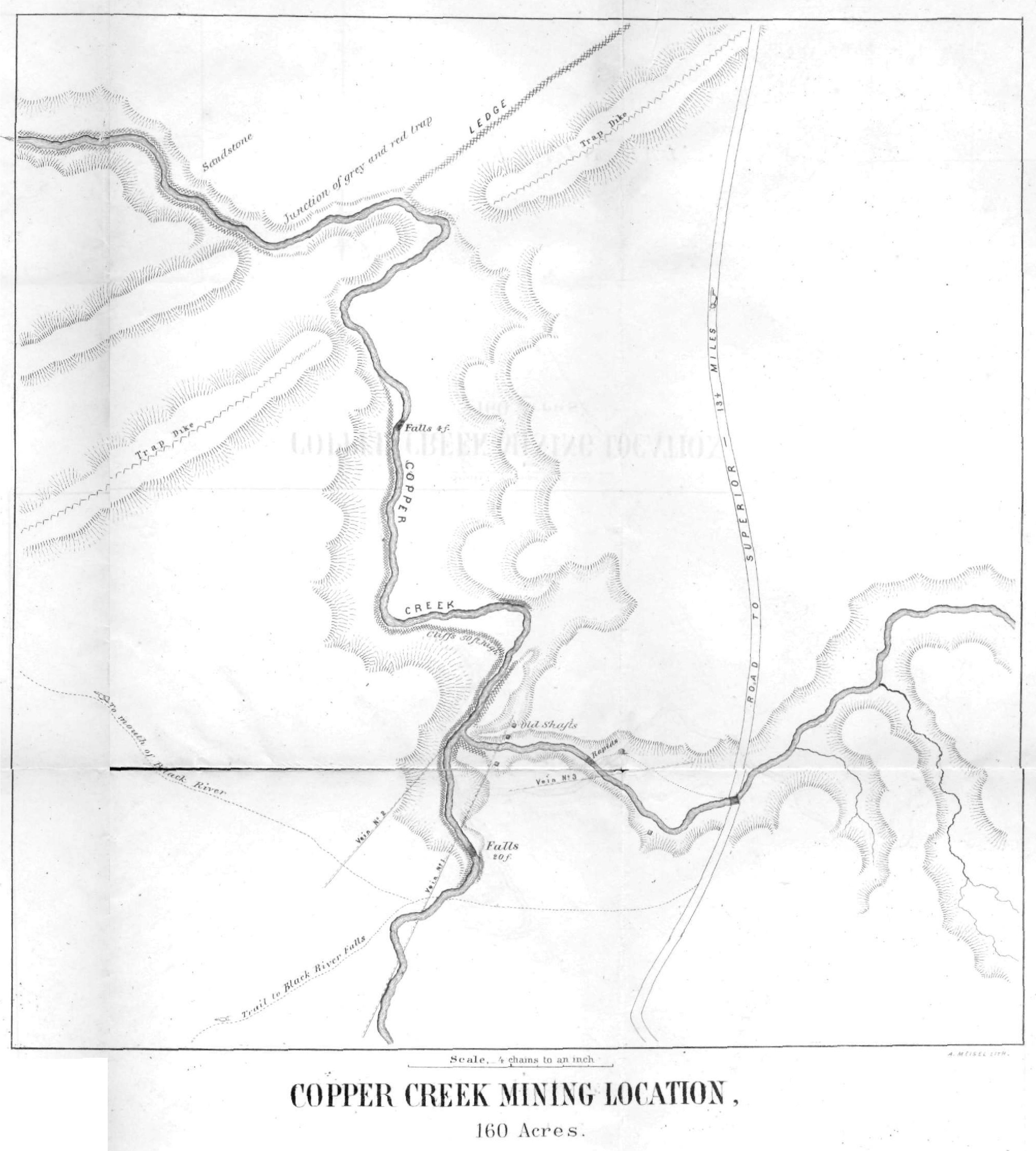
Vein No. 1 shows a breast in the east bank of the west branch of the stream, of nearly twenty feet wide, and bears south twenty-four degrees west. The specimens taken from this locality are numbered, and, as you will perceive, exhibit a quality of vein-stone which gives promise of productiveness. This vein has been traced to the southwest and adjoining location. It dips to the southeast at an angle of thirty-three degrees. The productive part of the lode lies upon the foot-wall, specimens of which I furnish with this Report, as also of the hanging wall.
Vein No. 2 shows a breast of over thirty feet in the bluff east of the stream, and appears to run in a northeast course. My explorations were not carried far enough to fully define its course in that direction. Surface specimens of the vein and of the adjacent trap are furnished herewith.
Vein No. 3 cuts the east branch of the creek, and bears north eighty-two degrees east. We opened this vein in four places at the creek, within two hundred feet. It has the appearance of being very much disturbed. On the west side of the stream, it is very compact and filled with quartz-lined cavities interspersed with crystals supposed to be malachite. It dips to the northwest. Specimens from this locality, a full collection of which is furnished, warrant a more thorough examination.
Vein No. 2, before referred to, as showing a breast of thirty feet in the east bluff, appears to branch or to be thrown out about eighty feet in crossing the creek bottom; my limited time and means did not permit me to determine which.

About two hundred feet below the junction of the two branches of the creek it shows at the foot-wall in the bed of the stream. A few feet west of this, the lode rises in the bluff on the west side of the stream. Course of stream at this point north twenty-eight degrees east. Course of vein north forty-two and one-half degrees east. At this junction of the streams, the lode, stripped of its hanging-wall, rises to the top of the cliff, a height of forty or fifty feet. At this point, we blasted into the lode, and found it rich in copper, some pieces weighing from six to fifteen pounds, and with rich stamp-work. See specimens marked Vein No. 2, west of stream.
About fifty feet above the forks of the stream the lode rests upon a bed of conglomerate. This conglomerate is highly metamorphosed, and is amygdaloidal. See specimens.
About one hundred feet west of this, we opened the vein on the brow of the hill. It there shows a breast of twenty feet, and dips to the southeast at an angle of thirty-five degrees.
~ Duluth and St. Louis County, Minnesota: Their Story and People; Volume 1, page 66.
This location was worked to some extent in the years 1846 and 1847, under a lease from the General Government, by the American Fur Company. They sunk four shafts, but appear to have done very little surface exploring.
Three of these shafts are sunk on the course of Vein No. 1, and from my examination appear to have been perpendicular. Their location is given on the map. The timbering is so much decayed that I did not venture to work in them. From soundings, I found the shaft between the streams forty-six feet deep, the next one on the east side of east branch twenty-eight feet deep, and the one east of section line twenty-eight feet deep. All of them have water to within about twelve feet of the surface. The fourth shaft is sunk at the bend of the east branch. This is thirty-five feet deep, and does not appear from the burrow to have been upon any vein.
The first three shafts above described were sunk perpendicularly upon the outcrop of a vein dipping thirty-three degrees, and therefore pass into a foot-wall. Had they been continued, they would have cut Vein No. 2. They may perhaps be made available in a further exploration.
Upon the adjoining location, to the westward, is a vein discovered by John Parry, some years ago. I have taken some specimens from it which are herewithin furnished. This vein runs north eighty-two degrees east, and intersects your western boundary six chains north of the southwest corner. It appears to be a continuation of Vein No. 3.
At the junction of the trap with the sandstone, in the northwest corner of the location, in the bed of Copper Creek, a bed of bluish-white grindstone grit of first-rate quality is found. The layers are from one inch to several inches in thickness. This white sandstone appears to belong to a different period from the red sandstone of Lake Superior. It only shows to the height of a few feet, and is overlaid by sixty feet of the red sandstone.
In the vicinity of the trap dike it is bent and fractured and considerably hardened. Near the junction, as marked on the map, it is tilted until some of the layers stand perpendicular. There are no ripple-marks on this white sandstone, while the red, resting upon it, shows evidence of a strong current.

Portrait of George Riley Stuntz from The Eye of the North-west: First Annual Report of the Statistician of Superior, Wisconsin, by Frank Abial Flower, 1890, page 26.
This tract of land is thirteen and one-half miles from the town of Superior, at the west end of Lake Superior. It is on a County Road which has been nearly completed, is now practicable for winter use, and can be made a good summer road at an expenditure not exceeding $2,000.
The soil is a sandy loam, with a subsoil of red clay containing a large per centage of marl, and is quite productive, being capable of producing a large portion of the vegetables needed by the operatives at a mine. It is especially adapted to the cultivation of grass and oats. Timber for lumber and fuel can be obtained conveniently and in unlimited quantity.
Respectfully submitted,
GEORGE R. STUNTZ,
Surveyor in charge of Exploration.
An Old-Time Trip
September 10, 2016
By Amorin Mello
This is a reproduction of “An Old-Time Trip” from Report of the Pioneer Society of the State of Michigan together with Reports of County Pioneer Societies: Volume IX, 1886, pages 108-118.
An Old-Time Trip
by F. R. Stebbins
Thirty-five years ago. These words awaken in the minds of the young people of to-day, no personal memories of the past, and have to them only the significance of a mention of the times of “long ago,” the times away back of their first look upon this fair land, the region of the great lakes.
Francis R. Stebbins was either the brother or grandson of Cortland Bliss Stebbins; an editor of The Adrian Michigan Expositor.
Our children listen to the simple story of our experiences thirty, forty and fifty years ago, with great interest, but can never realize the full import of our narratives; but to such of us as have been, during these years, the actors in this labor of moulding and working out, in fact largely creating the great material, social, and political grandeur of this fair home of ours, which we found a wilderness, these words awaken many memories. How does the mention of these years bring to our minds a flood of recollections, of the sorrows and the joys, the failures and the successes, the toils of all, and the resting from their labors of so many, who once aided us in this great work of founding a new and noble State. Now, as we look around our well furnished homes, our smiling farms, our stores, our manufactories, our schools, and school-houses, and churches, our railroads and wagon roads, the memories of the times of forty and fifty years ago seem a dream only, and a record of those times, as they pass, only a page from the romance of the novelist; and yet how that page glows and enlarges, and how even romance is dimmed by the stranger realities, as the individual experiences of those years are related in the many volumes of our pioneer collections, you all know. I have, in this paper, no strange tale to tell, no startling romance, and perhaps very little interesting reality to record; but, thinking that the incidents of a trip to our truly great lakes in 1851 might not be entirely devoid of interest, I present them on this occasion.
~ Report of the Internal Commerce of the United States for the year 1891, by S. G. Brock, Chief of the United States Bureau of Statistics, Treasury Department, appendix 1, page 19.
Early in the month of August, 1851, it was my good fortune, through the kindness of Sheldon McKnight, in company with my wife and two young daughters, to find myself and family pleasantly settled in a good stateroom on board the steamer London, one of McKnight’s line of boats, at Detroit, bound for Sault Ste. Marie, where we were to be transferred to a “propeller” of his line on Lake Superior. The charm of such a trip to these then new and wild sections of our State, for the first time, to our party, can hardly be described: but that such a tour, with quiet water on the lake, was one of pure enjoyment, I have no doubt many pioneers present, who have taken such a trip, can easily believe. The few isolated settlements, with their rude wharves, and scattered and cheaply-constructed houses along the St. Clair River, and the land on the south and west shores of Lake Huron, to our eyes gave little promise of their present beauty and population, Port Huron was just beginning to be recognized as a stopping place of a few of the lake steamers, and Lexington and Sand Beach were of no account to mariners, with Forester, Forestville, and other points, now visited by nearly all the coasting steamers, either having no existence at all, or being usually avoided as dangerous localities for steamers.
On the west shore of the lake, beyond Saginaw Bay, the wilderness was still more unbroken. Where now stands Alpena, with its thousands of population, and its great lumber and’fishing enterprises, a solitary pioneer, or fisherman’s shanty, marked the spot—the Indians having prevented all attempts of settlement—and there, as along the coast, the great pine forests came down to the water’s edge. All was unbroken wilderness, with its wealth of timber. A small and very rude settlement only at Cheboygan and Duncans.

John “Jack” Wilson was Captain of the propeller Monticello.
~ Portrait from Frank Leslie’s Illustrated Newspaper, September 22, 1860.
What a world of memories of the traditions and the romantic histories of the far-famed Mackinaw region came over us as we steamed by beautiful Bois Blanc, and came out in view of old Mackinaw, Point St. Ignace, and the gem of all, the peerless Mackinaw Island. All was new to many of our company, and save the fort and framed houses, and the rude wharf and modern vessels, instead of Indian wigwams, and the beach lined with bark canoes, much the same as when Marquette first looked upon the same scenery nearly two hundred years before. It did not detract from the interest I took in this beautiful island, when I remembered how, in my boyhood, in the old school-house spelling bees, in Vermont, so many of us used to wrestle with the old name “Michilimackinack,” and I am not sure that I can spell the word correctly even now. After a short stop we steamed away for Detour, and entered the river St. Mary. By this time our passengers became pretty well acquainted with each other, and we could call the roll for the then Governor John S. Barry, Auditor General John Swegles, John Harmon, a State senator, A. Harvie, Mr. Harris, editor of the Cleveland Herald, and we were joined at the Sault by Hon. Mr. Henry, from Vermont, and Hon. Truman Smith, U. S. Senator from Connecticut. The fact that four of us were staunch whigs, and four dyed-in-the-wool democrats, did not mar in the least our pleasant intercourse during the trip. Governor Barry, from his sedate countenance, in the early voyage, had been set down by the stranger passengers as a missionary to the Indians, on the way to join his charge, and we had to joke the governor on his missionary work, all of which he took without offense. To those of us who knew John Harmon in those days, I need not say he was not taken for an assistant missionary, although a listener might sometimes hear him exclaim, “I assist.”
May 13, 1851
“THE ‘SOO.’ – The London, Capt. Watts, came in last evening with a full freight of the commodities of Lake Superior, copper from the Cliff Mine, &c. The new steamer Monticello, of McKnight’s line, was on the ways, and the most active exertions making to launch her across the Portage to take her place along the line on Lake Superior. The London carried up 250 passengers, and considerable interest seems to be exhibited in relation to the copper mines. The Railroad across the Portage is in full operation, with all it can do. If a pleasure trip is desired, let a passage be taken on the favorite steamer London, via Mackinaw to the Sault and back. She leaves for the above places on Wednesday morning.”
June 17, 1851
“The propeller MONTICELLO has been taken over the portage—and was launched in the water of Lake Superior Monday week.”
At the ‘”Soo” we left the London and took quarters at the hotel, waiting a day or two for the arrival down of the propeller Monticello, upon which we were to take our voyage on Lake Superior. During our stop I had the pleasure of catching a string of speckled trout, in the rapids, fishing from the shore. The population of the village of Sault Ste. Marie at that time was made up largely of Chippewa Indians and French and Indian halfbreeds, and a few soldiers at the United States military post, and contained very little enterprise or trade beyond saloons, and stores for Indian supplies. There was no canal, and all transit to Lake Superior, and from the lake to the river, around the rapids, was overland about one mile, by teams, or by a tram railway, with platform cars; and the two and only steam vessels on Lake Superior had been taken over this portage from St. Mary’s river. What a contrast with to-day, when it is stated, on good authority, that the tonnage of grain, metals, ores, merchandise, etc., through the great locks at St. Mary’s, was during the last year, larger than that passing through that great world’s highway, the Suez canal. The next morning, after leaving the Sault, we were in sight of the Pictured Rocks. And who can describe the sensation of a traveler whose eyes for the first time rest upon these wonderful pictures of nature’s handiwork? And who shall describe the pictures as they appear? Weird, wonderful, beautiful is all we can exclaim. Passing Pictured Rocks, we tied up to the shore of Grand Island. Here was one house and a little clearing, where a solitary family was struggling for a living, by cultivating a few vegetables and furnishing fuel for the propellers on Lake Superior.
Gov. Barry was here taken with a fainting attack; but he was taken on board and soon recovered, and we proceeded on our way.

Peter White, circa 1860’s.
~ The Honorable Peter White: a biographical sketch of the Lake Superior iron country, by Ralph D. Williams, 1907, page 146.
Our next landing was at the present site of Marquette, then called “Carp River.” A settlement had just commenced here, but the bluff was covered with pine and spruce trees, with a few modest cabins, the whole presenting as dismal a looking pioneer beginning as one could find anywhere. A little iron ore had been quarried and smelted there, but the greatness of this industry and mineral wealth, since developed under the fostering care of protection to home industry, was not dreamed of. even by the most sanguine of the enterprising men who even then saw great things for the newly discovered mineral wealth of the Lake Superior region. Seeing Marquette, as I did then as Carp River, with no wharf, almost no settled population, a mere opening in the wilderness, I was not prepared for the wonderful change I saw when I visited it some thirty years afterwards, in the great ore docks, and an almost continuous line of cars, discharging into the boats the rich ore from Negaunee and Ishpeming, and the busy, beautiful city, with its brick blocks, costly residences and iron works, and other industries. To no one man, probably, has Marquette more reason to be grateful for her wonderful growth and prosperity, than to a member of this society, and one who has often added to its interest in recitals of accidents connected with the early settlement of the Upper Peninsula, the Hon. Peter White.
Giving Carp River a parting gun from a small cannon on our deck, we steamed away up the lake to Eagle Harbor. This was also a very small beginning of a settlement, with a few rude buildings scattered among the pine trees. Our next stop was at Eagle River. Here was no harbor and no wharf, and the steamer anchored some distance from shore, and the passengers went ashore in row boats. Here the steamer “landed” some cattle, which was done by pushing them overboard at the gangway, the cattle swimming ashore. Eagle River was the landing place for the Cliff and North American copper mines, which were located some three miles away, the road to the mines passing over a high land ridge some six or seven hundred feet in height. The Cliff mine that year was thought to have done a great work in the shipment of 1200 tons of copper. Another mine, since that, has shipped 18,000 tons in one year.
Marine Review, Volume 32, July 27, 1905, pages 44-45.
Another parting gun, and we headed direct for La Pointe. Soon after starting, we met and saluted heartily the other steamer on the lake, the propeller Manhattan, little dreaming of the coming events of our next meeting.
Our approach to La Pointe was one of great interest to many of our party, the larger part having never before visited the region of the Apostle islands.
On shore we saw the old mission house, a large trading house, a few other buildings, with a large sprinkling of Indian wigwams. From all parts of the little settlement we saw coming towards the landing a few white men, and a motley crowd of Indians, including squaws, and young and older children, all clad in Indian costume, or a mixture of Indian and white men’s clothing, the advent of a steamboat being at that time an uncommon event at La Pointe.
We were much pleased to learn that old Chief Buffalo was at home, and that a hundred or more wild Chippewas were encamped in the woods nearby, adding no little interest to our visit. We were soon all on shore, and exploring the settlement.
Of course the first objective point, for a few of us, was the Indian wigwams, made either of skins or bark, with the usual architecture of Indian skill, and the usual decoration of dirty blankets, kettles, and skins. Meanwhile the dancing portion of our party were entertaining a large party of the natives with a white man’s dance, in the trading house, which soon suggested an Indian dance; the first intimation of which I received by the arrival of the lord of a wigwam, the interior of which I was inspecting, who turned me out of his “castle,” peremptorily, with the excuse, imparted mostly by signs, that he wished to dress for the war dance. We found when we recognized the gentleman of the woods later, at the dance, that his “dressing” consisted in taking off what few clothes he usually wore, and painting his body with all manner of devices, rudely made with his several fingers for a paint brush.
We all lost no time in gathering at the mission house before which, on a wide lawn of short grass, the dance was to be held. Ere long we heard in the direction of the woods, where the wild Indians were encamped, the peculiar thump of the “tom-tom,” or Indian drum.

Detail of Benjamin Armstrong from a photograph by Matthew Brady (Minnesota Historical Society). See our Armstrong Engravings post for more information.
The excitement of the white tourists now became intense. We all knew we were to look upon a genuine war dance—all but the war—not by some mountebank company, but principally by the woods Indians, who so far had refused to be civilized and Christianized into doubtful saints, at the Jesuit mission stations. We all moved outside, and arranged on the wide platform in front of the house, which from a gentle elevation afforded a fine view of the dance ground. On one part of the platform were placed chief Buffalo, seated in the only arm chair to be found, with Governor Barry and the other dignitaries on either side of him. Chief Buffalo could only express himself through an interpreter, and he sat in stoical silence, without a movement of facial muscle during the whole dance. The rest of our party were standing on the other part of the platform, with our ladies in front, all in eager anticipation of the appearance of the Indians; and certainly not the least interested in the coming procession were our tourists who enjoyed the front seats, where nothing could obstruct a free vision of the warriors. On came the red men. First is seen the motion of the elevated staff adorned with large eagle feathers, borne by an aged warrior; next an old torn American flag; and soon, with steady tread, to the measured beatings of the Indian drum, the whole band comes in view. Now came a new sensation. The ladies had not been informed of the peculiar features of the elaborate ball dress of the Indians, and no sooner had the much-painted warriors come in sight, than the longest-sighted lady, shading her eyes with her hand for a moment, to get a better view of the details, was suddenly taken ill, and, hastily pushing our rear ranks of gentlemen asunder, she fled into the house, Nearer came the Indians, and another lady was attacked with the same disorder, and escaped inside. Thump, thump, louder sounded the tom-tom, nearer and nearer came the Indians, when another lady was attacked with the strange contagious disease, and then another, and another, quickly followed by a stampede of every lady on the platform, for which was made an open rank movement, and we, the men, were left alone on the platform to admire Indian warriors’ toilets. Now the motley band halted before us, the tom-tom ceased, and the naked loveliness of these forest dancers appeared, even to the most short-sighted beholder. Notwithstanding our great interest in the display, we could not help being anxious about our ladies, in the house, whose sudden illness was depriving them of an equal share in the entertainment. Our great regrets were uncalled for; and if we had in those earlier years of life known what riper experience has taught us, that the ladies, although timid at the start, on any great and unusual display of strange forces will always find a way to overcome the timidity, and push again to the front, and be the last to leave the conflict, our anxiety for these would have been less. And so it was on this occasion. My mind, reverting in sympathy to the unfortunate indisposition of our ladies, I naturally cast my eyes back towards the windows of the room in which they were concealed, just as the drum commenced to beat again for the grand dance; and what was my astonishment to see six distinct female faces instantly dodge back from six window panes, they were plainly and closely pressing. Soon, another fair face appeared, looking over the shoulders of the gentlemen in the doorway. The gentlemen naturally made way for the fair one to get a better view, and the lady improved the kindness. Another lady filled her place, and soon, in her turn, advanced for a better view; occupying the place of the first lady, who had now moved on nearer the front, and this movement went on by the ladies, until, in succession, as quickly, as they had been attacked by the Strange disorder, the invalids were all recovered, taking their old positions in the front, “fighting bravely until the last gun was fired,” and then complaining that the battle of the “breech-cloths” did not last longer.

John Quincy Adams “Indian Peace Medal” distributed at the 1825 Treaty at Prairie Du Chien. Buffalo was a signatory of this Treaty on behalf of the La Pointe Band.
~ Smithsonian Institute

Reverse side of “Indian Peace Medal” from the 1825 Treaty at Prairie Du Chien was reproduced from the 1801 Thomas Jefferson medal (pictured).
~ Smithsonian Institute
The warriors in this dance, as they moved around in a circle in close single file, presented a variety of dress enough to suit anyone. Very many of them had no dress, save the breech-cloth, and paint. One old warrior was dressed in a wolf skin, with the wolf head forming a head covering. Another, with spare spindle shanks, trotted around with a bright scarlet shawl on his shoulders, worn folded, with the corner points dangling at his heels. One nobly-formed savage wore, suspended on his bare breast, two large silver medals, presented by the U. S. Government in 1825, one stamped “peace and friendship,” the other, “John Quincy Adams, President of the United States.” The old men simply gave an occasional grunt, as they moved around with measured tread of spare and tawny limbs unclothed, in solemn dignity. The younger braves were profuse in grotesque postures and whoopings, barkings, wolf howlings and discharging their guns in the air. Some were dressed only in deer-skin breeches, with the usual ornaments of beads, tassels and feathers, and some had red shirts only.
After the dance the great Buffalo signified his desire to have a talk with Gov. Barry. State Senator Harvie introduced the Governor, who said: “The great chief of Michigan is glad to meet the great chief of the Chippewas. He desires to meet him as a friend and a brother, but not to confer upon political subjects. Let this meeting be one of friendship between the people of the great chief of Michigan and the people of the great chief of the Chippewas, and nothing more.” This was repeated to Buffalo in the Chippewa language, sentence by sentence, by the interpreter.
The great Buffalo replied, through the interpreter, as follows:
Buffalo was a signatory of the 1826 Treaty at Fond Du Lac:
“ARTICLE 5. In consideration of the poverty of the Chippewas, and of the sterile nature of the country they inhabit, unfit for cultivation, and almost destitute of game, and as a proof of regard on the part of the United States, it is agreed that an annuity of two thousand dollars, in money or goods, as the President may direct, shall be paid to the tribe, at the Sault St. Marie. But this annuity shall continue only during the pleasure of the Congress of the United States.”Buffalo was a signatory of the 1842 Treaty at La Pointe, which ceded the greater La Pointe region to the United States. Bagone-giizhig (Hole-In-The-Day) the Younger was the first signatory listed on this treaty. While La Pointe, Mille Lacs, and other Chippewa Bands did not recognize Bagone-giizhig as a leader, the United States did.“My father, I am glad to meet you here, on this land where my fathers lived, and the land which they have left me, and where their bones repose. Especially am I glad to meet you at this time, when on account of some things, my heart is sad. I was told I should be paid off here, in this place, twenty-five years ago; and now, before the time is half gone, I am told I must go to Sault Ste. Marie. It is a great way; I am old and cannot go. The man who sold these lands was but a child. Buffalo did not do it. My father knows the ways of the white man and the ways of the red man. In view of all this, the great Buffalo feels sad. I wish you to look at these papers.”
Here the chief took from beneath his dress a copy of a treaty with the Chippewas and handed it to the Governor, who, after looking at the title, handed the papers back to the chief, and replied:
“The chief of Michigan is only chief of another great tribe, and has no power in the matter of this treaty. He will do all in his power to promote justice and right, and he advises the great Buffalo to do as his great father, the President, directs, as he will do right.”
The same old “taffy,” as the boys now call it, always dealt out so liberally to the Indians. The “great father” at Washington no doubt “did right.” by enforcing the wrong in the bogus treaty with the “child,” of whom Buffalo spoke. As Buffalo told Gov. Barry, “he knew the ways of the white man.” I think we all know pretty well of the wrongs so many times enforced in accordance with the terms of fraudulently obtained treaties with the Indians by the government, which the wronged natives are told “always does right.”
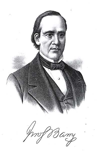
Governor John Stewart Barry
~ Commons.Wikimedia.org
The pipe of peace was then passed around, and the “talk”‘ was over. At this point John Harmon and the mercurial Senator Harvie had concluded the scheme of a little joke upon a peculiar financial characteristic of Gov. Barry. It was well known that the Governor, although wealthy, was very prudent with his means, in his expenditures of money, and it required very adroit management to open his purse strings on any common occasion. But here was a very uncommon call, and when John Harmon suggested to the Governor that it was customary in such cases to make some small present to the Indians, the Governor, thrown off his guard by the excitement of the dance, and the words small present, in Harmon’s suggestion, replied: ‘”Very well, gentlemen, make them such a present as you think suitable for me.” Harmon and Harvie sped away to the trader’s store, and the small present speedily distributed to the red men and their squaws would have insured the Governor at least six votes each from the braves had they resided in Chicago or New York at the next election. But when, just before we were to embark for our departure, the bill, to the amount of some forty or fifty dollars, was presented to the Governor, those of you who knew him can imagine the pent up wrath which his dignity, before another great chief, restrained from explosion; but it cast over his dark features a look which reminded one of a black thunder cloud which seemed just ready to burst asunder with terrific lightning and thunder. He paid the bill in portentious silence, and said not a word; but had he, about that time, caught John Harmon and Senator Harvie alone, I think I would decline to record the merited rebuke he would have given them in his well known vigorous language, when occasion called for it. The clouds of the affair hung over him a long time; and when we landed at Ontonagon, the Governor would not go ashore, for fear, I suppose, of more Indians, to receive “small presents.”
We left La Pointe with regret, having our time so much occupied by the red men that we had no time to thoroughly explore the locality where Marquette was located about 1669, when only thirty years of age.
We were obliged to anchor nearly a quarter of a mile from shore, at Ontonagon, on account of the shoal water; and a part of our company went ashore in row boats. An old barn-like warehouse, a low double log house, one or two other log cabins, and a small frame house in process of construction, was all there was of Ontonagon; and we were soon on board and steaming down the lake.
Friday, August 8, 1851
“The Lake Superior Journal gives the following particulars of the collision between the Propellers MANHATTAN and MONTICELLO:- The accident occurred at midnight, about five miles this side of White Fish Point, and thirty five miles above the Sault, the MANHATTAN being bound up, and the MONTICELLO, bound down. There was a large pleasure party on board the MONTICELLO, and many of the passengers, were up at the time and were out on deck to see the other boat pass; but by some unaccountable mistake or misapprehension of the part of one or both, they came in collision; the MONTICELLO striking the MANHATTAN on the starboard side, about midships, and cutting through the narrow guard into the hull, so far that she filled and sunk to her upper deck in less than ten minutes.
The passengers on the MANHATTAN were generally asleep, but by most wonderful good fortune they all succeeded in getting on board the MONTICELLO, and it is not known that a single person was lost or was seriously injured. The MANHATTAN had just left port on an upward trip, and had a large quantity of wood and pine lumber in her hold, and on her lower deck, which prevented her from sinking altogether. In this condition she was towed back to a small bay at the mouth of the river, where she now lies. The most of the passengers left their baggage on the lower deck, which with much valuable property was lost, or buried for the present, several feet beneath the water.
Capt. Wilson is spoken of in high terms of praise for his conduct on this occasion, in affording every accommodation in his power to the distressed crowd of passengers from the wrecked vessel.”
We made two other landings on our way back, and as the last sunset we would be able to enjoy on Lake Superior bade us a golden good night, we gathered around the cabin lights, and congratulated each other upon the unvarying beautiful weather for the entire week we had passed upon this great water; and retired to our state rooms for peaceful rest, and the landing in the morning at the Sault. It was a beautiful starlight night, and when about five miles off Whitefish point, at midnight, we were all awakened by a terrific crash, and concussion of the boat, which nearly threw us out of our berths. Such of us as were thus rudely awakened, supposed we had struck a rock. On entering the cabin from my state room, I found the floor around the dining room table strewn with broken crockery, food, and glassware, which the collision had thrown from a table where the captain and the choice spirits of the passengers were having a farewell supper; and the passengers were running to and fro in great alarm. We soon found we had come in collision with the other and opposition steamer on the lake, the Manhattan, but did not know for a short time of intense suspense if one or both steamers would go to the bottom,’which was soon found to be beyond soundings. Very soon, we heard our captain, Jack Wilson, call out to Capt. Colwell, of the other steamer, “For God’s sake hurry your passengers aboard my boat, for you are sinking.”
In the midst of intense excitement, the few men, women, and children, were hurried from the sinking Manhattan, and lifted from the small boats on board the Monticello, nearly all of them in their night clothes, barely escaping with their other garments in their hands.
We saw the doomed steamer gradually sinking deeper and deeper in the water, and waited with anxious eyes for the moment, soon expected, when she would take the final plunge. She was soon down to the upper deck, and just as we held our breath to see the water engulf her, some one cried out, “She floats!” And so it proved. The boat was heavily loaded with lumber and wood, and, just sinking to her upper deck floor, floated, from the buoyancy of the loading. We took the wreck in tow, and the next morning, within a few miles of the landing at the Sault, I saw her keel plow into the sand bottom, in twenty-two feet of water, and the rest of that season, “our line” had no opposition.
It is often very amusing, even in the midst of events full of ruin and disaster, to witness the ludicrous acts of individuals.
A lady was brought on board our boat, who sank upon the cabin floor, in her night clothes, and, clasping her hands as if in utter despair, exclaimed, “Oh, dear! my trunks are all lost, and my two new silk dresses in them, and I have been way down to Massachusetts to get them; but I don’t care if I can get my new teeth! I left two new sets in my state room, and I must have them! Do tell somebody to get my teeth before the boat sinks. If I can only get my teeth, I don’t care for anything else!” One man came through the cabin, crying out to the passengers, “Get out of the way; she has powder on board, and will explode in a minute!”
As we all knew that powder was, at that time, ten feet under water, he did not alarm us much. But it was very touching to see the mothers clasp their children in their arms, when they realized their safety, and with tears streaming down their cheeks, thank God for their deliverance from the sinking boat. There were many tearful eyes in that cabin, besides those of the rescued. Before we left the wreck aground, I went aboard and found the stem of our boat had struck the Manhattan about midship, and almost at right angle, cutting completely into her hull and deck some seven or eight feet. As a piece of naval war practice, this collision would have been a great success. But as a peaceful meeting, on the broad, deep lake, on a bright, starlit night, I suppose the courts must have decided on its merits. I never learned the subsequent fate of the Manhattan.
We found the London at the wharf, below the St. Mary’s Rapids, and the tram railway soon transferred us to the new quarters on board. We took a direct course for Detroit from Mackinaw, in the face of a strong wind; and the next morning, when somewhere off Thunder Bay, it was blowing a gale, and the waves made our boat groan in every joint. The captain very prudently put about and made for Presque Isle harbor, where we remained all day, until the storm subsided. There was one board dwelling house at Presque Isle, and the old unbroken forest came down to the lake shore.
A pleasant ride down to Lake Huron, and we entered the River St. Clair, at Fort Gratiot, in the afternoon, well contented to enjoy the beautiful quiet waters of the river, after the somewhat uncertain waters of the lake; and at night we went to our state room for our last sleep on the steamer, before we should again walk the streets of Detroit, with its already known dignity as a city, and rejoicing that on our now fast closing tour we had safely escaped all the perils of collisions, the wild Indians, and wilder waves of the great lakes. But events proved it is not judicious to balance your books before your accounts are all posted. In my berth that night, while quietly enjoying the steady movement of our boat in the still water, I heard a low grating sound coming up from the bottom of the boat, and by a little attention soon discovered it was the keel of the boat scraping acquaintance with the gravel of the shoals in Lake St. Clair, and I was rather enjoying the novel entertainment, when, all at once, there came a crash below our room that shook the boat as if a torpedo had been exploded under us.
You may well believe the satisfaction I felt, at that moment, in the knowledge that the solid earth was not six inches below our boat’s keel was of no little magnitude, and as the wheels soon began to move, and the boat evidently was again on her course, we kept our berths, and slept until morning, counting two collisions on one trip of no small importance in the list of our adventures, for we found, in the morning, we had collided with the bowsprit of a large schooner, breaking it off, and it in return completely wrecking the cook room and pantry of the steamer.
The pleasant memories of that two weeks’ trip to Lake Superior, in 1851, are green in my memory yet; but with them is mingled the sad reflection that of the twelve persons of our party mentioned in this paper, only three remain, John Harmon, my oldest daughter, Mrs. Colvin, of Adrian, and myself. Oh how our pathway through the departed years is shaded by the many willows we have planted along the way, over the graves of our friends and loved companions. Fellow pioneers, our turn to stop and rest, as these have done, is not far away. May our lives be such that when it comes, kind hands may plant the cypress and the willow over our resting places with the same sincere regard we have cherished for the dear ones who have gone before us. On through the coming years we seem to see the unclouded brightness of the pathway, for those who shall fill our places; but let our children remember that an unbroken line of the cypress and the willow will follow them, as it has followed us, as the years move on, until we all gather on that shore, where there can be no shadows, because there is no sun; “for the Lord our God is the light thereof.”
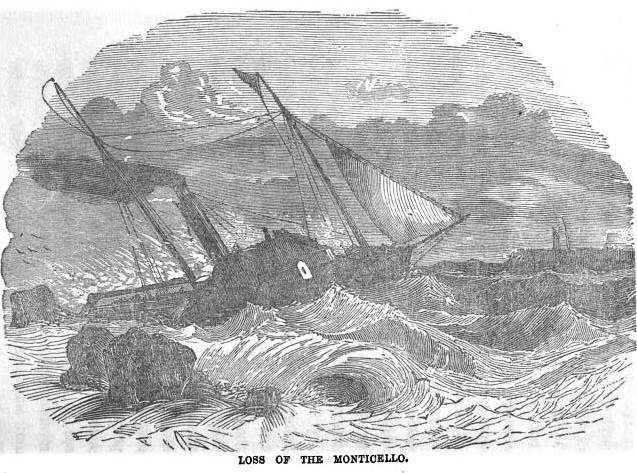
The Monticello also sank a few weeks later circa September 25th, 1851. Portrait from “Shipwreck of the Monticello” from Thrilling Adventures by Land and Sea, by James O. Brayman, 1852, pages 292-304.
Martin Beaser
August 9, 2016
By Amorin Mello
Magazine of Western History Illustrated
November 1888
as republished in
Magazine of Western History: Volume IX, No.1, pages 24-27.
Martin Beaser.

Portrait of Martin Beaser on page 24.
On the fifth day of July 1854, Asaph Whittlesey and George Kilborn left La Pointe, in a row-boat, with the design of finding a “town site” on some available point near the “head of the bay.” At five o’clock P.M. of the same day they landed at the westerly limit of the present town site of Ashland. As Mr. Whittlesey stepped ashore, Mr. Kilborn exclaimed, “Here is the place for a big city!” and handing his companion an axe, he added, “I want you to have the honor of cutting the first tree in a way of a settlement upon the town site.” And the tree thus felled formed one of the foundation logs in the first building in the place. Such is the statement which has found its way into print as to the beginning of Ashland. But the same account adds: “Many new-comers arrived during the first few years after the settlement; among them Martin Beaser, who located permanently in Ashland in 1856, and was one of its founders.”1 How this was will soon be explained.
The father of the subject of this sketch, John Baptiste Beaser, was a native of Switzerland, educated as a priest, but never took orders. He came to America, reaching Philadelphia about the year 1812, where he married Margaret McLeod. They then moved to Buffalo, in one of the suburbs of which, called Williamsville, their son Martin was born, on the twenty-seventh of October, 1822. The boy received his early education in the common schools of the place, when, at the age of fourteen, he went on a whaling voyage, sailing from New Bedford, Massachusetts. His voyage lasted four years; his second voyage, three years; the last of which was made in the whaleship Rosseau, which is still afloat, the oldest of its class in America.
The young man went out as boat-steerer on his second voyage, returning as third mate. During his leisure time on shipboard and the interval between the two voyages, he spent in studying the science of navigation, which he successfully mastered. On his return from his fourth years’ cruise in the Pacific and Indian oceans, he was offered the position of second mate on a new ship then nearing completion and which would be ready to sail in about sixty days. He accepted the offer. They would notify him when the ship was ready, and he would in the meantime visit his mother, then a widow, residing in Buffalo. Accordingly, after an absence of seven years, he returned to his native city, spending the time in renewing old acquaintances and relating the varied experience of a whaler’s life. He had rare conversational powers, holding his listeners spell-bound at the recital of some thrilling adventure. A journal kept by him during his voyages and now in the possession of his family, abounds in hair-breadth escapes from savages on the shores of some of the South sea islands and the perils of whale-fishing, of which he had many narrow escapes. The time passed quickly, and he anxiously awaited the summons to join his ship. Leaving the city for a day the expected letter came, but was carefully concealed by his mother until after the ship had sailed, thus entirely changing the future of his life.
“… Martin, a sailor just from the whaling grounds of the Northwest Coast …”
Disappointed in his aspirations to command a ship in the near future, as he had reasons to hope from the rapid promotions he had already received – from a boy before the mast to mate of a ship in two voyages – and yielding to his mother’s wish not to leave home again, he engaged in sailing on Lake Erie from Buffalo to Detroit until 1847, when he went in the interest of a company in the latter city to Lake Superior for the purpose of exploring the copper ranges in the northern peninsula of Michigan. He coasted from Sault Ste. Marie to Ontonagon in a bateau. Remaining in the employ of the company about a year, he then engaged in a general forwarding and commission business for himself.
“Algonquin Company of Detroit.”
~ Reports of Wm. A. Burt and Bela Hubbard, by T. W. Bristol, 1846, page 97.
~ A History of the Northern Peninsula of Michigan and Its People: Volume 1, by Alvah Littlefield Sawyer, 1911, page 222.
Mr. Beaser was largely identified with the early mining interests of Ontonagon county, being instrumental in opening up and developing some of the best mines in that district.
In 1848 he was married in Cattaraugus county, New York, in the town of Perrysburgh, to Laura Antionette Bebee. The husband and wife the next spring went west, going to Ontonagon by way of Detroit. The trip from buffalo lasted from the first day of May to the sixth of June, they being detained at the “Soo” two weeks on account of the changing of the schooner Napoleon into a propeller, in which vessel, after a voyage of six days, they reached Ontonagon.
Here Mr. Beaser resided for seven years in the same business of forwarding and commission, furnishing frequently powder and candles to the miners by the ton. He was a portion of the this time associated with Thomas B. Hanna, formerly of Ohio. They then sold out their interest – Mr. Beaser going in company with Augustus Coburn and Edward Sayles to Superior, at the head of the lake, taking a small boat with them and Indian guides. Thus equipped they explored the region of Duluth, going up the Brule and St. Louis rivers. They then returned to La Pointe, going up Chaquamegon bay; and having their attention called to the site of what is now Ashland, on account of what seemed to be its favorable geographical position. As there had been some talk of the feasibility of connecting the Mississippi river and Lake Superior by a ship canal, it was suggested to them that this point would be a good one for its eastern terminus. Another circumstance which struck them was the contiguity of the Penokee iron range. This was in 1853. The company then returned to Ontonagon.
Closing up his business at the latter place, Mr. Beaser decided to return to the bay of Chaquamegon to look up and locate the town site on its southern shore. In the summer of 1854, on arriving there, he found Mr. Whittlesey and Mr. Kilborn on the ground. He then made arrangement with them by which he (Mr. Beaser) was to enter the land, which he did at Superior, where the land office was then located for that section. The contract between the three was, that Mr. Whittlesey and Mr. Kilborn were to receive each an eighth interest in the land, while the residue was to go to Mr. Beaser. The patent for the land was issued to Schuyler Goff, as county Judge of La Pointe county, Wisconsin, who was the trustee for the three men, under the law then governing the location of town sites.
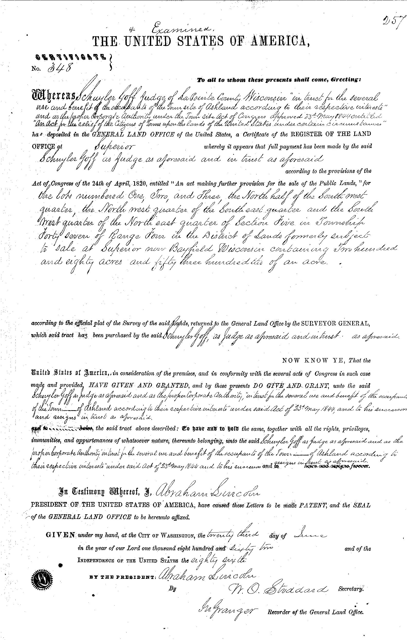
La Pointe County Judge Schuyler Goff was issued this patent for 280.53 acres on June 23rd, 1862, on behalf of Martin Beaser, Asaph Whittlesey, and George Kilburn.
~ General Land Office Records
Mr. Beaser afterwards got his deed from the judge to his three-quarters’ interest in the site.

Beaser named Ashland in honor of the Henry Clay Estate in Kentucky.
~ National Park Service
In January, 1854, Mr. Beaser having previously engaged a topographical engineer, G.L. Brunschweiler, the two, with a dog train and two Indians, made the journey from Ontonagon to the proposed town site, where Mr. Brunschweiler surveyed and platted2 a town on the land of the men before spoken of as parties in interest, to which town Mr. Beaser gave the name of Ashland. These three men, therefore, were the founders of Ashland, although afterwards various additions were made to it.
Mr. Beaser did not bring his family to Ashland until the eighth of September, 1856. He engaged in the mercantile business there until the war broke out, and was drowned in the bay while attempting to come from Bayfield to Ashland in an open boat, during a storm, on the fourth of November, 1866. He was buried on Madeline island at La Pointe. He was “closely identified with enterprises tending to open up the country; was wealthy and expended freely; was a man of fine discretion and good, common sense.” He was never discouraged as to Ashland’s future prosperity.
The children of Mr. Beaser, three in number, are all living: Margaret Elizabeth, wife of James A. Croser of Menominee, Michigan; Percy McLeod, now of Ashland; and Harry Hamlin, also of Ashland, residing with his mother, now Mrs. Wilson, an intelligent and very estimable lady.
1 See ‘History of Northern Wisconsin,’ p. 67.
2 The date of the platting of Ashland by Brunschweiler is taken from the original plat in the possession of the recorder of Ashland county, Wisconsin.
Samuel Stuart Vaughn
August 8, 2016
By Amorin Mello
Magazine of Western History Illustrated
November 1888
as republished in
Magazine of Western History: Volume IX, No. 1, pages 17-21.
Samuel Stuart Vaughn.
Portrait of Samuel Stuart Vaughn on page 16.
Of the pioneers upon the southern shores of Lake Superior, none stand higher in the memory of those now living there than Samuel Stuart Vaughn. He was born at Berea, Cuyahoga county, Ohio, on the second of September, 1830. His parents were Ephraim Vaughn and Eunice Stewart Vaughn. Samuel was the youngest in a family of five children – two daughters and three sons. Although at a very early age possessed of a great desire for an education, he was, to a large extent, denied the advantages of schools, owing to the fact that his father was in straitened circumstances financially. It is related of the boy Samuel that he picked up chestnuts at one time, and took them into Cleveland, where he disposed of them to purchase a geography [book?] he wanted. Three months was the whole extent of his time passed in the common schools of his native place – surely a brief period, and one sorely regretted for its brevity by a boy who, even then, hungered and thirsted for knowledge.
~ FindAGrave.com
In 1849 the young man came to Eagle River, Michigan, where he engaged himself to his brother as clerk. He remained there until 1852, when the brothers removed to La Pointe, Wisconsin, reaching that place on the fourth of August. He now opened a store, and engaged in trading with the Indians and fishermen of the island and surrounding country. La Pointe was then the county seat of a county of the same name in Wisconsin, and a place of considerable importance, though its glory has since departed.

Vaughn advertisement from the August 22nd, 1857, issue of the Bayfield Mercury newspaper.
~ NewspaperArchive.com
Young Vaughn spoke the French and Chippewa languages fluently. This accomplishment was absolutely necessary, in the early days of this region of country to make a man successful as a trader. He was very fond of reading, particularly works of history, and through all his pioneer life his books were his loved companions. His taste was not for worthless books, but for those of an improving character; hence he received a large amount of benefit from his silent teachers.
In his relation with the Indians, which, owing to the nature of his business, were quite intimate, Mr. Vaughn commanded their fullest confidence. It is related that when at one time there were rumors of trouble between the white people and the Chippewas, and many of the settlers became frightened and feared they would be murdered by the natives, a delegation of chiefs came to him and said they wanted to have a talk. They said they had heard of the fears of the whites, but assured him there was nothing to be afraid of; the Indians would do no harm, “for,” said they, “we know that the soldiers of the white man are like the sands of the sea in numbers, and if we make any trouble they will come and overpower us.” Mr. Vaughn was abundantly satisfied of their sincerity as well as of their peaceful disposition, and he soon quieted the fears of the settlers.
“Being impressed,” says a writer who knew him well,
“with the future possibilities of this country and ambitious, to use a favorite expression of his own, to become ‘a man among men,’ he recognized the disadvantage under which he labored from the limited educational advantages he had enjoyed in his youth, and his first earnings were devoted to remedying his deficiency in this respect. Closing his business at La Pointe, he returned to his native state, where a year was spent in preparatory studies, which were pursued with a full realization of their importance to his future career. He spent several months in Cleveland acquiring a ‘business education.’ He became a systematic bookkeeper, careful in his transactions and persevering in his plans. Having devoted as much time to the special course of instruction marked out by him as his limited means would afford, he returned to La Pointe, at that time the only white settlement in all this region, where he remained until 1856.” 1
Mr. Vaughn, during the year just named, removed to Bayfield, the town site having been previously surveyed and platted. It was opposite La Pointe on the mainland, and is now the county-seat of Bayfield county, Wisconsin. There he erected the first stone building,2 built also a saw-mill, and engaged in the sale of general merchandise and in the manufacture of lumber. “In his characteristic manner,” says the writer just quoted,
“of doing with all his might whatever his hands found to do, he at once took a leading position in all matters of private and public interest which go to the building up of a prosperous community.”
Mr. Vaughn built what is known as Vaughn’s dock in Bayfield, and remained in that town until 1872. Meanwhile, he was married in Solon, Ohio, to Emeline Eliza Patrick. This event took place on the twenty-second of December, 1864. After spending a few months among friends in Ohio, he brought his wife west to share his frontier life. The wedding journey was made in February, 1865, the two going first to St. Paul; thence they journeyed to Bayfield by sleigh, “partly over logging roads, and partly over no road.” It was a novel experience to the bride, but one which she had no desire to shrink from. She was not the wife to be made unhappy by ordinary difficulties.
As early as the twenty-fifth of October, 1856, Mr. Vaughn had preëmpted one hundred and sixty acres of land, afterwards known as “Vaughn’s division of Ashland.” He was one of the leading spirits in the projection of the old St. Croix & Lake Superior railroad, and contributed liberally of his time and money in making the preliminary organizations and surveys. Being convinced, from the natural location of Ashland, that it would become in the future a place of importance, was the reason which induced him to preëmpt the land there, of which mention has just been made.

Vaughn was issued his patent to 40 acres in Ashland on June 1st, 1859. The other 120 acres of his preemption are not accounted for in these records.
~ General Land Office Records
As may be presumed, Mr. Vaughn omitted no opportunity of calling the attention of capitalists to the necessity of railroad facilities for northern Wisconsin. He became identified with the early enterprises organized for the purpose of building a trunk line from the southern and central portions of the state to Lake Superior, and was for many years a director in the old “Winnebago & Lake Superior” and “Portage & Lake Superior” Railroad companies, which, after many trials and tribulations, were consolidated, resulting in the building of the pioneer road – the Wisconsin Central.

The Vaughn Building
~ The Northwest Magazine, October 1890, page 18.
In 1871, upon the completion of the survey of the Wisconsin Central railroad, he proceeded to lay out his portion of the town of Ashland, and made arrangements for the transfer of his business thither from Bayfield. During the next year he made extensive improvements to his new home; these included the building of a residence, the erection of a store, also (in company with Mr. Charles Fisher) of a commercial dock. The Wisconsin Central railroad had begun work at the bay (Chaquamegon); and, at this time, many settlers were coming in. In the fall he moved into his new house, becoming, with his wife, a permanent resident of Ashland.
Mr. Vaughn and his partner just named received at their dock large quantities of merchandise by lake, and they took heavy contracts to furnish supplies to the railroad before mentioned. In the fall of 1872 they established branch stores at Silver creek and White river to furnish railroad men with supplies. They also had contracts to get out all the ties used by the railroad between Ashland and Penokee. In 1875 the firm was dissolved, and Mr. Vaughn continued in business until 1881, when he sold out, but continued to handle coal and other merchandise at his dock. In the winter previous he put in 10,000,000 feet of logs.
Mr. Vaughn represented the counties of Ashland, Barren, Bayfield, Burnett, Douglas and Polk in the thirty-fourth regular session of the Wisconsin legislature, being a member of the assembly for the year 1871. These counties, according to the Federal census of the year previous, contained a population of 6,365. His majority in the district over Issac I. Moore, Democrat, was 398. Mr. Vaughn was in politics a Republican. Previous to this time he had been postmaster for four years at Bayfield. He was several times called to the charge of town and county affairs as chairman of the board of supervisors, and in every station was faithful, as well as equal, to his trust; but he was never ambitious for political honors. He died at his home in Ashland of pneumonia, on the twenty-ninth day of January, 1886.

Ashland – Residence of Mrs. E. Vaughn.
~ The Northwest Magazine, October 1890, page 20.
Mr. Vaughn was one of the most prominent men in northern Wisconsin, and one of the wealthiest citizens of Ashland at the time of his decease. He had accumulated a large amount of real estate in Ashland and Bayfield, and held heavy iron interests in the Gogebic district; but, at the same time, he was a man of charitable nature, being a member of several charitable orders and societies. He was a member of Ashland Lodge, I.O.O.F., and one of its foremost promoters and supporters. Mr. Vaughn was also a Mason, being a member of Wisconsin Consistory, Chippewa Commandery, K.T., Ashland Chapter, R.A.M., and Ancient Landmark Lodge, F. and A.M.
Although an unostentatious man, Mr. Vaughn was possessed of much public spirit, and the remark had been common in Ashland since his death, by those who knew him best, that the city had lost its best man. Certain it is that he was possessed of great enterprise, and was always ready with his means to help forward any scheme that he saw would benefit the community in which he lived. It had long been one of his settled determinations to appropriate part of his wealth to the establishment of a free library in Ashland. So it was that before his death the site had been chosen by him for the building, and a plan of the institution formulated in his mind, intending soon to make a reality of his day-dreams concerning this undertaking; but death cut short his plans.

Vaughn Memorial Library
~ The Northwest Magazine, October 1890, page 18.
It is needless to say to those who know to whom was confided the whole subject of the “Vaughn Library,” that it has not been allowed to die out. In his will Mr. Vaughn left hall his property to his wife, and she nobly came forward to make his known desires with regard to the institution a fixed fact. The corner-stone of the building for the library was laid, with imposing ceremonies, on the fourteenth of July, 1887, and a large number of books will soon be purchased to fill the shelves now nearly ready for them. It will be, in the broadest sense, a public library – free to all; and will surely become a lasting and proud monument to its generous founder, Samuel Stewart Vaughn. She who was left to carry out the noble schemes planned by the subject of this sketch, now the wife of the Rev. Angus Mackinnon, deserves particular mention in this connection. She is a lady of marked characteristics, all of which go to her praise. Soon after reaching her home in the west she taught some of the Bayfield Indians to read and write; and from that time to the present, has proved herself in many ways of sterling worth to northern Wisconsin.
Mrs. Emeline Vaughn
~ The Northwest Magazine, October 1890, page 19.
“Years ago, when Ashland consisted of a few log houses and a half dozen stores – before there was even a rail through the woods that lead to civilization many miles away – this lady was a member of ‘Literary,’ organized by a half-dozen progressive young people; and in a paper which she then read on ‘The Future of Ashland,’ she predicted nearly everything about the growth of the place that has taken place during the past few years – the development of the iron mines, railroads, iron furnaces, water-works, paved streets, and, to a dot, the present limits of its thoroughfares. She is a representative Ashland lady.”
1 Samuel S. Fifield in the Ashland Press of February 6, 1886.
2 This was the second house in the place.
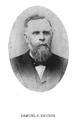
Another biographical sketch and this portrait of Samuel Stuart Vaughn are available on pages 80-81 of Commemorative Biographical Record of the Upper Lake Region by J.H. Beers & Co., 1905.
Edwin Ellis, M.D.
August 7, 2016
By Amorin Mello
Magazine of Western History Illustrated
November 1888
as republished in
Magazine of Western History: Volume IX, No.1, pages 21-24.
Edwin Ellis.
Portrait of Edwin Ellis, M.D. on page 20.
The subject of this sketch is a native of New England, and one of the “Oxford Bears,” having been in Peru, Oxford county, Maine, in 1824. His birthplace was on the banks of the Androscoggin river, among the mountains, a wild, romantic place. His ancestors came early from England to the Massachusetts colony, about the middle of the seventeenth century.
His maternal grandfather was in the Revolutionary army, and to the end of a long life was intensely patriotic and American in all his acts and thoughts. He bought one hundred and sixty acres of government land at the close of the War of the Revolution, on which he lived for more than seventy years, until his death. It still remains in the family. There were no roads in his neighborhood; and at first he was obliged to carry his corn and wheat to mill, for more than thirty miles, upon his shoulders and by a “spotted line.” He lived to break the ground for a railroad to his town and to see its completion.
Dr. Ellis received his early education in the New England common school, whose term was not more than three months in the year. At the age of fourteen years he began the study of Latin at home, going for occasional recitations to one of the celebrated Abbot family, who was a farmer in the town, some four miles distant. He was inclined to study the law, but his mother, who was a most conscientious woman, thought an honest lawyer could not live by his calling, often repeating to him this couplet –
“If I turn lawyer, I must lie and cheat,
For honest lawyers have no bread to eat.”
This had some influence upon him, and he chose the profession of medicine. He entered Waterville college (now Cobly university) in 1842, pursuing its first year’s course, when he began the study of medicine, teaching school in winter to raise money enough to pay his expenses, in which he was cheerfully assisted by his father to the extent of his means, which were very limited, he being a house carpenter and receiving the usual wages of those days of one dollar to one dollar and fifty cents per day.
Edwin Ellis graduated in medicine at the University of the city of New York, in March, 1846, being nearly twenty-two years of age. He at first settled at North New Portland, Maine. It was a frontier town, and the roads in such condition that he was obliged to travel on horseback, going sometimes forty miles in the night.
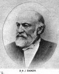
Brother-in-law Daniel A. J. Baker
~ The Eye of the North-west, pg. 9.
At the end of a year he settled in Farmington, Maine, where he had studied his profession, where, in 1847, he was married to Sophia S. Davis, who lived less than two years, leaving a daughter, Sophia Augusta, who married George H. Kennedy, who now lives at Ashland.
Dr. Ellis married Martha B. Baker of New Sharon, Maine, in 1850, a woman who has been a faithful and efficient wife for almost forty years. By her he has three children – Domelia, married to George C. Loranger of Calumet, Michigan; Edwin H., bookkeeper in the First National Bank of Ashland, and J. Scott, engaged in wood and coal at Ashland.
Dr. Ellis continued the practice of his profession in Maine, till 1854, with an increasing practice and fair prospects.
~ Minnesota Historical Society Collections: Volume XV, page 832.
But the west was then attracting much attention and the tide of emigration flowing with a strong current. His wife’s brother, Judge Baker of St. Paul, and been for several years in St. Paul, and his representations and inducements led him to sever his pleasant relations with the east and try his fortunes in the west. He with his family, wife and two children, reached St. Paul early in May, 1854. That year he carried on a farm where Merriam park now is, but he was not at home in this business, and abandoned it in the fall of that year.
The years 1852 to 1857 were years of great speculation throughout the northwest. Towns and cities, at least on paper, were springing up with marvelous rapidity. Men became, or seemed to become, suddenly rich by the rapid rise of farming lands and city lots. It was an era of strange speculation, demoralizing in its effects and leading to the terrible panic of 1857.
!["In 1845 [Warren Lewis] was appointed Register of the United States Land Office at Dubuque. In 1853 he was appointed by President Pierce Surveyor-General for Iowa, Wisconsin and Minnesota and at the expiration of his term was reappointed by President Buchanan." ~ The Iowa Legislature](https://chequamegonhistory.com/wp-content/uploads/2015/10/warner-lewis.jpg)
“In 1845 [Warren Lewis] was appointed Register of the United States Land Office at Dubuque. In 1853 he was appointed by President Pierce Surveyor-General for Iowa, Wisconsin and Minnesota and at the expiration of his term was reappointed by President Buchanan.”
~ The Iowa Legislature

Ellis was issued his title to 125.72 acres of land in Ashland on July 15th, 1858.
~ General Land Office Records

Downtown in Saint Paul during the financial panic of 1857.
~ Minnesota Historical Society
![Leonard Hemenway Wheeler ~ Unnamed Wisconsin by [????]](https://chequamegonhistory.com/wp-content/uploads/2016/03/leonard-hemenway-wheeler-from-unnamed-wisconsin.jpg)
Leonard Hemenway Wheeler
~ Unnamed Wisconsin, by John Nelson Davidson, 1895.
In 1877 he was appointed as county judge of Ashland county, by Governor Smith, to which he has been twice re-elected by his fellow-citizens. He is president of the First National Bank of Ashland. He has retired from the general practice of his profession, but is one of the surgeons of St. Joseph’s hospital, which he visits an hour each day. He is still active and deeply interested in all that concerns Ashland; has aided in securing the Holly system of water-works, the gas and electric works and the street railway. He is a firm believer in the Christian religion and in a personal God, whose guiding hand he recognizes in all the events of his life, and to whom he owes everything and to whom he desires to honor in all his journey of life, and is still alive to all efforts designed to improve and elevate the condition of his fellow-men.
Edwin Ellis, M.D., died in Ashland on May 3rd, 1903. This portrait and a posthumous biography of Dr. Ellis are available on pages 16-18 of Commemorative Biographical Record of the Upper Lake Region by J.H. Beers & Co., 1905.
Early Trails and Water Routes
August 3, 2016
By Amorin Mello

United States. Works Progress Administration:
Chippewa Indian Historical Project Records 1936-1942
(Northland Micro 5; Micro 532)
Abstract
“Records of a WPA project to collect Chippewa Indian folklore sponsored by the Great Lakes Indian Agency and directed by Sister M. Macaria Murphy of St. Mary’s Indian School, Odanah, Wisconsin. Included are narrative and statistical reports, interview outlines, and operational records; and essays concerning Chippewa religious beliefs and rituals, food, liquor, transportation, trade, clothing, games and dances, and history. Also includes copies of materials from the John A. Bardon collection concerning the Superior, Wisconsin region, La Pointe baptismal records, the family tree of Qui-ka-ba-no-kwe, and artwork of Peter Whitebird.”
Reel 1, Envelope 2, Item 1
Editor’s Note: This article is the result of the information given by the staff, also gleanings from the “Bardon Collection.”
EARLY TRAILS AND WATER ROUTES
~ Fifty Years in the Northwest, by W. H. C. Folsom, 1888, page 258.
Bardon in his Collections says, “From the earliest times, the waterways were the Red Man’s highways: naturally the fur-trader, explorer, and missionary followed the same routes.”
For hundreds of years before the white man came to live in this country, the Indians rarely traveled on land except to portage their canoes in taking short cuts from one body of water to another, thus cutting off considerable distance for extensive traveling. Then, too, game was plentiful on the banks of rivers and lakes. For these reasons the Indian preferred traveling by water to that of land.
For the white man in the early 50’s as well as for the Indian, transportation could be carried on only by water in the lowlands and by trails in the uplands, therefore, canoes were extensively used in the former and quite commonly employed in the latter, for the highlands, too, and their lakes and streams.
Water Routes
An important route connecting the Great Lakes and the Mississippi was by way of the Brule and the St. Croix Rivers. This water route began at Lake Superior, ascended the Brule River to Lake St. Croix then descended the St. Croix River to the Mississippi. The first eastern settler, missionaries, explorers, traders and Indians used this route very extensively.
Another route connecting Lake Superior and the Mississippi River was made by the historian, Schoolcraft, over a hundred years ago. This historic water route began at Chequamegon Bay, ascended the Bad River, and descended the Namekagon and the St. Croix Rivers to the Mississippi.
A route by way of Fish Creek from Chequamegon Bay was also important. Indian travelers portaged their canoes from Fish Creek to White River and down this river for several miles and again portaged to Lake Namakagon, from thence to Namakagon River, thence to the St. Croix and down to the Mississippi. This same route could be taken to the Flambeau and the Wisconsin Rivers by going upstream on the St. Croix.
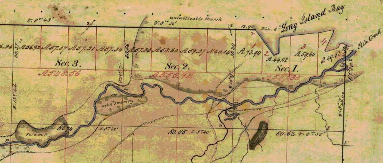
Several trails converged at the mouth of Fish Creek on Chequamegon Bay. ~ Wisconsin Public Land Survey Records
Trails
In traveling by trail most Indians traveled on foot, but many used dog-teams and toboggans, and in some cases, ponies. The Lake Superior region was a permanent camping ground for the Chippewa. This country for many miles around, and numerous trails branching off in all directions, far too many for us to mention each individually. Here we shall point out only the more important ones.
Talking Trail
“Talking Trail”, was so named on account of its beginning at a popular meeting or camping site situated where the city of Washburn now stands. “Talking Trail” began at this camping ground, thence it extended south, to Fish Creek, then south-west for a few miles, finally west to Superior, thus connecting Chequamegon Bay and Superior.
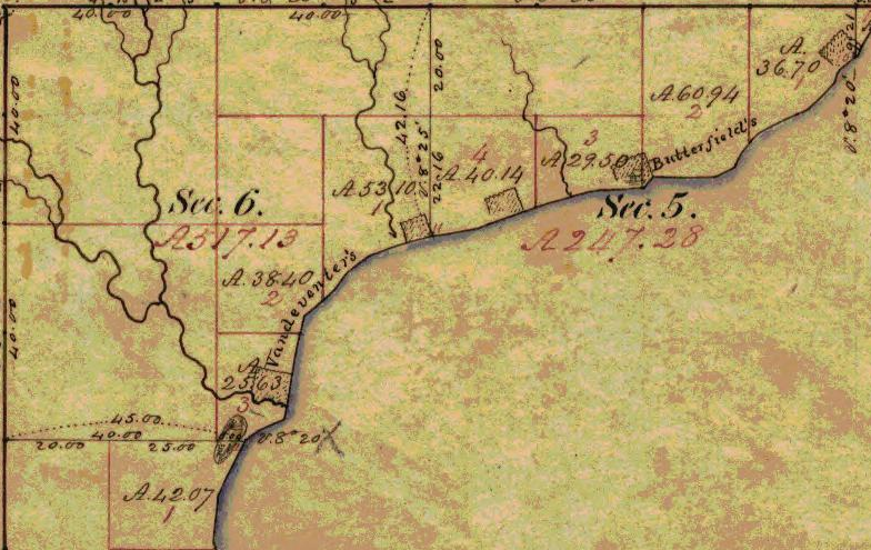
The “Talking Trail” began at the mouth of Vanderventer Creek near Washburn, and was also known as the “Council Trail.”
~ Wisconsin Public Land Survey Records
Bad River Trail
Whether or not this old trail was specifically known as designated above, the title is quite appropriate, since it began at the Leihy Mill on Bad River, Odanah, ran south to Tyler’s Forks, thence to Lake Namakagon and on to Lac Court Oreilles Reservation.
Indian War Trail
The reason for this name is evident: This trail was much used by the Chippewa in time of strife with the Sioux. The War Trail ran east to Montreal River and on to Porcupine Mountains, then to Ontonagon, thence to the copper country, including L’Anse and Marquette, Michigan. Mrs. Frank La Fernier of the Bad River Reservation, (1937) whose father, Mr. James lived to the age of one hundred-three years, corroborated this statement. Mr. James carried United States mail over this trail from our section of the country.
Moccasin Mike Trail

Chief Joseph Ozaagii was a cosigner of the 1854 Treaty at La Pointe on behalf of the Fond Du Lac Band.
~ Geni.com
“Moccasin Mike Trail”, was only another name for the “Osaugee1 Trail”. It was one of the most historic trails, and was evidently named after the local chief, Osaugee, who was the father-in-law of Charles Lord, a latter resident of Solon Springs, but originally a pioneer Quebec trader and voyageur.
This famous trail extended from the south of the St. Louis River, down Wisconsin Pointe, thence along the southern shore of Lake Superior to La Pointe, Bayfield, Ashland, Ontonagon, and the “Copper Country” of Michigan.
A branch of this trail led south, along the Montreal River to central Wisconsin, and was the route of the fur trader from Lake Superior to Green Bay. In the late 50’s and early 60’s, this trail was the land route East and South, and was much used by the early missionaries, traders and pioneer settlers. It became the regular mail route between all “south shore” points. Owen Sheridan and R.S. Mclean were two of the early mail carriers on this trail, packing on foot during the summer and fall, and travelling by dog team in winter.

“Osawgee Beach” postcard, circa 1920.
~ Zenith City Online
When Superior was started in 1853, a new branch of this trail began at the Nemadji River crossing and followed the mainland east, practically along the present high-ways 10 and 2, through what is now Alloues and Itasca, then east over the route of the present drive to an intersection with the main trail near Dutchman’s Creek. The early settlers remember it well. The density of the woods through which it passed kept the trail free from drifting snows and cutting winter winds. Snow shoes, toboggans, and dog teams were a powerful aid to travelers over this early trail.

Detail of Michael S. Bright Sr.‘s trading post on Saint Louis Bay near Oneota (West Duluth).
~ General Land Office Records
With the march of civilization, the settler, and the coming of regularly laid out roads, this intensely historic trail became practically eliminated. In the early 90’s, the Board of Douglas County in conjunction with the city of Superior saw the need of an all-year-round road to Lake Superior and Wisconsin Point. The project was sponsored by Michael S. Bright, now of Duluth, then a member of the County Board from the second ward of Superior. As the Supervisor of the Ward was always dubbed some Indian name, Mr. Bright fell heir to the sobriquet of “Moccasin Mike”. Because the rejuvenated road followed the old Osaugee Trail, and Mr. Bright had been very active in its building, the County Board officially designated the new road: “The Moccasin Mike Trail”.
1 Chief Osaugee was one of the signers of the important Treaty with the Chippewa in 1854. In Vol 2 “Treaties”, compiled by Chas. J. Kappler, the chief’s name is spelled: O sau’gee. The Chippewa spelling is: Osagi, the a being pronounced like a in ah, and the i like e in he.
TRAILS BECOME HIGHWAYS
“… the navigable waters leading into the Mississippi and St. Lawrence, and the carrying places between the same, shall be common highways and forever free …”
Many of the old Indian trails, especially those bordering on the southern shores of Lake Superior, have become permanent highways, and a number of these took their rise in our own village of Odanah. One of these led to Lac du Flambeau, and is now our present U.S. No. 2.
Over-Ridge Trail
This one-time Indian trail ran through Hurley, Wisconsin, Ironwood, Bessemer, Wakefield, and beyond Marinesco, Michigan, where it turned south to Lac du Flambeau. The Indians called the trail: “Ka-ke-way-wa-jwie-no-con”, meaning – “Over Ridge Trail”. At the turning point, it was necessary to cross a small river called “Ka-ba-no-ti-go-ge-wung” or “Presque Isle River”.
White River Trail
Another old Indian trail, leading West out of Odanah followed the [????] of our present U.S. No. 2; after crossing the Chicago and North Western railroad just a few feet west of the steel Railroad Bridge at the west entrance of the village, this trail entered the outskirts of Ashland where it turned directly towards Lake Superior. From thence it followed what is now Front Street in Ashland, turning south at the present site of the Knight Hotel. Following Ellis Avenue, it later crossed “Wa-bi-si-bi,” or White River. Mr. Scott, one of our historical staff says, “At that time there was a solid jam of flood wood at that point. Elm trees blew down on top of the jam, making it sufficiently solid for all kinds of Indian traffic.”

Detail of trails in Ashland east to Odanah and south to the White River. ~ Wisconsin Public Land Survey Records
This Indian Trail ran through Fifield, Wisconsin then straight east to Lac du Flambeau, from thence to Wausau, which was one of the trading posts of the early days. It is now our present U.S. Highway, No. 13.
N.B. An old wagon road known as the St. Paul Road was once a trail when the United States mail was carried on foot. In later years a wagon road was constructed by the War Department for military purposes.
See article following on “Military or St. Paul Road,” By W.P. Bigboy.
Reel 1, Envelope 2, Item 2
MILITARY, OR ST. PAUL, ROAD
By W.P. Bigboy
The road referred to in the “Recollections of Joseph Bell,” was the old military, or St. Paul, road, built by the government during the Civil War.
It followed the trail blazed out in earlier years by “Old Michel Buskey,” later identified as a keeper of a stopping place along this route. These hostelries could be found along the entire route and were for the accommodation and convenience of the early mail packers and travelers, who in the pursuit of their regular missions found the water ways or routes an impediment in the early and proper discharge of their assigned duties. Their locations were spaced by about twenty miles, and in most cases homesteads located near lakes were designated as such. Here mail carriers and other weary travelers, becoming too fatigued to continue farther, could pause and rest, and then continue on their way.
Leaving Bayfield, the first stopping place was at Moose Lake and the second at Loon Lake. These two places were located between Iron River and Bayfield, somewhere in the “Barrens.” The third stop was at Spider Lake. Here lived “Old Michel Buskey,” original trail blazer. His sunny disposition led to the designation of his cheery home as one of the stopping places; and for many years, not only the mail carriers, but many other weary travelers enjoyed the hospitality rendered by this family.
Leaving this place the next stopping place was at Island Lake, near Barnes of today. The next or fifth stop was at Gordon considered the crossroad of the country. Here the traveler usually made an over-night-stop, and enjoyed the hospitality of the village founder, Antoine Gordon.
From Gordon the road continued in a southwesterly direction until it reach near where the Namakagon empties into the St. Croix River. Here John Morrison, the grandfather of the Odanah Morrison, maintained a small hostelry for the accommodation of the traveling public for years. From there the road continued on to Yellow Lake, where another stopping place was located, then the road continued on to St. Croix Falls, where the traffic was ferried across the St. Croix, thence continuing on to St. Paul.
The road was not turnpiked as are the roads of today, but deep gullies and ravines were bridged with stout timbers and lumber, strong enough to bear the heavier armament of the United States Army in the event it became necessary to use the road for the transportation of army equipment.
Reel 1, Envelope 12, Item 3.
EARLY EXPERIENCE
Statement of Joseph Bell, [90?] yrs.
Interviewed by Dan Morrison.
I am in no position to give you much of a story that anyone would care to read, as I am not educated. During my childhood days we did not have the opportunity of going to school that the children now have, and all that I know is what I picked up myself. I have a few things in mind, however, that may be of interest to the present and succeeding generations, pertaining to some old people who were brought up at La Pointe on Madeline Island.

Portrait of Antoine Gordon from Noble Lives of a Noble Race by St. Mary’s Industrial School (Odanah), page 207.
I will tell you about William Gordon’s father raised on Madeline Island, who belongs ot the Lake Superior Band of Chippewa Indians. In the very early days when the United States Government caused roads to be built for the purpose of opening up the country, one of the first roads to be constructed ran from Bayfield to Eau Claire Lakes. This road opened up a vast section of the country, and when new roads were built in those times, people, as a rule, followed in quest for new locations and homes. William Gordon’s [illegible] father did just this. He followed the road from the starting point at Bayfield, running south for some distance, thence west to what they call Moose Lake. This was known as the first station and stopping place. The second station or stopping place was Moon Lake. The third station was at Spider Lake, known now as Silver Lake. The fourth place was Gordon’s, where William Gordon’s father settled. The present town of Gordon represents the first settlement of William Gordon’s father. The fifth stopping place was Yellow River; the sixth, Grantsburg and the seventh, was St. Croix Falls. This was the last stopping place as far as I remember.

The 1820 Cass-Schoolcraft expedition mapped the “Great Trail to the Folle Avoines Country” beginning at the mouth of the Sioux River.
~ Narrative journal of travels from Detroit northwest through the great chain of American lakes to the sources of the Mississippi River in the year 1820, by Henry Rowe Schoolcraft, page 105.
As I said before, these roads opened up a beautiful section of the country, full of wild game, plenty of fur-bearing animals, with many lakes and rivers where fishing was at its best. one could easily make a good living by hunting and trapping, and there was always plenty to eat. Many of the Indians who lived at La Pointe on Madeline Island left the island, following the direction of the newly constructed road. Though they were members of the La Pointe Band of the Lake Superior Chippewa, many remained in the new settlements, and the Indians remaining along the St. Croix River and other adjacent places finally lost their identity on the La Pointe Band and were later known as the “Lost Tribe.”
My great grandfather told me that the Chippewa lived on the south side of Lake St. Croix and the Sioux Indians lived on the north side, both claiming ownership of the St. Croix River. The question of full right of the St. Croix River kindled a feeling of animosity between the two tribes, and failing to arrive at any suitable agreement, war was declared between them, the aim of which was to settle the ownership of the river once and for all. In these encounters the Chippewa conquered the Sioux, driving them out of the country entirely. In their retreat, the Sioux followed a westerly direction, finally stopping where the city of St. Paul stands today.
Historic Sites on Chequamegon Bay
July 25, 2016
By Amorin Mello
Historical Sites on Chequamegon Bay was originally published in Collections of the State Historical Society of Wisconsin: Volume XIII, by Reuben Gold Thwaites, 1895, pages 426-440.
HISTORIC SITES ON CHEQUAMEGON BAY.1
—
BY CHRYSOSTOM VERWYST, O.S.F.
Reverend Chrysostome Verwyst, circa 1918.
~ Wisconsin Historical Society
One of the earliest spots in the Northwest trodden by the feet of white men was the shore of Chequamegon Bay. Chequamegon is a corrupt form of Jagawamikong;2 or, as it was written by Father Allouez in the Jesuit Relation for 1667, Chagaouamigong. The Chippewas on Lake Superior have always applied this name exclusively to Chequamegon Point, the long point of land at the entrance of Ashland Bay. It is now commonly called by whites, Long Island; of late years, the prevailing northeast winds have caused Lake Superior to make a break through this long, narrow peninsula, at its junction with the mainland, or south shore, so that it is in reality an island. On the northwestern extremity of this attenuated strip of land, stands the government light-house, marking the entrance of the bay.

William Whipple Warren, circa 1851.
~ Commons.Wikimedia.org
W. W. Warren, in his History of the Ojibway Nation3, relates an Indian legend to explain the origin of this name. Menabosho, the great Algonkin demi-god, who made this earth anew after the deluge, was once hunting for the great beaver in Lake Superior, which was then but a large beaver-pond. In order to escape his powerful enemy, the great beaver took refuge in Ashland Bay. To capture him, Menabosho built a large dam extending from the south shore of Lake Superior across to Madelaine (or La Pointe) Island. In doing so, he took up the mud from the bottom of the bay and occasionally would throw a fist-full into the lake, each handful forming an island, – hence the origin of the Apostle Islands. Thus did the ancient Indians, the “Gété-anishinabeg,” explain the origin of Chequamegon Point and the islands in the vicinity. His dam completed, Menabosho started in pursuit of the patriarch of all the beavers ; he thinks he has him cornered. But, alas, poor Menabosho is doomed to disappointment. The beaver breaks through the soft dam and escapes into Lake Superior. Thence the word chagaouamig, or shagawamik (“soft beaver-dam”), – in the locative case, shagawamikong (“at the soft beaver-dam”).
Reverend Edward Jacker
~ FindAGrave.com
Rev. Edward Jacker, a well-known Indian scholar, now deceased, suggests the following explanation of Chequamegon: The point in question was probably first named Jagawamika (pr. shagawamika), meaning “there are long, far-extending breakers;” the participle of this verb is jaiagawamikag (“where there are long breakers”). But later, the legend of the beaver hunt being applied to the spot, the people imagined the word amik (a beaver) to be a constituent part of the compound, and changed the ending in accordance with the rules of their language, – dropping the final a in jagawamika, making it jagawamik, – and used the locative case, ong (jagawamikong), instead of the participial form, ag (jaiagawamikag).4
The Jesuit Relations apply the Indian name to both the bay and the projection of land between Ashland Bay and Lake Superior. our Indians, however, apply it exclusively to this point at the entrance of Ashland Bay. It was formerly nearly connected with Madelaine (La Pointe) Island, so that old Indians claim a man might in early days shoot with a bow across the intervening channel. At present, the opening is about two miles wide. The shores of Chequamegon Bay have from time immemorial been the dwelling-place of numerous Indian tribes. The fishery was excellent in the bay and along the adjacent islands. The bay was convenient to some of the best hunting grounds of Northern Wisconsin and Minnesota. The present writer was informed, a few years ago, that in Douglas county alone 2,500 deer had been killed during one short hunting season.5 How abundant must have been the chase in olden times, before the white had introduced to this wilderness his far-reaching fire-arms! Along the shores of our bay were established at an early day fur-trading posts, where adventurous Frenchmen carried on a lucrative trade with their red brethren of the forest, being protected by French garrisons quartered in the French fort on Madelaine Island.
From Rev. Henry Blatchford, an octogenarian, and John B. Denomie (Denominé), an intelligent half-breed Indian of Odanah, near Ashland, the writer has obtained considerable information as to the location of ancient and modern aboriginal villages on the shores of Chequamegon Bay. Following are the Chippewa names of the rivers and creeks emptying into the bay, where there used formerly to be Indian villages:

Charles Whittlesey documented several pictographs along the Bad River.
Mashki-Sibi (Swamp River, misnamed Bad River): Up this river are pictured rocks, now mostly covered with earth, on which in former times Indians engraved in the soft stone the images of their dreams, or the likenesses of their tutelary manitous. Along this river are many maple-groves, where from time immemorial they have made maple-sugar.
Makodassonagani-Sibi (Bear-trap River), which emptties into the Kakagon. The latter seems in olden times to have been the regular channel of Bad River, when the Bad emptied into Ashland Bay, instead of Lake Superior, as it now does. Near the mouth of the Kakagon are large wild-rice fields, where the Chippewas annually gather, as no doubt did their ancestors, great quantities of wild rice (Manomin). By the way, wild rice is very palatable, and the writer and his dusky spiritual children prefer it to the rice of commerce, although it does not look quite so nice.
Bishigokwe-Sibiwishen is a small creek, about six miles or so east of Ashland. Bishigokwe means a woman who has been abandoned by her husband. In olden times, a French trader resided at the mouth of this creek. He suddenly disappeared, – whether murdered or not, is not known. His wife continued to reside for many years at their old home, hence the name.
Nedobikag-Sibiwishen is the Indian name for Bay City Creek, within the limits of Ashland. Here Tagwagané, a celebrated Indian chief of the Crane totem, used occasionally to reside. Warren6 gives us a speech of his, at the treaty of La Pointe in 1842. This Tagwagané had a copper plate, an heirloom handed down in his family from generation to generation, on which were rude indentations and hieroglyphics denoting the number of generations of that family which had passed away since they first pitched their lodges at Shagawamikong and took possession of the adjacent country, including Madelaine Island. From this original mode of reckoning time, Warren concludes that the ancestors of said family first came to La Pointe circa A. D. 1490.

Detail of “Ici était une bourgade considerable” from Carte des lacs du Canada by Jacques-Nicolas Bellin, 1744.
~ Wisconsin Historical Society
Metabikitigweiag-Sibiwishen is the creek between Ashland and Ashland Junction, which runs into Fish Creek a short distance west of Ashland. At the junction of these two creeks and along their banks, especially on the east bank of Fish Creek, was once a large and populous Indian village of Ottawas, who there raised Indian corn. It is pointed out on N. Bellin’s map (1744)7, with the remark, Ici était une bourgade considerable (“here was once a considerable village”). We shall hereafter have occasion to speak of this place. The soil along Fish Creek is rich, formed by the annual overflowage of its water, leaving behind a deposit of rich, sand loam. There a young growth of timber along the right bank between the bay and Ashland Junction, and the grass growing underneath the trees shows that it was once a cultivated clearing. It was from this place that the trail left the bay, leading to the Chippewa River country. Fish Creek is called by the Indians Wikwedo-Sibiwishen, which means “Bay Creek,” from wikwed, Chippewa for bay; hence the name Wikwedong, the name they gave to Ashland, meaning “at the bay.”
Whittlesey Creek (National Wildlife Refuge) was named after Asaph Whittlesey, brother of Charles Whittlesey. Photo of Asaph, circa 1860.
~ Wisconsin Historical Society
According to Blatchford, there was formerly another considerable village at the mouth of Whittlesey’s Creek, called by the Indians Agami-Wikwedo-Sibiwishen, which signifies “a creek on the other side of the bay,” from agaming (on the other side of a river, or lake), wikwed (a bay), and sibiwishen (a creek). I think that Fathers Allouez and Marquette had their ordinary abode at or near this place, although Allouez seems also to have resided for some time at the Ottawa village up Fish Creek.
A short distance from Whittlesey’s Creek, at the western bend of the bay, where is now Shore’s Landing, there used to be a large Indian village and trading-post, kept by a Frenchman. Being at the head of the bay, it was the starting point of the Indian trail to the St. Croix country. Some years ago the writer dug up there, an Indian mound. The young growth of timber at the bend of the bay, and the absence of stumps, indicate that it had once been cleared. At the foot of the bluff or bank, is a beautiful spring of fresh water. As the St. Croix country was one of the principal hunting grounds of the Chippewas and Sioux, it is natural there should always be many living at the terminus of the trail, where it struck the bay.
From this place northward, there were Indian hamlets strung along the western shore of the bay. Father Allouez mentions visiting various hamlets two, three, or more (French) leagues away from his chapel. Marquette mentions five clearings, where Indian villages were located. At Wyman’s place, the writer some years ago dug up two Indian mounds, one of which was located on the very bank of the bay and was covered with a large number of boulders, taken from the bed of the bay. In this mound were found a piece of milled copper, some old-fashioned hand-made iron nails, the stem of a clay pipe, etc. The objects were no doubt relics of white men, although Indians had built the mound itself, which seemed like a fire-place shoveled under, and covered with large boulders to prevent it from being desecrated.
Boyd’s Creek is called in Chippewa, Namebinikanensi-Sibiwishen, meaning “Little Sucker Creek.” A man named Boyd once resided there, married to an Indian woman. He was shot in a quarrel with another man. One of his sons resides at Spider Lake, and another at Flambeau Farm, while two of his grand-daughters live at Lac du Flambeau.
Further north is Kitchi-Namebinikani-Sibiwishen, meaning “Large Sucker Creek,” but whites now call it Bonos Creek. These two creeks are not far apart, and once there was a village of Indians there. It was noted as a place for fishing at a certain season of the year, probably in spring, when suckers and other fish would go up these creeks to spawn.
At Vanderventer’s Creek, near Washburn, was the celebrated Gigito-Mikana, or “council-trail,” so called because here the Chippewas once held a celebrated council; hence the Indian name Gigito-Mikana-Sibiwishen, meaning “Council-trail Creek.” At the mouth of this creek, there was once a large Indian village.
There used also to be a considerable village between Pike’s Bay and Bayfield. It was probably there that the celebrated war chief, Waboujig, resided.

John Baptiste Denomie
~ Noble Lives of a Noble Race, A Series of Reproductions by the Pupils of Saint Mary’s, Odanah, Wisconsin, page 213-217.
There was once an Indian village where Bayfield now stands, also at Wikweiag (Buffalo Bay), at Passabikang, Red Cliff, and on Madelaine Island. The writer was informed by John B. Denomie, who was born on the island in 1834, that towards Chabomnicon Bay (meaning “Gooseberry Bay”) could long ago be seen small mounds or corn-hills, now overgrown with large trees, indications of early Indian agriculture. There must have been a village there in olden times. Another ancient village was located on the southwestern extremity of Madelaine Island, facing Chequamegon Point, where some of their graves may still be seen. It is also highly probable that there were Indian hamlets scattered along the shore between Bayfield and Red Cliff, the most northern mainland of Wisconsin. There is now a large, flourishing Indian settlement there, forming the Red Cliff Chippewa reservation. There is a combination church and school there at present, under the charge of the Franciscan Order. Many Indians also used to live on Chequamegon Point, during a great part of the year, as the fishing was good there, and blueberries were abundant in their season. No doubt from time immemorial Indians were wont to gather wild rice at the mouth of the Kakagon, and to make maple sugar up Bad River.

Illustration from The Story of Chequamegon Bay, Collections of the State Historical Society of Wisconsin: Volume XIII, 1895, page 419.
We thus see that the Jesuit Relations are correct when they speak of many large and small Indian villages (Fr. bourgades) along the shores of Chequamegon Bay. Father Allouez mentions two large Indian villages at the head of the bay – the one an Ottawa village, on Fish Creek; the other a Huron, probably between Shore’s Landing and Washburn. Besides, he mentions smaller hamlets visited by him on his sick-calls. Marquette says that the Indians lived there in five clearings, or villages. From all this we see that the bay was from most ancient times the seat of a large aboriginal population. Its geographical position towards the western end of the great lake, its rich fisheries and hunting grounds, all tended to make it the home of thousands of Indians. Hence it is much spoken of by Perrot, in his Mémoire, and by most writers on the Northwest of the last century. Chequamegon Bay, Ontonagon, Keweenaw Bay, and Sault Ste. Marie (Baweting) were the principal resorts of the Chippewa Indians and their allies, on the south shore of Lake Superior.
“Front view of the Radisson cabin, the first house built by a white man in Wisconsin. It was built between 1650 and 1660 on Chequamegon Bay, in the vicinity of Ashland. This drawing is not necessarily historically accurate.”
~ Wisconsin Historical Society
The first white men on the shores of Chequamegon Bay were in all probability Groseilliers and Radisson. They built a fort on Houghton Point, and another at the head of the bay, somewhere between Whittlesey’s Creek and Shore’s Landing, as in some later paper I hope to show from Radisson’s narrative.8 As to the place where he shot the bustards, a creek which led him to a meadow9, I think this was Fish Creek, at the mouth of which is a large meadow, or swamp.10
After spending six weeks in the Sioux country, our explorers retraced their steps to Chequamegon Bay, arriving there towards the end of winter. They built a fort on Houghton Point. The Ottawas had built another fort somewhere on Chequamegon Point. In travelling towards this Ottawa fort, on the half-rotten ice, Radisson gave out and was very sick for eight days; but by rubbing his legs with hot bear’s oil, and keeping them well bandaged, he finally recovered. After his convalescence, our explorers traveled northward, finally reaching James Bay.
The next white men to visit our bay were two Frenchmen, of whom W. W. Warren says:11
“One clear morning in the early part of winter, soon after the islands which are clustered in this portion of Lake Superior, and known as the Apostles, had been locked in ice, a party of young men of the Ojibways started out from their village in the Bay of Shag-a-waum-ik-ong [Chequamegon], to go, as was customary, and spear fish through holes in the ice, between the island of La Pointe and the main shore, this being considered as the best ground for this mode of fishing. While engaged in this sport, they discovered a smoke arising from a point of the adjacent island, toward its eastern extremity.
“The island of La Pointe was then totally unfrequented, from superstitious fears which had but a short time previous led to its total evacuation by the tribe, and it was considered an act of the greatest hardihood for any one to set foot on its shores. The young men returned home at evening and reported the smoke which they had seen arising from the island, and various were the conjectures of the old people respecting the persons who would dare to build a fire on the spirit-haunted isle. They must be strangers, and the young men were directed, should they again see the smoke, to go and find out who made it.
“Early the next morning, again proceeding to their fishing-ground, the young men once more noticed the smoke arising from the eastern end of the unfrequented island, and, again led on by curiosity, they ran thither and found a small log cabin, in which they discovered two white men in the last stages of starvation. The young Ojibways, filled with compassion, carefully conveyed them to their village, where being nourished with great kindness, their lives were preserved.
“These two white men had started from Quebec during the summer with a supply of goods, to go and find the Ojibways who every year had brought rich packs of beaver to the sea-coast, notwithstanding that their road was barred by numerous parties of the watchful and jealous Iroquois. Coasting slowly up the southern shores of the Great Lake late in the fall, they had been driven by the ice on to the unfrequented island, and not discovering the vicinity of the Indian village, they had been for some time enduring the pangs of hunger. At the time they were found by the young Indians, they had been reduced to the extremity of roasting and eating their woolen cloth and blankets as the last means of sustaining life.
“Having come provided with goods they remained in the village during the winter, exchanging their commodities for beaver skins. They ensuing spring a large number of the Ojibways accompanied them on their return home.
“From close inquiry, and judging from events which are said to have occurred about this period of time, I am disposed to believe that this first visit by the whites took place about two hundred years ago [Warren wrote in 1852]. It is, at any rate, certain that it happened a few years prior to the visit of the ‘Black-gowns’ [Jesuits] mentioned in Bancroft’s History, and it is one hundred and eighty-four years since this well-authenticated occurrence.”
So far Warren; he is, however, mistaken as to the date of the first black-gown’s visit, which was not 1668 but 1665.

Portrayal of Claude Allouez
~ National Park Service
The next visitors to Chequamegon Bay were Père Claude Allouez and his six companions in 1665. We come now to a most interesting chapter in the history of our bay, the first formal preaching of the Christian religion on its shores. For a full account of Father Allouez’s labors here, the reader is referred to the writer’s Missionary Labors of Fathers Marquette, Allouez, and Ménard in the Lake Superior Region. Here will be given merely a succinct account of their work on the shores of the bay. To the writer it has always been a soul-inspiring thought that he is allowed to tread in the footsteps of those saintly men, who walked, over two hundred years ago, the same ground on which he now travels; and to labor among the same race for which they, in starvation and hardship, suffered so much.
In the Jesuit Relation for 1667, Father Allouez thus begins the account of his five years’ labors on the shores of our bay:
“On the eight of August of the year 1665, I embarked at Three Rivers with six Frenchmen, in company with more than four hundred Indians of different tribes, who were returning to their country, having concluded the little traffic for which they had come.”
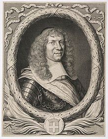
Marquis Alexandre de Prouville de Tracy
~ Wikipedia.org
His voyage into the Northwest was one of the great hardships and privations. The Indians willingly took along his French lay companions, but him they disliked. Although M. Tracy, the governor of Quebec, had made Father Allouez his ambassador to the Upper Algonquins, thus to facilitate his reception in their country, nevertheless they opposed him accompanying them, and threatened to abandon him on some desolate island. No doubt the medicine-men were the principal instigators of this opposition. He was usually obliged to paddle like the rest, often till late in the night, and that frequently without anything to eat all day.
“On a certain morning,” he says, “a deer was found, dead since four or five days. It was a lucky acquisition for poor famished beings. I was offered some, and although the bad smell hindered some from eating it, hunger made me take my share. But I had in consequence an offensive odor in my mouth until the next day. In addition to all these miseries we met with, at the rapids I used to carry packs as large as possible for my strength; but I often succumbed, and this gave our Indians occasion to laugh at me. They used to make fun of me, saying a child ought to be called to carry me and my baggage.”
August 24, they arrived at Lake Huron, where they made a short stay; then coasting along the shores of that lake, they arrived at Sault Ste. Marie towards the beginning of September. September 2, they entered Lake Superior, which the Father named Lake Tracy in acknowledgement of the obligations which the people of those upper countries owed to the governor. Speaking of his voyage on Lake Superior, Father Allouez remarks:
“Having entered Lake Tracy, we were engaged the whole month of September in coasting along the south shore. I had the consolation of saying holy mass, as I now found myself alone with our Frenchmen, which I had not been able to do since my departure from Three Rivers. * * * We afterwards passed the bay, called by the aged, venerable Father Ménard, Sait Theresa [Keweenaw] Bay.”
Speaking of his arrival at Chequamegon Bay, he says:
“After having traveled a hundred and eighty leagues on the south shore of Lake Tracy, during which our Saviour often deigned to try our patience by storms, hunger, daily and nightly fatigues, we finally, on the first day of October, 1665, arrived at Chagaouamigong, for which place we had sighed so long. It is a beautiful bay, at the head of which is situated the large village of the Indians, who there cultivate fields of Indian corn and do not lead a nomadic life. There are at this place men bearing arms, who number about eight hundred; but these are gathered together from seven different tribes, and live in peacable community. This great number of people induced us to prefer this place to all others for our ordinary abode, in order to attend more conveniently to the instruction of these heathens, to put up a chapel there and commence the functions of Christianity.”
Further on, speaking of the site of his mission and its chapel, he remarks:
“The section of the lake shore, where we have settled down, is between two large villages, and is, as it were, the center of all the tribes of these countries, because the fishing here is very good, which is the principal source of support of these people.”
To locate still more precisely the exact site of his chapel, he remarks, speaking of the three Ottawa clans (Outaouacs, Kiskakoumacs, and Outaoua-Sinagonc):
“I join these tribes [that is, speaks of them as one tribe] because they had one and the same language, which is the Algonquin, and compose one of the same village, which is opposite that of the Tionnontatcheronons [Hurons of the Petun tribe] between which villages we reside.”
But where was that Ottawa village? A casual remark of Allouez, when speaking of the copper mines of Lake Superior, will help us locate it.
“It is true,” says he, “on the mainland, at the place where the Outaouacs raise Indian corn, about half a league from the edge of the water, the women have sometimes found pieces of copper scattered here and there, weighing ten, twenty or thirty pounds. It is when digging into the sand to conceal their corn that they make these discoveries.”
Detail of Fish Creek from Township 47 North Range 5 West.
~ Wisconsin Public Land Survey Records
Allouez evidently means Fish Creek. About a mile or so from the shore of the bay, going up this creek, can be seen traces of an ancient clearing on the left-hand side, where Metabikitigweiag Creeek empties into Fish Creek, about half-way between Ashland and Ashland Junction. The writer examined the locality about ten years ago. This then is the place where the Ottawas raised Indian corn and had their village. In Charlevoix’s History of New France, the same place is marked as the site of an ancient large village. The Ottawa village on Fish Creek appears to have been the larger of the two at the head of Chequamegon Bay, and it was there Allouez resided for a time, until he was obliged to return to his ordinary dwelling place, “three-fourths of a league distant.” This shows that the ordinary abode of Father Allouez and Marquette, the site of their chapel, was somewhere near Whittlesey’s Creek or Shore’s Landing. The Huron village was most probably along the western shore of the bay, between Shore’s Landing and Washburn.
Detail of Ashland next to an ancient large village (unmarked) in Township 47 North Range 4 West.
~ Wisconsin Public Land Survey Records
Father Allouez did not confine his apostolic labors to the two large village at the head of the bay. He traveled all over the neighborhood, visiting the various shore hamlets, and he also spent a month at the western extremity of Lake Superior – probably at Fond du Lac – where he met with some Chippewas and Sioux. In 1667 he crossed the lake, most probably from Sand Island, in a frail birch canoe, and visited some Nipissirinien Christians at Lake Nepigon (Allimibigong). The same year he went to Quebec with an Indian flotilla, and arrived there on the 3d of August, 1667. After only two days’ rest he returned with the same flotilla to his far distant mission on Chequamegon Bay, taking along Father Louis Nicholas. Allouez contained his missionary labors here until 1669, when he left to found St. Francis Xavier mission at the head of Green Bay. His successor at Chequamegon Bay was Father James Marquette, discoverer and explorer of the Mississippi. Marquette arrived here September 13, 1669, and labored until the spring of 1671, when he was obliged to leave on account of the war which had broken out the year before, between the Algonquin Indians at Chequamegon Bay and their western neighbors, the Sioux.
1 – See ante, p. 419 for map of the bay. – ED.
2 – In writing Indian names, I follow Baraga’s system of orthography, giving the French quality to both consonants and vowels.
3 – Minn. Hist. Colls., v. – ED.
4 – See ante, p. 399, note. – ED.
5 – See Carr’s interesting and exhaustive article, “The Food of Certain American Indians,” in Amer. Antiq. Proc., x., pp. 155 et seq. – ED.
6 – Minn. Hist. Colls., v. – ED.
7 – In Charlevoix’s Nouvelle France. – ED.
8 – See Radisson’s Journal, in Wis. Hist. Colls., xi. Radisson and Groseilliers reached Chequamegon Bay late in the autumn of 1661. – ED.
9 – Ibid., p. 73: “I went to the wood some 3 or 4 miles. I find a small brooke, where I walked by ye sid awhile, wch brought me into meddowes. There was a poole, where weare a good store of bustards.” – ED.
10 – Ex-Lieut. Gov. Sam. S. Fifield, of Ashland, writes me as follows:
“After re-reading Radisson’s voyage to Bay Chewamegon, I am satisfied that it would by his description be impossible to locate the exact spot of his camp. The stream in which he found the “pools,” and where he shot fowl, is no doubt Fish Creek, emptying into the bay at its western extremity. Radisson’s fort must have been near the head of the bay, on the west shore, probably at or near Boyd’s Creek, as there is an outcropping of rock in that vicinity, and the banks are somewhat higher than at the head of the bay, where the bottom lands are low and swampy, forming excellent “duck ground” even to this day. Fish Creek has three outlets into the bay, – one on the east shore or near the east side, one central, and one near the western shore; for full two miles up the stream, it is a vast swamp, through which the stream flows in deep, sluggish lagoons. Here, in the early days of American settlement, large brook trout were plenty; and even in my day many fine specimens have been taken from these “pools.” Originally, there was along these bottoms a heavy elm forest, mixed with cedar and black ash, but it has now mostly disappeared. An old “second growth,” along the east side, near Prentice Park, was evidently once the site of an Indian settlement, probably of the 18th century.
“I am of the opinion that the location of Allouez’s mission was at the mouth of Vanderventer’s Creek, on the west shore of the bay, near the present village of Washburn. It was undoubtedly once the site of a large Indian village, as was the western part of the present city of Ashland. When I came to this locality, nearly a quarter of a century ago, “second growth” spots could be seen in several places, where it was evident that the Indians had once had clearings for their homes. The march of civilization has obliterated these landmarks of the fur-trading days, when the old French voyageurs made the forest-clad shores of our beautiful bay echo with their boat songs, and when resting from their labors sparked the dusky maidens in their wigwams.”
Rev. E. P. Wheeler, of Ashland, a native of Madelaine Island, and an authority on the region, writes me:
“I think Radisson’s fort was at the mouth of Boyd’s Creek, – at least that place seems for the present to fulfill the conditions of his account. it is about three or four miles from here to Fish Creek valley, which leads, when followed down stream, to marshes ‘meadows, and a pool.’ No other stream seems to have the combination as described. Boyd’s Creek is about four miles from the route he probably took, which would be by way of the plateau back from the first level, near the lake. Radisson evidently followed Fish Creek down towards the lake, before reaching the marshes. This condition is met by the formation of the creek, as it is some distance from the plateau through which Fish Creek flows to its marshy expanse. Only one thing makes me hesitate about coming to a final decision, – that is, the question of the age of the lowlands and formations around Whittlesey Creek. I am going to go over the ground with an expert geologist, and will report later. Thus far, there seems to be no reason to doubt that Fish Creek is the one upon which Radisson hunted.” – ED.
11 – Minn. Hist. Colls., v., pp. 121, 122, gives the date as 1652. – ED.
Among The Otchipwees: III
July 20, 2016
By Amorin Mello
… continued from Among The Otchipwees: II

Magazine of Western History Illustrated
No. 4 February 1885
as republished in
Magazine of Western History: Volume I, pages 335-342.
AMONG THE OTCHIPWEES.
III.
The Northern tribes have nothing deserving the name of historical records. Their hieroglyphics or pictorial writings on trees, bark, rocks and sheltered banks of clay relate to personal or transient events. Such representations by symbols are very numerous but do not attain to a system.
Their history prior to their contact with the white man has been transmitted verbally from generation to generation with more accuracy than a civilized people would do. Story-telling constitutes their literature. In their lodges they are anything but a silent people. When their villages are approached unawares, the noise of voices is much the same as in the camps of parties on pic-nic excursions. As a voyageur the pure blood is seldom a success, and one of the objections to him is a disposition to set around the camp-fire and relate his tales of war or of the hunt, late into the night. This he does with great spirit, “suiting the action to the word” with a varied intonation and with excellent powers of description. Such tales have come down orally from old to young many generations, but are more mystical than historical. The faculty is cultivated in the wigwam during long winter nights, where the same story is repeated by the patriarchs to impress it on the memory of the coming generation. With the wild man memory is sharp, and therefore tradition has in some cases a semblance to history. In substance, however, their stories lack dates, the subjects are frivolous or merely romantic, and the narrator is generally given to embellishment. He sees spirits everywhere, the reality of which is accepted by the child, who listens with wonder to a well-told tale, in which he not only believes, but is preparing to be a professional story-teller himself.
Indian picture-writings and inscriptions, in their hieroglyphics, are seen everywhere on trees, rocks and pieces of bark, blankets and flat pieces of wood. Above Odanah, on Bad River, is a vertical bank of clay, shielded from storms by a dense group of evergreens. On this smooth surface are the records of many generations, over and across each other, regardless of the rights of previous parties. Like most of their writings, they relate to trifling events of the present, such as the route which is being traveled; the game killed; or the results of a fight. To each message the totem or dodem of the writer is attached, by which he is at once recognized. But there are records of some consequence, though not strictly historical.

Charles Whittlesey also reproduced Okandikan’s autobiography in Western Reserve Historical Society Tract 41.
Before a young man can be considered a warrior, he must undergo an ordeal of exposure and starvation. He retires to a mountain, a swamp, or a rock, and there remains day and night without food, fire or blankets, as long as his constitution is able to endure the exposure. Three or four days is not unusual, but a strong Indian, destined to be a great warrior, should fast at least a week. One of the figures on this clay bank is a tree with nine branches and a hand pointing upward. This represents the vision of an Indian known to one of my voyagers, which he saw during his seclusion. He had fasted nine days, which naturally gave him an insight of the future, and constituted his motto, or chart of life. In tract No. 41 (1877), of the Western Reserve Historical Society, I have represented some of the effigies in this group; and also the personal history of Kundickan, a Chippewa, whom I saw in 1845, at Ontonagon. This record was made by himself with a knife, on a flat piece of wood, and is in the form of an autobiography. In hundreds of places in the United States such inscriptions are seen, of the meaning of which very little is known. Schoolcraft reproduced several of them from widely separated localities, such as the Dighton Boulder, Rhode Island; a rock on Kelley’s Island, Lake Erie, and from pieces of birch bark, conveying messages or memoranda to aid an orator in his speeches.
~ New Sources of Indian History, 1850-1891: The Ghost Dance and the Prairie Sioux, A Miscellany by Stanley Vestal, 2015, page 269.
The “Indian rock” in the Susquehanna River, near Columbia, Pennsylvania; the God Rock, on the Allegheny, near Brady’s Bend; inscriptions on the Ohio River Rocks, near Wellsville, Ohio, and near the mouth of the Guyandotte, have a common style, but the particular characters are not the same. Three miles west of Barnsville, in Belmont County, Ohio, is a remarkable group of sculptured figures, principally of human feet of various dimensions and uncouth proportions. Sitting Bull gave a history of his exploits on sheets of paper, which he explained to Dr. Kimball, a surgeon in the army, published in fascimile in Harper’s Weekly, July 1876. Such hieroglyphics have been found on rocky faces in Arizona, and on boulders in Georgia.

Pointe De Froid is the northwestern extremity of La Pointe on Madeline Island. Map detail from 1852 PLSS survey.
~ Report of a geological survey of Wisconsin, Iowa, and Minnesota: and incidentally of a portion of Nebraska Territory, by David Dale Owen, 1852, page 420.
~ Geology of Wisconsin: Paleontology by R. P. Whitfield, 1880, page 58.
While pandemonium was let loose at La Pointe towards the close of the payment we made a bivouac on the beach, between the dock and the mission house. The voyageurs were all at the great finale which constitutes the paradise of a Chippewa. One of my local assistants was playing the part of a detective on the watch for whisky dealers. We had seen one of them on the head waters of Brunscilus River, who came through the woods up the Chippewa River. Beyond the village of La Pointe, on a sandy promontory called Pointe au Froid, abbreviated to Pointe au Fret or Cold Point, were about twenty-five lodges, and probably one hundred and fifty Indians excited by liquor. For this, diluted with more than half water, they paid a dollar for each pint, and the measure was none too large – neither pressed down nor running over. Their savage yells rose on the quiet moon-lit atmosphere like a thousand demons. A very little weak whisky is sufficient to work wonders in the stomach of a backwoods Indian, to whom it is a comparative stranger. About midnight the detective perceived our traveler from the Chippewa River quietly approaching the dock, to which he tied his canoe and went among the lodges. To the stern there were several kegs of fire-water attached, but weighted down below the surface of the water. It required but a few minutes to haul them in and stave the heads of all of them. Before morning there appeared to be more than a thousand savage throats giving full play to their powerful lungs. Two of them were staggering along the beach toward where I lay, with one man by my side. he said we had better be quiet, which, undoubtedly, was good advice. They were nearly naked, locked arm in arm, their long hair spread out in every direction, and as they swayed to and fro between the water line and the bushes, no imagination could paint a more complete representation of the demon. There was a yell to every step – apparently a bacchanalian song. They were within two yards before they saw us, and by one leap cleared everything, as though they were as much surprised as we were. The song, or howl, did not cease. It was kept up until they turned away from the beach into the mission road, and went on howling over the hill toward the old fort. It required three days for half-breed and full-blood alike to recover from the general debauch sufficiently to resume the oar and pack. As we were about to return to the Penoka Mountains, a Chippewa buck, with a new calico shirt and a clean blanket, wished to know if the Chemokoman would take him to the south shore. He would work a paddle or an oar. Before reaching the head of the Chegoimegon Bay there was a storm of rain. He pulled off his shirt, folded it and sat down upon it, to keep it dry. The falling rain on his bare back he did not notice.

Portrait of Stephen Bonga
~ Wisconsin Historical Society
We had made the grand portage of nine miles from the foot of the cataract of the St. Louis, above Fond du Lac, and encamped on the river where the trail came to it below the knife portage. In the evening Stephen Bungo, a brother of Charles Bungo, the half-breed negro and Chippewa, came into our tent. He said he had a message from Naugaunup, second chief of the Fond du Lac band, whose home as at Ash-ke-bwau-ka, on the river above. His chief wished to know by what authority we came through the country without consulting him. After much diplomatic parley Stephen was given some pequashigon and went to his bivouac.

Joseph Granville Norwood
~ Wikipedia.org

Portrait of Naagaanab
~ Minnesota Historical Society
The next morning he intimated that we must call at Naugaunup’s lodge on the way up, where probably permission might be had, by paying a reasonable sum, to proceed. We found him in a neat wigwam with two wives, on a pleasant rise of the river bluff, clear of timber, where there had been a village of the same name. His countenance was a pleasant one, very closely resembling that of Governor Corwin, of Ohio, but his features were smaller and also his stature. Dr. Norwood informed him that we had orders from the Great Father to go up the St. Louis to its source, thence to the waters running the other way to the Canada line. Nothing but force would prevent us from doing this, and if he was displeased he should make a complaint to the Indian agent at La Pointe, and he would forward it to Washington. We heard no more of the invasion of his territory, and he proceeded to do what very few Chippewas will do, offered to show us valuable minerals. In the stream was a pinnacle of black sale, about sixty feet high. Naugaunup soon appeared from behind it, near the top, in a position that appeared to be inaccessible, a very picturesque object pointing triumphantly to some veins of white quartz, which are very common in metamorphic slate.
Those who have heard him, say that he was a fine orator, having influence over his band, a respectable Indian, and a good negotiator. If he imagined there was value in those seams of quartz it is quite remarkable and contrary to universal practice among Chippewas that he should show them to white men. They claim that all minerals belong to the tribe. An Indian who received a price for showing them, and did not give every one his share, would be in danger of his life. They had also a superstitious dread of some great evil if they disclosed anything of the kind. Some times they promise to do so, but when they arrive at the spot, with some verdant white man, expecting to become suddenly rich, the Great Spirit or the Bad Manitou has carried it away. I have known more than one such instance, where persons have been sustained by hopeful expectation after many days of weary travel into the depths of the forest. The editor of the Ontonagon Miner gives one of the instances in his experience:
“Many years ago when Iron River was one of the fur stations, of John Jacob Astor and the American Fur Company, the Indians were known to have silver in its native state in considerable quantities.”
Men are now living who have seen them with chunks of the size of a man’s fist, but no one ever succeeded in inducing them to tell or show where the hidden treasure lay. A mortal dread clung to them, that if they showed white men a deposit of mineral the Great Manitou would punish them with death.
Several years since a half-breed brought in very fine specimens of vein rock, carrying considerable quantities of native silver. His report was that his wife had found it on the South Range, where they were trapping. To test his story he was sent back for more. In a few days he returned bringing with him quite a chunk from which was obtained eleven and one-half ounces of native silver. He returned home, went among the Flambeaux Indians and was killed. His wife refused to listen to any proposals or temptation from friend or foe to show the location of this vein, clinging with religious tenacity to the superstitious fears of her tribe.
When the British had a fort on St. Joseph’s Island in the St. Mary’s River, in the War of 1812, an Indian brought in a rich piece of copper pyrites. The usual mode of getting on good terms with him, by means of whisky, failed to get from him the location of the mineral. Goods were offered him; first a bundle, then a pile, afterwards a canoe-load, and finally enough to load a Mackinaw boat. No promise to disclose the place, no description or hint could be extorted. It was probably a specimen from the veins on the Bruce or Wellington mining property, only about twenty miles distant on the Canadian shore.
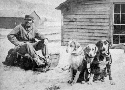
Detail of John Beargrease the Younger from stereograph “Lake Superior winter mail line” by B. F. Childs, circa 1870s-1880s.
~ Commons.Wikimedia.org
Crossing over the portage from the St. Louis River to Vermillion River, one of the voyageurs heard the report of a distant shot. They had expected to meet Bear’s Grease, with his large family, and fired a gun as a signal to them. The ashes of their fire were still warm. After much shouting and firing, it was evident that we should have no Indian society at that time. That evening, around an ample camp fire, we heard the history of the old patriarch. His former wives had borne him twenty-four children; more boys than girls. Our half-breed guide had often been importuned to take one of the girls. The old father recommended her as a good worker, and if she did not work he must whip her. Even a moderate beating always brought her to a sense of her duties. All he expected was a blanket and a gun as an offset. He would give a great feast on the occasion of the nuptials. Over the summit to Vermillion, through Vermillion Lake, passing down the outlet among many cataracts to the Crane Lake portage, there were encamped a few families, most of them too drunk to stand alone. There were two traders, from the Canada side, with plenty of rum. We wanted a guide through the intricacies of Rainy Lake. A very good-looking savage presented himself with a very unsteady gait, his countenance expressing the maudlin good nature of Tam O’Shanter as he mounted Meg. Withal, he appeared to be honest. “Yes, I know that way, but, you see, I’m drunk; can’t you wait till to-morrow.” A young squaw who apparently had not imbibed fire-water, had succeeded in acquiring a pewter ring. Her dress was a blanket of rabbit skins, made of strips woven like a rag carpet. It was bound around her waist with a girdle of deer’s hide, answering the purpose of stroud and blanket. No city belle could exhibit a ring of diamonds more conspicuously and with more self-satisfaction than this young squaw did her ring of pewter.
As we were all silently sitting in the canoes, dripping with rain, a sudden halloo announced the approach of living men. It was no other than Wau-nun-nee, the chief of the Grand Fourche bands, who was hunting for ducks among the rice. More delicious morsels never gladdened the palate than these plump, fat, rice-fed ducks. Old Wau-nun-nee is a gentleman among Indian chiefs. His band had never consented to sell their land, and consequently had no annuities. He even refused to receive a present from the Government as one of the head men of the tribe, preferring to remain wholly independent. We soon came to his village on Ash-ab-ash-kaw Lake. No band of Indians in our travels appeared as comfortable or behaved as well as this. Their country is well supplied with rice and tolerably good hunting ground. The American fur dealers (I mean the licensed ones) do not sell liquor to the Indians, and use their influence to aid Government in keeping it from them. Wau-nun-nee’s baliwick was seldom disturbed by drunken brawls. His Indians had more pleasant countenances than any we had seen, with less of the wild and haggard look than the annuity Indians. It was seldom they left their grounds, for they seldom suffered from hunger. They were comfortably clothed, made no importunities for kokoosh or pequashigon, and in gratifying their savage curiosity about our equipments they were respectful and pleasant. In his lodge the chief had teacups and saucers, with tea and sugar for his white guests, which he pressed us to enjoy. But we had no time for ceremonials, and had tea and sugar of our own. Our men recognized numerous acquaintances among the women, and as we encamped near a second village at Round Lake they came to make a draft on our provision chest. We here laid in a supply of wild rice in exchange for flour. Among this band we saw bows and arrows used to kill game. They have so little trade with the whites, and are so remote from the depots of Indian goods, that powder and lead are scarce, and guns also. For ducks and geese the bow and arrow is about as effectual as powder and shot. In truth, the community of which Wau-nun-nee was the patriarch came nearer to the pictures of Indians which poets are fond of drawing than any we saw. The squaws were more neatly clad, and their hair more often combed and braided and tied with a piece of ribbon or red flannel, with which their pappooses delighted to sport. There were among them fewer of those distinguished smoke-dried, sore-eyed creatures who present themselves at other villages.
By my estimate the channel, as we followed it to the head of the Round Lake branch, is two hundred and two mile in length, and the rise of the stream one hundred and eight feet. The portage to a stream leading into the Mississippi is one mile.
At Round Lake we engaged two young Indians to help over the portage in Jack’s place. Both of them were decided dandies, and one, who did not overtake us till late the next morning, gave an excuse that he had spent the night in courting an Indian damsel. This business is managed with them a little differently than with us. They deal largely in charms, which the medicine men furnish. This fellow had some pieces of mica, which he pulverized, and was managing to cause his inamorata to swallow. If this was effected his cause was sure to succeed. He had also some ochery, iron ore and an herb to mix with the mica. Another charm, and one very effectual, is composed of a hair from the damsel’s head placed between two wooden images. Our Lothario had prepared himself externally so as to produce a most killing effect. His hair was adorned with broad yellow ribbons, and also soaked in grease. On his cheeks were some broad jet black stripes that pointed, on both sides, toward his mouth; in his ears and nose, some beads four inches long. For a pouch and medicine bag he had the skin of a swan suspended from his girdle by the neck. His blanket was clean, and his leggings wrought with great care, so that he exhibited a most striking collection of colors.
At Round Lake we overtook the Cass Lake band on their return from the rice lakes. This meeting produced a great clatter of tongues between our men and the squaws, who came waddling down a slippery bank where they were encamped. There was a marked difference between these people and those at Ash-ab-ash-kaw. They were more ragged, more greasy, and more intrusive.
