Perrault, Curot, Nelson, and Malhoit
March 8, 2014

Click to enlarge (it can only be read when the image is full size).
I’ve been getting lazy, lately, writing all my posts about the 1850s and later. It’s easy to find sources about that because they are everywhere, and many are being digitized in an archival format. It takes more work to write a relevant post about the earlier eras of Chequamegon History. The sources are sparse, scattered, and the ones that are digitized or published have largely been picked over and examined by other researchers. However, that’s no excuse. Those earlier periods are certainly as interesting as the mid-19th Century. I needed to just jump in and do a project of some sort.
I’m someone who needs to know the names and personalities involved to truly wrap my head around a history. I’ve never been comfortable making inferences and generalizations unless I have a good grasp of the specific. This doesn’t become easy in the Lake Superior country until after the Cass Expedition in 1820.
But what about a generation earlier?
The dawn of the 19th-century was a dynamic time for our region. The fur trade was booming under the British North West Company. The Ojibwe were expanding in all directions, especially to west, and many of familiar French surnames that are so common in the area arrived with Canadian and Ojibwe mix-blooded voyageurs. Admittedly, the pages of the written record around 1800 are filled with violence and alcohol, but that shouldn’t make one lose track of the big picture. Right or wrong, sustainable or not, this was a time of prosperity for many. I say this from having read numerous later nostalgic accounts from old chiefs and voyageurs about this golden age.
We can meet some of the bigger characters of this era in the pages of William W. Warren and Henry Schoolcraft. In them, men like Mamaangazide (Mamongazida “Big Feet”) and Michel Cadotte of La Pointe, Beyazhig (Pay-a-jick “Lone Man) of St. Croix, and Giishkiman (Keeshkemun “Sharpened Stone”) of Lac du Flambeau become titans, covered with glory in trade, war, and influence. However, there are issues with these accounts. These two authors, and their informants, are prone toward glorifying their own family members. Considering that Schoolcraft’s (his mother-in law, Ozhaawashkodewike) and Warren’s (Flat Mouth, Buffalo, Madeline and Michel Cadotte Jr., Jean Baptiste Corbin, etc.) informants were alive and well into adulthood by 1800, we need to keep things in perspective.
The nature of Ojibwe leadership wasn’t different enough in that earlier era to allow for a leader with any more coercive power than that of the chiefs in 1850s. Mamaangazide and his son Waabojiig may have racked up great stories and prestige in hunting and war, but their stature didn’t get them rich, didn’t get them out of performing the same seasonal labors as the other men in the band, and didn’t guarantee any sort of power for their descendants. In the pages of contemporary sources, the titans of Warren and Schoolcraft are men.
Finally, it should be stated that 1800 is comparatively recent. Reading the journals and narratives of the Old North West Company can make one feel completely separate from the American colonization of the Chequamegon Region in the 1840s and ’50s. However, they were written at a time when the Americans had already claimed this area for over a decade. In fact, the long knife Zebulon Pike reached Leech Lake only a year after Francois Malhoit traded at Lac du Flambeau.
The Project
I decided that if I wanted to get serious about learning about this era, I had to know who the individuals were. The most accessible place to start would be four published fur-trade journals and narratives: those of Jean Baptiste Perrault (1790s), George Nelson (1802-1804), Michel Curot (1803-1804), and Francois Malhoit (1804-1805).
The reason these journals overlap in time is that these years were the fiercest for competition between the North West Company and the upstart XY Company of Sir Alexander MacKenzie. Both the NWC traders (such as Perrault and Malhoit) and the XY traders (Nelson and Curot) were expected to keep meticulous records during these years.
I’d looked at some of these journals before and found them to be fairly dry and lacking in big-picture narrative history. They mostly just chronicle the daily transactions of the fur posts. However, they do frequently mention individual Ojibwe people by name, something that can be lacking in other primary records. My hope was that these names could be connected to bands and villages and then be cross-referenced with Warren and Schoolcraft to fill in some of the bigger story. As the project took shape, it took the form of a map with lots of names on it. I recorded every Ojibwe person by name and located them in the locations where they met the traders, unless they are mentioned specifically as being from a particular village other than where they were trading.
I started with Perrault’s Narrative and tried to record all the names the traders and voyageurs mentioned as well. As they were mobile and much less identified with particular villages, I decided this wasn’t worth it. However, because this is Chequamegon History, I thought I should at least record those “Frenchmen” (in quotes because they were British subjects, some were English speakers, and some were mix-bloods who spoke Ojibwe as a first language) who left their names in our part of the world. So, you’ll see Cadotte, Charette, Corbin, Roy, Dufault (DeFoe), Gauthier (Gokee), Belanger, Godin (Gordon), Connor, Bazinet (Basina), Soulierre, and other familiar names where they were encountered in the journals. I haven’t tried to establish a complete genealogy for either, but I believe Perrault (Pero) and Malhoit (Mayotte) also have names that are still with us.
For each of the names on the map, I recorded the narrative or journal they appeared in:
JBP= Jean Baptiste Perrault
GN= George Nelson
MC= Michel Curot
FM= Francois Malhoit

Red Lake-Pembina area: By this time, the Ojibwe had started to spread far beyond the Lake Superior forests and into the western prairies. Perrault speaks of the Pillagers (Leech Lake Band) being absent from their villages because they had gone to hunt buffalo in the west. Vincent Roy Sr. and his sons later settled at La Pointe, but their family maintained connections in the Canadian borderlands. Jean Baptiste Cadotte Jr. was the brother of Michel Cadotte (Gichi-Mishen), the famous La Pointe trader.

Leech Lake and Sandy Lake area: The names that jump out at me here are La Brechet or Gaa-dawaabide (Broken Tooth), the great Loon-clan chief from Sandy Lake (son of Bayaaswaa mentioned in this post) and Loon’s Foot (Maangozid). The Maangozid we know as the old speaker and medicine man from Fond du Lac (read this post) was the son of Gaa-dawaabide. He would have been a teenager or young man at the time Perrault passed through Sandy Lake.

Fond du Lac and St. Croix: Augustin Belanger and Francois Godin had descendants that settled at La Pointe and Red Cliff. Jean Baptiste Roy was the father of Vincent Roy Sr. I don’t know anything about Big Marten and Little Marten of Fond du Lac or Little Wolf of the St. Croix portage, but William Warren writes extensively about the importance of the Marten Clan and Wolf Clan in those respective bands. Bayezhig (Pay-a-jick) is a celebrated warrior in Warren and Giishkiman (Kishkemun) is credited by Warren with founding the Lac du Flambeau village. Buffalo of the St. Croix lived into the 1840s. I wrote about his trip to Washington in this post.
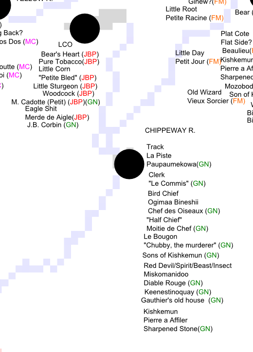
Lac Courte Oreilles and Chippewa River: Many of the men mentioned at LCO by Perrault are found in Warren. Little (Petit) Michel Cadotte was a cousin of the La Pointe trader, Big (Gichi/La Grande) Michel Cadotte. The “Red Devil” appears in Schoolcraft’s account of 1831. The old, respected Lac du Flambeau chief Giishkiman appears in several villages in these journals. As the father of Keenestinoquay and father-in-law of Simon Charette, a fur-trade power couple, he traded with Curot and Nelson who worked with Charette in the XY Company.

La Pointe: Unfortunately, none of the traders spent much time at La Pointe, but they all mention Michel Cadotte as being there. The family of Gros Pied (Mamaangizide, “Big Feet”) the father of Waabojiig, opened up his lodge to Perrault when the trader was waylaid by weather. According to Schoolcraft and Warren, the old war chief had fought for the French on the Plains of Abraham in 1759.

Lac du Flambeau: Malhoit records many of the same names in Lac du Flambeau that Nelson met on the Chippewa River. Simon Charette claimed much of the trade in this area. Mozobodo and “Magpie” (White Crow), were his brothers-in-law. Since I’ve written so much about chiefs named Buffalo, I should point out that there’s an outside chance Le Taureau (presumably another Bizhiki) could be the famous Chief Buffalo of La Pointe.

L’Anse, Ontonagon, and Lac Vieux Desert: More Cadottes and Roys, but otherwise I don’t know much about these men.

At Mackinac and the Soo, Perrault encountered a number of names that either came from “The West,” or would find their way there in later years. “Cadotte” is probably Jean Baptiste Sr., the father of “Great” Michel Cadotte of La Pointe.

Malhoit meets Jean Baptiste Corbin at Kaministiquia. Corbin worked for Michel Cadotte and traded at Lac Courte Oreilles for decades. He was likely picking up supplies for a return to Wisconsin. Kaministiquia was the new headquarters of the North West Company which could no longer base itself south of the American line at Grand Portage.
Initial Conclusions
There are many stories that can be told from the people listed in these maps. They will have to wait for future posts, because this one only has space to introduce the project. However, there are two important concepts that need to be mentioned. Neither are new, but both are critical to understanding these maps:
1) There is a great potential for misidentifying people.
Any reading of the fur-trade accounts and attempts to connect names across sources needs to consider the following:
- English names are coming to us from Ojibwe through French. Names are mistranslated or shortened.
- Ojibwe names are rendered in French orthography, and are not always transliterated correctly.
- Many Ojibwe people had more than one name, had nicknames, or were referenced by their father’s names or clan names rather than their individual names.
- Traders often nicknamed Ojibwe people with French phrases that did not relate to their Ojibwe names.
- Both Ojibwe and French names were repeated through the generations. One should not assume a name is always unique to a particular individual.
So, if you see a name you recognize, be careful to verify it’s reall the person you’re thinking of. Likewise, if you don’t see a name you’d expect to, don’t assume it isn’t there.
2) When talking about Ojibwe bands, kinship is more important than physical location.
In the later 1800s, we are used to talking about distinct entities called the “St. Croix Band” or “Lac du Flambeau Band.” This is a function of the treaties and reservations. In 1800, those categories are largely meaningless. A band is group made up of a few interconnected families identified in the sources by the names of their chiefs: La Grand Razeur’s village, Kishkimun’s Band, etc. People and bands move across large areas and have kinship ties that may bind them more closely to a band hundreds of miles away than to the one in the next lake over.
I mapped here by physical geography related to trading posts, so the names tend to group up. However, don’t assume two people are necessarily connected because they’re in the same spot on the map.
On a related note, proximity between villages should always be measured in river miles rather than actual miles.
Going Forward
I have some projects that could spin out of these maps, but for now, I’m going to set them aside. Please let me know if you see anything here that you think is worth further investigation.
Sources:
Curot, Michel. A Wisconsin Fur Trader’s Journal, 1803-1804. Edited by Reuben Gold Thwaites. Wisconsin Historical Collections, vol. XX: 396-472, 1911.
Malhoit, Francois V. “A Wisconsin Fur Trader’s Journal, 1804-05.” Collections of the State Historical Society of Wisconsin. Ed. Reuben Gold Thwaites. Vol. 19. Madison: State Historical Society of Wisconsin, 1910. 163-225. Print.
Nelson, George, Laura L. Peers, and Theresa M. Schenck. My First Years in the Fur Trade: The Journals of 1802-1804. St. Paul, MN: Minnesota Historical Society, 2002. Print.
Perrault, Jean Baptiste. Narrative of The Travels And Adventures Of A Merchant Voyager In The Savage Territories Of Northern America Leaving Montreal The 28th of May 1783 (to 1820) ed. and Introduction by, John Sharpless Fox. Michigan Pioneer and Historical Collections. vol. 37. Lansing: Wynkoop, Hallenbeck, Crawford Co., 1900.
Schoolcraft, Henry Rowe. Information Respecting The History,Condition And Prospects OF The Indian Tribes Of The United States. Illustrated by Capt. S. Eastman. Published by the Authority of Congress. Part III. Philadelphia: Lippincott, Grambo & Company, 1953.
Schoolcraft, Henry Rowe, and Philip P. Mason. Expedition to Lake Itasca; the Discovery of the Source of the Mississippi. East Lansing: Michigan State UP, 1958. Print.
Warren, William W., and Theresa M. Schenck. History of the Ojibway People. St. Paul: Minnesota Historical Society, 2009. Print.
Fun With Maps
June 28, 2013
I’m someone who loves a good historical map, so one of my favorite websites is memory.loc.gov, the digital collections of the Library of Congress. You can spend hours zooming in on neat vintage maps. This post has snippets from eleven of them, stretching from 1674 to 1843. They are full of cool old inaccuracies, but they also highlight important historical trends and eras in our history. This should not be considered an exhaustive survey of the best maps out there, nor is it representative of all the LOC maps. Really, it’s just 11 semi-random maps with my observations on what I found interesting. Click on any map to go to the Library of Congress site where you can browse more of it. Enjoy:
French 1674
Nouvelle decouverte de plusieurs nations dans la Nouvelle France en l’année 1673 et 1674 by Louis Joliet. Joliet famously traveled from the Great Lakes down the Mississippi with the Jesuit Jacques Marquette in 1673.
- Cool trees.
- Baye des Puans: The French called the Ho-Chunk Puans, “Stinky People.” That was a translation of the Ojibwe word Wiinibiigoo (Winnebago), which means “stinky water people.” Green Bay is “green” in summer because of the stinky green algae that covers it. It’s not surprising that the Ho-Chunk no longer wish to be called the Winnebago or Puans.
- 8tagami: The French used 8 in Indian words for the English sound “W.” 8tagami (Odagami) is the Ojibwe/Odawa/Potawatomi word for the Meskwaki (Fox) People.
- Nations du Nord: To the French, the country between Lake Superior and Hudson Bay was the home of “an infinity of nations,” (check out this book by that title) small bands speaking dialects of Ojibwe, Cree, and Assiniboine Sioux.
- The Keweenaw is pretty small, but Lake Superior has generally the right shape.
French 1688
Carte de l’Amerique Septentrionnale by Jean Baptiste Louis Franquelin: Franquelin created dozens of maps as the royal cartographer and hydrographer of New France.
- Lake Superior is remarkably accurate for this time period.
- Nations sous le nom d’Outouacs: “Nations under the name of Ottawas”–the French had a tendency to lump all Anishinaabe peoples in the west (Ojibwe, Ottawa, Potawatomi, etc.) under the name Outouais or Outouacs.
- River names, some are the same and some have changed. Bois Brule (Brule River) in French is “burnt wood” a translation of the Ojibwe wiisakode. I see ouatsicoto inside the name of the Brule on this map (Neouatsicoton), but I’m not 100% sure that’s wiisakode. Piouabic (biwaabik is Ojibwe word for Iron) for the Iron River is still around. Mosquesisipi (Mashkiziibi) or Swampy River is the Ojibwe for the Bad River.
- Madeline Island is Ile. St. Michel, showing that it was known at “Michael’s Island” a century before Michel Cadotte established his fur post.
- Ance Chagoüamigon: Point Chequamegon
French 1703
Carte de la riviere Longue : et de quelques autres, qui se dechargent dans le grand fleuve de Missisipi [sic] … by Louis Armand the Baron de Lahontan. Baron Lahontan was a military officer of New France who explored the Mississippi and Missouri River valleys.
- Lake Superior looks quite strange.
- “Sauteurs” and Jesuits at Sault Ste. Marie: the French called the Anishinaabe people at Sault Ste. Marie (mostly Crane Clan) the Sauteurs or Saulteaux, meaning “people of the falls.” This term came to encompass most of the people who would now be called Ojibwe.
- Fort Dulhut: This is not Duluth, Minnesota, but rather Kaministiquia (modern-day Thunder Bay). It is named for the same person–Daniel Greysolon, the Sieur du Lhut (Duluth).
- Riviere Du Tombeau: “The River of Tombs” at the west end of the Lake is the St. Croix River, which does not actually flow into Lake Superior but connects it to the Mississippi over a short portage from the Brule River.
- Chagouamigon (Chequamegon) is placed much too far to the east.
- The Fox River is gigantic flowing due east rather than north into Green Bay. We see the “Savage friends of the French:” Outagamis (Meskwaki/Fox), Malumins (Menominee), and Kikapous (Kickapoo).
French 1742
Carte des lacs du Canada by Jacques N. Bellin 1742. Bellin was a famous European mapmaker who compiled various maps together. The top map is a detail from the Carte de Lacs. The bottom one is from a slightly later map.
- Of the maps shown so far, this has the best depiction of Chequamegon, but Lake Superior as a whole is much less accurate than on Franquelin’s map from fifty years earlier.
- The mysterious “Isle Phillipeaux,” a second large island southeast of Isle Royale shows prominently on this map. Isle Phillipeaux is one of those cartographic oddities that pops up on maps for decades after it first appears even though it doesn’t exist.
- Cool river names not shown on Franquelin’s map: Atokas (Cranberry River) and Fond Plat “Flat-bottom” (Sand River)
- The region west of today’s Herbster, Wisconsin is lablled “Papoishika.” I did an extensive post about an area called Ka-puk-wi-e-kah in that same location.
- Ici etoit une Bourgade Considerable: “Here there was a large village.” This in reference to when Chequamegon was a center for the Huron, Ottawa (Odawa) and other refugee nations of the Iroquois Wars in the mid-1600s.
- “La Petite Fille”: Little Girl’s Point.
- Chequamegon Bay is Baye St. Charles
- Catagane: Kakagon, Maxisipi: Mashkizibi
- The islands are “The 12 Apostles.”
British 1778
A new map of North America, from the latest discoveries 1778. Engrav’d for Carver’s Travels. In 1766 Jonathan Carver became one of the first Englishmen to pass through this region. His narrative is a key source for the time period directly following the conquest of New France, when the British claimed dominion over the Great Lakes.
- Lake Superior still has two giant islands in the middle of it.
- The Chipeway (Ojibwe), Ottaway (Odawa), and Ottagamie (Meskwaki/Fox) seem to have neatly delineated nations. The reality was much more complex. By 1778, the Ojibwe had moved inland from Lake Superior and were firmly in control of areas like Lac du Flambeau and Lac Courte Oreilles, which had formerly been contested by the Meskwaki.
Dutch 1805
Charte von den Vereinigten Staaten von Nord-America nebst Louisiana by F.L. Gussefeld: Published in Europe.
- The Dutch never had a claim to this region. In fact, this is a copy of a German map. However, it was too cool-looking to pass up.
- Over 100 years after Franquelin’s fairly-accurate outline of Lake Superior, much of Europe was still looking at this junk.
- “Ober See” and Tschippeweer” are funny to me.
- Isle Phillipeau is hanging on strong into the nineteenth century.
American 1805
A map of Lewis and Clark’s track across the western portion of North America, from the Mississippi to the Pacific Ocean : by order of the executive of the United States in 1804, 5 & 6 / copied by Samuel Lewis from the original drawing of Wm. Clark. This map was compiled from the manuscript maps of Lewis and Clark.
- The Chequamegon Region supposedly became American territory with the Treaty of Paris in 1783. The reality on the ground, however, was that the Ojibwe held sovereignty over their lands. The fur companies operating in the area were British-Canadian, and they employed mostly French-Ojibwe mix-bloods in the industry.
- This is a lovely-looking map, but it shows just how little the Americans knew about this area. Ironically, British Canada is very well-detailed, as is the route of Lewis and Clark and parts of the Mississippi that had just been visited by the American, Lt. Zebulon Pike.
- “Point Cheganega” is a crude islandless depiction of what we would call Point Detour.
- The Montreal River is huge and sprawling, but the Brule, Bad, and Ontonagon Rivers do not exist.
- To this map’s credit, there is only one Isle Royale. Goodbye Isle Phillipeaux. It was fun knowing you.
- It is striking how the American’s had access to decent maps of the British-Canadian areas of Lake Superior, but not of what was supposedly their own territory.
English 1811
A new map of North America from the latest authorities By John Cary of London. This map was published just before the outbreak of war between Britain and the United States.
- These maps are starting to look modern. The rivers are getting more accurate and the shape of Lake Superior is much better–though the shoreline isn’t done very well.
- Burntwood=Brule, Donagan=Ontonagon
- The big red line across Lake Superior is the US-British border. This map shows Isle Royale in Canada. The line stops at Rainy Lake because the fate of the parts of Minnesota and North Dakota in the Hudson Bay Watershed (claimed by the Hudson Bay Company) was not yet settled.
- “About this place a settlement of the North West Company”: This is Michel Cadotte’s trading post at La Pointe on Madeline Island. Cadotte was the son of a French trader and an Anishinaabe woman, and he traded for the British North West Company.
- It is striking that a London-made map created for mass consumption would so blatantly show a British company operating on the American side of the line. This was one of the issues that sparked the War of 1812. The Indian nations of the Great Lakes weren’t party to the Treaty of Paris and certainly did not recognize American sovereignty over their lands. They maintained the right to have British traders. America didn’t see it that way.
American 1820
Map of the United States of America : with the contiguous British and Spanish possessions / compiled from the latest & best authorities by John Melish
- Lake Superior shape and shoreline are looking much better.
- Bad River is “Red River.” I’ve never seen that as an alternate name for the Bad. I’m wondering if it’s a typo from a misreading of “bad”
- Copper mines are shown on the Donagon (Ontonagon) River. Serious copper mining in that region was still over a decade away. This probably references the ancient Indian copper-mining culture of Lake Superior or the handful of exploratory attempts by the French and British.
- The Brule-St. Croix portage is marked “Carrying Place.”
- No mention of Chequamegon or any of the Apostle Islands–just Sand Point.
- Isle Phillipeaux lives! All the way into the 1820s! But, it’s starting to settle into being what it probably was all along–the end of the Keweenaw mistakenly viewed from Isle Royale as an island rather than a peninsula.
American 1839 

From the Map of Michigan and part of Wisconsin Territory, part of the American Atlas produced under the direction of U.S. Postmaster General David H. Burr.
- Three years before the Ojibwe cede the Lake Superior shoreline of Wisconsin, we see how rapidly American knowledge of this area is growing in the 1830s.
- The shoreline is looking much better, but the islands are odd. Stockton (Presque Isle) and Outer Island have merged into a huge dinosaur foot while Madeline Island has lost its north end.
- Weird river names: Flagg River is Spencer’s, Siskiwit River is Heron, and Sand River is Santeaux. Fish Creek is the gigantic Talking Fish River, and “Raspberry” appears to be labeling the Sioux River rather than the farther-north Raspberry River.
- Points: Bark Point is Birch Bark, Detour is Detour, and Houghton is Cold Point. Chequamegon Point is Chegoimegon Point, but the bay is just “The Bay.”
- The “Factory” at Madeline Island and the other on Long Island refers to a fur post. This usage is common in Canada: Moose Factory, York Factory, etc. At this time period, the only Factory would have been on Madeline.
- The Indian Village is shown at Odanah six years before Protestant missionaries supposedly founded Odanah. A commonly-heard misconception is that the La Pointe Band split into Island and Bad River factions in the 1840s. In reality, the Ojibwe didn’t have fixed villages. They moved throughout the region based on the seasonal availability of food. The traders were on the island, and it provided access to good fishing, but the gardens, wild rice, and other food sources were more abundant near the Kakagon sloughs. Yes, those Ojibwe married into the trading families clustered more often on the Island, and those who got sick of the missionaries stayed more often at Bad River (at least until the missionaries followed them there), but there was no hard and fast split of the La Pointe Band until long after Bad River and Red Cliff were established as separate reservations.
American 1843
Hydrographical basin of the upper Mississippi River from astronomical and barometrical observations, surveys, and information by Joseph Nicollet. Nicollet is considered the first to accurately map the basin of the Upper Mississippi. His Chequamegon Region is pretty good also.
- You may notice this map decorating the sides of the Chequamegon History website.
- This post mentions this map and the usage of Apakwa for the Bark River.
- As with the 1839 map, this map’s Raspberry River appears to be the Sioux rather than the Miskomin (Raspberry) River.
- Madeline Island has a little tail, but the Islands have their familiar shapes.
- Shagwamigon, another variant spelling
- Mashkeg River: in Ojibwe the Bad River is Mashkizibi (Swamp River). Mashkiig is the Ojibwe word for swamp. In the boreal forests of North America, this word had migrated into English as muskeg. It’s interesting how Nicollet labels the forks, with the White River fork being the most prominent.
That’s all for now folks. Thanks for covering 200 years of history with me through these maps. If you have any questions, or have any cool observations of your own, go ahead and post them in the comments.
Chief Buffalo, Flat Mouth, and Tecumseh
April 28, 2013
 The Shawnee Prophet, Tenskwatawa painted by Charles Bird King c.1820 (Wikimedia Commons)
In contrast with other Great Lakes nations, the Lake Superior Ojibwe are often portrayed as not having had a role in the Seven Years War, Pontiac’s War, Tecumseh’s War, or the War of 1812. The Chequamegon Ojibwe are often characterized as being uniformly friendly toward whites, peacefully transitioning from the French and British to the American era. The Ojibwe leaders Buffalo of La Pointe and Flat Mouth of Leech Lake are seen as men who led their people into negotiations rather than battle with the United States.
No one tried harder to promote the idea of Ojibwe-American friendship than William W. Warren (1825-1853), the Madeline Island-born mix-blooded historian who wrote History of the Ojibway People. Warren details Ojibwe involvement in all of these late-18th and early 20th-century imperial conflicts, but then repeatedly dismisses it as solely the work of more easterly Ojibwe bands or a few rogue warriors. The reality was much more complicated.
It is true, the Lake Superior Ojibwe never entered into these wars as a single body, but the Lake Superior Ojibwe rarely did anything as a single body. Different bands, chiefs, and families pursued different policies. What is clear from digging deeper into the sources, however, is that the anti-American resistance ideologies of men like the Tecumseh and his brother Tenskwatawa (The Prophet) had more followers around here than Warren would have you believe. The passage below, from none other than Warren himself, shows that these followers included Buffalo and Flat Mouth.
History of the Ojibway People is available free online, but I’m not going to link to it. I want you to check out or buy the second edition, edited and annotated by Theresa Schenck and published by the Minnesota Historical Society in 2009. It is not the edition I first read this story in, but this post does owe a great debt to Dr. Schenck’s footnotes. Also, if you get the book, you will find the added bonus of a second account of these same events from Julia Warren Spears, William’s sister (Appendix C). The passage that is reproduced here can be read on pages 227-231.
“… no event of any importance occured on the Chippeway and Wisconsin Rivers till the year 1808, when, under the influence of the excitement which the Shaw-nee prophet, brother of Tecumseh, succeeded in raising, even to the remotest village of the Ojibways, the men of the Lac Coutereille village, pillaged the trading house of Michel Cadotte at Lac Coutereilles, while under charge of a clerk named John Baptiste Corbin. From the lips of Mons. Corbin, who is still living at Lac Coutereille, at the advanced age of seventy-six years, and who has now been fifty-six years in the Ojibway country, I have obtained a reliable account of this transaction…”
“…In the year 1808, during the summer while John B. Corbin had charge of the Lac Coutereille post, messengers, whose faces were painted black, and whose actions appeared strange, arrived at the different principal villages of the Ojibways. In solemn councils they performed certain ceremonies, and told that the Great Spirit had at last condescended to hold communion with the red race, through the medium of a Shawano prophet, and that they had been sent to impart the glad tidings.
The Shawano sent them word that the Great Spirit was about to take pity on his red children, whom he had long forsaken for their wickedness. He bade them to return to the primitive usages and customs of their ancestors, to leave off the use of everything which the evil white race had introduced among them. Even the fire-steel must be discarded, and fire made as in ages past, by the friction of two sticks. And this fire, once lighted in their principal villages, must always be kept sacred and burning. He bade them to discard the use of fire-water—to give up lying and stealing and warring with one another. He even struck at some of the roots of the Me-da-we religion, which he asserted had become permeated with many evil medicines, and had lost almost altogether its original uses and purity. He bade the medicine men to throw away their evil and poisonous medicines, and to forget the songs and ceremonies attached thereto, and he introduced new medicines and songs in their place. He prophesied that the day was nigh, when, if the red race listened to and obeyed his words, the Great Spirit would deliver them from their dependence on the whites, and prevent their being finally down-trodden and exterminated by them. The prophet invited the Ojibways to come and meet him at Detroit, where in person, he would explain to them the revelations of the “Great Master of Life.” He even claimed the power of causing the dead to arise, and come again to life.
It is astonishing how quickly this new belief obtained possession in the minds of the Ojibways. It spread like wild-fire throughout their entire country, and even reached the remotest northern hunters who had allied themselves with the Crees and Assiniboines. The strongest possible proof which can be adduced of their entire belief, is in their obeying the mandate to throw away their medicine bags, which the Indian holds most sacred and inviolate. It is said that the shores of Sha-ga-waum-ik-ong were strewed with the remains of medicine bags, which had been committed to the deep. At this place, the Ojibways collected in great numbers. Night and day, the ceremonies of the new religion were performed, till it was at last determined to go in a body to Detroit, to visit the prophet. One hundred and fifty canoes are said to have actually started from Pt. Shag-a-waum-ik-ong for this purpose, and so strong was their belief, that a dead child was brought from Lac Coutereille to be taken to the prophet for resuscitation.
This large party arrived on their foolish journey, as far as the Pictured Rocks, on Lake Superior, when, meeting with Michel Cadotte, who had been to Sault Ste. Marie for his annual outfit of goods, his influence, together with information of the real motives of the prophet in sending for them, succeeded in turning them back.
The few Ojibways who had gone to visit the prophet from the more eastern villages of the tribe, had returned home disappointed, and brought back exaggerated accounts of the suffering through hunger, which the proselytes of the prophet who had gathered at his call, were enduring, and also giving the lie to many of the attributes which he had assumed. It is said that at Detroit he would sometimes leave the camp of the Indians, and be gone, no one knew whither, for three and four days at a time. On his return he would assert that he had been to the spirit land and communed with the master of life. It was, however, soon discovered that he only went and hid himself in a hollow oak which stood behind the hill on which the most beautiful portion of Detroit City is now built. These stories became current among the Ojibways, and each succeeding year developing more fully the fraud and warlike purpose of the Shawano, the excitement gradually died away among the Ojibways, and the medicine men and chiefs who had become such ardent believers, hung their heads in shame whenever the Shawano was mentioned.

 Two men of “strong minds and unusual intelligence,” Buffalo of La Pointe (top) and Eshkibagikoonzhe or “Flat Mouth” of Leech Lake. (Wisconsin Historical Society) (Minnesota Historical Society)
At this day it is almost impossible to procure any information on this subject from the old men who are still living, who were once believers and preached their religion, so anxious are they to conceal the fact of their once having been so egregiously duped. The venerable chiefs Buffalo, of La Pointe, and Esh-ke-bug-e-coshe, of Leech Lake, who have been men of strong minds and unusual intelligence, were not only firm believers of the prophet, but undertook to preach his doctrines.
One essential good resulted to the Ojibways through the Shawano excitement–they threw away their poisonous roots and medicines, and poisoning, which was formerly practiced by their worst class of medicine men, has since become entirely unknown.
So much has been written respecting the prophet and the new beliefs which he endeavored to inculcate amongst his red brethren, that we will no longer dwell on the merits or demerits of his pretended mission. It is now evident that he and his brother Tecumseh had in view, and worked to effect, a general alliance of the red race, against the whites, and their final extermination from the ‘Great Island which the great spirit had given as an inheritance to his red children.’”
From 1805 to 1811, the Shawnee Prophet Tenskwatawa and his brother Tecumseh spread a religious and political message from the Canadas in the north, to the Gulf of Mexico in the south, to the prairies of the west. They called for all Indians to abandon white ways, unite as one people, and create a British-protected Indian country between the Ohio and the Great Lakes. While he seldom convinced entire nations (including the Shawnee) to join him, Tecumseh gained followers from all over.
 This picture of Tecumseh in British uniform was painted decades after his death by Benson John Lossing (Wikimedia Commons)
His coalition came apart, however, at the Battle of Tippecanoe on November 7, 1811. Tecumseh was away recruiting more followers when American forces under William Henry Harrison defeated Tenskwatawa. Accounts suggest it was a closely-fought battle with the Americans suffering the most casualties. However, in the end Harrison prevailed due to his superior numbers.
With Tenskwatawa discredited, Tecumseh ended up raising a new coalition to fight alongside the British against the Americans in the War of 1812. He was killed in the Battle of the Thames, October 5, 1813, when the British forces under General Henry Procter abandoned their Indian allies on the battlefield.
After the War of 1812, British traders pulled out of their posts in American territory. However, the Ojibwe of Lake Superior continued to trade across the line in Canada. In 1822, the American agent Henry Schoolcraft’s gave his first description of Buffalo, a man he would come to know well over the next thirty-five years. He described “a chief decorated with British insignia.” Ten years later, Flat Mouth was telling Schoolcraft he had no right or ability to stop the Ojibwe from allying with the British. These chiefs were not men who were unwavering friends of the United States for their whole lives.
Buffalo and Flat Mouth lived to be very old men, and lived to see the Ojibwe cede their lands in treaties, suffer the tragic 1850-51 removal to Sandy Lake, and see the beginnings of a paternalist American regime on the newly-created reservations. Their Shawnee contemporary, Tecumseh, did not live that long.
Tecumseh’s life and death are documented in the second episode of the 2009 television miniseries American Experience: We Shall Remain. The episode, Tecumseh’s Vision, is very good throughout. The most interesting part comes at the very end when several of the expert interviewees comment on the meaning of Tecumseh’s death:
“I think Tecumseh is, in a sense, saved by his death. He’s saved for immortality through death on the battlefield.”
Stephen Warren, Augustana College
“One of the great things in icons is to bow out at the right time, and one of the things Tecumseh does is he never lets you down. He was there, articulating his position — uncompromisingly pro-Native American position. He never signs the treaties. He never reneges on those basic as principles of the sacrosanct aboriginal holding of this territory. He bows out at the peak of this great movement he is leading. He’s there, right at the end, whatever the odds are, fighting for it into the dying moments.”
John Sugden, author Tecumseh: A Life
“For some people, they may call him a troublemaker. And I think that’s because, in the end, he lost. Had he won, he’d have been, you know, a hero. But I think, to a degree, he still has to be recognized as a hero, for what he attempted to do. If he had a little more help, maybe he would have got a little farther down the line. If the British would have backed him up, like they were supposed to have, maybe the United States is only half as big as it is today.”
Sherman Tiger, Absentee Shawnee Tribe of Oklahoma
Stephen Warren and John Sugden indicate that he is a hero because of the way he died. Sherman Tiger seems to say that Tecumseh’s death, in part, is what kept him from being a hero, and that if he had more men, maybe his “vision” of a united Indian nation would have come true.
In 1811, the Ojibwe of Lake Superior and the upper Mississippi had hundreds of warriors experienced in battle with the Dakota Sioux. They were heirs to a military tradition that defeated the Iroquois and the Meskwaki (Fox). A handful of Ojibwe did fight beside Tecumseh, and according to John Baptiste Corbine through Warren, many more could have. It’s possible they could have tipped the balance and caused Tippecanoe or Thames to end differently. It is also possible that Buffalo, Flat Mouth, and other future Ojibwe leaders could have died on the battlefield.
Tecumseh died young and uncompromised. Buffalo and Flat Mouth faced many tough decisions and lived long enough to see their people lose their independence and most of their land. However, they were there to lead their people through the hard times of the removal period. Tecumseh wasn’t.
Ultimately, it’s hard to say which is more heroic? What do you think?
Sources:
Schenck, Theresa M., William W. Warren: The Life, Letters, and times of an Ojibwe Leader. Lincoln: University of Nebraska, 2007. Print.
Schoolcraft, Henry Rowe, and Philip P. Mason. Expedition to Lake Itasca; the Discovery of the Source of the Mississippi,. [East Lansing]: Michigan State UP, 1958. Print.
Schoolcraft, Henry R. Personal Memoirs of a Residence of Thirty Years with the Indian Tribes on the American Frontiers: With Brief Notices of Passing Events, Facts, and Opinions, A.D. 1812 to A.D. 1842. Philadelphia: Lippincott, Grambo and, 1851. Print.
Warren, William W., and Theresa M. Schenck. History of the Ojibway People. St. Paul: Minnesota Historical Society, 2009. Print.
White, Richard. The Middle Ground: Indians, Empires, and Republics in the Great Lakes Region, 1650-1815. Cambridge: Cambridge UP, 1991. Print.
Witgen, Michael J. An Infinity of Nations: How the Native New World Shaped Early North America. Philadelphia: University of Pennsylvania, 2012. Print.
